|
Reflections 2016
Series 14
September 19
East Coast V: Harpers Ferry Lower Town–Great Falls–DC-Water Bridges; Magpies
| | Day 7: Harpers Ferry Lower Town After a cozy evening by the fire and hearty breakfast this morning, it's time to finally take a close look at Lower Town that only a complete, self-planned walking tour can provide. But we should point out on the way that, while down on the floodplain we have the National Historic Park, in the upper town we also have the Harpers Ferry Historic District, where, in the late 19C, a number of
Victorian (Photo by Bjoertvedt) and Federalist-style houses were built on the high ground. I'm quite sure—though I can't swear to it—that this view is of where Henry Clay street comes down from the Ledge House on the upper left and joins Washington Street, coming in from Bolivar from the right and going towards Lower Town on the lower left. Some of the houses in this area received guests such as Mark Twain, Alexander Graham Bell, and Woodrow Wilson.
http://www.freedomsrun.org/history/PDFs/LowerTown.pdf
| | | | This map will serve us well—click once on the plus (+) at the top. We already saw #26, Jefferson Rock & Harper Cemetery, yesterday, and so we leave from adjacent Ledge House (not shown).We drive down our regular route of Henry Clay (not shown), then Washington Street. | | | | There are three ways historic buildings can be preserved. One is that they're still privately owned. We best saw that last year in Saint Genevieve, where the very first architecturally historic building was a private residence. There were more of those in Chesapeake City this trip, and must be several more up here on Washington Street. The second way they're preserved is by recycling. Historic buildings become B&Bs, such as our B&B in Chesapeake City, or restaurants or gift shops. As we come down the hill, to where Washington Street changes its name to High Street, we see the buildings shown in gray on the map, former residences and commercial buildings converted into more touristy commercial buildings, like the bar/restaurant where I had dinner that first night. This type of preserved building is also found extensively on Potomac Street, also in gray on the map. | | | | The third way to preserve a historic building is to remove it from what it was historically and make it a museum. There is nothing wrong with this—Historic Williamsburg is exactly what we're talking about. Another of many such museum examples is the magnificent Louisbourg Fortress in Nova Scotia (2014/19). All the buildings shown on this map in color are just this—museums that are part of the National Historic Park. You see how many there are. My personal preference in these buildings are not those with assorted exhibits, but instead those that show restored residential or commercial use, just as they were back in the day, such as a tavern or shop. We'll emphasize the latter. | | | | We can also mention once again the ironic mantra that "poverty preserves". In the early 20C, after periodic flooding, Harpers Ferry went into serious economic decline, remaining impoverished and ghostly for years—which preserved the historic buildings--until FD Roosevelt signed legislation in 1944 creating the HF National Monument, the precursor to the HF National Historic Park. | | | | From High Street we make two lefts to go up Potomac Street, and we find a number of available parking places in the commercial area at the train station. With fewer people also walking around on a Monday morning, the atmosphere is more pleasant and relaxed. | | | | We'll start with the historic Harpers Ferry Train Station. Note on the map its position well above the former Armory grounds, which now appear sunken because of the raised rail embankments on all sides. The wood-frame, Victorian-style station (Photo by Acroterion), seen here facing Maryland heights, was designed in 1894 and actually sits on the buried foundations of original Armory buildings. It retains the distinctive B&O red-and-brown color scheme used on many stations, so passengers could recognize which railway they were riding on. The station has been restored, and the tower reconstructed.
https://csanders429.files.wordpress.com/2014/07/capharper05.jpg
http://photos.wikimapia.org/p/00/01/60/21/82_big.jpg
| | | | The first view here with the westbound Capitol Limited—just as we did it--is again toward the tunnel in Maryland Heights, while the second one shows the westbound view the arriving train would have. | | | | Continuing on our walk, we descend a flight of wooden stairs (shown on map) to the park area where the Armory had been located (Photo by Jan Kronsell) to visit some ruins and learn from the historic markers. Click to inspect the railroad embankments that surround the area, and a small view through the trees of the rail station built on Armory foundations. | | | | Across the street we glean a bit more information about Meriwether Lewis at #24, but more interesting, at #23, is the former White Hall Tavern (Photo by Jan Kronsell) (click), a typical period building, as further indicated by these interior views of the bar and seating area (Photo by MamaGeek). | | | | Now on the map locate in the park, opposite #23, a little white monument adjacent to the spur line coming off the non-Amtrak rail line. Then at the intersection where Potomac turns to Shenandoah, locate John Brown's Fort at #13. Now, in a surprise, here's that actual view. Click to locate the White Hall Tavern hiding behind the last tree, the monument, and the "Fort". Now hear the post-Civil War part of the story of this building. | | | | As we said earlier, John Brown’s Fort was the only Armory building to escape destruction during the Civil War. But it's perhaps hard for us to realize today the symbolic importance given it at that time, and how the building suffered because of it. In the apparent belief that people wanted to see the building, in 1891, it was sold, dismantled and transported to Chicago where it was displayed a short distance from the Columbian Exposition. But it attracted only 11 visitors in 10 days, was closed, dismantled again and left on a vacant lot. | | | | In 1894, a Washington journalist campaigned to return it to Harpers Ferry. The B&O Railroad shipped the disassembled building free of charge, and a local resident gave land for it to be assembled on the edge of town the next year on a bluff above the Shenandoah River. In 1903, a former local college had its own campaign to acquire the building, and in 1909, the building was disassembled again and removed to the college campus on the top of Camp Hill to celebrate the 50th Anniversary of John Brown's Raid. Finally, the NPS acquired it in 1960, and the building was disassembled again and moved back to Lower Town in 1968. But there was a problem there. The original site of the fort had been covered over in 1894 by that railroad embankment we just clambered down, and so was unavailable. And so that white obelisk (Photo by Billy Hathorn) now sits on top of the embankment above the original location (click), and the building itself--here's a closeup--(Photo by Joy Schoenberger) was reassembled once again that distance away you see on the map and in the picture. | | | | So as you look at the former fire station what should you feel? You don't really need a physical building to understand the history that took place with John Brown's Raid. But is this really the location? Some sources call it a reproduction. It isn't really that. Most visitors I'm sure understand it to be the authentic building, but can something that's been taken apart brick-by-brick four times, then reassembled, really be considered authentic? And it's only close to, but not in, its original location. Is this a once original structure that was "loved to death"? How much building material was lost in each move? I've also read—but cannot confirm--that "portions of the building were reconstructed backwards". So it's with mixed feelings that one visits this particular location. | | | | We've seen the importance of the two railroad bridges that lead across the Potomac to Harpers Ferry. They are on the National Register of Historic Places under the title B&O RR Potomac River Crossing (Photo by jpmueller99). This wintry picture shows the westbound Capitol Limited (click) crossing the newer of the two, dating to 1930-1931. It traditionally carried the B&O Main Line to Martinsburg WV, but that's now the CSX Cumberland Subdivision. The older bridge, just a bit downriver, is the girder bridge from 1894 which carried the B&O Valley Line, now the CSX Shenandoah Subdivision, to Winchester VA. This older bridge is the one that also has a pedestrian lane on the downriver side, that carries the Appalachian Trail. The same year the older bridge was built, the tunnel through Maryland Heights was also built, which eliminated the sharp curve around the edge of Maryland Heights. The tunnel was widened for the second bridge. Be sure to also click on the white building on the left, which we referred to earlier when we drove past it. This is the former Lockmaster's House for Lock 33, on Sandy Hook Road, with the C&O Canal beside it. This is the Parting of the Ways of the Canal and railroad, where the Canal and road pass under the rail bridges. | | | | Also look again at the reverse view from Maryland Heights (Photo by MONGO). From here you can see the ruins of the stone piers of two earlier bridges, both on the same alignment. The older one dated from 1851 and was destroyed in the Civil War. The newer of the two carried both rail and road traffic from 1870 to 1936, when it was swept away by a flood. | | | | Right at John Brown's Fort is the entrance to the pedestrian walkway over the older bridge (see brown path on map with Appalachian Trail icon). As you can see (click) it's directly next to the tracks to the Valley Line, hence the fence. It's a multiple thrill to cross here, going up to the tunnel on the rail bridge, arriving above the Parting of the Ways, walking along the second bit of the Appalachian Trail after Jefferson Rock, and walking between states once again. I've pointed out the fun of walking internationally (Texas-Mexico) and interstate several times. This time it's from WV to MD, realizing that the people in the picture are already in MD since the river is part of that state. | | | | When you reach the other side, you are face-to-face with the tunnel (Photo by Joy Schoenberger), even closer than the picture shows. It was then Show Time.
| | | | As you'll recall, the westbound Capitol Limited reached here in the evening when we were on it—we saw it in the above picture. But I knew the eastbound one coming from Chicago was due at the station at 11:30, and I had timed the arrival at the tunnel for then. Would it work? Tick-tock. The train arrived at the station back across the bridge 15 minutes late at 11:45. Just a few moments more and we'll be right here when it crosses the upstream bridge left-to-right while we're waiting here on the adjoining downstream bridge. And then came a sweet surprise. | | | | Suddenly, seemingly out of nowhere, a CSX freight train lumbered out of the tunnel on the Valley Line, right-to-left, right in front of the faces of those waiting here. Finally the Capitol Limited left the station, and we had trains going in both directions right in front of us, both in and out of the tunnel. It was a great surprise, and lots of fun. We then watched the freight train lumber through town on its trestle (see map and below). | | | | Coming off the bridge walkway, a left gets us to The Point (see map), the confluence of the two rivers. It's the area with the railing (Photo by HarpersFerryNPS) at the riverside with a great view back to the pedestrian walkway (click). But the best view is of course straight ahead into the Potomac Water Gap (Photo by Arbogastlw). This is where a historic marker pointed out that Merriwether Lewis viewed the gap from the Point, hoping a similar river crossed the Rockies. One last peek from here; take a look at this panorama from The Point (Photo by Joy Schoenberger). From the railing on the right, click to see the Sandy Hook Bridge in the distance between both water gaps, and, below a tiny view of the tunnel, one of the ruined old bridge piers, which also appears on our map.
| | | | We come back past the Fort and look down the museum street with the most buildings, Shenandoah Street with High Street (click) entering after a short distance. Those first three buildings (Photo by MamaGeek) are all museums. We take this opportunity to go up High Street a half block and climb to the top of the stone steps (see map), shown here looking downward back to High. These steps are the third time, after Jefferson Rock and the bridge walkway, that we're walking the Appalachian Trail. This is the route that park ranger took with his group when we met them visiting Jefferson Rock. But here we are located on what I've named the Lower Loop, where Church Street comes in and Public Way goes out.
http://www.appalachianviews.com/Harpers-Ferry-West-Virginia/i-TgJ8XmK/0/X2/Harper%20House,%20Harpers%20Ferry,%20WVA-X2.jpg
| | | | We've come up here to see and walk through the Harper House, the oldest surviving structure in Harpers Ferry, built by you-know-who himself. It's perhaps the one building in town with the most interesting history. Robert Harper had already been driven from three houses because of river flooding, and so in 1775, he chose this higher location for his new house. This makes me reflect on the fact that Harper chose the Lower Loop (my term) as an elevated place to live—and with a view--while we're staying at Ledge House on the Upper Loop. But that story has a sad ending, because Harper and his wife both died before the building was completed in 1782, so he never actually lived here. However, the Harper House was used as a tavern and inn for 20 years (1783-1803) after his death. Both George Washington and Thomas Jefferson are known to have stayed in the Harper House. It is very possible that Meriwether Lewis stayed here in 1803 when he came to obtain supplies for the Lewis and Clark Expedition—he would have been one of the last guests. (It's hard to find a list of more elevated guests than that.) After that, Harper descendents lived in the house for many years before it became an NPS museum. | | | | Back down on Shenandoah Street we'll just point out a couple more buildings of the many we stroll through. At #11 is the Dry Goods Store, whose interior (Photo by MamaGeek) illustrates Harpers Ferry life back in the day. And the last building across the street is the Bookshop (Photo by MamaGeek). Rather than being totally a museum like all the others on the street, this building is recycled into an actual bookshop and gift shop for the NPS. But be sure to notice another example of the different levels of town. We're in Lower Town, but we see behind the bookshop the steeple of St Peter's Church on the Lower Loop, and we also had seen it looking down from Jefferson Rock on the Upper Loop. | | | | Finally, on the map note several things: the free shuttle bus for those that parked in the distant NPS lots; Virginius Island, which had had considerable industry at one time; the railroad trestle, and the missing streets and buildings beyond it, on the river. It's the last two things that attract our interest. This is the inland, streetside view (Photo by Jan Kronsell) of what we just saw. Click to inspect the trestle, which is not as dark in color as it appears here. This is where the freight train lumbered along after we just saw it coming out of the tunnel. Then, down by the shuttle bus, note the stone passageway under the trestle. We cross under here. | | | | We are now on the river side of the trestle, where (see map) we find ourselves in what is now parkland, situated quite attractively right on the Shenandoah River. But the map shows that there had been not only buildings here but entire streets that have not survived the river floods over time. When we turn around, away from the park benches on the river, we get to see how massive and impressive the trestle actually is (Photo by JCefaly). Click to inspect, near the stone entrance we used, foundations of former houses, and a more genuine color for the trestle. While earthen embankments had been built for the rail line over at the station, the former Winchester & Potomac RR (W&P) chose to raise itself above flood level by using wood, so very emblematic of the 19C. Remember the original wooden tracks in Ellicott City and the iconic (wooden) rail fences typical of the era. I am fascinated by this structure and how regally it presents itself on its route through Lower Town. One last view, looking over the trestle (Photo by HarpersFerryNPS) and past the ever-visible church up the hill. | | | | A bit more about the Winchester & Potomac, which has an interesting story, totally intertwined with the quirks of local geography and history, including North-South rivalry. First, the geography. Most railroads built in Virginia before the Civil War did what most rivers did, connect to the east. That is, railroads were built to connect farming and industrial centers to ports on the Chesapeake, such as Alexandria and Norfolk. But just as the Blue Ridge kept the Shenandoah River confined to its valley and headed north, the mountains also hampered eastbound rail connections. | | | | Finally, a railroad was planned to just connect Winchester, in the northern end of the valley, to Harpers Ferry, a very nearby town, and both, at the time, still in Virginia. But the fact that Harpers Ferry was on the Potomac was even more important, so the railroad was called the Winchester & Potomac. | | | | But it wasn't the river itself that was to be its goal and outlet. The B&O Railroad had just been established in Maryland and reached Harpers Ferry in 1834, and so the Virginia General Assembly, which had sole discretion as to location of railroads, chartered the W&P, which first operated in 1836, to connect with the B&O. The final connection between the B&O and W&P was completed in January 1837 at the first B&O railroad bridge to cross the Potomac (whose ruined piers we just saw). This was also the first ever intersection of two different railroads in the United States (!!).
http://civilwarscholars.com/wp-content/uploads/2012/06/BO.Berk_.Jeff_.Vaisz_.jpg
| | | | Still, it was of itself a very short, stub-ended railroad, which only ran 50.7 km (31.5 mi), as this map shows. Yet it improved the farming economy of the lower (northern) Shenandoah Valley. However, it did so by expanding the reach of Baltimore merchants into Virginia. So now we move from geographical quirks to politico-historical quirks. Virginia, and particularly the merchants at VA ports such as Alexandria and Norfolk, were not pleased at business leaving the state for the benefit of the port of Baltimore, also Philadelphia. And so, while there was a lot more potential business the length of the Shenandoah Valley, the W&P was not extended south.
http://www.virginiaplaces.org/rail/graphics/vacentral1852.jpg
http://www.virginiaplaces.org/rail/graphics/novarr1869.png
http://www.virginiaplaces.org/military/graphics/civwarrr.jpg
| | | | For quite a number of years, the W&P existed as a short appendage of the B&O coming out of Harpers Ferry, as the first map indicates. Meanwhile, much of the Valley (white circle) remained unserved, or slightly served by some railroads connecting further east. This is shown even better by the second map. The W&P (in green) lay disconnected to the south while other railroads, in yellow and red, drew business from the rest of the valley. The third map shows more of VA, with most railroads headed toward Alexandria and Norfolk. | | | | A connection further south out of Winchester ("up the valley") was not built until after the Civil War, when in 1867, the Winchester & Strasburg Railroad finally made a connection to Front Royal (both Strasburg and Front Royal can be found on the second map, along that rail line in yellow). Finally, the B&O had more access to business in VA. It was therefore quite logical when the B&O acquired the W&P in 1902 and made it its Valley Line (see above concerning the bridge and trestle), since it was serving as a spur line to it, anyway. And today, it's all part of CSX Transportation, its Shenandoah Subdivision. Sic transit.
http://www.virginiaplaces.org/vacities/graphics/passrail.png
| | | | Today, of course, there are rail lines everywhere, including throughout the Valley. Sad to say, though, is that "sic transit" becomes an intended pun, since most of the lines are just freight (in blue). But the red lines are also Amtrak passenger routes, as well as freight. | | | | We'll leave Lower Town after we take one last look, in this marvelous panoramic view (Photo by Morgan Nuzzo). But there's enough to see that some might want the link to the SAME PICTURE to put in a separate window:
https://upload.wikimedia.org/wikipedia/commons/f/fc/HarpersFerry_panorama.jpg
| | | | In the picture, unfortunately, the rivers are muddy, especially the Shenandoah, because of a storm the night before. But EVERYTHING is in this one picture. I'm sure you can find it all yourself, but I'll give this guide anyway. Click first on the station; follow along the Armory site with its staircase; the White Horse Tavern on Potomac Street; the obelisk; John Brown's Fort; The Point in its entirety; Shenandoah and High Streets; the stone steps to the Harper House, with the church nearby; the shuttle bus, trestle, and former streets in the park; move your eye up Camp Hill to Harper Cemetery adjacent to Jefferson Rock; you can't miss the bright white caretaker's house; then move right to where you see, believe it or not, Ledge House on its stilts. There's a black car parked in the driveway, which isn't, but could have been, my rental. As you move down below, you'll see how close Ledge House is to the station, but with trees blocking the downward view. What a picture. | | | | We're done in town, but it's only early afternoon, so we again have more time to relax. But it really would be a bother to settle in, then come down from the mountain again to go out to dinner in the evening, so we get the idea of having an early-afternoon dinner. To do so, we continue down Washington Street into Bolivar, and we find a gem. Serendipity prevails!
https://media-cdn.tripadvisor.com/media/photo-s/0b/6f/bb/75/photo0jpg.jpg
https://media-cdn.tripadvisor.com/media/photo-s/0c/9c/b9/85/bisou-bistro.jpg
| | | | It's right on Washington, two blocks west of Union. It's called Bisou Bistro at the Canal House. It's just been getting established over recent weeks, so I wish them well, bringing New Orleans Creole cuisine to WV. I was unfamiliar with the word, and it turns out that bisou in French means "kiss". The first picture shows the entrance, and the second shows the entire Canal House, a charming stone house whose foundation dates from the 1790s, and the rest from the 1820s.
http://s3-media3.fl.yelpcdn.com/bphoto/NBJ5C0yxWxntoQ76359FHw/o.jpg
| | | | The interior is cozy, and there are fireplaces for winter use. A couple of tables were busy, and I took the round white table in the far corner. They may be in the process of getting their liquor license, since the beverage they offered was fresh lemonade, fine with me. I'm sure they're expanding their menu, but what I found was just what I needed. To start with—a nice bowl of gumbo. (Another manta of mine is not to ever let a bowl of gumbo pass you by.) They make their own andouille sausage, and, curiously, they had as a main course a Po' Boy served on a plate as a main course and made with homemade andouille. | | | | After a while, the chef came out of the kitchen and introduced himself as Chef Kev. He was asking each table if they wanted some beignets (2015/9) to end with—as a lagniappe, of course. If you don't know the term, a lagniappe (la.NYAP) is a freebie, and old New Orleans custom. And they were quite good. As I later learned from a talk with him afterwards, Owner and Executive Chef Kevin Plunkett is a New Orleans native and classically trained French Chef. His wife works for the government in Washington, so she commutes from here. | | | | So then it was back up to the Ledge House for the afternoon and evening, looking at the view while working at the dining room table, then, for the second night, sitting on the rocker and footstool enjoying the crackling fire in the otherwise silent house before leaving the mountains in the morning.
https://www.nps.gov/choh/planyourvisit/upload/CHOHmap-full-140922-v7.pdf
http://www.bikewashington.org/canal/maps/map_b.png
https://upload.wikimedia.org/wikipedia/commons/2/22/GF-Map-Page-2.pdf
| | | | Day 8 (early): Great Falls We then leave the next morning for a drive (see first map, the NPS Canal map) past Brunswick and down along the little red back roads, passing Point of Rocks. It was this stretch in particular, between Point of Rocks and Harpers Ferry, that the Canal and railroad disputed most fiercely in 1828, as each wanted sole use of this narrow strip of land along the river. As we saw most clearly in Brunswick two days ago, they agreed to share the right-of-way after a Maryland state court battle that involved statesman Daniel Webster and Roger Taney, who eventually would become the Supreme Court Justice that handed down the Dred Scott Decision.
| | | | We continue on back roads to River Road, highway 190, to the town of Potomac MD, quite close to Washington, and next to the bistate (MD-VA) Great Falls Park, containing, among other things, the Great Falls of the Potomac and several locks on the Canal. Then consult the second, more detailed map, and you'll see that at the center of town, we turn right off River Road and down Falls Road, so you know we're going in the right direction. The inset map brings us to the Canal Visitor Center, here on the MD side. Then move to the third map of just the park area, which will be most helpful. You see all the trails in the extensive park, but click the plus sign at the top a good dozen times to enlarge just the area of our visit, between the Visitor Center and the Great Falls Overlook, and let's concentrate on that. | | | | Canal Stop # 8: Great Falls of the Potomac There's an entry fee to the park, but the lifelong NPS senior pass I got for a mere $10 some years ago does the trick once again (last time at Antietam). Walking town from the parking lot, there's another light mist, just like at the Paw Paw Tunnel, but it's not enough to bother much. Although there's an observation deck early on, you just see some churning water before the major action, and it's no big deal.
| | | | The first sight is the building that serves as the park visitor center, the Great Falls Tavern (Photo by Wikipedian1234) built from 1829-1831. It had started out as the original lockhouse, but then travelers on the canal began to ask for shelter and a meal, and so the lockmaster and his wife asked the canal company to built a three-story north wing to be used as an inn, and so they'd also be innkeepers. It served for many years after the canal closed as a community center for the area. You'll note in the picture that it's on a lock. This is Lock 20, also known for obvious reasons as the Tavern Lock. You'll note that the stretch of the Canal here has been rewatered (All three lock photos and both boat photos here are by Bonnachoven); | | | | Back in the day, there used to be overnight passenger boats from Great Falls all the way upstream to Harpers Ferry, a distance of 80 km (50 mi). Today, the NPS still operates at certain times one boat, a reproduction passenger canal boat, but it just stays within the Great Falls area. It's called the Charles F Mercer (Photo by Bonnachoven), and is seen here in a charming scene (click) at the Great Falls Tavern and Tavern Lock, Lock 20. Mercer was a politician and first president of the C&O Canal Company. While we did see the Mercer, it wasn't operating. I understand that Park rangers in period costumes accompany up to 65 passengers for an hour on the boat, actually pulled by mules, including passing through a lock, which is also worked by the Park rangers. | | | | Another online picture taught me a new (old) term, snubbing. This, once again, is the Mercer at the Tavern Lock (Photo by Bonnachoven). Click to see how the costumed ranger has wound a rope from the boat around a snubbing post within the lock to slow the moving boat down, then stop it, so it doesn't crash into the lock gate. Boats needed to be snubbed, since a 200-ton boat moving along at even a relatively slow speed could destroy a lock gate. | | | | Check the Park map again to see how, just before Lock 17, we turn off to Olmstead Island. At first I was misled by the name, thinking it was named after Frederick Law Olmstead, the "father of American landscape architecture", who designed Central Park, Prospect Park in Brooklyn, Golden Gate Park in San Francisco, the "Emerald Necklace" of parks in Boston, and many more. I was close, but not right. It was named instead for Frederick Law Olmstead, Jr, also a landscape architect, but a preservationist as well, known for his wildlife conservation efforts. He worked in many national parks, including Acadia, Everglades, and Yosemite, where there is a viewing area over Half Dome called Olmstead Point, named after both father and son. Since the son also worked here at Great Falls, Olmstead Island is named for (just) him. | | | | It seems to be described as one island, but a look at the map will show that it's very interestingly been eroded, and cut through by two river channels, rendering it into three parts. It's described as a bedrock terrace forest that supports rare, threatened, and endangered plant species, also small animals and birds, and has been described as one of the most biologically diverse habitats in the national park system. Because of this, you can't really quite walk on the island. Instead, visitors walk on a fenced-in raised wooden walkway (Photo by C&O Canal NHP) that they cannot leave. The walkway becomes bridges over those two channels cut through the island giving one two previews in succession of the Great Falls. This view was, however, taken during a river flood. The previews are dramatic, but not quite as dramatic as this. | | | | At the far end, the walkway spreads out into a larger overlook terrace built around the bedrock (Photo by Cyde). From here one gets a view of the Great Falls of the Potomac from MD (Photo by Wiki.edoardo), as seen in this panoramic view from the terrace (click). However, as the map indicates, the view from MD is at a steep angle. While there's no direct way to go over to the Virginia side without traveling up or down the river to do so, it's obvious from a view like this one that the Great Falls of the Potomac from VA (Photo by NortyNort) gives a more complete view, including upriver (click). But of course, like the whole river, the falls are in MD. | | | | As we said earlier, it's the fall line between the piedmont and the coastal plain that the river is descending here. The river cascades over a series of 6 m (20 ft) falls, dropping a total of 23 m (76 ft) en elevation over less than 1.6 km (1 mi). That makes the Great Falls the steepest fall line rapids of any river in the eastern US. Two million years ago, the Potomac was flat and slow moving. It was during the Ice Age that sea level dropped some 91 m (300 ft), forcing the river to carve a deeper channel through the fall line about 35,000 years ago. | | | | I also have to speak up about what might have also struck the reader about the misnomer within the name here. As I see it, this is not a waterfall. A waterfall, by definition, drops vertically off a cliff, such as Minnehaha Falls (2016/6), or, obviously, Niagara. As the use of the words "cascades" and "rapids" within the above description indicates. instead of a waterfall, this is a lengthy cascade, a slow dropping of water vertically in bits and pieces over a horizontal distance. Still spectacular, very much worth seeing, but a cascade, not a waterfall. | | | | As the park and area maps both indicate, we backtrack out to Macarthur Boulevard to continue downstream. The large NPS Canal map shows there's just a relatively short distance left along the riverside to where we cross from MD to DC for our final canal stop at Locks 4-3-2-1-0. We'll have better maps for that later; for now keep the NPS map and discard the two others. But before we do any more canal and lock visits, we have additional information to fill in, all of which I find quite fascinating, despite it seeming to be slightly off topic. To start with, I learned only after the fact, as so often happens, that there were not one, but two extensions built to the C&O Canal. We will now have two ongoing questions. (1) Why were there any extensions at all, but better yet, why two? (2) And what happens when a canal has to cross something in its way? | | | | The popular image if a capital city, I'm sure, is the biggest city in the country. Look at London, Paris, Berlin, Tokyo, Stockholm, Athens, Lisbon. But as we know, that's not always the case, and most distinctive of the other capital cities are those that were purpose-built to be a capital. In the mid-20C it became quite a popular activity, the capital of Brazil was moved from Rio to Brasília, in Pakistan the capital went from Karachi to Islamabad, in Nigeria from Lagos to Abuja. Depending on the country, there may be good reasons to do this, but I feel it's at best unfortunate, a counteraction to history and to the traditional way of founding a city. | | | | There are four older examples than the above—maybe the oldest ones, I'm not sure--and I've visited them all, and enjoyed each to the fullest. The oldest of planned capitals is probably Saint Petersburg, founded in 1703, resulting when Peter the Great decided to move his capital from Moscow. Like with others, he had a good reason, wanting to abandon the stodgy traditions of old Russian life and open his "window on the West". Saint Petersburg was built on a marshy area, not near other cities, and, most importantly, had water access to the Baltic and the West. However, Saint Petersburg is the only planned capital that was, in turn, abandoned as a capital, with the move of government back to Moscow. As to size, Moscow today has twice the population of Saint Petersburg. | | | | In Canada, the move to Ottawa happened after both Kingston and Montréal had had their turn. Furthermore, Ottawa was at a safer distance from the US border. It was not established in the wilderness; Hull (now Gatineau), across the river was founded first, and Bytown (now Ottawa), founded in 1826, grew along the south bank to the hub it is today. As to size, though, Ottawa ranks as only the fourth largest in Canada after Toronto, Montréal, and Vancouver. | | | | It was the rivalry between Sydney and Melbourne in Australia that led to the founding, approximately halfway between the two, of Canberra in 1913 within the Australian Capital Territory (ACT). It was built adjacent to Queanbeyan (KWIN.bi.an), but was not an outgrowth of it. As nice as Canberra is, is still remains a provincial city, and is only seventh in population in Australia. | | | | To the above three, we add in the United States the District of Columbia, encompassing the city of Washington. Timewise if falls second among those listed above, in 1790. And I suspect it has arguably the most unusual story of the lot. For instance, which of the others (1) had cross-river rivalries, and therefore shrank?; (2) has borders in the shape of a broken diamond?; (3) had their location chosen (à la Peter the Great) by the nation's first president? There's more to the history of the District of Columbia (and secondarily, of Washington DC) than meets the eye, and we need to take a closer look to see why TWO extensions of the canal were built. (The following was first discussed in 2006/12, but unfortunately, that was still within the period before we started adding maps and pictures to the postings. This time around things should be better, and clearer.) | | | | District of Columbia – Original Concept While in the above examples it was a contest between cities that led to a newly planned city, in the United States it was instead a contest among regions. The thirteen original colonies were lined up along the East Coast from New England to Georgia (Florida was still Spanish), and the federal government, though it had moved around a bit during the Revolution especially, was founded and located in New York City, where George Washington had taken the oath of office at the now demolished Federal Hall on Wall Street. The site of George Washington's inauguration is still noted by his statue there (Photo by OptimumPx). | | | | But the north-south forces had been fully apparent during the writing of the Declaration of Independence in 1776, as well as at the Constitutional Convention of 1787, largely about slavery and how the South's agrarian economy was dependent on it, as opposed to the North's industrial economy. Given those forces, it was felt that the national capital of the US could not stay in a northern city like New York, despite its large size, and a compromise location had to be found, one that was close to the midpoint (it ended up being somewhat further north than the midpoint). | | | | It was the Residence Act of 1790 that decided where the capital of the US would be established. It selected a site for the new District of Columbia along the Potomac, but the exact area was to be selected by President George Washington. But still, there were strings attached. Maryland was to cede some of its territory to form the new district, and so he could only select a location within Maryland as far east as what is now the Anacostia River, a location that would include the pre-existing city of Georgetown MD, founded in 1751. But for some reason (because he was a Virginian?) he shifted the borders southeast to also include the pre-existing city of Alexandria VA (actually most of it, but not all), which was two years older than Georgetown, founded in 1749. The next year, 1791, Congress amended the Residence Act to approve the new site, including additional territory that now would be ceded to the district by Virginia. | | | | It's now time to take a look at this original concept of the District of Columbia, using this 1835 map, 45 years after it was founded. Below is the link to the SAME MAP to keep in a separate window, for those who'd like to return to it:
https://upload.wikimedia.org/wikipedia/commons/c/c5/Map_of_the_District_of_Columbia%2C_1835.jpg
| | | | Let's analyze what we have. While most cities, including other planned capitals mentioned above, have irregular boundaries, the District of Columbia was set up as what was often called a square. I do not use that term, since a square sits on a flat side. This sits on one of its angles, and so it's a diamond, as our culture recognizes that shape. And it was perfectly symmetrical, since it was precisely laid out to be just 10 miles (16 km) on each side. But the contributions from MD, to the north, and VA, to the south, were nowhere close to being equal. My calculations show that MD contributed 68.34% of the area (including, as we know, the Potomac), and VA contributed 31.66%. That's over 2/3 as opposed to under 1/3, or about two to one. | | | | Do not confuse the original concept, either with later developments or with today's totally urbanized metropolitan area. The original DC was a territory containing three municipalities and two counties—click to inspect them--set up by the Organic Act of 1801 to be under the control of Congress. One municipality was the former Georgetown MD, now Georgetown DC, extending to Rock Creek. Beyond Rock Creek was the newly established City of Washington DC, but do understand that in the meaning of the time, when Washington took only a relatively small piece of DC, lying on the Potomac between Rock Creek and what was then the Eastern Branch (of the Potomac), since renamed the Anacostia River. | | | | Maryland's contribution to DC was taken from two counties which still exist today as MD suburbs of Washington. To the NW of DC is Montgomery County, which contributed the western part, including Georgetown, and to the NE and SE is Prince George's County, which contributed the eastern part. As the DC map shows, and as is detailed here, the contributions from those two counties were consolidated into Washington County DC, in red, plus the entire Potomac River, but NOT including the two municipalities, even though the new county was named after the City of Washington. Click to inspect Georgetown beyond Rock Creek (in blue). Continue to keep in mind the petite size of both these municipalities, still independent of each other. | | | | Virginia's contribution to DC was taken entirely out of Fairfax County VA, which still exists today as VA suburbs of Washington. With it, Alexandria VA became Alexandria DC, and the entire contribution became Alexandria County DC, which, in this case, apparently did include the City of Alexandria, whose name it also took. However, our DC map shows how the city of Alexandria was squeezed into the southern tip of the diamond, which doesn't quite tell the whole story, so we need to look at a period map of Alexandria County, which shows that the southern part of Alexandria City never was included in the District, allowing the city to overlap jurisdictions, which makes George Washington's decision a bit odd. | | | | District of Columbia - Later Radical Changes I suspect that most visitors to Washington have no concept of how the urban structuring they see today is so very different from the original picture. In essence, none of what we just described on both sides of the Potomac is as it once was. Why the change?
| | | | Since the time of the Greek tragedies, the concept has existed of a fatal flaw, a factor that would end with the downfall of the protagonist. And so the approved amendment to the Residence Act included one such flaw. It specifically prohibited the "erection of the public buildings otherwise than on the Maryland side of the River Potomac". This was one of the key factors in the downfall—and shrinkage--of the original District. Another was, of course once again, the ongoing issue of slavery. | | | | By the 1830s, Alexandria County DC went into economic decline, and its citizens were very dissatisfied. Part of it was because, living in DC, they had lost the vote. A lot more was the fact that Alexandria was the location of a major slave market, and residents rightly feared that the District would follow northern states in the abolition of slavery. | | | | | | Proposals to emancipate slaves in DC go back to at least 1839, and it actually did come about during the Civil War, a full 8 ½ months before the Emancipation Proclamation too effect on New Year's Day, 1863. Although not written by Lincoln, on 16 April 1862 he signed the District of Columbia Compensated Emancipation Act that ended slavery in DC by paying owners to emancipate their slaves—a rather novel idea. |
| | | | But it seems logical to me that the bigger of the tragic flaws was the fact that Alexandria County seemed isolated. No federal offices could be established on the south side of the Potomac, making the county uninvolved in the functioning of the national government. Also, there was the commercial problem--the city of Alexandria wouldn't be getting the business that Georgetown would be getting lying adjacent to the City of Washington. It's understandable that the citizens of Alexandria County felt the area to be an unnecessary and useless add-on to the "real" District on the north bank. As the expression goes, what were they, chopped liver? | | | | It all came to a head in 1846 when they decided to forget it all and "go home" to Virginia. They petitioned the Virginia legislature to take back, through the process of retrocession, the land Virginia had donated to DC. The Virginia General Assembly voted in February that year to accept the return of the territory, and on 9 July 1846, the US Congress agreed to actually return it. It's always seemed odd to me that Congress apparently did that so readily. It's almost as though they were saying outright that they didn't need the south shore area anyway. Odd. | | | | So the original District of Columbia lasted only 56 years, from 1790 to 1846. At that point and later, everything was reorganized. But first look at the map again of the original DC. Just as wood can split along the grain, actual diamonds can chip along a fault line. Here we have a figurative case like that, resulting in what I like to call a damaged, or Broken Diamond to the north, along with a sizeable Diamond Chip that broke away, then further split in two. In other words, the original District of Columbia fell into three pieces. Let's start with the two fragmented "Diamond Chips". | | | | DC-South Shore As the area returned to VA, one might have thought that it also might have been returned to Fairfax County, but that did not happen. At first, Alexandria County DC simply became Alexandria County VA. It also remained totally intact. Actually, if you look again at the title of that period map, it's the latter name you'll see. But then there was a change in the Virginia Constitution that made all VA incorporated cities independent of the counties of which they had been a part. So in 1870, the City of Alexandria VA became legally separated from Alexandria County and our Diamond Chip broken off from the main Diamond was further fragmented into two parts. But there was apparently still enough confusion between the two of them having the same name so that in 1920, Alexandria County VA was renamed Arlington County VA, and thus this secondary fragmentation and disassociation were complete.
http://www.washingtonpost.com/wp-srv/realestate/features/2009/housing-review/gr/art-arlington_alexandria_map.gif
| | | | We can use this map, a real estate map, since it illustrates perfectly what happened to the former south shore of DC. Start with the circular inset map, which shows the present DC, Arlington County, and Alexandria, the three remnants of the original DC. They are surrounded by the three "donor counties" mentioned earlier, Montgomery and Prince George's Counties in MD and Fairfax County in VA. All of these together form the modern metropolitan area of Washington DC. At the bottom is Alexandria, with its absolutely charming Old Town—worth a visit. But the part of the city that had been within DC is not only now connected to the part that had been outside, the city has expanded to wrap itself around the bottom of Arlington County. Arlington County is usually called just Arlington, as though it were a city, since it functions like one. If it were to be incorporated as a city, it would be the fourth-largest city in VA today. Note that Rosslyn is where we'll be spending the night. I've stayed in Washington often, and once in Alexandria, so this will complete that trifecta.
http://13160-presscdn-0-69.pagely.netdna-cdn.com/wp-content/uploads/2013/08/02_02_Arlington.jpg
| | | | This map shows places worth pointing out in Arlington, all of which line up opposite downtown Washington across the river (click). Start again with Rosslyn, and you'll see that the real reason we're staying there tonight is because we can walk across the (Francis Scott) Key Bridge to Georgetown to complete our Canal visit. But follow the shoreline south to find memorials, including the Iwo Jima Memorial, Arlington National Cemetery, the Pentagon, and Reagan National Airport. The Pentagon is only one of a number of government buildings now on the south shore, the lack of which had bothered local citizens so much in 1846. If they only knew. | | | | | | Arlington is named after a building, Arlington House. It was built by a Custis, the grandson of Martha Custis Washington, on an estate bought in 1778 by his father. It got its name from the Custis family homestead on the Eastern Shore of Virginia. It later came into the possession of Robert E Lee, but due to political machinations during the Civil War, was taken over by the Federal government for non-payment of taxes. In 1864, Arlington National Cemetery was founded on the grounds of Arlington House. Arlington House was for many years referred to as the Custis-Lee Mansion, but is now known by the extended name of Arlington House, the Robert E Lee Memorial. A look back at our 1878 map of Alexandria County will show both the nascent cemetery and an area referred to as the Arlington P O (Post Office), which were apparently sufficient basis for renaming the county. |
| | | | DC-North Shore With the departure of 1/3 of its area, the District of Columbia shrank to just the Maryland contribution on the north shore, and it was felt that radical changes were needed here as well. Until 1871, the three entities continued to exist, Washington County surrounding Georgetown and the City of Washington. But in that year, the District of Columbia Organic Act of 1871 was passed, consolidating the three entities into one, eventually to be governed by Congress, as it is today, and known as Washington DC. Looked at another way, it can be said that the City of Washington expanded to take over Washington County, but also to swallow up Georgetown, which then became a neighborhood of Washington. But anyone walking across Rock Creek from Washington to Gerogetown, as I've done a number of times, will note the striking difference in character. Washington is a monumental city projecting size and bulk, and Georgetown remains, even today, a small town with its own charm and character, reminiscent of Old Town Alexandria, which is almost the same age. One affront that continues to bother me is the renaming of most of Georgetown streets as continuation of Washington streets, which we'll discuss later.
http://www.washingtonpost.com/wp-srv/realestate/features/2009/housing-review/gr/art-dc_map.gif
| | | | This is the corresponding real estate map for today's DC. You'll see why I call it a Broken Diamond, since it continues to exhibit three straight-line borders (but only two angles at the corners) plus the jagged "broken" shoreline of the Potomac. The size of the Georgetown neighborhood can also be seen. | | | | Given the dissolution of the original District, another suggestion is raised periodically, the concept of retrocession of Maryland's contribution back to Maryland, to complement the 1846 retrocession to Virginia. There are a number of suggestions, but the one I like best can be described as the Vatican Solution. Just as the Papal States and most of the city of Rome were turned over to Italy, with the Vatican retaining its pertinent property, henceforth known as Vatican City, it's been proposed that DC be shrunk again. Most of the current district would return to MD, finally resulting in home rule for Washington, and a downtown area would be the new, tiny District of Columbia, including the Capitol, White House, Supreme Court Building, National Mall, and adjacent monumental areas. It's an interesting thought, and is not new, since it goes back to at least 1848, two years after the retrocession to VA.
https://dev.maptechnica.com/img/carousel/us-county-borders-dc.jpg
| | | | Every once in a while you find a map like this, that shows our three-piece jigsaw puzzle with one piece still missing. You can hold the two other fragments next to each other to fool the eye, but they are no longer attached. To see how starkly the Broken Diamond can stand out, we have this color map. It also shows the whole river being within the district, but more importantly, shows the quadrants that DC is divided into, centered on the US Capitol Building. The quadrants are divided by North Capitol, East Capitol, and South Capitol Streets. There is no "West Capitol Street" as the National Mall divides the quadrants there. But without the south shore being included, the quadrants are lopsided in size, with the SW being miniscule and the NW, which includes Georgetown, being the largest. All street addresses in Washington require the quadrant designation afterward, since there would otherwise be duplications of street names. This next map will illustrate this:
http://f.tqn.com/y/dc/1/S/B/U/2/Capitol-Map-2.jpg
| | | | The Capitol is in the center. East Capitol Street, though not named, is easy to find, as is the National Mall. It's a little harder to find bits of North and South Capitol Streets. You can see how diagonal streets are named for states, N-S streets are numbered, and E-W streets are lettered. Still, notice how quadrant designations are necessary to distinguish similarly named streets:
East of the Capitol, 3rd Street NE crosses quadrants over to 3rd Street SE
West of the Capitol, 3rd Street NW crosses quadrants over to 3rd Street SW
North of the Capitol C Street NW crosses quadrants over to C Street NE
South of the Capitol C Street SW crosses quadrants over to C Street SE
| | | | As a summary, we have this marvelous animated GIF map (Map by epicAdam) showing all the changes in DC, and it moves slowly enough to be easy to follow. These are the five cycles:
1790 – Original area along the Potomac shown, including Alexandria and Georgetown
1791 – DC borders defined; City of Washington established
1801 – DC placed under control of Congress; Washington and Alexandria Counties formed
1846 - Congress returns area south of the Potomac to Virginia
1871 - DC unified into a single municipality, as it remains today
| | | | Water Bridges We'll get back to discussing our first ongoing question about two canal extensions, but first, let's discuss the second question. What happens when a canal has to cross something in its way? Why, you build a water bridge, of course. The most common bridges are probably road bridges, then rail bridges, then pedestrian bridges. But if a canal needs to cross something, a water bridge is the answer.
| | | | I suspect the concept is alien to many people, so let's think it through this way. We all know about aqueducts, particularly the famous Roman ones. Years ago, Beverly and I visited the magnificent Pont du Gard (Photo by Benh LIEU SONG), the Gard Bridge crossing the Gard River, in the south of France. The Romans built it in the 1C CE as part of a 50 km (31 mi) system to carry water from a spring in Uzès to the city now called Nîmes. It ran mostly underground, except where it had to cross this chasm. At 48.8 m (160 ft), it's the highest of all Roman aqueducts. | | | | Oh, but we can't forget our visit to the Acueducto de Segovia (Photo by Bernard Gagnon), the Segovia Aqueduct in Segovia, NW of Madrid. More precisely, it's not the aqueduct we're looking at but the aqueduct bridge that crosses the city between two hills, and which is one of the best-preserved of Roman monuments. also built in about the 1C CE. | | | | Continue to picture water as it used to flow in these aqueducts overhead across the sky. It flowed, because the trough of the aqueduct is set at a slight grade, say 1%, to deliver the water by gravity feed. Now put your rowboat in the water and row across the valley, high overhead. You now have a water bridge. Use it to have your canal cross the valley and you can call it a canal bridge (you should eliminate the grade, since it's now not delivering water). If you want more technical terms, call it a maritime aqueduct, or a navigable aqueduct. | | | | Water bridges existed in the US during the canal-building years, but are mostly now either gone, or at best de-watered. There may be some left on the Erie Canal, which I'll check on an upcoming trip. But they not only still exist in Europe, they're flourishing. And that's where Beverly and I visited the only water bridge I've ever actually personally seen in action, in Minden, in NW Germany, and so we now temporarily move to Europe to continue this discussion.
http://www.eurocanals.com/Waterways/Resources/Germanylg.gif
| | | | The red lines are the major rivers of Germany, most of which flow north. The blue lines are the canals of Germany, most of which are quite active. You see a long blue line running east-west across northern Germany. This is the Mittellandkanal (Midland Canal). You can see on this map how in the west it connects to the Dortmund-Ems Kanal, which eventually reaches the Rhine with access to the Netherlands. You can also see how, in the east, it connects at Magdeburg, which is on the Elbe, to the Elbe-Havel-Kanal, and the Havel River connects via Berlin to the Oder-Havel Kanal, and the Oder River today forms the border with Poland. Thus the Mittellandkanal (Map by Jörg Schönebaum) is a hugely important commercial link across Germany between the Netherlands and Poland. The sketch shows its full length between the two other canals it connects. It also shows where it crosses the Weser at the aforementioned Minden and the Elbe at Magdeburg. It does so of course via water bridges, and are the two we'll be discussing.
| | | | We'll start with the one I visited, the Wasserstraßenkreuz Minden. The first word corresponds to "water-street-cross[ing]". A "water-street" is a waterway, and the whole name corresponds to Minden Waterway Intersection. Simply put, it's the Minden Water Bridge. Before we look at pictures, it will be clearest if we look first at this map of the Minden Water Bridge (Map by TUBS). The Weser flows south to north, and the Mittellandkanal crosses it east-west. Actually, there are two water bridges here. The old bridge (alte Brücke) was built in 1914 and would be the one we saw years ago. But since it eventually proved not to be wide enough for modern shipping, is no longer used for shipping, and the new bridge (neue Brücke) was added on the north side in 1998. | | | | As you study the map, you'll see how contemporary this intersection is. Picture how Autobahnen / motorways often have a four-lobed cloverleaf, with each lobe having one-way interchanging traffic. But some have only a two-lobed cloverleaf, where each lobe has two-way traffic. That's exactly what we have here. The map shows two small side canals, but I call them on-and-off ramps, because that's what they're the equivalent to. Look how the left one allows two way traffic via a lock, or Schleuse, literally a sluice, between canal and river, and a corresponding one does the same on the right side. You may recall from our Le Havre discussion that Hafen is "harbor", and you'll see six of these here. | | | | Finally for Minden, a personal recollection. On one of our many trips to Germany years ago, we were staying nearby, and took a train to Minden to see the water bridge, arriving at the Hauptbahnhof (Hbf) (Main Station) center-bottom on the map. We walked across the Weser to see the Innenstadt (inner town) on the left, then to the water bridge. But when we were done, we wanted to catch the next available train back, and a strong memory of Minden that stays with me to this day is of us running—RUNNING!—back to the station, so we wouldn't have a long wait until the next train. We made it. | | | | But now that you can visualize the layout from the map, let's get to our pictures. This one looks north (Photo by Jens Bludau). Just like on the map, the Weser comes in from the bottom. The highway bridge crossing it in the foreground makes a nice contrast to the water bridge (click). On the left is one of the interchanges between the two waterways, with its Hafen, and a bit of the one on the right can also be seen.
| | | | Reorient yourself for this second picture, which, roughly, looks east and shows the other interchange. But it shows particularly well the narrower old bridge and wider new one, both crossing the Weser. You are looking at the second biggest water bridge in Europe. | | | | That statement begs the question: where is the biggest water bridge in Europe? For that we just have to move a bit further east along the Mittellandkanal to Magdeburg on the Elbe, where we find the Magdeburg Water Bridge over the Elbe. (Photo by Lotron at the German language Wikipedia) The name in German, Kanalbrücke Magdeburg, is a little more direct, since it simply corresponds to Magdeburg Canal Bridge. It was only built in 2003, so I've never seen it, but it shows how canal construction does carry on into the 21C. It could have been built much earlier, but Magdeburg was in East Germany, and during the Cold War, East Germany had no interest in furthering east-west connections. | | | | This water bridge is called a Canal Bridge with particularly good reason, because it directly connects two canals, and that story is very interesting, as this map will show (Map by ClickKlack at the German language Wikipedia). Follow the red dashed line to see, as the legend says, the "Old Way across [the] Elbe". Traffic from the Mittellandkanal would have to take a little side canal to go down to the Elbe itself, then go north on the river, then take another small canal to join the Elbe-Havel-Kanal to Berlin and beyond. But the yellow dashed line shows the new "Direct Way", where the Canal Bridge crosses the Elbe, literally directly connecting the two canals. The total length of the bridge, over land and water, is 918 m (3012 ft). And to boot, once it was built, there were already two "on-and-off ramps" in place for traffic to connect to the river if it so wishes. It's win-win. | | | | When it comes to water bridges, there is always one type of image that's fun to see, and I searched the web to find an example. This picture (Photo by Axel Hindemith) was taken on some other canal in Germany, just where is unimportant. But it's always amusing—or at least fun--to see boat traffic moving along "up in the sky" above road traffic. But that's the way it is. | | | | We discuss many topics here besides geography and history—art, plate tectonics, steamboat and bridge engineering, music, maybe a bit of biography here and there. But this might be a first—a bit of physics. Here's a question to ponder: | | | | | | A road bridge or a rail bridge has to support 1) its own superstructure, 2) the deck above with the roadway or tracks, and 3) the vehicular load that shows up to pass over it. That's the reason why some weaker bridges limit the maximum tonnage of trucks using it—they simply can't support them.
A canal bridge supports 1) its own superstructure and 2) the deck above with the canal bed and water. Does it also have to support the boats and barges that cross it, with limitations as to maximum tonnage? Ponder that.
|
| | | | For the answer we go to Syracuse, in Sicily, some 22 centuries ago, where the Greek physicist Archimedes lived, and consult Archimedes's Principle. That's the law of physics he promulgated that indicates that the upward buoyant force on a body, such as our boat, immersed in a fluid, such as the water of our canal, is equal to the weight of the fluid that our body displaces. More simply put, our boat pushes aside exactly its own weight in water, to be dispersed up and down the canal. A 2,000-ton ship crossing the bridge disperses 2,000 tons of canal water away from the bridge, so the bridge doesn't "feel" any difference whatsoever between when the ship is there, or before, or after. It doesn't "know" if a huge freighter is passing, or a rowboat, or nothing. So the answer to our question is "no". | | | | So with our acquired knowledge of water bridges and of how DC was formed, both of which we'll need for our ongoing discussion, we can now get back to the C&O Canal. 11 water bridges were built to carry the canal over tributary rivers and streams. They are now dewatered. I did not visit any; online pictures are available of all, but I've chosen pictures of three that I like. We need one last look at the NPS map you've been holding on to. Just before the Paw Paw Tunnel, find the Town Creek Aqueduct (Photo by Bonnachoven), an 1850 water bridge that carried the canal over Town Creek, seen below. Where the canal used to be, is not only dewatered but paved over as a path. But what I particularly like about this view I that, in the background is the equally abandoned Western Maryland Railroad Bridge (not B&O). I see it symbolic of both Grandma and Grandpa idly sitting out their retirement on porch rocking chairs. | | | | On the map move down to Harpers Ferry Road and the Antietam Creek Aqueduct, completed in 1835, and equally disused. We drove through the village of Antietam after seeing the battlefield. Therefore, this water bridge carried the canal over Antietam Creek downstream from where Burnside's Bridge at the battle site had done the same for road traffic upstream. | | | | To see the location of the third and final one that interested me, look downstream from Brunswick to find the Monocacy Aqueduct (Photo by Henryhartley), a now disused water bridge completed in 1833, carrying the canal over the Monocacy River. If it looks big, that's because it is. It was the longest on the Canal at 157 m (516 ft) and had seven 16 m (54 ft) arches (Photo by Qblik). This period picture shows a passenger boat on the Monocacy Aqueduct, but today, the canal bed is dry (Photo by Bonnachoven), in this view looking downstream, with the (unseen) Potomac to the right. The water bridge is now a road bridge. Sic transit. Pun intended. | | | | That's it for water bridges on the B&O Canal, but there's still one coming up. One last look at the map for where we're headed will show you the location of the Alexandria Aqueduct, which no longer exists. But there'll be a lot to tell about it shortly. For now, we get back to our other question. Why are there any extensions to the C&O Canal, and why two? | | | | One has to visualize the importance of water transportation in the early 19C. Roads were dirt and difficult, as we saw in Ellicott City and the National Road. River and coastal transportation was a much easier way to get around. In the long run, railroads would be the savior of transportation, but they would come along slightly later. The canals, acting as man-made rivers, would be the first savior of transportation as they supplemented already existing water travel. And it worked, when so much growth came to New York City after the building of the Erie Canal connecting the Great Lakes with the Hudson. It was like a huge lengthening of the Hudson from New York City all the way to the Midwest. | | | | So what about DC? One can imagine their pre-railroad excitement when a canal was to be built from Georgetown to Pittsburgh to connect to the Ohio and Mississippi Rivers all the way to New Orleans! It's like the Potomac would be extended to the mid-continent! We now know that the canal didn't go beyond Cumberland, at which point the railroads took over anyway, but look at the canal-driven mindset of the period to understand the excitement. So if the canal came down from the mountains to Georgetown, why should they reap all the commercial benefit? Thus the idea of extending the C&O began. But where to? Now you see the need to understand the bilateral history of DC. Upstart Washington City certainly wanted an extension in its direction. And venerable Alexandria, of the same age as Georgetown, also wanted a piece of the action in the form of an extension over to it, despite the fact that it was on the "wrong" side of the Potomac. But now we're well familiar with the solution to THAT problem: a water bridge across the Potomac to serve Alexandria.
http://intowner.com/wp-content/uploads/2016/03/MAR-WhatOnceWas-pic3.jpg
| | | | This is a good map to show what we need to visualize in the 1830s--keep in mind that's the era in question. Unfortunately, clicking magnifies it much to much, so you'll have to work around that. But we already now know exactly what this map is all about. We see the two counties, and three municipalities. But there's an error. Do you see it? Critique this map. | | | | The Diamond should be closed, since this is meant to show the 1830s, and Alexandria City should be shown much smaller, and also shown as part of Alexandria County. Instead, its modern borders are shown. But we know enough to make the mental correction and we can live with that. | | | | Now realize how this map shows that for a brief historical moment, the three municipalities within the District of Columbia, Washington, Georgetown, and Alexandria, were all tied together, and with the inland area, by canal transportation. We should appreciate how ancient the technology of canals is. The oldest known canals date from c 4000 BCE in Mesapotamia (Iraq and Syria), and were followed by canals in India, Egypt, and China. The Greeks were the first to use locks on canals in the 3C BCE. But here in DC, the web of canals tying the District together began to fall apart, and the culprit, as we know, was the railroad. When discussing the B&O in Baltimore and Ellicott City, we pointed out that the Washington branch of the B&O railroad was completed in 1835, and we know about the competition between the Canal and the railroad going up the Potomac valley. Though the two competed for decades, the railroad ultimately proved to be much more cost effective than the fragile high-maintenance canals. But let's see how it all came about. | | | | The first section of the B&O Canal to be opened, in late 1830, started just west of the DC line, from Lock 5 to Lock 21, or "Swains Lock" (see earlier NPS map). As construction then continued upstream beyond Swains, the downstream Georgetown section, locks 0-4, was finished as well, and opened in April 1831. So what we see on the extensions map is happening right at the same time. | | | | First inspect the Washington City Canal. You see (click) a dotted-line extension, a canal zigzagging across today's National Mall and connected to a Tiber Creek, then running SE diagonally along today's Washington Avenue. It then has two connections to today's Anacostia River, the longer one running on a SW diagonal before heading due south to the Potomac by using the bed of James Creek. Let's first look at details of the canal in downtown Washington from a later period, 1865:
http://www.mapmanusa.com/images/book-maps/bill-oreilly-killing-lincoln-Washington-DC-1865-map.jpg
| | | | The geography was very different. First take note of that Tiber Creek, not only upstream to the right, but principally at its mouth in the Potomac at the left, where back in the day, it separated the Washington Monument from the White House. Here it was a tidal estuary, just as subject to the tides as the Potomac estuary, and indeed, adjacent Chesapeake Bay. That was the fatal flaw here. Pierre L'Enfant, famous for laying out the entire street plan of Washington, was the one who proposed turning Tiber Creek into a canal, running, as can be seen, along the north side of, and then crossing, what today is the National Mall, then continuing on 3rd Street SE, just three blocks from the Capitol, then moving diagonally beyond to the southeast, right to South Capitol Street. To continue, let's look at the beautiful, hand-colored 1850 Mitchell Map of Washington, (click) which we'll also come back to in the future. If you'd like to have the SAME MAP to peruse in another window, here's the link:
https://upload.wikimedia.org/wikipedia/commons/5/57/1850_Mitchell_Map_of_Washington_D.C._%5E_Georgetown_-_Geographicus_-_WashingtonDC-m-1850.jpg
| | | | Review here the same downtown stretch we just saw, but continue to the right, noting that L'Enfant also wanted to convert James Creek south of the Capitol to the canal's southern leg. So from South Capitol Street, the canal turned again, this time to the southwest, then worked its way south to the Potomac. At this point, the Washington Canal was just an isolated loop connecting two points on the Potomac. | | | | But Pierre L'Enfant had presented his plan for the Washington street grid to George Washington in 1791 and so the Washington Canal Company was already incorporated in 1802, construction began in 1810, and the Washington City Canal began operation in 1815. So what about the extension? You'll recall that dotted line on the extension map. In 1833, the B&O Canal, which had reached Georgetown as we said two years earlier, was extended eastward, as the "Washington Branch" of the B&O Canal, meaning that the Washington endeavor came in these two parts, the earlier canal and then this connection. Check the Mitchell map to see how it was extended from the mouth of Rock Creek where it ended (and ends today) via a "Basin" to curve around Foggy Bottom to later meet the Washington Canal. Et voilà. | | | | But the Washington Canal suffered from maintenance problems and competition almost immediately. Then the fatal flaw kicked in. The builders had not accounted for the tidal problem. Not only did the tides deposit sediment in the canal, at low tide, parts of the canal were almost drained dry. Then the railroad arrived, and the canal became economically unviable. The first part of this endeavor to disappear was the C&O extension around Foggy Bottom, which was abandoned before the Civil War, also because it had cut businesses off from the waterfront. It also required expensive maintenance, as did the street bridges needed to cross it (see Mitchell map). The Washington City Canal then followed. it did remain in use for a time, but by 1855 it had filled with silt and debris, rendering it unusable. In the 1870s the canal was covered over and turned into a sewer (!!).
http://13160-presscdn-0-69.pagely.netdna-cdn.com/wp-content/uploads/2013/08/01_02_National_Mall.jpg
| | | | We really should be aware, whether we know Washington or not, what exists today where the Washington City Canal had once been (click). There's been a lot of landfill for the National Mall and other parkland, but first note an ironic turn. The tragic flaw of the canal was that credence hadn't been given to tides, and so approximately where its western end had been, the former mouth of tidal Tiber Creek, is now called the Tidal Basin. I know that visitors to the Cherry Blossom Festival that takes place there think neither of the Canal, Tiber Creek, or indeed, of the tides. Look to the left, south of Rock Creek, where the extension ran. Closest to the creek today is the Watergate Complex, and below that the JF Kennedy Center (neither named here). | | | | The main stretch of the canal ran along the north side of the National Mall. When it was covered over, it was initially designated as B Street NW. Check C, D, and E Streets NW to see that that makes sense. But in 1931, it was renamed more grandly Constitution Avenue, as it defines the northern border of the National Mall. | | | | The part of the canal south of the Capitol remained open for years, but it, too, was eventually paved over, and appropriately named Canal Street SW. It exists in two separated remnants. You can find its upper remnant on this map, but that's an error. In 1989 this remnant, being a diagonal, was renamed Washington Avenue, as we saw on an earlier map, in commemoration of the state of Washington. It's a four-block section of the former Canal Street SW running diagonally (see map) from Independence Avenue SW (= B Street SW) to C to D to E Street SW, ending at South Capitol Street. However, careful inspection of Google Maps shows a two-block remnant of Canal Street SW that still remains, further south still. It runs in the opposite diagonal direction west of 1st Street SW from N to O to P Street SW, where then it turns due south and blends into 2nd Street SW down to the river. You can refer back to the Mitchell map to see how that corresponds to where the canal was located. | | | | That now brings us to the Alexandria Canal. Check the extension map again to see that it took off in a T-intersection from the B&O Canal BEFORE the latter reached Georgetown, then crossed on a water bridge, and ran pretty much south along the Potomac to Alexandria City. It all started in 1830 when Congress granted a charter to the Alexandria Canal Company to link Alexandria to Georgetown. It included a water bridge called the Aqueduct Bridge, that would enable for canal boats with merchandise for Alexandria to cross the Potomac directly, instead of unloading it at Georgetown. Construction of both the Aqueduct Bridge and Alexandria Canal started in 1833 and was completed in 1843. Let's look at the canal itself first.
http://www.virginiaplaces.org/transportation/graphics/aqueduct.png
http://www.virginiaplaces.org/transportation/graphics/alexcanal.png
http://1.bp.blogspot.com/-JQVEhQhEOVc/UADp-iHXmiI/AAAAAAAADZQ/UVlbs9RxSb0/s1600/Alexandria_Map1862.jpg
| | | | The first map is turned around, with north to the right, so boat traffic coming down the Potomac and B&O Canal would be from the top. The T-intersection of the Aqueduct Bridge with the canal can easily be seen. The second map is an extract of our Alexandria County map showing the Alexandria Canal, misnamed C&O Canal (you can also consult the original map to see this). The canal ran southwards for 11 km (7 mi), dropping 12 m (38 ft) via four locks, and made a sharp left turn to arrive in northern Alexandria. The third map is again turned, with north to the right. You can see where the canal enters the city, then makes that left turn to reach the Potomac between 1st and Montgomery Streets. Though this map is c 1862, the central area around King and Washington Streets remains the heart of highly visitable Old Town Alexandria. Unlike the street name changes in Georgetown mimicking Washington streets, Alexandria streets pretty much retain the same names today that you see here. But none of these rail stations exist today. Today's main north-south line, used by Amtrak and the Metro, is now at the west end of King Street, just beyond West Street. | | | | But the drive of the railroads also affected the Alexandria Canal and it was abandoned in 1886. At that point, the Pennsylvania Railroad built a branch line to Rosslyn along and near the canal's right-of-way between Arlington National Cemetery and the Potomac. And very interestingly, this remains with us today, not as a canal, not as the PRR, but as part of the Washington Metro. An open-cut section of Metrorail's Blue Line now travels this route. Let's take a quick look at the Washington Metro map (Map by VeggieGarden). Click in the middle of the map to inspect that rather long stretch of the Blue Line between Rosslyn and the Pentagon. This is the ex-PRR route, which is the ex-Alexandria Canal route. Probably because of its canal right-of-way history, the only station exclusive to the Blue Line and not shared with other lines is the Arlington Cemetery station (Photo by Ben Schumin). As you can see (click), it's also unique in its design--it's in an open cut below street level and passes under Memorial Drive, which leads right to the entrance of Arlington National Cemetery | | | | Now let's look at the Aqueduct Bridge that carried the Alexandria Canal over the Potomac. Sources say it appeared in two different forms. Personally, I break it down a little further to 1a, 1b, and 2. It was later completely replaced by the Key Bridge we mentioned earlier, though small remnants remain. | | | | All variations are considered to have been one single bridge because all used the same eight piers solidly placed into the Potomac. The piers were made from a kind of rock called gneiss (sounds like "nice"), but on the upstream side there were icebreakers made of granite to withstand the ice floes on the wintery Potomac. These piers were a constant; it was the deck above the piers that kept on changing. | | | | The one of most interest to us here, the water bridge, was version 1a, a wooden canal bridge (!!). Knowing this was still the period where wood was king (we discussed wooden railroad rails and rail fences), I'm still amazed that, despite the rock piers, the water-filled deck was made of trusses of weatherproofed—and presumably waterproofed--timber. Below is the first of two illustrations:
http://dev01.press.jhu.edu/books/supplemental/canal/images/AquedofPotmacLOC.jpg
| | | | It's attractive, though a bit small. Like all the bridge views we have here, it looks southbound from Georgetown in DC to Rosslyn in VA. Just as today you can drive downstream down a parkway and either go straight into central Georgetown or make right turn over Key Bridge (which is what we'll do later), the barges and boats on the C&O Canal in the foreground could also either continue into central Georgetown or make a right turn over the Aqueduct Bridge, thereby entering the Alexandria Canal. But note the stone structure the canal crosses before actually entering the bridge. This is a bridge abutment that crossed what was then Georgetown's Canal Street (today K Street NW) and a local railroad track. And don't miss the view of the flag-topped, partially completed Washington Monument to the left. | | | | But while that view was attractive, in color, and showed a lot, for more authenticity we show this photo, taken between 1860 and 1865 of the Aqueduct Bridge. Note the canal boat in the foreground. | | | | Aqueduct Bridge version 1b seems to have occurred in the 1860s. During the Civil War, the canal was drained to make the deck into a roadway for military troops. If I understand the sequence of events correctly, it was rewatered afterwards, but in 1868, Congress passed legislation requiring the bridge to also maintain a pedestrian and vehicular highway (visualize carriages and wagons, not cars!). Presumably, by this time, the canal was getting more deeply into financial troubles. Anyway, the water bridge suffered the indignity of being roofed over. That is, a wooden (what else?) floor was placed above the trusses forming a vehicular roadway above, with canal boats below. This must have been a unique experience. Talk about boats in the sky—and carriages above them! This photo was taken between 1868 and 1877 and shows the roadway above and canal below. | | | | But both 1a and 1b were wooden, and the wood deteriorated and was declared unsafe. Talk about a tragic flaw. In 1884, the Alexandria Canal Company sold the bridge to the federal government. At this point, the whole concept of a canal bridge was abandoned, and an iron truss bridge with no canal, but carrying just a roadway—and an electric trolley—opened in 1889. Again, it was only the deck that was altered, as what I call bridge 2 was built on the same eight stone piers. This is a view taken in 1910 of the iron truss bridge. Note that before the bridge itself is another structure, apparently used to cross the road and rail line on the shore. But the earlier stone structure must be below it, because that still exists. And I like this view taken c 1900 along the length of this bridge. It shows this larger structure here in Georgetown, but also the horse-drawn traffic using the bridge to reach a very bucolic Rosslyn.
| | | | But this bridge was closed in 1923 after the adjacent Key Bridge was completed that same year, and it was demolished in 1933, despite local protest that it should have been preserved, at least as a pedestrian and recreational structure. But as we've hinted, it isn't totally gone, although I was unaware at the time and did not know to go see the following. The Aqueduct Bridge remains with us as a remnant in the form of its Georgetown abutment seen earlier in the drawing. This online picture was taken in 1967 and shows an arch over the west end of K Street NW (the former Water Street) on the left, and presumably the arch on the right is over a rail line. It seems to have survived, since, for some reason, the Key Bridge (peeking in at the right) had its own Georgetown abutment built slightly downstream. We also can show the same remnant as seen from its river (south) side, in this photo from the Historic American Buildings Survey.
| | | | On the Rosslyn side, though, the rights-of-way of the old and new bridges seem to overlap. This following picture shows the Rosslyn side of the Key Bridge. To its right survives the base of the sole remaining pier of the Aqueduct Bridge, although the Rosslyn abutment remains in place right beneath the Key Bridge. When we take our walk later, we'll come up Lynn Street in the distance and therefore up the sidewalk on that side of the bridge, which is why I didn't know to look for the pier. We can also mention once again that VA ends at that shoreline, and DC starts with the Potomac, just as it does in MD. We might as well complete this discussion with this upstream view of Key Bridge (Photo by Billkoplitz) looking, again, from Georgetown to Rosslyn. Even this view (click) begins to show how Rosslyn has mushroomed in size from what it was in the above view. We'll finally get to visit both Rosslyn and Georgetown in the next posting.
| | | | Magpies When we started this website, the purpose was to put together a series of unrelated articles for each posting, hence the use of the word "series" each time. It later developed that the articles flowed together to describe a given trip, plus the background for it, even to the point that that continuum continued over several postings. At this point I have some material I'm very pleased with, which doesn't seem to relate to anything above. That's grate, since, it will then be in the spirit of the earlier series of disparate articles.
| | | | Often when odd thoughts occur, I include them as an aside, often indented. But when writing about Minden, I got happily off-track, and spent a couple of fun afternoons doing what can only be described as stream-of-consciousness research; in other words, one thing led to another. How else can you describe moving from canals to the Pied Piper to magpies to bald eagles to ancient Rome? I discovered a number of etymological gems. If you like language, you very well might like this barely related "series" article. | | | | Here's how it all started. Take a look again at the Weser River (Map by NordNordWest). Just upstream from Minden is Hameln/Hamelin, which Beverly and I had also visited. It's known, of course, for the 13C legend of the Pied Piper of Hamelin, where the town is being plagued by rats, and a piper, sometimes described or depicted as wearing a multicolored garment, claims to be a rat catcher for hire. His music draws the rats into the Weser, but when he fee is not paid, he draws the children of the town into a cave, or, in other versions, also into the Weser. | | | | I have no comments about the legend itself, which went viral around the world long ago. My curiosity was, as often is the case, with language. What was the town called in various languages and better still, what was the name of the legend in each? As I've said in the past, it's easy to find the answers to this type of question, since Wikipedia is about as multilingual as you can get. Look up a topic, and click a language on the side to see how it's said in that language. And as ever, the difference between the Germanic languages of northeastern Europe and the Latinate languages of southeastern Europe are always of interest, since English, although Germanic, dances a fine line in between. As we've discussed in the past, English is a Germanic language through and through, but since that nasty business in 1066 when the Norman French crossed the channel, English has had a thick layer of Latinate vocabulary, primarily French, interlaced with its Germanic base. | | | | | | Let's clarify general terminology: many refer to the Germanic basis of English by using the term "Anglo-Saxon". It's a good term to explain ethnic history, but I find it too narrow to reflect on relationships within the Germanic sub-family. Also, I vehemently reject the idiotic term "Romance languages" as being grossly misleading as to meaning. In any case it refers to the Romans, an ethnic group, and not the language they spoke, Latin. The languages descending from Latin are more accurately referred to as Latinate languages. |
| | | | The name of the town in German is Hameln, and that term is used in the other Germanic languages (except, once again, English), including Swedish, Danish, Norwegian, and Icelandic. One would at first think that Dutch Hamelen is out of step, but let me explain this this way. It's typical in Dutch for final consonant clusters with L to insert a schwa: melk (milk) is pronounced as though it were melek; ik help (I help) is pronounced like ik helep; elf (eleven) is pronounced like elef. The difference with Hameln is that it's not only pronounced that way, it's actually spelled Hamelen. Otherwise, the Dutch name fits in with the Germanic pattern. | | | | On the other hand, all the Latinate languages, French, Spanish, Catalan, Portuguese, Italian, Romanian, insert an I in the name as Hamelin (in Spanish and Catalan, with an acute accent as Hamelín), and once again, English is influenced by French to follow this pattern. But that's a relatively trivial matter. | | | | Much more interesting is what the name of the legend is. All the Germanic languages (but English) disregard the music motif and pick up on the unique rat motif, including the original German, by calling him "The Ratcatcher of Hamelin":
Der Rattenfänger von Hameln (German)
De rattenvanger van Hamelen (Dutch)
Råttfångeren i Hameln (Swedish)
Rottefængeren fra Hameln (Danish)
Rottefangeren fra Hameln (Norwegian)
Rottufangarann í Hameln (Icelandic)
| | | | On the other hand, all the Latinate languages do just the opposite. They totally disregard the rat motif—I would say rather surprisingly, since that's the main point in the legend—and pick up more serenely on the music motif instead, calling him "The Flutist (Piper) of Hamelin":
Le joueur de flûte de Hamelin (French)
El flautista de Hamelín (Spanish)
El flautista d'Hamelín (Catalan)
O Flautista de Hamelin (Portuguese)
Flautistul din Hamelin (Romanian)
Il pifferaio di Hamelin (Italian)
| | | | That summary leaves us with a wallflower sitting on the side of the dance floor, English. She's trying to be loyal to her date, French, by reflecting the music motif: The [blank] Piper of Hamelin. But she has to assert her individuality and add a word, making it The Pied Piper of Hamelin. | | | | I would assert that no English speaker innately knows the meaning of the archaic word "pied", and those that do—this is a bet—had to look it up first, as I did. For reasons we'll look into below, "pied" ends up meaning "multicolored", perhaps "colorful", making him The Colorful Piper of Hamelin. That also means that English is the ONLY one of these languages to pick up on the clothes he was wearing, along with the music—although still judiciously avoiding the rat motif. | | | | So, bouncing from topic to topic, we need to learn more about why "pied" means what it does. And to do that, we enter the realm of the magpie. An online search tells us it's of the genus pica, which is actually quite important, because that's the basis of the word. But technically, pica is the generic name for crows, ravens, jays, magpies, jackdaws and others. There are many species and subspecies, and there has to be a lot of everyday, popular confusion among them. I know I couldn't tell a crow from a raven, despite Edgar Allen Poe. Furthermore, looking up just pica gets little information. It turns out that you have to look up the "European (or Eurasian) magpie", which is pica pica, to zone in more on the magpie proper. | | | | What I knew about the magpie is this: it's a noisy, chattering bird and it's a thief, which will steal shiny objects and will also take over other birds' nests. Beyond that, I wouldn't recognize a magpie from a penguin, so I had to look it up. This is a (European) magpie, pica pica, in Toulouse, France (Photo by Pierre-Selim). I now take note of two additional characteristics: (1) its bicolor appearance, black and white (maybe I wasn't far off with that penguin idea), and (2) its long tail. | | | | We have to put aside the Germanic languages (except English) here. We'll just pick three references to a magpie: die Elster (German), de ekster (Dutch), and skata(n) (Swedish). Perhaps a common thread runs through them, though it can be difficult to see. I chose German to see if I could find a derivation online, and the Herkunftswörterbuch ([Word] Origin Dictionary) of the website wissen.de reports, with my translation: | | | | | | [D]ie Bezeichnung des diebischen Vogels geht zurück auf mhd. agelster [und] . . . ahd. agalstra. . . . [D]ie kürzeste Form bildet ahd. aga, das auf eine . . . indogermanische Wurzel für ,,spitz, scharf" hinweisen könnte. [D]emnach wäre die Elster nach ihrem spitz zulaufenden Schwanz benannt worden. [D]ie vollständige Herkunft ist aber nicht gesichert. | The name of the thieving bird goes back to Middle High German agelster [and] . . . Old High German agalstra. . . . The shortest form appears as Old High German aga, which might indicate an Indoeuropean root meaning "pointed, sharp". Accordingly, the Elster (magpie) might be named for its tail tapering to a point. But the complete origin is not certain. |
| | | | So not the chattering, or thievery, or even color, is the basis for the German name, but probably the tail. I'm also including this because many people are used to references to Latin origins, and much more rarely to references to Middle and Old High German. | | | | So that brings us back to pica, and we manage to learn more. It turns out to be the feminine form of Latin picus, at which point we find that even the Romans were mixing up the birds. While the feminine form pica designated a magpie, the masculine form, picus, designated a woodpecker, a bird that doesn't even fit into the crow family. While the Latinate languages are not uniform in the name of this bird, there are two interesting names that are worth looking into. | | | | Pica has developed into pega in Portuguese, and is one of the possible names in Spanish, alongside urraca. In French, though, it has shortened to pie, as in "pea [soup]". A variation of that is the two-word phrase pie bavarde, the other word meaning "chattering, talkative, noisy"; this variation builds the chattering characteristic into the name, just as the German name includes a reference to the long, tapered tail. | | | | It's the French name pie that was taken across the channel to form the original English name "pie", but pronounced as "[apple] pie". This is still the second element of the English name, magpie. But why did the English name lengthen? For that, we have to bring up a thread of sexist terminology that will permeate this entire discussion. It's a perceived reference of women chattering, which carries over to the bird. This is how it came about. | | | | The name Margaret comes with several nicknames. One is Meg, not used too often anymore. Another was Mag, today extremely rare, except for its diminutive Maggie, which is extremely common. It was Mag that was taken generically to refer to women, and became part of the word magpie. Therefore, historically, magpie is structured to mean a chattering pie, and again, the characteristic is built right into the name. | | | | But there's more. I found a hint of something and checked the Wiktionnaire, the French Wiktionary. The French name Marguerite has as a nickname Margot (mar.GO). The Wiktionnaire gives two definitions for a lower-case margot. The first confirms what I'd heard: (Populaire) Pie bavarde, in other words, that a (chattering) magpie in popular usage can be called a margot. The other definition is the reverse: (Populaire) Femme bavarde (comme une pie), that, in popular usage, points out that a woman chattering like a magpie can be called a margot (no matter what her name is). The Wiktionnaire gives an 1877 quote from Zola using the word that way. | | | | Anyway, how do we get back to Hameln? The former name in English, pie, now archaic, developed into pied, now equally archaic. This time, though, it's a reference to color. Something that is pied is the equivalent to saying it's "magpied" (a word that doesn't exist), with the primary meaning of having two colors, usually black and white like a magpie. But meanings shift, and pied now can just as well imply being multicolored as being bicolored. | | | | At this point, the word piebald came to mind. It's rarely used, and I find I've been mispronouncing it—I have to forget pea [soup] and move to [apple] pie, because the first element is our old friend, the magpie. And then the second element is to me a shocker. While bald today means "hairless", its original, now archaic meaning was simply "white" so that a bald spot was simply a white spot. That explains why my understanding of the English name of the bald eagle (Photo by AWWE83) never seemed to make any sense. The name actually means "white[-headed] eagle". I checked, and the German name is Weißkopfseeadler (white-headed sea eagle), which makes perfect sense. Anyway, piebald is pretty much a synonym of pied, refers to animals, mainly horses (Photo by Serendipityblue), and does imply just the bicolor black-and-white possibility, just like a magpie—or a penguin. | | | | But the final thing that bothered me involved Rossini. You may be aware of his 1817 opera, La gazza ladra (The Thieving Magpie), of which today, only the overture is well known, including its unusual opening using snare drums. Listen to at least a bit of the overture on YouTube (10:04). | | | | So why is the Italian word, gazza (ZZ as in pizza or mezzo) different from the other Latinate Languages? (Actually, that's only partially true, since I've since learned that the Catalan word is garsa, and one of the many Spanish names is gaya.) We'll find out below. I also always assumed that Rossini put the two words together for his opera, but now learn that the name of the bird in Italian is either gazza, or gazza ladra, from the get-go. Thus a two-word phrase can be used as the name in Italian, here a reference to thievery, just as the two-word phrase pie bavarde can be used in French as a reference to chattering. But how do you find the origin of an Italian word? Online, of course. | | | | The entry for gazza in the online Enciclopedia Illustrata dei Simboli (Illustrated Encyclopedia of Symbols) talks mostly about the symbolic use of the entry looked up, as below, with my translations: | | | | | | La gazza era sacra a Bacco, come simbolo della loquacità, a dimostrare che il vino fa parlare senza discrezione . . . | The magpie was sacred to Bacchus, as [a] symbol of loquaciousness, demonstrating that wine makes [one] speak without discretion . . . |
| | | | But in addition to that gem, here's another: | | | | | | L'etimologia della parola Gazzetta (utilizzata da diversi giornali) è, secondo alcuni, il diminutivo di gazza, perché il giornale racconta tutto, come la gazza. | The etymology of the word Gazette (used by various newspapers) is, according to some, the diminutive of gazza, because the newspaper tells all, like the magpie. |
| | | | Assuming those "some" are right, that's a real gem. But the article also pointed me to the origin of the word: | | | | | | GAZZA: dal latino tardo gaia | GAZZA: from Late Latin gaia |
| | | | Great, but no cigar. So where does gaia come from? Another online source discusses the similarity of the jay and magpie, and asserts that gaia refers to the jay and picato the magpie. Perhaps, but we know about the general confusion among these birds. Still, it says that gaia became gai in Old French and geai (pronounced ZHÉ) in Modern French, and thence came to English as jay. Geai in French does seem to refer to various kind of jays, including the geai bleu / blue jay. | | | | The source also asserts that gaia is the feminine of gaius (similar to pica/picus above). Looking up that name, I find Gaius was the second most common male name in ancient Rome after Lucius, and the feminine form was indeed Gaia. The pair of names was so widely distributed between all social classes (remember that Julius Caesar's full name was Gaius Julius Caesar) that Gaius and Gaia became generic names for a man and woman. | | | | That would seem to be the equivalent of Jack and Jill, or Dick and Jane, or John (Doe) and Jane (Doe) today in English. There was a variation of Gaius, Caius, which has come down today to several languages in modern variations: IT Gaio, PO Caio, SP Cayo. The one that surprised me most is the masculine name used all across northern Europe, Kai (or Kaj). | | | | So try this for speculation. These birds chatter. We have two examples, English mag[pie] and French margot, of comparing these birds to women. Could the oldest example of doing this go back to Gaia in ancient Rome? That is, the taking of a common name for a woman, Gaia, and using it as gaia, a jay—or magpie? If that is so, then both margot and geai in French are historic references to women, and both magpie and jay are the same in English. And the intermingling of all these bird images and names brings us back to Spanish having several for magpie, including both pega and gaya (so close to Latin!), one being the same as Portuguese and similar to French pie, and the other similar to Italian gazza and Catalan garsa. | | | | Let's give equal time to a man's name being used as a prefix. Jack was used in Middle English to mean "any common fellow", being used similarly in the generic term "jack-of-all-trades". It was prefixed to the now obsolete bird name "daw" to form jackdaw, and to the older word "ass" now deemed vulgar because of other connotations, to form jackass. This last word, then, because of the similarity of long ears, combined with rabbit to form *jackass-rabbit, shortened to jackrabbit. | | | |
| |
|
|
|


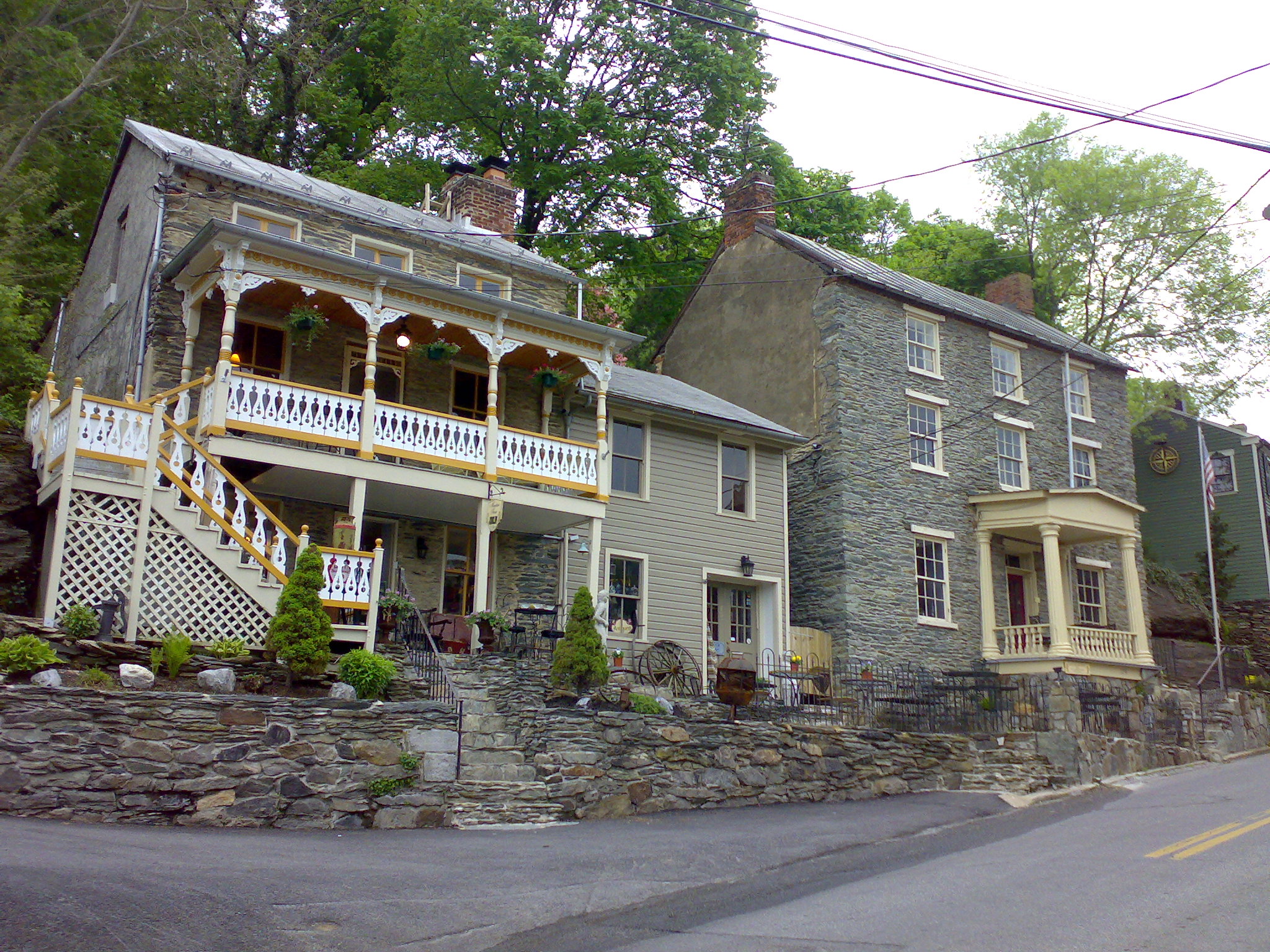
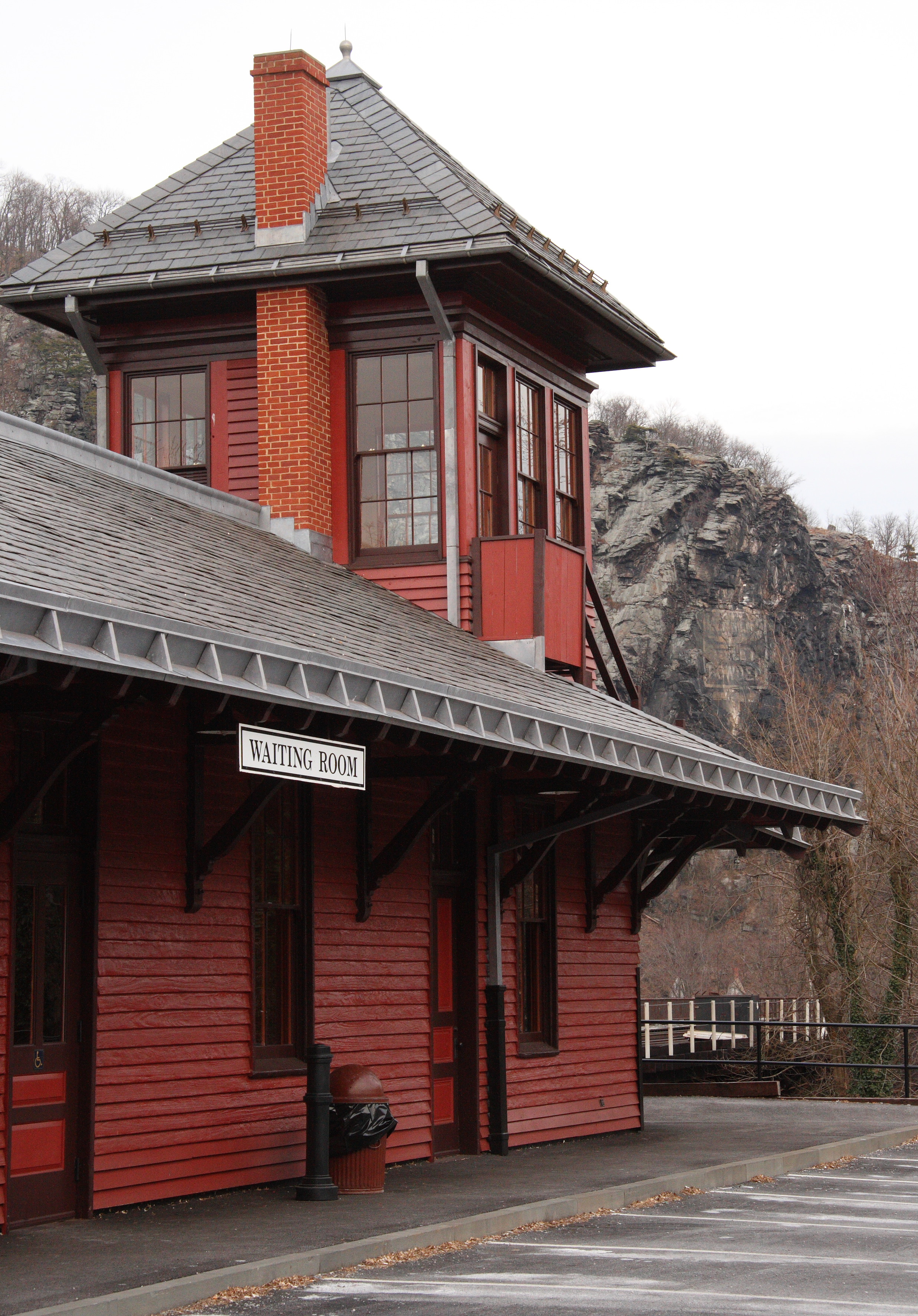
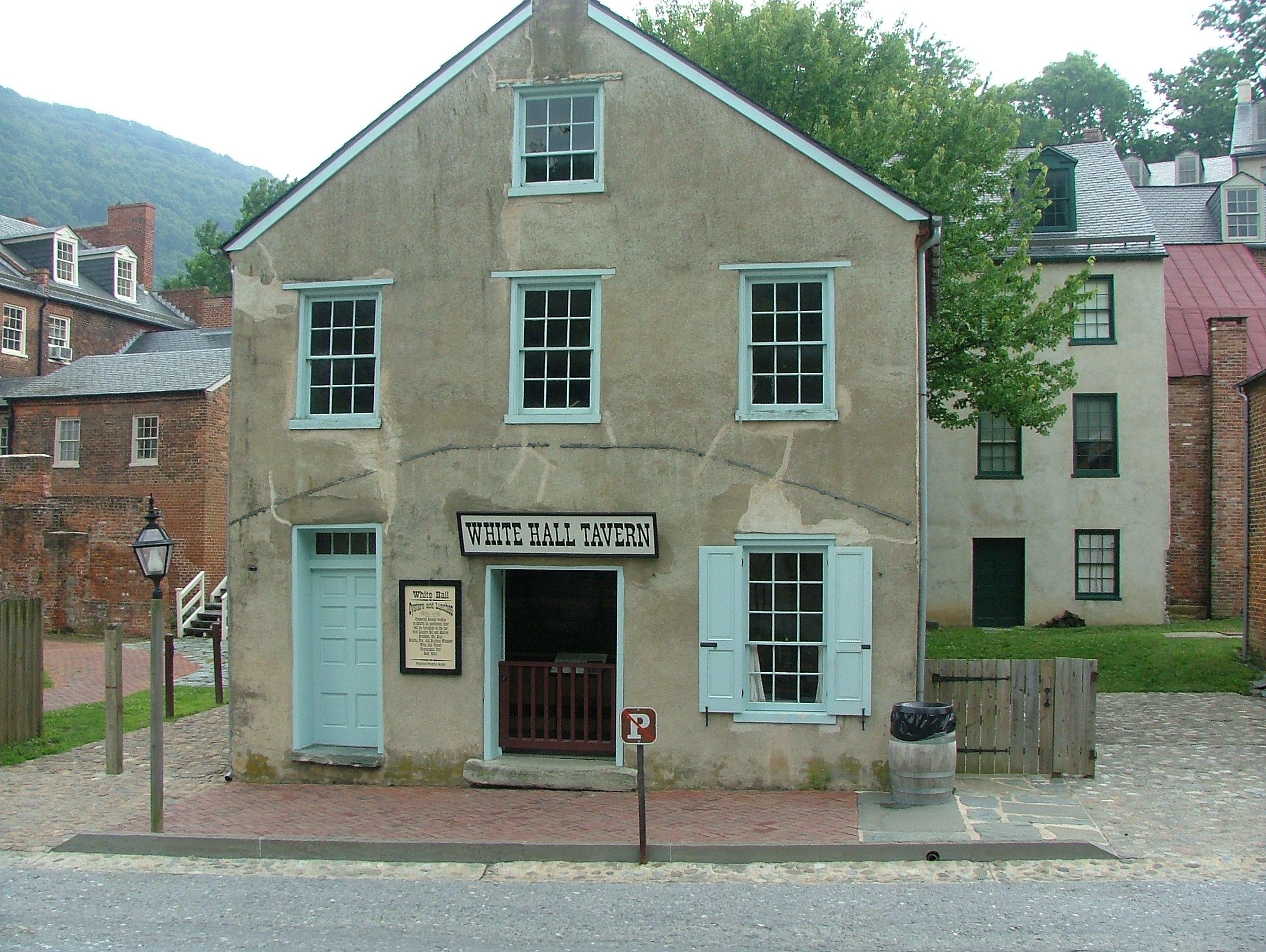
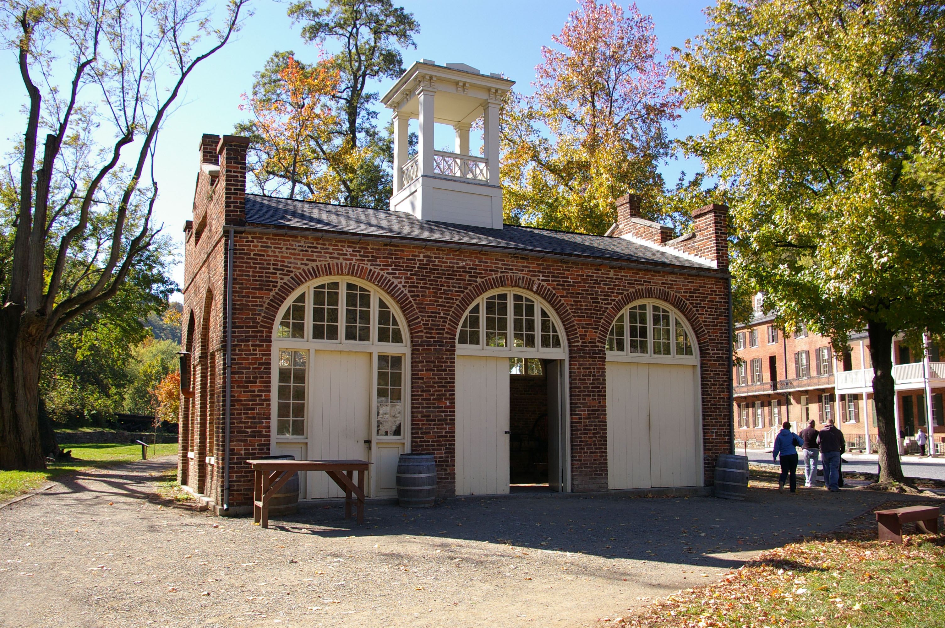
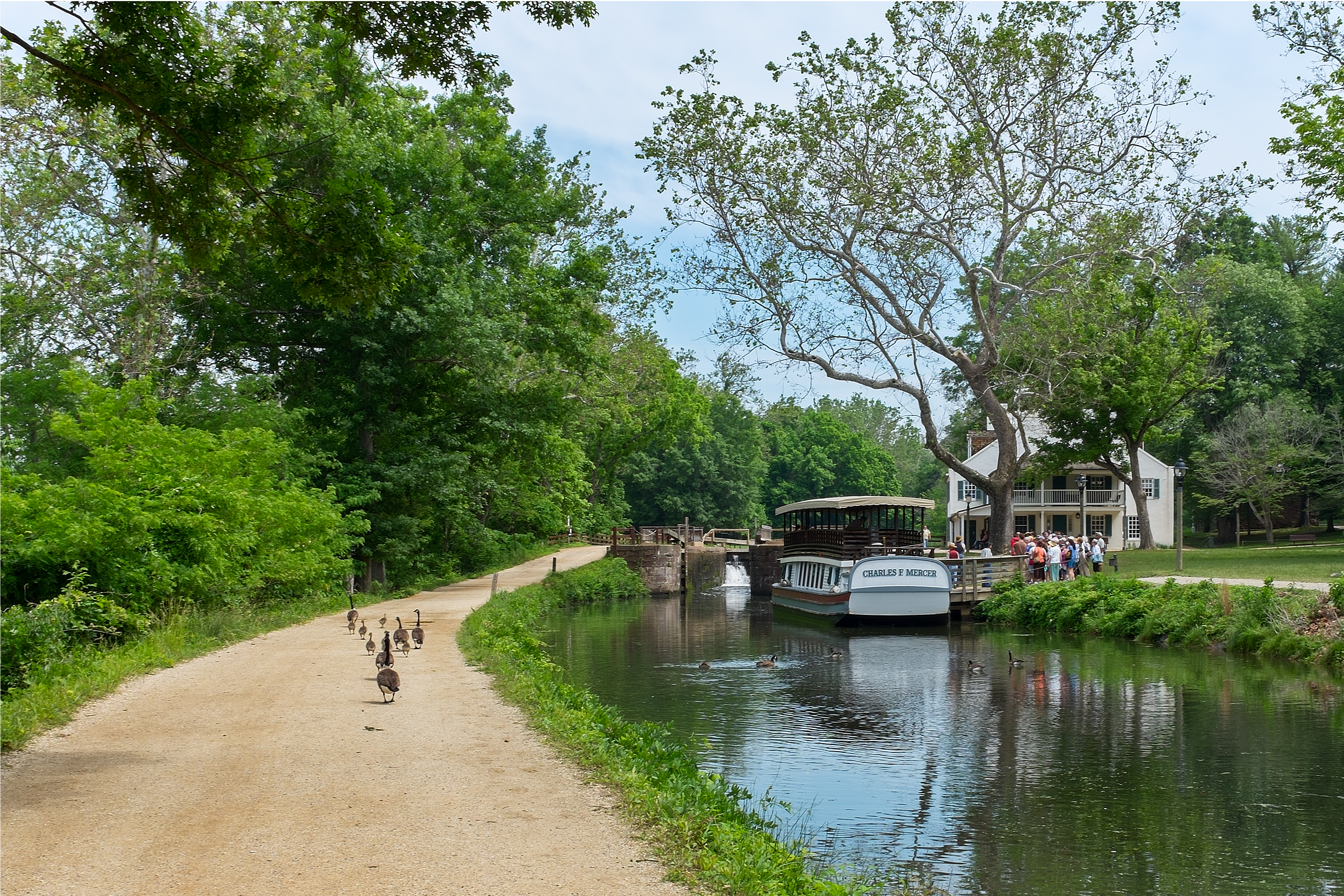
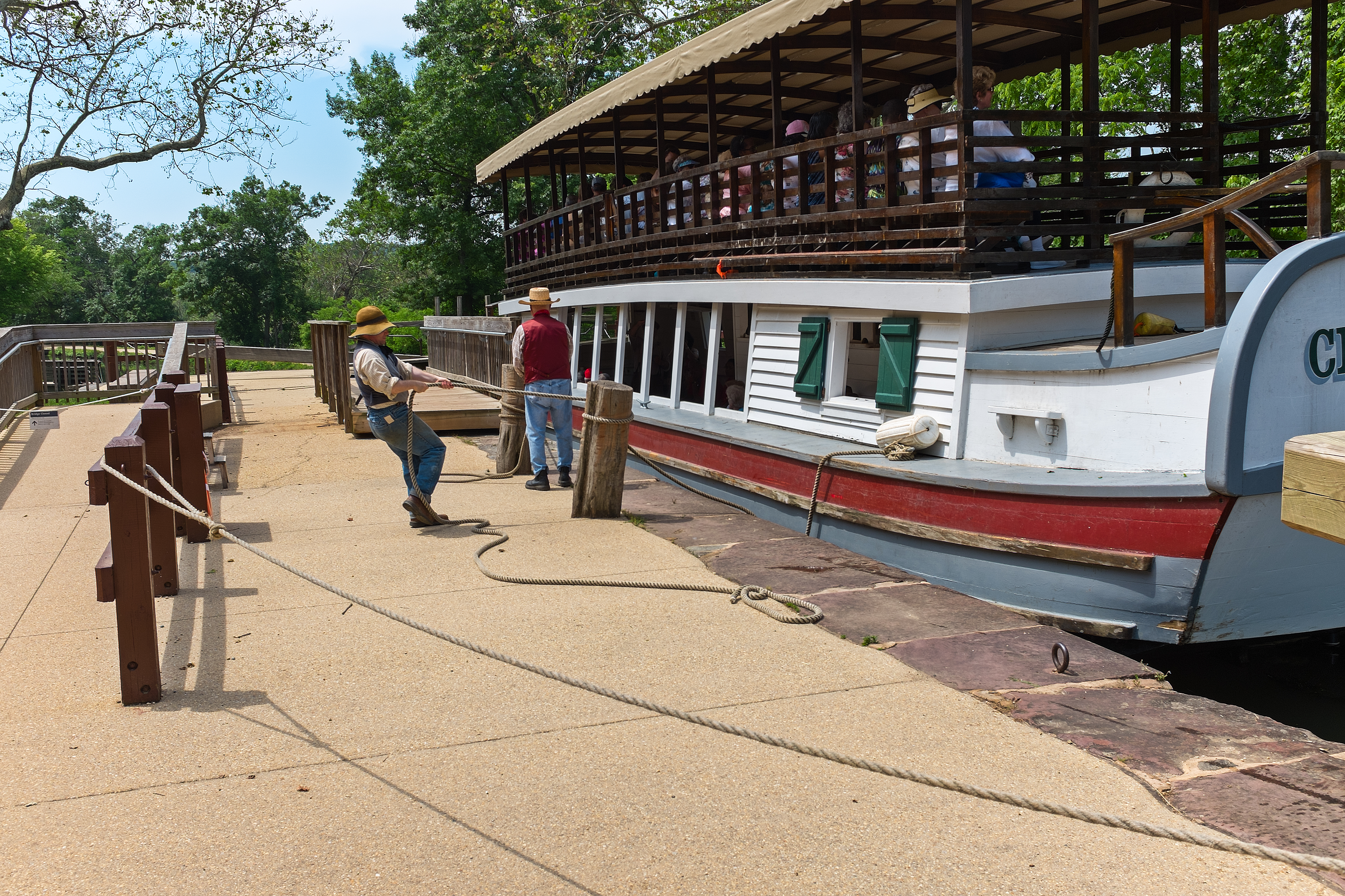
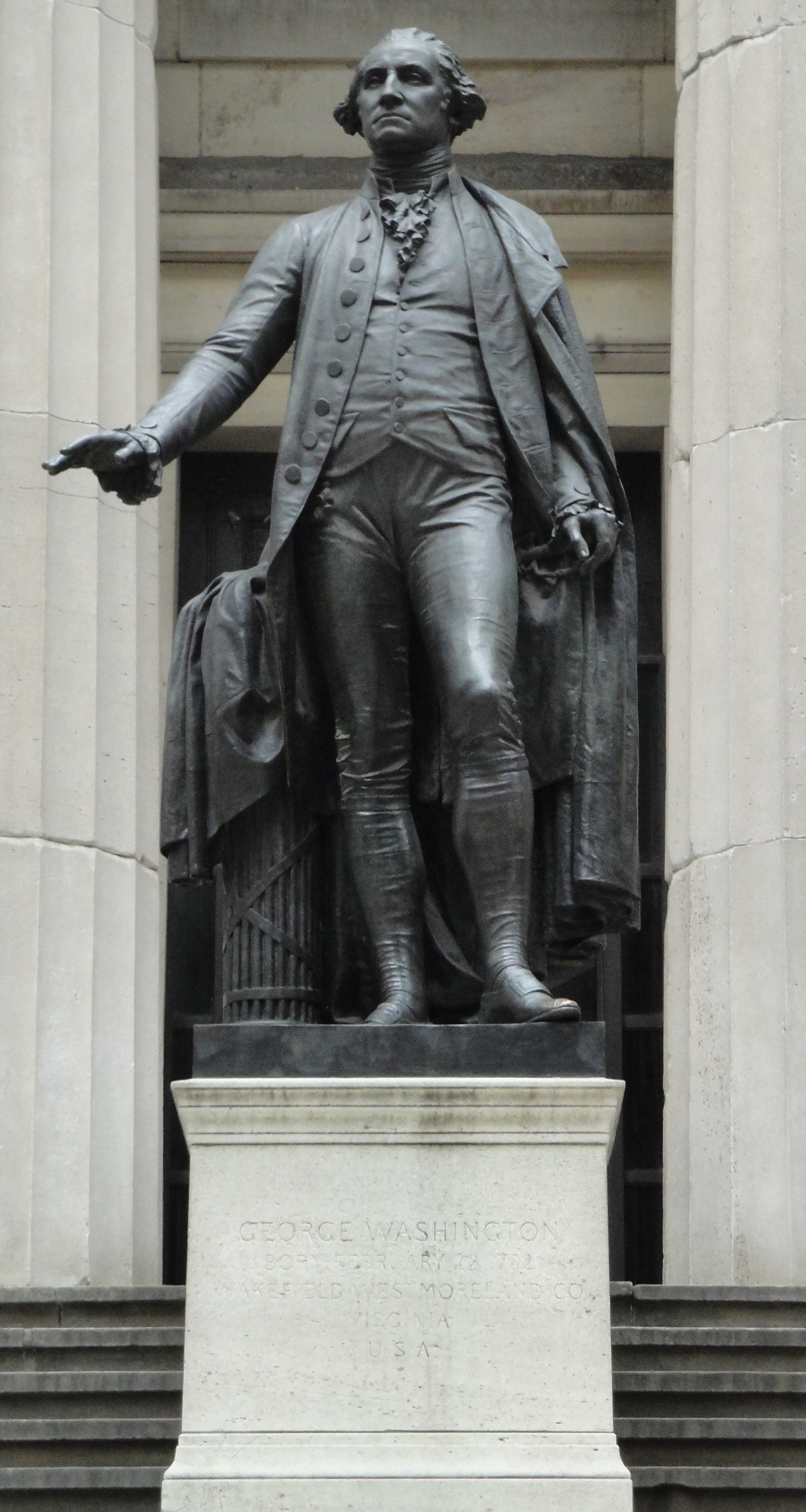
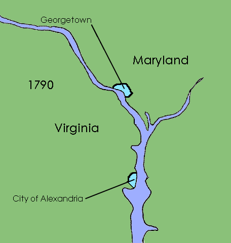
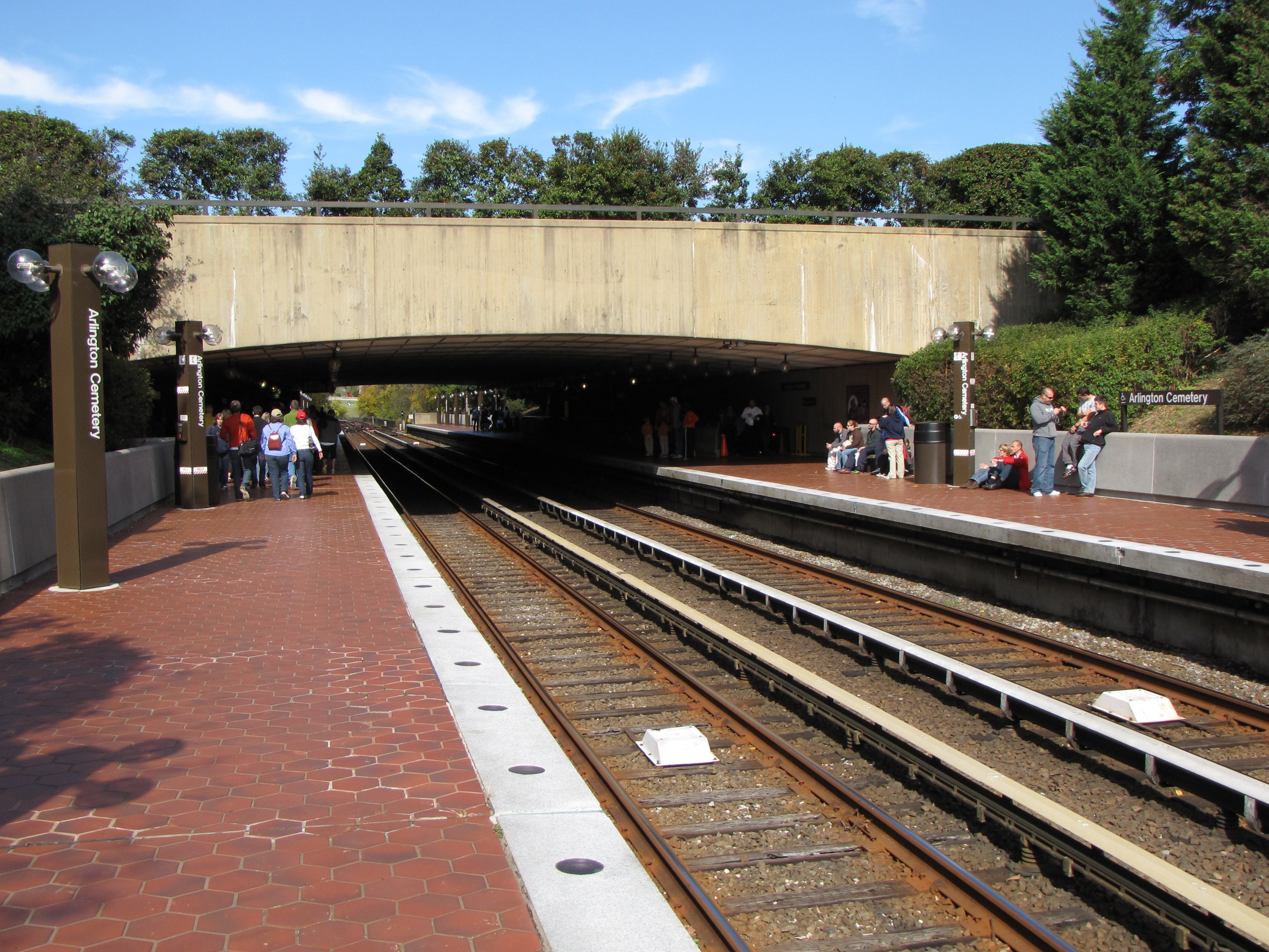
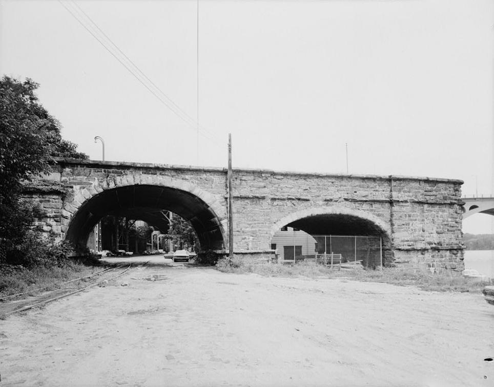
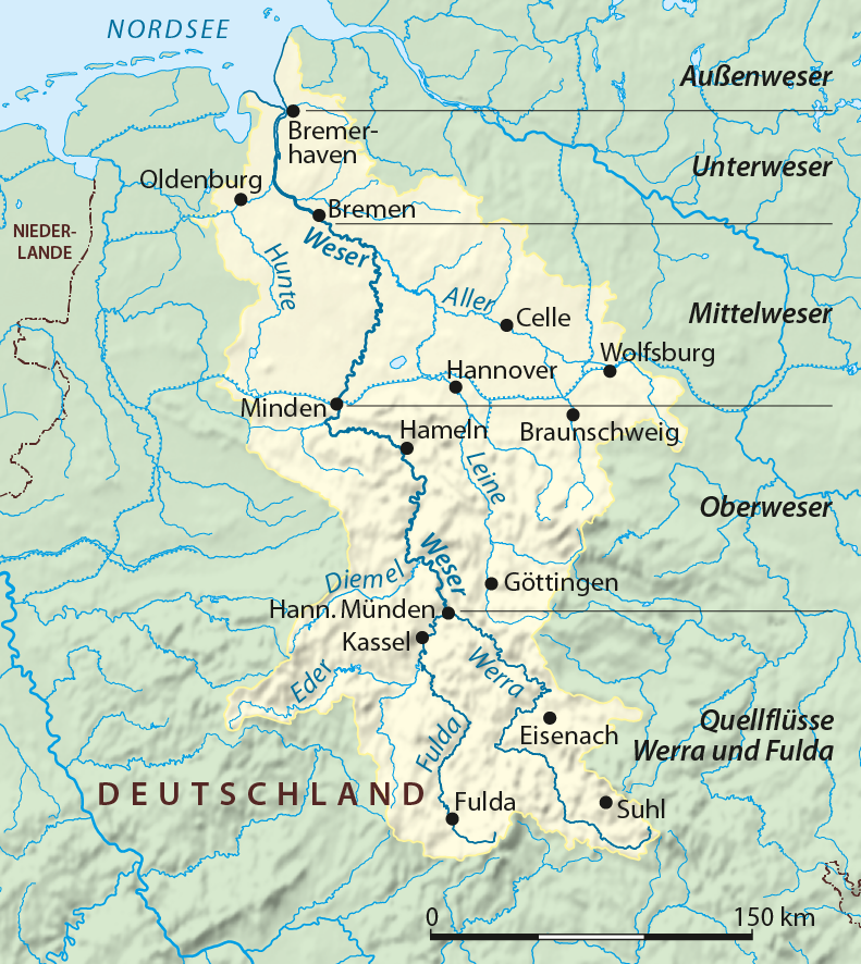