|
Reflections 2016
Series 13
September 3
East Coast IV: C&O Canal–Antietam-Harpers Ferry Area
| | Day 5: C&O Canal, Antietam, Arrive Harpers Ferry Leaving Gettysburg, we continue on this side trip inland by leaving Gettysburg down along the route to the southwest that, by chance, Lee and his army used in retreat from the Battle. Once again, we'll provide below, for reference, the Maryland map and the Maryland rail map, although the latter continues to be more helpful, even for non-rail matters:
http://www.ezilon.com/maps/images/usa/maryland-physical-map.gif
http://www.mdot.maryland.gov/newMDOT/Freight/Documents/railmap.pdf
| | | | We're headed back into Maryland from this short interlude in Pennsylvania, in the direction of Hagerstown. While still in PA, we see a side road leading to a covered bridge, visible from our road, which is an charming advantage of traveling back roads. | | | | The game plan is this: we're going to visit the C&O Canal end-to-end going downstream, that is, from Cumberland to Georgetown. Let's first review what we know, and then extend it a bit. We saw in 2016/12 how the C&O Canal and the B&O railroad were formally initiated on the same day, 4 July 1828, with the canal getting the rights to the north bank of the Potomac in Maryland. The railroad route also started out on that north bank, but crossed over to the south bank at Harpers Ferry, rather spectacularly, into what was then Virginia, and is today West Virginia. It then stayed on the south bank, crossing back into Maryland only at the last minute, at Cumberland. The railroad arrived at Cumberland first, with the canal getting there fully eight years later, in 1850. It was decided then that the canal would not go any further on the planned route to Pittsburgh on the Ohio River, in spite of the fact that "Ohio" is part of the Chesapeake & Ohio name. This left the canal to operate just locally in Maryland. It did so for close to a century, from 1828 to 1924, when a Potomac flood ruined it, and it was closed down. Its primary use turned out to be to transport coal from the Allegheny Mountains to Washington. | | | | We'll reproduce here the map we saw in the past of the C&O Canal, showing the completed portion, plus what would have been the Pennsylvania extension that was never built. The completed portion runs 297 km (184.5 mi) between Cumberland and Georgetown, in Washington. I find it ironic that, when I was on the Capitol Limited, it made nighttime stops after Cumberland in Connellsville, then Pittsburgh, just where the canal would have gone. | | | | It was only on this trip that I actually realized the nature of this canal. It didn't run off by itself overland somewhere, but constantly stalked the Potomac. It was "of" the river, yet really had little to do with it, other than tapping it for water at places called guard locks (inlet locks) to keep the regular locks filled. Just as you'd build a road or railroad along a riverbank, this canal was also built along the riverbank. How odd to have two parallel waterways so close together, yet how attractive it is. Of course, it was the treacherous flooding of its close neighbor, the Potomac, that did the canal in. | | | | To get a feeling of what the canal was like in its heyday, we can look at some period photographs. This first one, taken between 1900 and 1920, is in Cumberland, the western terminus, and shows canal boats being loaded with coal (click) from coal hopper railroad cars coming from West Virginia. The boats riding low in the water have already been loaded. This next view, taken after 1909, shows a boat being towed along the canal route (Photo by Herbert E French). The tow rope is visible, although the mule isn't. Here a boat enters a lock in 1912 (click). Finally, in a picture taken just before or after the Civil War, these are mules being fed by a canal worker alongside a boat in the canal. | | | | If you understand how the canal runs along the riverbank and is set back slightly from it, you can properly picture the mid 20C proposal to turn the disused canal into a highway for cars. A riverside canal would then become a riverside parkway. But that proposed solution infuriated many, most notably US Supreme Court Associate Justice William O Douglas. Unusual as it is for Supreme Court judges to become activists, Douglas, who was an outdoorsman and environmentalist, championed the effort to establish the canal's right-of-way as a national park and is credited with saving the disused canal for posterity. The Washington Post had published editorials supporting Congress's plan to fill in and pave the canal, and so he famously challenged its editorial board to hike the length of the canal with him. In March 1954, Douglas led an eight-day hike of the towpath from Cumberland to Georgetown, in the very direction we're driving—not hiking—in. While 58 people participated in bits and pieces of the hike, only nine men, including Douglas, hiked the full distance. These efforts convinced the editorial board to change its opinion. He then formed a committee that drafted plans to preserve and protect the canal, which was ultimately successful. In recognition of his efforts, a bust of Douglas was erected at Lock 3 in Georgetown in 1977 (he died three years later), and I visited the attractive bust on this trip. The below picture shows his wife, Cathy Douglas, at the time of the dedication:
http://lenapedelawarehistory.net/mirror/PHOTOS/WODouglasBust.jpg
| | | | So it begs the question: how can we visit the canal? Ideally, it would be to take a boat ride along its full length, as we did on the Rideau Canal in Canada (2014/16) or the Göta Kanal in Sweden (2006/8). But the C&O was never repaired after the flood that killed it and is mostly dry, other than selected sections that the Park Service had re-watered. (I loved that word since the first time I heard its use in reference to the canal! I wish I had more occasion to use it.) The next choice is to hike its length along the towpath, as Douglas did, or as present hikers and bikers still do regularly. That's the way to see every last little "bump in the road" as it were. But I'm not a hiker, and I also don't need to see every last thing. | | | | So the answer is to drive the length of the canal on nearby roads and make stops one has read about as being the most interesting. Even driving, I didn't stop at, say, every lock along the way, which are numbered from 75 near Cumberland down to 1 in Georgetown, plus a Lock 0. To my mind, that would be overkill. But I selected nine locations as Canal Stops that are special enough to visit, and I'll number them in my own order. | | | | On our ever-helpful rail map, we can also check out roads. We had reached Hagerstown MD above, where we can get on the interstate to zip us out to Cumberland to start out, since there's a lot to do, and we'll get back to our smaller roads as we go down the canal—and Potomac. You see how I-70 gets us next to Hancock in the wasp waist, but then it flips north into PA. Not to worry, since I-68 takes over westbound, crossing the odd mountain pass on the way to Cumberland.
https://www.nps.gov/choh/planyourvisit/upload/CHOHmap-full-140922-v7.pdf
| | | | This is the excellent National Park Service (NPS) map of the C&O Canal National Historical Park (NHP). At the top, click the (+) three times to bring it up to 150%, which is comfortable for viewing what we'll be doing. While we again have a tilted map with north roughly on the right, it makes good sense for this map to be this way, and we can read it as a scroll, top to bottom. So find Cumberland, now at the top, and the Visitor Center at the Canal Terminus at the Canal Place State Heritage Area, which includes Guard lock #8. | | | | Canal Stop # 1: Cumberland At the outset of this trip, I said there were two disappointments. The first was in Wilmington and not being able to get close to the historic Swedish locations, although in retrospect, once I wrote it up, it really wasn't so bad. My second instance of disappointment and frustration was in Cumberland. I knew the canal scene there was combined with a historic railroad station, but when I got there, it was all confusion as to what was where, with no maps available, which I rely on heavily to show myself around. Perhaps, unusually, I wasn't properly prepared. I saw lots of things in the hour I was there, but left frustrated at not seeing the big picture. Well, once again, a lot happens in the "after-trip", this time of writing up, and further researching, the location. I will readily admit that I learned a lot during this writeup, and happily, it all makes sense to me now, and the collection of maps and pictures I have make everything I saw fall properly into place. However, I do see that this area has been changed drastically and is almost unrecognizable compared to how it was during the canal's operating days. | | | | I had armed myself with this historic map of the Canal Terminus at the Cumberland Basin in the mid-1890s (Map by Bonnachoven), and we can use it to get oriented. At this point, the Potomac enters from the west on the left and leaves at the bottom to the south. Wills Creek is important, since, if the canal had continued, it would have left the Potomac for the first time ever at this point and would have continued north up the side of Wills Creek into PA. | | | | On this map, disregard the interstate and rail tracks and just look at the parts of the canal. This is what I was expecting to find, since in most places the canal remains, although dry, and sometimes in ruins. This is not what I found, which was part of my confusion. Frankly, remove almost all the canal infrastructure you see, which you saw in the above photo where boats were being loaded with coal. See if you can find the very fine yellow dashed lines that encircle Guard Lock #8—and just that. That is all that's left from the original canal. Then follow those yellow lines south to where it mentions the modern basin. In other words, a long pool has been built to give the feel of the canal terminus, which in reality has disappeared, other than for Guard Lock #8. I can only guess it involved needing the land along the river for something like a rail or flood embankment. Perhaps you can understand my original disappointment, although now I'm much more accepting of what I saw.
http://www.satelliteview.co/?e=39.64972,-78.765:0:Riverside%20Park%20-%20Cumberland%2C%20Maryland:map:0
| | | | Now let's visit Cumberland together and it will be quite enjoyable, despite a light drizzle, almost a mist. I've found this excellent satellite view. Hit the (-) just once to go up a level. You can also flip it between satellite and map. Try both. | | | | We arrive down I-68 from the right and easily spot the ex-B&O tracks that Amtrak uses, along with the Amtrak Station, where the Capitol Limited stopped that night after dark. We take exit 43B on the north side of the interstate, where it's only a couple of blocks to Canal Street, with our goal on the west side. What had been confusing is that this river area north and south of the interstate is now called Canal Place State Heritage Area, which includes several things, most notably the canal terminus area and a historic rail station. | | | | With our back to the interstate overpass, this view looks north over the station plaza (Photo by Bonnachoven) and Canal Street, which means the modern canal basin is also behind us. The tiles we're standing on are on the towpath of the canal, as it ended a little north of the basin. The red brick building is the plaza façade of the former Western Maryland Railway Station, on the National Register of Historic Places, which also contains the Cumberland Visitor center for the C&O Canal NHP. The tracks are on the upper level behind the building. Click to inspect the fountain and statue of a boy leading a mule on the towpath, of which this is a clearer detail:
http://www.canaltrust.org/wp-content/uploads/2015/05/Mule-Statue-at-Canal-Place-Tina-Yoder-1024x768.jpg
| | | | We go into the station and upstairs to the track level (Photo by Caseyjonz), and cross over to Wills Creek, as we look south to the interstate and modern basin. The Western Maryland Railway (WM) (Map by Caseyjonz), shown here in the 1950s as it reached into WV and PA (Gettysburg) as well as Baltimore, was primarily a coal-hauling operation with a small passenger service. Many of its lines were abandoned in the 1970s in favor of parallel B&O lines, which it duplicated, and eventually became a part of B&O (now CSX). We see even now the duplication in Cumberland with the two stations. This station was built in 1913 and was a passenger station until service ended in 1959. But it still has some passenger service in the form of the Western Maryland Scenic Railroad, a heritage railway that offers three-hour round trips steam tours from here west to Frostburg (see rail map "WMSR"). | | | | We crossed over the station area to get a better view of Wills Creek. Still looking south, click to see the rail station we just were at, and then the Potomac straight ahead. Beyond the interstate bridge is a small, curved pedestrian bridge that it was suggested I cross from the far end of the station to get a better view of the Potomac from a park on the other side, which I did. I've now learned that Wills Creek had been notorious for flooding Cumberland, and in the 1950s, the US Army Corps of Engineers built a successful flood-control system that involved pumps, paving the riverbed and building concrete walls along the riverbanks, visible in the picture.
| | | | Let's go back to the station plaza and turn around, looking south. This is a replica of the Cumberland, a canal boat. (Photo by Bonnachoven). Click to see the wall around the modern canal basin in the background. | | | | Check again on our map that, when you pass the interstate to the south, you see the toothbrush-shaped modern basin (Photo by Bonnachoven), here looking south, or downstream. My guess is that that berm on the right is where the actual Cumberland Basin was, long gone. But when we turn around and look north (upstream) (Photo by Bonnachoven), we get a view of almost everything. Click to see beyond the interstate the station plaza with the fountain, the rail station with platforms, and the curved pedestrian bridge I'd used. But more important, look to the left at the end of the pool to see what's left of Guard Lock #8, which led to the Potomac out of sight to the left and allowed for the intake of water for the canal. Also note the little white stone marker.
http://4.bp.blogspot.com/-cBJXEok3r34/U8cZ4YAms-I/AAAAAAAAAy8/7B-HjYWXxNI/s1600/IMG_8794.JPG
| | | | Here's the marker close up. This is the highest mile marker on the canal, at 184.5 mi (297 km), and our goal is Mile 0 in Georgetown. Unfortunately, the photographer also wanted to show off his bike. | | | | Finally, go back to our satellite view and come down close on all this area, and you'll see everything, even the fountain in the station plaza. Also note, near the little bridge I crossed, what Guard Lock #8 looks like, even though it's no longer connected. A guard lock regulated water entering the canal, and is also called an inlet lock or feeder lock. There were seven, numbered 1-6, plus 8, skipping 7, and so Guard Lock #8 was the first water intake of the entire canal. | | | | On the NPS map, the green line is the towpath. If you want to hike or bike its entire length so as to see every last thing, lotsa luck. Otherwise, let's start out by driving down highway 51, which stays close to the route, and actually adjoining it at some spots, but which will also bring us to our next stop, the Paw Paw Tunnel. | | | | Canal Stop # 2: Paw Paw Tunnel Now coming across that name brings up two questions, about the name, and about the tunnel, so we'll take them one at a time. What does paw paw mean? Well, the tunnel on the MD side is named after the town of Paw Paw on what was the VA side, now WV. The Paw Paw bends in the Potomac also are named for the town (see NPS map). So where did the town get its name? Many might be familiar with the tropical fruit named the papaya that comes from a tree of the same name, native to southern Mexico and Central America. The pawpaw is a related temperate tree native to the eastern US, whose name is probably derived from the Spanish name papaya, due to a similar appearance. The pawpaw fruit, which is usually 7–12 cm (2.8–4.7 in) long, is the largest
edible fruit native to the US (Photo by Manuel.conde). (The fruit and tree are each written as one word, and related place names as two) Pawpaw trees grow prolifically along nearby ridges, giving their name to the town, and therefore to the river bends and tunnel.
http://www.bikewashington.org/canal/maps/map_l.png
| | | | As for the need for the tunnel, consult the NPS map, or even better, this detail. There are two places where the Potomac wanders off in loops to do its own thing, and the canal builders thought it foolish to slavishly follow the river, and the Paw Paw bends were one of them. In addition, there's a mountain in the way here, and the north riverbank along the bends is hilly, with no room for a canal anyway. So the builders decided to solve the problem by building a tunnel, connecting with the canal at both ends. The tunnel is almost 950 m (3,118 ft) long, or almost 1 km (0.6 mi), and bypasses the 9.7 km (6 mi) length of the Paw Paw Bends. It was built between 1846 and 1850, and is the largest structure on the canal. It always had high traffic, the regulation of which was always a problem. | | | | On the detail map, just before route 51 crosses the river into WV to become highway 9 (the red line is the towpath), there's turnoff for a campground and picnic area. The light misting drizzle has continued from Cumberland, so as we park and step along the very short access trail to the towpath, we remain armed with an umbrella, though it's not really needed that much. It's about a 20-minute stroll through the woods to the tunnel. The river is no longer in sight, of course, but the watered canal, somewhat weedy at this point, is on our left. The tunnel is a popular destination, and we greet people coming and going. | | | | As we approach the south portal of the tunnel (Photo by Michael Kreiser) we see here the canal behind the trees (click), and also the beginning of Tunnel Hill Trail on the right that goes over the mountain (see detail map). The tunnel is straight, so all views into it show the exit at the other end. The towpath we're on enters it on the right, with a wooden fence along its left side. | | | | As we get really close (Photo by Brian M Powell), the actual practicality of the situation presents itself clearly. All the literature one reads in advance warns the visitor that the tunnel is dark and dank, and that one should bring a flashlight to walk its length, and sturdy shoes. That probably would work for a local visitor on a day trip, but I wasn't about to carry a flashlight during this whole trip along the East Coast. Also, this picture shows the puddles accurately, easy to step around. But after walking about fifteen steps into the tunnel, and holding on to the railing for dear life, it becomes obvious that there's enough water seepage coming through the walls that the towpath within the tunnel is muddy and slippery, quite a bit worse than outside. I hear someone in the distance far into the tunnel, and someone else is walking his bicycle into the tunnel ahead of me. But caution wins the day, and seeing the tunnel without walking its full length is enough to check it off my bucket list.
http://takemytrip.com/images/448_DSC01440.jpg
| | | | This picture is excellent, but misleading. It was obviously taken with a flash, so the tunnel looks inviting, even cozy. Just remember, as you look at the picture, you're not slipping and sliding on the muddy towpath. And if curiosity overtakes you about that light at the end of the tunnel, this is the north portal (Photo by Michael Kreiser), which looks much like the south one. I will say, though, that this view does look like it was taken on a drier day. | | | | Canal Stop # 3: Hancock & the Wasp Waist On the main NPS map, you'll notice how impractical it is to try to cling to the canal through this mountainous area, and so we cross the Potomac into WV and take route 9 via Paw Paw to Berkeley Springs, where 522 gets us to Hancock MD, where we're at the narrowest part of the state, its "wasp waist". And here I have to modify very slightly an earlier assertion. Look back at the rail map. When we were on the Capitol Limited, the ex-B&O rail line Amtrak uses spectacularly leaves MD out of a tunnel to enter WV at Harpers Ferry, our destination today. As it got dark, I was aware it remained in WV for Martinsburg, but knew that its following stop, Cumberland was in MD, so I assumed we crossed back rather promptly. Not so. Follow how the rail line (in green) stays in WV quite consistently, and enters MD only at the last minute for Cumberland.
http://www.landsat.com/town-aerial-map/maryland/map/hancock-md-2436600.jpg
| | | | So stating that all routes go through the wasp waist has to be slightly modified to include the rail line, and so all routes go through, or adjacent to and along, the wasp waist. Follow that on the above Hancock map. From south to north, the B&O rail line in WV, then the Potomac, a block north of that is the C&O Canal, two blocks north of that, on Main Street, is the National Road, and above that is I-70, swinging into PA, with I-68 continuing west—well, we're back to where we were this morning, aren't we? | | | | I'd checked it out way back when making these plans, and now executed the following tiny detour. From the bridge, we turn right on Main Street, then left on the very aptly named Pennsylvania Avenue, and before you know it, we cross the Mason-Dixon line with a sign welcoming us to PA. This border-to-border width of MD is only 2.9 km (1.8 mi), and it took us under three minutes to cross it, having been in WV, MD, and PA in that time. Of course we crossed the Mason-Dixon Line earlier, going to and from Gettysburg—the latter just this morning—but the border wasn't marked either time on those back roads. This time we knew just where we crossed it. | | | | Coming back into Hancock, we cross Main Street and in two short blocks we're at one of the prettiest stretches of the C&O Canal, right here in Hancock--obviously re-watered. This view has to be to the east, since the towpath is on the right—the Potomac would be visible through the trees further to the right. Note that street with the stop sign, Canal Street. When we turn around facing west, we have this view along Canal Street (Both photos by Aude).
| | | | We said the National Road had become US 40, but when that was shifted (in this case to I-70/68), the road was then called MD-144, and we drove that, under the name of Frederick Road, from Baltimore into Ellicott City. Hancock is another area where the National Road is to be found, again under the MD-144 designation. On the Hancock map it comes in from the west, and we take it as it becomes Main Street and then East Main Street—and then gets swallowed up by the interstate! East Main Street, as you can see, runs right into an on-ramp for I-70, so we have no choice, but that's fine. | | | | Canal Stop # 4: Four Locks Check the NPS map to see that we get off at Big Pool on highway 56. We then come to a quaint back road and drive through a narrow, one-way tunnel under a former rail line, pass a ramshackle building that I'd read earlier used to be a schoolhouse, and arrive at the peaceful, lush green ghost town that used to be the town of Four Locks. Check on the map that these had been locks 47-50 and also that this is the second place where the Potomac makes a huge loop, giving MD a peninsula protruding into WV. Therefore, after Paw Paw, this is the second place where the canal deviated from the river.
http://mcmullans.org/canal/Maps/Four%20Locks.jpg
| | | | This shows the area. The state line is in yellow, WV is to the south, MD (and the entire Potomac, as you know) is to the north. Looking downstream, we find Guard Lock #5, meaning that, back in the day, this was another spot where the Potomac was tapped for water for the canal. You see the rail line under which we ducked from highway 56, and then the dotted brown line, which is the trail along the towpath, in other words, the route of the canal, with the four empty locks. Neither the canal nor the locks here are watered. | | | | To avoid that peninsula, no tunnel was needed as in Paw Paw, since there was no mountain in the way. But the 6.4 km (4 mi) section of the river that was skipped dropped 10 m (33 ft) in elevation, meaning a series of four locks in a row was needed to make the canal correspond to the change. These four locks were built in 1836-1838. | | | | This panorama shows the idyllic, lush scene today at the former town (ghost town) of Four Locks (Photo by Bonnachoven), taken from the berm along the canal here. Click, then pan and scan, to inspect Lock 50 with its small watch house on the right, Lock 49 on the left, with Locks 48 and 47 visible in the distance on the left. It's so quiet and idyllic that it's hard to imagine the town of Four Locks on this very spot once being a thriving 19C community of houses and businesses, all related to the canal and its business. Once the canal closed in 1924, since the town was totally dependent on the canal, it quickly declined, although this area was used for recreational purposes until the mid-1950s. | | | | The community in its heyday had about a dozen houses, two stores, two warehouses, a post office, a dry dock for boat repair, and a school. Well, we passed the decrepit schoolhouse driving in, and this period photo shows Lock 47 with its dry dock in the foreground. | | | | I've read that the canal builders considered every canal structure a work of art, and that becomes apparent when observing the careful stonework at the tunnel, on bridges, and in the locks, empty and grass-filled as they may be--this is a close-up of
Lock 48. Let's take a walk up the hill to Lock 49, a view that includes the Lockkeeper's House (click), which is fully restored and rented out by the NPS to anyone wanting to vacation in a historic house in the woods and who is willing to rent the whole thing. We finally come to Lock 50 with its watch house shanty. At the far end, if we turn around, we can look down the hill from Lock 50 and its shanty to (click) 49 and its Lockkeeper's House and even a bit of 48. This is a good point to inspect the protective berm at the left that we saw in the panorama, then the canal, then the towpath on the right. And not another human being in sight the whole time we're there (All four photos by Bonnachoven).
| | | | When we leave, we duck through a second narrow tunnel under the rail line (see local map) back to route 56. We connect to 68 (see NPS map) and along the way, pass over a charming, narrow humpback bridge and on to our next stop, Williamsport.
http://www.bikewashington.org/canal/maps/map_h.png
| | | | Canal Stop # 5: Williamsport This detail map (click) shows how 68 brings us into Williamsport from the north, and also how Williamsport is more of a small city than some of the places we've been visiting, having grown with the canal. As we come down the main N-S street, even for the short period of our visit, the handsome nature of the local architecture is striking (Photo by Tim Kiser). Follow-up research shows that the historic core of the town forms the Williamsport Historic District, a national historic district, where almost 20% of the buildings date from the late 18C and early 19C and slightly less than 60% from the late 19C (many Italianate and Queen Anne-style buildings, both residential and commercial) and early 20C. | | | | Also note on our detail map how close Hagerstown is. We talked in Gettysburg about how Lee and his army retreated in the direction of Hagerstown in 1863. We can now add that they continued to Williamsport to cross the Potomac back into VA (today WV), but it was flooding, and prevented them from continuing for several days. Still, they nevertheless avoided the (slowly) pursuing Union Army.
http://www.canaltrust.org/wp-content/uploads/2015/05/Williamsport-Visitor-Center-John-Gensor1-600x403.jpg
| | | | On our map, you'll see how a right turn onto the main E-W street gets us down to the canal, whose towpath is in red, just before the Potomac. But the sight there at first (picture above) looks unprepossessing. We come down that street on the right and THIS is what we see? We have to learn to have respect for our elders. The Cushwa Warehouse predates the canal. It was built between 1790 and 1810, and when the canal arrived, the canal came to meet the warehouse, not vice versa! It was a warehouse until the 1970s, and now serves as the local Visitor Center for the historical park. | | | | Obviously, this section of the canal is another one that is rewatered. Note all the space in the canal in front of the building. This is the Cushwa Basin, making Williamsport one of only a few places on the canal where cargo boats could completely turn around. This picture of a steamboat being loaded with coal near Williamsport was taken about 1875-1880. | | | | One other site just a few steps south of the Cushwa Warehouse is the lift bridge over the canal (Photo by Bonnachoven). We talked recently about lift bridges in Stillwater MN and in Chesapeake City MD, previous to the present bridge. Here, trains would cross the bridge, and when canal boats arrived, the center portion would lift like an elevator so they, too could pass. The obvious irony here is that now, neither the bridge or canal is used, making this, shall we call it, a "ghost intersection". But the greater irony is that the Western Maryland Railway built the bridge in 1923, and in 1924, the canal closed because of flooding, making the bridge totally unnecessary. | | | | On our NPS map, but even better on the Williamsport map, when we leave town to the south, 63 takes us to 65, which then takes us to a non-canal stop, Antietam National Battlefield.
http://www.bikewashington.org/canal/maps/map_g.png
| | | | Antietam National Battlefield I wasn't planning to add additional Civil War sites, but I knew in advance that this location right on our route would just fall into our lap, and that we'd have time for a quick stop. And you'll spot on the above local map a surprising thing. The battle was fought on the very route 65 we're coming south on. Look carefully at the red line going up to the Visitor Center. That was the original road, and since then, route 65 has been rerouted in a western loop around the park. | | | | Keep in mind two events we discussed in the last posting of what happened in Maryland a year BEFORE Gettysburg: The Battle of Harpers Ferry took place in 1862 (12-15 September) . . . . Two days later, the war moved for the first time onto definitive Union territory, the border state of Maryland, with the Battle of Antietam . . . on the 17 September. So we're moving backwards in time by one year. We visited Gettysburg for Lee's second foray north, and now we're in the year before, 1862 when he moves over two days from Harpers Ferry to Antietam. | | | | Let's understand the naming. "Antietam" is stressed on the middle syllable and rhymes with "beat 'em". The battle is named after Antietam Creek, which runs along the east side of the battlefield site, and is crossed by a beautiful stone bridge, now called Burnside's Bridge, which was the site of major conflict. The creek meets the Potomac some distance to the south, where there is actually a village named Antietam. It was usually the custom of the Union side to name battlefields after waterways, hence the name. The Confederates more often used town names, so they tended to refer to this as the Battle of Sharpsburg instead (see map), a term that is also still used. This also accounts for several other battles with two names. For instance, the very first battle of the Civil War (there was also a second battle here) was fought southwest of Washington in Manassas VA. It's known both as the Battle of Manassas and, perhaps more frequently, as the Battle of Bull Run, named after a local stream ("run"). | | | | Unlike the three-day Battle of Gettysburg the next year, this Battle was fought in one day, 17 September 1862, and was the first major battle to take place on Union territory. It has the dubious distinction of being the bloodiest single-day battle in American history, with a combined tally of dead, wounded, and missing at 22,717 after twelve hours of savage combat. This overview map of the battle (Map by Hal Jespersen) gives a rough idea of where Lee's and McClellan's sides were located (click). Note for future reference the creek and town, the road we just drove down on, then called Hagerstown Turnpike, the Cornfield surrounded by Woods, nearby Dunker Church, Bloody Lane (the Sunken Road), the iconic Burnside's Bridge, and Harpers Ferry Road. By the end of the day, the Union had routed the Confederates, ending their first invasion of the North. This battle also led to Lincoln's issuance of the Emancipation Proclamation shortly thereafter. | | | | I find battle maps often confusing, so let's now move to this simpler version of the battlefield (Map by Hlj) between town and creek. Curiously, as would later be the case in the three days in Gettysburg, the action started in the north, then moved south, but all on the same day. It began at dawn, when Hooker bombarded Jackson in the Miller cornfield, with the line between them moving back and forth. As that ended, Union forces attacked Confederate troops posted in the Sunken Road (Bloody Lane). Union troops finally took the road after four hours, but the road by then had taken on its nickname. To the southeast, Burnside's troops had been trying to cross the creek all day over what is now called Burnside's Bridge, held back by the Confederates. At about 1 PM, they finally crossed the bridge, and took the heights above it, driving the Confederates back towards the town. But then General Hill's division arrived from Harpers Ferry (apparently along Harpers Ferry Road), preventing Union soldiers from entering Sharpsburg, and having to remain on the heights above the bridge. Fighting stopped overnight, during which Lee retreated over the Potomac, leaving the victory, the battlefield, and the town to McClellan.
| | | | We are going to take the auto tour of the Antietam Battlefield based, as we did in Gettysburg, on an NPS tour map, but this tour is shorter and simpler. We have our usual supply of illustrations, and a couple of period photographs, but I've decided not to use any of the many, many gruesome photographs of battlefield dead that are available online. Instead, I've found a very valuable resource, one that was almost lost twice over the years. Even the story behind this resource is intriguing. | | | | There was a 43-year-old professional artist, a member of the 2nd Vermont Infantry, named Captain James Hope. He'd earlier seen action in a dozen engagements, but at Antietam was disabled by illness, and was assigned to the side lines, to duties as scout and mapmaker. But he also sketched the scenes he witnessed at Antietam, and later converted the sketches into five large paintings, now referred to as the Hope Paintings, giving an on-site veteran's view of the battle. | | | | He first exhibited them in his gallery in Watkins Glen NY, but after he died, the gallery was closed and deteriorated, and the paintings were damaged in a flood. Then an art collector bought them and hung them in the eaves of a church, where they were further damaged by birds and rodents. After these two near losses, the NPS bought them in 1979, and, after carefully removing the 90 kg (200 lb) paintings from the church, where they were fastened by 15 cm (6 in) spikes, brought them in for a painstaking restoration.
https://www.nps.gov/anti/planyourvisit/upload/park%20map.pdf
| | | | On this NPS map, follow our route down highway 65 and again inspect where it used to go, now part of the park, and where it now swerves to avoid the park. Opposite the Visitor Center is the Dunker Church (#1), built in 1852. The Dunkers were a German religious group similar to the Mennonites, Quakers, and Shakers, and the church became a focal point for Union attacks the morning of the battle. The height of irony is, of course, that like the other groups, the Dunkers were strict pacifists. The first Hope Painting, called Artillery Hell, a term coined by a Confederate colonel because of the intensity of the fire. It shows the white Dunker Church on the left. It's still early morning, looking north on the Hagerstown Turnpike. As with most of the Hope Paintings this is not really a single moment in time, but a composite of events. Now as we drive up to the handsome Dunker Church today (Photo by Acroterion), we how very starkly simple and Shaker-like it is, particularly the interior (Photo by Ken Lund), where those simple pews could be in any Shaker building in New England. | | | | The whole northern loop of the drive goes around the Cornfield (#4) and the three woodsy areas near it (#2-3-5). The cornfield saw some of US history's most horrific fighting. Over three hours' time, many regiments on both sides were cut to pieces. A Louisiana Brigade suffered 60% casualties in 30 minutes. In the West Woods, over 2,000 Union soldiers were killed or wounded in 20 minutes. | | | | The Mumma Farm (#6) is the site of the only deliberate destruction of property during the battle, as Confederate troops were told to burn the farm to prevent its use by Union sharpshooters. The Mummas had fled before the battle, and did rebuild their farm the next year. During mid-morning about 10,000 union soldiers advanced across the Mumma and Roulette farms toward the Confederate center at Sunken Road. The second Hope Painting, called A Fateful Turn, looks east in the late morning toward the Roulette Farm (straight ahead), and shows the burning Mumma Farm to the left. With the smoke, noise, and confusion to the north, Union troops turned south (Roulette Farm, #7) toward an old sunken farm lane. The terrain was such that Union troops could not see the Confederate troops hiding down in the lane until they were almost upon them, and suffered a withering fire, the start of a three-hour struggle for control of the lane, which came to be known as Bloody Lane. | | | | Stop #8 is the Sunken Road (Bloody Lane), and the third Hope Painting shows The Aftermath at Bloody Lane at the end of the day, looking east along the 800 meter/yard road. By 1:00 PM, about 5,000 killed or wounded troops from both sides lay along the farm road. The same scene today looking east along the Sunken Road (Photo by Stephen Kellam, cropped & retouched by Peter Fitzgerald) looks much more pastoral and serene, except for some of the many monuments on the battlefield and a stone observation tower in the distance (see park map). | | | | You'll also see the Piper Farm near the Sunken Road and not far from Sharpsburg. While not a regular stop, it was chosen for the fourth Hope Painting, called Wasted Gallantry. Click to see the farmhouse in the middle distance and Sharpsburg beyond, in the late afternoon. The foreground shows the gallant, but futile charge by the 7th Maine Infantry, several hours after the fighting in Bloody Lane. A Union officer had ordered the charge through the Piper cornfield into devastating counterfire from Confederate infantry and artillery. In 20 minutes, the regiment suffered more than 50% casualties, yet the charge did nothing to advance Union lines. It was not unusual for misguided officers on either side to squander the lives of soldiers. | | | | We then move down to the southern, hillier end of the battlefield—you can see we're high enough to cross a bridge at the Sherrick Farm--and find ourselves also high enough to be on an overlook terrace above Antietam Creek and Burnside's Bridge (#9), the southernmost of three that existed at the time (see park map). As we said above, Burnside's troops had been trying to cross it westward all day, but were held back by the Confederates up on these heights. Once they crossed the bridge, they took the heights above it, where we're now standing on the terrace, and started to force the Confederates back toward Sharpsburg. But as we said earlier, a division of reserve Confederate forces arrived from Harpers Ferry, preventing Union forces from entering Sharpsburg—see The Final Attack, #10—and keeping them on the heights above Burnside's Bridge, until the Confederates were gone the next morning. | | | | Burnside's Bridge is the topic of the fifth and final Hope Picture called A Crucial Delay. The reference is to the three hours gained by a small Confederate force on the heights to the west, beyond the bridge, holding the Union forces on the east side of the bridge, so that when they finally did cross the bridge (shown) to the heights and continued toward the town, the reserves had arrived from Harpers Ferry to push them back to these same heights. | | | | While I refrained from showing gruesome period photos of the battleground, we will show a photo of
Burnside's Bridge, described as being taken sometime in the autumn of 1862. My guess is that it's looking west, and that it's most likely after the 17 September battle, but I don't really know. Click to inspect the traffic on the bridge, and don't miss the stylish buggy in the foreground.
| | | | But what do we see today? The bridge, as a work of art, is gorgeous. To see it, you have to go down a trail from the heights (which means climbing up again!), and at first get a view like this (Photo by Stephen Kellam), through the trees. Actually, the bridge was being refurbished, could not be entered upon, and had scaffolding around it, so this nicer than I saw it, though its handsome style shone through. You cannot get enough good pictures of this bridge, so I'll give two more, this one (Photo by Ernest Mettendorf) and also this, my favorite (Photo by Jim Strongin). I was surprised to find out while there that this bridge was in everyday use until 1966,at which time traffic was diverted, leaving it as peaceful as it looks—ironic, given its history.
| | | | One more historic photograph is worth showing, that of Lincoln at Antietam (click) with General McClellan and a group of officers. | | | | On the NPS map, you'll notice that the driving tour leaves the park goes up Harpers Ferry Road and through the town, and then turns back to the Antietam National Cemetery (#11). It's not huge, and the entryway is very Victorian Gothic, as shown by the 1867 gatehouse (Photo by Nicolas Veron). It contains some 4,976 interments (click) (Photo by Acroterion), 1,836 of which are unidentified, since identification was very difficult and successful in only about 40% of the cases. As in Gettysburg, NY and PA accounted for the largest groups of burials. | | | | National cemeteries contain only Union burials, of course. In Vicksburg, I was able to find out where the cemetery was that the townspeople buried the Confederate fallen, but found no specifics in Gettysburg. However, in the case of Antietam, Confederate dead were buried in Hagerstown MD, Frederick MD, and Shepherdstown WV, just across the Potomac. | | | | Go back now to that first Sharpsburg map, although the Canal map shows this, too. We're finally on our way to Harpers Ferry for three nights. This means we have to cross the Potomac, and can take the wimpy route or the more adventuresome route. The Sharpsburg map shows there's a bridge nearby leading to Shepherdstown, and months before, when planning this route, Google Maps pointed that bridge out as the shortest route, eventually arriving in Harpers Ferry from the west. But isn't that Harpers Ferry Road intriguing? It obviously goes back to the days when the name of a road usually told where it led, such as Frederick Road out of Baltimore, and Emmetsburg Road out of Gettysburg. The Confederate relief force used this road at the end of the battle. Do you think this road still goes all, or even most, of the way? Wanna try it? | | | | Well, you can trick Google Maps away from the first decision by asking about connections between intermediate points instead, and so I actually knew Harpers Ferry road would lead us to a bridge downstream from the town at Sandy Point, so that took a lot of the adventure out of it, but it was fun anyway, and still adventuresome. So we go south out of Sharpsburg toward the village of Antietam near the Potomac. It's a pleasant country road, and is clearly marked again and again as Harpers Ferry Road, something not always expected in rural areas.
| | | | Discard the Sharpsburg map and continue using this detailed map extending to Brunswick, which we'll call the Brunswick map (it also shows on our master NPS map). You can see how Harpers Ferry Road continues from Antietam, then finally turns to go right along the Potomac, although it's out of sight. Then, at a clearing in the woods, the street sign suddenly says we're on Sandy Hook Road—which is fine, that's where the bridge is. But why sudden change in name at that clearing? Any guesses? | | | | My guess is that clearing used to include a connection to the actual Harper ferry that crossed the adjacent Potomac to Harpers Ferry, arriving from the north. We can give a little of that background now. Robert Harper was a Quaker builder and millwright. A group of Quakers engaged him in 1747 to build a meeting house south of here, in the Shenandoah Valley. On his way there, he was impressed with the potential at the confluence of the pair of rivers cutting through two water gaps in the mountains. He was attracted by the beauty, the waterpower, and the strategic location for travel and transport, and so he bought land here. There had been a ferry here across the Potomac since 1733, which he bought in 1747. In 1763, Virginia established what was at first called "Shenandoah Falls at Mr Harper's Ferry". The ferry existed until 1824, when a bridge was built. I can find no information on this bridge into town. In any case, a decade later, the railroad and canal arrived, changing things forever. Still, I'm convinced that this clearing might have included a connection to that ferry, at least until 1824 or thereabouts. | | | | Canal Stop # 6: Parting of the Ways Driving downstream, still just west of Harpers Ferry, we come upon view like this (autumn) one, of the dry canal bed (Photo by Kevin Smith). Our road, now Sandy Hook Road, is to the left (click), and to the right, the towpath and the Potomac. | | | | On the NPS map, find Lock 33, just across the Potomac from town. We then come across the actual Lock 33 (Photo by Brian M Powell), also dry, with what I assume to be the former lockmaster's house, in white (click). Remember this for later reference. But then look ahead. What do you see? I'm excited to see that we're at what I personally like to call the Parting of the Ways. We know the canal builders went racing upstream along the Maryland side north of the river, and stayed there. But the B&O builders, while starting out parallel to the canal, and north of both it and the river, crossed over through that tunnel the Capitol Limited used, bursting out of it across the Potomac to the VA (now WV) side, and staying there all the way to Cumberland. They apparently must have come together again there, crossing each other, since in Cumberland the canal was west of the Amtrak (ex-B&O route). So what we're looking at here is where both Sandy Hook Road at the C&O Canal glide under the former B&O rail line as it pops out of that tunnel, whose stone work you can only see through the trees if you stare intently to the left of that telephone pole. Confirm that you understand that I'm calling this the Parting of the Ways because the C&O Canal (now dry at this point) is coming upstream towards us, and the ex-B&O rail line (now Amtrak and MARC) is also coming upstream, but exiting that tunnel to cross the Potomac to Harpers Ferry (not visible), where it'll stay on the south bank until Cumberland. You can confirm on the Brunswick map, particularly the inset, how close Sandy Hook Road, the canal towpath, and the rail tunnel are so very close to town, without actually being there yet. While we don't actually physically stop here, we'll still call it Canal Stop # 6. | | | | Harpers Ferry As I said at the outset, the revisited stops on this trip have been uniformly more exciting to me than ever on earlier visits, so it's a delight that we're right AT Harpers Ferry here although not technically IN it. Only now do I fully appreciate the unique geography of this area, as well as its history.
| | | | Let's look again at this map (click) of rivers to the Chesapeake, concentrating on Virginia. They all flow east, down out of the mountains, across the piedmont, to the coastal plain and the Chesapeake, with one exception. The mountains trap the Shenandoah, and it's forced to flow north. It keeps going until it finds the Potomac, at which point the Shenandoah allies itself with it to turn east toward the Chesapeake (Both maps by Kmusser). This second map shows clearly the mountains—the Blue Ridge Mountains--containing the Shenandoah within its famous valley. And while the Shenandoah is traditionally associated with VA, since WV split away in 1863, it's easy to see on this map that the very end of the river, its mouth, enters WV entirely to form the confluence with the Potomac.
http://bridgehunter.com/maps/detail/wv/jefferson/county-big-map.png
| | | | This detailed map of Jefferson County WV, the easternmost county in that state, shows even more clearly how the Shenandoah River moves completely into WV. This is the northward direction in which Beverly and I arrived in town in 1969, coming up from the Shenandoah Valley. It was my only visit—a short day visit--other than passing through on the Capitol Limited in late 2014 (described in 2015/1). Click to see Harpers Ferry closer up, and how it is the easternmost town in WV. (As you move to the top of the map, you can also see how it would have been possible—but less fun—to have reached Harpers Ferry from the west from Sharpsburg and Antietam Battlefield.) Finally, in anticipation of what's coming up, note that the green area of the HF National Historical Park surrounds both Harpers Ferry and Bolivar. What's that all about? | | | | The Brunswick map shows even better the confluence that defines Harpers Ferry. You couldn't want a better location. This map most closely defines the location of the Blue Ridge Mountains, the Piedmont, and the coastal plain. Note that the northern edge of the Blue Ridge does manage to cross the Potomac into MD before petering out in southern PA. | | | | It's where the Potomac (and Shenandoah) meet the Blue Ridge at Harpers Ferry that we have what is called a water gap, which is simply a notch in the mountains that a river has carved over the millennia for its passage through, and which exist all around the world. It's a pretty phrase, but one that, in English, doesn't really describe what it is very well. I'd like to mention the German term Durchbruchstal and the Dutch term Doorbraakdal. Both are structured literally as "through-break-dale (valley)", better re-phrased as "breakthrough valley", which expresses what it's all about far better than the cute, but not very descriptive term "water gap". At Harpers Ferry we therefore have the Potomac Water Gap, a name that is only slightly inaccurate, since in reality, there are two water gaps here, one right after the other. Interestingly, at 78 m (236 ft) in altitude, it's the lowest crossing of the Blue Ridge Mountains along their entire length. And to complement that point, Harpers Ferry is the lowest point in all of West Virginia. The geography is such here that everything "bows down" at the cut(s) through the Blue Ridge. | | | | Inspect the double water gap on the Brunswick map (click). You see the two rivers merging in Harpers Ferry at the park known as The Point, which is already located within the first gap. To the south, in WV/VA, is Blue Ridge Mountain, and to the north, in MD is Elk Ridge, the part of which that's close to town being called Maryland Heights. Then there's a small valley for 6.4 km (4 mi) between ridges as the Potomac continues downstream (east). This is the point where the main E-W highway in the area, US 340, crosses the Potomac. You can see that, where Sandy Hook Road reaches the bridge, we'll be directed to turn left on Keep Tryst Road to US 340 over the bridge. It's all very simple, really, and a lot of fun, to be at this fabulous convergence of rivers, mountains, and modes of transportation in such a concentrated area. | | | | The river then passes through the second gap, between Short Mountain (VA) and South Mountain (MD). Notice how the Appalachian Trail comes up one ridge, passes through town, then continues up the second ridge. | | | | At this point we can look at this aerial view (Photo by Jstuby), but you have to orient yourself, since we're looking southwest. Here, MD is on the right, VA on the near left, and WV on the left in the distance. The two ridges of the Potomac Water Gap stand out as each casts a shadow. To the
upper left is the Shenandoah River, joining the Potomac coming from the right at Harpers Ferry (partly obscured by Maryland Heights). We see the valley, and can trace US 340 over the bridge.
http://www.jedirunner.com/ATMD-Day4.JPG
| | | | There are so many good maps of this area that, at the risk of overkill, I'd nevertheless like you to see one more, which also shows elevations ("the elevation map"). You can retrace our route thus far past Lock 33's Parting of the Ways to see what the shore looks like before they divide. You can also tell where the rail line runs through the tunnel in Maryland Heights. As we pass the first gap, and reach Sandy Hook in its valley with its bridge, look further downstream to see the canal route and its towpath closest to the river, then the rail line further in, but very close. As the road approaches Brunswick (not named) at the edge of the map, it becomes obvious from all the trackage how much of a rail town it traditionally has been. But we'll go there tomorrow. For now, we loop around to get onto the bridge at Sandy Hook. | | | | Driving along this bridge really is a geographic revelation. You can't stop, but have to peek to the sides to see the scenery. As you look downstream to the left, you see the lower water gap (Photo by Arbogastlw), with South Mountain on the left and Short Hill Mountain on the right. But it's even more exciting to look upstream to the right. Peering between the upstream water gap (Photo by Famartin) with Blue Ridge Mountain on the left and Maryland Heights on the right, despite the unfortunately dark picture, we can spot (click) Harpers Ferry at the confluence. | | | | While we're having fun on the physical map, we can also have fun on the political map. While a tripoint on an international level—where three countries meet at one point--is much more important, we have here a domestic tripoint. While on the bridge, we were still in MD (we know the whole river is), and then we enter VA. After a side road takes off, we enter WV. A short distance beyond, we cross the Shenandoah. Three states and two rivers within 3-4 minutes—and we can add that to crossing from WV to MD to PA at the wasp waist just a few hours ago. You can find the actual tripoint by following the WV/VA border to MD at the riverside. The lowest point in WV we mentioned earlier is precisely where WV meets the tripoint. | | | | We'll have other maps for when we enter town, but let's inspect the elevations here. Starting on the left, we have the hills called Bolivar Heights, not named here, but part of the Park because of the Battle of Bolivar Heights, mentioned earlier. Then comes Bolivar, then Harpers Ferry itself. But this is a good time to point out something I'd totally forgotten about the town. Most of it is located on a rise called Camp Hill that totally fills the center, with the original, historic part called Lower Town on a flat floodplain, in an arrowhead shape along both rivers. Try and see how Lower Town shows up in gray around Camp Hill. The B&B I'd found, the Ledge House, is up on top of the hill. Find the Harper Cemetery on the south slope, then look a bit north of it at the contours descending from where the Ledge House is located. You can imagine the view. | | | | On the other hand, let's try the reverse view, looking west. Now, as we're about to drive into town, look again where we're headed. This is Harpers Ferry straight on from the Potomac Water Gap (Photo by HarpersFerryNPS). It won't be the last picture we'll see, since this place just doesn't take bad pictures. You see the upstream water gap with the two rivers. Below Maryland Heights (click), you do see Sandy Hook Road, although it's hard to spot the dry canal bed, but both go under the two rail lines coming out of the tunnel. The rail line on the left continues south along the Shenandoah into VA. The one on the right goes west up the Potomac, and was the one we rode the Capitol Limited on. Lower Town stands out left and right, and it's mostly museum space now. The open space of Harper Cemetery on top of Camp Hill is easily spotted, and we're now headed to the top of the hill for three nights. US 340, where we are, is on the left and crosses the Shenandoah at that bridge in the distance. Beyond, to the west, is Bolivar, and you might be able to tell just where the ridge of Bolivar Heights is right beyond that. The area is so charmingly compact.
https://harpersferry.files.wordpress.com/2007/12/harpers_ferry_map.jpg
| | | | This will be our Harpers Ferry town map (click). Especially with the background we now have, the geography is startlingly simple. US 340 crosses the bridge to the south and is our entrance to town. (If we'd taken that western route out of Sharpsburg, we still would have arrived on this road, but from the other direction. While there is a minor connection to Shenandoah Street we can disregard, we're led into Union Street, the entry into town. And the minute we're on it, we see a sign welcoming us to historic Bolivar. So where's Harpers Ferry? Well, we know more now, that Bolivar—oddly, it rhymes with "Oliver"--and Harpers Ferry are contiguous, and, as far as I can tell, function more or less as one. Notice how Washington Street is the main street of both. Union Street lies in Bolivar by only one block—that little stub on Washington Street at the curve is actually a full street called Boundary Street and is actually the city line between the two towns. And look how many organizations in Bolivar use "Harpers Ferry" in their name. Harpers Ferry has a population of some 290 and Bolivar has 1,045, or 360% as many people. For all the fame that Harpers Ferry has, it's really small-town living. | | | | We turn right on Washington Street and are promptly in Harpers Ferry, whose geography is remarkably simple. Washington Street, at first high on Camp hill, plunges way down in altitude into the arrowhead shape of Lower Town. Oddly, Washington changes its name to High Street for the last three blocks (after Church Street takes off—it's mismarked on the big map). You can then go left on Potomac Street along the Potomac or right on Shenandoah Street along the Shenandoah. Easy. | | | | In addition, there are what I call two loop roads to keep in mind. Closer to Lower Town, a loop—I call it the Lower Loop--cuts off for Church Street, visible on the main and inset map. It passes St Peter's church, which stands out in all pictures, and is at about half-height above the town (notice the stone steps that also reach it). After a second left turn, it changes its name to the oddly-named Public Way (not named). | | | | But that loop and Lower Town are for the next two days. It's getting late and we have to get to our B&B, which is on what I call the Upper Loop, since we'll be on top of the mountain. Find the previous side road off Washington (not yet actually called High). This is Henry Clay Street (not named), at the very end of which is our aerie. (For future reference, notice the right turn on York Street (unnamed) to Harper Cemetery—which is as far as we'll go tomorrow. Another turn goes down Fillmore, to complete this loop, but we'll always use Henry Clay. Notice how close our aerie, the B&B called Ledge House, seems to be to Lower Town, but it's actually way above it.
https://media-cdn.tripadvisor.com/media/photo-s/03/c5/33/4e/the-ledge-house-bed-and.jpg
| | | | We park in the driveway and find out immediately how the land slopes down. This picture is a winter scene, so you have to picture it in the lush greens of May on our arrival. Right from the driveway the land slopes down the steep stairway to the house. My room will turn out to be at the bottom left, with its own entrance, which I had absolutely no reason to use. The middle-sized guest room is at the window above, and the main entrance is at the foot of the stairs. It leads to the public rooms of the house, and to the terrace on the far side, over the continuing slope down to town. Even from here in the back, you can make out the closer of the two water gaps. | | | | Monique, the hostess, greets us on our arrival. She's a Chinese-American woman from California who's been working here for a few months now. In the past, she's run her own catering business in various locations, including New York City, so the breakfasts she prepares will be of high quality. I got a chance to chat with her quite a bit over the three night-stay, and found it interesting that she'd like to start a series of evening meals for B&B guests and locals. It could be fun. Before we go in, let's walk down that path to the right to see the terrace.
http://static1.squarespace.com/static/54df9672e4b00965efc160bd/t/54dfde80e4b014cdbc38d539/1423957617419/tlh-23.jpg?format=1500w
http://media-cdn.tripadvisor.com/media/photo-s/03/c5/33/51/the-ledge-house-bed-and.jpg
| | | | This view of the terrace (first picture) shows the actual lush greenery around Ledge House in May. The terrace has the best view, but it's still chilly in May here in the mountains, so the view is best enjoyed through those two large windows in the dining and living rooms, the killer view through which is in the second picture (again, a bit wintry). We said the elevation of the water gap is 78 m (236 ft). The elevation of Harpers Ferry at Camp Hill 149 m (489 ft). That means that this view we have here for our three-night stay is 71 m (253 ft) above the gap, and we plan to enjoy every moment of it. | | | | The third guest room is in the attic above this part of the house (first picture again), which, while not as quaint as some B&Bs are, is a pleasant mid-20C lodge-style house with a super view. Note how the land drops away to the right, necessitating that part of the house be built on stilts. I suppose the main house is therefore sitting on a ledge, hence the name. Down in the back yard to the right there are chickens and ducks, and that means fresh chicken eggs for breakfast.
http://images.bedandbreakfast.com/inns/roomlistinglarge/harpers-ferry-theledgehousebedandbreakfast.jpg
| | | | My room on the main floor is comfortable, but WAY too large. It also has those French doors leading out around the building to the main terrace, but again, I had no reason to use this exit either. The room included a small (useless) sitting room, and finally the bathroom, next to my main door leading to the public rooms. In the middle of the night, walking to the bathroom was a hike. I booked too late to get one of the cheaper rooms upstairs—actually, this was the only one left for this particular weekend—and it became rapidly obvious what the layout of the house had been. I had the ample master bedroom on the main floor with exits everywhere, and the other two guest rooms were converted attic space. Monique had her quarters down below the main level. Still, the nicest rooms were the living and dining rooms. | | | | It's Saturday night, the house is full, and we meet the others that evening. The larger room upstairs is taken by a young (pregnant) college couple from Virginia. The third room is occupied by another solo traveler, a slightly ditsy middle-aged woman from southern New Jersey. But I have to give her credit. Since she's carless in NJ, she came to Harpers Ferry by train. She got a limo ride from NJ to Philadelphia, took a northeast regional train to Washington, and actually arrived at about the time I did on the Capitol Limited, so Monique had to pick her up at the station. Good for her for arriving and departing on the Capitol Limited. | | | | I am reminded of Agatha Christie's best-selling masterpiece mystery novel And Then There Were None, where ten houseguests were lured to an island and turned up dead one by one—until there were none. At Sunday breakfast all four of us were there, with Monique (she was the best conversationalist in the group). That day the couple left, and Monday morning it was the NJ woman and I, with Monique. Then she left, so Tuesday morning I was alone, with Monique. Then I left. Monique had explained that, typical for May, there would be no guests until the coming weekend. Thus: And Then There Were None. | | | | Following the mantra "location, location, location", we couldn't be in a better spot. For the view. We're also in the center of town—but only in a sense, and here our elevation works against us. In this case, the words "down" and "town" take on new meaning. It's time to go to dinner, and the neighborhood up top is residential. Monique points out that she often just walks down into town, but she's a young woman, and she didn't start out this morning in Gettysburg. Actually, in retrospect, I could have driven, since parking in the evening would be much better, but I took Monique's advice and walked. Check the map. We walk down Henry Clay Street, make a U-turn onto Washington, and where it changes its name, after Church Street, to Hill Street, there is a bit of a commercial downtown. We find a bar-restaurant, order a Reuben sandwich, and are sated, but the atmosphere is very "roadhouse". And then comes that walk back uphill.
https://media-cdn.tripadvisor.com/media/photo-s/01/02/a2/1a/view-from-the-living.jpg
https://media-cdn.tripadvisor.com/media/photo-s/01/e4/ca/6c/the-ledge-house-canal.jpg
http://static1.squarespace.com/static/54df9672e4b00965efc160bd/54dfde60e4b033d521c506a1/54dfde6fe4b00d4519ac4a5d/1423957615754/tlh-71.jpg?format=750w
| | | | This first evening back at Ledge House wasn't all that special, but the second and third nights made up for it. The first picture looks across the living room to the dining room, with the open kitchen off the picture to the left. Wifi reception was best at the dining table, so in the late afternoon and evening, one could write and enjoy the view, as shown in the second picture. While Lower Town was so close, the trees obscured the view, but the distance view to the gap, the bridge we crossed the Potomac on, and the two rail lines exiting from the tunnel in Maryland Heights could be enjoyed at all times, even after dark. The second night, when only the NJ woman was in, but up in her room, and the third night, when I was the only guest, Monique asked me if I'd like to have a fire in the fireplace, given the mountain chill in May. Sure I would. She set one each night, then retired to her quarters downstairs after showing me where additional firewood was. Each night, I pulled up that red rocker close to the fire and did some writing on the laptop, then moved to a crossword puzzle, while regularly stoking the fire and adding logs. What the Ledge House might lack in old-fashioned quaintness, it gains in atmospheric creature-comfort such as this. Being alone on the main level in front of the fire gave the feeling of being Lord of Ledge House.
http://c8.alamy.com/comp/EWT2ET/house-and-cemetery-entrance-at-the-end-of-fillmore-street-in-harpers-EWT2ET.jpg
| | | | Day 6: Harpers Ferry Area, Bolivar Heights, Brunswick After breakfast on our first of two full days in town—I was glad I'd allowed that much "fat" in the schedule--the parking problem in Lower Town was perturbing. So we ignored it. Why not start out on top of Camp Hill, where we have both Harper Cemetery and Jefferson Rock? Check out those locations on our map, located on what I call the Upper Loop. From our aerie, that half-block-long York Street goes further uphill to the entrance of Harper Cemetery, directly at Fillmore. On the above photo. stubby little, steep York Street comes up from the left at what I take to be the caretaker's house for the cemetery, whose entrance is right there. The picture is taken down Fillmore, which I suspect runs the length of the crest of Camp Hill. Let's enter the cemetery.
http://m1.i.pbase.com/v3/17/18217/1/45758771.HarpersFerryCemetery.jpg
https://geocachechronicle.files.wordpress.com/2011/09/harpers-cemetery.jpg
| | | | When Robert Harper first settled here in the 18C, he was so sure that the location had the potential to grow that he set aside this cemetery on the top of Camp Hill to serve the new settlement. But just as Henry Clay and York Streets come uphill on the Potomac side, as soon as we enter the cemetery we start going downhill on the Shenandoah side. The first picture shows how steep the cemetery is, but what nice views of the gap, river, and bridge it affords. As we go down a long series of steps in the hillside to the far wall of the cemetery, we look back up to the top (second picture--click). | | | | But then we turn around toward the Shenandoah, and a few more steps lead us down to—surprise!—the Appalachian Trail! (Photo by HarpersFerryNPS). The slate cemetery steps adjoin the trail directly. Click to inspect the view up the Shenandoah, and the sign. If we turn right, we can go to VA, and eventually to Georgia. If we turn left, we can go to MD, and eventually Maine. Check our map (click) to see how the trail crosses the Shenandoah bridge and makes its way up Camp Hill to where we are. It then goes down the steps past the church to Lower Town and across the rail bridge to MD. Later, we'll walk other tiny bits of the trail on those steps and across that bridge.
http://static.panoramio.com/photos/large/82799700.jpg
| | | | This is the view looking from about the area of the steps up from Lower Town to where we're standing at Jefferson Rock, still looking up the Shenandoah. And as we're standing there, a Park Ranger leads a group of about a dozen visitors up from Lower Town to explain this area. So what's it all about? As you can see, if you were sitting on top of that rock, you'd have a view upriver behind you, and downriver in front of you. On 25 October 1783, Thomas Jefferson (he was a Virginian, and this was still VA at the time) visited Harpers Ferry with his daughter Patsy on their way to Philadelphia. He viewed the scene from this rock and wrote in his Notes on the State of Virginia about the "passage of the Potomac through the Blue Ridge". He called the site "perhaps one of the most stupendous scenes in nature" and claimed that "this scene is worth a voyage across the Atlantic". | | | | Jefferson Rock is actually several large masses of shale piled on top of each other. The uppermost slab originally was balanced, and could be swayed back and forth with a gentle push. But both the weather and visitors wore that mechanism down, and so sometime between 1855 and 1860, four stone pillars were placed under that top slab to preserve it, although it no longer rocked. Thus, today, Jefferson Rock (Photo by Pubdog) looks like this. To get a similar view, you have to go to the right of the rock for the view upstream, and in front of it to the left to see downstream, as in this picture. | | | | In 1854, about the time the rock was stabilized, this wood engraving of the view was published. A train line already ran through here, and St Peter's church was easily seen. This is roughly the same view today (Photo by Jan Kronsell), with a lot more foliage—and the bridge. But for even more fun, click and enjoy this wide-angle panoramic view upstream and downstream (Photo by Wv fiddle).
| | | | We're done here up top, so it's time to go down Henry Clay and Washington/High to see what's going on in Lower Town. It's a Sunday, and very busy with visitors scrambling all about. We drive down both Potomac and Shenandoah Streets and do get to see the area from the car, but parking is out of the question in the few spaces allotted. Even the special NPS parking lots at a distance, serviced by a free shuttle bus, are busy and not worth it. So, in a spot decision—but a very clever one—we flip our Sunday and Monday plans. We'll do other things now, and come back tomorrow to walk much more purposefully through Lower Town, when hopefully the weekend crowds have left. And so, we drive back up High/Washington, over to Bolivar (follow this on the town map). Meanwhile, we have a few moments to fill in some more background. | | | | Harpers Ferry National Armory You think of Hollywood and films come to mind. New Orleans, and it's French cuisine and culture. In the early 19C, the association people made when Harpers Ferry was mentioned was armaments. In 1794, the US Congress authorized the building of arsenals and armories. That same year, the Springfield Armory was built in Springfield MA as the first one. In 1799, construction began on the second one, in Harpers Ferry, which was selected by George Washington, and by 1802, mass production of military arms commenced, including muskets, rifles, and pistols.
http://washingtonchampionsleague.com/wp-includes/pomo/harpers-ferry-west-virginia-map-i16.jpg
| | | | As the map shows, the main facility was built along the Potomac, where a raceway, which is a side canal, channeled river water to turbines to run machinery. It was both an armory and arsenal. This photo from the National Archives shows Harpers Ferry in 1865, with the Armory prominently showing along the south bank of the Potomac. It's worth mentioning here that, when the B&O railroad, realizing it had to leave the MD side of the river in favor of the canal, had to strike a deal with the armory to be allowed to build a trestle here along armory property on the VA (WV) side of the river (see armory map). There was also manufacturing along the Shenandoah, in and around Virginius Island. The channels and islands are still visible on our current town map. We'll discuss the armory in connection with two famous, historic names, as well as with the Civil War. | | | | Until I got into town and read some historic markers, I'd had no knowledge of the visit to Harpers Ferry of Meriwether Lewis. We've visited Camp Dubois in Illinois where Lewis and Clark's expedition left from (2015/20), and, in Missouri, St Charles (2015/19) and Kaw Point in Kansas City (2016/2) , plus having enjoyed Fort Clatsop in Oregon, where they reached the Pacific (2008/20). But it was a surprise to see Lewis's activities documented before he met up with Clark. | | | | On 16 March 1803, Lewis traveled to Harpers Ferry to procure weapons and hardware for the expedition. I find it interesting now to see that the Armory had only opened for business the previous year. Among the items he obtained were 15 rifles, 15 powder horns and pouches, 30 bullet molds, 30 ball screws, extra rifle and musket locks, gunsmith's repair tools, five dozen tomahawks, some for use, some for "Indian presents", 24 large knives, and a collapsible iron boat frame, similar to the equipment shown here:
https://www.nps.gov/hafe/learn/historyculture/images/L&Csupplies285.jpg
| | | | After a month's stay, on 18 April he left to take care of other pressing business in eastern Pennsylvania, but eleven weeks later, on 7 July, Lewis returned to Harpers Ferry. Here he secured a driver, team, and wagon to haul his large supply of weapons and articles to Pittsburgh and departed Harpers Ferry for the last time the next day, on 8 July 1803. Although there would only be one skirmish in which weapons were used against Indians, the arms procured at Harpers Ferry kept Lewis and his men fed for 28 months, and several of the tomahawks served well as "Indian presents".
http://milpas.cc/rifles/ZFiles/Black%20Powder%20Muskets/LCArchive_org%20Firearms%20of%20the%20Lewis%20And%20Clark%20Expedition_files/travel-route.jpe
| | | | This map shows the route of Lewis to Pittsburgh over the mountains. From there, he presumably went down the Ohio River for his meeting with Clark. But once again, this route indicates the developing importance of this connection leading northwest to Pittsburgh and the Ohio River, followed a few years later by the building of both the C&O Canal and B&O RR. | | | | But I was particularly impressed by one historic marker in Lower Town at The Point, the confluence of the rivers heading into the water gaps. It said that Lewis had stood at this very point, admiring how the Potomac cut eastward through the mountains, and how he hoped he'd find a similar river with a water gap westward through the Rocky mountains to the Pacific. | | | | The armory had grown by 1859 to over 400 workers, and it was again a central factor in a historical event, the famous John Brown's Raid on Harpers Ferry, which took place that same year, for three days, 16-17-18 October. Brown was a well-intending white abolitionist who thought the only way to eradicate slavery was through a slave revolt. He wanted to take over the arsenal, not to keep it, but to get arms to bring into Virginia, where he was sure rebellious slaves would join his group. There were 18 other undertrained men in his raiding party, 13 white, 5 black.
http://www.civilwar.org/education/history/john-brown-150/map-of-john-browns-raid-on.jpg
| | | | Brown had rented a farmhouse, the Kennedy farm, as a staging area 6.4 km (4 mi) north of town in MD, and on Sunday night, 16 October 1859, Brown left four men behind as a rear-guard, and the rest continued to Harpers Ferry. When I came across the above map I was elated to see that their route was down the same Harpers Ferry Road that we decided to arrive in (and that the late-arriving Confederate troops in Antietam also used, perhaps others). They swung over on Sandy Hook Road, just as we did, and at the Parting of the Ways, actually climbed up on the railroad bridge to cross the Potomac into town and succeeded in capturing several armory buildings that evening. | | | | But the next morning, the 17th, local militia had arrived and occupied the bridge, cutting off any possibility of escape back to MD. The raiding party took prisoners as hostages and concentrated their efforts by moving into one single armory building, the fire engine house, which has since become known as John Brown's Fort. We saw that building on the Armory map, and it's also on the Kennedy farm map. This 1862 photo, three years later, shows the armory with John Brown's Fort to the left. By the afternoon, more militia arrived from the west—by train, curiously—and President Buchanan sent in a company of marines, under the command of—in one of the ironies of history--Robert E Lee. | | | | On the 18th, after negotiations failed, the fire house "fort" was stormed, all the raiders were captured, and the raid was over. This illustration of the marines attacking the firehouse appeared the following month, November 1859, in the famous news magazine, Harper's Weekly—an unusual similarity of names since the magazine had nothing to do with the town. Brown was tried for treason against Virginia, convicted and hanged. Nevertheless, Brown had captured the attention of the nation as no one else had, and the incident inflamed tensions between North and South, making the raid a catalyst for the Civil War. Fourteen months after the raid, South Carolina seceded from the union in December 1860, and in April 1861 fired on Fort Sumter. Ponder if John Brown's Raid was the first domino. | | | | Lewis and Brown are the two famous names, and now we get swept up with the armory in the Civil War. While VA was still in the Union, the armory shipped weapons throughout the US. Once the Civil War began, both sides wanted control of the armory. A day after VA seceded, Union soldiers set fire to the armory to keep it out of the hands of the Confederates. Locals rescued much of the machinery, after which the Confederates shipped it south, burned the rest of the armory, and blew up the B&O RR Bridge to sever the connection to the north. After the war, John Brown's Fort was the only building to survive the attacks from both sides. Today the armory site is mostly surrounded and/or covered by railroad embankments. It's ironic that the railroad had to negotiate originally to be the guest of the armory, and now the rail line has taken over the whole site, some of which is today parkland. | | | | Another recap: a year before the Battle of Gettysburg in PA was the Battle of Antietam in MD. But the latter came just two days after the Battle of Harpers Ferry, the two being related. In addition, a year before that, in 1861, there was the Battle of Bolivar Heights, sort of a precursor to the Battle of Harpers Ferry. It's time to complete our discussion of the two latter events. | | | | The Battle of Bolivar Heights (16 October 1861) was an early flare-up of the Civil War that came exactly two years (to the day!) after the John Brown Raid. The day before, Union forces crossed the Potomac from MD Heights to capture wheat stored by the Confederates near Bolivar Heights. The two sides fought back and forth with some casualties, but neither side could claim any kind of victory. Although only 500-600 troops were involved on each side, it had a huge impact on the residents and buildings in Harpers Ferry. | | | | Check with the town map to confirm that, having left Lower Town, we've driven down Washington Street and into Bolivar. We come to a marked turnoff to the Bolivar Heights Battlefield (Photo by Crazy Horse 1876). From this upland, we can peek through today's trees to look across the valley to another ridge, called School House Ridge. We can temporarily use this NPS map to see these ridges, with today's Bakerton Road (Hwy 27) down in the shallow valley.
https://markerhunter.files.wordpress.com/2008/04/sh-ridge-5-apr-08-092.jpg
| | | | Then we can look at this picture taken from School House Ridge back over to Bolivar Heights, with Maryland Heights and the Potomac Water Gap in the distance, so close are we to town. You'll notice that Bakerton Road is far down enough that it's not visible from either side, a military problem reminiscent of Pickett's Charge at Gettysburg.
https://www.nps.gov/hafe/learn/historyculture/images/surround.gif
http://civilwarbattles.us/wp-content/uploads/A-MapHF1_HarpersFerryUnderSiege.jpg
| | | | The next year the war came back here as part of Lee's invasion of MD, which started with the Battle or Harpers Ferry. Lee didn't want to continue into MD without capturing the town, which was on his supply line and also offered a possible route of retreat. As the first map shows, the Confederates tried to capture both Maryland Heights and Loudoun Heights in VA (today WV), on either side of the water gap. Meanwhile, none other than Stonewall Jackson positioned his armies on the third side of this geographic triangle, on School House Ridge opposite Union forces on Bolivar Heights, a déjà vu of the previous year. (Note the importance of Harpers Ferry Road again!) The second map is more graphic as to the town's fate, since it tightens in on our present area to the west of town. | | | | There was a Confederate artillery bombardment on 14-15 September, after which the Federal garrison surrendered. 12,419 Federal troops were captured, which was the largest surrender of US military personnel until WWII's Battle of Bataan. Jackson's victory at Harpers Ferry enabled Lee to make his stand at nearby Antietam just two days later. | | | | Harpers Ferry's greatest asset is its marvelous geographic location, but that became its greatest liability during wartime. Its rail lines that we still see everywhere as well as its strategic location at the northern end of the Shenandoah Valley made it a prize of war for both sides, and troops of both sides moved through the town frequently. Harpers Ferry changed hands eight times between 1861 and 1865, and that was disastrous to the town. While the Union saw the area as it still is today, the Confederates saw the Potomac as a de facto international boundary for four years. After the war, industry was destroyed, buildings were abandoned, forests had been denuded for firewood, the earth was carved up for earthworks, and a population of 3000 was down to about 100. | | | | Canal Stop # 7: Brunswick Anyway, as we said, for the next part of Day 6 we leave town to the milling crowds and, after Bolivar Heights, go on to Brunswick. For this refer again to the Brunswick map, which makes it perfectly clear how US 340 once again has us do a WV-VA-MD connection through both gaps and over the Potomac at Sandy Hook to reach the next town downstream.
http://brunswickmd.gov/vertical/Sites/%7B6128680E-2B73-4AA3-90D8-2ADE82D7827D%7D/uploads/Brunswick_Downtown_map.jpg
| | | | Click on this Brunswick Downtown map for closer inspection, and you'll see that Brunswick is the last town—coming upstream from Washington—where the canal and railroad ran side-by-side before dividing at Harpers Ferry at the Parting of the Ways. We rode the Capitol Limited right past here recently. It doesn't stop, although MARC commuter service does (check rail map) on its way out to Martinsburg WV. The line is even called the Brunswick Line. | | | | Brunswick was established along the C&O Canal, but it became a hub for the B&O Railroad which built a 9 km (6 mi)-long railyard here from 1891 to 1912, which boosted the town's population. However, the railroad reduced its yard operations in the 1950s. | | | | We park at the SE corner of Potomac Street and Maryland Avenue, where the NPS has a visitor center, along with a rail museum. We then continue downhill one block to where some of the tracks have evidently been turned into a commuter parking lot. Still to be enjoyed is the attractive 1891 Brunswick Train Station (Photo by Acroterion), still very much in active use and part of the Brunswick Historic District. Click to inspect the Palladian windows in the gables.
http://static.panoramio.com/photos/large/104096046.jpg
| | | | But as the map shows, we can drive across the tracks on Maple Avenue to inspect the dry remnant of the B&O Canal, specifically Lock 30 (compare with NPS park map). In the picture, we're looking east, back to Maple Avenue, with the tracks on the left, and the towpath on the right. Trees block any easy view of the Potomac, further to the right. | | | | Although it's still early afternoon, we can take some time to rest. Rather than going out later on for dinner, we stop at a sandwich shop and bring something back for a light supper later on. Back at the Ledge House, we have the public areas all to ourselves, and spend the late afternoon writing at the dining table, enjoying our view of the gap. After our sandwich supper, Monique, before retiring downstairs, builds us our first fire, and we pull up the rocker and foot stool to enjoy a peaceful evening in front of the crackling fire. Tomorrow we'll enjoy Lower Town. | | | |
| |
|
|
|


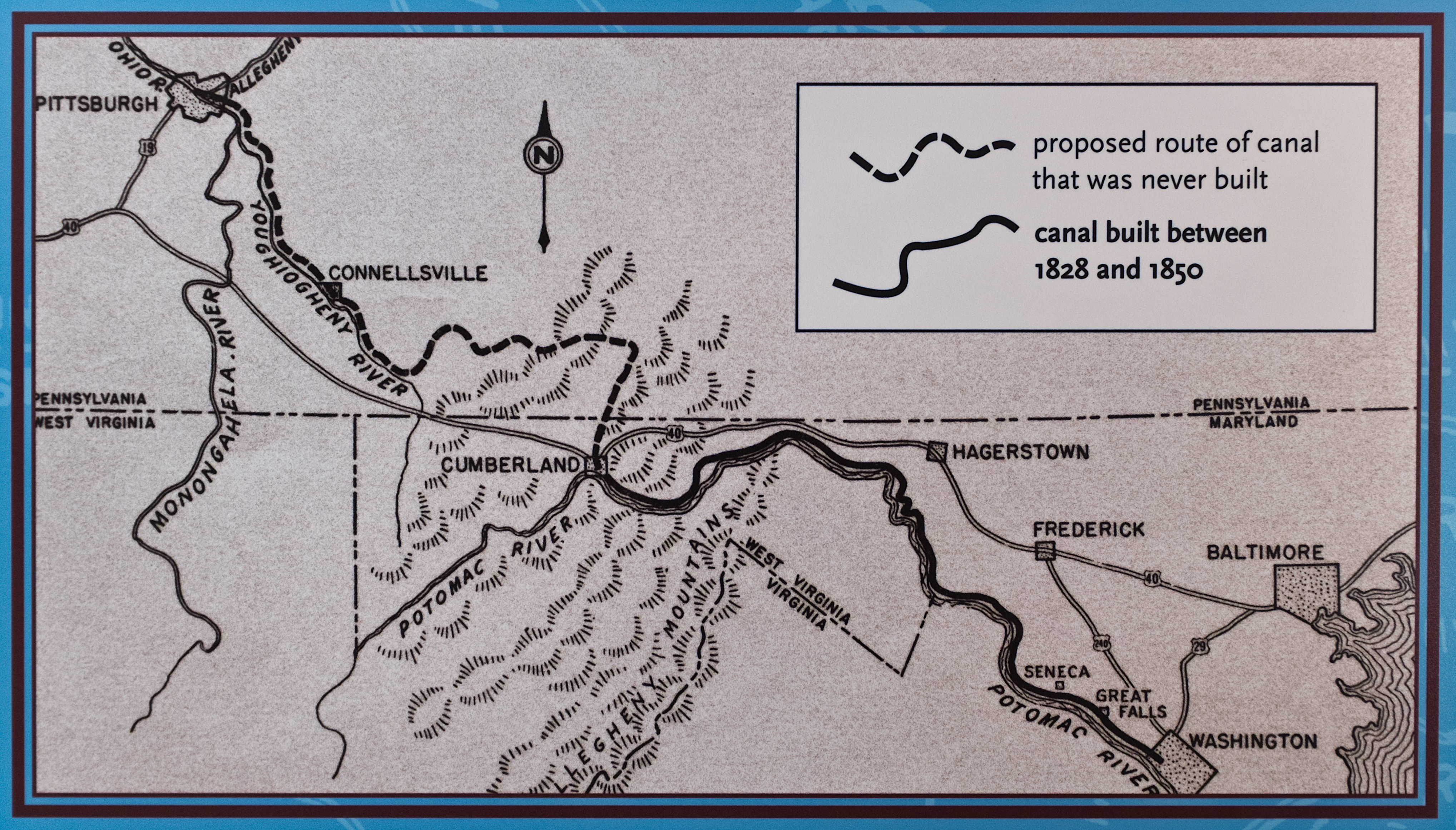
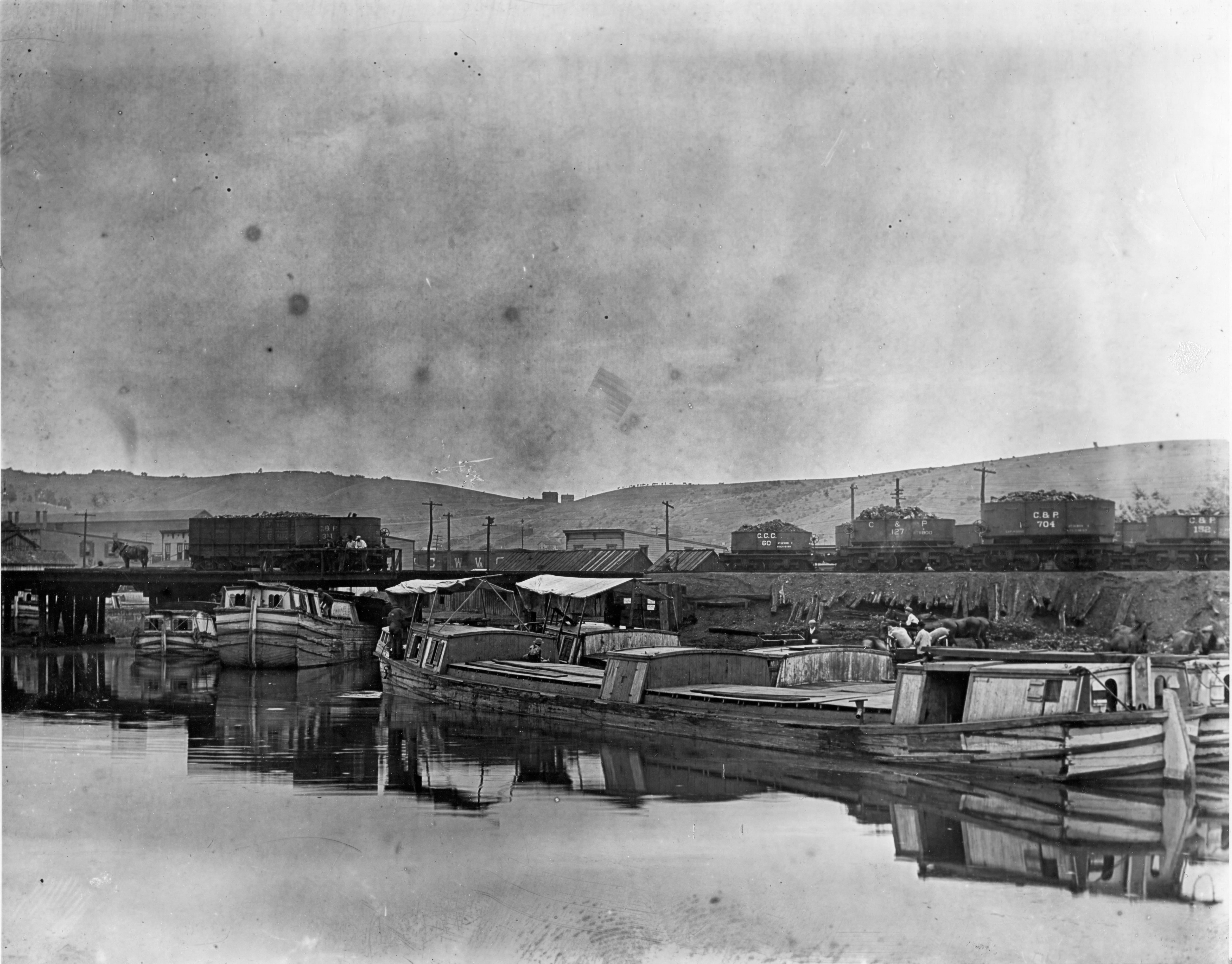
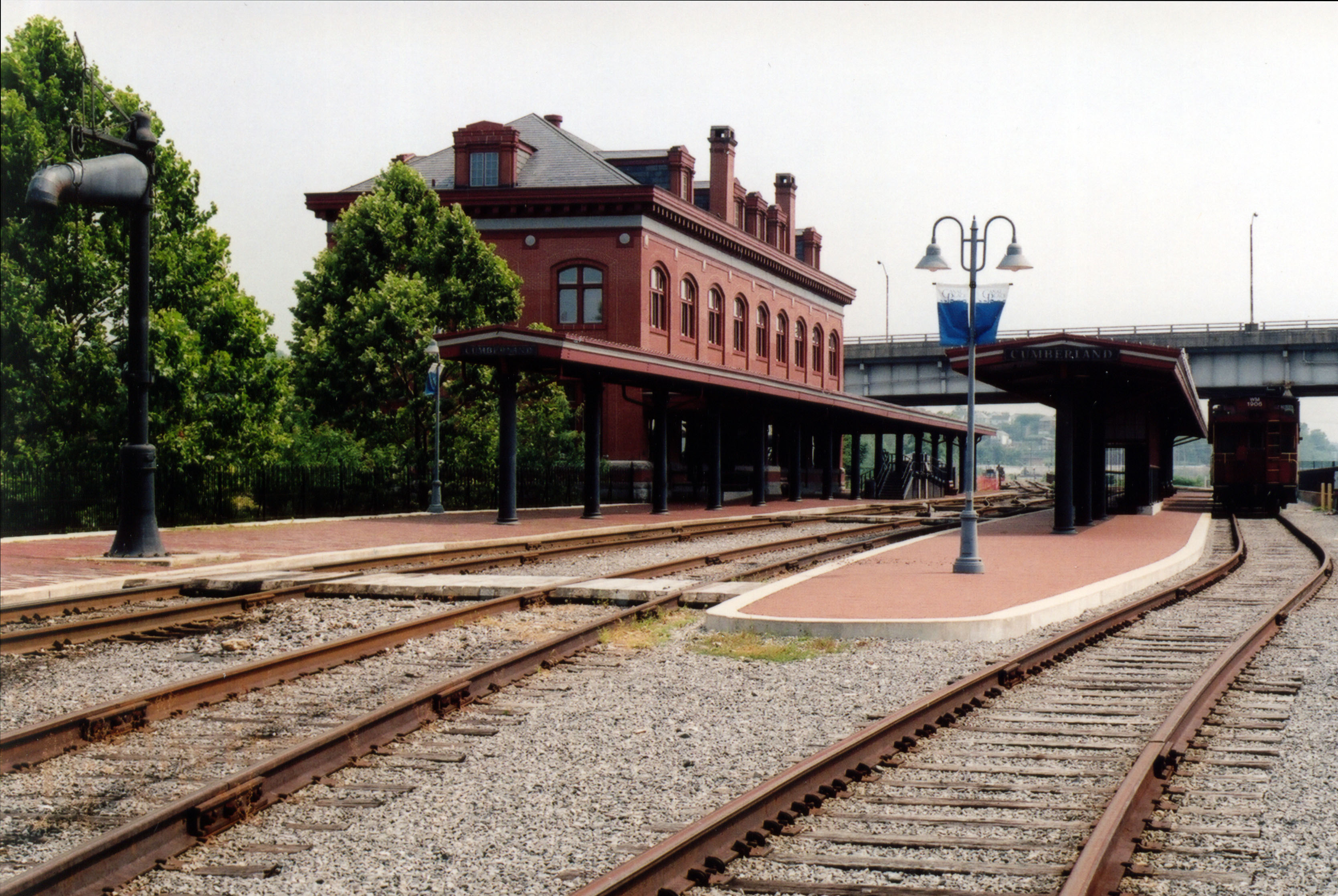
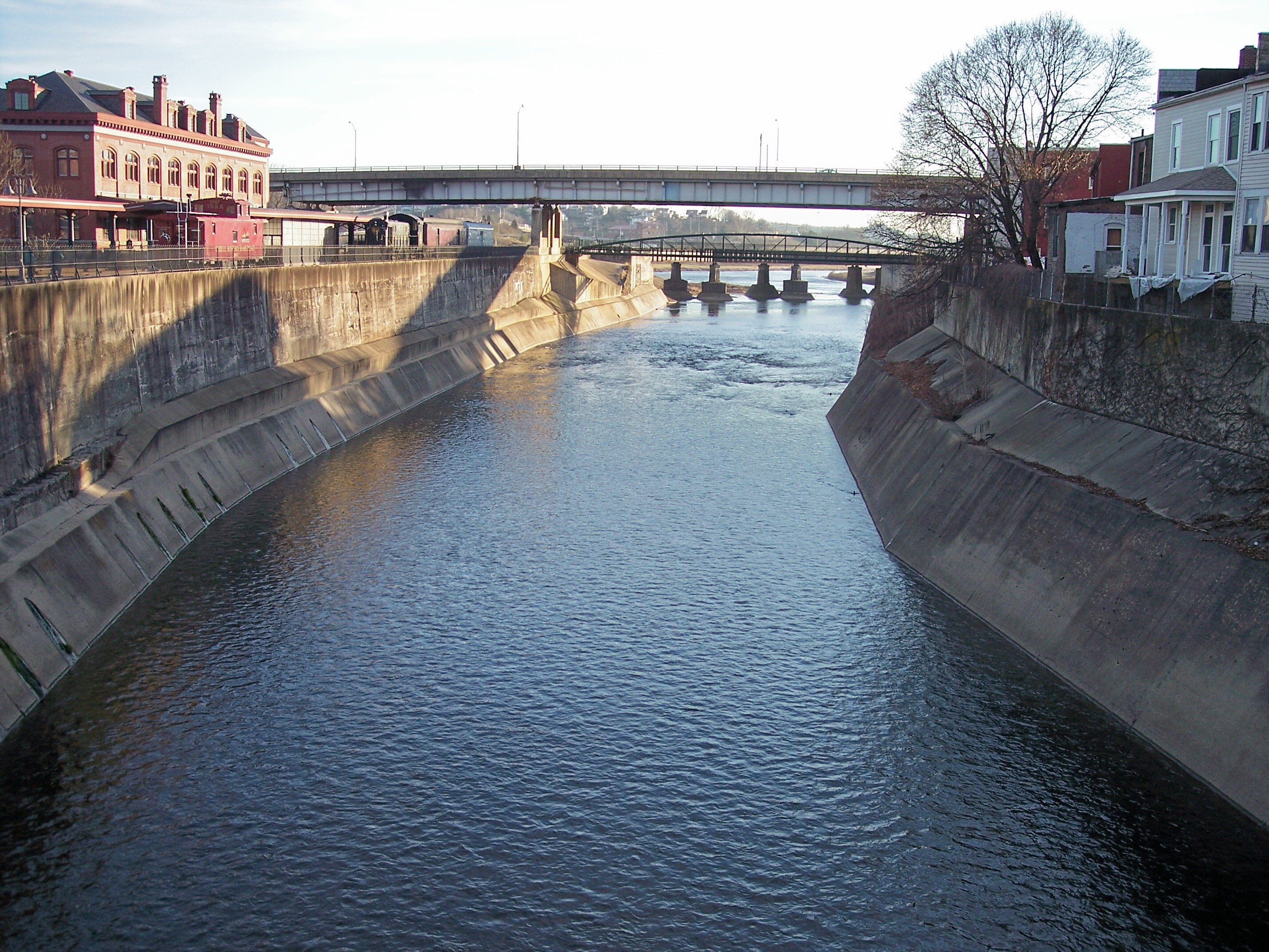
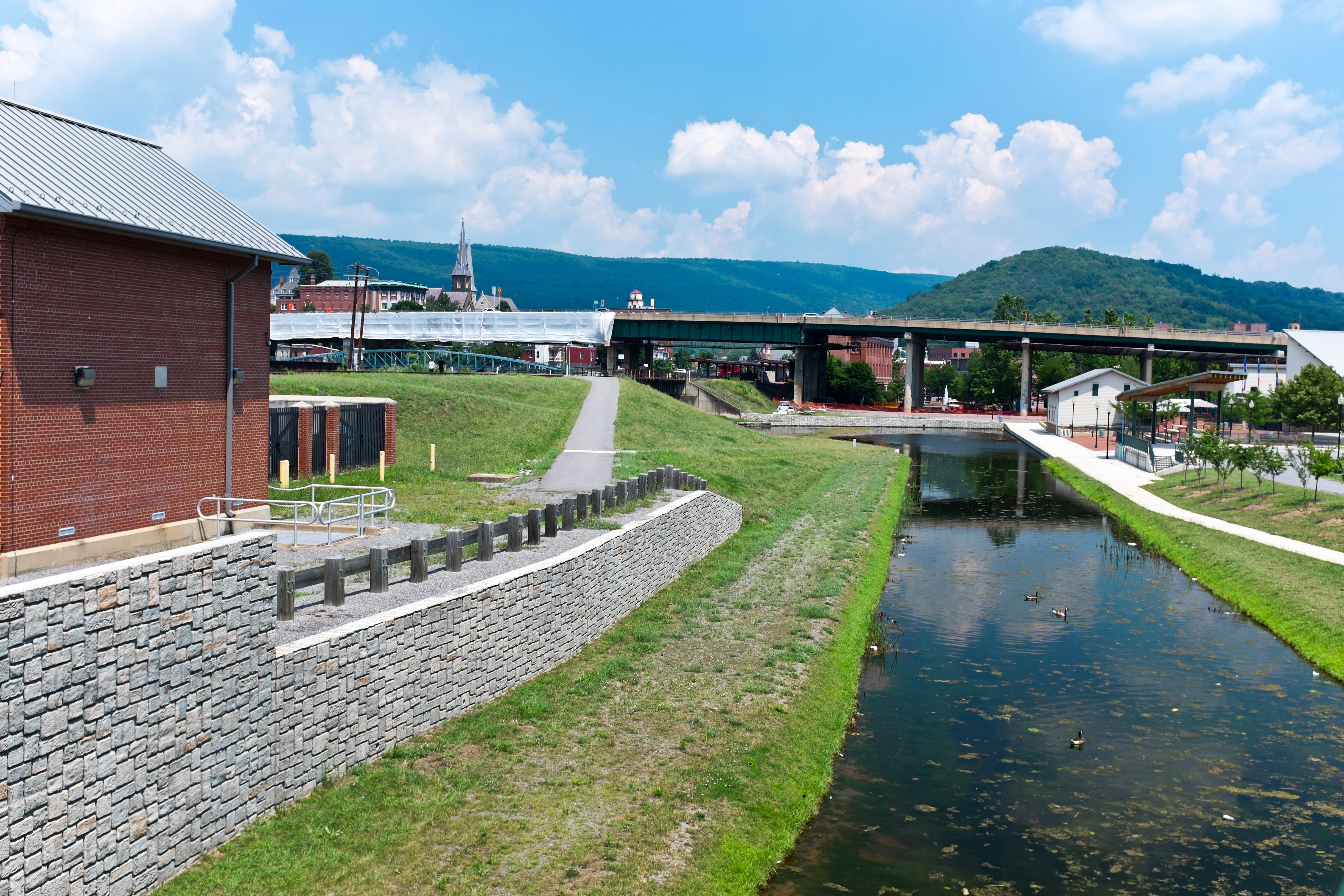
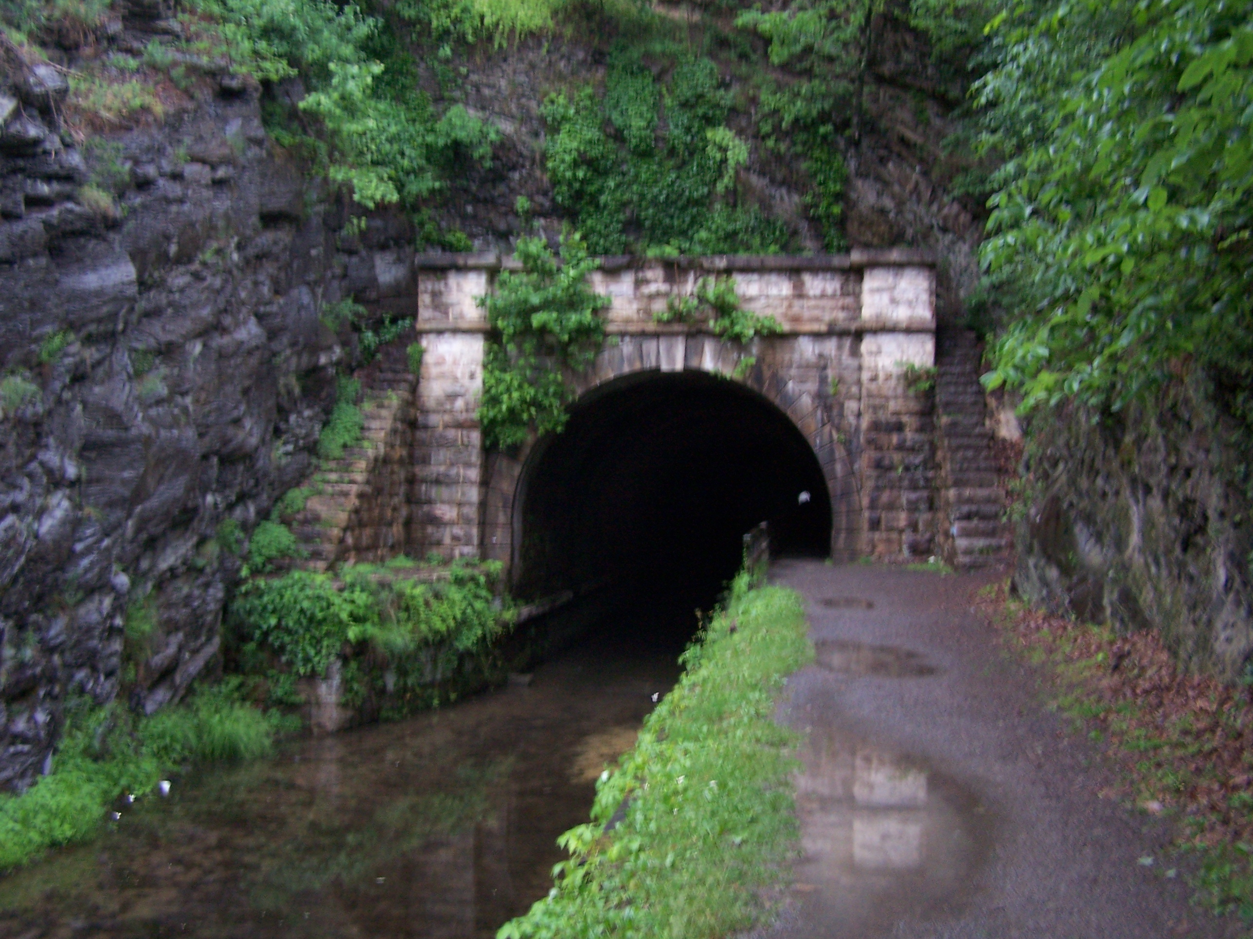
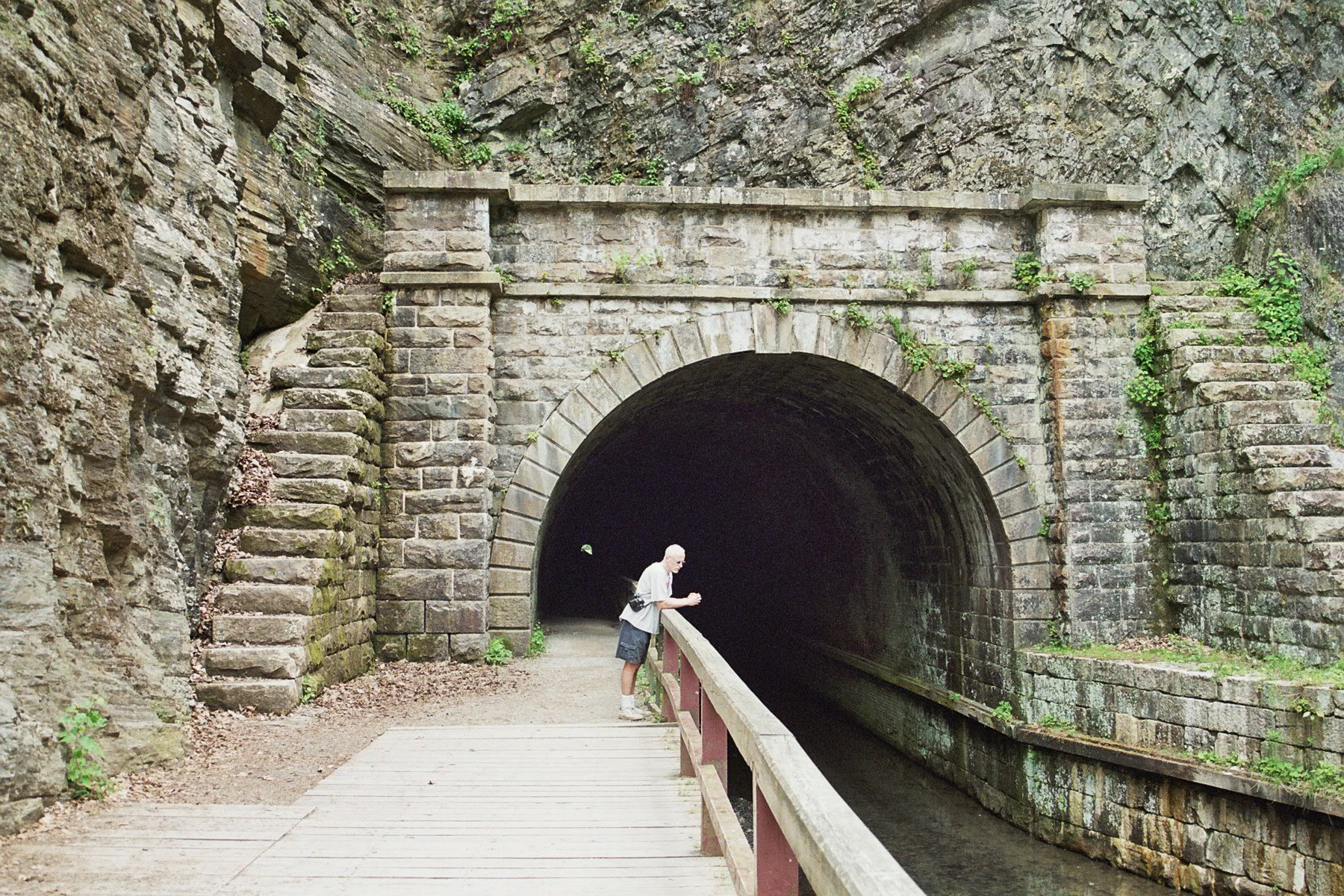
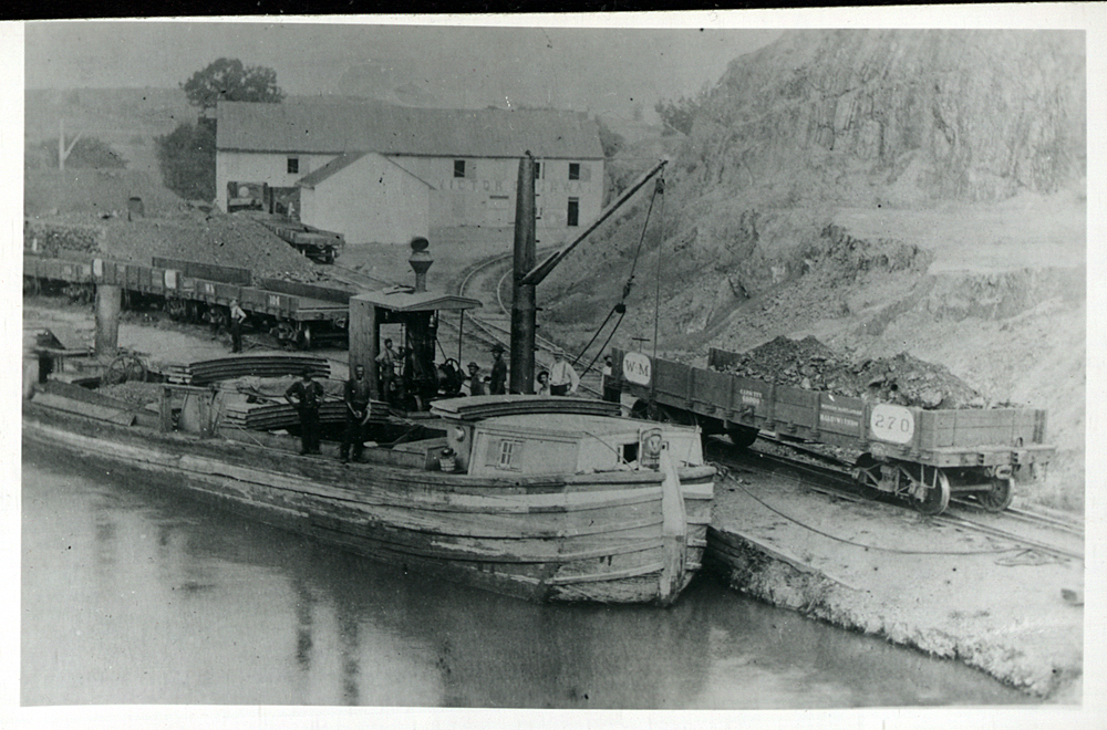
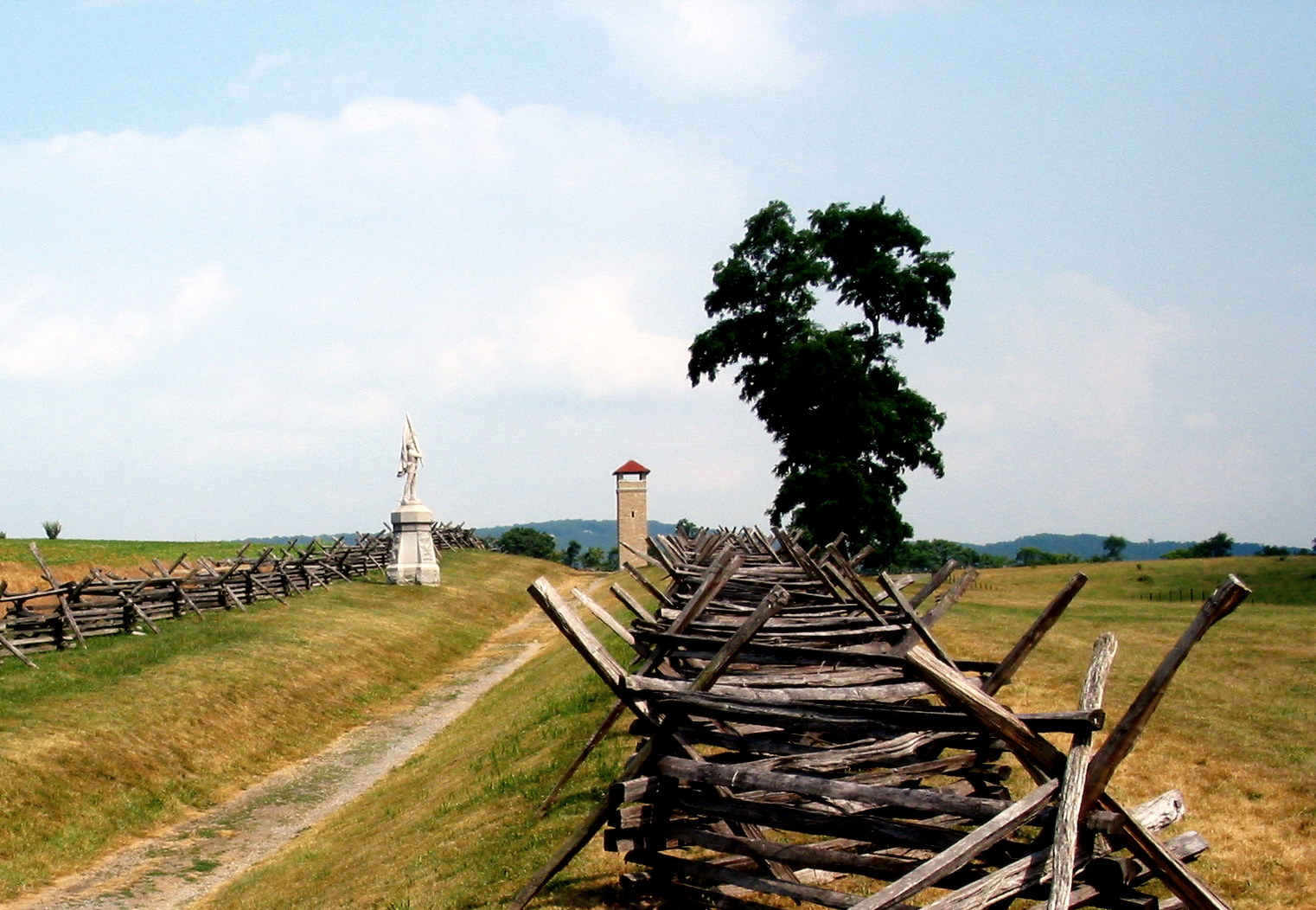
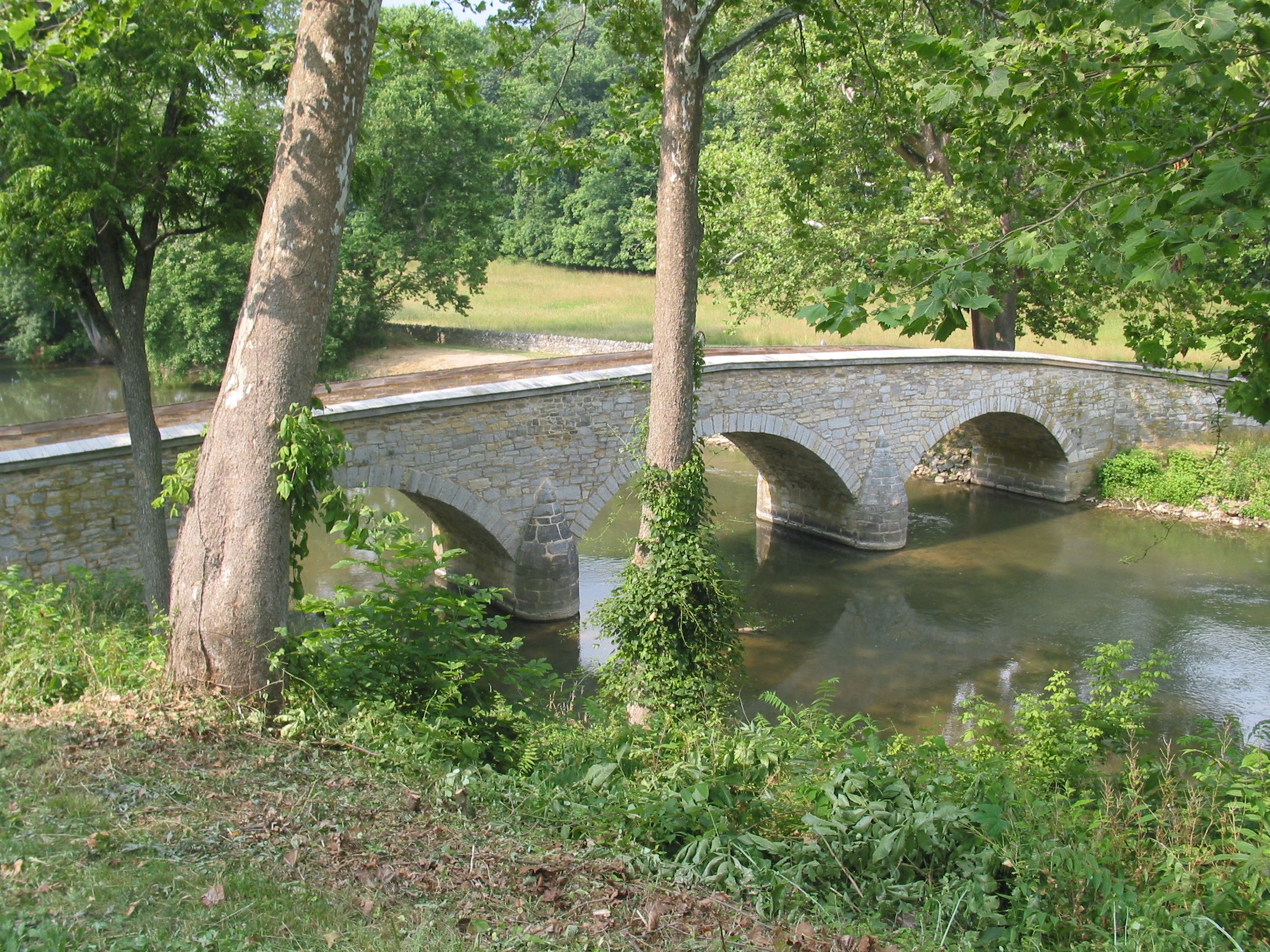
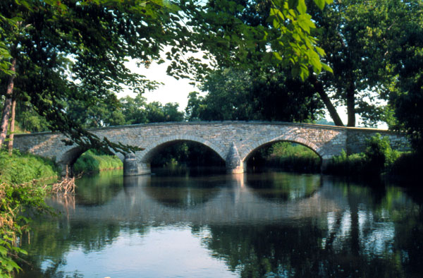
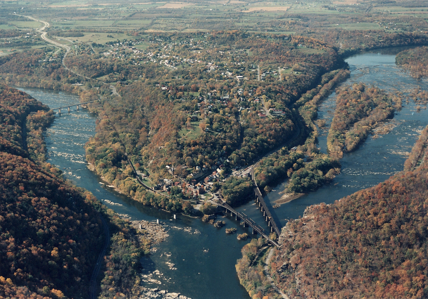
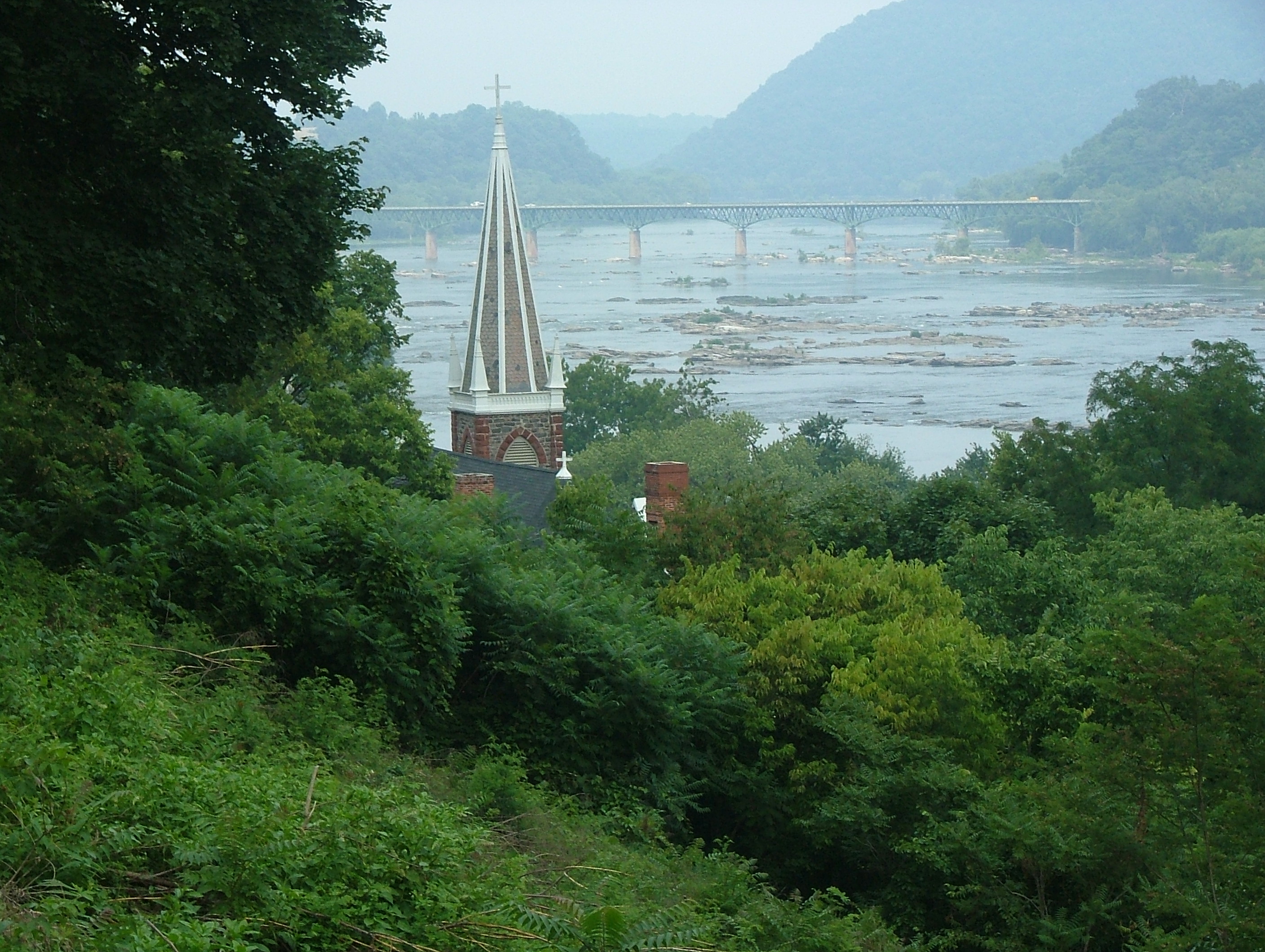