|
Reflections 2016
Series 15
September 27
East Coast VI: Rosslyn & Georgetown–Palmetto; Boards & Ships
| | Day 8 (later): Rosslyn & Georgetown Before we went off on the discussion of background topics, we left off driving down the river from the Great Falls of the Potomac toward DC.
http://www.bikewashington.org/canal/maps/map_a.png
| | | | As we approached Georgetown on the DC side (click), across the Key Bridge from Rosslyn in VA, the river began to widen, since our destination was at the beginning of the wide estuary of the Potomac. The inset map shows some preliminary detail of Georgetown, including the B&O towpath and Canal going down to Milepost 0, our destination later this afternoon. But for now, we do what the canal boats used to do. Just as they had the option (see inset map) not to continue on in to Georgetown, but make a right turn across the Aqueduct Bridge to Rosslyn and beyond, we have the option, after avoiding a freeway exit, of continuing a block north of the Canal onto M Street NW, the main E-W street of Georgetown, or turning immediately right onto the Key Bridge, which is what we do, and, having just left MD and entered DC, we leave DC and enter VA. I believe this is the third time in a couple of days we've crossed multiple borders within moments. | | | | It's only a triviality that, by staying a night in Rosslyn, we spent our first night in Arlington County, to complement having stayed in Alexandria once and Washington many times. The main reasons are its obvious accessibility to Georgetown, which is our whole purpose here, the fact that we get a free night on Starpoints at the Le Méridian hotel, the fact that Enterprise has an office there to return the car, and the fact that the hotel is two short blocks from Rosslyn Metro station, for a quick getaway to Union Station in the morning. For this trip, Rosslyn is a win-win-win-win. And it IS in Arlington, too.
http://www.virginiaplaces.org/transportation/graphics/alexcanal1900.gif
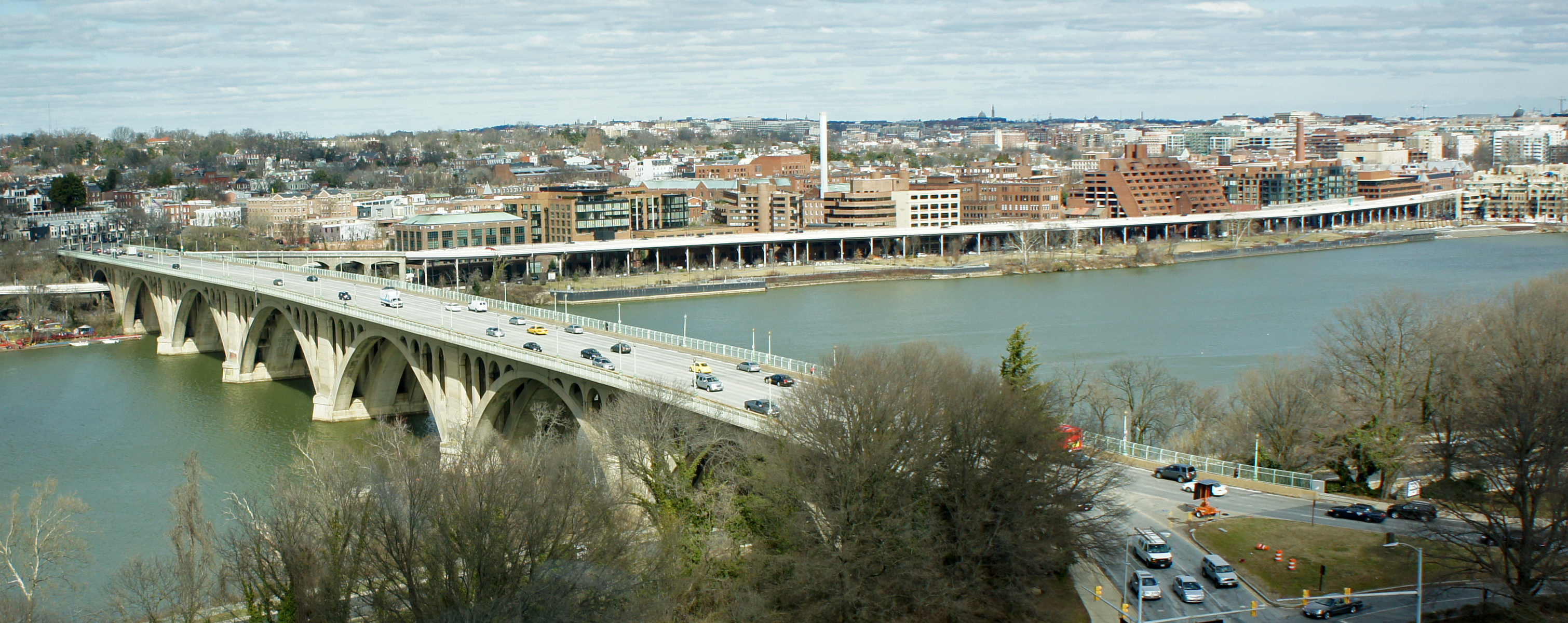
| | | | Rosslyn exists because the river is still relatively narrow here. In colonial times, there was a ferry between Rosslyn and Georgetown, a predecessor of first the Aqueduct Bridge and now the Key Bridge. A community gradually developed here at the ferry (see above map) that was named after a farm owned by William and Carolyn Ross—both were called Ross Lynn, then Rosslynn as one word. But since then, both the spelling and pronunciation have changed. An N was dropped to make it Rosslyn, and the pronunciation is now ROZ.lin. | | | | In this period map you can see an early name of the large nearby DC island, now called Theodore Roosevelt Island, a wildlife area named after the conservationist president and the only Washington memorial to him. The island was landscaped by Frederick Law Olmstead Jr, who we last encountered upriver at Great Falls. You can date this map to mid-19C by the name of the bridge—we saw an early photo of the bridge in the last posting where I commented how bucolic Rosslyn appeared there (it isn't anymore). It's hard to judge, but just about all the time we'll spend in Rosslyn today will be within the little diamond-shaped area surrounding the original "Rosslynn". | | | | Rosslyn today is just the opposite of bucolic, which is why it is NOT my favorite place. When you look across the river at Rosslyn (Photo by Payton Chung) from Georgetown today, you see a mini-Manhattan (click). If I want Manhattan, I go to Manhattan, not to the Washington area. For reference, note the pair of large buildings right in the center. The one behind the bigger one, and in its shadow, includes the Le Méridien Hotel. You can see how walkable it is to Key Bridge. This is the view of Rosslyn from the Kennedy Center (Photo by Farragutful). It's ironic that, from this angle, we see the very bucolic Theodore Roosevelt Island in the foreground. | | | | I've been to Rosslyn before, but it didn't strike me until this trip why its buildings stand out. I'm used to Washington, which is a low-rise city, other than a few monuments. So I checked, and sure enough, DC has had building height restrictions since 1899. But as we know, Arlington County is no longer DC, so Rosslyn has been building high-rises so that it has several of the tallest buildings in the Washington metropolitan area, making it stand out—in more ways than one. The area today is nice enough, but I find it soulless.
http://images.travelpod.com/cache/accom_maps/Marriott_Key_Bridge-Arlington.gif
| | | | I'd checked online maps in advance and knew just where to make my turns to return the car we'd picked up in Wilmington DE. Actually, it was quite easy. I'd like to demonstrate on the above map (click) how compact our activities in Rosslyn were in both space and time. From M Street (note the Francis Scott Key Memorial), we went over the bridge, and to reach Enterprise, drove Ft Myer Dr to a right on Wilson Blvd to its SE corner with Pierce St. Then it got difficult. Enterprise always has a parking lot but here there were high rises. I had to double park outside their office to be told to then enter the parking garage next door, which wasn't allowed to have the Enterprise name on it, and drive down four levels. It was just too confusing here. I was then given a ride to the Le Méridien at 19th St at Lynn, the NE corner. It was a very nice hotel, but if I had been paying cash I'd really have wanted a nice cozy B&B. It's the type of over-urbanized building where the lobby is on the 4th floor. I settled in, but then wanted to get my Metro ticket in advance to save time in the morning and also to know just where the station is. I walked to Rosslyn Metro Station, south of 19th, between Moore and Ft Myer. From there it was off to crossing the bridge, noting the Welcome to DC sign immediately after leaving the VA shore. | | | | And then as always happens, I learned something only post-trip. Look on the map and see how 19th Street, after passing the area of the station, becomes Nash St, and note a point on the west side halfway down to Wilson. I now know that this is the location of the most famous parking garage in the world. As soon as you hear its nickname, you'll know exactly what I mean. Any ideas? | | | | While the address of the office building is 1401 Wilson, it's this garage entrance on Nash, the side street, that's famous. It's known casually as the "Deep Throat Parking Garage", and is where, in 1972-3, Washington Post reporter Bob Woodward met with his long-secret source, nicknamed Deep Throat, later identified as Mark Felt, the FBI's associate director. Felt would give Woodward information for his investigation that later led to Nixon's resignation. They met at dimly-lit space 32 on level D, which is the bottom level, but because of the slope of the land on Nash down from Wilson, it's just below street level. Near that parking space there's also a convenient exit into the building that allowed quick ingress and egress for both men. They met in the wee hours after midnight when the garage was empty and dark.
http://cdn.patch.com/users/601727/2011/08/T600x450/7e7f6d672be71c77d8bfeacc255cbe2c.jpg
| | | | Eventually, Arlington County put up this historical marker on Nash, looking up to Wilson, to commemorate the event. Although I didn't get to see this, Google Street View showed me the sign's location at the entrance to the parking garage. It also struck me that high-rise Rosslyn is apparently a parking-garage center, since I returned the car to the other garage also four levels below the street. | | | | One last thing before we leave Rosslyn. This aerial view (click) shows everything we've mentioned (Photo by Mariordo). The smaller gray building on the right is Le Méridien, near Lynn Street leading to the bridge; the Metro entrance is below the brown highrise in the center; the Deep Throat Parking Garage is to the left, north on Nash of the trees in that tiny park; the old remnant of the Aqueduct Bridge pier is just offshore, peeking out to the left of Key Bridge; the Georgetown abutment of the bridge is to the left of the red cross; Key Park is to the right of the bridge at M Street. Also note Georgetown Waterfront Park, the riverfront park with an esplanade south of the elevated expressway—we'll be at both shortly. | | | | As we walk over the Key Bridge to Georgetown (Photo by Mariordo), we are reminded how the new becomes old. It's the newest crossing here, completed in 1923, but is nevertheless Washington's oldest surviving bridge across the Potomac, and is on the National Register of Historic Places. And other than driving over multiple borders, this is a walk of importance, since after walking from WV to MD in Harpers Ferry, I walked from VA to DC here. Once again, note Key Park at the end of the bridge, and the riverfront park esplanade south of the elevated expressway.
https://upload.wikimedia.org/wikipedia/commons/5/57/1850_Mitchell_Map_of_Washington_D.C._%5E_Georgetown_-_Geographicus_-_WashingtonDC-m-1850.jpg
| | | | Canal Stop # 9: Georgetown We are now on our way to visit the eastern end of the B&O Canal in Georgetown, our last Canal Stop, but we should become more familiar with Georgetown as a physical appendage to Washington, which Alexandria never had to be. We used the above 1850 Mitchell Map to explore the Washington City Canal. Now let's look closer at Georgetown and its streets. | | | | It was a small town with a small-town look and typical street names. As we saw in the last posting, Washington was laid out as a monumental city with N-S numbered streets, E-W lettered streets, and spectacular diagonals, which were all given the names of states, the most famous one being Pennsylvania Avenue. On this map, Georgetown is still a separate municipality, clearly separated by Rock Creek from Washington. I've walked many times when at a language conference near Dupont Circle over the P Street Bridge (not yet built on this map) or the Q Street Bridge (not even extended yet on this map) into Georgetown, and despite the fact that the street name remains the same, the difference between Washington and Georgetown is palpable. Both are nice, but they ARE different. | | | | Now look at the Georgetown map beyond Rock Creek on the left and inspect the names, some of which even had their own numbering system—we see the former 1st to 8th Streets. But most street names were changed when the two municipalities merged to conform the Washington pattern. However there were more human-scale streets in Georgetown, and so some kept their original names. Trace these changes, E-W streets first, many now lettered. | | | | All extended street names bear the quadrant label NW at the end, but I'll leave them off here. The former Bridge Street—you see the bridge over Rock Creek—is now M Street, the main E-W street in Georgetown. On the other side of the canal, the former Water Street—we saw that go under the bridge abutment—is now K Street. Worse, the elevated expressway is above this whole stretch of K Street. Further north, Prospect/Olive (Olive, unnamed, is on the right) retains its name, but 1st/Gay Street became N Street; Dumbarton remains, but Beall is O Street, West Street is P, and Stoddart is Q. Pennsylvania Avenue has been extended two blocks to merge with M at 29th Street (Montgomery). | | | | N-S are the numbered streets. As you can see, the numbering in Washington reached 27th Street NW, so Monroe/Mill got the same number. Montgomery, Greene, Washington (!!), and Congress Streets became 28th-29th-30th-31st Streets NW. Jefferson Street down by the canal falls in between, so it remains, now bears his full name, Thomas Jefferson Street. High Street was a diagonal, so it became Wisconsin Avenue, the main N-S street in Georgetown. However, there is NO 32nd Street, since Wisconsin counts as that. Potomac Street still exists, but Market, Frederick, and Lafayette became 33rd-34th-35th Streets. Further west, the numbers run up into the forties.
http://www.gallerysortathing.com/maps/map2.jpg
| | | | For our walk, I've found this excellent hand-drawn map of just the area we need (click). First confirm the street numbers and letters we mentioned, also Wisconsin Avenue, and a few other streets, mostly short, that retain original names. Note how the Canal runs just south of M Street, and note the Aqueduct Bridge abutment just west of Key Bridge. Hold on to that map for a while, but for the present moment, compare this helpful photo of the area:
http://www.memorieshop.com/Fort-McHenry/Memorial-Park.jpg
| | | | Coming to the north end of the bridge, we pass an off-ramp, then the expressway itself that has just left M Street at the top. We are then over the canal, fully rewatered here in Georgetown. We turn right off the north end of the bridge and the first thing we come to is Key Memorial Park, which we walk through on the way to the Canal itself. It's larger than shown on the map—the true size is on the aerial photo. It runs from the Canal to M, and covers much of the block west of 34th. It's a nice interlude to get to the Canal, but only now do I know why it's there, and why the Memorial Park is much younger than the 1923 date of the Bridge. It's an interesting story about historic preservation. There are two versions, the highly indignant version and a much more common sense version. | | | | I had heard that they gave the bridge Key's name because he'd had a house "nearby in Georgetown". Fair enough, but where? And that's when I found the first version of the story. Key had lived at 3518 M Street, on its south side. That would put it just to the left of the bridge. I came across the indignant version of the story first, that the Key house, despite efforts to save it, was razed in 1947-8 to permit construction of the expressway and its approach road. A variation said that it was disassembled, with plans to rebuild it elsewhere, but then the NPS "lost the bricks". This sort of thing would infuriate any preservationist, but then I researched it further, and there's no reason to be upset. Here's the complete story. | | | | The house was originally built by a local citizen in 1795, well before any bridges or canals were in the area. At that point, terraced gardens sloped down gracefully behind the house to the Potomac. Francis Scott Key leased the house and lived there from 1805-1833. That means that he was residing here in 1814 when, at age 35, he traveled to Baltimore for legal reasons, which ended with his writing the US national anthem, but that entire story will be discussed when we get to Baltimore at the end of this trip. | | | | It was, ironically for our present trip to see the B&O Canal, that it was the very building of the Canal that caused Key to move. The Canal was cut right through that delightful, terraced back yard of his, cutting off his access to the river, similar to what happened to the residents of Foggy Bottom, which later resulted in the canal extension being removed. For Key, the resulting boat traffic reduced the desirability of the house, and so he moved. Another reason for the move was that he had been appointed United States Attorney for the District of Columbia as of 1833 (to 1841), and so he moved near Judiciary Square in Washington City, where he also maintained a private legal practice. | | | | But this is what happened to the Georgetown house. He died in 1843, and ten years later, his heirs sold the house to a family that used it as a hotel and restaurant. Later, new owners changed a window to a door to make it into a blacksmith and machine shop. Other owners in 1895 changed the former law office extension on the side into an ice cream shop.
http://1.bp.blogspot.com/-YPdg2vqj8vY/U4_C5HZqL6I/AAAAAAABie0/PYGpdjp_kmY/s1600/Francis+Scott+Key+House+-+prior+to+1921.jpg
| | | | Above is a colorized 1895 photo of the house, looking down to the Potomac, showing the ice cream shop. The building then became, in succession, a boarding house, dry goods store, shoemaker, and drug store. In 1913, the owners chopped off the rear portion of the gable roof and added a flat roof in its place. The wooden front façade was replaced with bricks and a plate-glass storefront. The original exterior chimney was demolished as was the small west extension. In doing this the contractors made off with the historic window sashes, doors, lathing, beams, and other woodwork. What a mess! | | | | In 1933, a restoration was proposed, but architectural consultants said the house had been far to altered to have anything but "sentimental value". A local citizens' association opposed any attempt at a restoration, and Key's great-grandson publicly announced his opposition as well. So when the house was dismantled for the freeway, there was no interest, and certainly no funding, to rebuild it, even if the bricks hadn't gone astray. It had been lost long before that, and people were ready to pull the plug. | | | | With the house gone on M Street west of the Bridge, the Key Memorial Park with his bust was formed east of it in compensation. The story goes to show that, while historic preservation is important, in a case like this, common sense has to prevail. | | | | | | FLASHBACK ONE: I have to insert here a very pleasant memory that involves Georgetown. The reason for my familiarity with Washington is because for almost three decades, Beverly and I attended the annual meeting of the Northeast Conference on the Teaching of Foreign Languages. During the time we attended it, it was held once in Boston, once in Baltimore—my first extended visit there before this trip—and otherwise alternated each year between New York and Washington. That's a lot of visits to Washington.
One particular year—I don't remember which--was extra special because the Conference had arranged embassy receptions for language teachers, and we went to two. Since Beverly was teaching French then, we went to the nearby French Embassy one evening for a reception where the champagne flowed. The only slight negative was that, since there are a lot of teachers of French, it was rather busy and crowded. But all these years later, I see much has changed. Even the large convention hotel a few blocks north of Dupont Circle seems to be gone, and the French Embassy has apparently moved. But with internet tools, everything is findable, and with additional information to boot. It amazes me how little we knew at the time.
http://www.gwuisc.com/uploads/2/1/0/4/21049162/44182_orig.jpg?385
https://c1.staticflickr.com/1/325/19818219986_32976cc3c4_b.jpg
Find the Dupont Circle neighborhood on the map. 16th Street NW runs north on its right side to a slender park. At the top of the park, on the Adams-Morgan side, is 2460 16th Street NW, the Beaux-Arts building now known as the Old French Embassy (second picture), which has now been recycled for something called the Council for Professional Recognition. I now know it was built in 1906-7 as a private mansion. Nice memories of being here for the reception.
http://www.aaccessmaps.com/images/maps/us/dc/georgetown/georgetown.gif
But we were both teaching German, and so the next night we went to the reception at the German Embassy in Georgetown, which, we were told, is way out on Reservoir Road, beyond Georgetown University. The German reception was more intimate, as the group of German teachers was smaller, so we piled into several taxis for the ride across town, way to the west. On this map, judge the difference between the center of Georgetown at Wisconsin and M out to the university. I've now discovered that the French Embassy has since moved here as well. It's at 4101 Reservoir Road NW, an address that places it opposite the university between 39th and that park. I understand it's France's largest foreign embassy.
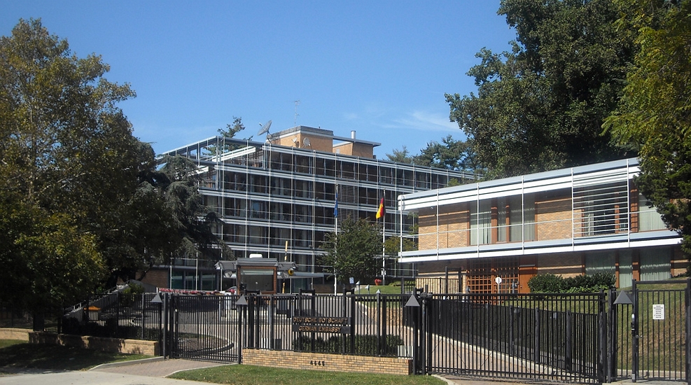
But the German Embassy (Photo by Josh Carolina) was, and still is, further out still, at 4645 Reservoir Road NW, a house number that puts it (see map) facing 47th Place. When we arrived (Photo by German Embassy Germany.info) for our memorable evening, we just saw it as a contemporary building (1964) that just happened to house the German Embassy (Image by Gnesener1900). Again, with the internet I now know more. It's in the functionalist style, meaning design should follow function, and enjoys an international reputation. It apparently still today is a destination for architectural students who admire its form and innovations. But I remember best that reception. Now let's leave these embassy reveries and get back on the Key Bridge.
|
| | | | While walking across the bridge, we had noticed many rowers in kayaks enjoying the river. Before we reached the Key Park, we had this view from the bridge down over the Canal to the east (Photo by Nashpaul). Click to inspect the small bridge in the foreground where the towpath crosses over from the south to north side, and compare that with our map. I have to assume that was where the mules crossed over, and when we get down there, we used it as well to visit both sides of the towpath. In the distance are the 33rd Street Bridge and Potomac Street Bridge; Potomac Street, mentioned earlier, is that extra street before Wisconsin Avenue (=32nd Street), whose bridge is also in the distance.
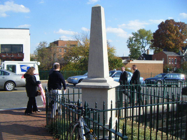
| | | | As we walk east along the towpath, now on the north side of the Canal, we soon come to the Wisconsin Avenue Bridge (Photo by DC Public Library Commons), and notice a rise in height of the buildings on the left. Could it be that Wisconsin was once called Hill Street indicates that this area was a little higher? Anyway, the building on the left of the towpath is actually a several-story garage, and there's an entrance just before the bridge. We go up several flights of stairs, and are out on Wisconsin Avenue. Right across the street is Filomena, where we have a reservation in a couple of hours. Turning right to the canal, we see, right above the canal in the lower right corner the C&O Monument we showed in a posting last year. It's also noted on our map.
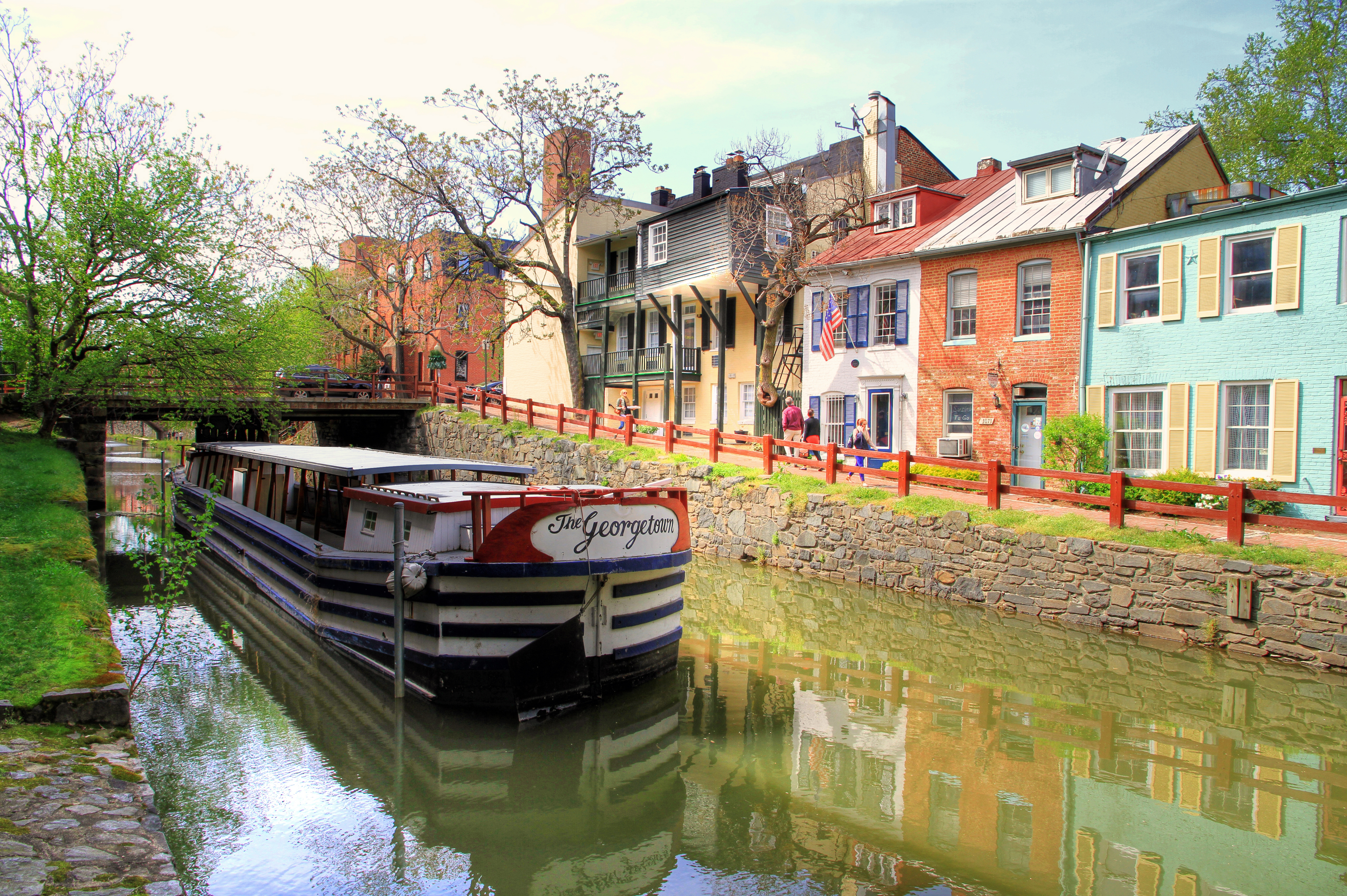
| | | | But we get back down to the Canal, because we'll be seeing a lock about every block from now to the end (see map), and it's the prettiest part of this stretch. We pass 31st Street, and this is Lock 4 (Photo by Bonnachoven), looking east to the Thomas Jefferson Street bridge, and (click) beyond to Lock 3 and the 30th Street bridge. The neighborhood is now getting very bucolic, and village-like. Once we pass Jefferson, If we turn around and look back, we come to the prettiest photo I've found of the area (Photo by Ingfbruno). It just doesn't get any better than this.
| | | | This picture wasn't captioned adequately, so let me tell you how I identified where it was. Click to see the address 3073 on the red brick house. This means that 30th Street is behind us, that we're looking back west, and that the bridge is the Jefferson bridge with 31st Street beyond it. While the canal boat adds to the bucolic scene, the only one that operates we saw up at the Falls. I've now read that the "Georgetown" canal boat rides ceased operation in 2010 due to the aging and unsafe condition of the canal boat. Sic transit (same pun again, still intended). | | | | Take a look at a historic photo of Lock 3 back in the day. With the towpath on the left, this must still be looking east to 30th. You'll recall that today there's a bust of US Supreme Court Associate Justice William O Douglas, who saved the Canal, erected here at Lock 3 (picture in 2016/13). | | | | Between 30th and 29th we see Lock 2, as shown in this 0:47 YouTube video. It first looks back (west), then ahead (east) to 29th. Finally, we reach Lock 1 (Photo by Sebastian Wallroth), looking east, just before Rock Creek.
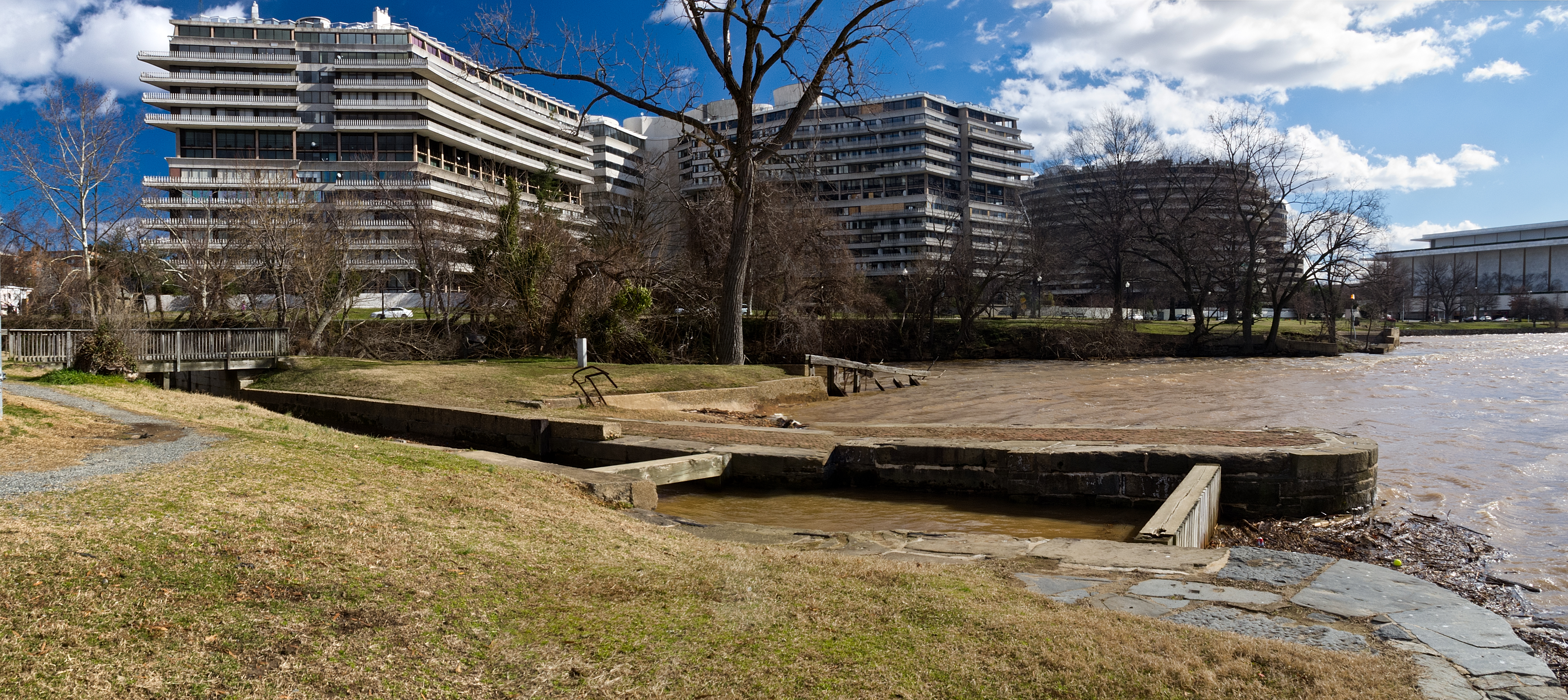
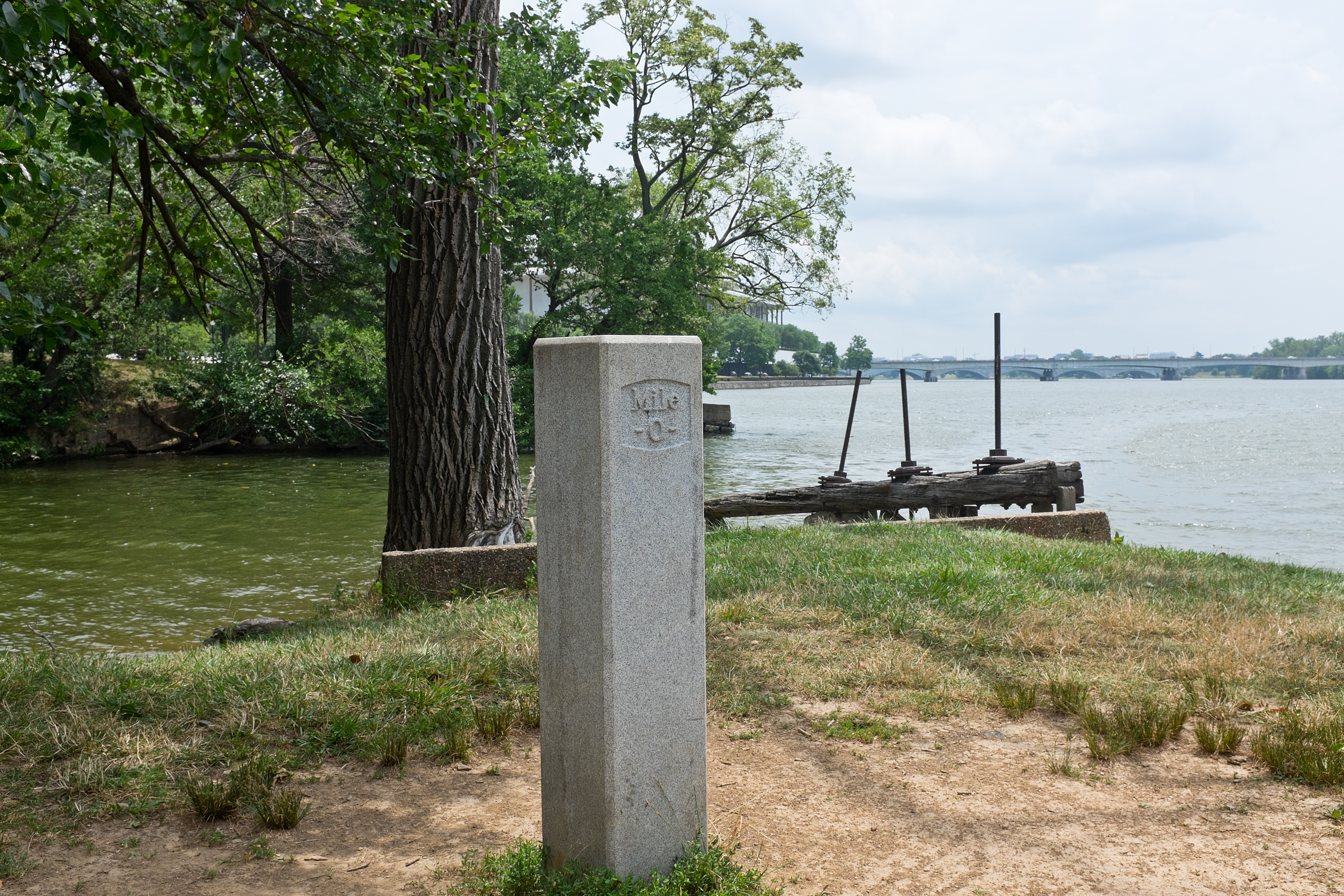
| | | | We are not done here, and it gets to be less fun for just a few minutes, and after that, much nicer again. As our map shows, the Canal turns right and enters Rock Creek at the tangletown of the Rock Creek Parkway, so we have to put up with the 20C-21C for a few minutes, dodging overpasses and on-and-off ramps. We'd found directions in advance telling us to suffer these indignities, but then to persevere, as it all ends at the Potomac at the Thompson Boat House, part of the long Georgetown Waterfront Park esplanade. We have to walk completely around the boathouse to see our next stop, where Rock Creek, and therefore the Canal, join with the Potomac. | | | | As the map shows, we're at the Tidewater Lock, Lock 0 (Photo by Bonnachoven). Click to see the Theodore Roosevelt Bridge in the background. A tidewater lock is referred to as a dam, and this detail is referred to as a gate pocket. At the time, I had difficulty understanding why this wasn't considered the first lock, but I think I understand now after learning about the Washington City Canal. You'll recall that that canal failed because it was directly connected via the tidal Tiber Creek to the Potomac, and low tides could drain water out of the canal. I believe the tidewater lock here prevented the same happening to the C&O, and was not numbered with the others because of its unique construction and purpose. | | | | This is the more comprehensive view, over to the east, of what was called by the canal company the Rock Creek Basin (Photo by Bonnachoven). completed in 1831. In the foreground is Lock 0, and just beyond, as on the map, Rock Creek empties into the Potomac. It was from this basin that the former extension into Washington had been built. Look across to the east bank of Rock Creek and you'll find the (in)famous Watergate Complex, with the Watergate Hotel, and a partial view of the Kennedy Center to the right. Since the 14C, "watergate" has referred to a channel for water and a floodgate. This entire canal area is the "watergate" from which the complex took its name, especially since early on, part of the land of the Complex on the other side had belonged to the C&O Company. Click to see on the left that footbridge over the lock and also the little white marker. Let's walk across that footbridge to inspect Milepost Zero (Photo by Bonnachoven). Click to see it better, as well as the mouth of Rock Creek, the Kennedy Center, and the TR Bridge. | | | | | | This is a picture and an excerpt from 2016/13, when we were in Cumberland:
http://4.bp.blogspot.com/-cBJXEok3r34/U8cZ4YAms-I/AAAAAAAAAy8/7B-HjYWXxNI/s1600/IMG_8794.JPG
This is the highest mile marker on the canal, at 184.5 mi (297 km), and our goal is Mile 0 in Georgetown.
And so we made it.
|
| | | | Afterward, it's worth sitting down on a bench outside the boathouse and watching all the kayaks being brought inside and stored on racks, directed by a man in charge. It seems to be some kind of a class or club for older teenagers. We then continue down the esplanade, past outdoor cafés and fountains, to the river end of Wisconsin Avenue, following it up over the canal bridge and just beyond, to Filomena Ristorante on the right. Beverly and I had been coming here for years, but this was the first time in quite a while that I've been here. It's a local icon. When I was coming down on the hotel elevator with another guy, a conversation evolved, and when the name Filomena came up, he didn't ask me what it was, his reaction was, oh, yeah, he hadn't been there in a while, and he should go again. But the storefront of Filomena belies to the newcomer that a large, prestigious restaurant lies beyond. Most of the façade, to the right, is taken up by a small, square closed room. And as you enter to the left, you find you're watching one or more of the Filomena "Pasta Mamas":
http://orangejuiceinbishopsgarden.com/blog/wp-content/uploads/2012/03/Filomena1.jpg
https://img.washingtonpost.com/wp-apps/imrs.php?src=https://img.washingtonpost.com/rf/image_908w/2010-2019/WashingtonPost/2015/04/23/Magazine/Images/IMG_1628.JPG&w=480
| | | | Although it's for show, they really make some of the homemade pasta served here. To the left is a small vestibule with a bench at the head of a flight of stairs. At this point you realize that this small entry at street level is deceptive, as it's followed by the huge dining room down one flight. | | | | But do not picture that it's a cellar. Remember, the building abuts the C&O Canal directly, and, just as the parking garage on the other side of Wisconsin has several sublevels, Filomena has at least one, probably more. In other words, you enter Filomena on the upper floor on the west side of a building positioned facing south over the towpath—as proof, there are windows on the south side of the dining room.
http://ep.yimg.com/ca/I/yhst-31290725707727_2134_90168
| | | | Former German Chancellor Helmut Kohl has been a regular since the restaurant opened in 1983. In 1994, he and Former President Clinton (both above admiring pastries), while both still in office, conducted a working lunch at Filomena, and both met again for dinner in 1997. The woman is the founder, JoAnna Chiacchieri (kya.KYE.ri), who named the restaurant after her mother, although now she lists herself on their website as though her name is JoAnna Filomena, probably thinking no one's the wiser. I suppose her real name IS hard to pronounce. Although many celebrities have dined there, this Kohl/Clinton framed picture is prominently displayed.
| | | | Celebrities that have dined here include Former President Bush Sr, VP Biden, Hillary Clinton, and airline captain Chesley Sullenberger. If you're interested in seeing more, check their website. Among others, I recognized pictures of Pavarotti, FF Coppola, D Hoffman, Newhart, Crystal, Sinatra, Angelou, Hawn, Goldwater, and the Reagans.
http://guia.melhoresdestinos.com.br/system/fotos_local/fotos/13774/show/filomena-ristorante.jpg
https://www.zagat.com/proxy/v1.4?m=image&a=resize&url=http%3A//storage.googleapis.com/zgt-photos/0x89b7b64bfd853a3d_0x603d1999c9518ff6/62e727d8988770734c8097601f3da50b.jpg&width=497&height=286&key=abbc09b7c840c10937a4db331422c98b
| | | | The décor is absolutely over the top, and that's part of the charm of the place. All waiters are in tuxedos. Arriving early for my online reservation, I chatted with the maitre d'. Seeing an Italian name, he bonded immediately, and personally showed me to my table, off along the wall on a banquette to the left of the first picture, and much like the second. | | | | My waiter was no kid earning extra cash, but a seasoned professional. Reading the wine list in search of just a glass of wine, I noted that they had Vernaccia (ver.NA.cha) on the list, but only by the bottle. You don't find it too often, and I like to order it when it's available. | | | | | | FLASHBACK TWO: Again, a trip to the past. Beverly and I first discovered Vernaccia in July 2002 (according to my travel diary) driving on a day trip south out of Florence to San Gimignano (Photo by Bjørn Christian Tørrissen) (ji.mi.NYA.no), the walled, medieval hill town that's a UNESCO World Heritage Site. It's particularly famous for its fourteen surviving towers (click) and its Romanesque and Gothic architecture. After visiting the town, we drove out into the Tuscan countryside (Photo by Deror avi) and Tuscan hills, to a country inn for dinner that we found in the Michelin Red Guide Italia. It was quiet and peaceful as we dined in the garden. I don't remember the meal, but do remember the wine list that listed one Vernaccia di San Gimignano (Photo by Pablo) after the other. We discovered it to be a crisp, white wine, and I now read that the earliest recorded mention of it dates from 1276 and that since the Renaissance, it's been considered one of Italy's finest white wines. I agree.
One of my favorite stories involves the time we went to an Italian restaurant on Long Island that, I found, happened to serve the wine. When I, wine list in hand, told the little Italian-American waiter I wanted a bottle of Vernaccia di San Gimignano, he looked at me, startled, clapped his hands together, and said "Oh, you say dotta so nice-a!" So I have lots of fine memories associated with Vernaccia.
|
| | | | So what to do? The waiter was quintessentially cool about it. Why didn't I order a full bottle, use as much with dinner as I like, and then he'd recork it so I could take it back with me? I know that's legal in some places, and have done it, and thus found out that DC was one of them. Done.
http://farm9.staticflickr.com/8100/8451508097_54c53394ee.jpg
| | | | As an appetizer, I chose Salsiccia alla Griglia della Casa, homemade grilled sausage (and peppers), and my main course was Gnocchi della Mamma alla Bolognese, homemade potato dumplings in meat sauce. Heaven. | | | | Of course it was too much, so I had half the gnocchi wrapped up, and I left with a Filomena bag holding a half-bottle of Vernaccia and half-portion of gnocchi, with plastic fork, for the next day. Reaching the street, I was still expecting to walk down M Street and over Key Bridge, but I thought better after a long day, full meal, and half-bottle of wine. I found an empty cab, and in no time I was back in Rosslyn with my prizes. | | | | Day 9: Palmetto The Palmetto left from Union Station at 10 AM, so rushing in the morning wasn't necessary, but I'm glad the Metro was nearby, and that I already had my ticket.
http://www.wmata.com/rail/docs/color_map_silverline.pdf
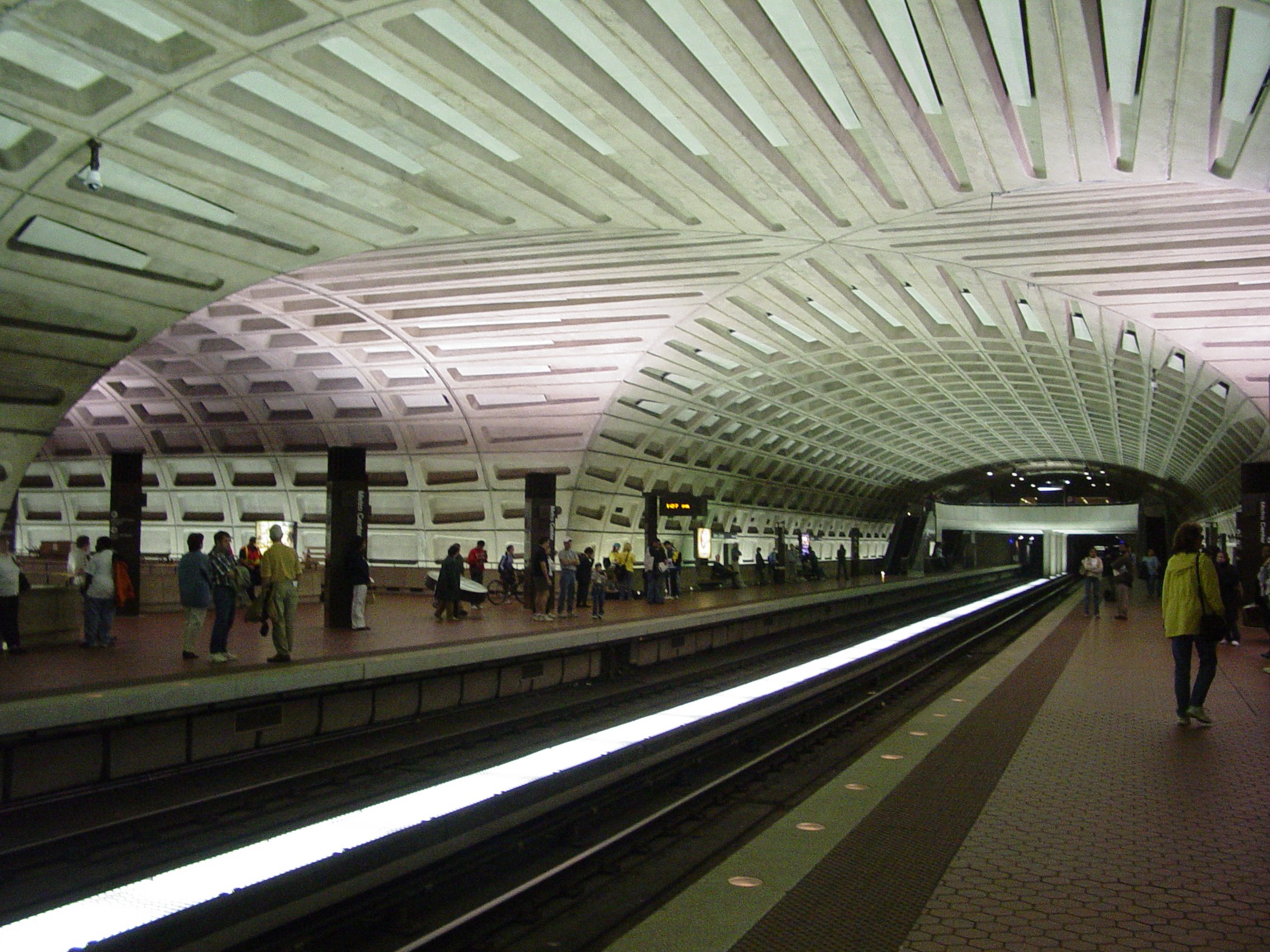
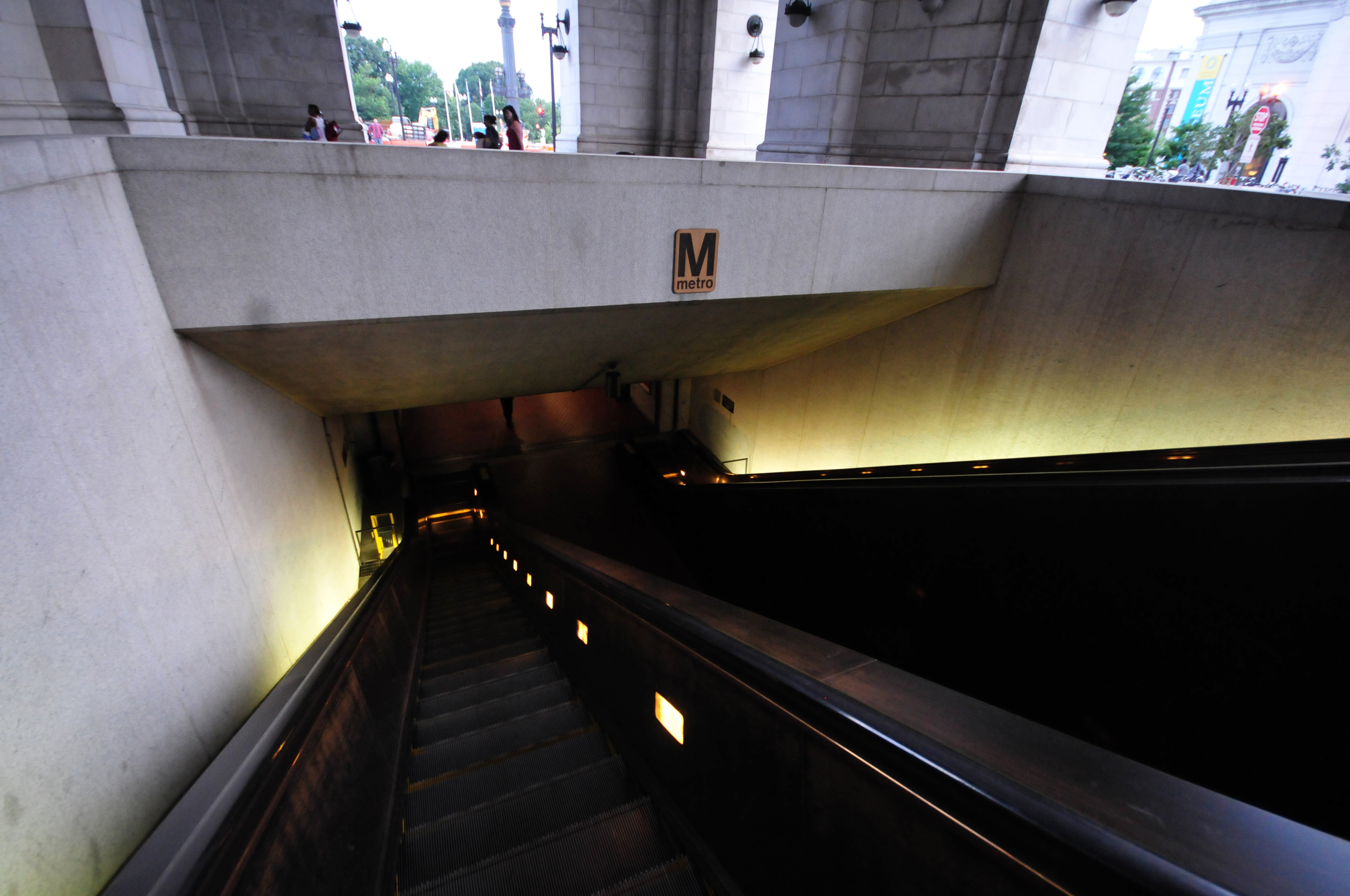
| | | | Having a station at hand is especially important here, since I find the Washington Metro tends to have stations rather spread out between each other, more like Moscow and St Petersburg rather than New York, London, or Paris, were stations are often closer. But at least there IS a system; it opened in 1976, and I remember maneuvering Washington's monumental grid plan before that without it. A particular quirk is that Georgetown's citizens objected to having a station there, since they felt it would bring "riff-raff" into Georgetown, so you'll see that the next station after Rosslyn inbound is way over in Foggy Bottom, a particularly long distance. You'll note that the system serves all three parts of the original DC, that is, DC, Arlington, and Alexandria, plus other MD and VA suburbs. | | | | I've never had occasion to go to the far end of the Red Line, but I understand that the Forest Glen station is the deepest in the system, lying 60 m (196 ft) below ground. It's so deep, there are no escalators—a bank of six high-speed elevators take 20 seconds between street and platform. The neighboring Wheaton station is the second deepest at 43 m (140 ft) and has the longest continuous escalators in the US and in the Western Hemisphere, at 70 m (230 ft)—that's an angular measurement, of course. The escalator trip takes 2min 45 sec. | | | | I mention this because Rosslyn Station, located on a river bluff above the Potomac, at 36 m (117 ft), is the third deepest in the system and the deepest station on the three lines serving it). Its escalators (Photo by Justin Henry), however, are the fifth longest in the system at 59 m (194 ft). The ride down takes about two minutes—and here's our train (Photo by Ben Schumin). As the map shows, to get into town from here we can take either the Blue, Silver, or Orange Line. As it turns out, we do catch the Blue Line as the picture shows (click). However, it's dated. In 2004, the last stop was extended from Addison Road to Largo Town Center. Still, I continue to be amazed at the selection of online photos.
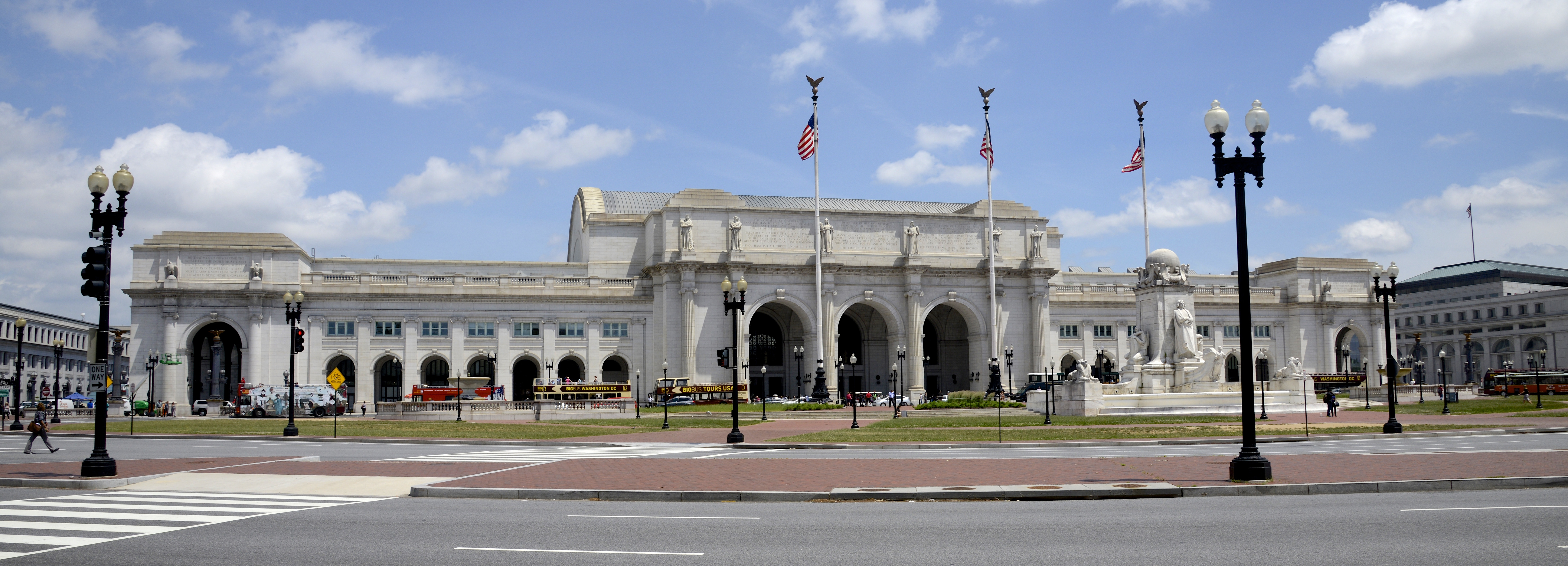
| | | | After Foggy Bottom/George Washington University, Farragut West, and McPherson Square (the middle syllable sounds like "fear') we arrive at a major transfer hub, the Metro Center Station (Photo by Ben Schumin). I've always liked the looks of this station because, while most stations have the coffered vaulted ceilings, in this case, the ceiling shows the actual N-S / E-W intersection that's occurring here. | | | | Our map shows we now take the red line past Gallery Place and Judiciary Square (where FS Key moved to) to the Metro station at Union Station (Photo by Ralf Roletschek), where the escalator (click) brings us right up under the portico facing the plaza outside.
https://www.visitthecapitol.gov/sites/default/files/styles/interactive-map-large/public/images/content/interactive-map/us-capitol-map.png?itok=4Bnpq3-3
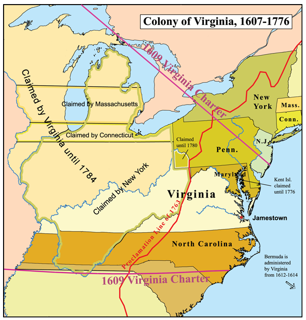
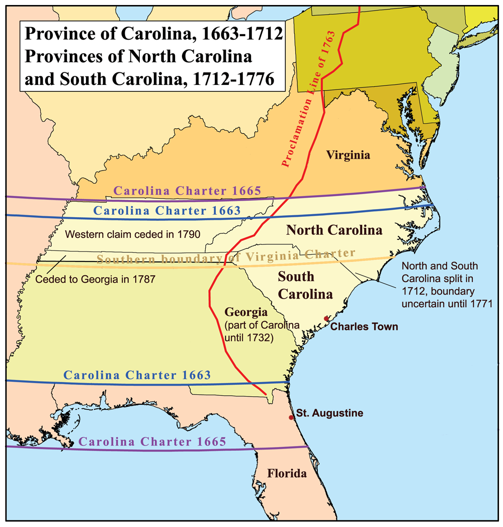
| | | | This is a nice local map (click) that I like which shows both the Metro station and Union Station, but also just how close both are down the few blocks of Delaware Avenue to the US Capitol and surrounding buildings of interest. Also, here's the familiar view of Union Station (Photo by VeggieGarden) as we discussed it in 2015/1 when leaving on the Capitol Limited to Harpers Ferry and way beyond. And when we step inside, the Great Hall (Photo by Marku1988) still looks as good as ever. | | | | We've now completed this side trip to the west of Chesapeake Bay, and we're starting the Charleston Rail 'n' Sail section of this trip between Baltimore and Charleston. This train trip on Amtrak's Palmetto, Train 89, is the rail half of that, although we're not actually starting in Baltimore (which we just recently passed through on the way to Ellicott City), but instead here in nearby Washington. We'll go south to Charleston SC, and will then return by ship from Charleston to Baltimore, completing the circuit. | | | | This map (click) shows what Amtrak calls its Silver Service (Map by jkan997) along the Atlantic coast from New York to Miami. The backbone of the service is two overnight trains with sleeping cars called the Silver Star and Silver Meteor, which run on staggered schedules and which I've used in the past. The Palmetto is the day train version of that, but which only has time to make it from New York to Charleston and Savannah. All three routes run together from New York to beyond Rocky Mount NC. Then the Silver Star takes the western route to Savannah. The Silver Meteor and Palmetto take the eastern route via Charleston to Savannah, where the Palmetto ends. After that, the Silver Star and Silver Meteor are again on the same route from Savannah to Miami. | | | | I had looked into the Silver Meteor, since I enjoy a roomette on a train. It leaves the north at convenient times, but arrives in Charleston at 4:51 AM. Thanks, but no thanks. The Palmetto leaves New York at 6:05 AM, and is not much better in Wilmington and Baltimore, one reason of many why I added the previous side trip, since leaving Washington at 10 is much better. The arrival in Charleston is scheduled for 7:19 PM, and could be late (it was). Still, I was able to transfer enough Starwood points to my Amtrak account so that I got three trips free on points--and in Business Class: the Palmetto, New York-Wilmington earlier, and Baltimore-New York at the end. So I'm quite satisfied. | | | | While the Capitol Limited left Union Station to the west, the Palmetto leaves it to the south in a tunnel under the Capitol Building, so that we once again get all the views of Washington monuments, and then cross the Potomac, stopping in Alexandria. In Business Class I had a seat with a large table for writing, but after a while, I got myself a plastic cup, and broke out the Vernaccia and cold gnocchi. They were almost as good as last night. I wrote and watched the passing scenery though VA, NC, and SC, to Charleston. | | | | As we ride along, since we recently discussed the colonial period around the Chesapeake between DE-PA-MD-VA, let's catch up further south. For a complete discussion, refer to 2009/21-25 titled "The Thirteen Colonies 1600-1800 I-V". But as we pass N-S through the length of VA, named for Elizabeth I, the so-called Virgin Queen, let's look at a map of the Colony of Virginia (Map by Kmusser) that we first saw in the VA discussion in 2009/22. As much as I like Cape Cod and Massachusetts, all that stuff about so-called Pilgrims that landed there in 1620 by accident on the way to Virginia has gotten blown way out of proportion. The First Landing occurred in 1607 at Cape Henry, now the southern one of the Virginia Capes leading in to the Chesapeake, and we'll visit it on the boat trip. That led to the settlement in Jamestown (see map) across the bay right afterward. VA had a huge claim up to the Great Lakes (eastern Minnesota could have been part of VA!), but that was altered after the formation of the US. But VA was still huge, reaching to the Mississippi, and included WV, as we've just seen, but also Kentucky, which finally broke away to become the 15th state in 1792, after Vermont broke away from New York to become the 14th. | | | | The establishment and settlement of the Colony of Virginia also led to the establishment and settlement to the south of the Province of Carolina. As you can see, the claims overlapped quite a bit. Let's now move to the map, first used in the Carolina discussion in 2009/21, of the Province of Carolina (Map by Kmusser). | | | | Carolina was first chartered by Charles I in 1629 and named for him. It was then re-chartered by Charles II in 1663 (see map) and turned over to eight English noblemen called the Lords Proprietor, as a reward for their help in restoring him to the throne. In 1665, the charter was revised slightly, extending the borders north and south. I would call the southern extension an in-your-dreams move, since it was an attempt to grab the Spanish city of St Augustine, and nothing ever came of that. But the northern extension was very interesting. Look at the Outer Banks area on the Atlantic, with the two large sounds it encompasses, which we'll visit on the boat trip. The southern one is Pamlico Sound, and was in Carolina from the beginning, but the northern one, Albemarle Sound, had been part of VA. But those residents had left the Colony of Virginia, and this adjustment sensibly moved the entire border, just to include them in Carolina, thus including all the waterways of the Outer Banks area within Carolina (today NC). | | | | Carolina has become a girl's name, but the name was based on Carolus, the Latin form of "Charles". Carolina was even bigger than Virginia, since it ran from VA to Spanish Florida, and from the coast to the Mississippi. But in time it split up into "coastal triplets" (my term). As the map shows, North Carolina, where the Province had been founded, and South Carolina split in 1712 due to disagreements between them. Note that SC, small today, reached to Florida, and was much larger than NC. Still, people to this day associate them with each other because of the similarity in name. Then in 1732, George II gave a corporate charter to the Province of Georgia, which was named after him. SC had been so large, that Southern South Carolina (my term, SSC) was the area that became Georgia, taking the largest part of what had been SC. Yet, since Georgia has a totally different name,\ making no reference to Carolina, people don't see it as one of the "coastal triplets". NC, SC, GA don't look alike, but NC, SC, SSC would have. | | | | As with VA, once these provinces became states, their inland areas became states as well. Inland NC first became the State of Franklin, then later, Tennessee. Inland GA became Alabama and Mississippi, each of which also later got access to the Gulf from Florida.
http://www.ezilon.com/maps/images/usa/south-carolina-physical-map.gif
| | | | We've been looking at those tilted maps, so here's the one for South Carolina, our train's destination for now. On the boat, we'll be sticking to the coastline from Charleston to Baltimore, so we probably won't need this after this. Just some comments. Here's a map we saw earlier. While we then went inland as far as the Blue Ridge Mountains in Harpers Ferry, those mountains affect SC only tangentially. And while the Piedmont is significant in SC, the Coastal Plain predominates, as it will all the way to Baltimore. But in SC and adjacent states, the term Low Country is used for the Coastal Plain, and that term and concept permeates the culture in and around Charleston. Now compare that map with the above SC map. | | | | The move of capital cities inland is typical for the East Coast. While Boston remains the capital of MA, NY's capital moved in from NYC to Albany, PA's from Philadelphia to Harrisburg, VA's from Jamestown to Williamsburg to Richmond, straight up the James River. As you look at our map, you'll see that SC moved the capital from Charleston inland to Columbia, and GA did so from Savannah to Atlanta. The odd-man out here is NC. No significant coastal cities ever developed there, so there was nothing to move inland, which is where the larger cities grew in the first place. | | | | Finally, although our boat ride will be from Charleston north, note the city of Beaufort SC to the south. There is an even chance you'll mispronounce Beaufort when you see it written, and to make it worse, there's two of them, and worse still, each uses a different pronunciation. There's this one in SC, and one we'll stop at in NC. One rhymes with "view" and the other rhymes with "bow [tie]". Here's the key: BEAUFORT: NC=BO, SC=BYU. | | | | Time moves along on a train when you keep yourself occupied. Once in SC (see map, and click), we make only three earlier stops, in Dillon, Florence, and Kingstree, and then Charleston. Sort of. Look close. As we'll see more extensively in the next posting, historic Charleston is on a peninsula between two rivers leading into the harbor. As a matter of fact, this central area is actually referred to as Peninsular Charleston. There was once historically rail service downtown, but today, Amtrak's Charleston Station is actually in North Charleston (see map), another municipality completely. When making plans, this fact was a complete turnoff, since I like immediate access between transportation and hotels, and I didn't want to hope I'd be able to find a taxi. | | | | So in advance, I checked limo services online, and found one with excellent writeups. When I called them before the trip to make a reservation, I was wary about late arrivals (the Palmetto actually arrived, not at 7:19, but at about 8:00 PM), but I was assured that they monitor planes and trains for lateness and arrive just before the real arrival time, which was the case. | | | | It was about a 20-minute drive from North Charleston down the peninsula to my hotel, which I'd chosen for its perfect location, location, location. It wasn't a cozy B&B, or a high-rise hotel. It was a plain old motel, a Days Inn. It had the typical parking lot with two levels of rooms around it on three sides. But it was comfortable, clean, reasonable, had a coffee shop next door, and the best location in town. The complete name said it all: Days Inn Charleston Historic District, and everything I wanted to do or see in Charleston was easily reachable over the next two full days before sailing. Exactly what that was will appear in the next posting. | | | | Boards & Ships In the previous posting, for the first time in years, we did an add-on Series article on Hameln and magpies. It's not that it was totally unrelated to the main topic, but the fact that Hameln is upstream on the Weser from Minden is hardly a strong connection. I don't necessarily plan to make a habit of this, but I've come across another language topic I like a lot that also has multi-language possibilities, and will include it here. If you need a thread to connect it, this topic deals with ships, and after Charleston we're taking a ship. Works for me.
| | | | Once I got going on this, I got a lot of information from the Online Etymology Dictionary, a frequent source, but extensively modified what I found there. Friend and boating enthusiast Carter acted as an email consultant on a pivotal issue, steering (does that make the use of "pivotal' a pun?). As ever, information and pictures came from Wikipedia, both English and German, and clarifications were necessary from the Portuguese, Italian, French, and other versions for verification. Where else would I have found the corresponding Icelandic words? Although it helps, you don't always have to speak the language to be able to get valuable information online. | | | | The following story is most appropriately told on a ship, but it works here too. I know I told it at least once, maybe twice, years ago at dinner on the Queen Elizabeth II on a couple of transatlantic crossings (see below).
There once was a very famous, internationally known Captain who had served on many of the biggest and finest ocean liners, where everyone admired and respected him. The Captain's First Mate hoped he could learn from the Captain so he could rise in his own career, so he was happy when he discovered something that might help him. He'd noticed that, once a week, the captain would go into his office, sit down at his desk, open the drawer, and take out a little wooden box. He would then lift the lid and take out a card. After studying the card for a few moments, he would put everything back until the next week.
The First Mate was sure this was something essential to the Captain's success that could also help him, so one day when the Captain was ashore, the First Mate stole into the Captain's office, sat down at the desk, opened the drawer, and took out the little wooden box. He lifted the lid, took out the card, and read it. It said:
| | | | | | Port: left | Starboard: right |
| | | | I also know I once told the story in German at a dinner table of German speakers on the late, lamented Deutschland sailing somewhere. I won't repeat the whole thing, but the punch line was: | | | | | | Backbord: links | Steuerbord: rechts |
| | | | The story works well because lay people in all languages wonder why maritime terminology such as this is so arcane in all languages, and why they have to spend extra effort to learn the distinction, usually by some mnemonic device. I learned it years ago, and I remember I first figured how to remember the difference this way. Both "port" and "left" have four letters; that means "starboard" must be "right". German Wikipedia suggests using alphabetical order: links comes alphabetically before rechts just as Backbord comes before Steuerbord. French Wikipedia gives a number of suggestions. The one I like best is to match the second letter of the appropriate words, that is, the As in gAuche=bAbord and the Rs in dRoite=tRibord. It's a mess for everybody! Except the Italians. They've cleared away most of the confusion within Italian. Stay tuned. | | | | Boards I started out seeing where the terminology had come from and what the words were in various familiar languages, using German Backbord and Steuerbord as a crutch to better understand English starboard, earlier larboard, and Old English bæcbord. But research into that surprisingly brought forth an equally interesting (perhaps even more interesting) origin to the second element, –board or -bord, and we really have to start with that. | | | | We need to begin way back. Remember that our language family is called Indo-European (IE), and that Germanic, Latinate, Slavic, and other groups are subfamilies of that. Also keep in mind that words we come across in IE have been reconstructed by historical linguists from later forms, and since there's no written proof of them—with no writing that far back, how could there be?—any words in IE and other reconstructed languages have to be written with an asterisk to show that they're theorized forms. | | | | We start with the Proto-Indo-European verb *bherdh- "to cut", from which developed the noun *bhrdh- "board". The oddity we have is that two separate forms developed out of that in Proto-Germanic, both *burdam and *bordaz. Discounting the endings, they're similar, right? In German they each developed into two clearly distinct words, Brett and Bord respectively, but the further oddity we have to deal with is that in English, they both developed into exactly the same form, "board" (even in Old English they'd fallen together as "bord"), so we're going to have to number them here as BOARD¹ and BOARD². The further problem is that both meanings (in both languages) are still wood-related, resulting in the two English words sometimes being confused for each other. I understand there are even some sources that contend they're the same word, but we can point to both the etymology and the two different German words to show they're different. | | | | BOARD¹ Proto-Germanic *burdam developed into BOARD¹ with the meaning of plank, cut piece of wood as follows. In Old English it became bord, with the same meaning. In Old Norse it was borð (ð, the letter edh, is like the TH in "this"; see 2012/13), in Dutch bord, in German Brett (as above). But surprising things happen in language, reflections of human imagery. By late Old English bord was extended to also mean table, logical, since most tables were made of wooden boards. (Compare what happened with the Old Norse word in Swedish smörgåsbord in its original meaning of "appetizer table".) Then, in the 1610s, English developed "above board" (honest, open) in the sense of "keeping one's hands on the table" in contrast to under-the-table dealings.
| | | | Human imagery doesn't stop so easily, but jumps from theme to theme. OE bord was further extended in the late 14C to mean food, which is of course, found on a table. (Again compare Swedish smörgåsbord which added the additional meaning "food on an appetizer table", which is the only meaning that was borrowed into English.) With this extension, English developed the phrase "room and board"; and, from the 1530s "boarding" (supplying of food & lodging), which led in the 1670s to "boarding-school" and in 1728 to "boarding house". | | | | And there was still more: bord was extended in the 1570s to refer to a council table, hence "boardroom"; then further extended in 1610s to leadership council [that meets at such a table], hence "board" [of directors]. So historically, the (wooden) table gave its name to the room and to the people, while we today picture the complete reverse. | | | | BOARD¹ also developed into verb forms: (1) from the "plank" sense, in the late 14C: "to put boards on, cover with boards," (as in "boarded up"); (2) from the "food" sense in the 16C: "to be supplied, or to provide, with food and lodging", hence, in the 1520s, "boarder¹" (one who has food and/or lodging at another's house). | | | | There are numerous compounds with BOARD¹ in the sense of a plank, and this list is not necessarily definitive. Some of the following are still wooden, others not. As the first element we have boardwalk; otherwise: chessboard, storyboard, springboard, diving board, chalkboard, blackboard, whiteboard, signboard, switchboard, washboard, baseboard, clipboard, wallboard, keyboard, ironing board, control board, floorboard, fingerboard [of a violin], headboard & footboard [of a bed]; buckboard (simple open carriage); sideboard (dining room serving table); cardboard (earlier "card paper"); pasteboard (made of sheets pasted together); billboard (Am Eng) (signboard for bills [notices]). Billboard magazine, founded in 1894 and known for its pop music charts, was originally a trade paper for the bill-posting industry. | | | | Finally, we have some compounds that are particularly interesting:
cupboard: 14C "a shelf for cups", altered in the early 16C to "closed cabinet", now KUB.erd
dashboard: 1846 "board in front of a carriage to prevent mud from being splashed ("dashed") inside from the horses' hoofs"; as of 1904 "front panel of an automobile, as a control board"
shuffleboard: from "shovel" and the act of shoving; originally a tabletop game c 1600 that grew large-scale in 1877 for ocean liners
mortarboard:"academic cap", so-called because it resembles a mason's square board for carrying mortar
bordello (also used here as the first element in the word)
from Frankish *bord "wooden board"
then Old French borde "hut made of planks"
then Old French 12C diminutive bordel "small hut, cabin; brothel"
to English c 1300, at this point as bordel "house of prostitution", now obsolete in English
then French bordel was borrowed into Italian as bordello
it was then borrowed a second time into English in its Italian form with -O by the 1590s; the Italian form with –O went only into English; otherwise GE Bordell, SW bordell, DU bordeel
| | | | | | As for Frankish (above), remember that the Franks were a Germanic tribe that spoke Proto-Germanic and settled in France after the Romans left. They largely adopted the local language, but strongly influenced Latinate French with their Germanic roots. Frankish became Old French. |
| | | | BOARD² Proto-Germanic *bordaz developed into BOARD² with the meaning of side of a ship. In Old English it was bord (just like the one above!) "side of a ship; border, edge, rim"; in Old Norse it was barð (compare borð above); it was also the source of Dutch boord, German Bord (as above). But notice the imagery of the side of the ship being also being the edge of the deck, its border. So then border (edge, frontier) appeared. While it definitely came from BOARD², it might have come down from Proto-Germanic in one of two ways. (1) It might have been an extension from Old English bord "side of a ship; border, edge, rim" as above, or (2) it might have come from Frankish *bord, then into Old French bordure "seam, edge of a shield, border", then to English as "border", in the mid-16C.
| | | | BOARD² developed into verb forms as well: (1) from the "side of a ship" sense: "to come alongside" [a ship], in the mid-15C; "to get onto, enter" [a ship], in the 1590s; hence, from 1769, "boarder²" (one who boards a ship, particularly an enemy); both "to board" and "boarder²" were transferred, in reference to passengers as of the mid-19C, from ships to stagecoaches, railway cars, and aircraft; (2) from the "border (edge, frontier)" sense c 1400, "to put a border on"; 1640s, "to lie on the border of", also "bordered", "bordering". Note the spelling difference between "boarder" (either as a lodger or as someone boarding a ship), and "border" (edge). | | | | Words based on BOARD² referring to the side of a ship are particularly obvious:
overboard
outboard, inboard
on board
aboard, via Old French à bord (on board)
shipboard (occurring on a ship)
seaboard (originally, just the seaward side of a ship when in port; later extended to the seaward side of a land mass, hence coastline, as in the Eastern seaboard)
starboard, and the former larboard and bæcbord will be discussed separately below, as will German Steuerbord and Backbord.
| | | | Since one "board" refers to wood and the other to ships, originally wooden, one can see how the two became confused early on, where even Old English had the one form, bord. But the two etymologies are clearly different, and the following German examples show how the two streams of meaning are clearly apart outside English. | | | | How *burdam and *bordaz came down from Proto-Germanic to German amazes by its simplicity compared to the complex English development. The former stayed with wood, and the latter stayed with ships. | | | | As mentioned earlier, *burdam, referring to wood, became (1) (das) Brett (board, piece of lumber). If you don’t see the similarity to English, note this. While BOARD is B[vowel]RD, BRETT is BR[vowel]T, and those final sounds, B and T, are twins, the first being voiced, the second voiceless. Brett is the usual word for "board" as in Sprungbrett / springboard, Schachbrett / chessboard. Idiomatic is schwarzes Brett, literally black board (two words)—it's a bulletin board or notice board, not something to write on. But it also developed into (2) (das) Bord (board), with fewer uses. It refers to a (single) shelf somewhere, where a Regal implies several, as in Bücherregal "bookcase"; however, a single shelf within the latter is a Regalbrett! | | | | On the other hand, *bordaz, referring to ships, became (der) Bord (side of ship; edge). What a difference gender can make! The previous Bord was neuter, using das, but this word is masculine, using der. As in English, the use of this word is usually obvious: someone an Bord a ship might fall überbord; one boat might have an Innenbordmotor, but another might have an Außenbordmotor (ß=ss). Yet there are also some special uses. Staying with the side of ship theme, the word can be emphasized by adding (die) Wand "wall", becoming Bordwand, literally "shipside wall". In other words, that guy that fell überbord fell über die Bordwand ins Wasser. But the word also refers to an "edge" in Bordstein "curbstone", literally "edge stone", and in heraldry, a Bord is a border around a coat-of-arms. | | | | Ships The above about boards being resolved, we can now get to the original purpose of seeing how BOARD² "side of a ship" further developed into "starboard" and the former "larboard", and even earlier "bæcbord". Also discussing German Steuerbord and Backbord will help us as a guide. Just as we were doing derivations from Proto-Germanic earlier, you'll find the whole left-and-right system on ships is of Germanic derivation, spreading to all Germanic languages, and then to the Latinate languages.
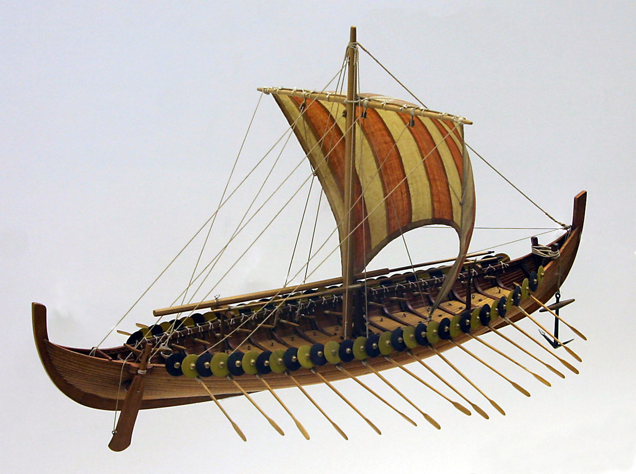
| | | | Understanding the right-hand side (facing forward) is far easier, so we'll start there. It's all about (1) steering, and the fact that (2) most people are right-handed. Modern ships use a rudder in the centerline of a ship. For our purposes, disregard that. In ancient Egypt, Rome, and China, steering paddles were used, and the helmsman would be located at the stern, directing his paddle. Let's concentrate on that. | | | | But in northern Europe, the Vikings developed their longship. It was canoe-like, in that not only did the bow come to a point, so did the stern. So where was the helmsman to use his paddle? He had to locate himself slightly forward from the sharp point of the stern and thus paddle from the side of the longship. Which side? Most people are right-handed, so the right side developed as the steering side. Eventually, the paddle was physically attached to the right side, and the right side fully and thoroughly became the "steering side". For this I refer to this illustration from the Bayeux Tapestry (Photo by Urban) in Normandy showing the helmsman steering a Viking longship. (Refer back to 2012/15, Ctrl-F "Bayeux" to review the Vikings in Normandy and the Bayeux Tapestry; there's a link there to a wide panorama of the tapestry showing several examples of helmsmen steering.) In addition, German Wikipedia showed this image of a model of the Gokstad ship (Photo by Softeis) also clearly showing the steering paddle on the right side of the ship, and attached to it. This ship was a late 9C Viking ship discovered in Norway in 1888 and on display in the Vikingskiphuset (Viking Ship House [Museum] in Oslo. I was at that museum years ago which has several Viking ships, and must have seen it, although I was (blissfully) unaware about side paddles then. | | | | Proto-Germanic *steuro was "a steering". It's easier to see in German, where steuer[n] (SHTOI.er[n]) is "to steer" and so Steuerbord, on the right, is the "steer[ing] side". Dutch is "stuurboord"; and it was the same in English: Old English steor "rudder, steering paddle" became Old English steorbord. | | | | It's really quite remarkable how steorbord got altered to starboard, since it has absolutely nothing to do with stars. I can only speculate again: could it have been a playful pronunciation, or an effort by mariners to develop an arcane nautical jargon recognizable mainly to them? If that's the case, it worked, since laymen today don't necessarily understand the word. And then, maybe it was just a normal language development. | | | | | | It's definite that "starboard" comes from the second (BOARD²) reference to the side of a ship. But to show how confusion can develop in language, a steering paddle of this type can also be called a steering board. In that case, the latter phrase has to be based on the first (BOARD¹) reference to a plank! The use of a so-called steering board on the starboard side amounts to a purely coincidental use of both words at once. |
| | | | Understanding the left-hand side is more complex. For English, it occurs in three successive versions, in German only one, so again, it's easiest to start with German. If the helmsman was giving his all with both hands on the right side using the steering paddle, then his back was turned to the left side. The Proto-Germanic word for back was *bakam, and thus the German name—to this very day—for the left side is Backbord, and the very first English name, based on Old English bæc "back", was bæcbord. This is the form used today (in variations) in most European languages, not only Germanic ones, but also Latinate. | | | | You may object to the above point if you know that the German word for "back" is Rücken, that it appears in the form Rucksack, and is borrowed into English as "rucksack" and used alongside the native "backpack". Nevertheless, (die) Back is a very old word in German that appears in dialects and idiomatic expressions. But the nautical use is the oldest, having become part of Backbord in Viking times. I'm surprised to find that Back is also the word in German for a forecastle, and also for a table in the officers' wardroom. Forecastle, pronounced FOHK.sul and often spelled fo'c's'le, is a structure on the front of a ship; a wardroom is a dining room/living room for ship's officers. | | | | | | FLASHBACK THREE: I'm well aware of what a wardroom is, and for that I have to refer back to 2013/7, which summarized the Fifty Voyages I'd taken between 1957 and 2012, since increased (and duly updated there). You'll note that Voyage 43 in 2008 on the QM2 was my 19th Atlantic Crossing, and 6th on the QM2. (A total of 19 continues to startle me.) But instead I refer earlier on that list to Voyage 20 in 2000, the 6th Crossing and the 1st on the QE2, and then, earlier still, to Voyage 27 in 2003, the 13th Crossing and the 7th and final one on the QE2.
That first QE2 trip was the beginning of our Third Travel Cycle described in the very first listing on this website (2000/1) the cycle that continues to this day. We were impressed enough with the QE2 that we traveled on it seven times, tightly concentrated between 2000 and 2003. That degree of concentration surprises me, too. In any case, the QE2 had a custom of using certain tables as "hosted tables" in the dining room, which meant that a ship's officer would dine with the passengers at that table for the length of the crossing. I don't know how we fell into getting assigned to one of those tables that very first time, which happened to be the Engineers' Table, but friends we made at the table suggested that they always asked for the Engineers, because they were the most fun officers to be with, and we continued to do that regularly. The conversation around that table was always outstanding, and a bonus was that the officer host always treated the table to several bottles of wine.
Later in the voyage, selected passengers at hosted tables would get a written invitation to join all the officers at an evening reception in the Officers' Wardroom, which was packed to the gills, yet a very enjoyable experience. I also have a memory of officers helping to maneuver Beverly's wheelchair up some steps to the wardroom. Nice guys.
|
| | | | English is the only language that went two steps further, so now the English designation shifted into its second phase. Since the all-important steering paddle was on the right/starboard side, to avoid damaging it when docking, the ship would pull up to a wharf or pier on its left side for loading and unloading. Thus the now obsolete term larboard developed to mean "left-hand side of a ship", because that was the "loading side". | | | | The verb "to lade" still exists in English alongside "to load", with the same meaning. But while German and Dutch still use laden, in English "lade" is now disappearing in favor of "load". But there are at least two exceptions. It remains in the adjective "laden [with gifts]" (loaded down, burdened) and "bill of lading", a written statement of what was loaded. In Middle English it had the form "laden", and c 1300 the name of the "loading side" developed into "ladebord". But remarkably, in the 1580s it was altered to "larboard". | | | | If it's hard to picture how steorbord was altered to starboard, it's even harder to understand the appearance of larboard. It's usually explained that it was altered specifically to rhyme with starboard. Perhaps this was a further effort to form a nautical jargon, an inside term used among mariners, but that is speculation. | | | | But larboard was willfully killed because of its own success. Having two opposite words that rhymed, while it might be fun, might also make it difficult to distinguish the two, particularly in emergencies, and accidents could result. In 1844, the British Royal Navy forbade the use of the word larboard, and in 1846, the US Navy followed, and the word died out completely. To replace it, the thinking was, if the ship at the pier was being loaded on its left side, that meant that the left side was facing the port, and so the authorities then declared that "port" be used for the left side, putting English totally out of step with all other languages. However, "port" had already been in use since the 1540s as an alternate term—now it was the only term. In 2016/11 we talked about the derivation of "port" coming from Latin, so its heritage stands out among all the Germanic terms we've been discussing. | | | | Other Languages Let's also look around at other languages, but as ever, separating and comparing the Germanic and Latinate ones. The Germanic languages (except English) follow the Germanic model:
German: Backbord & Steuerbord
Dutch: bakboord & stuurboord
Swedish & Norwegian: babord & styrbord
Danish: bagbord & styrbord
Icelandic: bakborði & stjórnborði
| | | | In 2016/11, we discussed how the Dutch word haven (harbor, port) moved down the coast to become a French word, and also the name of the city of Le Havre. We now have two more examples of Germanic words appearing as loan words in Latinate languages, and again, they're both from Dutch, into French first, then spreading to the others.
French: bâbord & tribord
Catalan: babord & estribord
Spanish: babor & estribor
Italian: babordo & tribordo
| | | | (Note that Swedish & Norwegian both use babord, without the K, probably copying French.) But the point is that, how Dutch bakboord moved into these forms is obvious, with them dropping the K, but stuurboord less so. That's because it was not the Modern Dutch form, but Middle Dutch that loaned its form, which was then stierboord; stier in Old French became estiere, and the whole word in Old French was estribord. That pretty much remained in Catalan and Spanish, but reduced further in French, which Italian borrowed. | | | | However, these terms in Italian have now quite sensibly been declared obsolete in favor of pretty much just calling a spade a spade, that is "left" and "right". Those words in are, respectively, sinistra and destra. As in all Latinate languages, they are feminine in gender to correspond to feminine mano "hand", so you're actually implying "left-hand" and "right-hand". Anyway, sinistra has successfully become the Italian nautical term for "left", although destra didn't quite make it—instead dritta is used for the right side of the ship. Still the two are a bit similar, and it's far easier in Italian to learn which is which. | | | | But I was still curious a to just what the origin of dritta was, and a little digging was enlightening. Let's work backwards. It's the feminine of dritto, since it has to imply "right-hand"; that in turn is a contracted form of diretto, which is both the adjective "direct", but more importantly, the past participle of dirigere, "to direct, to guide, to keep straight, to manage"—and—"to steer". Ta-da! Italian now uses its word for left nautically, but that right side remains the steering side! | | | | Finally, you may have noticed that I've left one language out:
Portuguese: bombordo & estibordo
While the second word falls in line with the others, it's that first word that's the cute oddball, so I consulted Portuguese Wikipedia. Here's the result, with my translation:
| | | | | | Bombordo é o bordo à esquerda do rumo da embarcação. Este nome vem do facto de os navios ao descerem o Atlântico ao longo da costa africana terem à sua esquerda a terra e os respectivos portos pelo bom bordo. | Bombordo is the left side in the direction of the vessel. This name comes from the fact that the ships going down the Atlantic along the African coast had on their left the land and the respective ports as the good side. |
| | | | How typical of Portuguese history, sailing down the coast to the ports of Africa, where the bom bordo, the Good Side, is the bombordo or left side. Wait! that's just like once again calling it the port side! | | | |
| |
|
|
|

