|
Reflections 2017
Series 2
January 12
East Coast XII: Baltimore – Stagecoaches to Train Coaches
| | Day 18: Baltimore 1 The American Star spent the night docked right in St Michaels, since the distance to Baltimore was so short. The original schedule without St Michaels would have gotten us in at 8 PM, ready to disembark the next morning, but now we'd be getting in after lunch, allowing plenty of time this first half-day, so there was no rush to get started out of St Michaels.
http://battleforbaltimore.weebly.com/uploads/1/7/4/2/17423695/9706568_orig.jpg
https://www.nps.gov/nr/twhp/wwwlps/lessons/137fomc/137Images/battleofbaltimore.jpg
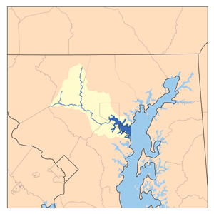
| | | | For the moment, we can stick with our historical "blue map". This shows that it would have been the night before arriving in St Michaels that we'd already passed the Potomac and Patuxent estuaries where the Bladensburg/Washington action had set out from. As we pass Annapolis today, we go under the contemporary Chesapeake Bay Bridge we discussed, but then head right into the estuary of the Patapsco, right past North Point where the soldiers had left from. Now move to the Baltimore detail map. We sail right through the location of the Main British Fleet, with Key's truce ship to our right. We sail right through the location of the British Bombardment Fleet, and where the sunken hulks had been. We note where the British tried that other landing, as we sail past Fort McHenry and into Baltimore's Inner Harbor. How cool is that! Just as with the Norfolk sailaway, this sort of historic association can be appreciated only from a ship. | | | | Now let's leave that historic reverie and look at things today. This is the 63 km (39 mi) Patapsco River, with its watershed (Map by Karl Musser). We last encountered it in Ellicott City (2016/12), located on its Western Branch. The river is rather small there, although subject to flooding (after our visit in May, it did so, severely, on 30 July), but its estuary widens considerably, typically so for the Chesapeake area, forming Baltimore's harbor. (On this map, Baltimore is that Nevada-shaped entity.)
http://f.tqn.com/y/dc/1/S/O/X/2/Patapsco.jpg
| | | | This map shows the Patapsco, surrounded by greenery, swinging around and entering its estuary, counterintuitively, from the south. This section is called the Middle Branch, and is where that failed midnight landing took place. Above that is the Northwest Harbor, leading to downtown Baltimore and its famous Inner Harbor, once called the Basin. At the entrance to the main harbor, Fort McHenry is in that green area to the left, and I-95 goes under it via the Fort McHenry tunnel we took earlier. Next to it is the Baltimore Harbor Tunnel with I-895, so there are no bridges to block the views in this historic intersection. Finally, the next crossing, with I-695, IS a bridge, and, since Key's truce ship had been located just south of adjacent Sparrows Point, this is the Francis Scott Key Bridge, the one in Baltimore, just as there is a Key Bridge in Washington, adjacent to the site of his former home in Georgetown. | | | | The Grand Entrance I have memories of approaching big cities by car, train, and plane. Occasionally, you can get good arriving views from all modes, depending on the location. But there is nothing like making a Grand Entrance to a city on a ship. The next best thing is a Grand Sailaway, but leaving is a negative emotion, where arriving portends the future. The best Grand Entrance by ship is into New York Harbor, which is why they positioned the Statue of Liberty just where they did. I've also had two memorable sailaways from Hamburg going quite a distance down the Elbe, on the Queen Mary 2 in 2006 and again in 2008 (2013/7). And the Norfolk Sailaway we just had ain't chopped liver, either. | | | | But for some reason I can't imagine when I reflect back, I hadn't been expecting too much of the Baltimore arrival. Silly me. I should have known better, especially once I noticed the perfect weather we were having. I'd now classify it as not only one of the best parts of this trip, but among the most enjoyable ship arrivals I've had. After lunch I went up top to the roof. Some ships call it the Sun Deck, here it was called the Observation Deck, but if you call a spade a spade, it was the roof, which had two large sun shades over tables and not much more. It was well before happy hour, so the boozers had no excuse to be no-shows, and we'd just had lunch, so the chowhounds were satiated. But, while we were a good-sized crowd, much better than in Norfolk, there were still fewer passengers up top than I'd have expected. To each his own. | | | | Lecturer Dr Harold Cones had taken up a position under the front sunshade and added substantively to the atmosphere of the Grand Entrance. He pointed out the location of Key's ship, Fort McHenry, and commented on sights left and right all the way into the Inner Harbor up to our dock.
http://preservationmaryland.org/wp-content/uploads/2016/05/FortMcHenry_ROW12090648921_th.jpg
| | | | This is a turned-around aerial view looking SE over Fort McHenry on Locust Point showing the entry channel to Baltimore. Baltimore is to the left, so we were going in the opposite direction from the ship shown. This next view of Baltimore Harbor is pointed in our actual direction. We're coming from the right, and to the left is the Middle Branch. We turn right at Fort McHenry into the Northwest Harbor then slowly and majestically, wend our way past Canton, Fells Point (a great discovery for me—see below), and in to the Inner Harbor. While Baltimore has been a major US seaport since the 18C, water depth was a problem from the beginning. For that reason, areas further out developed harbor facilities, including Locust Point, Canton, and Fells Point. Later, the Inner Harbor was dredged, adding to its capability. | | | | When a historic harbor city dating from colonial days has a neighborhood named Canton, only one thought should pop into one's mind, the China Trade with Guangzhou/Canton discussed in connection with the colonial port of Salem MA in 2014/2. It turns out that this neighborhood fits in, but indirectly. In 1785, a Baltimore merchant started trading with China, and when he established a plantation, he named it Canton. This neighborhood then took the name of the plantation, not Canton directly, and later became commercial and industrial, although today it is gentrifying.
http://baltimorewaterfront.com/wp-content/uploads/2015/01/Waterfront-Walking-Map.jpg
| | | | The Inner Harbor We'll use this excellent Inner Harbor map to concentrate on our central area of activity. Click, and it will expand exponentially. On the south shore we see Locust Point going out to Fort McHenry that we just passed, and also the Federal Hill neighborhood, looking down on the Inner Harbor. On the north shore we see Canton, but will concentrate on Fells Point and the neighborhood called Inner Harbor. We now note that, just as Hampton Roads refers to a waterway, but also to the cities on the land area surrounding it, the same is here. The Inner Harbor is the waterway west of Fells Point, but also the neighborhood around that waterway, surrounded here with a red line. The sub-neighborhood called Harbor East is actually short for Inner Harbor East. | | | | I always wondered why, if the Patapsco entered way to the south of the Middle Branch, the Inner Harbor even existed, and on this trip I found out. There is a stream I got to see with the unusual name of Jones Falls (Photo by Onore Baka Sama)--it must include a waterfall somewhere!--that runs 28.8 km (17.9 mi) from Baltimore's northern suburbs, forming a rail and road transportation corridor, and emptying into the Inner Harbor. On our map, it exits from under President Street and appears just to the west of it, looking not like a stream but like little more than a docking area between piers. | | | | On our map, at the innermost part of the Inner Harbor, click to find the observation level of the World Trade Center (not named). This is the view from there to the southeast down the harbor (Photo by Iracaz). Click to find the Key Bridge way in the distance, and then you can imagine our stately, winding route towards the camera past Fort McHenry toward the glass pyramid-roofed National Aquarium in the foreground (also on the map). In the middle view on the right just the barest edge of the Federal Hill neighborhood can be seen—which I've visited in the past—and opposite it on the left is a tiny, round, red building. I never did visit this, since I only learned of its existence after the trip. | | | | In our above discussion of screw-pile lighthouses, I said we'd be seeing this one later, and here it is. It’s the Seven-Foot Knoll Light (Photo by VinceB), built in 1855, making it the oldest screw-pile lighthouse in Maryland. It was originally located on a shallow shoal, Seven Foot Knoll, at the mouth of the Patapsco:
https://www.tide-forecast.com/tidelocationmaps/Sevenfoot-Knoll-Light-Maryland.10.gif
| | | | In 1875, the original house on top was replaced with the current cylindrical structure made of wrought iron plates. It was seriously damaged by ice in 1884 and 1894, automated in 1949, and deactivated in 1988, and later moved here. While its unusually colors and "tin-can" style have to be quite unique, do note how here, the staircase that had to be added for visitor access (click) is ultra-discrete, in contrast to the one in St Michaels. By the way, my Cousin Joe, an engineer, has since informed me that "screw piles are still an integral part of supportive construction; today they are called helical piles".
http://images.fineartamerica.com/images-medium-large-5/seven-foot-knoll-light-baltimore-inner-harbor-christiane-schulze.jpg
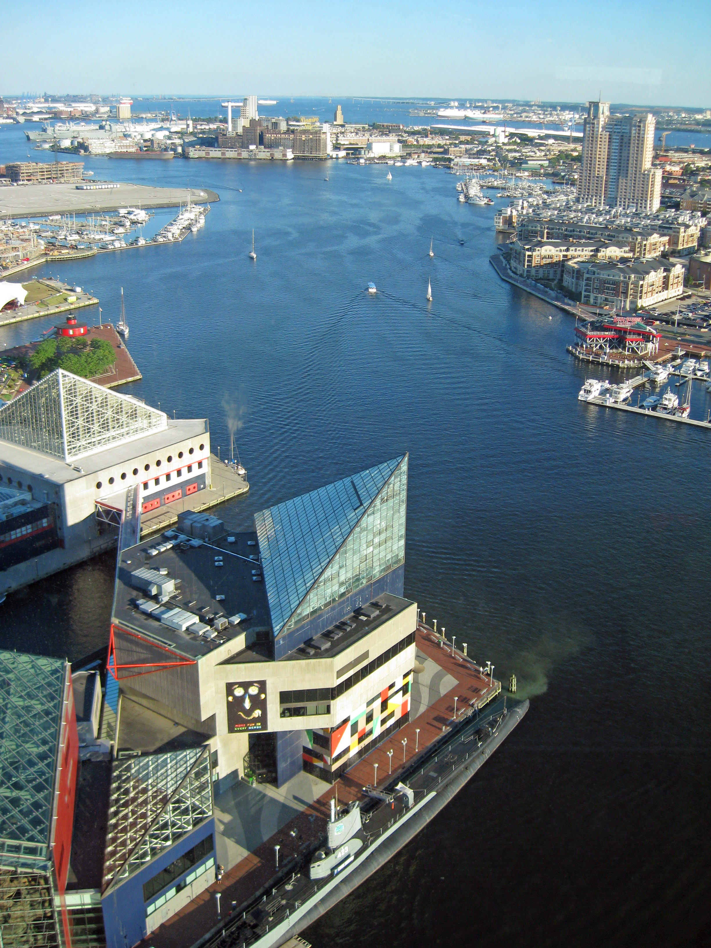
| | | | This is a pleasant view from the lighthouse across the Inner Harbor to Federal Hill and Federal Hill Park, and this is the reverse view down from Federal Hill Park (Photo by Iracaz). Click to inspect the lighthouse on the right and the aquarium on the left. At the left edge is half of the tall World Trade Center, from whose deck we just saw a view. | | | | Go back to our map to see how marvelous our arrival was. It had been announced that we'd be docking "near the aquarium", which wouldn't have been bad at all, but as it turned out, we went even a bit further. We docked on the right side of the innermost dock in the Inner Harbor. Not only that, on the left side of the dock was a historic ship, the USS Constellation. Magnificent. When finding a place to stay in a city I always use the real-estate mantra "location, location, location". The only way we could have had a closer location in as large a city as this would have been to have plowed into Pratt Street to our north or Light Street to our west, two of the main downtown streets. On reflection, this might have been the best big-city docking location I've ever experienced. To equal it in New York, you'd have to dock in Times Square abutting the George M Cohan Statue; in London, you'd have to dock in Trafalgar Square at Nelson's Column. Even in Charleston, the ship was a little ways across town; in Wilmington NC, we couldn’t use the downtown dock, and even so, that's a much smaller city than Baltimore. St Michaels had good docking, but that's a really small town. Here, things were perfect for a big city. | | | | This view to the west is roughly from the aquarium and shows the side of the pier with our docking space, still empty (Photo by Gabriele Zanatta). Click to see the museum building on the dock itself for the USS Constellation, which is on the other side. One block further west still is the Hyatt. Look immediately to the left of the white Hyatt logo. The brown rooftop one block behind it is of the Sheraton Inner Harbor Hotel, with barely half of its S logo visible. That's where we stayed there for the 2nd and 3rd nights in Baltimore. | | | | This is a close-up of the front of the USS Constellation (Photo by Smash the Iron Cage), with its museum and the aquarium in the background. Unfortunately, the masts here were apparently being worked on, so let's also use this rear view (Photo by 350z33) showing the complete masts (click). The Constellation was built in 1854, commissioned in 1855, and is described as a sloop-of-war/corvette. She remained in service for about a century, before being retired in 1954. | | | | We have one final harbor view, this panorama of the Inner Harbor (Photo by Brlaw8). It's either taken from Federal Hill, or from a tall building next to it. Click to inspect on the left the extensive park areas along the water's edge; below the whitish building is the Constellation and our dock for one night; the World Trade Center; the Aquarium; further down the lighthouse; to the right of the white tents, the entrance of Jones Falls is barely noticeable; the tall buildings are in Harbor East. | | | | Baltimore Essentials In 2016/10 we talked about Captain John Smith, a leader of the Virginia Colony based in Jamestown, exploring the rivers of Virginia and Chesapeake Bay. A copy of his 1612 map is included there. In 1608 he traveled north, leading the first European expedition of the Patapsco River. Some years later, English colonists began to settle Maryland, and the area that today is metropolitan Baltimore was first settled by them in 1661.
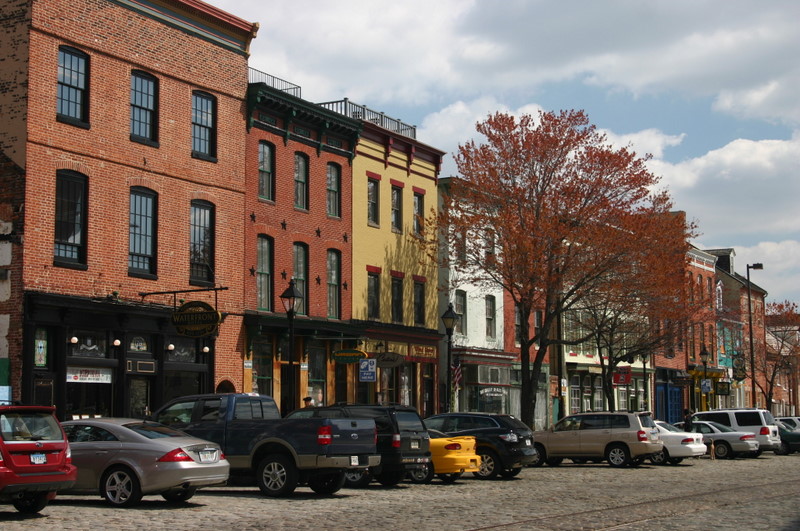
| | | | Baltimore itself was founded in 1729. It's named after Cecil Calvert, second Lord Baltimore, a member of the Irish House of Lords and a founding proprietor of the colony and Province of Maryland. The name derives from the family estate in Ireland, Baile an Tí Mhóir, Irish Gaelic for "Town of the Big House". I suppose this is a good place to add that locals today have two pronunciations of the name, usually depending on the part of town they're from. Some say Baldimore, which is an alteration of only one sound. But others lose the whole central syllable, and say something like Balmer. I once had a teaching colleague from Baltimore, and she first alerted me to the latter pronunciation, which she forced herself to drop while she was teaching in New York. | | | | But by the beginning of the 1970s, Baltimore's Inner Harbor was being neglected and was occupied by numerous abandoned warehouses. In 1975, the nickname "Charm City" was invented to improve the city's reputation, and renewal and redevelopment began. Almost all of the beautiful development we've just seen around the Inner Harbor dates from then, including (check the map) the 1976 Maryland Science Center (#8), the 1977 World Trade Center; the 1979 Convention Center, two blocks west on Pratt Street; the 1980 Harborplace Mall (#7); the 1981 National Aquarium (#6); and the Baltimore Museum of Industry (#9). The redeveloped Inner Harbor has been described as "the model for post-industrial waterfront redevelopment around the world". | | | | Baltimore is home to some of the earliest National Register historic districts in the US, including Fells Point in 1969, Federal Hill in 1970, and Mount Vernon Place in 1971. It has 289 individual properties on the National Register. Combining those with the historic districts, Baltimore has more public monuments per capita than any other US city. About a third of the buildings in the city, more than 65,000 properties, are on the National Register. While I don't usually list famous people from a place, there are many here, and I chose to name Edgar Allan Poe, HL Mencken, and Babe Ruth as being from Baltimore. | | | | We talked about single houses in Charleston at one end of this boat ride, and we have to mention, at this end, Baltimore's famous rowhouses. In the mid 1790s, developers began building entire neighborhoods in the British-style rowhouses, which became the dominant house type of the city early in the 19C. City streets are lined with tens of thousands of these, defining Baltimore more than any other US city. Early examples of the style, some retaining their early features such as white marble steps, as seen on this 1900-1910 postcard, are still standing in the Federal Hill and Fells Point neighborhoods. But rowhouses can be found in various states of repair across the city, some being abandoned and boarded up. | | | | However, there is one aspect of the rowhouses that disturbs preservationists. Rowhouses are typically built of brick, but many have been covered in formstone, a simulated masonry facing, sort of a stucco veneer. Formstone facings were patented by Albert Knight of Baltimore in 1937 and are now a common feature on Baltimore rowhouses. It was sold as an low-expense, low-maintenance alternative to be applied to the brick façade. It gave a stone-like appearance that could be shaped into different textures. In the 1970s, preservationists and rehabbers felt Formstone reduced the historic and architectural value of the houses, and had it removed, a costly, time-consuming process. I have read that the 1987 film "Tin Men", about aluminum-siding salesmen in Baltimore, was actually based on formstone salesmen, but perhaps the audience was more likely to recognize what aluminum siding was. | | | | These are Baltimore rowhouses in their original brick (Photo by Acroterion), and these are Baltimore rowhouses covered in Formstone (Photo by Baltimike), made to look like natural stone. Rather than having a love/hate relationship between the two styles, it's probably best to make it a love/accept relationship.
http://www.charmcitycirculator.com/sites/default/files/ONLINE_All_Routes_Map_121815.jpg
| | | | The Half-Day Visit We had quickly visited a more subdued Baltimore in 1981 as part of our Chesapeake Bay circuit, then again in 1983 along with our language conference that year. This time, though, there was more time to see more of a more refurbished city. I'd mentioned the free city shuttle in Charleston, but before I discovered that, I'd discovered Baltimore's cleverly named Charm City Circulator (CCC), a privately funded, free, shuttle bus service that began in 2010. We'll just use the above map for an overview, because we'll have separate detailed route maps later. But click to find the Banner Route (colored blue) going southeast to Fort McHenry, the Purple Route going north, the Orange Route going west, then connecting east, and the Green Route going northeast. We'll be using them in that very sequence. And they all merge in the center, steps from both the boat and the Sheraton.
http://www.charmcitycirculator.com/sites/default/files/imagecache/full_960px/CCC_RouteMap_UPDATED_wExtension_062716_Banner.png
| | | | This is the detail map of the Banner Route. You can see (click) it's just steps from the boat to Light Street, where the shuttle takes us south along the parkland on the south shore, and around Federal Hill. Note that the street name is now Key Highway, and then Fort Avenue brings us to the gates of the fort. The NPS senior pass does its magic again, and we
shortly find ourselves walking up to the dry moat (Photo by Ad Meskens) we saw earlier along the low-level walls of the fort. We're looking (click) at the triangular ravelin on the left that protects the actual entrance on the right.
http://darkroom.baltimoresun.com/wp-content/uploads/2013/06/00487101_H14003899.jpg
| | | | This picture is similar to the NPS one we saw earlier, but now note the ravelin on the left where we were just standing, facing the entry. You can see better here how it divides attackers and makes it more difficult for them to reach the entry. The petiteness of the fort makes an early impression. We walk in to the parade ground, and recognize the soldiers' quarters around it, along with the curved-roofed powder magazine. A few steps up onto the upper-left bastion gives us a beautiful view of the surrounding estuary, as well as of the Water Battery, located, unusually, outside the walls, where the defensive action took place in 1814. The flag that currently flies over Fort McHenry (Photo by Lorax) is a replica of the 15-star/15-stripe US flag of the period. Based on a presidential proclamation by President Truman, this flag flies 24 hours a day, every day. | | | | It's easy to assume that our prompt visit right off the boat to the fort is unique among the passengers, giving us not only the magnificent view up from the water, but then the view back down from the fort, all within perhaps 90 minutes. But then don't forget that it was just 15 days ago, en route from Chesapeake City via Havre de Grace to Ellicott City and Gettysburg that we passed through the Fort McHenry Tunnel (Map by Mr Matté) almost directly beneath where we're standing as we speak. I choose to look at that as a triple visit to the fort, another trifecta.
http://www.charmcitycirculator.com/sites/default/files/imagecache/full_960px/CCC_RouteMap_UPDATED_wExtension_062716_Purple.png
| | | | The Banner Route shuttle gets us back to the Inner Harbor, where we stroll a bit through the parkland in that area and make our way to the Purple Route that leads north toward two goals. The first goal is something we first visited by car years ago, Baltimore's Washington Monument. Baltimore has always been very proud that it built the first monument to Washington, a column in 1829, as compared to the more famous obelisk in Washington, that was started in 1848 and completed in 1884. However, it once stood out much more than it does today. I love this c1849 photo taken from Federal Hill of the Inner Harbor--with a steamboat--with local buildings so low that, along with a church, the Washington Monument clearly stands out in the distance. This is no longer true, of course. The only way you might be able to see it at a distance today is if you looked directly up Charles Street toward it, and that is the route the shuttle takes (see map). | | | | Radiating out from the monument are four park areas with lawns and fountains, one parklet in each direction (Photo by ScottyBoy900Q). These are in turn the centerpiece (Photo by AgnosticPreachersKid) of the neighborhood, which is a historic district, as mentioned earlier, called Mount Vernon Place. It's the ensemble here that impresses most. The marble and brick Doric column (Photo by Nikhil Kulkarni) is 54 m (178 ft) tall and is capped by a 30 ton statue of Washington (click). I understand you can climb 227 steps to the top—I've never tried—to get an excellent view (Photo by Iracaz), here to the north (click), where the shuttle bus is now headed. | | | | Our second goal on this route is Penn Station Baltimore, which remains as the main rail station in Baltimore, and which we'll use to get home in three days. The map shows how it's located adjacent to a main traffic corridor, which is in a valley. The station is at street level, and the platforms and tracks are just one level below, but down in the valley, where the main Northeast Corridor runs along with road connections. This is the valley of the stream called Jones Falls that leads down into the Inner Harbor. Note also the orange symbols for MARC commuter rail showing the connection back down to Camden (Yards) Station, which we'll visit shortly. But for now, we just take note from the bus of the 1911 Beaux-Arts style of Penn Station Baltimore (Photo by Irteagle102704). | | | | It's not too far to the north end of the route, and the shuttle then returns and passes both our goals a second time, but from St Paul Street, which later becomes the familiar Light Street at our boat. On arrival, a pilot house tour with the Captain was announced, which was not only fun, it was close, being located two doors up from my cabin. Then it was time to join the boozers and chowhounds. But I have a pleasant recollection of what happened after dinner. As in St Michael, I needed a drug store again and found one online, right on Pratt Street. Before I left, I took a look from my balcony, and was so pleased to see the CVS sign just steps away this side Gay Street and Pratt (see map). Strolling there from the boat, I was able to enjoy again the park area, filled with locals themselves enjoying Memorial Day weekend. I must say, location is everything. | | | | Day 19: Baltimore 2 Early the next morning after breakfast it was time to disembark. As much as I'd enjoyed the trip, I felt a palpable sensation of relief, once again being on my own for the rest of the time in Baltimore, as I had been at the beginning of the trip. But as I left the American Star, I had no idea I'd see it again five months later on the fall trip in October when I was sailing on the Grande Mariner on the Hudson at West Point NY. But that's another story.
| | | | Go back to our Baltimore map and follow our route from the ship, starting with Pratt Street. We can mention now that Pratt Street is named for Baltimore philanthropist Enoch Pratt, founder of libraries and hospitals. It's the western extension of Pratt Street that was the National Highway to Ellicott City and way beyond as discussed in 2016/12. | | | | Only one block beyond the park area is Charles Street again. Turn one block south to Conway, where, on the NW corner, is the Sheraton Inner Harbor Hotel. I'd gotten the two next nights free on points, including extra points for being on the Club Floor, whose lounge serves an included breakfast and happy hour buffet, which in practice, easily takes care of dinner. The lounge had a nice view east of the Inner Harbor, while my room looked west over Camden (Yards) Station, with the adjacent stadium.
http://www.charmcitycirculator.com/sites/default/files/Online_Orange_Route_Map_4.png
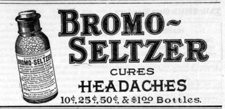
| | | | Today we take the Orange Route (click), this time to the west. For this, we make our way up to Lombard Street, again with two goals. To explain the first goal, we have to talk about headache relief (!) and also, how products disappear from the market without one's noticing. | | | | I remember growing up hearing ads for both Bromo-Seltzer and Alka-Seltzer, and in the past, have on occasion used the latter. It still exists, but to my surprise, Bromo-Seltzer is now gone. Both products use show biz to deliver aspirin and antacids to you. Bromo-Seltzer came in granules, Alka-Seltzer comes in tablets, but in each case, you dropped the granules, or two tablets, into water, and watched the show take place, as the exploding carbonation causes a sea of fizz in the glass, trying to convince the user that this spectacle is a Good Thing that will make the aspirin work better. | | | | Bromo-Seltzer came first. After one Isaac Emerson graduated as a chemist from the University of North Carolina, he moved to Baltimore in 1880, opened a small drug store, and developed his headache remedy, which he patented and started marketing in 1888. He undertook worldwide ad campaigns--this in 1908--in print and later on the radio which rocketed the sales of Bromo-Seltzer and produced great wealth for him. On the other hand, Alka-Seltzer was launched in 1931 in Indiana. | | | | Both products contained sodium bicarbonate—everyday baking soda--and citric acid, found in citrus fruits. These gave the fizz and the taste. The pain reliever Alka-Seltzer contains is aspirin, and Bromo-Seltzer had the same as what's in Anacin. So what went wrong with Bromo-Seltzer? It took its name from an active ingredient, a component in the original formula, sodium bromide. The sedative effect of bromides probably accounted for the popularity of Bromo-Seltzer as a remedy for hangovers, but bromides are a class of tranquilizers withdrawn from the US market in 1975 due to their toxicity. Early formulas also used acetanilide, now known as a poisonous substance. So the product is now gone. Take a look at this short (0:29) Jack Klugman commercial. It's particularly amusing that the point of the ad is that, though both products will take care of your problem, you have to wait for the Alka-Seltzer tablets to dissolve, while Bromo-Seltzer does its show-biz fizz straightaway. Is that really such a big deal? | | | | So what does all this have to do with our visit to Baltimore? On the Orange Route map, near where we catch the shuttle, find the Bromo-Seltzer Tower at Lombard and Eutaw, easily visible from here and also from the Camden Station we'll visit later. Emerson had this built in 1911 and the height of his fame. It's technically called the Emerson Tower, perhaps the Emerson Bromo-Seltzer Tower, but is usually shortened to just the name of the product. The
Bromo-Seltzer Tower (Photo by Acroterion) is 15 stories and 88 m (289 ft) high. It was the tallest building in Baltimore from it construction in 1911 until 1923. Originally, there was a matching factory building at its base, but that was demolished in 1969; the tower and building were inspired by the Palazzo Vecchio in Florence, whose tower is seen here (Photo by Georges Jansoone). The Bromo-Seltzer Tower has four Seth Thomas clock faces on the 15th floor (click) which spell out the name of the product, which is more prominent than the Roman numerals. The translucent white-glass dials, illuminated at night, are 7.3 m (24 ft) in diameter. The hands are 3.7 & 3.0 m (12 & 10 ft) long. The used to be driven by weights, but are now electrified. The tower was virtually abandoned in 2002, but officials began renovations in 2007 to transform the building into 33 artists' studios. The Tower is on the National Register of Historic Places.
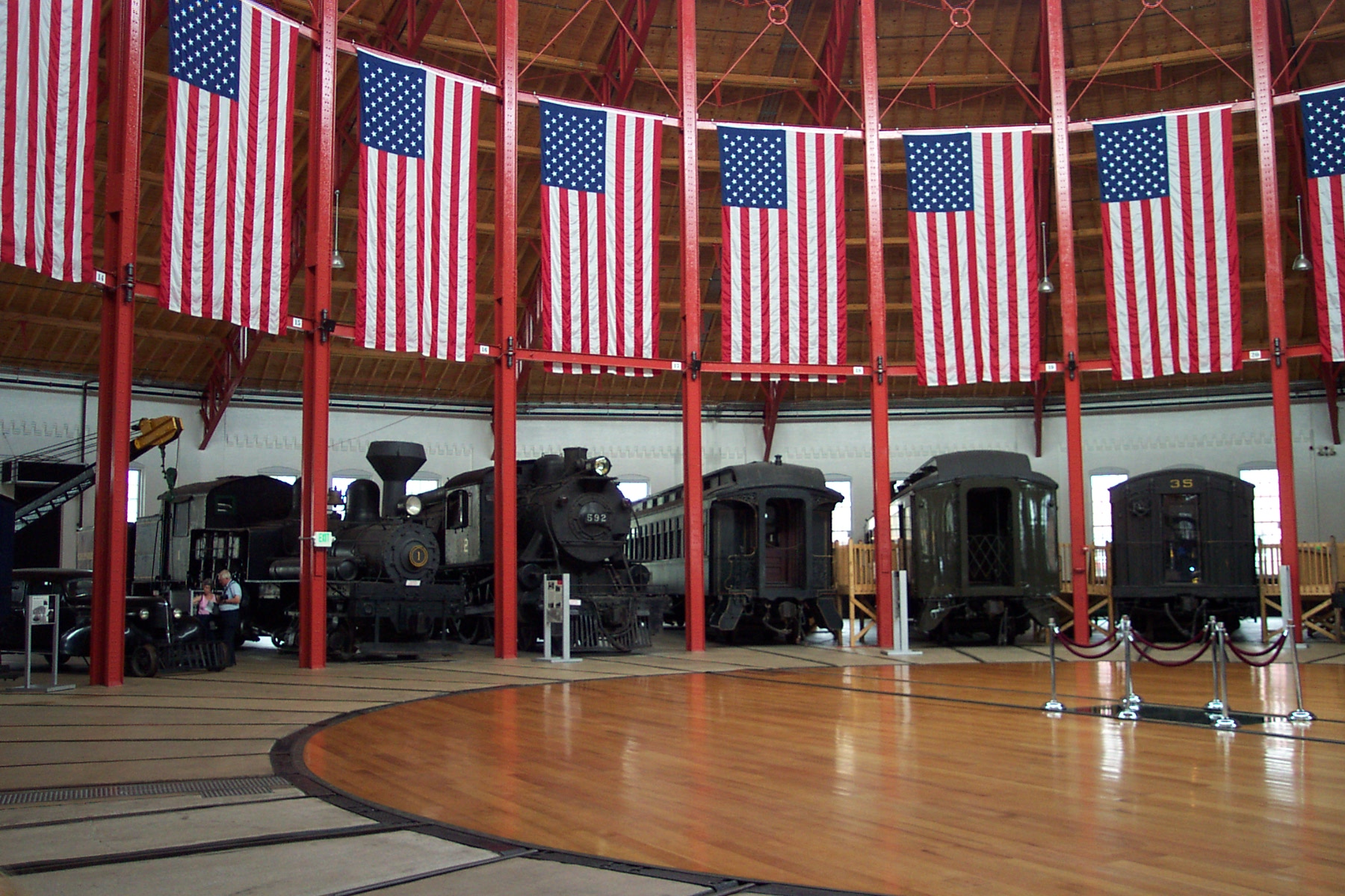
| | | | Our second goal on the Orange Route is the major stop of the day, right at the end of the line on Pratt Street, the B&O Railroad Museum. We need not go into great detail here, since we already discussed a great deal when talking about the other part of the museum, at the Ellicott City Station. I even bought a dual-entry ticket at that time covering that and also this main branch. We should say that this is a major US and worldwide rail museum, universally recognized as the birthplace of American railroading because of the inaugural horse-drawn B&O train that traveled on wooden tracks the 21 km (13 mi) from this spot, which at that time was the Mount Clare Station, to what is today Ellicott City on 22 May 1830, that being the first regular railroad passenger service in the US (2016/12). Use this plan of the grounds to get oriented, hitting the plus sign (+) at least four times:
http://www.borail.org/2014_MuseumMap.pdf
| | | | North is to the right, so Pratt Street with the stop on the Orange Route runs up-and-down to the right of the black area at the lower left. The original Station Building is at the museum entrance in the parking lot. It had been built the year before that trip, in 1829, replaced with the present brick structure in 1851. The roundhouse was attached to it in 1884 (exploded view on the right), and the Mount Clare workshops are steps away. The museum contains 200 locomotives and railroad cars, 40 of which are displayed in the roundhouse. There are exhibits indoors and out. We'll limit ourselves to the Station Building, Platform 2, and the Roundhouse.
https://c2.staticflickr.com/4/3759/11647479455_a72bccb6b2_b.jpg
http://www.borail.org/images/sce/Entrance.jpg
http://victorianweb.org/cv/rrmuseums/baltimore/1.jpg
| | | | The first picture is the Pratt Street façade of the Mount Clare Station (the 1851 one) with a bit of the attached roundhouse. The second is smaller, but more inclusive, with the entrance from the parking lot. The third shows the beauty of the architecture of the roundhouse from within the museum grounds. A bit of Platform 1 with its exhibits is to the right, but well be using Platform 2 on the left, of which that greenery is an extension. Inside the roundhouse (Photo by Wallstreethotrod) are exhibits of various eras. The location of the turntable that was used to move locomotives around is in the center. | | | | The Site While the reason for the location of this former station is pointed out in the museum, I think more has to be explained about why the station that was meant to serve Baltimore, was placed way out west in what had to be at best suburbs in 1829. In 2016/12, we talked a little about the involvement in the founding of the B&O of Charles Carroll of Carrollton, the last surviving signer of the Declaration of Independence. A distant cousin of his, the barrister Charles Carroll (I wonder how that family kept all its similarly-named members apart) had built in 1763 the Georgian Colonial home called Mount Clare (still in existence not far to the southwest of the museum), and he deeded this portion of his estate to the fledgling B&O Railroad Company for its station, in an area that also began taking the name Mount Clare.
| | | | I have recently come across two more reasons, other than the availability of land. The station was on Pratt Street, and we pointed out that the National Road went right along here to Ellicott City and beyond. It's been suggested that steam engines (steam promptly replaced horses on the B&O) weren't allowed downtown (as was also the case in Manhattan and Brooklyn, as we've pointed out in the past) and Mount Clare served as a transfer point for passengers to change from steam power to horse power, perhaps horsecars right down Pratt Street. The other matter was that the new company didn't feel itself in a strong enough financial position in the early years to build a big downtown station, and this was the cheaper option. It was in 1857 that the B&O finally opened Camden Station (see below) close to the Inner Harbor. | | | | Morse & the Telegraph We said we'd first visit the station building itself, and the reason for that involves Samuel FB Morse. Morse was an accomplished painter, a fact that eludes many today. In 1832, he learned of a French inventor's idea of an electric telegraph and then spent 12 years attempting to perfect a workable instrument. At the same time, he composed his Morse code, telegraphic dots and dashes that could represent letters and other symbols of the written language. He then convinced the US Congress to finance what would be the world's first commercial long-distance telegraph line, one that conveniently followed the tracks of the B&O between Washington and Baltimore. On 24 May 1844, he inaugurated the telegraph line in a demonstration witnessed by members of Congress. Morse sent a message from the US Capitol to Alfred Vail at the Mount Clare Station in Baltimore (an exhibit here commemorates that), famously remembered as a biblical quote, "What hath God wrought?" Vail received the message, then telegraphed it back to Morse in the Capitol a moment later, proving that the system worked. Just a decade after this first line opened, more than 32,000 km (20,000 mi) of telegraph cable crossed the US, shrinking the continent. | | | | We can now point back to the Mount Clare event being a precursor to the Wright Brothers sending a telegram to their father from Kitty Hawk in 1903 (2016/19). Then, once similar transmission networks were established in Europe, it was also a precursor to transatlantic telegraphic communications as of 1858 (see Trinity Bay, Newfoundland, 2013/13). It is also not too much to say that Mount Clare was a precursor to the later technologies of telephone, fax, and email. | | | | The second stop here we'll discuss is the museum's "First Mile" Train Ride, which leaves outside from Platform 2 and which is shown on the map as the "Mile One Express". The museum owns (up to the intersection with CSX) what is variously described as the first mile, or 1.5 miles (1.6 to 2.4 km) of track that the Pioneer took on wooden rails on 22 May 1830 the 13 mi (21 km) to Ellicott City. The route, and certainly this first "mile" is considered to be the most historic mile of rail track in the US. | | | | We'll see shortly how the outlying Mount Clare Station lost its passenger service (but became a maintenance area) when the Camden Station closer to downtown replaced it in 1857. But I had had a hard time picturing the change before the train ride. After a lot of online digging, I've found clear explanations.
http://trn.trains.com/~/media/images/railroad-reference/railroad-maps/trnm0314.png?mw=350
http://www.trainweb.org/oldmainline/lpb/lpbmap.jpg
| | | | These two maps show exactly the same thing, but what might be the clearer one is tiny, so review them both. On the small one, B&O Original Mile 0 is shown at the Mount Clare Station adjacent to the shops and that original route then runs down off the map to the southwest. Closer downtown, the later B&O Camden Station (which nowadays also has a dotted-line connection north to Penn Station) was set up to also run southwest, and join the original track south of the stream known as Gwynns Falls at Curtis Bay Junction, at which point it took over the original route. Note how these two routes joining resemble the capital letter Y. The otherwise disused upper-left arm of the Y, the "Mount Clare Branch" is the site of the museum's "First Mile" Train Ride. Now move to the larger map and confirm all this. Despite its more-confusing clutter, the rail tracks are easy to spot. Here, the junction isn't named, but the CSX Main Line is identified.
http://www.railfanguides.us/baltimore/map13/MtWInansYd2.jpg
http://www.eduborail.org/images/sce/first_13_miles.jpg
| | | | The first map (click) is a detail of the triangular Curtis Bay Junction, and the letter Y is clearer still. At its bottom, the Old Main Line is identified. I have to guess, but I'd say the train ride I took reached the area between 5 and 6, because I clearly saw the nearby CSX tracks to my left out the window. Finally, the second map shows the complete original V-shaped route to Ellicott City. Remembering that the current Curtis Bay Junction is just south of the Gwynns Falls stream, you can estimate the length of the "First Mile" trip. The rest of the right arm of the V is the original route, as used by the modern MARC commuter route to Washington, while the left arm of the V to Ellicott City has not had passenger service, only freight, for some time. As we explained in 2016/12, discussing the Old Main Line, Passenger service on the OML had become strictly local, and by 1928, only three passenger trains a day used this route. Service was ended totally after WWII. In 1959 the line was reduced to a single track . . . in order to increase the clearance of tall freight cars through tunnels. | | | | As for the train ride, at the scheduled time, we lined up on Platform 2 and entered a couple of mid-20C passenger cars. The round trip lasted about 20 minutes, and it was fun to ride this historic route, however short. That's the good news. The "less-good" news is that there were few, if any, adults by themselves on the train. There were, however, about four million little yapping kiddies, who apparently considered this just a ride on a choo-choo, which could have been accomplished anywhere. Frankly, observing their doting parents, it might have been their first choo-choo ride, too. | | | | Our third and final stop at the museum will be the roundhouse. Three exhibits interested me in particular, but we've already discussed two. In Ellicott City we talked about that first horse-drawn passenger car, The Pioneer, that did the trip on 25 May 1830 in one hour and five minutes. In 2016/12, do a Ctrl-F "Pioneer" to see the two fine pictures of the replica here at the museum. | | | | In 2015/1, in connection with our ride on the Capitol Limited, we pointed out that on 28 August 1830, just three months after The Pioneer first ran, the first American-built steam locomotive, Peter Cooper's Tom Thumb made its debut run on the same route, but took ten minutes longer than the horse-drawn Pioneer. He had built it specifically to convince B&O that steam traction would work on railroads better than horse traction. This was demonstrated in a famous race between a horse and locomotive right in Ellicott City. Even though the engine had some mechanical troubles and the horse won, the engine was adopted anyway and they were used as of 1832. This is the museum's replica of the Tom Thumb and this is a B&O publicity shot of it standing next to the B&O 1937 diesel locomotive used on the Capitol Limited of that time. | | | | Stagecoaches to Train Coaches The third and final thing in the roundhouse that impressed me enough to want to discuss considerably further involves the inertia of human perception. As an example, dial telephones went out of style in favor of pushbuttons, but people still talk of "dialing a number"; candlestick and wall phones had a hook to hang the receiver, but today people still talk about "hanging up" the phone, particularly unusual when applied to a mobile phone. Also remember that even the Wright brothers felt they needed a track, although a single one, for a plane to be able to take off, another example of an earlier technology influencing a new one. It's all inertia. It's our purpose here to show how stagecoaches pulled by horses along a road are absolutely the predecessor of train coaches pulled by locomotives along a rail track, both in fact and in terminology. One thing simply morphed into the other. Keep in mind we're discussing here the simplest of train rides, no dining cars, no sleepers, no doubledeckers. | | | | To start at the beginning, let's look at some authentic stagecoaches. A stagecoach is a type of covered wagon used to carry passengers inside, and sometimes goods, particularly mail. It has a powerful suspension, and is usually pulled by four horses. This is an original Concord stagecoach (Photo by Captain-tucker) in Wells Fargo livery on display at the Wells Fargo History Museum in San Diego. Click to inspect the face-to-face seating in the interior—let's call this "stagecoach seating"--and also the suspension to ease the rigors of the ride. Stagecoaches were widely used before railway transport, and their routes had periodic rest stops for passengers that were called stages (or stations), hence the English name for them, stagecoach. | | | | This is one of the few surviving genuine British mail coaches (Photo by DanieVDM), used between London and York (click). This online picture's caption dates the coach to c 1820, but look close—would you argue that date? VR is Victoria Regina, and Victoria became queen in 1837, so it seems that we need to move up the date a couple of decades.
| | | | | | I'd like to interrupt for a moment to point out that the English word here, referring to stages, is unique, although it can also be called a mail coach, as in German: Postkutsche; Dutch: postkoets. But by far, most languages, be then Latinate, Germanic, or Slavic, follow French: diligence. Examples are: Catalán: diligència; Spanish: diligencia; Italian: diligenza; Portuguese: diligência; Danish: diligence; Norwegian: diligense; Swedish: diligens; Polish: dyliżans; Russian: дилижанс / dilizhans. This has always confused me, since English—and French—uses "diligence" to mean "careful work". A little digging shows that, in Old French, and even back into Latin diligentia, a second meaning was "haste, speed". The original, and complete, French term was carrosse de diligence, literally "fast carriage", better phrased as "express coach". |
| | | | So what was it at the museum that set this riff off? It was this 1830s passenger coach (Photo by James G. Howes). Click to inspect its suspension on the lower carriage.
http://cdn3.historyextra.com/sites/default/files/imagecache/623px_wide/Train%202.jpg
http://railroad.lindahall.org/siteart/essays/passenger_rail_banner.jpg
| | | | I was glad to see it, since it corroborated what I'd seen in high school in a textbook, which was similar to the first picture above (1845), and the second picture is similar. This can be explained in two ways. The first railroad passenger cars were built by carriage makers, so they built what they were familiar with, stagecoaches, not with their own wheels, but mounted, singly or multiply, on four-wheeled railroad flatcars. That inertia would have been compounded by inertia on the part of the public, eager to continue riding in a familiar-looking vehicle.
http://gerald-massey.org.uk/Railway/images/Operational/LandMfirst.jpg
http://l7.alamy.com/zooms/98032277af4e4e37a7a99c08aba1f24e/first-class-wagon-built-in-1850-cite-du-train-museum-mulhouse-france-c93fd9.jpg
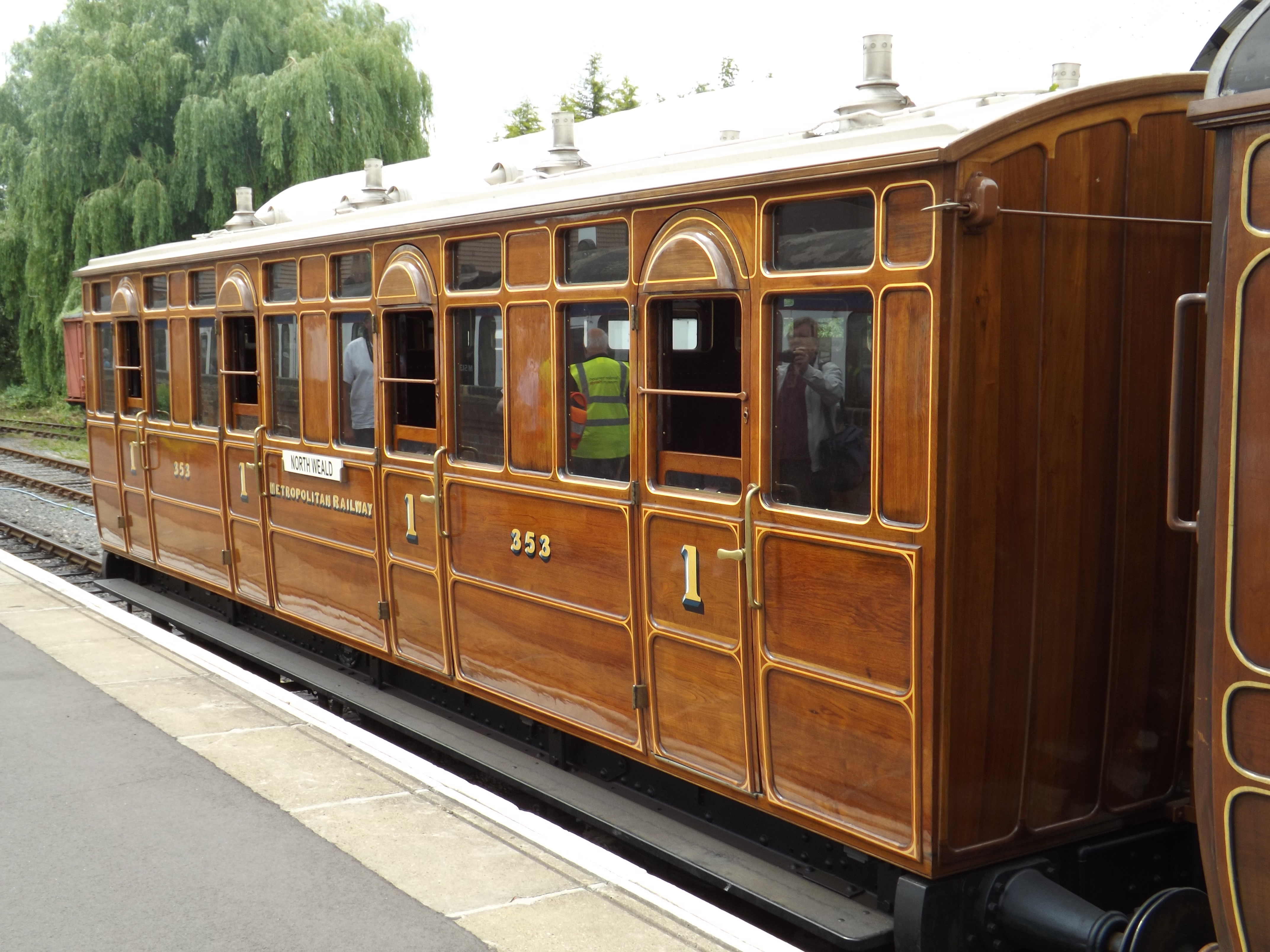
| | | | These two pictures show the same phenomenon, one in England, one in France. The first is a replica in an English rail museum, the second is a genuine 1850 first-class coach in the Cité du Train Museum, Mulhouse FR. Each one is a three-compartment car, clearly a single unit. And what do you notice about each livery? Each compartment is painted outside with rounded curves to look as though it were still actually a separate stagecoach—or diligence. This wouldn't have been done if it wasn't what people expected to see. | | | | Before we move on to later forms of train cars, I have to interject a drawing of something I found online that I never imagined would have existed. It's an 1884 drawing of a French mail coach as an example of early intermodal freight transport (Drawing by unknown 19C artist; Photo by Mattes). The caption reads: Maschine zum Übersetzen der Diligencen auf Eisenbahnwaggons, or "Machine for transferring stagecoaches to railcars", meaning flatcars in this early style. The drawing is in the Deutsches Museum Verkehrszentrum (Traffic Center) in Munich, and shows an apparent early borrowing into German of the French word, here with a German plural, Diligencen. It was a surprise in that, while pointing out how stagecoaches were the model for train coaches, there's an actual example of a stagecoach body being lowered on a train flatbed, just like containers are today. | | | | From the multiple stagecoach-seating compartments above, designs developed in three ways, which we can call 1A, 1B, and 2. As we saw, each compartment had its own exit door to the outside, with no interior connections. Early on, these became unpopular, because of security concerns and the lack of access to toilets. These, then had internal corridors added, but type 1A continued to maintain individual external doors in each compartment (Photo by Edgepedia). This style was particularly common in Britain for many years, as is noted in this Metropolitan Railway Jubilee carriage No 353 that was restored for the London Underground's 150th year celebrations.
http://pic.pimg.tw/duarte/49b3c982641fc.jpg
https://c1.staticflickr.com/5/4084/5025979477_ab887ae784_b.jpg
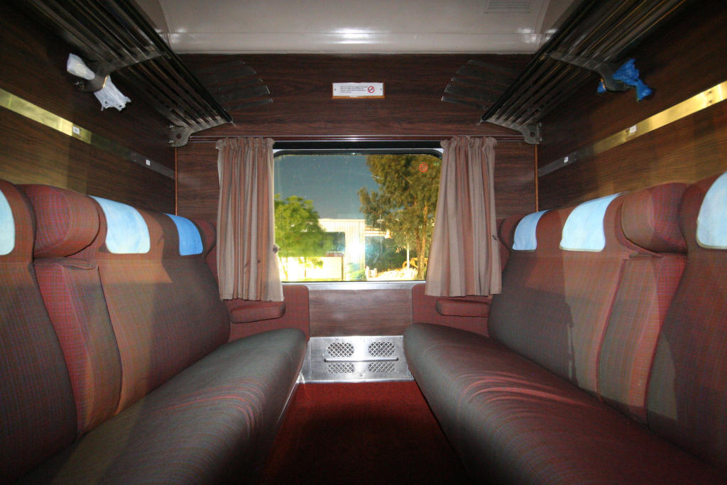
| | | | This style was also maintained in newer trains, as in the first picture above. They are called "slam-door trains" because of the characteristic noise made on departure of passengers all slamming their doors at once. The interior of a compartment on a slam-door train (second picture) maintains the greatest similarity to the interior of a stagecoach. | | | | But around the world, the individual doors disappeared, while the stage-coach seating within a compartment remained (type 1B), as in this Australian train (Photo by Marcus Wong), viewed toward the window through the door on the corridor.
http://www.vagonweb.cz/fotogalerie/foto/201203/IMGP8474.jpg
https://lwgsummerland.files.wordpress.com/2013/05/train-compartment.jpg
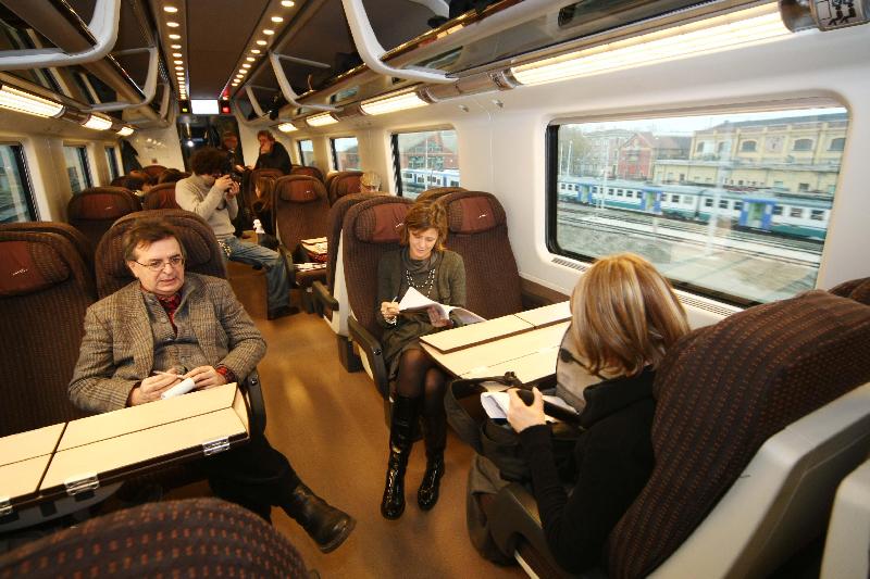
| | | | The first picture shows a Czech compartment, viewed sideways, showing both the corridor and window, and the second looks outward to the corridor. But at least in the US, the entire stagecoach-seating compartment idea was dropped early on, as early as 1834, in favor open-car seating of one style or another, which is our type 2. Perhaps it was wooden benches on the sides, as in The Pioneer, but later with rows of seats (Photo by Atomic Taco), as here on Amtrak's Cascades. All of these have only two sets of doors per coach, one set at either end. This concept has not been lost on Europe, since most modern high-speed trains in Europe now offer open-car seating, as we see in this second-class coach on Eurostar Italia (Photo by StuporesMundi). Type 2 was then the style that was transferred to airplane technology. But a strain of inertia remains from the stagecoach days. Train cars are still called coaches (carriages in Britain), and whether on a train or plane, it's still called Coach Class. | | | | Day 20: Baltimore 3 For our second and final full day in Baltimore, look again at the map for the Orange Route, although we won't use the shuttle immediately. The Sheraton is "A" at Charles and Conway Streets and not only do I have a view of Camden Station from my window, it's only a two-block walk there. | | | | Don’t be misled by the two light rail stops in orange. The former headhouse for Camden Station is on the south side of tiny Camden Street, now recycled for two museums (Sports/Geppi). As I look at this unusual location, I have to speculate the following. While the B&O found a location close to the Inner Harbor, my guess is that they would have loved to have the station one block north, on Pratt Street, just as Mount Clare Station was. Maybe the land was too expensive, this is only a guess, but they settled for being one block south. Might it have otherwise been called Pratt Station? I do not know, but it became Camden Station because of this small street. But it was a larger station than Mount Clare, and started operations in 1857. This is the splendid, restored headhouse of the former Camden Station (Photo by AndrewHorne) in 2008, as the first of the two museums opened. It's a three-story brick structure with three towers in the Italianate style. Click to inspect the architectural detail. The view is south from Camden Street, and the B&O Warehouse (see below) is visible behind it to the right. | | | | Camden Station served the B&O as its main passenger terminal in Baltimore until the 1980s, and is one of the longest continuously operated railroad terminals in the US. In 2015/1, in connection with the trip on the Capitol Limited, we said: In 1861, Lincoln traveled through Camden Station, and on the present Camden Line, to his inauguration in Washington. In 1863, Lincoln changed trains at Camden Station to go to Gettysburg to deliver his Address. In 1865 Camden Station was the first stop out of Washington of Lincoln's funeral train on the way to Springfield, Illinois. We can now add that, during the four years of the Civil War, the B&O's line from here to Washington was the sole rail link connecting the Federal capitol with the North. Also, trainloads of wounded soldiers and Confederate POWs came through the station following the Battle of Antietam (2016/13), which lies just 121 km (75 mi) west of Baltimore. | | | | On the Orange Route map, look just south of the headhouse. The first area where tracks used to be is now just a parking lot, but as of Conway Street, there is a remnant of rail service. Both MARC commuter rail and local light rail use the outdoor platforms here. Below is a map of the MARC Camden Line to Washington (ex-B&O) as well as the MARC and Amtrak Penn Line to Washington out of Penn Station (ex-PRR).
http://2.bp.blogspot.com/-KMCwVeHIpTQ/UK232ZKdDJI/AAAAAAAAcsk/syyr-gPKs6g/s1600/MARC-SystemMap-Nov2012-DC-Baltimore-corridor.JPG
| | | | This is MARC's Camden Station (Photo by Jfruh), shared with light rail, three island platforms and six tracks. Click to inspect the MARC coach on a stub track. But behind it, notice the huge brick east façade of the former B&O Warehouse. This is the view from my hotel window some two blocks away. B&O built the warehouse from 1899-1905. Its eight stories had floor space to hold 1,000 carloads of freight at a time. It was used through the 1960s but mostly vacant after that, because of the use of trucks and single-floor warehouse in industrial parks elsewhere. | | | | The Orange Route map doesn't show the warehouse, but we have to walk back up to Camden Street to go around the warehouse to find the large area that used to be the rail yards for the station. This has been the location since 1992 of Oriole Park at Camden Yards, usually shortened to just Oriole Park or to Camden Yards. The entryway is at Eutaw Street, where there's a statue of Baltimorean George Herman "Babe" Ruth in a small park. Then follows a pedestrianized section of Eutaw serving as a midway between the former warehouse and the baseball stadium (Photo by James G. Howes). We're looking here at the west façade of the former warehouse. The whole building was converted to team offices, team spaces, and a private club for the Baltimore Orioles. Click to see the remaining faint white letter designations of the warehouses in the brickwork. From the walkway, you could peer into the stadium, and I found it a rather good recycling of all the facilities. The only oddity is that, with the downgrading of the station and popularity of the stadium, people have started calling the station Camden Yards, an example of the tail wagging the dog—the station being named after its former yard. | | | | We now walk up Eutaw and get a perfect view of the Bromo-Seltzer tower from this direction. At Pratt we take the Orange Route again, this time eastbound. It's very pleasant to coast right past the Inner Harbor park area and the USS Constellation, where we had also been docked. These shuttles are the best. We cross over the Jones Falls stream to the Jonestown neighborhood, a former settlement on Jones Falls, where we can change to the Green Route. We'll be back in this area later going home.
http://www.charmcitycirculator.com/sites/default/files/imagecache/full_960px/CCC_RouteMap_UPDATED_wExtension_062716_Green.png
| | | | We now get on the Green Route with two destinations in mind. We enter Fells Point and the shuttle goes up Broadway, divided in the center, to the north end of the route, where we get to know more about the 19C Baltimore philanthropist Johns Hopkins. Curiously, this, too, is rail related, since his fortune was generated primarily from the B&O Railroad. I'd always wondered about his unusual first name, which turns out to be the surname of his great-grandmother, Margaret Johns, who married Gerard Hopkins. | | | | His 1870 will set aside funds for his philanthropy, which were mostly in B&O stock. Most notably, after his death in 1873 were founded (see shuttle map) Johns Hopkins University in 1876, the Johns Hopkins Hospital (with several related medical institutions) in 1889 and the Johns Hopkins Press in 1878,, the longest continuously operating academic press in the US. His instructions for the hospital were explicit, that it was to assist the poor of "all races", with wealthier patients subsidizing the indigent, and that the hospital should be part of the university. His bequest was the largest philanthropic gift in the US at the time, and led the university to revolutionize higher education by integrating teaching and research, making it the first research university in the US. The concept of a graduate school was adopted from Heidelberg University in Germany. The hospital, with its related medical schools, is considered to be among the world's greatest.
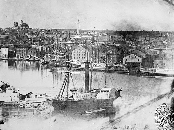
https://baltimore1797.files.wordpress.com/2015/02/baltimore-1752.jpg
| | | | We view the hospital area from the shuttle, and return south on Broadway, headed for the waterfront. It's at this time we can summarize the area best. See if you can recognize what the above drawing shows. | | | | This is Baltimore Town in 1752. We're looking at the Inner Harbor, the area that used to be called the Basin. Where the one-masted ship is is where the Constellation is, and where we were docked. Where the two-masted ship is is where the aquarium is today. Pratt Street today goes left-right behind the first houses, and Light Street goes along the left shore. But the best part of this idyllic scene is the fact that on the right, we can see the Jones Falls stream looking as a stream should as it enters the harbor. | | | | When this drawing was made, Baltimore Town was over two decades old, since it had been founded and laid out in 1729. Look at the far bank of Jones Falls. Now refer back to the Green Route map where we changed shuttles. You see Jonestown today, which had been founded and laid out in 1732 by David Jones on the east bank of the Jones Falls stream. Further to the right, English shipbuilder William Fell, who had established his shipbuilding company on the waterfront back in 1726, founded Fells Point around it in 1763, as a shipbuilding and commercial center, and his son Edward Fell laid out streets and began selling plots for homes.
In 1773 Baltimore Town merged with Jonestown and Fells Point, and n 1796-7 was incorporated as the City of Baltimore. So it was really quite early that these three settlements merged.
| | | | Fells Point has a maritime past and still has the air of a seafaring town. The Fells Point shipyards produced some of the first vessels for the US Navy, including the USS Constellation in 1797. But they're best known for producing what are commonly called "Baltimore clippers"; some like to refer to them more accurately as "Baltimore schooners". They were fast sailing ships that also included brigantines. Because of this, the Fells Point shipyard was a prime target for the British in 1814. Over 600 ships were built here through the Civil War, after which the shipyard could no longer handle the larger ships then coming into use, particularly the steam-powered ones. | | | | Fell's Point includes a diversity of historic architecture. Flemish bond brick is used in some of the earliest homes, while row housing is prominent in 19C and early 20C houses. But then Fells Point declined, and became an unsavory neighborhood. Most of the 18C-19C homes and storefronts became one of the "three B's": boarding houses, brothels, or bars. It became a neglected, run-down neighborhood of warehouses and other buildings along cobblestone streets. Most of these buildings were completely dilapidated along the deserted Market Square, now called Broadway Square. The neighborhood had just about hit bottom. | | | | Since the 1970s, a steadily increasing number of middle to upper middle income residents has moved into the area, restoring and preserving historic homes and businesses. Most of the activity was centered on Thames Street along the long-neglected waterfront, as the area began to slowly prosper as a dining and entertainment district. Thus Fell’s point became the target for both Baltimore’s young set and historic preservationists. In 1969, Fells Point was designated Maryland's first National Historic District.
https://imageserver-bisnow1.netdna-ssl.com/7kOrfxNXXISlZL3RPj279Ihy5i0=/0x0/publisher/77592_1440088557_broadwaymarketnorth-large.jpg
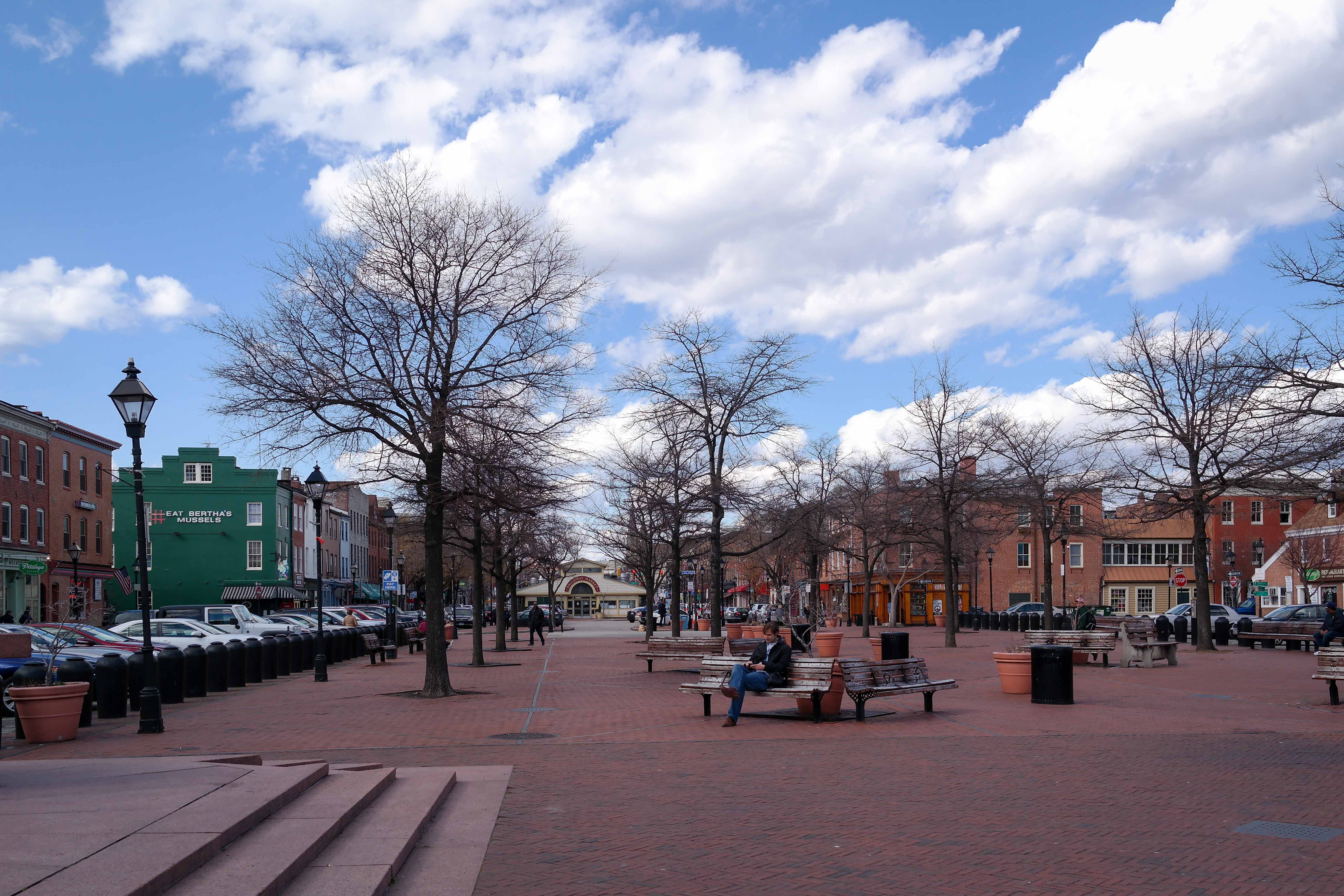
| | | | Since the shuttle is about to turn off Broadway (see map; that will be our route home via the Orange Route again), we'll get off at Fleet Street and the Broadway Market, which fills the center of the street for two blocks to the south, the third block being Broadway Square, now a public park. Broadway runs down both sides of the market and park. The Broadway Market is considered the gateway to historic Fells Point. While the market dates to 1784, the new brick façade was designed to recreate a public gateway. It won the Award for Design Excellence of the Baltimore Chapter of the American Institute of Architects. | | | | We'll find that this final stop in Baltimore will turn out to be the most enchanting of locations, for history in general, for renovated and restored historic buildings, for water views, for people watching in the park, and for it being a beautiful spring day during Memorial Day Weekend.
http://files.meetup.com/2026551/FellsPoint_BoaF_Parking.png
| | | | I was at first bothered that this, the best map I could find, is a parking map. But actually, it just goes to show how popular the neighborhood has become as an entertainment district. And of course, we don't have a car to park, since we were clever enough to arrive by public transportation. I want to try to recreate the pleasant atmosphere of this visit using online pictures as we walk down to, and around, the waterfront. Follow us on the map as we walk down Broadway from Fleet Street to the west of the Market. | | | | This is the SW corner of Broadway and Aliceanna (Photo by Smash the Iron Cage), looking down toward Lancaster. You must imaging more leaves on the trees, since it's May. We then come to the interestingly named side street called Shakespeare Street (Photo by Smash the Iron Cage), which shows the typical brick construction in the neighborhood. The map will show we're seeing this from Broadway Square, which is where we'll end up. From here, it's just a few steps to the angular corner of the famous Thames Street (Photo by kke227 Somerville), looking southwest, still from Broadway Square.
| | | | You'll note on the map that Broadway continues south of Broadway Square onto Broadway Pier (Photo by Iracaz at English Wikipedia) with nice views of the waterfront area, including the large City Recreation Pier on the left (see map). The Belgian block paving (click) and period streetlights add to the atmosphere. Continuing east along Thames Street opposite the City Recreation Pier we find charming storefronts (Photo by Preservation Maryland) and more historic façades (Photo by Baltimost) along the Belgian blocks of Thames Street. We then go a bit south on Ann Street for this view back over the water (Photo by Preservation Maryland).
| | | | Let's walk back to Broadway Square (Photo by Smash the Iron Cage), looking inland from the water to the south end of the Broadway Market (click). But you MUST picture this scene with the spring greenery of late May to get the full current atmosphere. Also, note the right-hand end of those two benches in the foreground.
http://l7.alamy.com/zooms/29a11f23c33c41c587f40167caeaeb49/the-pretzel-twist-broadway-square-fells-point-baltimore-md-g211m0.jpg
https://planning-org-uploaded-media.s3.amazonaws.com/legacy_resources/greatplaces/neighborhoods/2012/img/fellspoint01.jpg
| | | | Immediately to the right of those benches was the lemonade stand in the first picture. I've often said I don't snack during a travel day, but this was different. It was mid-afternoon, but the travel day was over, and it was time to relax. A glass of fresh lemonade would go so well with a hot dog. The second picture shows those same benches, and I sat down where the man on the left was sitting (you can find ANY pictures on the internet). A Punch and Judy show was taking place nearby, I had a view south to the water under the shade of my tree, and as these last two pictures finally show, the spring weather was perfect, to people watch and enjoy my hot dog and refreshing glass of fresh lemonade. | | | | Day 21: Train to New York Memorial Day itself was a leisurely travel day back home. After a relaxed breakfast in the Club Lounge with its views came checkout, and the Purple Route shuttle to Baltimore Penn, this time with my wheeled bag. Though this is the Northeast Corridor, with frequent service, I'd booked an afternoon train on the Northeast Regional, so I spent sometime writing on my laptop in the waiting area.
| | | | This is the same map of the Northeast Corridor (Map by SPUI) we used at the beginning, showing the entire route from Washington to Boston. Sections owned by Amtrak are in red; sections with local commuter service are in blue. Starting in Baltimore, we passed by train exactly the same locations we had been earlier on the road, first Havre de Grace, then crossing the Susquehanna, Perryville, which has MARC service out of Maryland. I had chosen this mid-afternoon train because I knew it stopped in Newark, Delaware (more below), where I'd never been, and just peered at from the train. Newark DE has commuter service by SEPTA out of Philadelphia, but Amtrak stops here only on weekends and holidays (today), once each way. We then stopped in Wilmington DE, where this whole trip started with the car rental at the station to go to Chesapeake City. After other stops, we stopped at Newark, New Jersey, which has very frequent service and is familiar to me, and ended up home at New York Penn. | | | | Newark NJ vs Newark DE On this trip we discussed Beaufort SC (BYU.fert) versus Beaufort NC (BO.fert). That isn't just a phenomenon of the South, because in the North, we have Newark NJ versus Newark DE. We'll explain the difference as soon as we review the background. For me, it all started as a child, when I remember reading that train conductors were always careful on this route to pronounce the names of the two cities correctly, as they weren't the same. As with Beaufort, I have no explanation, and suspect no one has a valid one here, either, at least one that isn't an old wives' tale. But here's the background.
| | | | Newark NJ was founded by Connecticut Puritans in 1666. Newark DE was founded by Scots-Irish and Welsh settlers in 1694. The NJ city is believed to have been named for Newark-on-Trent in Nottinghamshire, and that on the basis that the English minister who was involved in its founding may have ministered there. I find no information anywhere about where the DE city got its name. We can only assume it was named after either the Nottinghamshire city or, secondarily, after the New Jersey city. | | | | In any case, the Nottinghamshire city's name is based on Old English niwe "new"—no surprise—and weorc. Sources say this word means "fortification" or "building". Nonsense. Why complicate an explanation without showing the path of meaning? The word clearly looks like "work", and that's just what it means, although we usually use it in the plural, but construed as a singular ("an ironworks", or "a waterworks") to describe a building. (In German it's Werk, [VERK], and on one or two occasions, Beverly and I picked up a VW we'd bought before leaving home at the Volkswagenwerk in Wolfsburg.) It turns out that there had been an "old work" castle dating from 1073, which was replaced by a "new work" in the 12C. This "new work" was eventually altered slightly to give its name to Newark[-on-Trent], later adopted by Newark NJ, and probably by Newark DE. | | | | But with different pronunciations. The original name, and also the NJ name, is NU.erk. The DE name, however, is NU.ark. You may not hear the subtle difference, so let's put it this way: | | | | | | NEWARK NJ: NU.erk, rhymes with "lurk, dirk, perk"
NEWARK DE: NU.ark, rhymes with "lark, dark, park"
|
| | | | There is a theory that that same minister, in founding the NJ city, told his followers that the new city in DE should be named "New Ark" for "New Ark [of the Covenant]". While there is little to nothing supporting this theory, this bit of ephemera seems to me like a very convenient bit of folk etymology, which I, personally, am inclined to heartily reject. Of course understanding the origin of the name doesn't explain the two different pronunciations, which probably occurred willy-nilly, and so what's true for Beaufort is equally true for Newark. | | | | Freebies It's only been in recent years that I've learned to play the freebie game of using points of one sort or another. Being without these freebies would not have been a deal-breaker, but it's always fun to get something for nothing. Free on this trip were: | | | | | | 1) Club Acela Lounge in New York on a pass I had from earlier;
2) three train trips, in Business Class; on a transfer of Starwood hotels' Starpoints to Amtrak (having lacked sufficient Amtrak points): New York-Wilmington; Washington-Charleston on the Palmetto; Baltimore-New York;
3) one night at Starwood's Le Méridien Rosslyn on Starpoints;
4) two nights at Starwood's Sheraton Inner Harbor, Baltimore, Club Floor, on Starpoints;
5) one day's car rental at Enterprise Charleston on Enterprise points to get to Fort Moultrie and the Plantation District.
|
| | | |
| |
|
|
|

