|
Reflections 2017
Series 1
January 5
East Coast XI: St Michaels – War of 1812, the Chesapeake Campaign
| | Day 17: St Michaels We woke up the next morning already docked in St Michaels. It would be hard to picture a more convenient place to be, since we were docked right at the Chesapeake Bay Maritime Museum, the main feature of the town.
http://www.thebayguide.com/old_site/images/midbay.gif
http://www.samspizzastmichaels.com/tinc?key=y7T4nZHn
| | | | For orientation, we repeat above the Eastern Shore map (click), reminding of the misprint, since the museum is really right in town. But we also have the more detailed Miles River map, showing more of the area around St Michaels and the width of the estuary. The museum is located on Navy Point, which can be seen projecting on the north side of the harbor in both maps. It was once a site of seafood packing houses, a cannery, docks, and work boats. Today the Museum has the world's largest collection of Chesapeake Bay boats, and still has a working boatyard where they are maintained.
https://media-cdn.tripadvisor.com/media/photo-s/07/c1/2f/f9/chesapeake-bay-maritime.jpg
| | | | This is a great aerial view of Navy Point with the Museum, with St Michaels in the background and its harbor to the left. We'll have a plan of the grounds later for more precise location of sights, but for now, just note how convenient it is to have the American Star docked at the furthest end of that lawn on the lower right, just steps off the gangway to everything. Stepping off the ship, I was immediately drawn to the most special of the sights at the Museum, one that I remembered from the past, that blue-roofed roundish building just steps away, but just as I went to actually see the best thing first, I want to save discussing the best thing for last. | | | | Before continuing the Museum visit, I had an errand in town. I'd looked up a drugstore online because of a head cold, and one was very close. You see two routes into town—that's Mill Street on the right, but I took Cherry Street on the left.
http://tidewatertimes.com/wp/wp-content/uploads/2014/10/STM.jpg
http://c8.alamy.com/comp/BM4NB6/talbot-street-shops-and-restaurants-st-michaels-st-michaels-maryland-BM4NB6.jpg
| | | | The town is small, just about 1,000 people. Find Navy Point on this map, but don't think I had to tread water on Cherry Street. Part of it today is closed to traffic, but from Burns Street, a comfortable pedestrian boardwalk into town goes through, which appears in brown on the last photo, and even crosses that tiny stream on an attractive footbridge. The main street, Talbot Street (2nd photo), and the drugstore were just steps away in the late 18C-early 19C town.
http://cbmm.org/development/wp-content/uploads/2015/01/CBMM_CampusMap_Large.jpg
| | | | This map of the museum shows it all, but is oriented outward, so picture the American Star docked at the far end, labeled Navy Point. Coming back down Cherry Street toward the Museum entrance at the lower right, we come across an interesting inclusion. There are three administration buildings in green on the way (click). They are the Higgins, Dodson, and Eagle Houses, historic 19C St. Michaels homes now recycled for administrative use. The Dodson House, 1851-1861, and the Eagle House, 1877-1891 (Both photos by Fletcher6), are pleasant Victorian additions to the landscape.
http://4.bp.blogspot.com/-mA8U8Ur5-Lk/UgVYUObwSsI/AAAAAAAAKLg/ycEEaB8aO0M/s1600/DSC_0070.JPG
| | | | While I had plenty of time to visit the entire museum, the color coding on the map is accurate—the locations in red are the more interesting, and worth describing. They lend themselves to three categories. The first is number 8, the Waterman's Wharf and, as the map shows, it's a hands-on place—the fancy word is "interactive"--right on the "living waterfront" and watermen's boats docked nearby are part of its "Floating Fleet". This picture (click) shows it's a recreated crabber's shanty on a pier, where, as they say, you can "practice seafood harvesting by hauling an eel or crab pot out of the waters of Fog Cove". I didn't see any eel or crab pots, but a woman was demonstrating soft-shell crabs on a display table. Once they molt their old shell ("exoskeleton") they are still soft, while the new one is in the process of growing. For harvesting, they are removed from the water as soon as they molt to prevent hardening of the new shell, making most of the crab edible (for those so inclined). She was showing on the table several soft-shell crabs and several shed shells.
http://bloximages.chicago2.vip.townnews.com/myeasternshoremd.com/content/tncms/assets/v3/editorial/9/65/96593329-d53d-5657-8ba8-e252f3b24cb7/524c1155e0658.image.jpg
http://www.rodneysoysterdepot.com/images/tao/toning_oyster.jpg
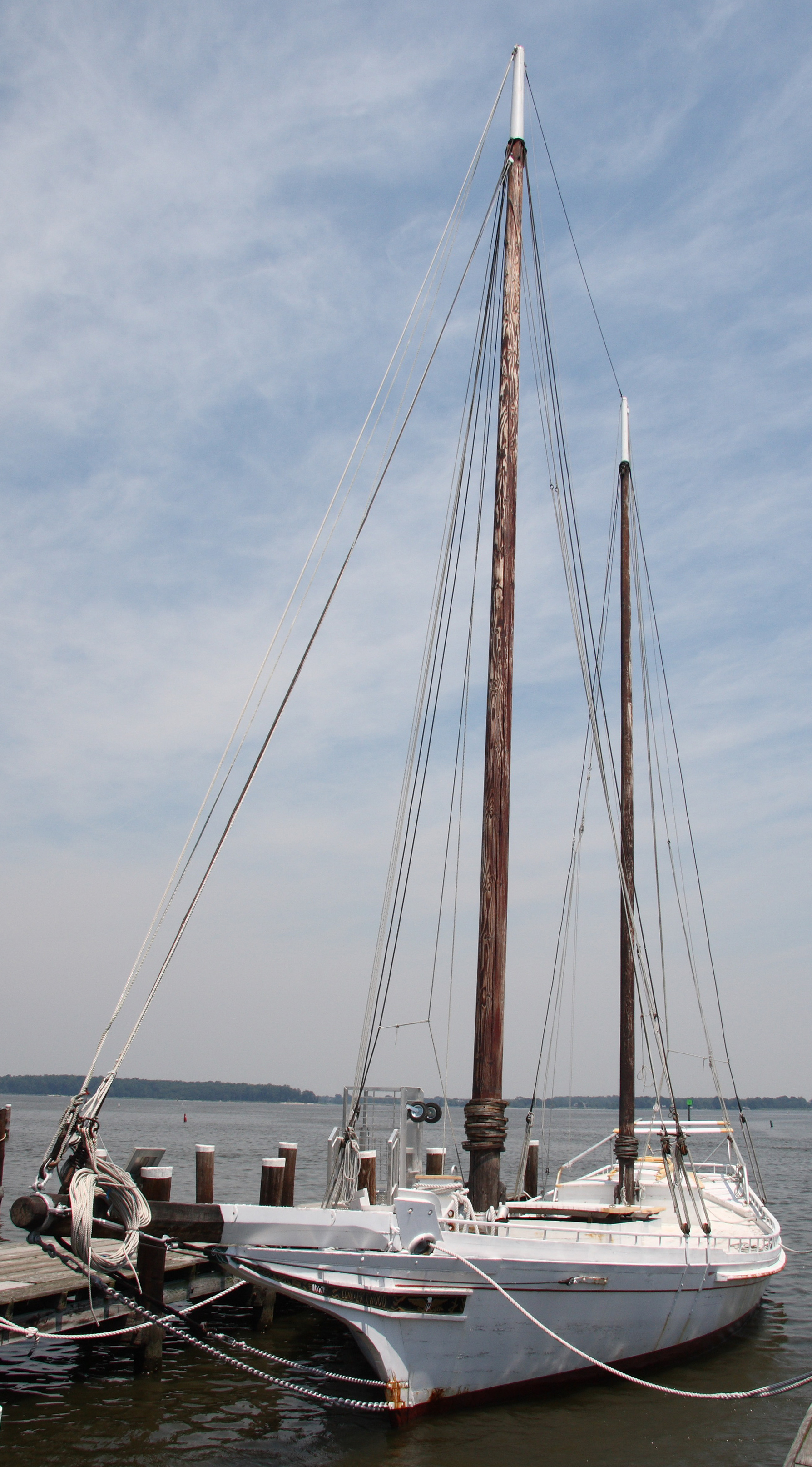
| | | | You could also try using traditional oyster tongs—or as they say, you can tong for oysters—to scrape up oysters from the bay bottom right at the dock, although it would also more likely be done from a boat. The first picture shows how huge they are, like chopsticks for a giant, while the second picture shows how they really are scissor-like tongs ending with a pair of opposed rakes to scrape the oyster beds. | | | | The second item of interest were two kinds of historic Chesapeake Bay sailboats, both used for oystering. Number 1 on the map is the location of the Edna E Lockwood (Photo by Acroterion), a restored Chesapeake Bay bugeye and the last working oyster boat of her kind, built in 1889. She's been declared a National Historic Landmark, is maintained in sailing condition, and sails out on the Bay for special events. Of course, I had to go searching for the two names. It turns out that the identity of her namesake, Edna E Lockwood, remains unknown. Now look again at the picture, where that hawser, or heavy cable, comes through that very prominent hawsehole on the bow. It's believed these hawseholes are the origin of the name "bugeye". However, I didn't see the Lockwood in this condition. As mentioned, this is a working boatyard, and she was demasted and in drydock being refurbished.
| | | | The other sailboat is demonstrated within the building of number 9, where, though indoors, you can scramble all over it to get the feeling of it. As oyster harvests dropped, the bugeye was superseded by the skipjack, which Michener mentions repeatedly. Skipjacks remain in service due to MD laws restricting the use of powerboats for oystering. This is a working skipjack. | | | | The third and final item of particular interest was that very first one we visited, right near where our ship was docked, but whose description we left for now. It's number 2 on the map, the Hooper Strait Lighthouse . If you click on it, you'll see even its sketch shows that it's surprisingly short, surprisingly squat, and surprisingly hexagonal. But that's not the end of the surprises. As Harold had adverted us on the ship, it's a screw-pile lighthouse, which essentially says it's screwed into the ground! Or anyway, at least its individual piles are. This screamed for more research, so let's look around first, and get back to this structure in a moment. | | | | This picture, published in a maritime book in 1910, shows just what a screw-pile lighthouse is all about. It's not a tall, masonry structure as so many lighthouses are, but a wood-frame hexagonal (or octagonal) cottage, usually 1 ½ stories high, standing spider-like on piles. Above are dormers and a cupola light room. As the picture inset shows, each leg is a pile with a screw at the end, meant to bore into mud for a surer footing. Most had iron piles, though some had wooden ones with metal screw sleeves. There was usually a central pile that was set first, and then the six (or eight) piles on the perimeter were screwed in around it. They could stand in water, or on a bit of land, or on a spot that could be either, depending on the tides. | | | | I could not imagine how you'd screw something of this size into the ground, even if it is mud, and I needed some extra physics vocabulary to help me understand it. Just as a windlass is a winding or rotating machine with a horizontal axis to lift weights vertically, a capstan (Photo by Leonard G) is a winding or rotating machine with a vertical axis to pull weights horizontally, such as an anchor on a chain. In this illustration, poles would be inserted in the square holes to be operated by deck hands. The screwpiles were turned by 4-ft (1.2 m) capstans worked by 30 men. (!!) I still have a bit of trouble picturing this, so I have to speculate again. If a mayonnaise jar lid is stuck and needs twisting, you can put a cloth over the top to help. I have to picture placing a capstan that is fitted over the upper end of a pile in a similar manner. Still, split-pile lighthouses were relatively inexpensive, easy to construct, and quick to build. | | | | They were invented in England, and the first were built at the mouth of the Thames and north of Blackpool on the Irish Sea in 1838-1841. One remains in France, dating from 1859. The first in the US was built in Delaware Bay, and perhaps up to 100 screw-pile lighthouses were built there, plus in Chesapeake Bay, and in the Albemarle-Pamlico Sounds in NC; also some on the Gulf of Mexico coast, at least two in Long Island Sound and one in Lake Erie. Few survive, since many were replaced over time with other structures. | | | | | | In 2015/4, when in Galveston and the Bolivar Peninsula, we discussed stilt houses there and also all along the Gulf Coast, buildings raised up on stilts to help save them in case of storm floods. A raised screw-pile lighthouse is reminiscent of those structures, and that style presumably helped many of them during hurricanes and other storms on the East and Gulf Coasts. But in the colder areas, being raised didn't necessarily help against ice floes, which were a major nemesis of screw-pile lighthouses and destroyed a fair share. |
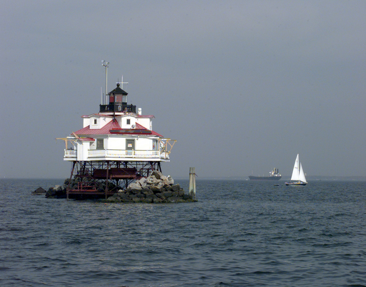
| | | | Still holding off on our lighthouse, take another look at our Eastern Shore map. On the left, you see a bit of Annapolis which ends in Thomas Point (not named). But on a shoal (sandbank) out in the channel there is clearly labeled the Thomas Point Shoal Light (click). We did not get to see this the following morning, since we left St Michaels too early, so we'll all have to enjoy it from the picture. It's the only screw-pile lighthouse on Chesapeake Bay still located on its original site, was built in 1875, and it's claimed to be the most recognized lighthouse in MD. It's also equipped with a foghorn. It seems to be a magnificent sight, especially that it's still in situ.
http://www.kellyworld.com/Photos/Delmarva/DelmarvaBig.JPG
https://www.tide-forecast.com/tidelocationmaps/Hooper-Strait-Light-Chesapeake-Bay-Maryland.10.gif
| | | | We used this Upper Delmarva Map (click) in the last posting, and will need it again shortly. For now, look south of Cambridge to the area of Hooper and Bloodsworth Islands to find Hooper Strait, further detailed on the second map. This is where the Maritime Museum's Hooper Strait Light (Photo by Fletcher6) was originally located. It was first built in 1867, is one example of a lighthouse that was torn loose by ice and lost, but was then rebuilt in 1879. It remained in service until 1954. I so enjoyed visiting the Hooper Strait Light that I'm including two more pictures:
http://lighthousegetaway.com/lights/MD/hooper1.jpg
http://www.lighthouseinn-ct.com/lighthouse-pictures/people-touring-the-hooper-strait-lighthouse.jpg
| | | | But I'm disturbed by how the structure is displayed. Compare these three pictures of it with the above book sketch and the Thomas Point Shoal Light. Do you see a major difference? | | | | It's of course that ridiculous staircase that stands out like a sore thumb. I climbed it to tour the building, and at the top saw a small notation that said the lighthouse keeper would access the building by boat dropped down from that railing, and then enter over the railing. I think I'm pretty sharp, but my first thought was why the bozos didn't tie up to the staircase and climb up the steps instead of going to all that trouble? And I'm sure that many other people wondered the same thing. | | | | It eventually becomes obvious that the Museum defaced the structure by adding such a visible staircase for visitors and then giving the impression that it was original to the structure by painting and styling it to match, which I'm sure most people thought. Those two earlier pictures show that no staircase exists on this style of structure, but that boats are hanging from the side for access. And the hanging boat is particularly clear for the following period picture of the Hooper Strait Lighthouse in 1916, still in situ:
http://www.lighthousefriends.com/hooperstrait_1916.jpg
| | | | The cultural essence of a lighthouse is its lonely inaccessibility, the feeling that "you can't get there from here", and the overenthusiastic defacing of this one with a necessary, but non-discrete, unexplained staircase is poor curating. I see two ways it can be improved. The "quick and dirty" way is to paint the staircase to shows it's different, say battleship gray, and adding a clear sign at its bottom explaining that it isn't original to the building and how boat access was the norm, rather than having that explanation upstairs. Better still—but it'll never happen—would be to move this staircase, or build another, adjacent as a freestanding structure, painted to contrast, with a short catwalk over to the lighthouse deck and again, a full explanation. That would both give visitors access and still maintain the isolated integrity of the structure. In contrast, we'll discuss later a similar light now relocated to Baltimore's Inner Harbor, where the added-on visitor-access staircase is much more discreet. | | | | War of 1812 We need once again to refer back to the all-but forgotten war (except in Canada), the War of 1812. We talked about it most recently when in the South in 2015/9, discussing Andrew Jackson and the Battle of New Orleans in Chalmette, which took place on 8 January 1815. It was the last battle of the war, which actually occurred after the signing of the peace treaty. | | | | We'd already talked about it extensively in the North in 2013/2 when in Ottawa, pointing out that one of the reasons that favored Ottawa becoming the capital was its relative distance from the dangerous US border. And the Rideau Canal (2014/16) was built so that Canadian shipping after the war between Lake Ontario and the Lower St Lawrence could avoid the part of the Upper St Lawrence along the US border by instead taking the Rideau, then the Ottawa River. We also mentioned the Valiants Memorial near Parliament with statues of Canadian heroes, including several from the War of 1812 that were involved in fighting the US. This all to underline the importance of the war in Canada. | | | | We even discussed it a bit between those two points, with the burning of Washington in 2013/14, but we're now in the Chesapeake and that will now become part of the focus of the current discussion. This time it will be an attempt to tie it all together, with emphasis on the Napoleonic background and the reasons for the war. It's most easily characterized as an Anglo-American war, more precisely as a war between the US on one side, and, on the other, (1) Britain, (2) its remaining North American colonies (BNA), and (3) its Native American allies. As to those colonies, let's clarify that. Part of British North America (BNA) that was established after the First Landing at Cape Henry had broken away to become the US, leaving a number of colonies to the north then still classified as BNA, since they didn't become confederated as Canada until 1867. | | | | The war is remembered nary a whit in Britain, Europe, and internationally. That leaves the US and Canada. If remembered in the US at all, it's in the odd folk hero. Sort of. Or were Dolley Madison, Andrew Jackson, and Francis Scott Key part of the Revolutionary War? No? They fit in here? Really? It's hard to explain US amnesia about this war. Maybe it's because no real changes came about afterwards. | | | | In 2012, the bicentenary of the war was hardly noticed in the US. On the other hand, in Canada, the memory of the War of 1812 remains serious business, and the bicentenary was taken very much in earnest. Given the sincere importance to Canada of this war, while no one ever listens to me, I'd say it would be wise, for greatest accuracy, to rename the war the War of Canadian Identity, or, bilingually for Canada, la Guerre de l'Identité canadienne. But while I feel that's true, there's one problem. Canada consists of two major cultures, and what we're talking about is identifying with Britain, going way back even to Cape Henry. I believe that French Canadians—Franco-Canadians???—identify somewhat differently, perhaps with Champlain founding Québec City, than do Anglo-Canadians, particularly those in southern Ontario where much of these wartime conflicts take place. But if we renamed it while that would really be the most accurate, it would also be divisive within Canada. Bummer. | | | | Let's take a closer look. The war ran for 32 months, which is 2 2/3 years, from June 1812 to February 1815. Now picture that on a time line: the last half of 1812, all of 1813 and 1814, and barely the beginning of 1815. What else was going on then? | | | | European countries were fighting for their lives facing Napoléon's France. Napoléon's fateful Russian Campaign ran from 24 June to 14 December 1812, with the actual retreat from Moscow starting in mid-October. This was exactly parallel to that first half-year of the War of 1812, and it was Europe that absorbed world attention. The fight against Napoléon involved various coalitions of nations. It was the War of the Sixth Coalition, from March 1813 to May 1814, that finally defeated France and drove Napoléon into exile on Elba. These dates fall in those mid-years of the War of 1812, and to this day, also continue to draw the international attention. Finally, Napoléon's final defeat at the Battle of Waterloo by two armies of the Seventh Coalition was on 18 June 1815. The war of 1812 had been over for four months then, with Napoléon's news still maintaining world attention. Actually, it was the Napoleonic wars that were the direct cause of the War of 1812, but world opinion continues to consider it a minor theater of those very same Napoleonic Wars. That explains the low international interest in the North American conflict, and so we need to look in a moment closer at the situation within North America. | | | | But first, how did the Napoleonic Wars eventually involve the US?
(1)The US was neutral and sought to trade with France as well as with anyone else. Britain disagreed, and declared trade restrictions that the US thought contrary to international law.
(2) To fight Napoléon, the Royal Navy expanded considerably and required 140,000 men. In peacetime, volunteers were sufficient, but now the Royal Navy turned to impressment, the taking of experienced merchant seamen by force, with or without warning. This also included as many as 10,000 American merchant seamen. Their reasoning was this. While the US recognized British-born sailors on American ships as naturalized Americans, Britain declared that no British subject could renounce that status and become a naturalized citizen of another country. The Royal Navy went after these sailors and intercepted neutral merchant ships in order to force these sailors into the Royal Navy. This of course, outraged the US. (It should be noted that France also interfered with shipping, and at one point, the US considered declaring war on Napoléonic France as well.)
(3) Britain had ceded the Northwest Territory (today's Midwest) to the US as part of the Treaty of Paris of 1783, both sides ignoring the Native Americans living there, who had organized to fight American expansion into the area. Britain supported the formation of a Native American buffer state that would keep US expansion on hold so that its own BNA had more space to expand west beyond such a buffer state.
(4) American expansionism was also a factor. Some historians feel that the US did want to annex the rest of BNA, while others feel that occupying BNA would just have been a bargaining chip to end the war, and would also stop Britain from supplying the Native Americans in the Northwest Territory. But either way, northward expansion at that date would have been a particularly foolish idea, whether it were the point or not. Settlers known in the US as Loyalists, and in Canada as United Empire Loyalists, had just 2-3 decades before fled the US to settle there, in the Maritimes, but notably in southern Upper Canada (today southern Ontario). Particularly after so little time, it would have been foolish to think they'd be willing to accept invasion and annexation by the country they'd just left.
| | | | President James Madison asked Congress to make a declaration of war, and it did so, as of 18 June 1812 (hence the name of the war). This was the first time that the US, in existence for only about two decades, ever declared war on another nation, and the Congressional vote to do so would prove to be the closest one to declare war in American history. But Napoléon's Russian Campaign (above) started six days later on 24 June, so who internationally really took notice?
https://empoweryourknowledgeandhappytrivia.files.wordpress.com/2015/01/war-of-1812-map-of-battles.jpg
http://jb-hdnp.org/Sarver/Maps/War%20of%201812.jpg
| | | | A Change Brings Reinforcements Military explanations are always easier with maps, and these are two versions of the same one. I think the first is the clearer, and is the one we'll discuss, but the second is a decent backup, so use that as a further reference.
| | | | I've never seen this war as described as two-part, so maybe we should call it that now. We said the war lasted 2 2/3 years, and can conveniently be broken down to 2 years for the first part, then 2/3 of a year for the second. | | | | In the first 24 months/two years of the war, Britain was busy in Europe as well as in North America, and this is the period when the action on the Great Lakes/St Lawrence border was at its greatest, shown by the numerous orange, yellow, and green arrows indicating land and naval battles. It's obvious why the Canadians remember this time period most intensely. During that time, part of the war was also at sea, with Britain and the US attacking each other's warships and merchant vessels, but also with Britain blockading the US coast. The blockade, starting from the beginning in 1812, is best seen by the red line, but the ship symbols show both the Atlantic and Gulf coasts were blockaded. There were no battles here, but the British raided the coasts at will. There had been raids in the Chesapeake as early as March 1813, including Havre de Grace (mentioned in 2016/11) and on Norfolk. | | | | The change took place as of April 1814, when Napoléon was forced to abdicate, and Britain now had large numbers of spare troops to send to North America. It was in these remaining 8 months—2/3 of a year—that the focus started to leave the border area and physically enter the United States. Note the concentration of these major events, all within US borders, and all concentrated toward the end of these 8 months:
Battle of Bladensburg & Burning of Washington: 24 August 1814
Battle of Plattsburgh (Battle of Lake Champlain): 6-11 September 1814
Battle of Baltimore: 12-15 September 1814
(Treaty of Ghent: 24 December 1814)
Battle of New Orleans: 6-18 January 1815
Bladensburg was an ignominious defeat for the US, with the result of Washington being burned. Plattsburgh, Baltimore, and New Orleans, however, were defeats for the British. These repulses led Britain to drop demands for a Native American buffer state and any territorial claims, and both sides signed and ratified the Treaty of Ghent, which returned the status quo, the key issues having been resolved.
| | | | The only event that took place near the northern border was the British invasion of New York at the Battle of Plattsburgh (Battle of Lake Champlain), shown on both maps above. The other three battles, however, were all attacks that were extensions of the British blockade of both coasts. We already discussed (2015/9) the Battle of New Orleans (purple arrow on the map), which, due to slow communications, took place after the peace treaty was signed. | | | | This leaves us with the appropriately named Chesapeake Campaign, which, in addition to the incidental raids already mentioned, culminated in our own Tale of Two Cities, involving the Battles of Bladensburg (Washington) and Baltimore, the blue and violet arrows on the map, which are our present topics of concentration.
http://battleforbaltimore.weebly.com/uploads/1/7/4/2/17423695/9706568_orig.jpg
| | | | Battle of Bladensburg & Burning of Washington This ("blue") map seems to summarize all the War of 1812 activities during the broader Chesapeake Campaign, including earlier coastal raids on, as we see, Havre de Grace, Elkton, even St Michaels. But our focus is on the two major cities Britain was after, Washington and Baltimore. And Washington involves Bladensburg. | | | | A British military force headed for Washington (on the map, note the shape of the District of Columbia, at this date, still a complete diamond) and advanced up the Patuxent River, landing at Benedict MD on 19 August. A decoy fleet also went up the Potomac to cut off American access and also to threaten Georgetown and Alexandria. They raided undefended Alexandria and spent several days looting hundreds of tons of merchandise from city merchants. | | | | Beyond Benedict, the main force beat off an American force on the 23rd, and on the 24th, they attacked the prepared American defenses in Bladensburg, a suburb of Washington. They defeated the inexperienced American militia that had hoped to protect the capital in a complete rout, clearing their way into Washington.
http://www.westernheritagemapping.org/images/bladensburgSnapshot.jpg
| | | | You see in this ("brown") map how close Bladensburg is to Washington. (I've driven into Washington on 295 and 50, so I've apparently driven right through Bladensburg.) The Burning of Washington took place that night before the force returned to their ships the next day. | | | | | | That morning, once it became clear that Bladensburg was the target, President James Madison, along with the Secretary of War, Secretary of State, and other cabinet members, rode out to the scene. This is notable because the Battle of Bladensburg was the only battle in American history in which a sitting present rode out to a battle scene. |
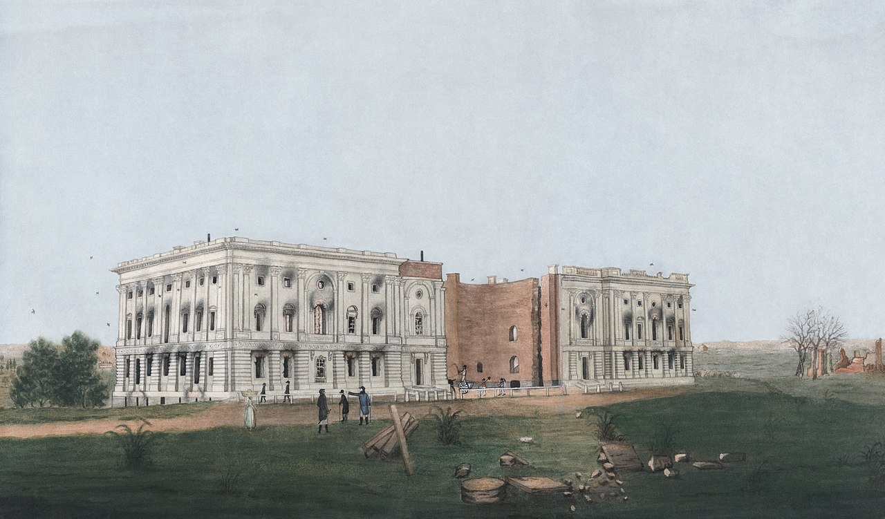
| | | | The Capitol was a prime target, for its symbolic value as well as its esthetic value. The invaders looted the building, they found it too sturdy to easily set on fire. They eventually piled furniture in a heap and ignited it with rocket powder. Several surrounding buildings also caught fire. A main casualty was the entire 3,000 volume collection of the Library of Congress. Afterwards, Thomas Jefferson famously sold his own personal library to the government to pay personal debts, but reestablishing the Library of Congress. | | | | Troops then turned northwest up Pennsylvania Avenue toward the White House, which the President and First Lady had already evacuated (see below). Assuming a US victory at Bladensburg, a celebratory supper had been prepared for them and his departmental secretaries. The British commanders ate that supper, drank the wine, and then burned the Executive Mansion. They also burned the Treasury Building, the Department of War Building, and others. The commanders stated the burning was in retribution for destruction caused by the US in BNA (Canada), particularly in the Burning of York (now Toronto). | | | | | | In 2013/4, we described the visit to the Canadian Parliament in Ottawa as being the fifth parliament I've visited. We discussed the US "Parliament", the Capitol building, along with the other four, including the partial burning by the British of both the still domeless Capitol building and the White House. Because of the two fine illustrations, I'll copy that paragraph here.
An artist named George Munger, who was an engraver known for painting portraits and miniatures, prepared two watercolor-and-ink drawings on paper to preserve the scene. The one of the Capitol shows the two burned-out wings on either side of the still unbuilt rotunda and dome. As a point of interest, this is his companion piece of the burned-out White House, which Munger referred to, in the style of the time, as The President's House. In both watercolors, the emptiness of the surrounding neighborhoods in 1814 is striking. (The S-shape above the near corner of the White House is believed to be part of a lightning protection system.)
|
| | | | Then Mother Nature had her say in the matter. While the burning was underway, a sudden very heavy thunderstorm, possibly even a hurricane, put out the fires. It also formed a tornado that passed through Washington, setting down on Constitution Avenue. Afterward, the British returned to their ships, many of which were badly damaged from the storm. The British occupation of Washington had lasted only about 26 hours. | | | | There is disagreement about the purpose of the British invading Washington, to occupy, or to destroy in retribution, and then leave. It would seem to be the latter, given the commands the officers gave and also the other, smaller raids that had been made around Chesapeake Bay. This latter line of thought would then say the storm didn't chase them away, they were leaving anyway—and it helped put out fires. | | | | Most leaders of continental Europe denounced the destruction as needless vandalism, as did, of course, most American observers. While many British were shocked by the burning, the majority of British opinion believed it to be justified, following the damage done by US forces with its incursions into BNA (Canada). | | | | Brookeville As the British entered Washington, President James Madison and his government fled first south into Virginia, but then turned north into Maryland, finding refuge late in the evening of the 26th, two days after the burning, in the small town of Brookeville. Take a look at our "blue" map to find it. He spent that night in the house of Caleb Bentley, a Quaker who lived and worked there. The Bentley House is today known as the Madison House. (Dolley Madison had instead gone to Georgetown, where she later crossed over into Virginia.) The President stayed up all night, dictating orders to his officers while soldiers kept watch. The next morning he learned the British had moved on to Baltimore, so he thanked his hosts and returned to Washington. However, Bookeville is known today as the "US Capital for a Day" (photo below).
https://www.airtronmidatlantic.com/wp-content/uploads/2015/12/Brookville-MD.jpg
| | | | Lansdowne Portrait If Americans recover from their 1812 amnesia at all, what probably does it is the story about Dolley Madison rescuing the portrait of George Washington before the fire. Thank goodness for little mercies. While the story is basically true as long as you squint your eyes, it has big holes in it. Let's start with the painting.
| | | | The picture in question is called the Lansdowne Portrait. Click to inspect the fine details of this oil-on-canvas portrait of George Washington, painted by renowned American artist Gilbert Stuart, painted in 1796. It was commissioned by a wealthy Senator from Pennsylvania and given as a gift to British Prime Minister FitzMaurice, the Marquess of Lansdowne. He was an American sympathizer who supported American independence in Parliament. This painting eventually made its way to the Smithsonian's National Portrait Gallery in Washington. To my knowledge, it has never seen the inside of the White House. | | | | When can a copy also be an original? A copy of his own work painted by the original artist might fall into that category. Gilbert Stuart painted three replicas of this, his own work. One was bought by the US government and hangs today in the East Room of the White House. This is the one that was rescued before the fire. There is also an original Stuart replica in the Old State House in Hartford CT and in the Pennsylvania Academy of the fine Arts Museum in Philadelphia. Other artists have also copied this portrait, but that falls into a lower category. | | | | Stuart cleverly used a little trick to identify his original from his own replicas. Look to the lower left of the painting at some books under the table and at the brown one leaning against the table leg. On the original, it's named "Constitution and Laws of the United States". But to identify the replicas, on those paintings, Stuart purposely left out the first T of the last word leaving "Sates", as you can see in this detail. | | | | Dolley Madison So the first hole in the famous story is that it was actually one of the original copies that was rescued and not the original. The second hole is that it wasn't quite Dolley Madison who did the rescuing. She was a very popular First Lady and a trend setter, and helped furnish the newly-built White House. She wrote about saving the portrait and legend has picked up on that and credited her with personally removing the painting, and she became a national heroine. | | | | But fifteen-year-old Paul Jennings, who was President Madison's personal enslaved manservant, was an eyewitness to the events. Years later, after buying his freedom from the widowed Dolley Madison, he published a memoir in 1865 that included a description of the evacuation. He was the one who had prepared the dinner with wine for the President's party that the British officers helped themselves to instead. | | | | No matter how Dolley Madison may have embellished her role in the evacuation, others did the actual rescuing. Once the President and officials had fled the city, and before she went dashing off to Georgetown herself, she did organize the staff to save valuables from the British, including ordering the Stuart painting to be removed. But then she hurried away to her waiting carriage, as the British were just a few blocks away. Paul Jennings reported that all she rescued personally was some silver that she carried off in her purse. She couldn't have saved the portrait herself by cutting the canvas out from the frame, he says, because it would have required a ladder to get it down. Personally, I can't picture a First Lady scrambling up a wall, even in an emergency, especially given the long dresses of the day. | | | | Jennings then identifies the French doorkeeper John Susé and the President's gardener Mr Magraw/McGraw as those who removed the painting for safekeeping. They took it down and sent if off on a wagon with some large silver urns and other valuables that could hastily be gathered together. This all confirms that, the more famous the story, the more you should take it with a grain of salt. | | | | Battle of Baltimore After Bladensburg/Washington, the Chesapeake Campaign then continued three weeks later with the adjacent Battle of Baltimore (see blue map), a mere 65 km (40 mi) away. Aside from Baltimore's proximity to their first target of the national capital, Baltimore was a busy port and the home port of many of the privateers that had been raiding British shipping, and the British also wanted to strike blows against the US economy and morale. They particularly hoped to destroy Baltimore's ship-building facilities and naval stores at the Fell's Point Naval Yard. I have not seen anything to indicate they were planning on permanently occupying the city, any more than they did Washington. It seems that again it was a mission of destruction, harassment, and demoralization, but not of long-term occupation.
| | | | However, they did not take the shorter overland route to Baltimore. Instead they returned to their ships anchored in the Patuxent River (see map), sailed south to the open Chesapeake, and then north to the Patapsco River, whose estuary forms Baltimore harbor. These three weeks gave the Baltimoreans plenty of time to reinforce their fortifications and assemble additional troops from surrounding areas.
https://www.nps.gov/nr/twhp/wwwlps/lessons/137fomc/137Images/battleofbaltimore.jpg
| | | | As both the blue map and this "Baltimore detail map" show, the British planned a combined land-and-sea operation, which is why "Battle of Baltimore" is an umbrella title for both the Battle of North Point and the more famous Battle of Fort McHenry. North Point is, as its name indicates, the northern of the two points where the Patapsco River estuary meets the open Chesapeake, and the Battle of North Point was the land operation. While the main British fleet lay at anchor at the end of the estuary, on Sunday, 12 September, some 5,000 British troops under Major General Robert Ross landed at North Point, and met heavy resistance, the defenses being far stronger than anticipated. Though the Americans had to retreat the next day, Monday, the 13th, the battle was a successful delaying action causing heavy casualties on the British, and halted their advance. One of the casualties was General Ross, who was killed by American sharpshooters. His death significantly demoralized the British troops. Colonel Arthur Brooke took charge of the British ground forces. After two days of battle, Brooke decided to rely instead on the naval battle at Fort McHenry, and, at 3 AM on Wednesday, the 14th, he ordered the British troops to return to the ships. | | | | While the Battle of North Point started on Sunday, ran Monday and Tuesday, and ended in the wee hours (3 AM) of Wednesday, the Battle of Fort McHenry ran at the same time, but was much more compact. It lasted just over a day, 26-27 hours, from sunrise Tuesday the 13th to about 7 AM Wednesday the 14th, at which point the fleet withdrew. This was about only four hours after the land troops returned to the ships. | | | | At Fort McHenry, some 1,000 soldiers under the command of Major George Armistead awaited the British naval bombardment. The defense of the fort was augmented by the sinking of a line of American merchant ships (see detail map) at the adjacent entrance to the harbor to further prevent British ships from entering. At sunrise, the British fleet of some 19 ships commenced the attack. A rocket vessel fired the newfangled Congreve rockets, and five bomb vessels fired mortar shells. Others fired cannonballs. After an initial exchange of fire, the British fleet withdrew to just beyond the range of Fort McHenry's cannons and continued to bombard the fort. As lightning flashed and rain fell, some 1,500 to 1,800 rounds were launched at the fort, yet damage was light. The mortars and rockets on the ships had a greater range and a higher arc, allowing them to reach the fort (effective mortar range 2 mi [3.2 km], effective rocket range 1.75 mi [2.8 km]). The fort's cannon had a limited effective range of only 1.5 mi (2.4 km) and had difficulty reaching the ships. However, some of these cannonballs were "hot shot", heated cannonballs that could also set the ships' wood afire, and wooden ships burned easily. As it turned out, the British rockets and mortars proved to be extremely inaccurate when firing at maximum range. It would seem that their bark was much worse than their bite.
http://www.shadedrelief.com/birds_eye/big_images/mchenry_big.jpg
| | | | This is a bird's-eye view of Fort McHenry during the bombardment. The view looks south toward the bombarding ships, with the harbor entrance lying immediately east, or left of the view. North Point is visible in the far distance on the left, with the main British fleet to its right. Note how small the actual center of the fort around the Parade Ground actually is. It's a five-star fort, surrounded by a dry moat, each bastion forming a point of the star. Soldiers can be seen occupying the dry moat to protect against a possible land attack. To the left is the ravelin, protecting the sally port of the fort proper. Just inside the bastion closest to us, the small building can be recognized as the powder magazine, such as we saw in Charleston. The two buildings on both sides of it are Officers' Quarters, and the two on the far side are Enlisted Men's Barracks. On the right, the southwest bastion can be seen taking a direct hit, killing two soldiers (four in total, with 24 wounded), while one British crewman was wounded. Still, what surprised me most on visiting the fort later was seeing the Water Battery, the long, upper and lower batteries of 26 cannon outside the fort at the water's edge, very visible in the sketch. These, outside the fort, were the main line of defense. | | | | I was most interested to learn that Baltimore had declared a blackout on the night of the attack, and all the lights in town were extinguished so as not to give additional aid to guiding the British. You can imagine how dark it would have been given the pouring rain. Only lightning and bomb flashes would give momentary illumination. | | | | | | I can imagine how difficult it would be to get everyone to cooperate properly in an era of candles and oil lamps. My own experience with blackouts was as a small child in Brooklyn in the midst of WWII, when the power company would switch off all the lights in an air-raid exercise. The adults would tense up while closing the drapes, hoping it was just a drill, but I had a great time playing around in the dark. |
| | | | There was an additional action. Just before midnight, and in the pouring rain, the British fleet command ordered a diversionary land attack as a further distraction (see detail map). They attempted to bypass Fort McHenry by making a landing of small boats to the shore just to its west, away from the entrance to the harbor on which the fort's cannon were concentrated. The hope was that the landing party of some 1,200 soldiers might slip past Fort McHenry and draw troops away from Baltimore to ease the pressure on the primary land attack from North Point, or otherwise to execute a land attack on the rear of the fort. But it was a hopeless disaster. Thinking they were out of danger from the fort's guns, they sent up rockets. But these gave up their position and made them targets for the guns at Forts Babcock and Covington (see detail map), Baltimore's last line of defense. Many of these troops either drowned or were killed in the ensuing crossfire, and most of the survivors were taken prisoner. This event dashed British hopes of capturing Baltimore. | | | | The bombardment stopped at about 7 AM, and at about 9 AM, the ships got underway. They picked up the soldiers coming back from North Point and sailed off to regroup before the fleet's next, and final, assault on the US. This—surprise!—was down on the Gulf Coast at the Battle of New Orleans, described in 2015/9. | | | | Early in the morning, at the fort, a small US flag was replaced by a large one. When discussing this, it's necessary for historical accuracy to separate out all the flag-waving stories (pun definitely intended). Too much of the following information is subject to sugar-coating by over-enthusiastic individuals, and some details might tend to get brushed under the carpet. For instance, some will insist that the large flag was flown to taunt the British, or even to "scare them away". Nonsense. The large flag was apparently always hoisted in the morning for reveille, and in this case it replaced the storm flag. | | | | I had to look that up, and the explanation is hard to come by. But it means just what it says. A storm flag is a national flag usually flown only under adverse weather conditions, such as a storm, and a tattered one had been flown during the overnight storm—and bombardment—in this case. It measured 17x25 ft (5.2x7.6 m) and, along with the firing of the morning gun, it was replaced by a larger garrison flag, 30x42 ft (9.1 x 12.8 m). This Great Garrison Flag has become known as The Star-Spangled Banner. | | | | Francis Scott Key It would seem I've left out something important in discussing this battle. To that I'll say first that I find these examples interesting of works of art helping the public to remember historical events: an overture, a painting, a poem. It was in 1882 that Tchaikovsky debuted his 1812 Overture in Moscow to commemorate the liberation of that city from Napoléon seven decades earlier; it was in 1796 that Gilbert Stuart painted the Lansdowne Portrait of George Washington, which seems to be the only thing people remember about the burning of Washington in 1814; and it was directly in 1814 that Francis Scott Key wrote his poem about the Battle of Fort McHenry, which has elevated a battle, despite its being an American win, from the depths of what would otherwise be near-total obscurity. After all, how many people remember the previous American win in this war, the Battle of Plattsburgh?
| | | | Despite the fact that 12 September is Defenders Day, a legal holiday to this day in Maryland to commemorate the first day of the Battle of Baltimore, and despite what flag-wavers would have you believe, it wasn't that important a battle, not equal in importance to the ranks of Bunker Hill, Fort Sumter, Gettysburg. It's the poem, and what that poem became, that's bolstered recollections of the battle in the minds of the public. But why was Key there? | | | | We last saw Key in Georgetown, noting the loss of his house there, near the Key Bridge (2016/15) and the events that brought him to Baltimore started near there. Look again at the blue map and note the town of Upper Marlboro MD, not far from Bladensburg. When the British arrived there on the way to Washington, the town was mostly deserted, except for its most prominent citizen, 65-year-old Dr William Beanes. He offered General Ross and Vice Admiral Cockburn the use of his house as their headquarters from 22 August to the afternoon of the 23rd (battle and burning were on the 24th). Therefore, Ross considered him to be sympathetic to the British. | | | | In the meantime, Beanes had been involved with friends in capturing some British deserters. One escaped, and went to Ross. When he briefly stopped in Upper Marlboro on his return to the ships, Ross was furious thinking he'd been misled by Beanes's hospitality. He arrested Beanes and the friends, but released the others, taking Beanes back to their flagship, HMS Tonnant, which went off to Baltimore. | | | | Friends of Beanes went to Key for help. Key got permission from President Madison, who also sent John Stuart Skinner, the US Prisoner Exchange Agent for the area. The three set off in a truce vessel for Baltimore and reached the British fleet on the 7th, a full five days before the battle. | | | | They met with Ross and Cochrane for dinner on the Tonnant, but they refused to release Beanes. Skinner knew of Beanes's high reputation, and had the foresight to collect from wounded British soldiers left behind after Bladensburg letters describing their good treatment by the Barnes and the Americans. It was only once Skinner showed Ross and Cochrane these letters that they relented and agreed to release Barnes. So once again, we see that sugar coating has influenced popular conception of what happened. While Key certainly participated in this mercy mission, he was NOT the one that tipped the scales to get Barnes released, it was Skinner. | | | | Key and Skinner were then allowed to take Beanes back to the truce ship, but because the three had been behind the British lines and were aware of their positions, they weren't allowed to be released immediately, but had to wait until the Battle of Baltimore was over, one way or another. Thus, their business in Baltimore was completed, all during the time they witnessed the events. On the Baltimore detail map, note the position of the Key's truce ship in blue, surrounded by British ships in red, all south of Sparrows Point. It was from this distance that the three of them, not just Key, observed the events—or, at least as much as they could see. | | | | The elephant in the room, of course, is that the poem based on his observations that Key started to write down on the back of a letter in his pocket, to be polished and completed later, became the US National Anthem. We'll go into that in detail shortly, but first we need to take a close look at what he was writing about. Using the then-current British spelling of what today is spelled "defense" in the US, he entitled his poem "Defence of Fort McHenry", but that title is misleading, as he did not write directly about the battle itself, and certainly not about the defending cannons located on the two-level Water Battery, which he didn't even mention. | | | | The only real reference to the Battle was not to the American defense at all, but to the British attack. He cites the Congreve rockets by mentioning the rockets' red glare and the mortars by mentioning the bombs bursting in air as being the occasional source of flickering light, perhaps along with lightning flashes, during the gloomy, stormy night, further darkened by the smoke of the gunfire. While these occasional overnight flashes gave proof through the night that our flag was still there, but when those flashes let up, nothing definitive could be seen. | | | | What Key's poem concentrated on was the contrast between the two periods of daylight. He cites having seen and hailed the American flag over the fort at the twilight's last gleaming. But what about now, at the dawn's early light? Did it survive? Is it still flying? O say, can you see the flag? Does it yet wave? Yes, it does, he finds. | | | | Key's poem is about wondering at twilight, then knowing little overnight, then attaining final resolution only in the morning. And I'll state that most of us have experienced that, specifically at election time during drawn-out presidential elections. We wonder at twilight, go to bed knowing little overnight, then attain final resolution only in the morning, if our candidate won or lost. The poster child for this election day situation is Harry Truman. He was expected to lose his bid for reelection in 1948 and spent election night back in Missouri. Although the evening before, that is, at the twilight's last gleaming, he had a slight edge in the polls, it was still predicted that he would lose, and he went to sleep. At midnight he turned on his radio and heard he could not possibly win. But at 4 AM, orat the dawn's early light, he turned on the radio again and found he was indeed winning. In 2016/3, we told how he then took the train east, and changing at Union Station in St Louis, he was handed a copy of the notoriously anti-Truman Chicago Tribune, which had, in its haste, run the mistaken headline "Dewey Defeats Truman". This is another version of the famous photograph we presented there, showing Truman's euphoria. Could Key's euphoria have been any less? | | | | Key jotted down his original notes as the battle ended on the 14th, but he and Skinner weren't released to get into Baltimore until twilight on the 16th. He was staying at the Indian Queen Hotel, apparently a tavern with rooms, where he completed the poem. It was set to a popular tune of the day "To Anacreon in Heaven", taken to a printer in Baltimore, who anonymously made the first known broadside printing on the 17th, of which two known copies survive. On the 20th, both the Baltimore Patriot and The American printed the song, including the tune it was to be sung to. It became popular, and in dramatizing the bombardment and his finally spotting the flag, he elevated the importance of the battle by expressing the feeling of the day. Soon after, 17 newspapers across the East Coast printed it. Then a music store published the words and music together, giving it the new title The Star-Spangled Banner, taken from the song's text, and also denoting the Garrison Flag it was based on. Over time it became the unofficial US National Anthem. Congress finally made it official in the Depression year of 1931. | | | | Anacreon & The Anacreontic Society It may have been in the fifth grade where we were taught that the music from the National Anthem was based on an English "drinking song" called "From Anacreon in Heaven". It sounded a little odd, but so be it. The odd skeleton in the closet is what makes history even more interesting. Now that I've been looking in to the matter, I find various opinions, some of the most conservative ones seeming to want to whitewash the story, to sanitize the odd lusty detail to present the rosiest picture possible for public consumption. So let's look at the facts and make up our own minds. | | | | There was a Greek lyric poet named Ἀνακρέων /Anacreon who lived in the 6C BCE. Like all early lyric poetry, it was meant to be accompanied by music, usually on the lyre. His poetry touched on love and infatuation, but also on revelries, parties, and festivals. He was therefore notable for his drinking songs, which celebrated women, wine, and entertaining . From his name we get the fancy word "anacreontic", which means "praising love or wine" (sounds like a wild party), and also "being amatory or convivial" (the party gets wilder yet). Does "amatory" mean "erotic"? If you look at this in a stuffy way it will seem milder, but look at it more blatantly and you'll see that Anacreon is really urging you to take down your hair and paint the town red. | | | | The Anacreontic Society is described as an "elite" 18C "gentleman's club" of "amateur musicians" in London. It consisted of barristers, doctors, and other professional men. It met every two weeks to get drunk, sing songs, and indulge in some debauchery. They had an official song, written for it probably around 1771, called The Anacreontic Song, but often referred to by its first line, To Anacreon in Heaven. Though credited to John Stafford Smith, the tune is now thought to have been written "collectively'' by society members under his direction. Take note of the lusty lyrics of "To Anacreon in Heaven". | | | | If your mind is set at "lofty" because this refers back to a Classical Period, then the 18C bawdiness might not be immediately apparent. So set your mind to "blatant" as you reread the line, which is repeated, where Anacreon says "I'll instruct you, like me, to intwine / The Myrtle of Venus with Bacchus's Vine". You can guess where Venus keeps her myrtle, how long Bacchus's vine is, and what happens when they intwine them. This "instruction" the Gentlemen are getting from Anacreon is Sex Ed 101 à la 18C. I really have to shake my head when I see people online trying to say this delicious bawdiness is just some gentlemen amateur musicians in a stuffy old wood-paneled club room. It was because of the bawdy lyrics of this song that it gained such huge popularity, in Britain and overseas, well beyond the Anacreontic Society. | | | | Listen to this YouTube recording (2:25) of To Anacreon in Heaven. The tune will be obvious, but also note the illustration of the "Gentlemen's Club" that is used. While the illustration looks medieval, it gives an idea of what the song is referring to. The Venus/Bacchus line is at about 0:45. | | | | I'm going to be bold here and suggest two things for you to compare with the above as (1) being a bawdy song and (2) reaching wide popularity as such. The first is to recognize how today, the term "Gentleman's Club" is often used to describe a strip club, even if it is a high-class one. The other is to have you listen to David Rose's 1962 recording of his instrumental called "The Stripper" (1:58). While it has no lyrics, the title points you in the right direction, and it evinces an erotic jazz influence with the especially prominent trombone slides. In July, 1962 it reached number one on Billboard's Top 100; became a gold record, and was ranked by Billboard as the No 5 song of 1962. Consider the bawdiness of this having made it popular, and consider the same for the older song. | | | | Before we move on, we have to look at this plaque (Photo by Edwardx) in Gloucester Cathedral to John Stafford Smith. This is such a perfect example of idealized, selective recollection of history, jumping from A to Z, leaving out everything in between. It cuts to the chase, skipping over the fact that Smith actually wrote the song for a lusty "social" club, and that it was only later adopted by Key, with Smith having absolutely nothing to do with it! | | | | The Tune Gets Sanitized I'd have a very hard time seeing someone take the tune of "The Stripper", sanitizing it of its juicy bawdiness, and using it as the tune for a much more benign song, but that's exactly what happened to the bawdy Anacreontic Song. I've read that the melody was so popular, that it was used frequently for ballads in Key's era, with over 80 Anacreontic lyrics appearing in print before 1820. I know nothing about most of them; maybe some continued to be bawdy. But there are three examples I can present of the melody being used for political and/or patriotic purposes. | | | | The first one is Adams and Liberty, a song that is considered the first significant campaign song in American political history. It was used to support the incumbent President, John Adams, in the Presidential election of 1800. The new lyrics written in 1798 for the Anacreontic Song were by Robert Treat Paine Jr. This is the YouTube recording by folk singer Oscar Brand of "Adams and Liberty" (1:38). | | | | The other two are an oddity, because they're by the same person, Francis Scott Key. He wrote one in 1805 and the other nine years later at Fort McHenry, in 1814. The 1805 piece was written at the end of the First Barbary War (1801-1805) fighting piracy on North Africa's Barbary Coast. Key wrote When the Warrior Returns to honor two naval heroes of that war on their return, Stephen Decatur and Charles Stewart. This is a YouTube recording (3:24) of "When the Warrior Returns". After three verses from this selection, this recording oddly includes verse four of the Star-Spangled Banner, which can here be disregarded. But do note the line at 1:49 that includes the phrase "Star Spangled flag", a precursor to the later "Star-Spangled Banner". | | | | It would seem that now is the time for us to disabuse ourselves about any preconceived notions we may have about the Star-Spangled Banner. If we thought the text was made of whole cloth, that is, was a totally original concept conceived on the truce ship, we see that to be inaccurate; its form and some phrases were recycled from the 1805 piece. If we thought putting the piece together with the tune was as later accident, that also wasn't the case—he'd used the tune before. As a matter of fact, some will argue that it wasn't a matter of a poet writing a poem, that somehow got set to music, but rather of a lyricist writing lyrics for a melody written by someone else. | | | | Let's look at the documentation we referred to earlier. Now on display at the Maryland Historical Society, this is Key's original manuscript (click) of his poem. We'll just look at the first, best-known verse. Immediately noticeable is the correction in the first line. He'd originally liked "through the dawn's early light", but then finally decided on "by". But there's another, much more subtle change, one between using singulars versus plurals. Look at line 5. Where today we have "bombs bursting in air", plural, Key wrote "bomb", singular. A bit more subtly, where today we have "the rockets' red glare", plural possessive, he had "rocket's", singular possessive. Today we understand the line to include the massive illumination of the ensemble of rockets and bombs, but Key was describing a simple flash from a bomb here, the glare of a rocket there. The grammatical difference is subtle, yet distinct, and it can be seen that Key meant the available illumination to be much more subtle as well.
| | | | We mentioned the broadsides (posters) that were displayed only days after the battle. This is a scan of one of only two surviving copies of that 1814 broadside, today in the Smithsonian. You'll note on line 5 that the two words are already in the plural at this stage. Also notable is the instruction as to the tune. | | | | It's probably appropriate to show at this point the actual Star-Spangled Banner that inspired the lyrics on display at the Smithsonian's National Museum of History and Technology. There's necessarily a bit of optical illusion involved. Early in its history, so many pieces were cut off the flag and given away as souvenirs that in 1914, a linen backing in the proper colors was attached to the back to actually demonstrate the original extent of the flag. | | | | Considering again the texts, the poetic structure of the Anacreontic Song is actually quite unique. While four-line stanzas are typical, it instead features eight-line stanzas, and these eight lines contain five rhymes; not only do the four couplets each have the expected end rhyme, but line 5—that line again—has an extra medial rhyme with the end of both lines of that couplet, making a three-way rhyme. This will be clear in a moment. But because both of Key's songs fit this very precise structure exactly, it's greatly implausible that he could have written these and then only after the fact, noticed that they happened to fit that melody. It was all pre-planned. | | | | This is the first verse of "When the Warrior Returns" of 1805: | | | | | | When the warrior returns, from the battle afar,
To the home and the country he nobly defended,
O! warm be the welcome to gladden his ear,
And loud be the joy that his perils are ended:
In the full tide of song let his fame roll along,
To the feast-flowing board let us gratefully throng,
Where, mixed with the olive, the laurel shall wave,
And form a bright wreath for the brows of the brave.
|
| | | | We note the eight-line stanza. Let's check the rhymes. Key intended the rhyme scheme for the end rhymes to be ABABCCDD. He was not fully successful. The hoped for A rhyme of "afar" and "ear" falls totally flat. The words don't rhyme, they just look as though they might. The C rhyme is just as bad: "along" would rhyme with "song"—and it DOES, since that's the internal rhyme—but it doesn't rhyme with "throng", which would rhyme with "gong". The D rhyme of "wave" and "brave" is fine, and that was one element Key recycled in 1814, along with the "Star Spangled flag" we saw coming up in a later verse. Now let's compare this with "The Star-Spangled Banner" of 1814: | | | | | | O say can you see, by the dawn's early light,
What so proudly we hailed at the twilight's last gleaming,
Whose broad stripes and bright stars through the perilous fight,
O'er the ramparts we watched, were so gallantly streaming?
And the rockets' red glare, the bombs bursting in air,
Gave proof through the night that our flag was still there;
O say does that star-spangled banner yet wave
O'er the land of the free and the home of the brave?
|
| | | | Again the eight-line stanza, but Key's skills have improved. He still uses ABABCCDD, and they all work perfectly. Line 5 still has the medial rhyme, and look how nicely he rhymes "glare" with "air" and with "there". And again we see the recycled D rhyme of "wave" and "brave". | | | | "Star-Spangled" But I continue to have a problem with Key's made-up word "star-spangled", used in both poems. It's a flashy word that turns out to mean nothing of substance. The most accurate nickname for the US flag is the "stars and stripes", which describes the entire image. Key even referred to the broad stripes and bright stars on the flag. You'll recall our recent discussion (2016/16), where we mentioned that the First National Flag of the Confederacy was called the "stars and bars", which struck a reasonable parallel to "stars and stripes". I always assumed that "star-spangled" also somehow included the stripes, but it doesn't, and turns out to be an incomplete designation, that ignores the stripes on the flag, which are just as iconic and should be mentioned somehow. | | | | I only knew that a spangle was something flashy, worn perhaps on circus costumes. I had to look it up, and the definition turns out to be quite simple. A spangle is a sequin with a difference. A sequin has a central hole through which it is sewn on flat to the fabric, while a spangle has a hole at its edge, so when it's sewn on, it hangs free, allowing for more movement and sparkle. I've found online this picture:
https://ae01.alicdn.com/kf/HTB1nR8oLXXXXXb.XXXXq6xXFXXXN/23g-500pcs-Mixed-Star-Laser-font-b-Spangle-b-font-font-b-Sequins-b-font-Paillette.jpg
| | | | These are spangles in the form of stars. You can see the holes at the edge, not in the center, so that they can jiggle when the wearer moves. Call them sequins on steroids. I realize that Key was speaking poetically, but it would then seem that "star-spangled" is overkill. It doesn't describe stars sedately on a flag, but would seem to mean flashy stars shimmering to catch the eye on a used-car dealership, which is more than just a little off-key (pun intended). But more important, it makes no reference whatsoever to the other element of the US flag, the stripes. Perhaps something like "The Stars-and-Stripes Banner" is closer to the mark. | | | | To complete our series of musical selections based on the Anacreontic Song, we'll include this YouTube rendition of The Star-Spangled Banner, which uses an interesting selection of accompanying photographs. | | | | Fortified with this considerable background, we'll sail right through these historic waters tomorrow as we enter Baltimore, the last stop of the trip. | | | |
| |
|
|
|

