|
Reflections 2014
Series 8
June 25
China XVI: Tibet I: Politics & Geography - Altitude Ups and Downs
| | Ah, the Great Rail Adventure to Tibet. Yet I must be frank. If Tibet were all three of the following: (1) independent, (2) at sea level, and (3) without a spectacular train route to it, its culture alone would not have attracted me to go to all the trouble to visit it. In other words, its remote culture is probably fourth on the list of what attracted me. There are other countries—and I use that word including Tibet as a country—whose cultures might be the prime attraction for me or for anyone else, but for Tibet to me it's the politics, geography, train route—then culture. Below we'll discuss, just superficially, the volatile ▲ politics of Tibet, then, more fascinating, the extraordinary ▲ geography of Tibet. In the next posting we'll cover the spectacular ▲ train route to Tibet. and then finally, Tibetan culture as we saw it in ▲ Lhasa. | | | | The Politics of Ethnicity For centuries, the template used for establishing countries was from the top down. A king or emperor conquered a neighboring area, no matter if it was of the same ethnic group or not, and made it part of his country. Alternatively, royal weddings were arranged, which merged two regions into one country, and again, ethnicity had little or nothing to do with it. It was all a hunger for royal or imperial acquisition. | | | | Then, starting slowly in the 19C, the template was gradually altered. Change began to rise upward from below in the form of ethno-cultural and linguistic assertion. A good example is the formation of Greece. It had been part of Turkey's Ottoman Empire, but after its war of independence, the Greek state established itself in 1830. Greece is an early example of ethnicity and language being the basis for independence from a larger power. | | | | But in our recent discussion of the Norse in Scandinavia we came across another example of division along ethnic and linguistic lines. At various times, southern Sweden (Skåne) was part of Denmark; Norway and Denmark were one country; and Norway and Sweden were one country. Yet, as similar as their cultures and languages are, they separated themselves along linguistic lines. | | | | That ethnicity was the basis for country formation in modern times became most apparent in the 20C. You may define the 20C as being a full hundred years, or may do as I like to do on a practical basis, define a "short 20C" lasting only 75 years, from 1914, with the start of WWI, to 1989, with the fall of the Berlin Wall. This conveniently leaves the few years before 1914 as an extended 19C (the Edwardians were similar to the Victorians), and the decade after 1989 as an early start of the 21C. This "short 20C" is a time of two World Wars followed by a Cold War, and saw the rise and fall of Nazi Germany and the rise and fall of the Soviet Union, both of which were extended consequences of WWI. Nevertheless, this short 20C (or the full 20C if you wish) saw the emergence of countries on an ethno-cultural and linguistic scale like never before. | | | | After WWI, a major power like Austria-Hungary broke down into numerous countries based on ethnicity. A strong proponent of this was US President Woodrow Wilson, and, I must say, I myself have always been a Wilsonian in these matters. One would have thought that that would have ended it for the former Austria-Hungary, and stabilized the area, but it did not. Two countries established at that time broke down further years later. One involved grouping the Czechs and Slovaks into a single country, Czechoslovakia. It was thought, that they, being so similar, could have made a go of it, but they later broke apart under the same ethno-linguistic tensions as Scandinavia, above. And it was thought that grouping all the South Slavs except the Bulgarians into Southslavia would have worked (they didn't actually use the English word, but the Slavic word for "south", "yug", with a connecting O, so Southslavia was actually called Yugoslavia). But we all know how Yugoslavia exploded violently into its component ethnicities. The breakups of Czechoslovakia and Yugoslavia were delayed reactions, still within the "short 20C", of the breakup of Austria-Hungary. | | | | The Ottoman Empire broke down then, but no attention was paid to the Kurds, so they are still trying to form a Kurdistan. And who would have thought the trend would have hit Great Britain? But most of Irelandbroke away in those years. When the French left Indochina, it split up into its ethnic components, Vietnam, Laos, and Cambodia. And right at the end of our short 20C, even the Soviet Union, which had carefully subdivided its major ethnicities into component "republics", saw that structure break down into actual independent republics. And not as well as could have been. A large slice of Russia had been foolishly included within the borders of eastern Ukraine, and worse, in 1954 Khrushchev imperiously transferred Russian Crimea to Ukraine as well. While Putin today has no right to take back Crimea or to instigate unrest in the Russian part of Ukraine, this is once again a reflection of the importance of ethnicity and language in establishing borders. As much as Ukraine might try to go it alone with the status quo, or even try to federate itself into Ukrainian and Russian parts, even that move would be counter to the contemporary trend of ethnic unity. | | | | This is by no means a definitive list. Furthermore, breakups along ethnic lines don't HAVE to happen, but the trend has been obvious for a long time. Scotland will vote on independence from Britain on 18 September. Québec has had votes in the past on independence from Canada. The ethnic groups in Belgium, the Dutch-speaking Flemings and French-speaking Walloons, have been at odds with each other for a long time. Catalonia has talked about leaving Spain. None of these moves toward ethnic independence has to happen, but even if nothing does in the short term, the underlying ethnicities will continue to remain a factor in political thinking for a long time to come. | | | | Ethnicities & Borders in China So let's finally look at China and its minority ethnic groups. It has hundreds of small ethnicities, just as Russia does—think of Chechnya, which is still part of Russia. In both Russia and China, these smaller ethnic groups are for the most part just too small to consider independence on a practical basis. But then you never know—consider again Chechnya and events there. But here's one guide: just as the Soviet Union had divided itself into "republics" for its larger ethnicities, so has China divided itself into "Autonomous Regions". These beg to be looked at more closely, something we first did way back in 2009/29, when we were discussing, in preparation of the Japan trip that year, the ethnicities of East Asia as well as their writing systems. | | | | We need to compare two maps that we used in that earlier posting. This first one is an ethnolinguistic map of China (no attribution). While there are 56 officially recognized ethnicities within China today, only the most populous ones have special regions put aside for them. The green-gold area in the east shows the Han Chinese, or, if you will, the "Chinese Chinese". If China were ever to "explode" into its major component ethnicities as Austria-Hungary did in 1918 and the Soviet Union did in 1991, this could possibly be what remains as the core area of "Chinese" China. Beyond that, note five major groupings: ▲ the yellow area to the south shows the Zhuang people, whose languages are related to Thai; ▲ clusters of triangles, particularly in the center, show the Hui people, who are Chinese Muslims; ▲ the lilac area to the north shows the ethnic Mongolians; ▲ the pink area to the west shows the Uyghur people, ethnolinguistically Turkic; ▲ the gold area shows ethnic Tibetans. Also note the uninhabited areas adjoining the latter two regions. | | | | Now take another look at the map of the Administrative Regions of China (Map by Ran). Other than territorial disputes, most notably Taiwan, Han China is divided into provinces in pink and major municipalities in light blue, plus Hong Kong and Macau. It's the five beige areas that correspond to the major ethnic minorities: in the south is the ▲ Guangxi Zhuang Autonomous Region (AR), which was formerly a province, but which was converted into an AR in 1958 to accommodate the Zhuang, since they were the largest minority group among the Han and were 90% concentrated here; in the center is the ▲ Ningxia Hui AR also converted from a province in 1958 to accommodate the Hui people; the ▲Inner Mongolia AR, the ▲Xinjiang Uyghur AR, and the ▲ Xizang (Tibet) AR. | | | | No one knows what could happen if cataclysmic change were to come to China; perhaps little or nothing, perhaps a new collapse like Austria-Hungary or the Soviet Union. But to start with, there are apparently no indications of the Zhuang or Hui areas being restless or independence-minded in any way. | | | | I've always been confused about the Inner Mongolia AR, and new information I've found confuses me yet more. If the former Outer Mongolia became the independent state of Mongolia, why did the former Inner Mongolia remain apart and become the Inner Mongolia AR of China? What I now find is this. The AR was established in 1947 to accommodate a majority Han population, which is today 79.2%, beside the substantial Mongol minority of 17.1%. The official languages are both Chinese and Mongolian, and, as we said in the last posting, although Mongolia has adopted a version of Russia's Cyrillic alphabet, the AR retains the older Mongolian script. With a minority Mongol population, I suppose I can see why it wasn't joined to Mongolia. But if four out of five people in the Inner Mongolia AR are Han Chinese, it seems odd that they should name the entity after a minority group. Still, from this information, it would be unlikely if what looked like two Mongolias would ever join, should major change come about. One possibility could be indicated by the little circles in the Mongolian area on the ethnolinguistic map, which indicate concentrations of Han Chinese within the population. These concentrations could be the basis of partition of the area between China and Mongolia. Or not. | | | | | | When discussing the Great Wall of China in 2014/7, we used this map to illustrate it. It's of interest to note that traditionally, so-called "Inner Mongolia" was not part of China but outside the Wall. But then, so was Manchuria, and we know that both the Mongols and Manchus took over China, each in their own epoch. So if Manchuria remains within China, perhaps that's a basis for at least part of Mongolia to do as well. |
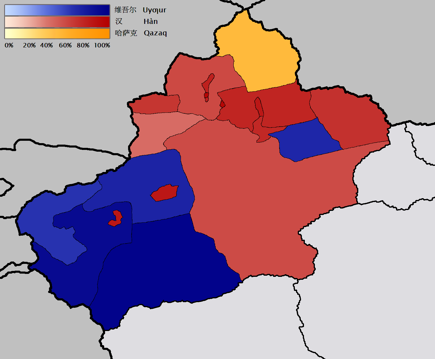
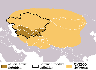
| | | | The Volatile Politics of Tibet (et al) That leaves us with not one, but two potential tinderboxes, both of which are the basis for this entire exercise centering on Tibet. We are all aware of the Tibet situation on the world stage, but not everyone is fully familiar with the Turkic ethnic group called the Uyghurs. In 1955, Xinjiang Province was renamed Xinjiang Uyghur Autonomous Region. The Uyghurs, the majority of which adhere to Islam, form 46.42% of the population of the AR, with the Han accounting for 38.99%, so the Uyghurs are in the majority, but not by too much. [To pronounce "Uyghur" as it usually is done in the West, say "weaker", then change the K to a G, although the native pronunciation is more like u.i.GUR.] | | | | There are regular articles about the Uyghurs in the papers. Notable were the riots in July 2009 in the capital city of Ürümqi, which began as a protest and built into a three-way conflict between the police, Uyghurs, and Han Chinese. Hundreds died and a couple of thousand were injured. Ürümqi (u.RUM.chi), with over three million people, is the largest city in the west of China and was a major hub on the Silk Road during China's Tang Dynasty. China's government continues to repress the Uyghurs in favor of the Han population in areas such as the awarding of contracts to business groups and to individuals. According to the New York Times on 12 May 2014, three prominent Uyghur men were jailed for opening several Uyghur-language kindergartens. | | | | The Uyghurs are spread across East and Central Asia. While the majority of them are concentrated in the AR, there are significant communities in the adjacent Central Asian countries of Kazakhstan, Kyrgyzstan, and Uzbekistan. | | | | Unlike most places in China, there is an ongoing underground separatist movement in the AR of Uyghurs who would like to have an independent country. They claim they were invaded by China in 1949 and have been under Chinese occupation since. China claims the region has been part of China since ancient times, but then that is the old royal/imperial point of view of expansionist multi-cultural states—see Austria-Hungary and the Soviet Union. The separatists refer to the region as East Turkistan, although one faction wants to see a Uyghurstan. | | | | It seems that most Uyghurs in the AR, 80%, are concentrated in the southwest region of the AR (no map attribution given), as shown on this government ethnic map of prefectures, with the Uyghur regions in blue and Han in red. If this is accurate, it would seem that a division of the territory could be made along ethnic lines. But this more activist 1949 ethnic map issued by the Uyghur Congress looks at the situation differently. | | | | Remembering that China is an East Asian country, one should look at what's considered to be Central Asia (Map by Lyriak), the core area of the Eurasian continent, as this could impact not only the Uyghurs, but also the Tibetans—even the Mongolians. First, as a rule of thumb, one can use the colloquial reference to the " 'Stans", since the names of so many countries—but not all--in the region end with the Persian suffix -stan meaning "land of". | | | | On this map defining Central Asia, the most limited definition included just some of the 'Stans that used to be part of the Soviet Union (in brown), Uzbekistan, Turkmenistan, Tajikistan, and Kyrgyzstan, but shortly after independence, Kazakhstan was added to that group (within black line). | | | | But there are two other ways to look at this area, with similar results. UNESCO defines the region on the basis of climate, and adds to those first five 'Stans (counterclockwise on the map) northeastern Iran, Afghanistan, Kashmir with adjacent areas of Pakistan and India, Tibet, the Uyghur AR, Mongolia, and southern Russia. | | | | Similar in effect is to define Central Asia based on ethnicity, which would include the Eastern Turkic, Eastern Iranian, and Mongolian peoples. Overlaying those ethnicities on current borders would yield the five ex-Soviet 'Stans, plus Afghanistan, the greater Kashmir area, Xinjiang Uyghur AR, Tibet, Mongolia, and the Turkic regions of southern Siberia. | | | | Finally, on a more limited basis for the Uyghurs and not affecting Tibet or Mongolia is the definition, not of Central Asia, but of Turkestan, just the area inhabited by Turkic peoples within Central Asia. The concept of Turkestan adds to the five ex-Soviet 'Stans (1) additional Turkic Regions in southern Siberia and (2) the Xinjiang Uyghur Autonomous Region, explaining the usage of the name East Turkestan alongside Uyghurstan. | | | | It's important to understand this whole ethnic concept when considering the western part of China and finally, Tibet. I have no intention of preaching to the choir about China's touchiness on this subject. Any foreign traveler who wants to go there has to have, in addition to a Chinese visa (with an exceedingly long application form) a Tibet Certificate, which is not issued easily, and is more likely issued to groups than to individuals, although that restriction flip-flops regularly. China restricts demonstrations in Tibet, and remains wary of self-immolations, in Tibet or, as we saw, on Tien'anmen Square. China has reshaped Tibetan culture, religion, and government, and is wary of people in other countries receiving the Dalai Lama. Just last month, people were outraged when the leaders of normally politically-tolerant Norway, in deference to China, snubbed the Dalai Lama during his visit to Norway to commemorate his receiving the Nobel Peace Prize there 25 years ago. | | | | We noted on our administrative map of China that the Tibet AR is also called the Xizang AR; each name can be shortened to just Tibet or Xizang (X=SH, Z=TS). On the basis of China's annexation of Tibet in 1951, the AR was created in 1965. In 2009, the population of the huge, but very sparsely populated AR was just under 3 million, due to the harsh and rugged terrain. Ethnic Tibetans accounted for 92.8% and Han Chinese 6.1%. However, most of the Han were recent migrants. | | | | We mentioned a Han "economic invasion" of the Uyghurs. I have a personal example of a similar "invasion" of Tibet. While our guide in Lhasa was Tibetan—I told her privately I was glad she was—the driver we had was not only Han Chinese, he didn't even live in Tibet. When the tourist season starts, his job is to drive his tour bus from his home somewhere in central China to Tibet to work, and at the end of the season, he would end his temporary move and go back to his home in China until the next year. We were also told this sort of thing is not atypical. | | | | I've also read that some ethnic Tibetans claim that, with the completion of the railway into the Tibet AR in 2006, there has been an increase of migration of Han Chinese into Tibet via the railway. The Dalai Lama's administration claims that the Chinese government is doing this to alter Tibet's demographic makeup. | | | | Since the AR was created, China—and unwary outsiders—identify Tibet with just the AR, but the current borders were established in the 18C and include only about HALF of ethno-cultural Tibet, a fact which makes the story even more interesting. Just where IS the real Tibet? | | | | Let's start with a map showing the Tibetan Empire (Map by Javierfv1212) at its greatest extent, during the 780s and 790s CE. It included the entire Tibetan plateau, not just its southern half. In the south, it overflowed into today's India and Kashmir. In the north, it even included Ürümqi, the present Uyghur capital (the Uyghurs were beyond), and Kashgar, where the Silk Road split into separate routes around the Taklamakan Desert in the Tarim Basin. In the east, it hugged Han China very closely and covered the western half of Sichuan Province. It also included the Silk Road city of Lanzhou, and came quite close to the Silk Road's goal, the Chinese capital at Chang'an, which, as we've learned, later declined and is today within the city limits of Xi'an. We'll come across some of these names I've just mentioned again later. | | | | That was the historical map. For current ethnicity, you can refer back to the earlier map, but you'll see that this ethnolinguistic map of Tibet gives much the same information. It shows that Tibetans live, in the older Wade-Giles spellings, in most of Qinghai Province (partially with Mongolians) and in the western half of Sichuan Province. We also see again, marked "uninhabited", the Taklamakan Desert in the Tarim Basin, which is today part of the Uyghur AR. | | | | Let's now get an advance look at some geography. Tibetans are known to be a people of the Tibetan Plateau (Map by Mak), and this map shows the high levels of the plateau quite clearly, as well as current Chinese provincial boundaries. Most of Qinghai and Sichuan are on the Tibetan Plateau. It's also obvious how the desert in the basin fits snugly against the plateau. | | | | Let's look at boundaries. The brown line encircles what Tibetan exile groups call historic Tibet. We can note three other things in advance from this map. The lake in the upper right, as I learned in advance before seeing it from the train, is Qinghai ("Blue") Lake, the largest lake in China, and the entire province takes its name from it. Golmud to Lhasa is the route of the Tibet train, and Shigatse is where the train line has been extended to, beyond Lhasa. | | | | As it turns out, the Chinese have recognized that there are ethnic Tibetan areas outside of the Tibet AR (Map by Ran), and have accounted for that fact by establishing Tibetan Prefectures and one Tibetan County in other provinces, as this map shows. Some of the prefectures are ethnically mixed. Yet it would seem the Tibetans are not fully satisfied with this. It brings to mind the Soviets setting up their "republics" for major ethnicities and, when push came to shove, the "republics" went independent along those lines—which could happen with Tibet. | | | | For the final political map, get ready for your jaw to hit your chest, as happened to me when I first saw it. You'll have to copy and paste this link into another window:
http://i.imgur.com/otX51NB.jpg
| | | | This is obviously a fantasy map, and includes what we've been discussing about major ethnicities in China. The gall of the mapmaker is palpable—I won't discuss it further. Digest what he has shown, and remember Austria-Hungary and the Soviet Union. | | | | Unfortunately, the mapmaker weakens his point about adding one more 'Stan to the numerous other 'Stans. He does show three of them (there's an H in Afghanistan) but he fudges on showing Tajikstan and Kyrgyzstan, which also border China today and would therefore also border a nascent East Turkestan (Uzbekistan and Turkmenistan are further west). | | | | | | Simply as a geographic exercise, see if you can find two outright mapmaking errors on this map.
Vietnam is today one country and Russia is technically the Russian Federation, not the Russian Republic.
|
| | | | The Extraordinary Geography of Tibet To understand the geography of Tibet, we need to look again into the geology of Tibet, which made Tibet what it is. In 2013/16, we discussed Pangea, or "All-Earth", the original single "parent" continent whence all of today's continents came, which first formed about 300 million years ago. Look at it again by copying and pasting this link in another window, then clicking to enlarge it:
http://eatrio.net/wp-content/uploads/2013/01/10.-pangea_politik.jpg
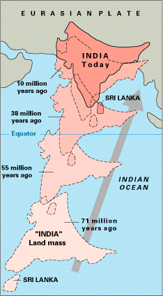
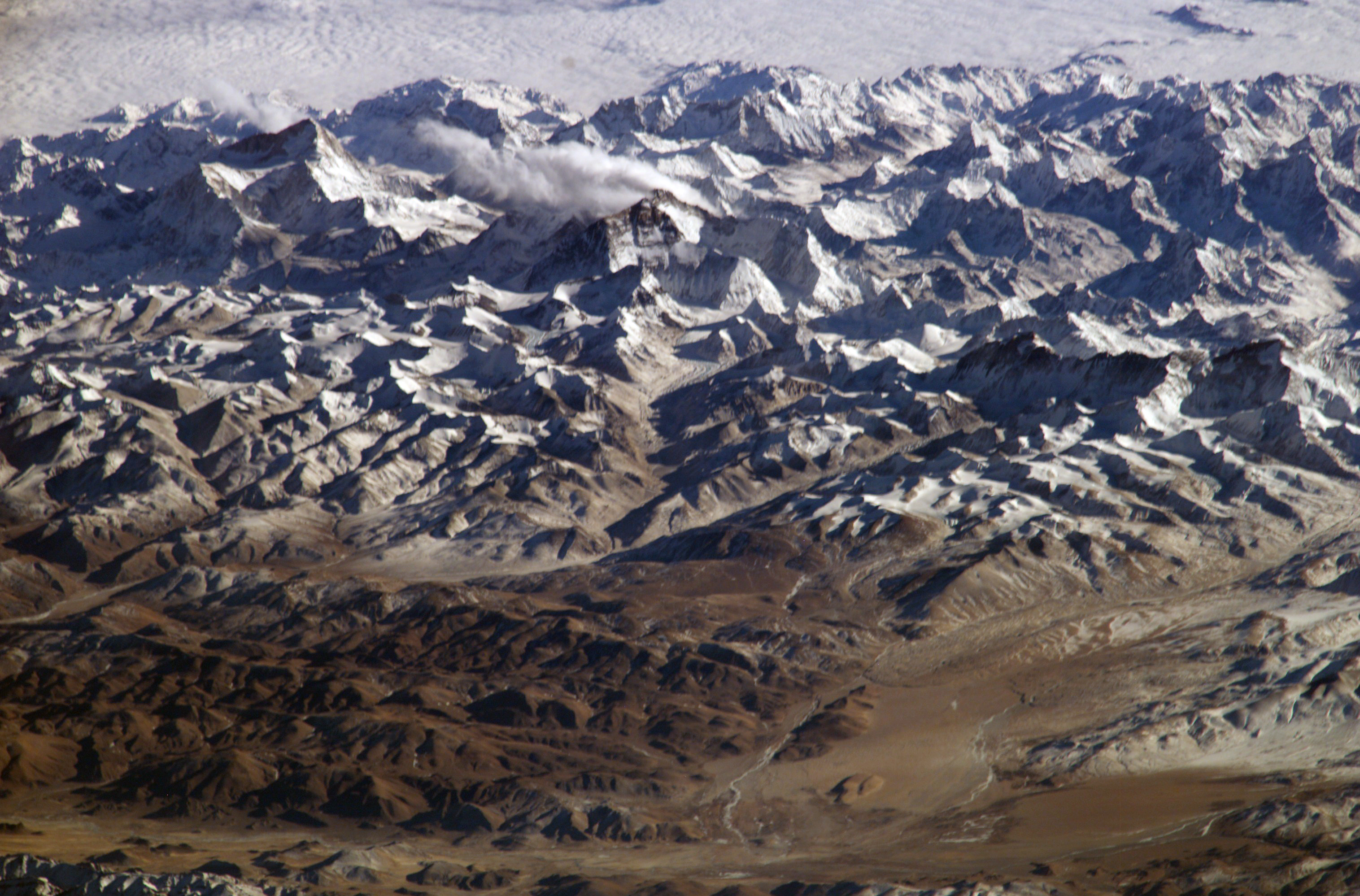
| | | | The shortened version of the characterization in the earlier posting is that, 200 million years ago, three changes started to come about. The first was called THE HOME CONTINENTS DRAW TOGETHER, meaning that Eurasia and Africa drew closer into what is in actuality a triple continent, Afro-Eurasia. Then there was THE WESTERN SPLIT, where both Americas sliced themselves off Pangea like a crust off a slice of bread and moved west, which had two hydrographic results. The space they vacated became the Atlantic, leaving the counter-space between the west coast of the Americas and east coast of Eurasia as the huge Pacific. | | | | But it’s the third move that concerns us here, THE SOUTHEASTERN SPLIT, where a potential tri-continent located to the southeast of Africa also broke away, but split up into what are actually three almost-equal sections, which I like to refer to as the "three sisters", each of which had a very different fate from the others. | | | | Miss Australia (along with New Zealand and New Guinea) is the sister that had the most straightforward, mundane fate. She traveled east from Africa across what is now the Indian Ocean (which she helps delineate), settled down in the South Pacific in a remote area giving rise to her being known as "the land down under", and lived happily ever after. | | | | Miss Antarctica is the sister that had a disastrous fate. Searching for adventure, she started out in an unfortunate direction, traveling south from Africa towards the South Pole. Like Amelia Earhart, she was never heard from or seen again. It's believed that she lies somewhere under the huge icecap that covers the South Pole. | | | | Miss India was the madcap—some would say irresponsible--sister that went dashing off at high speed in her sports car. She sped from Africa to the northeast, across what is today the Indian Ocean (which she also helps define, and to which she lends her name), and ended up RAMMING her sports car and herself right into what had been the flat, south coast of Asia. Now when two vehicles of equal size collide there is a degree of equilibrium. But when a low sports car rams into a tractor-trailer, there's no contest. The low sports car ends up UNDER the chassis of the huge vehicle. Thus was the sad fate of Miss India. Her sports car attached itself to (and under) the tractor-trailer, and there it remains. Thus, Miss India suffered the fate of losing her independence as a true continent, and has since borne the designation of a mere sub-continent, attached to the larger "vehicle", Asia. And "sub-" there applies in both definitions, that of being secondary, and also that of being underneath, because part of India lies underneath Tibet. Close inspection of the Pangea map shows that Pakistan, Nepal, Bhutan, and Bangla Desh were in the car with Miss India and took the same wild ride, while the easternmost part of today's India (between Bangla Desh and Myanmar/Burma) always lived in Asia. | | | | We use this little story as an illustration, but India really did take this wild ride, and it's worth characterizing it as "wild" because of the speed involved. Some 70 million years ago, India, that is, the India Plate, started its journey of over 6,000 km (3,700 mi) to collide with the Eurasian Plate. Now as we speak, the tectonic plates of North America and Europe are separating at the rate of about 2.5 cm (1 in) per year. But the India Plate made its journey at about 15 cm (6 in) per year, or six times as fast. Miss India was a wild-driving speed demon. | | | | When speeding India rammed into Asia (in slow motion), two things happened. While sometimes one plate will subduct downward into the Earth's mantle when this happens, in this case, that didn't happen. Where they collided, the earth's crust was folded into mountains—think of a snow plow pushing snow into a pile--and so we have the Himalayas. Proof is that the summit of Mount Everest is made of marine limestone from an ancient ocean. | | | | But the second thing that happened is that, after the initial collision, India didn't stop. It continued being driven horizontally under the Himalayas and proceeded to form the Tibetan Plateau north of those mountains. On the Pangea map, where it shows Tibet attached to India, it doesn't mean Tibet took the ride. Tibet was already in Asia, and just became uplifted. Think of a house being raised while a new basement is being built underneath. Or, think of the bedclothes (Tibet) being raised when you swing your legs (India) in underneath them. | | | | But the story gets even better. India keeps moving northward. Therefore, the Himalayas keep rising at about 5 mm (0.2 in) per year, making them geologically active. But with India still pushing north at 67 mm (2.6 in) a year, making the region seismically active with occasional earthquakes, "Underground India" over the next ten million years will continue traveling into Asia about another 1,500 km (900 mi). It would seem that India will eventually be located underneath Siberia, forming a huge extension of the Tibetan (Siberian?) Plateau. | | | | The above information has been reported online, but it would also seem to me that as India keeps moving north, the presently exposed area of India will end up hidden underground. After southern India moves under Tibet, and beyond, wouldn't it seem logical that Tibet would be lowered back down to sea level as it originally was? These last thoughts are just my own, but seem logical. | | | | In any case, Miss India doesn't seem to want to give up. To continue the metaphor of the legs under the bedclothes, let's say you skootch across the bed, legs (and plateau) constantly moving across, and get out on the other side. Will India eventually emerge from Asia through northern Siberia? Will India leave Asia entirely, become an independent continent again, and emulate in the Arctic its sister, Antarctica? Only time—lots of it—will tell. | | | | Well, that's the geology. Let's see how that affects the geography of Tibet, most obviously ● the Himalayas and ● the Tibetan Plateau. I always thought—maybe others did as well--that this entire high region north of the plains of India was the Himalayas, and am now better informed. The Himalayas run primarily along the long southern edge of the Tibetan Plateau for about 2,400 km (1,500 mi). In the west the mountain range is about 400 km (250 mi) wide, narrowing down in the east to about 150 km (93 mi). | | | | The name Himalaya is pleasantly descriptive, given the altitude involved. The name combines two Sanskrit words, hima "snow" and ālaya "dwelling", so the Himalaya is the "Snow Dwelling", or perhaps "Home of Snow". Because of their history they are among the youngest mountain ranges on Earth, yet contain the world's highest peaks. All 14 peaks in the world over 8,000 m (26,247 ft) are in the Himalayas. As a matter of fact, all the mountains in the world over 7,000 m (22,966 ft) are located in the center of Asia near the Tibetan Plateau, most of them in the Himalayas, with the Himalayas having well over 100 of these. This of course includes the tallest on earth, Mount Everest, at 8,848 m (29,029 ft). Only when you exclude Asia entirely, which means this central area of Asia around the Tibetan Plateau, do you find that the highest mountain in the world—outside Asia—is Aconcagua in the Andes at 6,962 m (22,841 ft). It lies in Argentina near the border with Chile, and I saw it in the distance from the plane when I landed in Santiago de Chile on the Antarctica trip (2006/14). | | | | Three of the world's major rivers begin in the Himalayas, the Indus, the Ganges, and the Brahmaputra, all flowing to the south. Their combined drainage basin is the home of about 600 million people. | | | | This is an excellent satellite view of the region. Starting at the bottom we see the plains of India, the Himalayas, noticeably more snow-covered than the Tibetan Plateau to their north, and finally the Taklamakan Desert in the Tarim Basin. This is the same image with national borders shown. While we have Tibet (China) on the one side, starting on the left, and mostly on the other side, we have the narrow sliver of Afghanistan, followed by Pakistan, India, Nepal, and Bhutan, with Bangla Desh and Myanmar/Burma coming close. | | | | My train trip to Lhasa was across the Tibetan Plateau with occasional snow-covered mountains, but no spectacular Himalayas. I would have said I didn't go far south enough to see any actual Himalayas, but I read now that that is wrong, that Lhasa is considered to be in the Himalayas. What I saw was a nice city in a valley surrounded by some local mountains, but nothing like this picture I found labeled "Himalayas near Lhasa" (Photo by ignat). Of course, it was overcast when in the train and when in Lhasa, so I can't say what might have been behind the clouds. | | | | But I have two interesting pictures of what else I DIDN'T see. This is a view from the International Space Station. Contrary to the maps we've been seeing, it's looking SOUTH toward India, which is at the top, then come the Himalayas, and then the Tibetan Plateau in the foreground, looking quite different from the mountains. Click to enlarge to inspect what I am told are four summits over 8,000 meters. It's a little hard to be sure exactly which is which, but on the left is Makalu at 8,462 m (27,765 ft), then Mount Everest at 8,848 m (29,035 ft), Lhotse at 8,516 m (27,939 ft), and Cho Oyu at 8,201 m (26,906 feet). To be sure you spotted Everest, compare it to this picture of Mount Everest (Photo by Luca Galuzzi). As in the first picture, it's also the North Face of Everest, as seen from the path to the base camp in Tibet. Finally, use this map to judge the location of Everest (Map by Zakuragi). It's quite a bit west of Lhasa, even of Shigatse. Note also the rivers emanating from this area. | | | | The Tibetan Plateau is the world's ■ largest and ■ highest plateau, facts that give it the sobriquet "Roof of the World". Stretching about 1,000 km (620 mi) N-S and a huge 2,500 km (1,600 mi) E-W, its area is four times the size of France. (!!!) | | | | We said that the Tibet AR is often shortened to just Tibet, and its alternate name in Chinese, the Xizang AR, can be shortened to just Xizang (X=SH; Z=TS). Fair enough. So let's build on that. The Chinese do yield that there are two major areas located on the plateau so that they do also call the plateau the Qinghai-Tibet Plateau, or the Qinghai-Xizang Plateau. | | | | Now before we learn how they squeeze two words into one, let's point out in advance that the railway I took is called either the Qinghai-Tibet Railway or the Qinghai-Xizang Railway. Logical? | | | | OK, this is what else is done. They squeeze Qinghai and Xizang together into one word, the first syllable of Qinghai and the last one of Xizang and end up with Qingzang (Q=CH; Z=TS). Therefore other names are the Qingzang Plateau and the Qingzang Railway. The only parallel that comes to mind at the moment is when the Boston-New York-Washington transportation corridor gets a three-way "squeezing together" to form "Bosnywash". Bosnywash. Qingzang. Got it? | | | | We said that the Himalayas proper had all 14 peaks in the world over 8,000 m (26,247 ft). Compare that the with average elevation of the Tibetan Plateau of over 4,500 m (14,764 ft) and you'll appreciate the difference in height between the two. | | | | But averages, while useful, are deceptive, which I found out on the train, crossing the plateau north to south to Lhasa. The Tibetan Plateau is bounded on the north by a broad escarpment, where there is a difference in altitude within less than 150 km (93 mi) from about 1,500 m (4,921 ft) to around 5,000 m (16,404 ft). This means that the train route went from lower levels to its high point at Tanggula Pass at 5,072 m (16,640 ft) and then down again to Lhasa at "only" 3,490 m (11,450 ft). This is quite an up-and-down, and is not conducive to acclimatization to the altitude. | | | | Think of the snow and ice stored at the South Pole and the North Pole, then note that, in addition to being called the Roof of the World, the Tibetan Plateau has also been called the "Third Pole", based on the amount of snow and ice stored in its tens of thousands of glaciers. These serve as a "water tower" that store water for all the rivers and streams emanating from the Plateau. While the Himalayas are the source of rivers in India (see above) the Plateau holds the headwaters of the Yangzi and the Mekong. | | | | The Plateau is a high-altitude arid steppe, with permafrost covering extensive parts of it. Annual precipitation ranges from 100-300 mm (3.9-11.8 in) and falls mainly as hailstorms. (!!!) To the south and east, the Plateau has grasslands supporting nomadic herdsmen, despite frost occurring six months a year. Nomads here, which constitute about 40% of the ethnic Tibetan population, are the remainders of nomadic practices that were once widespread in Asia and Africa. | | | | But to the north and northwest, the Plateau becomes higher, colder, and drier. In the remotest part of the northwest, the average altitude exceeds the 5,000 m (16,404 ft) mentioned above, and winter temperatures can drop to –40°C (--40°F). (You may know that that's the only temperature where the C and F scales agree. Who thought there'd really be a place where that temperature was not uncommon?) Because of this extremely inhospitable environment, this northwestern area of the Plateau is not only the least populous region in Asia, after Antarctica and northern Greenland, it's the third least populous area in the world. (!!!) | | | | Not many animal species thrive in the harsh conditions of the Plateau's alpine tundra environment. I understand there are species of wolf, wild donkey and buffalo, also snakes. As for birds, there are cranes, vultures, hawks, and geese. | | | | But there's one Tibetan creature that's much more interesting, and no, it's not the Yeti. It's the Himalayan jumping spider. Now doesn't that pique one's interest? It's a small jumping spider that lives at elevations of up to 6,700 m (22,000 ft) on Mount Everest. (!!!) This is possibly the highest habitat of any creature on Earth. The spiders lurk in rocky crevices and feed on insects that are blown by the wind up the mountainside from below. While I don't usually quote scientific species names in Latin, this one is interesting. It's Euophrys omnisuperstes. Looking up the first word, I find it just refers to jumping spiders, of which there is a long list of dozens and dozens. Who knew? But look at the second word. As you know, super means "above" and omni means "all", so it's the jumping spider "above everything". Well, of course! It lives up on Mount Everest! | | | | Copy and paste this link to see a 0:57 video from the BBC Natural History Unit showing the Himalayan jumping spider with the mountains in the background. Maximize it to full screen to better see it jumping in slow motion, and also landing:
http://www.arkive.org/himalayan-jumping-spider/euophrys-omnisuperstes/video-00.html
| | | | Highest Altitudes Talking about Tibet, you can't help but discuss altitudes. How far up is "up"? There are various ways to consider the altitude of places, particularly from a travel point of view. Let's do it by a process of elimination. Anyone who's flown in a jet plane has been at altitudes higher than any mountain peak on earth, but this discussion involves feet-on-the-ground altitudes. But it's also of a practical nature, and excludes daredevil mountain climbers seeking the vertical ends of the earth. So let's start where people actually live. | | | | Technically, the highest settlements permanently occupied all year long, but tiny, are about a half-dozen small places of very low population in two regions, the Andes (Peru, Bolivia, Argentina) and the Himalayas (India, Tibet). These settlements are at altitudes from roughly 5,000-plus m or roughly 16,000 ft down to 4,600 m / 15,000 ft. While they are of statistical interest, they are of little real travel interest. | | | | If we just consider high settlements from about 4,600 m / 15,000 ft down to 3,700 m / 12,140 ft, we find there are about 3 ½ dozen of these. The only ones I've ever heard of were famous for early silver production, Cerro de Pasco, Peru and, as mentioned in 2012/4, Potosí, Bolivia. These extend the previously-mentioned Andes area beyond Peru, Bolivia, and Argentina to Chile, and the Himalayas area beyond India and Tibet to Pakistan, Nepal, and Bhutan. But no matter what the countries, the high settlement areas continue to remain in the Andes and Himalayas. | | | | From a travel perspective, we may be more interested in high larger cities, over 100,000. The list I found includes some 5-6 dozen cities over roughly 2,000 m (6,700 ft). The first half-dozen cities overlap the previous list, and include again Potosí, and also Shigatse (Tibet), which I've only heard about in reference to the Tibet railroad, beyond Lhasa. But right after these comes La Paz (Bolivia) and Lhasa, vying very closely with each other in altitude. Selected, recognizable other names that follow in this large-city, high-altitude list are really very few: Cusco (Peru), Quito (Ecuador), Golmud (the Tibet train passes through it), Sucre (Bolivia), Bogotá (Columbia), Addis Ababa (Ethiopia), Mexico City. Other than the Tibet train stopping in Golmud, I've only been to two cities mentioned anywhere so far in this discussion, Lhasa and Mexico City, and Mexico City, at 2,240 m (7,349 ft) is only about 2/3 as high as Lhasa at 3,490 m (11,450 ft). | | | | Looking at this a little differently, Mexico City is the highest capital city I've stayed in. The four highest capital cities in the world (Mexico City is 8th highest) are, not surprisingly, all in the Andes and Himalayas (I've been to NONE of them), and are all in the upper two thousands or higher in meters and over 8,000 feet in feet, a jump above those right below them. But if Tibet were an independent country, note where Lhasa would fit in. THIS LIST IS UPDATED IN 2015/16.
La Paz (Bolivia): 3,640 m (11,942 ft)
[Lhasa (Tibet): 3,490 m (11,450 ft)]
Quito (Ecuador): 2,820 m (9,252 ft)
Thimphu (Bhutan): 2,648 m (8,688 ft)
Bogotá (Columbia): 2,625 m (8,612 ft)
| | | | Personal Altitude Statistics But the Mexico City statistic is just a quirk and curiosity connected with it being a capital city. The matter is, if I want to calculate my personal altitude statistics, where do Mexico City, Lhasa, and other named locations in Tibet fit into the scheme of things? | | | | There are two ways to measure these things. To me, the more valid involves having at least ● one overnight stay in a hotel at a given high altitude. This is parallel to my counting having to spend at least one night in a cabin on a ship in order to consider it a valid sea voyage, reaching the total of Fifty Voyages as reported in 2013/7. The second measurement involves something more fleeting, which is a ● day trip to a named location at a high altitude. | | | | HIGH-ALTITUDE OVERNIGHT STAYS For this we need to start with a housecleaning and update of information. When on Tenerife in 2012, enthralled at being at a very high Parador directly facing the looming Teide, I stated in 2012/10 that these were the highest hotels I'd stayed in:
1) the former Schneefernerhaus on the Zugspitze in Germany at 2,656 m (8,714 ft)
2) the Parador de las Cañadas del Teide on Tenerife at 2,152 m (7,060 ft)
3) the Parador de Tejeda on Grand Canary at 1,560 m (5,118 ft)
| | | | This list is incomplete, and compiled on the spur-of-the-moment, just comparing the Canaries experience with the Schneefernerhaus, all three referring to isolated, mountaintop hotels, requiring a localized effort to reach them, sort of like an eagle's nest or aerie. But when cities are taken into account, the total changes considerably, and Tejeda becomes much less significant. I've put a cross reference in that posting to this updated and corrected information. In the larger scheme of things, the Parador de Tejeda is high, but not that high, and compares to these others I've stayed at in the high-teen range of meters and in the 5,000-foot range in feet:
San Moritz: 1,822 m (5,978 ft)
Albuquerque: 1,619 m (5,312 ft)
Denver: 1,609 m (5,280 ft)
Zermatt: 1,608 m (5,276 ft)
Parador de Tejeda: 1560 m (5118 ft)
| | | | Nice places, great trips, high altitude, but really not the highest of the high when compiling statistics. I'll remove these five from my personal list, leaving for the moment only the Schneefernerhaus and the Cañadas del Teide. I now find four locations comparable to the two remaining ones, so all are now above the new threshold of 2,000 m and 7,000 ft. My highest-of-the-high locations of overnight stays now come to six. THIS LIST IS UPDATED IN 2015/16.
Lhasa: 3,490 m (11,450 ft)
Schneefernerhaus: 2,656 m (8,714 ft)
Aspen: 2,405 m (7,890 ft)
Mexico City: 2,240 m (7,350 ft)
Cañadas del Teide: 2,152 m (7,060 ft)
Santa Fe: 2,134 m (7,001 ft)
| | | | 1) The Two 2008 Switzerland-Colorado Coincidences Note this group of four day trips, from high to low: | | | | | | Pikes Peak (Colorado, US): 4,302 m (14,115 ft)
via cog railway from Colorado Springs to the summit (2008/18)
Trail Ridge Road (Colorado, US): 3,713 m (12,183 ft)
in Rocky Mountain National Park; maximum altitude of the highest continuous paved road in the US (Map by Darekk2); by car on a day's trip out of Denver (2008/18)
Jungfraujoch (Switzerland): 3,471 m (11,388 ft)
via cog railway from Kleine Scheidegg out of Interlaken to the viewing terraces (2008/15)
Gornergrat (Switzerland): 3,089 m (10,135 ft)
via cog railway from Zermatt to the viewing terrace, to see the Matterhorn opposite (2008/15)
|
| | | | This type of coincidence keeps on happening to me, like in 2006, when I took two unrelated trips in the same year, to Spitsbergen, and then to Antarctica, and ended up reaching my northernmost point, 80°N and southernmost point, 65°S all in the same year, a fact I realized only afterward. These two 2008 coincidences happened when I went first to Switzerland, and later to Colorado, and ended up at four high altitudes just three months apart from each other. I was at the Gornergrat on the 22 July and at the Jungfraujoch just two days later, on the 24 July. Then I was on the Trail Ridge Road on the 18 October and Pikes Peak the next day, the 19 October. That I reached four high points so close to each other in time was all unplanned, as I was just seeing the sights in the two places that interested me. And the second coincidence (read upward on the list) is that all four day trips occurred in sequential order of altitude! | | | | 2) France, Spain, Other Switzerland These four are the other European heights reached that fit the altitude criteria, from high to low: | | | | | | Aiguille du Midi (Mont Blanc, France): 3,842 m (12,605 ft)
by gondola lift from Chamonix to summit terrace, 19?? (socked in with fog; saw nothing)
Teide (Tenerife, Spain): 3,718 m (12,195 ft)
by gondola lift from the Cañadas del Teide to the viewing terrace (2012/10)
Piz Nair (Switzerland): 3,057 m (10,029 ft)
by gondola lift out of St Moritz (2008/16)
Pic du Midi de Bigorre (French Pyrenees): 2877 m (9,439 ft)
by bus out of Pau to observatory terrace in 1971 (2005/16)
|
| | | | 3)Tibet This last group of places at first seems awkward to quantify, since they were all visited by the Tibet train once it left the lower regions of China and entered the higher Tibetan Plateau area. Obviously, there was a constant gain in altitude (although followed by a drop in altitude), but our criteria are based on named places en route above a minimum height, of which there were four. I'll list them in order visited, not in order of altitude, as above. (I then was at each one a second time when leaving Tibet.): | | | | | | Xining: 2,275 m (7,464 ft)
Golmud: 2.809 m (9,216 ft)
Tanggula Pass: 5,072 m (16,640 ft)
Nagchu: 4,436 m (14,639 ft)
|
| | | | Once we reached Xining we were high enough so I can list it and the following locations here, but then after the stop at Nagchu, we continued downward to my highest overnight location, Lhasa at 3,490 m (11,450 ft). This up-and-down made acclimatization to the altitude more difficult (to be discussed in the next posting). But it now can be seen that, of all the dozen places listed in this day-trip section, the highest point I've ever been on a day trip is Tanggula Pass on the Tibetan Plateau at 5,072 m (16,640 ft). Therefore, both personal records come from the Tibet trip, since we came down from the Pass via Nagchu to Lhasa within a matter of hours, maybe a half-day. That means that both occurred on the SAME day! Of the two personal records, the highest day trip is higher than the highest overnight stop, but I think that would be expected under any circumstances. | | | | Lowest Depths This discussion now begs the question: how far down is "down"? In other words, what about negative altitudes, those below sea level? That's easier to answer within the framework of my personal experiences, since I've been below sea level in three quantifiable locations, including one overnight and three day trips, each interesting in its own way. | | | | | | It's impossible to even think about including here the depths of underwater subway, rail, and vehicular tunnels traversed that might be below sea level. This could be the case in coastal cities I've been in, such as New York, Boston, Stockholm, Hong Kong, and Tokyo, but would be impossible to quantify. Three notable non-urban ones to mention in passing, all rail tunnels, are the Channel Tunnel at –75 m (-- 246 ft) between the UK and France; the East Tunnel of Denmark's Great Belt Fixed Link at the same depth; and Japan's Seikan Tunnel at --240 m (--790 ft), but all tunnels are excluded from this day-trip listing. |
| | | | For the overnight, I refer back to 2007/15, my visit to Death Valley NP, California (take a look—it's a fun re-read), where I spent the night at the Furnace Creek Ranch (Photo by Tobias1983) in Furnace Creek (Death Valley), at --57.9 m (--190 ft). | | | | One day trip below sea level took place the next day, when I drove about 20 minutes south of Furnace Creek to the former lake bed, now a salt flat, called Badwater Basin (Photo by Scottthezombie)—this is the boardwalk leading out from the parking lot. It was 46°C (115° F) that day, but for the few minutes out of the air conditioning in the car, it just seemed like a normal hot day. Badwater Basin, at --85.5 m (--282 ft) is the lowest point in Death Valley, in California, in the US, in North America, and my second lowest quantifiable point. | | | | As I mentioned in that posting, any visit to the Dead Sea will break any other low-point record, as it's the lowest point on earth not under water or Antarctic ice. But just how to quantify it is difficult, because it's a figure that, unfortunately, keeps changing. As the water level of the Dead Sea keeps dropping at its present alarming rate of over one meter/yard a year as Jordan River water keeps being diverted for agricultural and other use and cannot add to the sea to even replace evaporation, the Dead Sea's shoreline keeps expanding, and drops as well--picture an emptying bathtub. The 2014 reading I find for the level of the Dead Sea is an unfortunate --427 m (--1,401 ft). At the time I wrote about it in 2007, it was "only" --418 m (--1,371 ft). So I went to our travel diaries to find that, during our trip to the eastern Mediterranean, we visited the Dead Sea on 19 August 1965, and we did note down its level at that point in time. Therefore, the lowest level I've been at on a day trip is out of Jerusalem to the Dead Sea at --396 m (--1,300 ft). | | | | But the third lowest quantifiable point I've been at is unusual for more than one reason. It was the only time I was below sea level because I was not on land but actually under the sea, and was also part of my "up-and-down" day, referred to as my "Copter & Sub" day in the posting on Bora Bora (2009/16). It was also really unplanned. There were two excursions offered from the cruise ship; I wanted the copter ride, and I wanted the ride in the submersible, so I ended up with my up-and-down day without planning it to be such. Reread that posting again, to see how the white-knuckle copter flight went over the ridge next to 725 m (2,379 ft) Mount Otemanu, so that I estimate the copter was at about 700 m (2,300 ft), and then, within a couple of hours, I was in a submersible on a cable that was lowered into the Bora Bora lagoon to our maximum depth of --33 m (--108 ft). This was the third lowest level I've ever been at, the only one under the sea, and the only one in conjunction with going up as well as down within hours. | | | |
| |
|
|
|

