|
Reflections 2014
Series 9
July 10
China XVII: Tibet II: The Train to Tibet – Highest Railways
| | The Train to Tibet I suppose the possibility of taking a train to the high altitudes of Tibet was the cornerstone of my interest in getting involved with this entire China trip when this rail tour was announced—well, that, plus the chance to ride state-of-the-art high-speed trains across China. The interest in Chinese history (First Emperor, Wall, Concessions), culture, and language all grew out of that later, as part of the usual pre-trip preparation, during the trip, and, as always, in post-trip research. By "language" I mean those aspects we've covered in Mandarin and Cantonese other than actually learning Chinese, including the Chinese writing system (which we discussed earlier, in connection with Japan), odd words, some pronunciations, pinyin.
| | | | When the main bulk of the trip was first sketched out, I immediately wanted to extend the day or so in Hong Kong by quite a bit, and adding Macau) and, before I even looked up locations of interest in China, I immediately pointed out to the travel agent that Tibet and Xi'an were missing from the itinerary—later checking in Frommer confirmed both that they were worth doing and that that's all that really needed to be added, based on my interests. When the travel agent suggested an add-on to Tibet and another to Xi'an, I didn't think it was just my input that caused that—others, surely, saw the lack. Only later, when I was told I was the only one going to Tibet did I realize it was indeed my input. Since that was the case, I said I still wanted to connect further to Xi'an after that, and was the only one that did both. It wasn't until months and months later, perhaps by about in the spring for the September trip, that others joined me on the extensions. One couple went right from Beijing to Xi'an, while six others joined me to go to Tibet, although no one joined me to add Xi'an afterward as well. | | | | All two dozen participants turned out to be American. I had heard that there was not only to be one Australian on the general trip, but he was also going to include Tibet. At the last minute (early summer) we got a list of participants and I saw no Australian. I checked with the travel agent, who doesn't offer information unless one pushes, and found out that he, a long-term client of the travel agent, had suddenly passed away. It was only at that very late date that the director of the tour, who had otherwise planned to return to Chicago directly from Beijing after the main trip, decided to join the Tibet group to bring the total up to seven again. But none of my setting all this up explains yet why I even knew that such an unusual high-altitude train even existed. | | | | 2005 was the year that I did my Round-the-World by Rail via Siberia trip (2005/5-10). The centerpiece for that trip, the reason the whole extended trip existed, was because of the luxury train connection by GW Travel of Britain between Vladivostok and Moscow, which is now called Golden Eagle Luxury Trains. Afterwards, I contacted Tim Littler, the company's founder and president, on a certain matter, and we've been in touch ever since. In 2007, since we both happened to be going to Minneapolis, we met and had dinner there. Since then, he often sends me information on upcoming plans, including his trains in China—one of which went to Lhasa. I hadn't known that that route had been completed the year before, and that's where my interest began. A train to Tibet! | | | | | | I just recently wrote Tim asking why his website (goldeneagleluxurytrains.com), while full of trips across Europe, including Russia, was now lacking, not only a Lhasa trip, but virtually any China trips at all. He wrote that he's avoided China trips for several years, since "China refuses to put into service even one of the three luxury train sets they built in 2006 and, as the service quality of the Russian train improves each year . . . and the quality of the . . . [Chinese train] declines, the gap got too great to handle. . . . That all being said, we will run a one-off Hong Kong to Lhasa tour including a 3-Gorges cruise in 2016."
Readers will also find it interesting that Tim responded first from Moscow, then from Kazan, since he was on one of his trains crossing Russia on his way to Mongolia. He said it was the 25th anniversary trip of the company "with a, sadly, very small group. Bookings for Russia stopped in February when Mr Putin decided he wanted the Crimea in his toy box." With so many countries "filled with friendly people, why do we allow power crazed politicians to continually mess up our lives?!"
|
| | | | Chinese Red Tape Holders of passports from major Western countries need visas to enter very few countries, but China is certainly one of them. It's usually advisable to turn over your passport to a private service to get you the visa from the embassy, for a fee, but with China, it would be foolish to do it any other way, so I contacted, on the advice of the travel agent, "A Briggs-Passport & Visa Expeditors". The Chinese visa application is many, many pages long. Briggs has an online questionnaire you fill out, which then fills in the blanks on the questionnaire, and then you print out the application. You submit to Briggs for them to further to submit to the Chinese Embassy the application, your passport, a photocopy of the bio data page of the passport, a passport photograph (common for all visas anywhere), proof of travel (a receipt for your airline tickets), confirmation of hotels, and a detailed itinerary. If you've been to China before (I had not), you need a copy of the old visa. As I've often said, China is China. | | | | I suffered through the extensive application, and printed it out. I had my picture taken. I had made my own flight plans, and downloaded the online receipt. The greatest help was that the travel agent had sent us an extensive detailed itinerary, including hotels, right through Beijing (and presumably through Xi'an, for that one couple). I submitted everything, and in time, got my passport back with the Chinese visa in it. | | | | Ah, but wait: China is China. Because of the politics involved, for outsiders to travel to Tibet, they need special permission in the form of a Tibet Certificate. I had read in Frommer, and online, at the rail-travel website I've recommended in the past, "The Man in Seat Sixty-One" that China often flip-flops on issuing permission for Tibet depending on the political atmosphere. Sometimes, they issue a Certificate for only groups, other times for individuals as well, other times not at all. It's recommended a Chinese agency arrange for it, which is what our travel agent did. | | | | Ah, but still: China is China. The seven of us going to Tibet had gotten word from the travel agent before we submitted our paperwork for the visa that, upon the advice of the Chinese agent, they had set up the itinerary we were submitting in a peculiar way. They wrote us: "Please note this tour itinerary does not show your time in Tibet. Instead, we have provided an itinerary which says you will be staying in Beijing during that time. The permit to enter Tibet is complicated to obtain, and the Chinese government does not grant it to most individual travelers. Thus, you should not mention anywhere on your [original visa] application that you will be traveling to Tibet. This may raise suspicion and delay your application. We will be obtaining your Tibet permit with the assistance of our partners in China. In order to do so, we will need a copy of your Chinese visa [once you get it]." | | | | In other words, don't mention the "T"-word on your visa application. As far as the Embassy issuing the Chinese visa knew, we were going to have a longer stay in Beijing. "My" extra trip to Tibet was then to actually appear as an "extra trip", for people who "at the last minute" decided not to stay in Beijing quite so long and to go to Tibet instead, so it had nothing to do with the visa application. I sent in a photocopy of my visa and, the month before we left, after I inquired—pushing again for information, I heard they had gotten the Tibet Certificate. Again: China is China. | | | | But the full saga of the Tibet Certificate endeth here not. A couple of nights before we left Beijing, I asked Wendy, our long-term, HK-to-Beijing guide, if the Tibet Certificate had been received. She said yes, at which point I expected she would turn it over to me. I asked where it was. She said she'd given it to the director to carry. I remained on my best behavior at what I felt was a minor miscarriage of justice, since he had absolutely nothing to do with arranging this side trip, since I'd set up this side trip a full year earlier, and since he was the very last one to agree to join us. Knowing that the Beijing hotel had copying facilities, when I saw the director, I told him I wanted a copy of the Tibet Certificate. He asked why. With somewhat of a forced smile, but not really gritted teeth, I said "Because I want a copy of the Tibet Certificate". He got my drift, and the next day, he turned over copies to all those going to Tibet. | | | | So I now have a copy of the two-page Tibet Certificate, which I've since showed to friends, although I'm sure they don't realize the backstory. One page is horizontal with only the title in Tibetan (followed by Chinese). The rest is entirely in Chinese. The other page is vertical with the same two titles, plus the English version, "Tibet Tourism Corporation". A short (horizontal) paragraph in Chinese that I mostly cannot read includes "LXA", the designation for Lhasa; the notation "7 人", obviously "7 people" including 人, which we've seen in the past; "2013"; and the dates 9月23日 and 9月26日, including, as we've also seen in the past, the moon character for "month" and the sun character for "day". Below that there's a table with names and passport numbers, enumerating us 1-7, obviously in the order of signing up, with me, yes, 1, and the director 7. There are official stamped seals on both pages. | | | | But the story still isn't over. There remains a bit of sweet vindication for my having asked for a copy, and the director having made copies for all of us. On arrival in Lhasa, as we were walking out of the station, the director showed the official at the door the Tibet Certificate. The official gave it back, and somehow indicated he wanted a copy. The director, panic in his eyes, asked the group who had a copy handy to turn over! I, of course, most certainly had no such thing. But someone did, and was willing to relinquish his, and so we were allowed to leave the station. Even minor victories are sweet. | | | | Life Aboard the Tibet Train I've explained why I wanted to take this train ride. But I still need to explain what made me think that two nights on a regular (non-high-speed) Chinese train to Tibet, plus one night coming back, would be something fun to do. I've had a lot of experience on train sleepers in many places around the world. It was always in private double compartments for Beverly and me, or later, single roomettes for me traveling solo. When we were studying in Germany, I'd heard about, but was never interested in trying, couchettes on European trains (in German, Liegewagen "lying-down cars"). English uses the French term couchette, which, as the name implies, is not much more than a "little couch". They're not really full sleepers, but a step up from sitting up in coach overnight (which we'd also done as students in Europe). Couchettes are bunks in semi-private compartments, usually separated by gender (but not in China). There are either two or three bunk beds on each side of a compartment. Like sleeping on a couch, you can stay fully dressed, or change as you wish, but you're living with, and in full view of, other people. It's better than sitting up in a seat overnight, but still far from ideal. Images come to mind of people taking refuge in public storm shelters in schools and libraries after natural disasters, like hurricanes. It's not that extreme, but there's NO privacy. So why was I willing to do that in China? | | | | The only earlier experience I'd had with a couchette-like arrangement had been—involuntarily—in Japan in 2009 (2009/39 "Sapporo"). I had known before leaving that you couldn't book day train tickets from abroad, or much in advance—it all worked out well--but I was bothered that I couldn't even book my one and only overnight sleeper either, on the "Hokutosei" from Sapporo to Tokyo-Ueno. I was sure if I waited to book until I was in Japan, all the singles would be gone. The minute I landed at Narita, I went straight to the rail booking office, not only to get a ticket into town, but to book the sleeper, only ten days later. Sure enough, all the private singles were taken. But the agent told me he could get me a sleeper, not with six bunks, but with only four, and I'd have a lower bunk, to boot. I knew it was going to be my first experience on a couchette, and was not looking forward to it. | | | | I was wary about dining facilities on the train, so I’d bought some food supplies of my own at Sapporo Station, which served me as dinner that evening and breakfast the next morning on the 16h26 trip. And the compartment worked out super, and I retain very pleasant memories. Of the four bunks, the two uppers were unsold and unoccupied the whole time. The lower bunk opposite was occupied by a middle-aged Japanese who wouldn’t be going all the way, but—as we learned through sign language--would be getting off to change trains at about dawn, so I’d have the compartment completely to myself in the morning. As I ate my munchies, he had a boxed Japanese meal, and there was plenty of leg room as we sat opposite. | | | | I really liked the bunk. It had plenty of room, including for my bag at the foot end, and each bunk had curtains to pull closed!! There was total privacy behind the curtains. They also supplied you with what they called "Japanese pajamas", but what was really a kimono, so changing clothes was not difficult behind the curtains. They also gave you slippers, suited to the more petite Japanese foot so that your heels hung over the back. The toilet down the corridor was, of course, a squat toilet, which was fine with me. After plugging in to the electric outlet, I wrote on my laptop, and then slept very well. I wasn’t aware of stopping late in the evening back in Hakodate, or even going through the Seikan Tunnel again back to Honshu. When I got up, I was the only one in the compartment until arriving at Ueno, a station in the Tokyo rail ring, where I made further connections. It was not totally private, because the compartment door stayed open all the time, but the trip was quite enjoyable. | | | | That overnight on the Japanese train was the second longest overnight trip there is in Japan at 1,215 km (755 mi). The only longer one goes from Sapporo all the way to Osaka. However, air travel is taking its toll, and I now read that the regular Hokutosei will be discontinued in spring 2015, and will only run on certain holidays. Sic transit (pun intended). Here's a map of the Hokutosei and other night trains:
http://www.japan-guide.com/e/e2356.html
| | | | With the Japanese Hokutosei in mind, when I heard that the Chinese Tibet train would not have private compartments, but what seemed to be couchette compartments, I was confident because of the Japan experience that this could very well be quite similar. But it was not. The compartment was more cramped and confining. On a scale from 0 to 10, I'd give the travel route of the Tibet train a 9. It was not a perfect 10 merely because of the weather--it was almost always overcast, with little sun, but a great trip. I'd give life on the Hokutosei perhaps also a 9, but I'd give life on the Tibet train perhaps a 6. It was a couchette experience, not like in Japan, but like I'd been wary of back in Europe. | | | | I had seen online that there were two types, the Hard Sleeper and the nicer Soft Sleeper, the equivalent of First Class, which is what we had. The pictures of both were appealing, and yes, they really did look appealing when we saw them. But living there is another matter—adequate, but not perfect. The hard sleeper is less expensive. This is a corridor in a Hard Sleeper car (Photo by Baycrest 維基百科用戶", License CC-BY-SA-2.5). All Hard and Soft corridors had the fold-down seats you see, which took the pressure off any crowding in the compartments. The corridor windows always faced north or west, both going up to Lhasa and coming back down, and the compartment windows faced south or east. Hard Sleeper compartments had no doors, as in the Japanese train. | | | | The Hard Sleeper compartments slept six, three bunks on each side (Photo by N509FZ). This vertical panoramic view shows it all, but makes it look worse than it is. Remember that the character for "middle" or "center" has a line through the middle of a square, 中, and that the character for "lower" has a line below the crossbar of the T, 下, and the character for "upper" has a line above the crossbar of the inverted T, 上. Frommer pointed out that the 下 bunk is the roomiest, followed by the 中 bunk. The 上 bunk not only has the least room, one has to be relatively agile to reach it. Also, the higher, the slightly cheaper. Frommer says the bunks are relatively comfortable (so were ours), there's that tiny table under the window, and there's a rubbish bin. | | | | But we were in the Soft Sleepers. This is a corridor in a Soft Sleeper car (Photo by Baycrest 維基百科用戶", License CC-BY-SA-2.5). Click to see the fold-down seats, which some of us made much use of (not me, particularly), and note that the compartments did have doors, that are lockable. Note on compartment 9 that there are only four bunks in Soft Sleeper compartments, with their numbers, and an up-down arrow. | | | | This is a lower interior view (Photo by User: [WT-shared] Cvalente at wts wikivoyage). It's really quite nice, but also confining. The lower bunk is in day mode, when you (not any attendant) push your bedding to one side. Either everyone sits below, or some stay in their upper beds, or go into the corridor to sit. Sitting below, knees come close to bumping across the aisle, which is narrower than on the Japanese train. The pleasant little table filled up quickly with "stuff", with a rubbish bin taking up valuable space below. And obviously, it's a couchette in the total sense. There's not even a hint of any sort of curtain. It's nice enough, but still confining, and not very private at all. | | | | Finally, we have an upper interior view (Photo by User: [WT-shared] Cvalente at wts wikivoyage). The bunks come with a lower sheet, two pillows and a covered duvet. The bedding is in place on one's arrival, and after that, you're on your own. Frommer had warned about the totally useless TV, which has reception only at major stations, and hardly at all in empty Tibet. Even the Chinese didn't make much use of it. | | | | At the end of the corridor are several squat toilets (Photo by User: [WT-shared] Cvalente at wts wikivoyage). Near them is a long counter with co-ed triple sinks (Photo by Michel Royon), with liquid soap and mirrors. However, there are no towels at all, not even paper towels—we weren't warned about that—so it's a matter of air-drying your hands--and anything else after a morning wash-up. | | | | You'll recall that, after the extra day in Beijing, Wendy brought us to Beijing West, where we waited a few minutes in the packed waiting room. It struck me that I should buy some munchies at the station, just as I'd done in Japan, which turned out to be prophetic. Also, we'd been given water bottles galore on every tour bus we'd been on, including the last one bringing us to the station, so I had several bottles of water packed away and at the ready, as well. She brought us down onto the platform and physically onto the train, which was really less than necessary. | | | | The seven of us consisted of 5 singles and one couple, so there were six men and one woman. Four guys were in my compartment, and the couple and the director were in the next one. The Chinese don't seem to be concerned about mixed genders in this sort of situation. The extra upper berth in their compartment was occupied by a rotation of strangers. The odd thing is, the bedding didn't rotate with them—it was never changed during the trip, and we never saw any attendant. But then, many slept in their clothes. In my compartment, some guys changed clothes at night, others less so. I slept each night dressed in my short pants. It was really reasonably comfortable, but it wasn't Japan. | | | | In 2013/20, we looked at this Chinese rail ticket and learned a number of things, which we can now revisit. It was the very ticket for the Tibet train we're now taking, from Beijingxi to (note the arrow) Lhasa (spelled Lasa here). This train was indeed the T27 (with the T 28 returning). Again, the fastest trains are G, C, or D trains and slower ones are Z, T, and K trains, so this would be a relatively slow-moving T train, not high-speed. Let's review dates again. After 2006 would be the character for "year", but then we see 7 月 29 日with, again, the moon and sun characters for month and day. 21:30 is of course 9:30 PM, and I assume that's the "hour" character that follows. But this is not a sleeper ticket, since it's for car 8 seat 87, so the person sat up all night. | | | | To illustrate, we can use this sleeper ticket (Photo by Yaohua2000) for another route. It's a Z train, also not high-speed. You can see the cities it connected. If you're willing to compare Chinese characters, you can see at the upper right where was it issued. Above the characters for Tianjin are repeated the characters at the left for Shanghai, so this would be the issuing office. You can read the date and time (it was for New Year's Day!), but what do you know about the accommodation? Do you remember, is it an upper or lower berth? (One of the characters for "Shanghai" could help you.) | | | | Well, it seems to be car 12, berth 6, which would be in the second compartment (5-6-7-8). But then we also see 下, with the bar below the crossbar of the T, so it's a lower berth. Shanghai, we said, means "Over [the] Sea", with the first character being 上, which would also have indicated an upper berth. | | | | While this entire add-on was a one-price package (as was the entire tour), I recently got curious as to what the fares are on this train, so I looked them up. While the fares might be pricey for the Chinese, they're not much to the Western eye. Here are the Soft Sleeper fares for both Tibet train connections I made, with the corresponding percentage of that price of what the Hard Sleeper cost, and what a "Hard" Seat cost (a coach seat, as in the first ticket above). | | | | | | Beijing-Lhasa, Soft Sleeper: US$ 200 (Hard Sleeper 65%, Hard Seat 31% of that)
Lhasa-Xi'an, Soft Sleeper: US$ 160 (Hard Sleeper 69%, Hard Seat 26% of that)
|
| | | | I also now discover that there is a fee for the Tibet Certificate, which varies in price depending on mode of travel and distance to be traveled within China to Tibet. By train from Beijing it turns out to be about US$ 90, but then, that was for a group. The Chinese visa earlier had cost, for individual US citizens, US$ 140, plus the expeditor's fee. | | | | A full year before the trip, when I first brought up the subject of Tibet, I'd put in writing that I wanted a lower bunk, plain and simple. Good planning well in advance yields good results. We'd gotten our Tibet train tickets from Wendy back at the hotel, which again, included our passport numbers, and I checked mine immediately for a 下, which I was pleased to find. The others asked me what theirs was, which I told them. Unfortunately, this information didn't sit well with one gentleman in my compartment. He had 上 on his ticket, and was less than pleased. Then, inexplicably, he turned to me—me specifically—and said, since he was a few years older than I was, I should exchange berths with him. At that point, I still contained myself, and said I'd do no such thing. | | | | But then, the minute we got on the train, I sat down on my 下 bunk on the left side, and shortly, this gentleman appeared in the doorway, whereupon a mild kerfuffle developed. He actually had the gall to ask "Well, are we were going to exchange bunks or not?" He added that he had signed on to this extension very early, way back in the spring, implying he had some sort of preference, despite what the tickets said. The sentence I responded with in the presence of the other two guys included a string of expletives, the only such colorful sentence of the entire trip. I further enlightened him that I had not only signed on a full year earlier—my name was first on the Tibet Certificate, and his second--but it was MY extension to Tibet that he was on (why didn't the travel agent tell people more about how things got organized?) and furthermore, I had had the foresight to specifically ask for a lower bunk. The gentleman did yield, and did as was necessary to settle in. As there was no ladder in the confined area. He took off his shoes, as all upper-bunk people had to do, stepped on my 下 bunk with one foot, stepped on a small step protruding from the side wall with the other, and easily arrived at his new home on the 上 bunk. After this kerfuffle, relations between the two of us continued smoothly, albeit perhaps slightly cooler, which only goes to prove that a few well-placed blue words can work wonders. | | | | But it was confined. My relatively small roller bag fit only partially under my bunk. While traveling, I'd read my book, or write about the trip thus far on my laptop. It had been announced that there would be a lights-out at 10 PM, which worked out quite well. Guys would get up at varying times in the morning, which was good, because only one could move around in our tight aisle at a time. | | | | Normally on a long train trip, the time in the dining car (no attribution) offers a nice respite, but China has to learn more about food service on trains. I'd told about how, on the high-speed trains, the plastic-wrapped mystery meat in the styrofoam had been pathetic. But the Tibet train had a full dining car with good service, and good, hot meals. The first time we went, we were enthusiastic. There was a large, well-illustrated menu, and things looked and smelled promising. But can you guess the problem? | | | | The menus were exclusively in Chinese, and just hanzi, not even pinyin, and you couldn't tell what menu items the illustrations throughout corresponded to. When we finally found seats in the crowded dining car, we had to resort to walking from table to table telling the waiter we wanted that soup at that table, and that stir-fry over there, with that bowl of rice over there. The only thing easy to order was to say "Tsingtao", assuming you'd be satisfied with a beer, and wanted that brand. But beggars can't be choosers. After a while, I resorted to my bag of munchies and water in my bunk, and was more than satisfied. On the return trip from Lhasa to Xi'an, I once went into the dining car when no one but the waiters were there, so I had no sample foods to point to, and gave up. But again, I'd had the foresight to pick up munchies in Lhasa, which also served me well. And all this would have been solved with a line in English or any Western language under each menu item, because the food, when we got it, was really quite good. Can you tell why I gave life on the Tibet train less than a glowing grade? | | | | The Spectacular Train Route to Tibet But it's OK to put up with these really very minor onboard inconveniences in order to enjoy the experience of what's outside. To understand the details, we need to see some maps. For the big picture, let's go back to this map we've used a couple of times in the past. Copy and paste this link in another window:
http://www.johomaps.com/as/china/chinarail.html
| | | | It shows all the main lines of China Railways, high-speed and conventional, and we've followed it from Hong Kong to Shanghai to Beijing. Note the line to Tibet leaving the hub of Lanzhou for Xining to start, then Golmud and Lhasa. We'll study this more in a moment. If you're interested in how we got to Lanzhou overnight, from Beijing West it was via Shijiazhuang, Taiyuan, and Zhongwei. For future reference, note how the return trip after Lanzhou gets to Xi'an on the route to Shanghai. To continue to keep an eye on the national picture, copy and paste this map:
http://www.tibettraintravel.com/images/Qinghai-Tibet%20Railway_Big.jpg
| | | | Here you can see that the Qingzang Railway proper really starts in Xining. The last posting explains that peculiar name that you see occasionally, but I prefer to call it the Qinghai-Tibet Railway, or, casually, the Tibet train (the third choice is Qinghai-Xizang Railway). The map also shows that Lanzhou is the hub for rail connections, with the red lines being the long-distance routes that have direct passenger trains to Lhasa, which then enter the actual Tibet-Qinghai Railway once they reach the Tibetan Plateau at Xining. The other two direct service routes are from Guangzhou and Chongqing/Chengdu. To get an idea of distances, the full Beijing-Lhasa route runs for 3,753 km (2,332 mi), while my shortened return trip from Lhasa to Xi'an (on the Shanghai route) runs for 2,864 km (1,780 mi). | | | | We now have the pièce de résistance, the map of the actual route, so copy and paste this link. This is one map that you'll probably want to keep handy for reference for much of the rest of this posting:
http://www.chinatibettrain.com/img/qinghai-tibet-railway-map-1.jpg
| | | | The Chinese rail system, having reached as far as Lanzhou (ZH=CH; say "chow"), was extended to Xining (X=SH; say "sheen") in 1959. Xining is the capital of Qinghai (Q=CH) Province, the largely Tibetan-populated area which forms half the name of the railway, along with the Tibet Autonomous Region. The 815 km (506 mi) section of the Tibet line from Xining to Golmud, which is considered more mundane, since it's before you really get into the mountains—just note how it's treated on the map--was completed by 1984. We covered the stretch before and after Golmud by night. | | | | The "sexy" 1,142 km (710 mi) section from Golmud to Lhasa was completed in 2006, and the whole line was inaugurated on 1 July of that year. It's the more interesting, mountainous section, since, after Golmud, over 80% of the route, over 960 km (600 mi), is over 4,000 m (13,123 ft). With this completed, the full length of the Qinghai-Tibet railway from Xining to Lhasa came to 1,956 km (1,215 mi), and this was also the first rail link from the Tibet AR to the rest of the Chinese system, the last major entity to be so connected. | | | | You can see on the map that the border between Qinghai Province and the Tibet AR is labeled the highest point on the line. These are the Tanggula Mountains, and the line goes over Tanggula Pass at 5,072 m (16,640 ft), which makes this the highest railway in the world. A bit to the north of that is the Tanggula Railway Station, which is just 4 m (13 ft) lower than the pass, at 5,068 m (16,627 ft), but it is nevertheless the highest railway station in the world. More on this when we get there later. | | | | The livery of the Tibet train is forest green with canary-yellow stripes, a single, wavy stripe on the engines (Photo by Henry Chen), and double stripes on the coaches (Photo by Fanghong). This is a signboard (no attribution), including the train numbers (T27 Beijing-Lhasa, T28 Lhasa-Beijing). The engine (Photo by Bgabel) has a traditional, yet smart diesel style, but is nothing like the nose cones of the high-speed trains. | | | | A major construction problem involved permafrost, which is frozen ground, especially deeper ground that literally freezes permanently. Anyone in a cold climate trying to dig a hole in the back yard in winter has struggled with frozen ground. Most permafrost is located in the colder latitudes, but high mountains imitate colder latitudes, and, as we said in 2014/8, there's plenty of permafrost on the Tibetan Plateau. Permafrost poses construction problems, especially permafrost closer to the surface, which can melt seasonally or under the weight of trains (or houses, or roads) while the deeper permafrost really stays frozen permanently. We noted this in 2013/24 in regard to the Beijing-Harbin HS Railway, where 70% of the route had to be built on raised viaducts to avoid laying tracks directly on the permafrost, which, as engineers discovered, melted with weather changes and/or weight of trains, resulting in tracks resting on chocolate pudding. | | | | About 550 km (340 mi) of the Tibet line is on permafrost, and the literature says there are 675 "bridges". This word is heavily misused, since most of these are actually viaducts over permafrost, and the viaducts account for about 1/7 of the entire route. It also mentions the Qingshuihe Bridge, which crosses the most highly fragile permafrost area on the line, a nature preserve, as being the longest railway "bridge" and the longest permafrost "bridge" on the Tibet line, at 11.7 km (7.3 mi). But that's a viaduct, folks. The operational speed of the Tibet train is 120 km/h (75 mph), but that's reduced to 100 km/h (62 mph) over sections laid on permafrost. | | | | There are also several tunnels in the mountains. The Kunlun Mountains lie north of the Tanggula Mountains, and between these two ranges lies the 1,338 m (4,390 ft) long Fenghuoshan Tunnel, which is the highest rail tunnel in the world at 4,905 m (16,093 ft). | | | | Air in high altitudes is much thinner. The air in Tibet has only 35-40% or less of the oxygen in air at sea level. Locals are used to it, but it posed major problems in construction, when workers from lower areas succumbed to altitude sickness, and special arrangements had to be made for them, with oxygen supplies along the construction route. And visitors to Tibet are not immune to altitude sickness (believe you me!) so that the Tibet train had to be designed specially to account for this problem. Every car has an oxygen-manufacturing facility, and when appropriate, extra oxygen is pumped in all along the corridors (no attribution). There are outlets behind this little panel, which is typically trilingual. The outside doors to the cars have special seals, and the cars are pressurized so that any leakage is outward and not inward. There's a doctor on board, and, if anyone feels ill, there's a spot near each seat to plug in a breathing tube. | | | | At this elevation, water in toilets has to be heated to prevent freezing, and no waste water, even just from sinks, is dumped, but retained for quick removal by pump trucks at short layovers at certain stations. | | | | When we stopped at Xining, we changed from electric to diesel locomotives before we continued any further. I've since found out that these are diesels specially adapted for high-altitude use, and are made by GE in Pennsylvania. The passenger carriages were made by Bombardier Sifang Transportation, the first of the two railcar manufacturing plants we visited, in Sifang, out of Qingdao. | | | | It's not only the long-distance trains from around China that service this line (including freight trains). Since the opening year, five pairs of passenger trains have run locally between Golmud and Lhasa, and one more pair between Golmud and Xining. The line has a capacity of eight pairs of passenger trains. And then there are the six extensions, all of which are to be ready, if approved, by 2020. If you check our map, you'll see the two routes out of Lhasa that are already marked to be extended (misspelled). | | | | Actually, construction on the 253 km (157 mi) Lhasa-Shigatse Railway--Shigatse is Tibet's second largest city--began in September 2010 and is finished, and operations are expected to begin in 2014. (On some maps you'll see the official pinyin spelling of Shigatse, which is Xigaze). Feasibility studies have been completed on the 435 km (270 mi) Lhasa-Nyingchi Railway for review and possible government approval. Three more lines will originate from Golmud, one running east to Chengdu in Sichuan Province, one north to Dunhuang in Gansu Province, and one north to Korla in the Xinjiang Uyghur AR. Both these destinations are former Silk Road cities around the Tarim Basin. The sixth extension will be out of Xining, also to the north, to Zhangye in Gansu Province. | | | | But don't think things end there, particularly with the Shigatse extension. There are now possibilities of extensions from Shigatse further west and south into Nepal and close to the border with Sikkim, India. Nepal had requested the extension to enable trade and tourism. Although construction had been planned to be completed by 2013, since the Shigatse extension was only just completed this year, further plans remain unclear. Copy and paste this rail map of India:
http://www.johomaps.com/as/southasia_rail.html
| | | | The Sikkim region of India is that tiny spot between Nepal and Bhutan, and Shigatse is directly north of it. The rumors are unconfirmed of a further extension to India, via Nepal, arriving at Patna (south of Nepal), or New Delhi, Mumbai, or even Karachi in Pakistan. Other rumors involve Bangla Desh and other networks. Why not to Dhaka, or to Kolkata? The possibilities are limitless that would connect East Asia with South Asia by rail for the first time. | | | | | | While we're talking about the Qinghai-Tibet Railway, it should be mentioned that a highway has also been built paralleling this route. Copy and paste this link:
http://www.beijingholiday.com/assets/images/new-bjh/lhasa/lhasa-map/qinghai-tibet-highway-map-full.jpg
This is China National Highway 109, the Qinghai-Tibet Highway, which runs for 1,930 km (1,199 mi) between Xining and Lhasa. I was only vaguely aware of its existence at the time, and I believe I spotted it on occasion. Note that a number of online pictures that follow were taken from the highway (as noted) presumably because it's easier to stop a car to take a picture, but the route is the same, more or less, as the train. Further research shows that Route 109 actually runs from Beijing to Lhasa, for a total distance of 3,901 km (2,424 mi).
|
| | | | Riding the Tibet Train Day 1 of the extension was the day I toured Beijing, starting at the Temple of Heaven, and that evening was when Wendy brought us to Beijingxi to board the Tibet train. I've noted the train times online vary slightly. I've seen 21:30, which is the time on the sample coach ticket we showed above. I remember we left at 20:00 exactly, but the present online schedule I found says 20:09. I'll quote this present online schedule throughout so we can judge where we stand timewise at each point. While we can consider that the two-night trip covers close to two days, technically it runs over three days, because we left in the evening. So we leave Beijing at 20:09 on the 1st day and arrive in Lhasa at 16:00 on the 3rd day, for a ride of just under 44 hours. As it turns out, then, the 1st day on the train corresponds to Day 1 of the extension. | | | | We settled in to our bunks, and lights were out pretty much at 22:00 as scheduled. I pointed out on an earlier map that, during the night, we stopped in Shijiazhuang (at 22:46--all times are departure times) and Taiyuan (01:01) on what was then technically the 2nd day. This was then also Day 2 of this extension, and early in the morning (07:41) we were in Zhongwei. When we were in Lanzhou (13:19), I knew we weren't far from the actual Qinghai-Tibet Railway, which we reached at Xining (16:10), the first station on that line. | | | | | | As usual, I'd prepared myself with some information, then after experiencing the trip, I learned a lot more about what I'd seen in post-research. I knew the history of the line and that we'd be passing Qinghai Lake, Tanggula Pass and Tanggula Railway Station. I was only vaguely aware that we'd go downhill to Lhasa after going up to the Pass. I knew nothing about what's unusual about the lake, that we'd be passing through Qaidam Basin, the Kunlun and Tanggula Mountains, permafrost, the tunnels, including the very high one, the viaducts, including the very long one, the parallel highway. Any reader who's read this posting to this point already knows more than I did on the actual trip. We are now experiencing the value of the post-trip research I love to do.
But I also have the same lament as ever. How could they put us on the train with no information (after Wendy, we didn't have a guide until arrival in Lhasa)? What did the others in our group know? From what I could tell, few if any had checked out any background information, and if they had, they didn't share it. I took a couple of guys aside and pointed out the Lake and Tanggula Station. But otherwise, it was the same old matter of "looking at the pretty views" and not knowing what's going on. How can people be satisfied with traveling that way? End of lament.
|
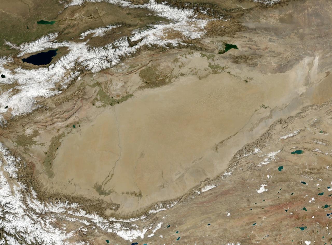
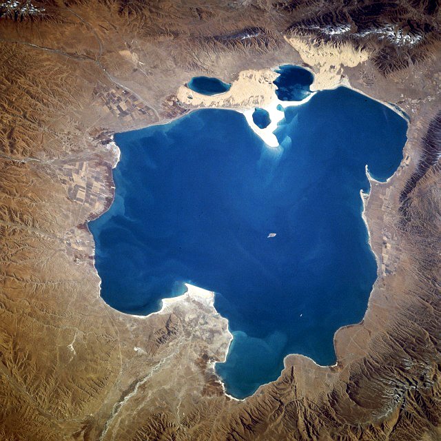
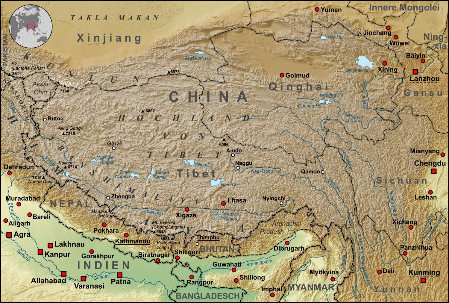
| | | | Anyway, here we are in Xining (no attribution). What? You can't tell? Neither can I. Some stations on the line did have the name Romanized, but for others, you just had to judge that you were there because it was the time you were supposed to be there—although we weren't given a timetable, either! But I've since checked, and 西宁 are indeed the characters for Xi and Ning. "Xi", is of course, our word for "west", and you'll note that its character, 西, looks like a Greek pi (π) climbing out of a box. "Ning" is a bit disconcerting. Its character, 宁, which looks like a guy sitting on a barstool, means "peace" so that Xining means Western Peace. But Xi'an, written 西安, also means Western Peace, so "an", 安, seems to be a different kind of peace than "ning". Aside from the other Chinese writing on the sign, what languages to you see in the middle? | | | | Well, China still uses the vertical Mongolian script, so that would be next, and Tibetan writing has those tails hanging below, as at the bottom, and anyway, those are the two other ethnic groups in the region. Let's take a look at the platform at Xining Station (Photo by B_cool), which dates from 1959, when the line was extended from Lanzhou. Xining is the capital of Qinghai province, and is the largest city on the Qinghai-Tibet Plateau. For over 2000 years it was a commercial hub of the Hexi Corridor of the Northern Silk Road, both of which we'll discuss along with Xi'an later. You'll recognize the Tibet train on the left by its livery—which, of course, is the purpose of having a special livery. And look at the sign. If you see pi climbing out of a box plus a guy sitting on a barstool--and it seems to be the scheduled time to be here--you can be pretty sure it's Xining. | | | | Shortly after we left Xining, I called together a couple of the guys and we took a look at Qinghai Lake (Photo by Yolky) as we passed for quite some time along its north shore (see Tibet train map). I'd read that it's the largest lake in China, and its name translates as "Blue Lake". It was obvious at the time that the lake was important enough so that huge Qinghai Province was named after it, which we can now translate as Blue Lake Province. It was a pretty view, and a nice change of pace. But "pretty view" was about the end of it. | | | | I'm glad I did post-trip research on it, because that opened up a world of information. It's a lake of cultural importance, since Tibetan Buddhist pilgrims walk entirely around it on certain religious occasions, which takes 2-3 weeks. (!!!) I see now that, even though we had barely passed Xining, we had already gained altitude, since the lake lies at 3,205 m (10,515 ft), but in a depression of the Tibetan Plateau. It's classified as a salt lake / saline lake, with a strong concentration of salts, particularly sodium chloride (table salt). It's classified as an alkaline lake, so it has a strong ability to neutralize acids, such as from acid rain or wastewater. And it's classified as an endorheic lake, and that basin it's in is an endorheic basin. Endo-what? A trip to the dictionary explained that, and opened up a whole aspect of geography I'd never really thought much about. It explained endorheic (en.duh.REE.ik) and also brought me to the opposite word, exorheic (ek.suh.REE.ik), both based on the Greek root ῥεῖν, rheîn, "to flow"—and you can see a related place-name there. So the words mean "flowing inward" and "flowing outward", respectively. And the concept is very simple. | | | | Picture an asphalted parking after a heavy rainstorm. Much of the water has run off the asphalt to surrounding areas or to storm sewers. This is the exorheic (flowing outward, away) area. But there might be some depressions in the asphalt (endorheic basins) where the water can't escape, and forms puddles (endorheic lakes), where water flows in and can't get out. The only way for these puddles to disappear is through evaporation, or seepage into the ground via cracks in the pavement, both of which are slow processes. That's the microcosm (tiny version), so let's extend it to the macrocosm (huge version). Check out this map I find very exciting, of the Major Drainage Basins of the World (Map by Citynoise). | | | | Most of the water on Earth drains into the oceans, so most of these huge drainage basins are exorheic. It's interesting to see just what water goes where. Since the adjective "mediterranean" means "in the middle of land", or "midland", three of them are shown: the traditional Mediterranean is called here the Eurafrican Mediterranean Sea, the Gulf of Mexico/Caribbean is the American Mediterranean Sea, both branches of the Atlantic, and the waters between Australia and Asia is the Australasian Mediterranean Sea, part of the Pacific. | | | | But it's the black areas that are the really interesting ones. These are the endorheic basins, which can also be called closed basins, terminal basins, or internal drainage systems, where there's no runoff, and where "puddles" can form in the "parking lot", where the water can leave naturally only through evaporation or seepage into the ground. Because of their nature, the bottom of such a basin is typically occupied by a salt lake. Most of these basins are relatively high up, but some are below sea level—and we recently discussed two of these. | | | | Look at the black area in the US, which is the Great Basin. In its upper part is the Great Salt Lake, and in the south is Death Valley, just discussed in the last posting, where Badwater Basin (Photo by Scottthezombie) is the lowest point. The other endorheic basin below sea level that we discussed, the lowest on Earth, is the ecological disaster of the Dead Sea (Gif map by Hoshana), whose shrinkage in the last half-century can be observed here, including the mining of salt at the salt pans at its south end. | | | | But by far the largest area of endorheic basins is in Central Asia, where the lake called the Caspian Sea can be seen even on the world map. But now let's move closer to the Tibetan Plateau, where we'll look at three more. We had talked earlier about the desert located in the Tarim Basin to the NW of the Tibetan Plateau, where the Silk Road had to split to go around it. The Tarim River (Map by Kmusser) has no place to go except into the lake known as Lop Nur, which is now dried up. | | | | And so we come back to Qinghai Lake, in its own small drainage basin on the Plateau itself. (North here is on the LEFT!) The train passed close to, but not along, that north shore with nice views, although we couldn't see those huge salt deposits visible here. Today, 23 rivers and streams flow into it, most of them seasonal—but NONE flow out. Five permanent streams supply 80% of the total influx. But the lake has been shrinking for much of the 20C, though increasing since 2004. Up until mid-century, there were 103 freshwater rivers flowing into the lake. The lake level continues to drop. | | | | But we said there's a third basin worth mentioning, and shortly after the lake, the train entered the Qaidam Basin (Photo by Gruschke). The picture shows a typical desert steppe landscape on the northern edge of the Qaidam Basin, one fourth of which is covered by some 27 saline lakes. About one-third of the Basin is desert. The Qaidam Basin forms sort of a shelf on the northeast side of the Plateau. This excellent German map of Tibet (Map by Lencer) shows just where this Basin is. | | | | | | But first, some comments on this physical map. Click to see that Shigatse is here spelled in the official pinyin transcription as Xigaze. You can see how a potential rail extension from there to Patna in India might work, which wouldn't be that far from Mount Everest. From left to right, find the sources of the Indus, Ganges, Brahmaputra, and Mekong in the Himalayas, flowing south. On the right, find the Yalong and follow it to where its name changes to Yangzi (German spelling Jangtse), which means that the Yangzi starts in the Tanggula mountains, where we're going. Near Golmud find the Huang He, which you might remember is the Yellow River. Quite formidable as to rivers, here. You can also estimate the route of the possible Golmud-Chengdu rail extension.
You can see that what English calls the Tibetan Plateau, agreeing with the French version, Plateau tibétain, German calls the Hochland von Tibet, or Tibet Highland(s). However, English does use that phraseology when talking about the Scottish Highlands, which in German is the Hochland von Schottland (or Schottisches Hochland). French takes the sneaky way out and in Scotland refers to "Les Highlands".
|
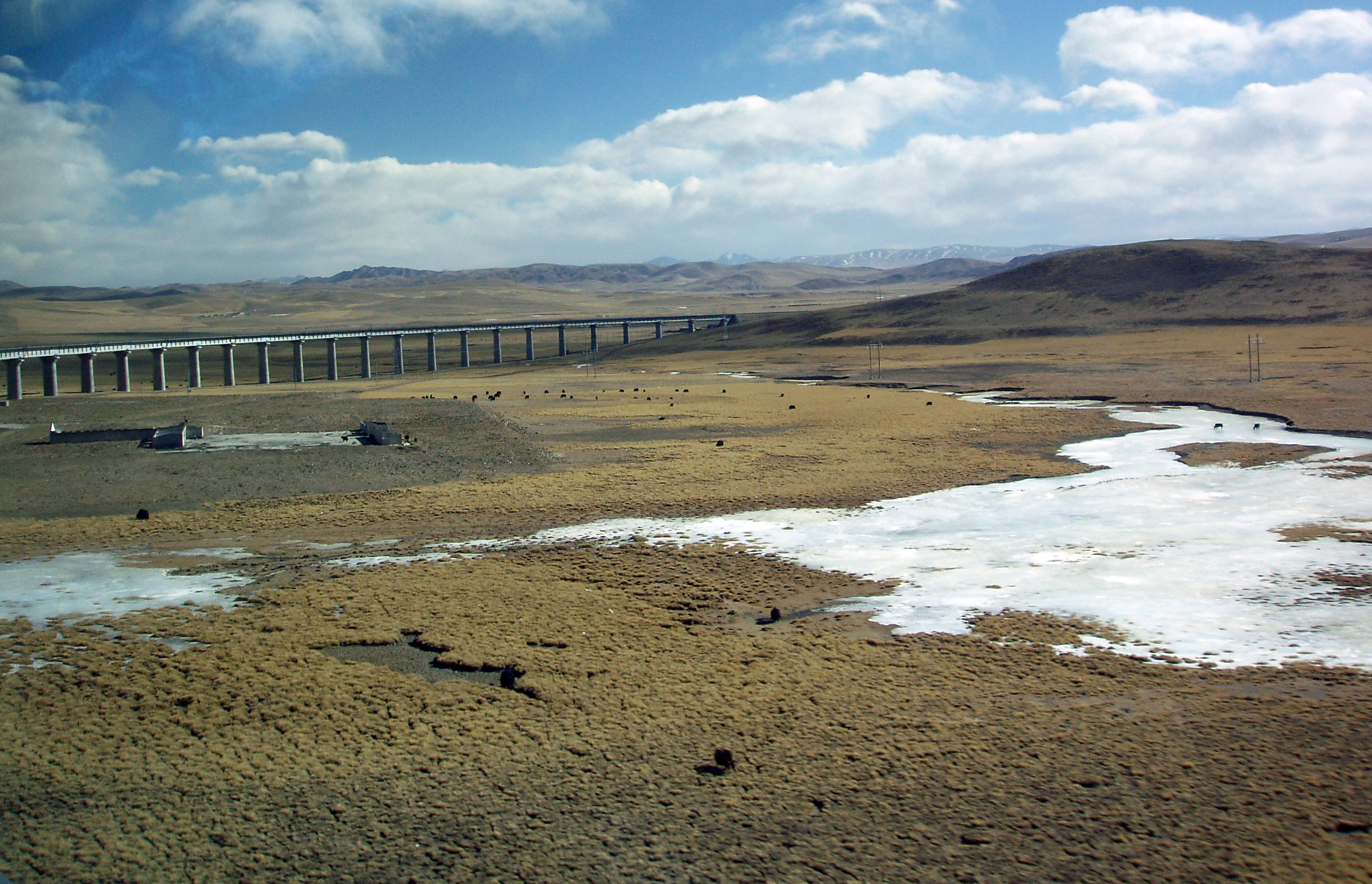
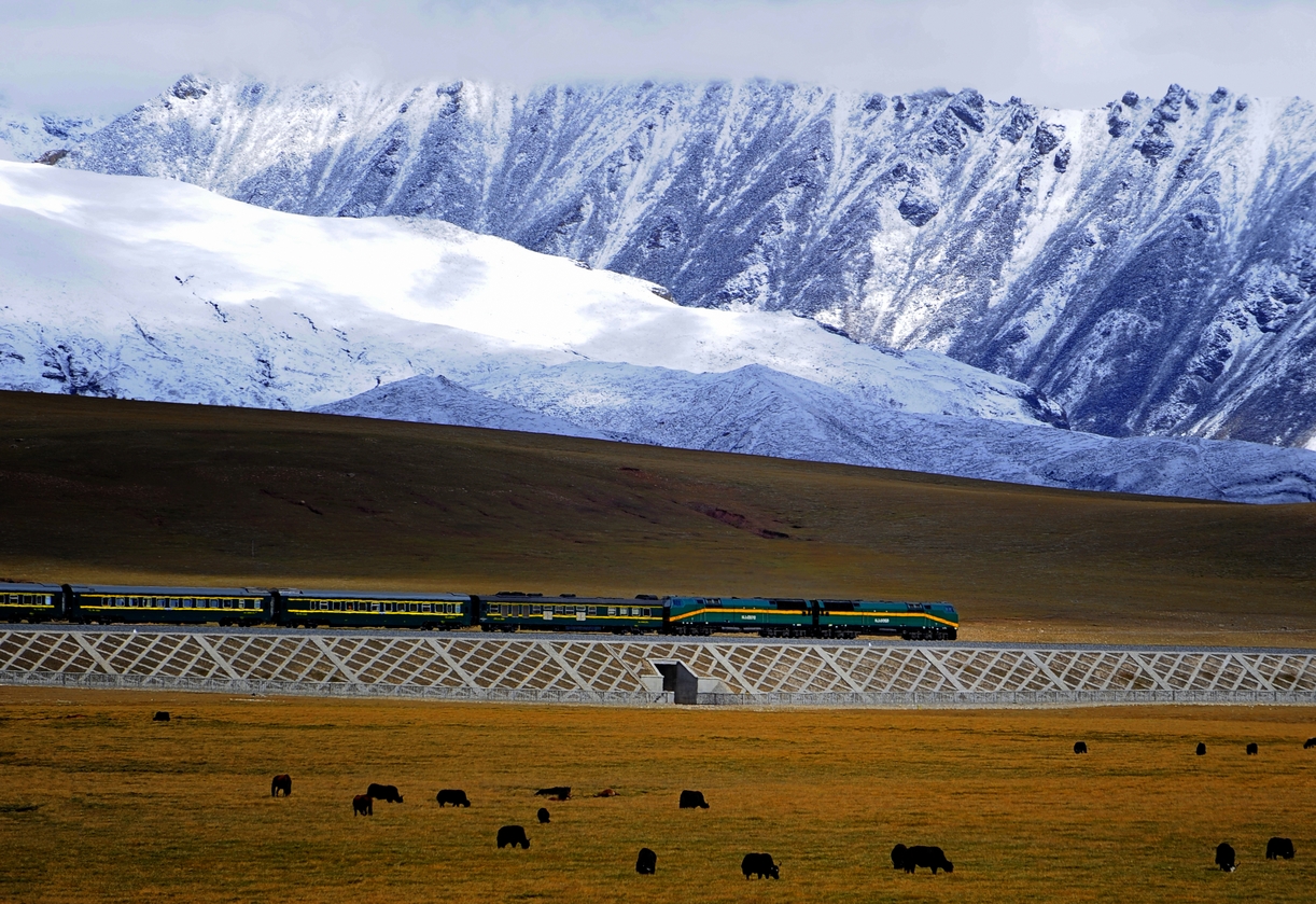
| | | | Back to the three endorheic basins. You can't miss the vast Tarim Basin containing the Takla Makan Desert. Near Xining you also can't miss the Qinghai Hu (Hu=Lake) in its self-contained basin. And now move west, as the train does, into the oval Qaidam Basin, on the way to Golmud. The Qaidam Basin's watershed is separate from the watershed of Qinghai Lake,. | | | | To further understand the geography, picture the Plateau at roughly 4,000 m (14,000 ft), then the shelf of the Qaidam Basin north of it at about 3,000 m (10,000 ft), then the long, narrow Hexi Corridor in long, narrow Gansu Province, the route of the former Silk Road, at about 900-1200 m (3,000-4,000 ft), including Lanzhou. You'll then see how the train gradually has to rise via this basin in the lower part of the Plateau to the highlands, which it reaches at the Kunlun Mountains. You'll also understand why the Silk Road went where it did, keeping to the lower altitudes. | | | | That map located our train route as to physical geography. Let's take one more look at this map to see where we are as to political borders (Map by Ran), which includes Tibetan prefectures as well as two that are mixed ethnically, one large one being the Haixi Mongol & Tibetan Autonomous Prefecture, which is split into two sections, following where the Mongols are. First note some names resulting from the importance of Qinghai Lake. The train went north of the lake through the Haibei TAP—Lake+North, or perhaps Northlake Prefecture. South is Hainan TAP, or Southlake Prefecture, And the large mixed one does the same thing, since Haixi is the Westlake Prefecture. Now: Qaidam Basin occupies a large part of the Haixi Prefecture on the way to the mountains after Golmud. And all this self-enlightenment about the trip, both at and after the lake, is all because post-trip I decided to look up the word "endorheic". | | | | Knowing now what the physical geography is before Golmud, you may understand why the route map just shows it as a dashed line. But it has its attractions. This is a river in the Kunrun Mountains (Photo by Nick Kent-Basham) on the southern edge of the Basin and northern edge of the higher Plateau, as seen from the highway. This is a railway viaduct (Photo by Fanghong) over the permafrost, and those are apparently yaks in the field, which we did see all along the way. Along with the black yaks we saw white sheep. We saw grasslands, and we did start seeing snow-covered fields as we got higher toward Golmud, and occasional, but rare, snow flurries, toward the end of the day. | | | | During the second night on the train I knew we'd be stopping at Golmud, also called Ge'ermu, the second largest city in Qinghai and the third largest on the Tibetan Plateau after Xining and Lhasa. As at other larger stations, we'd have a 20-minute layover, leaving at 01:58, which was technically the 3rd Day of the train ride. We were all asleep, but I could tell we were stopping, and I peeked out the window at the empty platform. | | | | I had an urge that I wanted to set foot in Golmud, so I slipped out of the compartment and got off the train. This was not difficult, since I was wearing my short pants anyway. I've since learned that they empty the wastewater from the train at Golmud, and I might have seen a few workers doing something like that. It was so quiet on the platform, and I was setting foot on the Tibetan Plateau for the first time. Actually, it was the only time I was off the train since Beijing, and wouldn't get off again until arrival at Lhasa. I saw the Golmud/Ge'ermu sign (no attribution) in the dark—this picture has some daylight—and it had the Romanized name as well, something there was more of from here on in. You can see the altitude is already up to 2,829 m (9,281 ft). It was chilly on the platform and I reboarded the train, but I'm very glad I stopped off. It being the middle of the night added to the charm of the short visit. | | | | In the morning it was not only the 3rd day on the train, but Day 3 of the extension. We kept on going higher and higher, and my ears were popping regularly as the area became more mountainous after Golmud (Photo by Michel Royon). However, as I've said before, we had little blue sky as seen in many of these online pictures. Our views tended to have a darker, grayer motif like this (Photo by Michel Royon).
| | | | Go back to the route map you're keeping in another window, as it now needs more explanation. Remember this is an area of low population, so the many stations you see are misleading. Perhaps the local train makes more stops, but after Golmud, our train had only one more stop before Lhasa, at Naqu. The legend on the map says that the stations in white are unstaffed. I'm sure they're not, as that's no surprise. It says the stations in green have viewing platforms. Perhaps, but most are probably unstaffed as well. The stations in yellow are "ordinary". Perhaps there's a bit of a tiny village there, or more likely, at a distance, but not much else. | | | | I didn't have a nice route map like this at the time, so I was "flying by the seat of my pants". I really wanted to see the Tanggula Station as being the highest in the world, but the train didn't stop there, so even if I'd had a schedule it wouldn't have helped. I also didn't know when we'd go over the nearby Tanggula Pass. I kept on looking out the window periodically, hoping I'd see the station, as my landmark for its own sake, and to judge when we'd go over the pass, which isn't always easy to judge. And I was amazingly lucky. I just happened to look out at the right time, and got a quick look at the rather unique-looking Tanggula Station building (no attribution). You can see that this online picture had to be taken from the train. And right after the building I definitely saw the Tanggula Station sign, could read the Romanized name, and could read the altitude notation of 5,068 m (16,627 ft). I'd made it! I might add that the grayness of this view was typical.
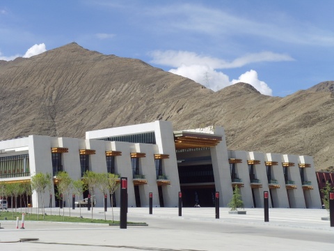
| | | | It IS a station, but, like many of the other unstaffed stations, it's unusual. Although there is a Tanggula Town not too far away, with a 2006 population of 1,286, otherwise the region is virtually uninhabited. There is no passenger service at this station, which is essentially only a passing point for trains. A through train may stop at the station to wait for a train coming in the opposite direction to pass, but no one can get off the train. (!!!) I've also read that the location of the station was specially chosen for the view from the platform—as were those other stations in green—but what good is that? Still, it's the highest station in the world. | | | | This darkish picture shows the Tanggula Mountains (Photo by Jaryiah Khan), with the railway visible in the lower left. It's a moody picture, but artistic in its own way. I like to envision it as an arty travel poster. From Tanggula Station, it's about one kilometer to Tanggula Pass, and the highest point of rail track in the world at 5,072 m (16,640 ft). The pass is shared by the highway, which is a little higher. This freezing visitor is standing at the highway marker at the pass showing the road's highest point at 5,231 m (17,162 ft). The Tanggula Mountains divide the exorheic watershed to the north flowing, as we saw on that map, to the sea via the Yangzi River, from the endorheic watershed to the south to a zone of basins with internal drainage. I have no details about these. | | | | At 11:24 we were at Naqu (Q=CH; the name can also can add a G, appearing as both Nagqu and Nagchu). This is Naqu Railway Station (Photo by Nao Iizuka) with our recognizable livery, and here is the Naqu sign (Photo by Einar Fredriksen), also with a Romanized version. You will note, though, that, while we're still high, we're getting lower, at 4,513 m (14,806 ft), and Lhasa is lower still. | | | | The remaining route to Lhasa went through the Nyenchen Tanglha mountains (Photo by Yoshi Canopus), as viewed here from the train. Just south of these mountains is Yangbajain (see route map), described as lying in an upland lush green valley (Photo by Mckaysavage) surrounded by the tents of nomads, which I did not see, and with grazing yak and sheep, which I did. From this area, the train (Photo by Jan Reurink) continued on to nearby Lhasa. | | | | The train pulled into Lhasa Station (Photo by Naus) at 16:00 (4 PM). The seven of us detrained with the masses and, wondering where our guide was, went into the architecturally interesting and unique Lhasa Station building (Photo by Elume). Still on our own, we went to the main entry/exit in the center there, looking out onto that large empty plaza, to check to see if we could find our guide outside. It was trying to exit from here, with all of us concerned about our guide, that the director showed our Tibet Certificate to the official at the door, but was asked for a copy. One of the guys surrendered his copy to the cause—it certainly wasn't me, after my trouble in getting one—and we went outside. | | | | Look again at the size of that large plaza (Photo by Coolmanjackey) outside the station. It's empty in the picture, and it was empty at the time. Where were all the people who'd wanted to meet the train, including our guide? Well, there was a fence around that plaza and everyone was forced to wait behind that fence, out near the road. China is China, and this was Tibet. So we crossed the plaza, and sure enough, there was our guide waiting for us, and waving to us, from outside the fence. | | | | Tibet Train Videos I first have a longish YouTube video, which is a National Geographic documentary, but from Britain. At 44:58, it's much longer than I usually include in a posting, as it's apparently a TV program. While the first part does show the train, it's only from Beijing to Golmud, where the visiting engineer gets off to see how engineering problems were solved. The bulk of the video explains the huge problem of permafrost, and what was done about it; also the problem of lack of oxygen. I suggest only those with deeper interest in the subject watch the whole thing, while others just skip to the following highlights I want to show. On the other hand, the closed captioning is so faulty, so rife with gross errors, and so hilarious for a serious documentary, that it might be worth watching just for a few laughs ("calamities" for "kilometers", "lesser" for "Lhasa", "matter home" for "Matterhorn"). Perhaps the caption writer could have used a whiff of oxygen or two as well. | | | | Comments on this video: I do not know how the people in the dining car are eating so well, given the dining car problems our group had. Also note that almost anything they show that they keep on calling a bridge is without a doubt a viaduct. If you skim, look for these highlights:
6:05 – oxygen outlet in corridor
9:49 – (unfortunately very short) boy in gold shirt and red hat prostrating himself; once he falls, you see his Mickey Mouse backpack! More on this later
33:17 – Fenghuoshan Tunnel shown and described
33:36 – Tanggula Station, the highest in the world, shown and described
38:05 – triple sink at end of corridor shown
| | | | On the other hand, we have this shorter video (4:22) that shows exterior views exclusively of passenger and freight trains on the Tibet line. But note that it's the return trip, starting at Lhasa Station. Note throughout the high, rocky embankments used because of permafrost that are so fully described in the previous video. Note the many viaducts, and see if you find any structures you'd actually consider a bridge. | | | | Highest Railways in the World There are 19 non-cable railways in the world whose highest point is at over 2,000 m (6,569 ft). On finding the list, I discovered I've ridden on about half of them, 10 out of the 19, the ones below in boldface. Of those, one is Tibetan, one German, three American, and five Swiss. THIS LIST IS UPDATED IN 2015/16. The sequence of each entry is:
RANK; COUNTRY; OPENING YEAR; LINE; HIGH POINT; ALTITUDE:
1) Tibet (China); 2006; Xining-Golmud-Lhasa; Tanggula Pass; 5,068m (16,627 ft)
2) Peruvian train out of Lima; 3) Bolivian train to Potosí; 4) Peruvian train Cuzco-Lake Titicaca
5) USA; 1891; Manitou & Pikes Peak RW; Pikes Peak Summit; 4,301 m (14,111 ft)
6) Argentina-Chile train across the Andes
7) Switzerland; 1912; Jungfraubahn; Jungfraujoch; 3,454 m (11,332 ft)
8) Switzerland; 1898; Gornergratbahn; Gornergrat (at Matterhorn); 3,090 m (10,138 ft)
9) USA; 1881; Cumbres & Toltec Scenic RR; Cumbres Pass (CO); 3,054 m (10,020 ft)
10) USA; 1881; Durango & Silverton RR; Silverton (CO); 2,837 m (9,308 ft)
11) Germany; 1930; Bavarian Zugspitze RW; Schneefernerhaus; 2,650 m (8,694 ft)
12) RW in Taiwan; 13) Tramway du Mont-Blanc, France; 14) Darjeeling Himalayan RW, India
15) Switzerland; 1909; Bernina RW (Bernina Express); Ospizio Bernina; 2,253 m (7,392 ft)
16) RW in India; 17) RW in India
18) Switzerland; 1889; Pilatus RW; Mount Pilatus; 2,073 m (6,801 ft)
19) Switzerland; 1926; Matterhorn Gotthard Bahn (Glacier Express); Oberalp Pass; 2,043 m (6,703 ft)
| | | | I also find that riding the Tibet train resulted in a trifecta for me: the highest railway I've ever been on, the highest location I've ever visited on a day trip, Tanggula Pass, and the highest location I've spent the night at, Lhasa. | | | |
| |
|
|
|

