|
Reflections 2014
Series 10
July 17
China XVIII: Tibet III: Tibet vs China in History – Lhasa
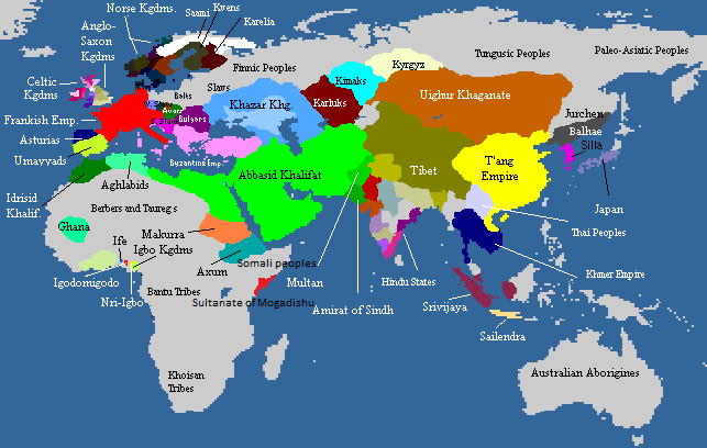
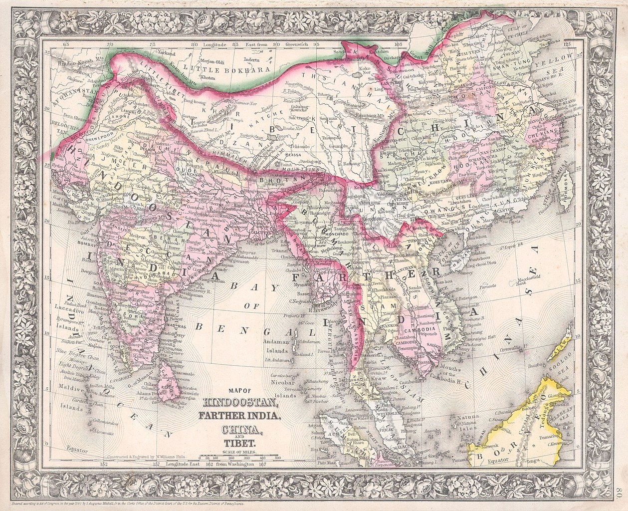
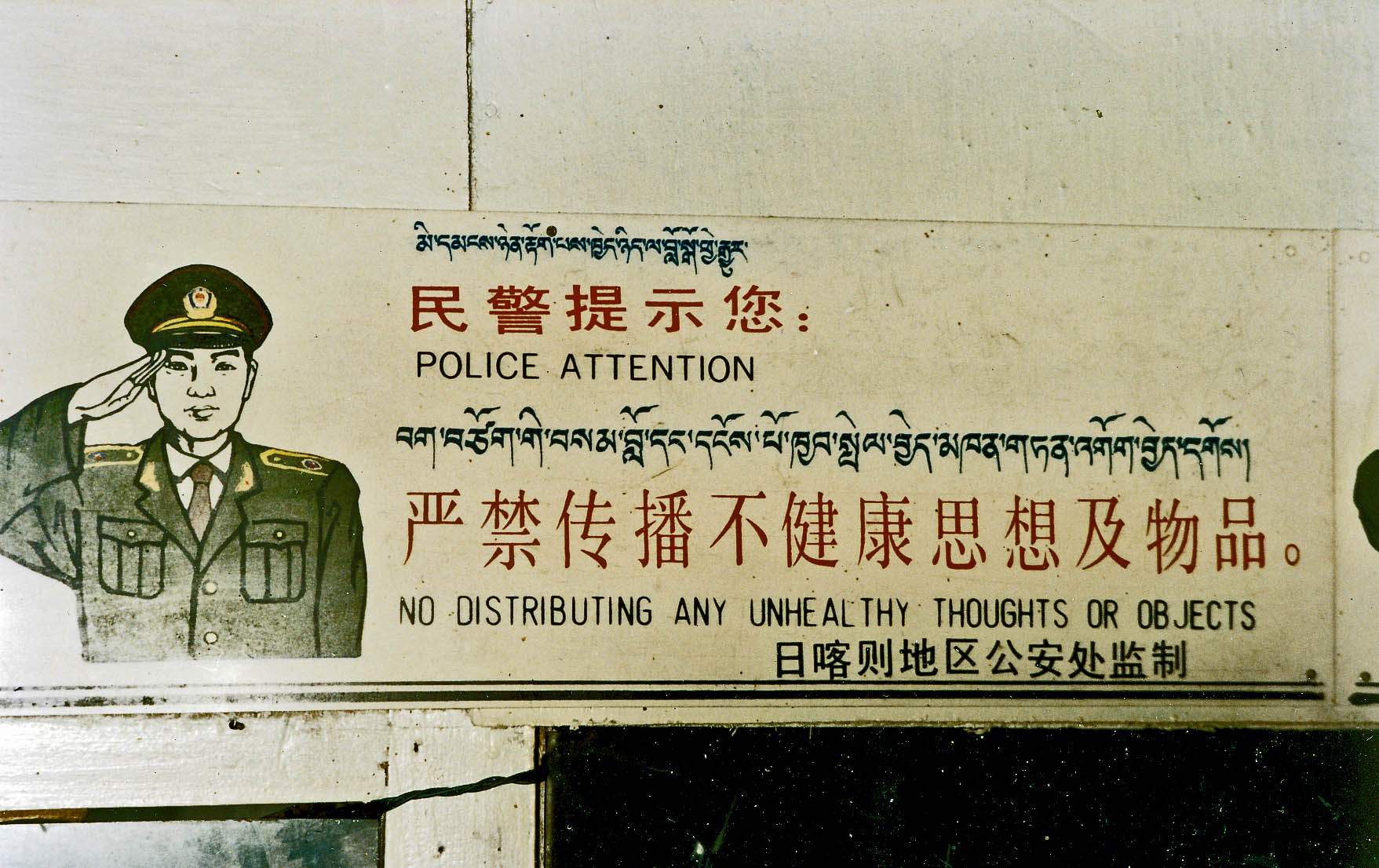
| | Tibet vs China in History We're about to talk about the Lhasa visit, but it's occurred to me that I never fully understood Tibet's claim to independence, so I looked up some maps, plus a summary of the last hundred years of relations between Tibet and China. | | | | We saw in 2014/8 a map of the Tibetan Empire at its greatest extent, in the 780s and 790s, but I also like this larger-scale map showing empires in all of Afro-Eurasia in 820 (Map by Carlaude). Standing out in red is Charlemagne's empire, and we've talked about Norse kingdoms and kingdoms of the British Isles. But look at the size of Tibet in contrast to Tang-Dynasty China. At that time, China stretched out to what today is the Uyghur AR, but then, the Uyghur Empire itself seems to have been further north. But notice the narrow strip connecting the bulk of China with this western area. This is today's Gansu province, with the Hexi Corridor, through which the Silk Road squeezed between the Tibet Plateau and mountains to the north. But in any case, Tibet is clearly a major player on the map. | | | | To illustrate the 19C, we have an 1864 map (click) that includes Tibet and China. Here, China no longer stretches to the far west, and Tibet still includes much of the territory that today is still ethnic Tibetan, including what is today Qinghai Province—you can see that it includes Qinghai Lake, in its alternate Mongolian name, Koko Nor. But less than three decades later, this 1892 map shows Tibet incorporated into Qing Dynasty China. Curiously, the Uyghur area is called here Eastern Turkestan, one of the names many Uyghurs want to use should they achieve independence. | | | | But what I never fully understood is what happened between Tibet and China within, say, the last hundred years, which was this: after the fall of the Qing Dynasty, the then Dalai Lama returned to Tibet from India in July 1912 and expelled all Chinese troops. Then, for the next 3 ½ decades, 1913 to 1949, while China went through the turmoil of its early 20C history, including civil war and WWII, Tibet, lying remotely apart, enjoyed de facto independence. There is a feeling in China that Tibet was still part of China in this period, and Tibet had only very limited contacts with the rest of the world, and very few governments had anything like normal diplomatic relations with Tibet. In 1932, Tibet tried to seize ethnic Tibetan territory in Qinghai Province, and to the east, in what is today Sichuan Province, but was defeated. | | | | In 1949, noting that the Chinese Communists were about to come into power, Tibet expelled all Chinese connected with the Chinese government, but after that, Mao's government asserted a new Chinese presence in Tibet, and by 1951, China's sovereignty in Tibet was formalized, and some Tibetan territory was incorporated then into western Sichuan Province. | | | | The Communists abolished slavery and serfdom. They built running water and electrical systems in Lhasa. They also claim to have reduced taxes, unemployment, and begging. Tibet had had more than 6,000 monasteries, and, between 1959 and 1961, most of them were destroyed, with only a handful of the religiously or culturally most important ones remaining without major damage. Monastic properties were broken up and secular schools were established, breaking the educational monopoly of the monasteries. Thousands of Buddhist monks and nuns were killed, tortured, or imprisoned. | | | | I found online this picture of a trilingual sign (Photo by John Hill) above the entrance to a small café in Tibet in 1993, which imparts Big Brother atmosphere. However, I saw nothing like this when I was there. | | | | There have been several recent periods of emigration from Tibet, resulting in what people have called the Tibetan diaspora. One was in 1959, following the Dalai Lama's self-exile to India. Another was in the 1980's, when Tibet was opened to trade and tourism. A third started in 1996 and continues to today. Some parents send their children to communities in the diaspora to receive a traditional Tibetan education. Most Tibetans living in exile live in adjacent India, Nepal, and Bhutan. The estimate of Tibetans in exile varies between 128,000 and 150,000. | | | | Lhasa The literal meaning of Lhasa is "place of the gods" indicating that it's a religious center as well as the capital of Tibet. It's the second most populous city on the Plateau after Xining. Its altitude of 3,490 m (11,450 ft) would be more significant on arrival if you didn't realize you'd just come down from Tanggula Pass earlier in the day at 5,072 m (16,640 ft).
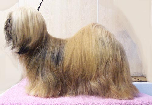
| | | | Lhasa is located on a flat plain at the bottom of a small basin surrounded by the Himalaya Mountains. I didn't fully realize that at the time, since I thought the Himalayas were only further south near Everest. Do not be put off by the odd coloring of the this picture, which is a false-color image, used to ease detection of features you couldn't see well otherwise. Everything showing up in shades of red is in actuality shades of lush green, and everything in shades of blue-gray are buildings. The lush green indicates that Lhasa is an oasis. | | | | These mountains surrounding the city, appearing as two parallel ridges, rise to 5,500 m (18,000 ft), which is higher than Tanggula Pass. Lhasa's location in this basin protects it from intense cold, heat, and strong winds. You can see how the Lhasa River winds through the valley on the south side of the city. The fact that it winds and meanders so much and breaks up into channels proves that the ground is relatively flat. | | | | Very noticeable on the north side of the city is the Lhalu Wetland Nature Reserve, which appears as a deep red-brown with black areas indicating water. This influences Lhasa's climate, adding humidity to the city. The plants are also an important source of oxygen in the low-oxygen air at this altitude, which contains only 68% of the oxygen of air at sea level. | | | | Click on the downtown area with two white dots. The larger dot on the right is the fortress-like Potala Palace complex, former winter home to the Dalai Lama, sitting on a small natural hill. The one on the left is the Dalai Lama's former summer place, Norbulingka, surrounded by a large park. We next have a ground-level, yet still high, view of the Potala Palace (Photo by Qeqertaq) and the valley floor. The green of the mountains and valley shows up properly in this true-color image. Let the height of the mountains contrasting with the valley impress you. Click on the Potala to get an early view of the red and white palaces within it. Notice the many high, steep staircases leading up to the Potala. | | | | Before we get back to the narrative of our visit to the city, I want to add a point about dogs. I bring up the subject when it's appropriate, as in Canada, talking about the Labrador and Newfoundland dogs and in China talking about the Pekingese. But I have to admit that I'd never put two and two together, obvious as it may be now, that Lhasa is the home of the Lhasa Apso (Photo by Elminjas). It was bred as a household sentinel for Tibetan nobility and in the Buddhist monasteries to warn of intruders. The most likely explanation of the name is that apso in Tibetan means "bearded", indicating that the dog is long-haired. But in the monasteries, it was the interior sentinel, whose keen hearing and sharp bark served as a burglar alarm, just in case an intruder got past the entrance. So who guarded the entrance? It was the large Tibetan mastiff (Photo by Mimayin), whose Tibetan name, dok-khyi, can translate as "door guard". It not only guarded monasteries and palaces, it was a guardian of herds, flocks, tents, and villages. But its name is a misnomer, since it isn't a mastiff, a word that Western visitors used simply because it's a big dog. A better name would be Himalayan Mountain Dog. | | | | Lhasa Visit We ended our narrative in the last posting at the end of Day 3 crossing the empty plaza outside Lhasa Station to where spectators were confined behind a fence at the road. Our guide was waiting for us there, and we accompanied her down along the fence to the parking lot where our van was waiting. She introduced herself to us using the Western name May. She said she was Tibetan, and at one point some time later I said I was glad it was an ethnic Tibetan taking us around, and she said she was glad, too. She pointed out that the van driver was Chinese, and, as I said earlier, his situation was typical, as he lived somewhere in China and drove his van to Tibet to do this work during the season, returning home afterwards. This of course draws money out of Tibet. | | | | This is a rather good map of Lhasa. Copy and paste the link in another window for continued reference during this posting. You definitely should click to enlarge it:
http://www.beijingholiday.com/assets/images/new-bjh/lhasa/lhasa-map/lhasa-city-map-full.jpg
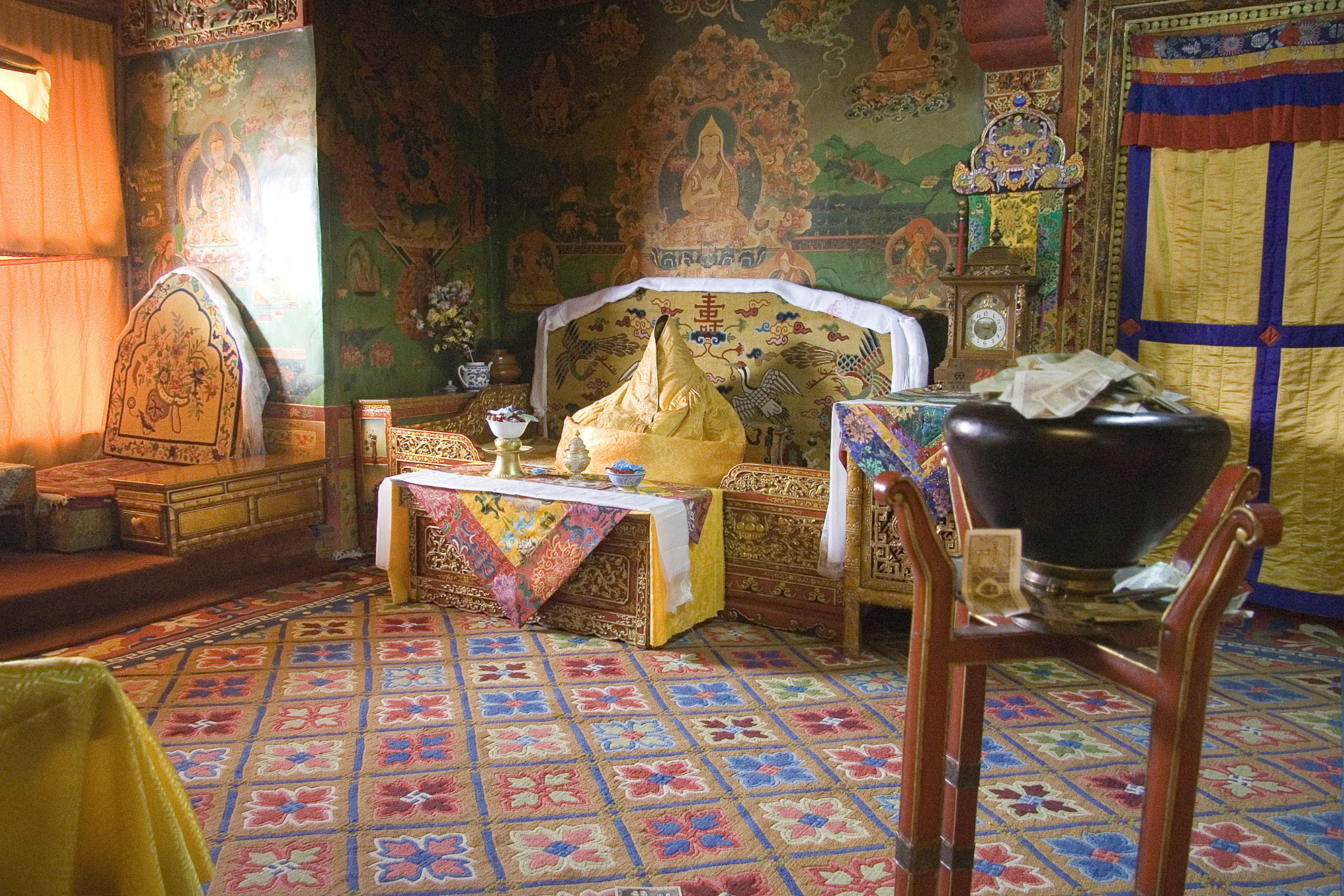
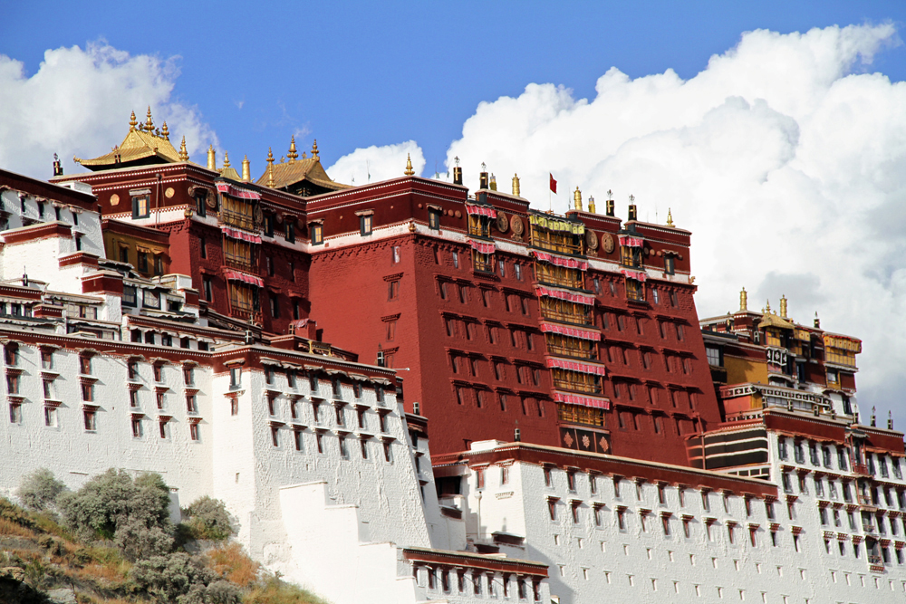
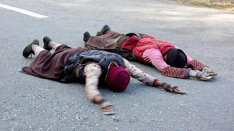
| | | | It's very easy to re-orient yourself in town from the pictures we just saw. You know Norbulingka, the summer palace (detail in the inset on the upper left), and the Potala. Now add the third building of great importance in town, the Jokhang Temple (and Monastery) in the historic Barkhor neighborhood. These three together form one UNESCO World Heritage Site. There are three major monasteries remaining. We had a very interesting visit at the Sera Monastery at the top of the map. We were scheduled to also see the Drepung Monastery to the left, but time was short and one monastery was enough. The third one is much further out of town. You now are fully oriented as to the visit. | | | | But we start with a mystery. Where is Lhasa Station? I know where it is. Google Maps knows where it is (which is why I know—check for yourself). How about everybody else? There's no trace of the station, the streets around it, or the bridge over the river leading to it on this excellent map and others I've checked. Could the reason be military? Who knows? China is China, a station can be considered a military object, and this is Tibet. | | | | We should locate the station. Find Norbulingka again. West of it is Luding Road, which in actuality crosses the Lhasa River over a bridge and meets that Sichuan-Tibet Highway, right to the left of that sharp bend. A right turn (to our left) on a cross road leads, after 3-4 blocks, to the station. It could easily have fit on this map. Why wasn't it put there? | | | | Let's get with May and the driver in the van, cross that bridge, and turn right onto that yellow road. It's late in the afternoon, and so we're just going to settle in to the hotel for the evening. Below the Jokhang we turn right on another yellow road and right into the first white road, Bolinka Lu, and #10 is our hotel, on the left, across from the stadium area. The street is small and quiet. The hotel has a stoop, not perpendicular, but sideways, with steps on both sides. The building is attractive, contemporary with a traditional look, and has windows that seem Tibetan. But it's hard to tell it's a hotel, as it's hardly marked. | | | | I was quite satisfied with this hotel. It wasn't glitzy or flashy, like all the other hotels the travel agent had booked, but quiet and serene. I was surprised when the name of this hotel was announced before we left. It was Four Points by Sheraton Lhasa, which is not the top of the line in the Starwood group. As a matter of fact, Frommer gave it no stars, yet called it one of Lhasa's most luxurious accommodations. Frommer calls it solid, modern, attractive, and says it's hard to find the entrance. And it's true. | | | | We checked in in the rather tiny lobby, and then were directed out the back of the lobby to the cobblestoned courtyard. The restaurant was to the right, and our rooms across the way on the other side. Some of us were on the ground floor, and the director and I had rooms one flight up. I say all this for a good reason. | | | | We had been warned before we left home about altitude sickness. I'd been at high altitudes, so I thought I was impervious to it, but still I did as suggested and asked my doctor for pills. Surprisingly, he told me that he and his wife and another couple had just taken the Tibet train two years earlier. I counted out all the days between Beijing and Xi'an and he gave me pills for that entire period, and I took them daily that whole time. It was acetazolamide, also sold as Diamox. | | | | The pills didn't help. I was fine on the train, but of course, that had pumped-in oxygen. I didn't notice anything in the van, or checking in, but when I had to walk my wheeled bag across that cobblestoned courtyard, I thought the walk would never end. When I reentered the building on the other side, the one flight of stairs seemed formidable, particularly with my bag. But later, I continued to regret that that staircase was there even going down, because of the exertion. In the room there was a oxygen emergency kit, but it wasn't an emergency. | | | | I've since checked up on altitude sickness, which happens when the available amount of oxygen needed to sustain mental and physical alertness is not sufficient. It's described as being similar to having the flu, or a hangover, and I suppose that's so. I've read that headaches are the primary symptom, combined with any number of others in a long list that includes lack of appetite, nausea, vomiting, dizziness, insomnia, shortness of breath, swelling of hands and feet. I had NONE of those symptoms at all, not even the headache. But there were two symptoms in the list that I did have, fatigue, and malaise. These symptoms can be rephrased as "I want to sit down" and "I don't care". | | | | I've since read that people misconstrue the benefit of the Tibet train taking you gradually upwards, not like a plane, where you have a sudden change in atmosphere. The train might have helped if Lhasa were its highest point, but in reality you go up, and then come down again, losing any benefit you may have gained. Beijing and Lanzhou are both too low to help in acclimatization. Xining and Golmud are helpful up to Tanggula Pass, but then Naqu and Lhasa are lower again. At any rate, for my two full days in Lhasa, until I got onto the train again, I slept fine, ate well, but as I was enjoying Lhasa—and I did--it was a constant matter of fatigue and malaise. | | | | The first full day in Lhasa was Day 4 of the extension. I dragged myself down—yes, down—that one flight of stairs and across the courtyard to breakfast, and then May met us with the van. We swung around Jokhang and drove down Beijing Road, a matter that May pointed out specifically. We were in the older part of town and, as she pointed out, it was very Tibetan in style. I noticed the style particularly in window frames, something we saw more later in the palaces. May said the area further west around the summer palace is more Chinese in style. I figured that made sense, since that would be where the city grew during the latter 20C, when China's influence was strong. This picture shows a main street in Lhasa (Photo by Rainer Haessner), Beijing Road or similar. | | | | One thing we noted was the proliferation of religious processions, not formal parades, but just people walking along the sidewalks, very often on set routes, especially surrounding particular buildings such as the Jokhang and Potala. And that's where we were headed, the most famous building in Tibet, the Potala Palace. | | | | The driver dropped us off on the east side, and May bought tickets for us. We went through security, where, to our surprise, we had to also show our passports, and then walked bit in the garden. Then we went through a second security check, and walked a bit further. Then we went through a third security check. China is China, this is Tibet, and this is the Potala. | | | | It was the Fifth Dalai Lama (the present one is the 14th) who started construction on the Potala Palace (Photo by Coolmanjackey) in 1645. The fortress-like structure is composed of two parts, the ● Red Palace (Potrang Marpo) in the center and the ● White Palace (Potrang Karpo) on either side. All the zigzags you see (click) are the many steps leading up the hillside to the complex. | | | | In 1649 he and his government moved into the White Palace (Photo by onwardtibet.org), with its typical Tibetan architecture. We also see the gold-painted courtyard that separates the Red and White Palaces within the Potala complex. The White Palace was used from then on as the winter palace and as the usual living quarters of the Dalai Lama (Photo by Luca Galuzzi - www.galuzzi.it). Click to inspect the folded robe on that wide throne that's meant to represent the present Dalai Lama. The room would seem to represent Tibetan art and decoration quite well. The White Palace also had other secular uses; it was used as a printing house, seminary, and offices. | | | | Between 1690 and 1694 the Red Palace (Photo by René Heise) was added, which is devoted to religious study and prayer. It contains the principal assembly hall and chapels, libraries, shrines, and tombs of eight past Dalai Lamas. | | | | As we saw earlier, the Potala is perched at the top of its steep hill, the Marpo Ri, or Red Hill (red is clearly visible in the picture), right in the middle of Lhasa. The buildings are thirteen stories tall and contain circa 1,000 rooms, 10,000 shrines, and 200,000 statues. The buildings are 117 m (384 ft) high, and are on top of a hill of over 300 m (1,000 ft). A distinctive look is given to the complex by the sloping stone walls all around it, which average a thickness of 3 m (10 ft) at the top and 5 m (16 ft) at the bottom. Only the upper parts of the walls are pierced by straight rows of multiple windows. Copper was poured into the foundations to help protect it from earthquakes. The Potala remained the chief residence of the Dalai Lama until the present one fled to India in 1959, at which point the Potala became a museum. The building was slightly damaged during the uprising in 1959. It escaped damage during the Cultural Revolution in 1966 through the personal intervention of Zhou Enlai. Nevertheless, almost all of its over 100,000 volumes of scriptures, historical documents, and other works of art were either removed, damaged, or destroyed. The Palace is named after a Mount Potalaka ("Brilliance"), which is a mythical dwelling of a Buddhist god in India. The hill is supposedly located in the seas south of India or on a cape at the southern tip of India. | | | | Copy and paste into another window this layout map of the Potala. It's the map I printed out and brought with me on the trip:
http://www.travelchinaguide.com/images/map/tibet/potala-palace.jpg
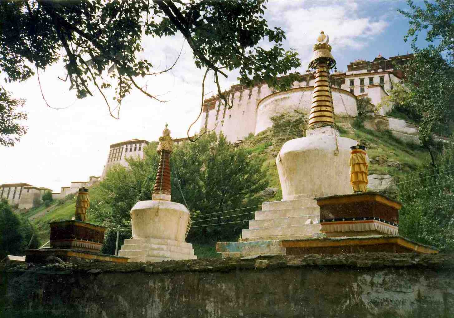
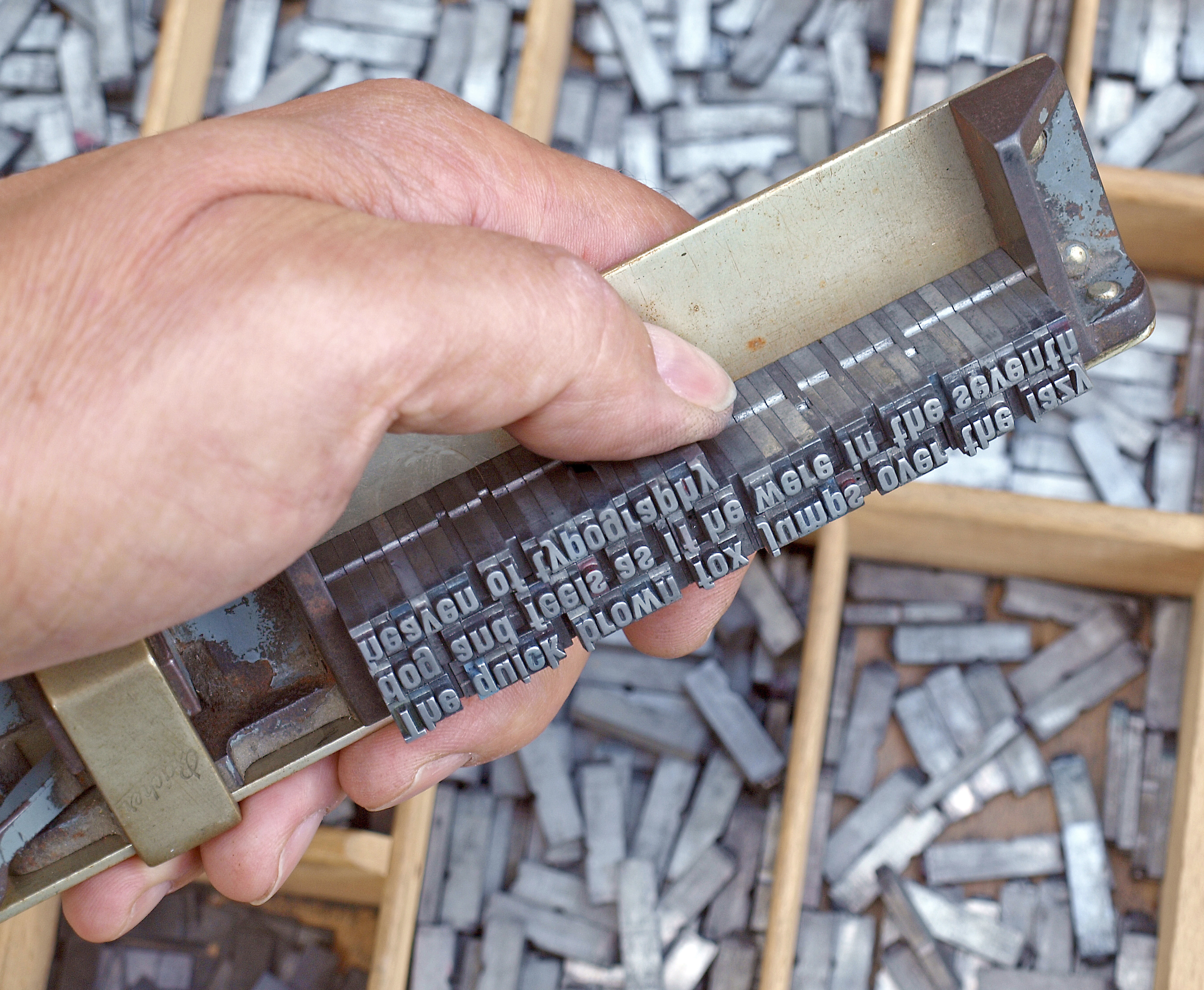
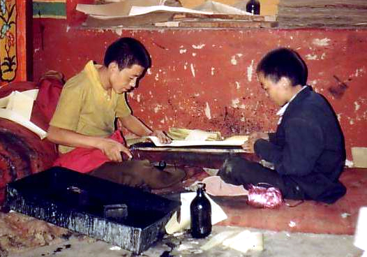
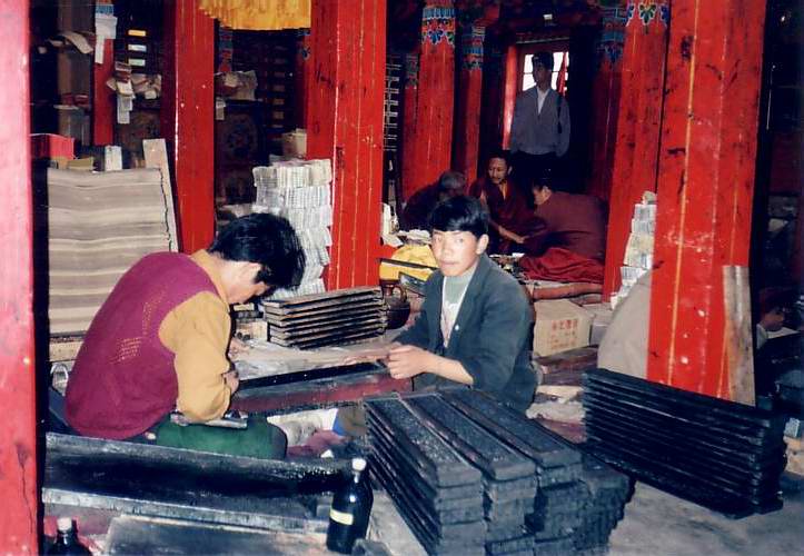
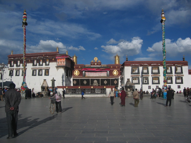
| | | | Those structures at the bottom are all in the garden area. The red zigzags are only a general indication of the many stone steps to be climbed to reach the buildings above. This is another view of the Potala Complex (Photo by Antoine Taveneaux). You see the lower buildings in the garden, and the yellow courtyard above. You also see the metal roofs on the top. But only if you click on either side of that central tree do you see some of those killer steps, and even some people managing to climb them. This is a side view of the Potala (Photo by John Hill) showing the pleasant garden area below. | | | | The number of people allowed to visit the Potala at one time has in recent years come under a quota to avoid overcrowding of the meager space up top. Before the quota, the average number of daily visitors had been 1,500, but sometimes peaked at over 5,000 a day. After the rail line opened in 2006 there was a 30% increase in visitors. The quota had been lower, but has been increased, and is now up to 2,300 visitors a day on a shortened six-hour day, with timed tickets, which are hard to get in peak season. The quota is often reached by mid-morning. | | | | In addition, May told us that guides are told to keep their tours moving, and only one hour is allowed up top. She also said that guides who keep their groups too long are penalized, and aren't allowed to bring any groups for the specific period of the penalty. The most interesting thing I heard was that it's being considered to close off the top area of the Potala entirely to visitors and to substitute a video instead of the interiors and exteriors up top, to be shown down below. | | | | Now you may—or may not—have seen this next point coming. Half our group never made it up top, including me. This is how it came about. We were in the garden, and May was giving us a pep talk about the difficulty of climbing, about trying it slowly, about the visit being restricted up top. She suspected what might happen—it must happen all the time—and specified that anyone who doesn't want to go up top, or anyone who tries, but gives up, should spend time in the garden, including looking at the views of the top, and visit a rather nice art museum in the garden, and meet with her and the others outside after about an hour or so, at the entrance we'd come in on. I had my doubts, but, even with my fatigue and malaise, was determined to try. But just remember, even the single staircase in the hotel was an effort. | | | | One guy didn't try at all. One guy made it up one somewhat lengthy staircase, then turned back. I'm glad to say that I made it up 1 ½ staircases before I felt I couldn't go another step, and turned back. May continued with the other four in the group. | | | | I must say it was daunting. One online comment I read regarding the climb talks about "hiking endless steep stone steps and . . . staircases slick and black with age". Remember, the hill is 300 m (1,000 ft) high, and it seems that the hill realizes it's a junior Himalaya. I think it was easier for Jack to climb the beanstalk to the sky. I found an online comment that there were 1,080 steps, but that is totally unverified. I would say, think about the most steps you've ever climbed at once and then tell yourself you've only started. That's what it felt like, especially at that altitude. | | | | In consolation, while I've visited many palaces and stately homes in Europe and North America, there were many whose interiors I never visited, since you don't have to see each one. As to the Dalai Lama living quarters, we'd soon be seeing others in the Norbulingka, the summer palace. And take a look at this short (0:46) YouTube video of visitors reaching the top of the steps at the Potala, at the White Palace. Listen for the wheezing and heavy breathing as well. But the view is nice. | | | | I went to the art museum and took a stroll around the garden. There were lots of marigolds, and, it being September already, lots of the chrysanthemums I'd seen in Japan at this time of year in 2009. But then I left the complex and sat on a bench in a park area outside that side entrance next to the main road to people-watch. And I saw two things from that bench. | | | | As I said, long religious processions of pilgrims (Photo by Steve Taylor) with hand-held prayer wheels in Tibet are common, and as I sat there, a procession (Photo by Antoine Taveneaux) was passing obviously doing a complete circuit of the entire Potala Complex, possibly multiple times. So be it. But the second thing I saw were prostrations, which require a comment. | | | | Religious prostration is not uncommon. It happens in the Roman Catholic Church, for example, and Tibetan Buddhists do it in front of and inside temples (Photo by Luca Galuzzi - www.galuzzi.it). These pilgrims are doing in front of Jokhang Temple, the most important one in Tibet. But note that most of them are using mats. I'll call this stationary prostration. | | | | But what unnerves me somewhat is what I'll call ambulatory prostration (Photo by Gao), or prostration within a procession. Actually, it's also referred to in the West as kowtowing. Note that these people don't have a mat, but have heavy clothing to protect them, including arm padding. They also have wooden blocks attached to their hands. For every (religiously significant) three steps of their procession, they would fall to the ground, then walk three more steps, then fall again. And they'd circle the entire Potala doing this. And this is a pilgrim near Naqu doing the same on a public highway. Note his heavy leather apron, and hand blocks. If you still have difficulty picturing this, watch this short (0:53) YouTube video of pilgrims on a highway. | | | | Note how many days that pilgrimage is taking for these women. The narrator is admiring what they're doing, but in an editorial comment, I find it an example of bizarre extremism that can appear in all religions. I've seen Catholics on their knees going long distances in Lourdes, Fatima, and Guadalupe. I visited Ultra-Orthodox Jews living in Mea Shearim in Jerusalem, but some of them throw rocks at public buses being operated nearby on Saturdays. And then there are Muslim jihadists. Religion in moderation is one thing. Bizarre extremism in the name of religion is something else. I usually bond with cultures I visit, but I can't with this aspect of Tibetan Buddhism. This came home to me as I sat on that bench and saw a boy of about ten in his leather apron and hand blocks take his three steps then crash to the sidewalk, then repeat it. I couldn't reconcile with that image. | | | | To see a young boy doing this, I refer you back to the previous posting, 2014/9, and, right before the end, to that first, longer video. Watch just 20 seconds of it again. Start the video at 9:32 to see the Potala and then regular street processions. But at 9:49 you see a little boy doing ambulatory prostrations, not only with a leather apron and wood blocks, but also with a Mickey Mouse backpack. It's very short, and ends at 9:52. I find it sad. End of editorial comment. | | | | The three of us met back with the group, and, after lunch in a Tibetan restaurant, drove about 15 minutes north (see Lhasa map) to the Sera Monastery. It's one of the three major university monasteries of Tibet. The other two are the Ganden Monastery, further out of town, and the Drepung Monastery, on our map. In now learn that they were all three founded within a few years of each other. Ganden is the oldest, from 1409. It was completely destroyed in the 1959 uprising, and in 1966 it was severely shelled by Red Guards, and then the remains were dismantled. Rebuilding has been continuous since the 1980s. | | | | The next oldest is Drepung, founded in 1416. It the largest of the three. About 40% of it was destroyed after the Chinese arrived in 1951. Although it had been listed as a stop on our itinerary, when May said we didn't have time, we were all in agreement, since we were monasteried-out after visiting Sera. | | | | Sera is the newest, dating from 1419. The Sera complex of structures includes a Great Assembly Hall and encompasses three collages. It's in the foothills north of Lhasa. As a matter of fact when we were at Sera, May pointed out a hermitage connected to Sera nestled way up above us near the top of those foothills. During the 1959 revolt, Sera suffered severe damage; the colleges were destroyed and hundreds of monks were killed. | | | | I am now surprised to find out, although it's completely understandable, that all three monasteries reestablished themselves in the 1950s as parallel monasteries in a Tibetan settlement in the extreme southwestern part of India on land given to the Tibetan community-in-exile by Nehru. This happened after the Dali Lama took exile in India. The three original locations in Tibet operate under the eyes of Chinese security and have lost much of their independence and spiritual credibility in the eyes of Tibetans. While Sera Lhasa once had 5,000 monks, today it has a few hundred, while Sera India has about 3,000. | | | | Sera was perhaps the most interesting stop for me in Lhasa, yet with my oxygen-deprived lethargy, I had to drag myself out of the van and up the path to walk among its buildings (Photo by Antoine Taveneaux). As visible in the picture, the path was largely uphill, wouldn't you know. Here are some prayer wheels (click) at Sera (Photo by Antoine Taveneaux), and I have in my notes that at one point we saw little kids getting a black mark put on their noses, which would seem to be similar in nature to the black ash marks Roman Catholics get on their foreheads on Ash Wednesday. But it was the quaintness of the buildings (Photo by Antoine Taveneaux) that the uphill path wended through that stays in my mind most strongly about walking around the Sera complex. | | | | We saw the Great Assembly Hall and heard that the three colleges teach all subjects. Many of the areas were temple-like, with many Buddhas, such as this, the Shakyamuni Buddha (Photo by Dennis Jarvis). You MUST click this to properly inspect the artistic detail. | | | | Two things in particular appealed to me at Sera, the ▲ unusual "monk debates" and the ▲ so-called "library". Both Sera in Lhasa and its counterpart in India are known for these monk debates on the teachings of Buddha and Buddhist philosophy, which are an integral part of the learning process in the colleges. It's said this type of debating is unique to Sera. After touring some of the buildings, May took us out into a pleasant, tree-filled, walled-in courtyard, the "Debating Courtyard" of the monastery, where it was debating time (Photo by Luca Galuzzi - www.galuzzi.it) for dozens and dozens of monks. The unusual debating tradition, on a set schedule every day, is supplemented with gestures, as in the picture, and each gesture has a meaning. Presumably the gestures help improve the monks' debating skills, particularly when they clap their hands to prove a point. | | | | It's hard for the spectators gathered around the courtyard against the stone walls to tell what's happening, since it all resembles buskers in the middle of a street performance. I now find out there are precise rules, and a teacher is present to rule when necessary. The defender, apparently the one standing, has to prove his point, and the questioner, seated, has to challenge him with appropriate questions. Intense verbal exchange is common, and the vigorous gestures enliven the proceedings. Clapping is the most obvious of the gestures. Loud clapping occurs after each question, and also when the defender wants to denote his self-assurance and the power of his arguments. This YouTube video of monks debating at Sera runs for 2:17, and gets livlier in the second half. You also have to picture our group lined up under the trees near the courtyard walls. | | | | But I think I found most captivating of all was what May described as the monastery library, but which I'm sorely tempted to call its print shop. (Remember the White Palace also had its printing house, which I now suspect was the same as this.) There might have been some books somewhere in the room on wooden racks, but what really hit the eye on entering is the racks of woodblocks (Photo by Marisburbergs) around the room, woodblocks used for printing, in this case scriptures. They're long and narrow, as can be seen by the one pulled out at the end. Perhaps you can call it a library where books are printed as needed, I don't really know. I immediately I pictured 15C Mainz, with Gutenberg ready to make his move. | | | | A quick recap; in 2005/17 I explained how happy I was in the now long-lamented print shop course at Brooklyn Tech, about how the University we attended in Mainz was the Johannes-Gutenberg Universität, and how Gutenberg had made his contribution to European and world culture in Mainz on or about 1439. Some people are confused about just what his contribution was. One way to print a page of a book is to carve text, also pictures, into a single block of wood. Gutenberg invented movable type, so that each letter was on its own tiny piece of wood, and then the letters were assembled into lines and finally a full page. It was printing by movable type that played a key role in the spread of learning to the masses, and in the development of the Renaissance, Reformation, and Age of Enlightenment, as well as in the scientific revolution. | | | | Later movable type was made of metal, as illustrated by this diagram of a piece of type for a capital H. (The letter on the type always appears in reverse, except you can't tell with a capital H.) Printers using this method would compose lines of type in a composing stick (Photo by Wilhei), shown here with the practice sentence "The quick brown fox . . . " being assembled. The individual pieces of type are in their tiny boxes in the case below. | | | | Using movable type became the printing standard in the West, but here I was in a Tibetan room where woodblock printing still seemed to be the norm. It was a real thrill. (It should be mentioned that May told us that all the woodblocks we were seeing are modern replacements of all the woodblocks destroyed during the Cultural Revolution.) I have since learned that traditional Tibetan books, particularly for scriptures and historical texts, are called pechas, and, unlike most Western books, are long and narrow. The books are loose-leaf, usually with top-and-bottom wooden or cardboard covers, and are often wrapped in cloth for protection. These books are all printed by that alternate printing method of using woodblocks, and therefore, the woodblocks (Photo by Rainer Haessner) are also long and narrow. But why? | | | | It all started in India as early as 500 BCE where, perhaps parallel to the use of papyrus in Egypt for writing, palm leaves from certain specific palm trees were used for writing manuscripts. When wood blocks were eventually used for printing, they also took the shape of long, narrow palm leaves. Pechas trace their history and unique shape back to this. When the technology of writing, and also printing, on palm leaves crossed the Himalayas from India to Tibet around the 7C, there were—surprise!—no palm trees in Tibet, so at first birch bark was used, and eventually paper. Woodblock printing remained the most common book-printing method in East Asia well into the 19C, far longer than in the West, and, as we found out, was still used in Tibetan monasteries today. The only similar technique in the west is the art form known as woodcuts. | | | | Ironically, in the computer age, digital copies of pechas are not uncommon, nor is the software needed to print them. Still, the traditional woodblock method (Photo by John Hill) continues in monasteries, and not by using printing presses, but with the printing done manually! (Photo by John Hill). (I did NOT see this being done.) When printing, monks work in pairs. The first one rubs an inkpad down the woodblock; the second one lays a long blank sheet of paper on the block and presses it down with a roller, then they both remove the paper and lay it aside. This YouTube video (1:27) shows the astounding speed at which woodblock printing is done in Sera Monastery. At the very end (1:11) you see page changing: first the block is flipped to print the page on the back, and then the block is exchanged for another. | | | | Before we left the library-cum-printing house, there was one more very special thing to see in the room. Near the center there were two tables the size of card tables, and each one had a mandala laid out on it. Better yet, each mandala was a sand painting, in other words, it was a sand mandala. | | | | A mandala--with an A, not Nelson Mandela with an E—is a spiritual and ritual symbol within Hinduism and Buddhism. "Mandala" is the Sanskrit word for "circle", and a mandala (Photo by RThiele) thereby represents the Universe. The basic form of most mandalas is a square with four gates containing a circle with a center point. Each gate is in the general shape of a T, so you'll see that this mandala in the picture is typical. Mandalas can be constructed using any media, but in the Tibetan form of Buddhism, mandalas are made as sand paintings. The one in the picture had been constructed at Sera, and you'll really want to click to inspect the fine work. It looks like a rug, even closeup. | | | | This sand mandala (Photo by Участник:GgvlaD), which you can see in its entirety (again, click), is being tended to at a Tibetan exhibition in Moscow. Finally, this is a Tibetan sand mandala being constructed (Photo by Ji-Elle) in France. Construction takes several days, and—believe it or not—the mandala is destroyed shortly after its completion, since this is a teaching tool meant to illustrate the impermanence of everything. Actually, it does make sense to destroy it; since it's so fragile, it wouldn't last long, anyway. Therefore, none of the sand mandalas shown in these pictures still exist, and I wonder about the fate of the two we saw at Sera. | | | | On the first day of construction, an outline of the mandala is drawn on the surface being worked on, as can be seen in the last picture (click). Then, for the next couple of days, the colored sands are applied within the lines, to be held there solely by gravity. What I find absolutely fascinating about this process is that picture shows just how such fine work is done. The sand is poured onto the surface through a traditional conical metal funnel called a chak-pur. The chak-pur is normally about 30-45 cm (12-18 in) long and tapers to a fine point, although the points on different ones vary in diameter for different effects. But how does it work? You can see it in the picture—through vibration. The artists are each holding a screwdriver-like implement with which they run up and down along that strip of ridges along the funnel to create fine vibrations to release sand. This YouTube video using time-lapse photography, made at a Dallas museum of Asian art, demonstrates making a mandala. It includes laying out the design with a compass, using a chak-pur, changing sand colors at a sand palate, and the inevitable final destruction of the mandala, where it's cut up like a huge pizza and then swept away. Although it runs 6:07, it's well watching the whole thing. The fine lines and variety of colors are remarkable. | | | | Our second full day in Lhasa was Day 5 of the extension, and in the morning we drove a short way across town (see map) to see Norbulingka, the summer palace located in its own park. The van let us off at the East Entrance (see map inset) and we started strolling toward the center of the park. Part of my memory of the time there is me, with the oxygen problem, wanting to sit down every few steps and rarely being able to. The palace and surrounding park were built in 1755 and the palace served as the traditional summer residence for the Dalai Lamas from the 1780s until the current Dalai Lama left in 1959. The complex is considered a masterpiece of Tibetan art. Along with the Potala and Jokhang Temple (our afternoon stop) it is part of UNESCO's World Heritage Site called the "Historic Ensemble of the Potala Palace". During the Cultural Revolution, the Norbulingka complex suffered extensive damage, but as of 2001, the government started restorations. | | | | The stroll in the park gardens toward the palace was quite pleasant, though tiring for me and anyone else in the same situation. This is a water pavilion shown in the lake area on the inset, and further back in the park is Norbulingka Palace (All three photos by Dennis Jarvis), the actual 374-room residence, considered a unique representation of Tibetan palace architecture. This is a particularly good picture of it, and be sure to click to inspect it closely. I never did see actual flower beds in the park, there were many potted plants, as seen here. | | | | This is the main hall of the palace (Photo by Dennis Jarvis). May took us through some of the rooms of the palace both downstairs and upstairs, although I have to admit, some of these interiors are not my thing. My clearest memory of the interior was May walking around a room pointing out details in a mural on all four walls about Tibetan history, where I petered out after the first quarter-wall and found a place to sit down in the next room. | | | | Afterward we still had time in the late morning to walk right across the road for a stop in the Tibet Museum (Photo by Gongfu King). It's the official museum of the Tibet AR and the first large modern museum there, opened in 1999. I think what I liked best was the architecture of the building, which fuses a modern style with traditional Tibetan architecture. Inside are cultural relics including displays of the types of books, pechas, we'd seen printing blocks for at Sera Monastery. Still, I didn't find the museum that stimulating, and sat out part of our time there. We then went to lunch. | | | | In the afternoon we went to the Jokhang Temple in the Barkhor. Check the map to find the Jokhang just north of our hotel. The entire neighborhood around it, bounded by major streets, is a pedestrian zone encompassing the historic neighborhood of the Barkhor. I find it interesting that the four major places we visited were so varied: the Potala with its own hillside complex, Sera Monastery was out in the country, the Norbulingka had its own park, and the Jokhang had its own urban neighborhood. | | | | We arrived, as one usually does, at Barkhor Square (Photo by Nathan Freitas), at the west end of the area, where the van let us off at the edge of the pedestrian zone. The golden roofs in the left distance are on Jokhang Temple, first constructed probably in 642, the third member of the UNESCO triad. For most Tibetans, the Jokhang is the most sacred and important temple in Tibet. The Barkhor and its bazaars continue on both sides and behind the temple, and processions of pilgrims in the Barkhor circumambulating the Jokhang are common, the route running about 1 km (0.6 mi). | | | | During the Cultural Revolution, many of the statues in the Jokhang were destroyed, but have since been recreated, often including broken pieces of the original statues. Because of the Jokhang's cultural and religious importance, it has been a symbolic center of Tibetan protest since 1987, and the Barkhor has been a center of political demonstrations. When the present Dalai Lama won the Nobel Peace Price in 1989, Tibetans celebrated around the Barkhor. Once the government denounced the price, those who continued to demonstrate were arrested. | | | | Let's walk across Barkhor Square and get closer to the Jokhang (Photo by onwardtibet.org). It's actually four stories tall, and the roofs are covered with gilded bronze tiles. Let's step into the temple's front courtyard (Photo by Maris Burbergs), where you can click to examine detail. | | | | Elsewhere on the roof is this attractive structure (Photo by John Hill) as well as these freestanding rooftop statues of two golden deer flanking a Dharma wheel (Photo by Aneta Ribarska). | | | | | | I now find that a Dharma Wheel, or a Wheel of Law, is one of the oldest Buddhist symbols in Indian art, and represents dharma, Buddha's teaching of the path to Nirvana. The wheel depicts the cycle of human rebirth, and the same circular symbolism is in prayer wheels. The coats of arms of a number of Asian countries include a Dharma Wheel, and it is very prominent in the center of the flag of India. |
| | | | Jokhang's interior (Photo by Luca Galuzzi - www.galuzzi.it) is dark, atmospheric, and labyrinthine, with many statues and chapels, illuminated by votive candles and scented with the smoke of incense. | | | | Leaving the Jokhang, we'll swing to the left of it down this busy side street in the Barkhor (Photo by Nathan Freitas). Much of the Barkhor is a bazaar, or marketplace (Photo by Jack Versloot), but the route is still part of the prayer circuit, as evidenced by this set of prayer wheels (Photo by Luca Galuzzi - www.galuzzi.it) along the way. Not turning around the temple, but continuing straight ahead (Photo by Dieter Schuh), the area gets a little less commercial and perhaps a little more residential (Photo by John Hill). As we were leaving the Barkhor and coming to a main road, I had a distinct feeling at the time that these narrow back streets with their stone buildings reminded me of the narrow back streets of Venice, the areas away from Venice's canals. When we reached the main boulevard, May phoned our driver to come pick us up, but until he came, I had to sit down on the edge of a parked car, because, in my oxygen-deprived state, I was thoroughly exhausted from the walk. | | | | After relaxing in the hotel and having dinner, I knew I had to pick up some provisions for the train. Opposite the hotel on that quiet back street there were two things of note, a street ATM, which I didn't need, since the trip was coming to an end, and a rather modest convenience store. I decided to try my luck at the tiny Tibetan convenience store. When I say it was modest, I mean it was illuminated by two or three incandescent bulbs, each hanging from a long electrical cord from the ceiling. The illumination was really quite dim, but as soon as I entered (as the only customer—I can't imagine where he gets any other business from) he tuned up the dimmer, the shop brightened up, and I could walk up and down the few aisles. | | | | When shopping in a foreign store where you don't know the language, if it's language in the Roman/Latin alphabet, particularly in a language related to one you know, you're likely to have an advantage. You don't have to know French in a French supermarket when something's marked chocolat or vanille. But in an Asian market, with writing on a package in an Asian writing system, you're at the mercy of three things: the slim possibility of some added notation in a familiar language or possibly Romanized writing; see-through packaging; or pictures of what's inside. This is what I had to work with in the Saporro train station before taking that sleeper in Japan, on occasion elsewhere in Japan, once in Shanghai, and now here in Tibet. It wasn't easy, but I found a package of cookies similar to Oreos and a couple of other packaged munchies that didn't need refrigeration. These would sustain me on the train. | | | | That evening, May took me aside and told me she'd arranged for the included taxi transfer for me to the station in the morning, and told me when I'd be met in front of the hotel. I knew this day would be different for me from the very beginning of trip planning. While I had my first day on the train, the group would be filling time by stopping in a nunnery to see nuns chanting and to see a school, then lunch. I didn't mind in the slightest missing that. Then, late in the afternoon, May would take the other six to the airport. One was flying privately to Chengdu, one was flying to Paris, making the trip a round-the-world one for him, but the others would fly at 16:00 to Beijing, arriving at a late 21:40 to spend the night in Beijing at an airport hotel, this as I had my first night on the train. I didn't begrudge them their day in the slightest. My second day on the train with an evening arrival in Xi'an they would spend at the Beijing airport waiting for their flights, some early others perhaps late. I didn't begrudge them that, either. I would after that then have a full day in Xi'an and fly the following day at a very convenient time. I was perfectly satisfied with my own plans, even though life on the Tibet train was less than perfect. | | | | So it was Day 6 of my extension when I said goodbye to May and the others, after which the prepaid taxi showed up promptly. At this point I was on my own in China for the first time since Hong Kong. He drove me to the station and pulled past the empty plaza to the parking lot, where he indicated by pointing where I had to go for the security clearance. That done, there was a covered walkway into the station proper, and it was easy to find my way to the waiting room, and later to my train. But there's one image of the time inside the station that stays with me. The waiting room was one level up, and I was glad to see there was an escalator. But it was out of order, so I had to carry my bag up the adjacent staircase, which was really quite enervating. | | | | On the train, I found my compartment promptly, and this time I had the lower bunk on the right. A young Chinese couple had the two left bunks, and they had some large bags, and what seemed to be a bulky wrapped-up painting, which they kept against the wall on one of their bunks. The bunk above me had a rotation of occupants. We all kept pretty much politely to ourselves. My lethargy and malaise abated with the added oxygen on the train. | | | | It was on this return trip where I made one feeble attempt to go to the dining car, but found absolutely no one eating whose plates I could point to to order for myself, so I gave up entirely. For two days, I survived with quiet satisfaction on my Oreos and other munchies, plus plenty of bottled water still in my bag that had been given away on the van in Lhasa. | | | | The train, headed for Shanghai, not Beijing, left at 9:50 and stopped in Naqu in the late afternoon. I found on the return trip I didn't follow the outside sights quite as carefully. I never spotted the Tanggula Station on the return trip, which means I only vaguely knew when I had crossed Tanggula Pass. Golmud, as ever, was in the middle of the night. | | | | The second day on the train was Day 7 of my extension. We were back in Xining in the late morning and Lanzhou in the late afternoon. After that, the train left the route to Beijing and pointed toward Shanghai, where it would arrive, after a second night, just before noon the next day. However, in the early evening of Day 7, somewhere after 20:00, we pulled into Xi'an and I alighted for my last adventure in China. | | | |
| |
|
|
|

