|
Reflections 2009
Series 24
September 27
The Thirteen Colonies, 1600-1800: IV
| | Province of New York The first European to arrive was Verrazano in 1524, hence the name of the bridge over the Narrows. He entered as far as Upper New York Bay, which means he observed the Hudson River, but didn’t navigate it. Then the Englishman Henry Hudson, working for the Dutch, in 1609 also entered the Bay but then sailed up the river now named for him, hoping it was a strait leading to the Northwest Passage to Asia. He went as far as the head of navigation near what is today Albany and had to turn around, covering less than half of the length of the river of 507 km (315 mi). That he thought the river could have been a strait is understandable, given the geography of New York Bay with all its straits; the East “River” after all is indeed a strait that does lead somewhere, to Long Island Sound and then the open Atlantic.
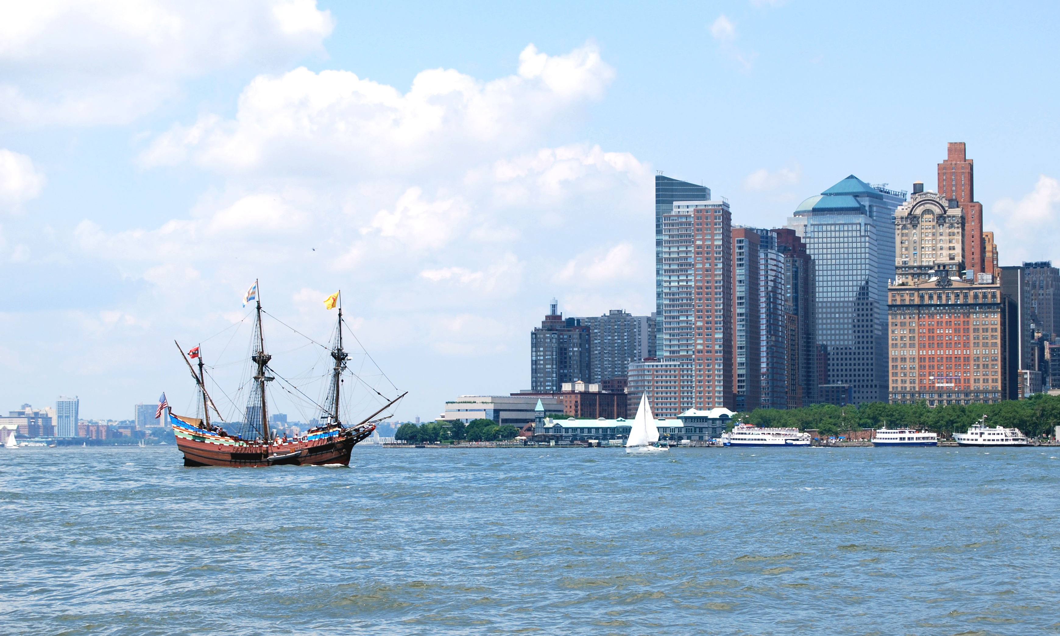
| | | | In this illustration of his ship, the Halve Maen, or Half Moon, (modern spelling: Maan), the cliffs known as the Palisades, the most dramatic geologic feature of the river, running 32 km (20 mi) on the west side of the lower Hudson, are visible. A Replica of the Halve Maen sails periodically on the river, especially now since New York this year is celebrating the Quadricentennial of Hudson’s voyage, 1609-2009. Here’s a view of it this summer in Upper New York Bay just off the southern tip of Manhattan, with New Jersey in the background, and the lower end of the Hudson River between them. I live in a low-lying building on the river just beyond those trees in Battery Park, and I’ve had the replica sail right below my windows.
| | | | To be fully accurate, it’s being called the Hudson-Fulton-Champlain Quadricentennial. We are simultaneously celebrating Robert Fulton’s development two centuries after Hudson of the first commercially viable steamboat, the Clermont, in 1807. It demonstrated that steam power could take a ship from New York to Albany and back in 62 hours (60h is 2.5 days). By the 1850’s some 150 steamboats were going up and down the “Rhine of America” connecting not only New York and Albany locally, but the entire east coast and Europe via the Erie Canal (1825, 584 km [363 mi]) to the Midwest and beyond.
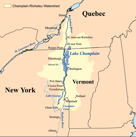
| | | | Getting back into our time period, we are also celebrating Samuel de Champlain, who founded Quebec City in 1608 and encountered what is today Lake Champlain in 1609. This lake is today partially in Quebec, but primarily it separates New York and Vermont. The lake drains via the Richelieu River into the Saint Lawrence, and when in 1823, two years before the Erie Canal opened, the lake was connected to the Hudson via the Champlain Canal (97 km [60 mi]), New York City was connected not only to the west, but to the north as well by water, water, water.
| | | | Champlain was a contemporary of Hudson and the two were exploring roughly the same area at about the same time in 1609, one from the south, one from the north. They never met, or even knew they may have been as close as 240 km (150 mi) to each other in the New World.
| | | | Before we get back to the settlement period, note that the Province of New York, successor to New Netherland in 1664, both already discussed in regard to the Delaware Bay area, had as its backbone not only both sides of the Hudson River but also both sides of Lake Champlain (more on NJ and VT later). In the southern portion of New York, Long Island was included to the east, and in its north, it grew to the west to Buffalo and Niagara Falls where it could, having to wrap around Pennsylvania (up to the Erie Triangle). It has therefore something of a Z-shape. Also, although New Jersey is no longer part of New York, New York still runs along the (upper) Delaware River, so that this river’s watershed supplies much of New York City’s water.
| | | | Furthermore, we’ve discussed earlier to a considerable extent the cultural context of the Hudson River, especially in the 19C, to which I’ll only refer here: in literature James Fenimore Cooper (Last of the Mohicans), William Cullen Bryant (Thanatopsis), Washington Irving (Legend of Sleepy Hollow; Rip Van Winkle) and in art, the entire Hudson River School of Cole, Durand, Church, Kensett, Bierstadt, and others. Also of note are the many great estates along the Hudson, including those of Morgan, Vanderbilt, Franklin Delano Roosevelt. And in 1802 there was founded the US Military Academy at West Point, actually on a point of land on the west side of the Hudson.
| | | | So now let’s go back to Upper New York Bay several years after Hudson’s visit in 1609. It was in May 1624 that a ship appropriately named the Nieuw Nederland brought settlers to the area to found Nieuw Nederland (which, again, lasted just forty years, to become New York in 1664). Their landing place was Noten Eylant (modern spelling: Eiland) or Nut Island, which was renamed Governor’s Island in 1784. This island hugs the coast of Brooklyn, where today the Brooklyn Passenger Ship Terminal is located and Cunard ships sail from. But the settlers decided to instead move a stone’s throw north over to the much larger island of Manhattan to found their capital of Nieuw Amsterdam, and the rest is history. | | | | It is a history I have no wish to repeat, except that we should take a look at the most remarkable map of the settlement, the Castello Plan. Unlike elsewhere in the New World, New Amsterdam’s beginnings were thoroughly documented. There was a census in 1660, and there remains a list of all citizens with their addresses. A map was drawn up by a cartographer as well, on which virtually every structure in town in existence that year is represented, and names and addresses can still be cross-referenced to the map. But what happened to the map is one of the most interesting parts of the story. In 1667, the cartographer bound the map into an atlas with other drawings, which he sold to Cosimo III de’ Medici, and off it went to Italy for two-and-a-quarter centuries.
| | | | It was then rediscovered in 1900 in the Villa di Castello near Florence. It was redrawn for further clarity, and republished in 1916 as the remarkable and appropriately named Castello Plan. Do not become disoriented by the fact that the map was drawn with North on the right. This is the southern tip of Manhattan (in the slender form it had in 1660), and that’s the East River at the bottom and the Hudson (Noort Revier) at the top. There is nothing left of the buildings you see, which all succumbed, not only to change, but to the several fires where large parts of the city burned. The entire visible heritage from the time of New Amsterdam remains in the street grid. Virtually all of the streets you see remain to this very day, some few even retaining their original names in translated form. However, the edges of Lower Manhattan have been expanded by landfill, so there are three to four additional streets that were added years later on each side between this street grid and each of the rivers.
| | | | There are only three main streets, all bending toward the East River, and connected by a number of small side streets. They bend because the whole town was oriented toward the more protected East River, where the ships docked. Note that the Hudson frontage, which was on a bluff (still visible behind Trinity Church), didn’t even have a street along it. The first major street (I’ll leave most names in the old spelling, and untranslated) is De Heere Straet, today’s Broadway, leading north beyond the wall into the countryside. At Broadway’s foot, even today, is Bowling Green (used at the time for playing ninepins), which at the time had Fort Amsterdam below it and, to the fort’s side, Het Marckt Velt (The Market Field, today’s very British-sounding Whitehall Street).
| | | | While the third major street on the right is Smee Straet, today’s William Street, it’s the major street in the middle that’s particularly interesting because of the long-gone canal (gracht) up its middle. It’s today’s Broad Street (the existence of the canal explains why it’s broad), which has the New York Stock Exchange on its upper west side adjacent to the misnamed Wall Street (name explained in 2007/17), although here you do see the wall.
| | | | What is today Broad Street was Heere Gracht up to the canal intersection, then Prince Gracht. The third arm of the canal was Bevers Gracht, and remains today Beaver Street. The lane below that was Het Marckt Velts Steegje and to this day is Marketfield Street, although its western end no longer exists, nor, for that matter, does any Market Field. Finally, notice the southernmost of the canal bridges. To its left was Brugh Straet, and is today still Bridge Street—but with no bridge in sight.
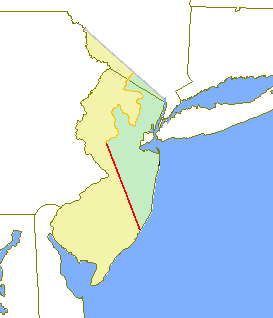
| | | | Province of New Jersey The spinoff winners among the colonies are Carolina and Virginia, each of which ended up being considerably smaller as states. The Province of New York, on the other hand, kept most of its original size after its own spinoffs. You can stretch matters by saying that, since all of New Netherland became New York, including everything along the Delaware, Pennsylvania had been part of New York, but since a new charter was issued for Pennsylvania, that’s really not the case. And even though Penn asked the Duke of York for Delaware as well, and got it, it’s a stretch to say that there was anything close between Delaware and New York before the giveaway. Yet New York did have two spinoffs, New Jersey and Vermont. New Jersey went early on, and became its own province before the revolution. Vermont separated only at the time of independence, so it never became a province. | | | | After the formation of the Province of New York from New Netherland in 1664, the area between the Delaware and Hudson Rivers remained part of it for ten years. Then, in 1674, the Duke of York parceled it away to two “Proprietors” who were loyal friends. The part along the Hudson was given to George Cartaret, who named the entire area after his ancestral home, the island of Jersey in the English Channel, and the part along the Delaware went to John, Lord Berkeley. However, these two areas were not united, and at this stage there were two Jerseys back-to-back, a West Jersey on the Delaware and an East Jersey on the Hudson. The border between the two was often disputed, but the most generally accepted line was the Keith Line of 1686, which went diagonally from northwest to southeast. This means that part of the Jersey Shore, including the present Atlantic City, although in the east, were part of West Jersey. Actually, this makes sense, since to this day this lower part of the Jersey Shore remains the de facto ocean shoreline for Philadelphia and its area. This two-way separation based on river orientation is also a parallel to the separation of the upper Delmarva Peninsula between Maryland and Delaware for the same reason. [Also note on this map that the northern border with New York was eventually moved further south.]
| | | | But unlike the separation of Maryland and Delaware, the division of Jersey lasted only 28 years, from 1674 to 1702, at which point, because of numerous conflicts between the Proprietors, they were united into a single royal colony. No one thinks about two Jerseys today, but the past always remains with us, and the 1686 Keith Line has left its trace. Note how, on this map of New Jersey Counties, you see remnants of the diagonal line on the east side of Burlington County aligning with, further north, the west side of Somerset County.
| | | | Now, given some 20C New Jersey history, the following statement might sound like a joke, but this really was the case: it seems that the first royal governor that was appointed was found to be corrupt and ineffective and was sent back to England. Thereupon, in 1708 the New York governor was appointed the governor of New Jersey as well, and NJ went back to its symbiotic relationship with NY. This lasted for three decades, until a separate NJ governor was again appointed in 1738. | | | | Wondering about which of the two river orientations of NJ is primary, it is significant to understand that, not only was there the relationship with NY, but also in the first ten years, it was into the Hudson region that significant settlement came; curiously, it was primarily from New England.
| | | | Finally, there is the quirk about the name. Aside from New Jersey, there is New York, New Hampshire, New Mexico, and even New England, yet it is only with New Jersey that the word “New” has become only an optional formality. You cannot drop that word from any of the others, but it is extremely normal to say “I live in Jersey”, or “That’s Jersey across the river”. It would appear that the full name is used only on more formal occasions, and the short form informally. For instance, although the signs all read “New Jersey Turnpike”, everyone says they’re taking the Jersey Turnpike. People also say they’re going to the Jersey Shore, and I’ve never heard the word “New” used in that phrase. My personal view is that it’s all a result of history. The word “New” was never a part of the names West Jersey and East Jersey, and the ease of omitting it now has come down to us from its omission at that time.
| | | | Vermont While New Jersey separated early enough to become its own colony, Vermont was a different situation. New York had always maintained large land areas on both sides of its Hudson River-Lake Champlain backbone. Although New Jersey was an early loss, neither Connecticut or Massachusetts ever successfully extended itself down into the Hudson Valley. The east side of Lake Champlain, which today is Vermont (see map above), had been problematic, though, since New Hampshire also claimed the area. However, in 1764, George III confirmed New York’s claim and established the boundary between NY and NH at the Connecticut River north of Massachusetts.
| | | | But that decision dissatisfied some colonists that had moved in from NH, and in 1777, during the Revolutionary War, Vermont broke away from New York and became a republic. For the first six months it called itself New Connecticut, then named itself after the Green Mountains (ver+mont) that run its length. Vermont minted its own coinage and had its own postal system, and exchanged ambassadors with France, the Netherlands, and the American government then based in Philadelphia. But the Vermont Republic existed only during the Revolutionary War and lasted only fourteen years, 1777-1791, at which time it joined the US as the 14th state, in other words, the first state after the thirteen colonies.
| | | | There are four states that have been independent republics: Vermont, Texas, Hawaii, and the short-lived California Republic, which existed for one month in 1846 during the Mexican-American War. Its only legacy was its Bear Flag, which also included a single star and the words “California Republic”. All three of these items are retained, in redesigned form, in the current state flag of California. | | | |
| |
|
|
|

