|
Reflections 2009
Series 25
September 27
The Thirteen Colonies, 1600-1800: V
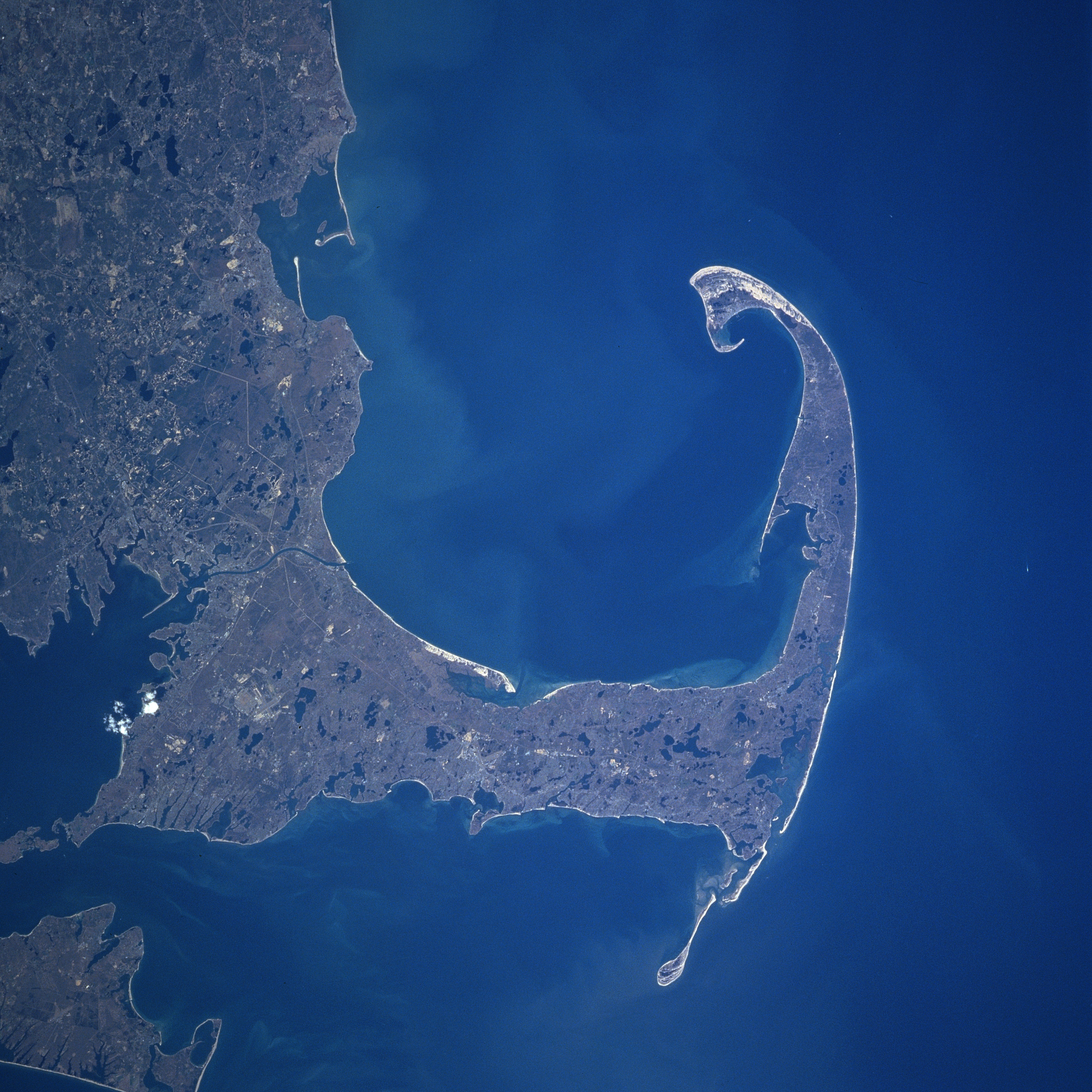
| | Cape Cod & Massachusetts Bays: A Settlement Area At some distance from the three settlement bays discussed so far is the pair of twin bays further northeast, Massachusetts Bay and Cape Cod Bay, demarcated by Cape Ann to the north, and by one of the most distinctive land features in eastern North America, Cape Cod, to the south. Let’s look first at a satellite image of Cape Cod & Cape Cod Bay. Even though this shows contemporary features, it will still give a feeling of the geography the settlers found at the beginning of the 17C.
| | | | Unfortunately, the image is slightly rotated clockwise to the right (north would be at about the one o’clock position), so it detracts slightly from the powerful counterclockwise nature of this land feature, which will be more apparent in later maps. But start by noting Plymouth on the left (described by locals as being “off-cape”--as is the rest of the world). Proceeding counterclockwise around the bay, you first enter Barnstable County, within which the Cape proper is located, then cross the Cape Cod Canal, built in 1914 to ease shipping, and you find you’re on what is referred to as the Upper Cape. If you liken the Cape to the arm of a strongman, the Upper Cape includes his “shoulder” (Martha’s Vineyard is visible to the south); as you continue further to the bend of his “elbow” you’re in the Mid-Cape; as you go northwest to the end along the part of the Cape most exposed to the open sea, his “forearm”, you’re in the Lower Cape, a term many avoid as sounding negative, so they replace it with Outer Cape. The Outer Cape is arguably the only place on the US east coast where you can see a sunset over water. Near the end, his “hand”, the sand dunes are visible, ending in the “knuckles” of Race Point, which faces due west. But the swirling, spiraling nature of the local geography doesn’t end there, since the spiral continues further to the “fingers” at Long Point, a spit of land that actually points northeast! Long Point then protects the harbor of Provincetown, which perhaps somewhat surprisingly faces southeast as the lay of the land turns and turns. Given the clear orientation of Provincetown toward the Bay, it’s understandable that the dune area is called The Backside. | | | | Given the simple nature of a cape as an outer point around which currents and ships revolve, it becomes understandable that in the early 1600’s, only the Provincetown area was considered to be Cape Cod, which then just happened to be at the end of an oddly-shaped, rather long and slender peninsula. In time, though, the name spread along the length of the peninsula. Today, even some people generously include Plymouth within the sphere of Cape Cod, given its position on Cape Cod Bay.
| | | | Cape Cod, as well as the islands of Martha’s Vineyard and Nantucket directly south of it, were formed as a terminal moraine of the glacier that reached this point, leaving a strip of debris. Cape Cod is in reality one of the biggest barrier islands in the world, protecting Massachusetts from storms, one that just happened to get attached to the mainland.
| | | | We should now look at this map of Two Bays & Two Capes, which will help to clarify the area. Note here the correct orientation of Cape Cod, how its tip is well north of Plymouth, and how it encircles Cape Cod Bay. Then note directly adjacent another bay, Massachusetts Bay, which is more open to the sea, and deep in its west end, Boston. North along the shoreline at the indentation would be Salem, famous for its witch trials, and at the end is Cape Ann, the compliment to Cape Cod. Cape Ann is famous for picturesque Rockport, and Gloucester, the oldest seaport in the nation. This two-bay region with its two capes is the settlement area that sparked most of New England.
| | | | The peninsula known as Cape Cod juts out so prominently on the east coast of North America that it kept attracting early visitors. It could have been the “Promontory of Vinland” mentioned by Norse explorers. Verrazano approached it in 1524. Then the area really became busy in the first two decades of the 1600’s. In 1602 an explorer named Bartholomew Gosnold stopped there, was impressed by its cod-filled waters, and gave it its name. Cape Cod is the ninth-oldest surviving English place name in the US. Then Champlain charted it in 1606. Hudson landed there in 1609 (it’s his Quadricentennial, remember, and he didn’t bump into Champlain here, either). Captain John Smith, having left Jamestown for England in 1609 never to return to Virginia, in 1614 went to Massachusetts and Cape Cod Bays, charted them as well, and was the one who named the region New England. Finally, Cape Cod Bay became the area accidentally stumbled upon, and then finally chosen, by English settlers in 1620, the ones commonly referred to in US mythology as “Pilgrims”. | | | | [So the travel cynic speaketh again. While the history of all four settlement areas is of seminal importance to the start of US history, for some reason this second location of successful English settlement (Jamestown was first) has grown beyond decent historical bounds into a mythology, or perhaps a “traditional” history not subject to facts, such as Washington’s cherry tree. The nonsense of Plymouth Rock (to follow) is one key part of this, as is the exaltation of the Mayflower as being the first vehicle of arrival, and not the Susan Constant to Jamestown fully thirteen years earlier. The arrival of the “Pilgrims” was of major importance, and it was different from the other settlement areas in that the others were settled by entrepreneurs, while the “Pilgrims” were escaping religious persecution. Still, that doesn’t make them pilgrims, such as ones to Santiago or Lourdes, even though “Pilgrims” is the term commonly applied in the US to early European settlers of Plymouth Colony. I will report all, but with due cynicism where justified.]
| | | | Plymouth Colony The so-called “Pilgrims” were members of a separatist group of English Puritans from the English Midlands who tried to reform the Church of England, and were then persecuted. They fled to the Netherlands for over a decade in Amsterdam and Leiden before deciding to come to the New World in 1620. The Dutch tried to get them to try to settle on the Hudson River, which they considered, but they preferred to maintain an English identity. (The Dutch got their New Amsterdam settlement going four years later, in 1624). These English settlers instead decided to go to Virginia, since Jamestown was already established there, but considered setting up their own colony so as not to duplicate the political environment they had left in England. In any case, Jamestown could help them with security and trade. However, since they never got to either the Hudson or Virginia, their final choice between the two remains moot. Upon leaving the Netherlands, they had difficulties with ships, and, as they sailed westward, put in to Southampton, and then finally Plymouth, where they found that only the Mayflower was seaworthy enough to make the voyage. Actually, then, it was by chance that their last stop in Europe was Plymouth. | | | | On the way to Virginia, they were diverted north by a storm, and arrived instead in Cape Cod Bay. Given the spiral shape of the peninsula and the fact that they were fleeing a storm, it should be no surprise that they curled around Long Point in the very center of the spiral and anchored at what only a century later would become Provincetown. Still, this natural “Provincetown” harbor is where they would make landfall on 11 November 1620. Furthermore, they were not entirely unfamiliar with the bay, since it had been charted six years earlier by Captain John Smith, late of Virginia, where they were headed.
| | | | But while at anchor in the harbor, realizing that there was no government in the area, many of the men on the ship composed and signed a document that has come to be known as the Mayflower Compact, in which they agreed to abide by laws made by leaders of their own choosing when they went ashore. This document, the original of which went lost but that survives in copies, would become the first governing document in Plymouth Colony and was the first democratic constitution in what would become the United States.
| | | | They spent five weeks exploring. Further south on the Bay side, in what is today the town of Eastham on the inner elbow of the Cape, they had their first encounter with Native Americans, each side sizing the other up. This is commemorated today at First Encounter Beach. | | | | Still, Virginia had been their goal, and they made a second attempt to reach it, but were detoured once again by strong winds, and decided to stay. Given their experience with the winter weather, it should not be surprising that they did not settle on the Outer Cape, but instead crossed over to the mainland side of the Bay where they landed on the beach at what they at first named New Plymouth, but which eventually became simply Plymouth in Plymouth Colony. There was no report whatsoever in any of the journals of any sort of a memorable “Rock”. Thus Plymouth did become the first permanent settlement in New England, but only the second one, after Jamestown, in what would become the United States, all mythology notwithstanding.
| | | | But if everything started with Plymouth and Plymouth Colony, why is the state today called Massachusetts, and why is Boston and not Plymouth the capital of Massachusetts, the principal city of all of New England, and the northern end of the Northeast Corridor? It comes down to sibling rivalry between the two bays.
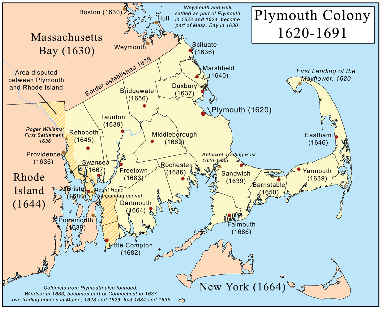
| | | | Massachusetts Bay Colony In the first decade of the existence of Plymouth Colony, there was settlement at the other end of the bays along the north shore leading to Cape Ann, including Gloucester (1623) Salem (1626) and Boston (1630). The Massachusetts Bay Colony was chartered in 1629, and the charter became effective in 1630. In time, the center of activity moved from Cape Cod Bay to Massachusetts Bay—in a sense, the tail was wagging the dog. In 1691 Plymouth Colony was actually annexed to Massachusetts Bay Colony, which in the long run, developed into the State of Massachusetts (and not anything like the “State of Plymouth”). This map of Plymouth Colony is illustrative. Notice the border with Massachusetts Bay, making just about all of the southeast corner of today’s Massachusetts the location of Plymouth Colony. The obvious exception to that are Martha’s Vineyard and Nantucket, plus a few other islands, which, do recall, were part of the New Netherlands claim almost reaching to Cape Cod, and then becoming New York. (!!!) For later reference, note the disputed border with Rhode Island (areas which all went to RI), note the depth inland of Narragansett Bay in RI, up to Providence, and note the island which has Portsmouth on it, and which now has the more famous Newport at its south end. | | | | Province of Massachusetts Bay But here’s a surprise. Massachusetts is the only colony that expanded considerably EASTWARD. The 1691 document that merged Massachusetts Bay Colony and Plymouth Colony also included Martha’s Vineyard and Nantucket, and, with one exception, all the land eastward, including Maine and all of Nova Scotia, which at the time, even included New Brunswick! It also changed the name of this new entity to the Province of Massachusetts Bay. However, Nova Scotia (with the later New Brunswick) was separated out again in 1696, but that still left Maine as part of Massachusetts. | | | | Province of New Hampshire That exception in the 1691 charter was New Hampshire, named after Hampshire in England. Note on this variation to the maps of the capes the location of the tiny seacoast of New Hampshire and its very close proximity to Massachusetts Bay. | | | | The Colony of New Hampshire had existed since 1623 but, like Pennsylvania-Delaware and New York-New Jersey, had always had a very close, symbiotic relationship with Massachusetts Bay, being joined to it off and on. The 1691 charter finally officially declared its separation as the Province of New Hampshire, yet the two continued to share a governor until 1741! | | | | The tiny coastline of New Hampshire is the shortest in the US. I’ve driven its length of 28 miles (45 km) and one zips from Massachusetts to Maine in no time. Significant, however, is Portsmouth, where Theodore Roosevelt arranged for the Treaty of Portsmouth to end the Russo-Japanese War. Yet it is a coastline as most New England states have, indicating settlement from the sea, whereas Vermont, thoroughly part of New England today, and to some extent settled overland from NH, has a history connecting it with NY and the Hudson River.
| | | | Maine Like Vermont, Maine was a child of the post-Revolutionary War period, and was never a colony. It remained a part of Massachusetts until it gained statehood in 1820. It illustrates my theory that Maine would never have existed except for New Hampshire being given its own existence, right up to the coast. There is a sometime tendency for physical separation to develop into separate governments, such as East and West Pakistan eventually becoming Bangla Desh and Pakistan.
| | | | Some ponder if the name Maine comes from the area of France called Maine (pronounced MEN), but I lean toward the alternate explanation, that locals living on the many offshore islands talked about going over to the main, meaning the mainland, and that developed into its name. It is the only one-syllable state name in the US.
| | | | Colony of Rhode Island and Providence Plantations The New England colonies to the south also had Massachusetts roots. This includes Rhode Island, about which everyone always asks: Where’s the island? | | | | This, the smallest state today, is defined by its location in and around Narragansett Bay (actually, so is Connecticut), and, small as it is, it is a combination of two separate colonies, just as Massachusetts is.
| | | | In 1636, Roger Williams, fleeing religious persecution in Massachusetts (ironic, given its history) established at what is today the capital of Providence, the colony he called Providence Plantations, to emphasize its dependence on agriculture (see map above). The next year, 1637, Anne Hutchinson, another religious leader (I lived near a Hutchinson River, with a HR Parkway, in Westchester County NY) founded a settlement on the largest island in Narragansett Bay, Aquidneck Island, in what became the town of Portsmouth, and which now includes the famous Newport at its southern end. The dirty little secret is that this large Aquidneck Island, then and today, goes under the alternate name of Rhode Island. Today, though, people avoid calling it that, since it confuses the island with the state. The two colonies, along with other settlements, sought protection with a charter, granted in 1644 to the Colony of Rhode Island and Providence Plantations. Thus the smallest state today, which has retained that name, has by FAR the longest official name, which is imprinted on all official seals. I read in the New York Times that this summer, the RI legislature has decided to put shortening the name of the state up for a referendum, based on negative Civil War connotations of the word “plantation”. (Consider this though on keeping a double name: what if Massachusetts today were known as Massachusetts and Plymouth?)
| | | | But how about the name Rhode Island? As in Maine, there are two possibilities, one more plausible than the other. The less plausible is that, when Verrazano sailed into Narragansett Bay and saw so many islands, it reminded him of the Greek islands and he named the largest one after Rhodes. I don’t buy it. Why Rhodes and not another island?
| | | | The much more plausible explanation is the one officially espoused by the state. And I love it, because it’s a language issue, dealing with Dutch. Remember, the Dutch considered this entire coastline up to Cape Cod theirs, and the Dutch explorer Adrian Block investigated the area, so that Block Island in the Atlantic, separated from the end of Long Island by Block Island Sound (I stopped on the island on a New England cruise), is named after him, one of the few Dutch names remaining in New England. Well, when Block was visiting Narragansett Bay, he noticed that its largest island had deposits of red clay, so he named that island Red Island. A lie—he actually named it, in the old Dutch spelling, Roodt Eylandt, pronounced just the way Rhode Island is today.
| | | | Colony of Connecticut The Colony of Connecticut was organized in 1636. It was originally called the River Colony, indicating the importance of the only major river in New England, the Connecticut River. It was another example of trying to counter Dutch influence, since Adrian Block had already sailed up the Connecticut River in 1614 and trading posts had already been established. King James I granted settlers the right to settle the area west of Narragansett Bay all the way to the Pacific Ocean. This involved an overlapping claim, since both sides of Narragansett Bay were, and still are, part of Rhode Island. It was resolved in RI’s favor, yet still the distance that Narragansett Bay reached inland still predicated the north-south height of Connecticut, just as it did Rhode Island. Settlers arrived in Boston, and rushed to Connecticut to counter the Dutch. English settlers then moved into the Connecticut Valley from other parts of New England. Actually, two additional colonies were merged into the Colony of Connecticut, Saybrook Colony in 1644 and New Haven Colony in 1662. | | | | Of all the sea-to-sea grants, the one to Connecticut had an existence that was more tenacious than usual. This map of the Connecticut Western Claims shows a number of things. Note how all of New England except Vermont clusters around eastern Massachusetts and was in a position to be influenced in one way or another by it. Note also the short coastline of New Hampshire in contrast with other coastlines. Some local Connecticut claims, including one to Long Island, were settled still in the late 1600’s, and the Hudson Valley remained untouched. But CT still claimed the entire northern strip of Pennsylvania and beyond west through what is now Chicago even through the Revolutionary War, ceding the eastern and western ends of this claim only in 1786. But like a bulldog it continued even after that to claim an area along Lake Erie west of Pennsylvania called the Connecticut Western Reserve for fourteen more years, finally giving up in 1800. This area eventually became a large part of northeastern Ohio. I had always heard of an Ohio school called Western Reserve University (1826), recently merged and now known as Case Western (Reserve University). I’d wondered what was reserved, and what it was west of, and now it becomes clear. The school is located in Cleveland, which would have been a Connecticut city if the claim had held. | | | |
| |
|
|
|

