|
Reflections 2016
Series 17
October 25
East Coast VIII: Gullah - Charleston 2
| | The Gullah The Gullah, also known as the Geechee, are the descendants of enslaved Africans who live in the Lowcountry of the Southeast. Because of their relative isolation in rural areas, the Gullah developed a culture that has preserved much of the African linguistic and cultural heritage from various peoples.
https://nwsisdmrc.files.wordpress.com/2013/11/gullah-geechee.jpg
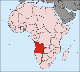
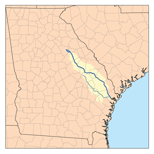
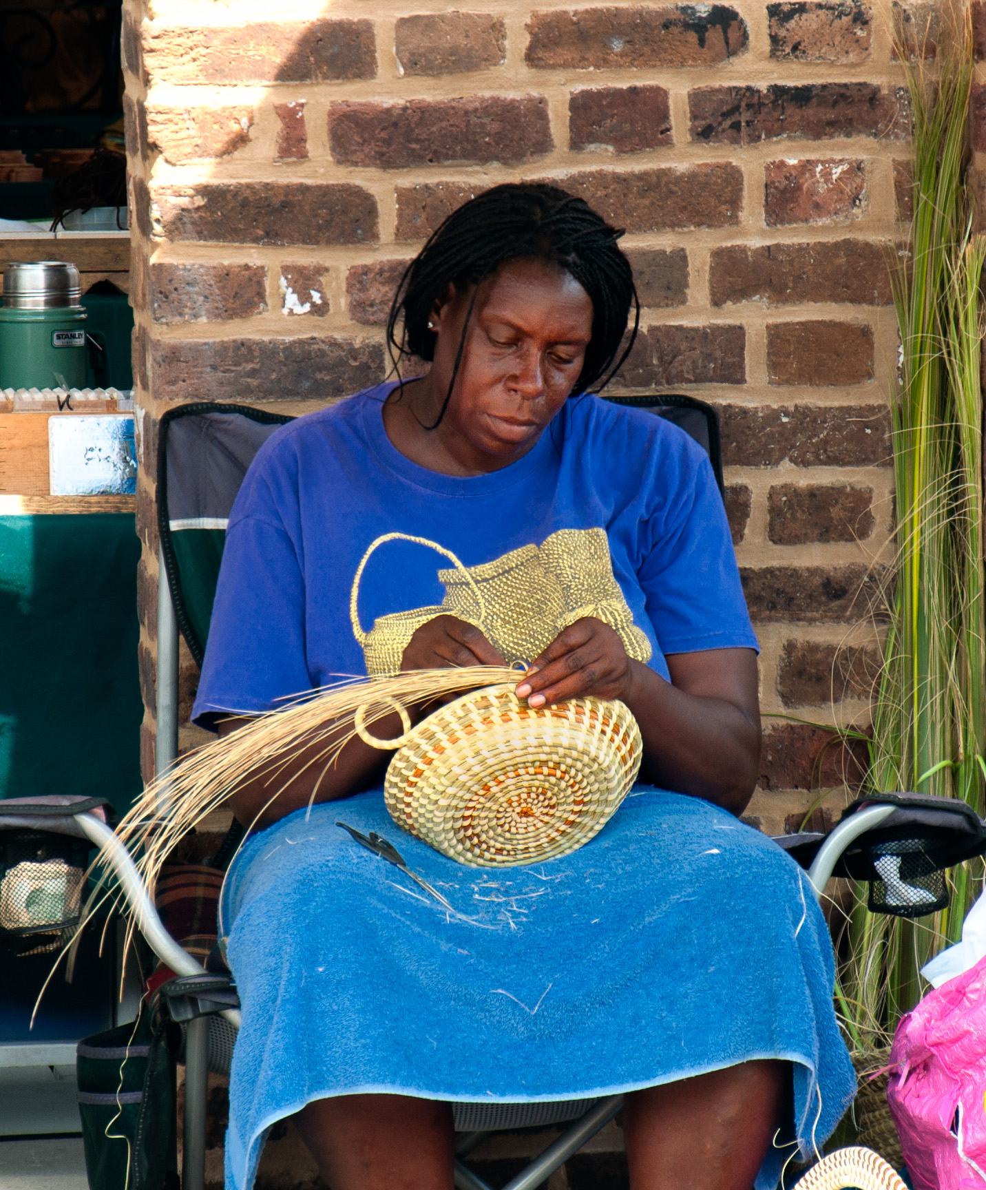
| | | | This is the Heritage Corridor of this cultural and language area. It principally covers the Lowcountry of South Carolina and Georgia, although historically, the area extended somewhat beyond, in the south to the Jacksonville area of Florida, and north to the Cape Fear and Wilmington area of North Carolina, which we'll be visiting later. (Note on the map Jasper County SC, the name connected with Fort Moultrie in the last posting.) Whatever the extent of the area, Charleston is in the center of it. | | | | The origin of the name "Gullah" is not known, but it could come from "Angola" (Map by User SonicR), which is where some Gullah ancestors originated, although far more came from further north, in West Arica, and from East Africa. The alternate name "Geechee" is derived from the Ogeechee River (Map by Kmusser) near Savannah. | | | | In the times of slavery, the culture and language developed internally, not meant for outsiders, who most likely weren't interested, anyway. This has continued into modern times, when speaking in Gullah is reserved for insiders—again, outsiders wouldn't understand much of it, anyway. Anyone may sense just a bit of the Gullah situation who feels they speak with more regionalisms with family and friends as opposed to more standardly with outsiders. There are also local Gullah festivals and Lowcountry food fairs, where the culture and language express themselves. | | | | First Lady of the United States Michelle Obama has Gullah ancestors on her father's side in the SC Lowcountry. Her paternal great-great grandfather, Jim Robinson, was enslaved on a SC plantation, and some of her father's family still reside in SC. | | | | Associate Justice of the United States Supreme Court Clarence Thomas is himself Gullah. He was born in Pin Point GA near Savannah, a small predominantly black community founded by freedmen after the Civil War. His parents were descendants of enslaved ancestors, and the family spoke Gullah as a first language. Thomas was raised after the age of six by his English-speaking grandfather in Savannah, where he learned standard English. But fearing he still sounded unpolished, in college he decided to major in English literature to learn even more. | | | | Gullah Culture We've already seen one manifestation of the culture, sweetgrass baskets, which are defined as coil straw baskets (Photo by Bubba73) made by the Gullah of the SC Lowcountry. This is a Gullah woman (Photo by Mattstone911) making a sweetgrass basket in the Charleston City Market, and these baskets are almost identical to coil straw baskets made by the Wolof people in Senegal, as seen below.
https://cdn.shopify.com/s/files/1/0923/3400/files/Senegal_Basketweaving.jpg?6149106968601954606
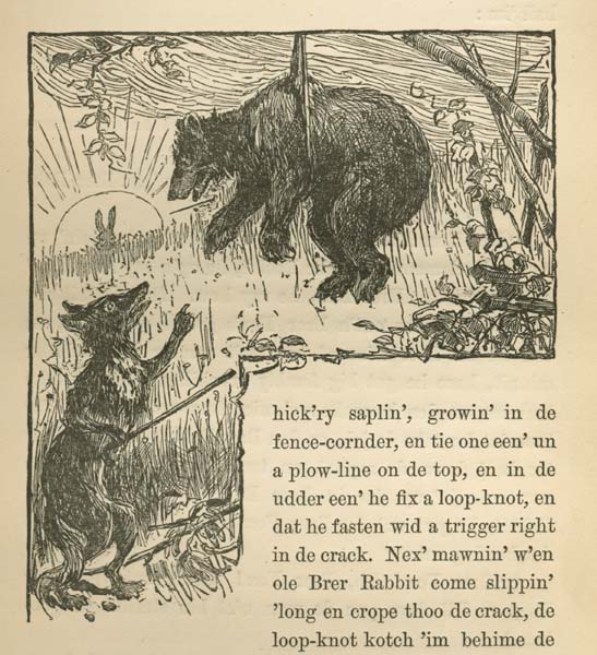
| | | | What's surprising here is that this should be surprising. If many Scandinavians are good woodworkers, we wouldn't be surprised to see Scandinavian-Americans who are the same. But that's a connection with Europe. Yet a connection between Africans and African-Americans is something we apparently don't expect to discover. | | | | Folk tales told in West and Central Africa even today are often trickster tales that involve a clever and conniving rabbit, spider, or tortoise who tricks its adversaries and usually comes out ahead. In Gullah culture, this appears in stories about Br'er Rabbit (Br'er = Brother, rhymes with "there"). Br'er Rabbit, similar to the hare in African tales, is a folk-hero trickster who succeeds against larger adversaries like Br'er Fox, Br'er Wolf, and Br'er Bear by wits rather than brawn. This is Br'er Rabbit dealing with much larger Br'er Fox:
https://octoroonc1.files.wordpress.com/2015/11/brer-rabbit-and-brer-fox-4-1.gif
| | | | Some scholars believe that Br'er Rabbit, as he provoked authority figures, represented the enslaved Africans in the Lowcountry who had to use their wits to overcome adversity and exact revenge on their adversaries, the slave-owners. These tales were popularized in mainstream culture by Georgian author Joel Chandler Harris, who adapted and compiled African-American folktales in which he had a fictional, elderly black man named Uncle Remus narrate the stories. Harris was a journalist in Atlanta, and the stories first appeared individually in newspapers, and were syndicated nationally. They were first compiled in book form in 1881 as "Uncle Remus: His Songs and His Sayings", the first of seven books. This is Uncle Remus as illustrated in the book. Mark Twain and Rudyard Kipling commented positively on Harris's work. | | | | Chandler did not write in Gullah, but devised what's called an eye dialect, using words and odd spellings visually representing non-standard speech to represent what would otherwise have been Gullah. This is another illustration from the 1881 book showing Br'er Rabbit winning out over Br'er Bear. Note the eye dialect in the text. I particularly like "crope" for "crept" and "kotch" for "caught". | | | | It would seem that the whole genre called Negro Spirituals might fit in here, but I'd rather talk about two folk songs of note. Anyone who knows the name of the first one, Kumbaya, already knows a Gullah word, actually three, since what you're saying is actually Gullah "kum ba yah" or "come by here". It was first recorded in the 1920s and spread in popularity during the folk music revival of the 1950s and 1960s, and has now spread internationally, though many who sing it are unaware of its background. This on YouTube is Kumbaya (3:29), sung in Australia by Judith Durham and the Seekers. Think of the meaning of the word as you understand it in context. | | | | The other one we're citing, Michael, Row the Boat Ashore, is even older, and probably most accurately does fit into the genre of Negro spiritual, although it's widely considered a folk song. It was first noted down during the Civil War at St Helena Island, one of SC's Sea Islands. It was sung by former slaves whose owners had abandoned the island before the Union navy arrived to enforce a blockade. A Harvard scholar and abolitionist who had come to supervise the plantations on St Helena during the war from 1862 to 1865, wrote the song down as he heard the freedmen singing it. It was first published in "Slave Songs of the United States" in 1867. | | | | As this song originated in oral tradition, there are many versions of the lyrics, and most of them today have been changed into standard English. But the oldest published version above runs in a series of unrhymed couplets. These might be full-blown Gullah, or might just show a flavoring of Gullah. The song is addressed to the Archangel Michael, the Angel of Death, and talks about crossing the River Jordan to the promised land. This is just a selection of four of the couplets. | | | | | | I wonder where my mudder deh [there].
See my mudder on de rock gwine home.
. . .
Brudder, lend a helpin' hand.
Sister, help for trim dat boat.
Jordan stream is wide and deep.
Jesus stand on t' oder side.
I wonder if my maussa deh.
My fader gone to unknown land.
|
| | | | This is a YouTube recording of Michael, Row the Boat Ashore (2:44), sung in a version in standard English by the Highwaymen. Much is different, but you'll hear Gullah parallels. | | | | Pidgin and Creole Languages A pidgin language is a simplified means of communication that develops ad hoc between speakers of two (or more) languages, using elements of both, such as between bosses and workers of two different cultures, in order to get work done. While the origin of the word is uncertain, the most widely accepted etymology is that "pidgin" developed from a Chinese pronunciation of English "business". If that really is the case, the word itself demonstrates the type of blend we're talking about. There are numerous pidgins around the world; just picture how many language borders there are where different languages and cultures come together, and neighbors have to communicate.
| | | | A creole language is a complete, natural language developed from a mixture of other languages. It's acquired in childhood as a native language and is used within a community. However, it takes no great leap of imagination to see how perhaps a well-established pidgin passed down to another generation can develop into a creole. The process where an alternate language of adults becomes the native language of children is called nativization, and can change a pidgin into a creole. | | | | There are also numerous creole languages, and often the nucleus is a major language. We'll mention a couple of well-known ones. Possibly the best known is Afrikaans in South Africa, centered on Dutch. It's one of 11 official languages there. Although Afrikaans has adopted elements from native African languages and others, it's largely Dutch based, and there's a high degree of mutual intelligibility between them. | | | | Based on French is Haitian Creole, which, with French, is an official language of Haiti, although most Haitians speak only Creole, which is not mutually intelligible with French. In the past I've talked about Papiamento, which is centered on Portuguese (although I've thought, and said, it was centered on Spanish). Papiamento is official in Aruba and Curaçao, and recognized by the Bonaire government. Dutch is also official in all three (plus English in Curaçao). Both Haitian Creole and Papiamento have a large blend of African languages within them. | | | | English seems to have the most creoles, and many of them are in the Caribbean, and, too, have a large African blend. Among many others in the region are Trinidadian Creole, Bahamian Creole, and Bajan Creole in Barbados. English is official in all three, though Bajan is recognized in Barbados. But the creole language centering on English that we are interested in here is Gullah. | | | | | | The origins of the word "creole" imply servitude. Portuguese criar is "raise, bring up"—note that a criança is a child--which developed into cria referring to a person raised in one's house, but especially a servant. The diminutive is crioulo, which moved to Spanish as criollo to refer to a person native to a locality, then to French as créole, and to English as "creole". But the original "servant" reference often remains as an undertone so that these locals in question tend to be simpler folk, though not always. |
| | | | The Gullah Language Gullah, also called Geechee, is an English-based creole that contains many African loanwords and that is influenced in grammar and sentence structure by African languages. It did begin to develop from a pidgin used between the tribesmen brought from Africa by the slave traders. It was used with them, and later with overseers on the plantations, at which it was further influenced by the English dialects the overseers used. Speaking their native African languages on the plantation was typically forbidden, presumably in an attempt to break the workers from their past. Thus Gullah/Geechee allowed them the freedom of communicating with each other, both in speaking and singing, in a way accepted by the whites, but not understood by them. By the mid-18C Gullah moved from pidgin to creole status as a new generation grew up speaking it natively. Today, about 250,000 people speak Gullah in the Lowcountry of SC and GA. | | | | Some scholars believe that Gullah has changed little since the 19C, but change is inevitable. It is most likely that some African-influenced vocabulary or grammatical structures that were prevalent then might have diminished now, a process called decreolization. As a matter of fact, pure Gullah is seldom heard anymore as older speakers die off and as English influence becomes stronger. | | | | Gullah was stigmatized for generations by outsiders, regarding the language as broken English and a mark of ignorance and low social status. This sort of development will always force speakers of a language to limit its us to the safety of their own homes and local communities. On the other hand, some speculate that that helps preserve the language as a sign of belonging to a group. Justice Thomas, when asked why he has little to say on the Supreme Court attributed that fact to the ridicule he had received for speaking Gullah as a young man, and so, he says, he developed the habit of listening rather than speaking in public. In recent years, educated Gullah people have begun promoting Gullah openly as a symbol of cultural pride. | | | | Grammatical Structure Gullah has everything necessary to qualify as a language, grammar, phonology, an extensive vocabulary, and idioms. Except for phonology, which can get very technical, we can give examples of the other three, starting with grammatical structure. | | | | The following, taken directly from the Wikipedia article on Gullah, shows how shades of meaning can be expressed in Gullah just as they can in English or any other language, in this case, using verb tenses. Note how English words are used to form tenses in a way different from how standard English does. The sequence below is (1) Gullah, (2) what it actually corresponds to in English, (3) tense identification, (4) the literal translation (not the meaning): | | | | | | Uh he'p dem ----- I help them/I helped them - (Present/Past Tense) – [I help them]
Uh bin he'p dem ----- I helped them -------- (past tense) ------------ [I been helping them]
Uh gwine he'p dem -- I will help them ------ (future tense) -----------[I'm going to help them]
Uh done he'p dem --- I have helped them -- (present perfect tense) -- [I done helped them]
Uh duh he'p dem ------ I am helping them --- (present continuous) -- [I do help them]
Uh binnuh he'p dem --- I was helping them --- (past continuous) --- [I been helping them]
|
| | | | Do not be put off by the first entry corresponding to both present and past, as that's done all the time in English narratives. You can use present for past in English--all you need is some other expression indicating past time: "Last week he comes home and says to her . . . " | | | | Words From Africa Our language family, the Indo-European, is largest as to number of native speakers, and second is the Sino-Tibetan language family. But third largest worldwide is Africa's Niger-Congo language family. It's also Africa's largest in terms of geographical area, number of speakers, and number of distinct languages. The most widely spoken by number of speakers is Swahili. This map shows the distribution of the Niger-Congo languages (click) (Map by Ulamm). Brown is the Bantu subfamily.
| | | | Gullah has taken a lot of vocabulary from these languages, but there's no need to even look at that. Instead, we're going to try to show words that have entered English--sometimes just American English, sometimes English internationally. There are far more than you may think, but they may have arrived into English in many ways, some perhaps directly, such as "safari" and "bwana" from Swahili or "impala" from Zulu, or through Europe, such as "banana" from Wolof via Spanish or Portuguese. I've attempted to limit the below selection to some common ones that definitely—or probably--arrived via Gullah. | | | | Many Africans were taken from what is now the Democratic Republic of the Congo and the Republic of the Congo where the Kikongo language is spoken (see language map). Kikongo tota "to pick up"; Gullah "tot"; English tote. We usually prefer to use "carry", but everyone knows what a tote bag is. | | | | We come to a series of foods. Senegal, in West Africa, is home to the Wolof people (see baskets above). Wolof nyam "taste"; similar in other languages, such as Bantu nyambi "eat"; English yam. | | | | Igbo is a language of Nigeria. Igbo ókùrù "okra"; also in Ghana, Akan nkruma means the same thing; English okra. It was a food plant indigenous to Central Africa and brought over by enslaved Africans. Mbundu is the most widely spoken language of Angola; Mbundu ngombo "okra"; in Gullah, "gambo" means "okra"; English gumbo "gumbo (okra stew)". It's unusual that two words came into English from different African languages, one referring to the vegetable and the other to the stew thickened with that vegetable. | | | | Mbundu nguba "peanut"; Gullah "guba"; English goober. Though the usual word is "peanut" in English, dialectically and otherwise, it can be a goober or goober pea. | | | | | | Later in the current year, on a trip on the Erie Canal, I was talking with the ship's lecturer, Will Van Dorp. He had been in the Peace Corps, teaching high school in Équateur (Equator) Province in the NE part of the Democratic Republic of the Congo, where the local language is Lingala, a Bantu lingua franca. Will pointed out to me the word nguba that Lingala had absorbed from other local languages and how it had reached English, and I pointed out that I was aware of that word through Gullah. Beyond the fact that this was an unusual topic of conversation, Will was a witness to the exportation of the word from Africa across the Atlantic, and I was a witness to its importation via Gullah into American English. |
| | | | Wolof and Yoruba (in Nigeria) jiga "insect"; Gullah "jiga" is "insect"; English chigger. A chigger is a microscopic mite, like a tick but much smaller, that burrows under the skin. | | | | There are many more, but let's end with something called a loan translation. Mandingo in Senegal has an expression da-jugu and Hausa in Nigeria uses mugum-baki. Both mean "to slander, abuse verbally". Gullah did not use those words per se, but translated them instead, and from that translation, in English we have the phrase to bad-mouth someone. | | | | Idioms One of the most interesting features of Gullah is the frequent use of idiomatic expressions. While these expressions are both meaningful and colorful, and while they contribute to the charm of the language, they also make it difficult to understand. I've chosen some favorites that were distributed on a flyer during the Gullah tour. | | | | | | 'E sweet mout' me
Tie yuh mout'
'E turn 'e head
Steady [study] yuh head
Mah head leeb [leave] me
Don' git los' now!
| He flattered me
Stop talking
He changed his mind
Think hard
I forgot
Come back soon!
|
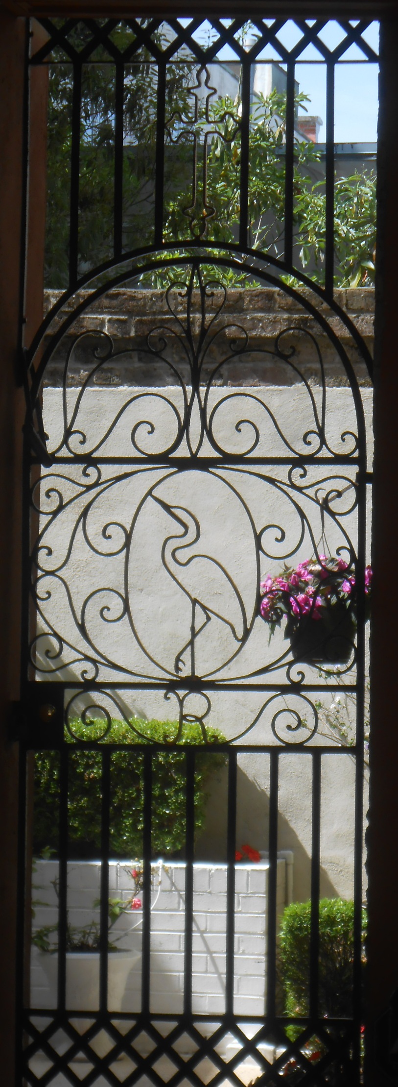
| | | | I can't help but admire the variety of imagery that the human mind is capable of to express similar ideas. But I have to speculate here. Where could these expressions have come from? My guess is that these idioms are similar to loan translations of a word or phrase, as above. This is probably the phrasing for these thoughts of various African languages that Gullah has recycled within an English framework. | | | | Day 10 (later): The Gullah Tour I do not suffer tours gladly. I usually know what I want to see, and its background, and can show myself around quite well, thank you. As a matter of fact, that's just what I was planning to do after the Gullah tour, and had a walking itinerary all set. But I was intrigued by the Gullah aspect of this tour (http://gullahtours.com/) and had signed on. It's run by a licensed guide with a Master's degree named Alphonso Brown who speaks both Gullah and standard English. Instructions were to meet behind the Visitor Center in the bus shed, which was a large, roofed-over, light and airy structure open at both ends, a very good way to accommodate numerous tour buses and keep them from parking on the street. Alphonso showed up on his 21-passenger bus, and, while it seemed that more than half the passengers exiting from the morning trip were black, it also seemed that more than half getting on were white, so the concept seems to have balanced appeal. | | | | The tour lasted about two hours, and, as expected went to places around town I'd be walking to afterward including the Porgy & Bess-related site. But Alphonso did put a Gullah edge to things telling anecdotes and telling about and demonstrating the language. The main thing he did that I wouldn't have otherwise been aware of was to tell about Philip Simmons and to pause frequently around town to demonstrate his ironwork. The only stop we made where we all got out of the bus was at the modest house where Simmons lived, run as a small museum by his family. | | | | I now know that Philip Simmons (1912-2009—age 97) was an artisan and blacksmith specializing in the craft of ironwork, and focusing on decorative ironwork. His life and career were long enough so that, when he started out, blacksmiths were still making practical, everyday objects such as horseshoes, but later on, the craft had become more of an art form rather than a practical profession. Examples of Simmons's work, to a large extent decorative wrought-iron gates, are located around Charleston and throughout the Lowcountry. Those were the stops that Alphonso had us take a peek at. This is the Philip Simmons Egret Gate (Photo by ProfReader) at 2 St Michael's Alley, in the South of Broad neighborhood. Click to inspect the egret more closely.
https://photos.smugmug.com/TheCarolinas/Charleston-SC/i-QSzpVXP/0/L/DSC_1303-Edit-L.jpg
| | | | These are the Double Heart Gates in the Philip Simmons Garden of St John's Reformed Episcopal Church, one block south of the Emanuel Church, on Anson Street, not far from we'd been walking this morning in Ansonborough. I understand Simmons has received many awards, that his pieces are displayed at the Smithsonian, as well as at the South Carolina State Museum and, reportedly, even in Paris and in China. | | | | Finally, we have a YouTube video of Alphonso Brown and others giving examples and discussing Gullah (2:02). The examples he gives are, unfortunately, overly complicated, but you can get the flavoring of Gullah. And as we got off the bus back at the bus shed, rest assured that he said on departing "Don' git los' now!" | | | | Charleston Walkabout After the tour, it was time for our planned walk around the historic district, specifically the two neighborhoods I find most compelling, South of Broad and the French Quarter, concentrating on the former city walls. Again we use the shuttle map to also show Charleston:
http://charleston.thedigitel.com/files/imagecache/image_470/wysiwyg_imageupload/1/carta-dash-map.jpg
| | | | We take the shuttle one last time, this time the green DASH shuttle from the Visitor Center down King Street, which is Charleston's main shopping street for high-end name-brand boutiques. After the shuttle turns onto Broad Street, we get off to see the Four Corners of Law at the intersection with Meeting Street, two main thoroughfares. As I found out at the time and can confirm now, it's much easier to see the architectural ensemble in an aerial view then on the ground, where it becomes dizzying trying to turn around to take in all four handsome buildings at once.
http://images.fineartamerica.com/images-medium-large-5/four-corners-of-law-vanessa-kauffmann.jpg
| | | | These are the Four Corners of Law, looking south on Meeting Street at Broad, in the direction we'll be headed in to visit the South of Broad neighborhood. The buildings are, clockwise from the upper left: the Georgian-style St Michael's Episcopal Church, 1761, representing ecclesiastical law; the Renaissance Revival US Post Office & Federal Courthouse, 1896, representing federal law; the Charleston County Courthouse, built in 1753 as the SC Provincial Capital, then rebuilt in 1792 and recycled as a courthouse, representing state law; and the Palladian-style Charleston City Hall, 1804, representing local municipal law. The curious name is commonly used to refer to this intersection, but it's not something of ancient provenance nor did it spontaneously develop locally. Believe it or not, the name was coined in the 1930s by Robert Ripley, creator of "Ripley's Believe it or Not", for use in his syndicated newspaper panel, and it stuck.
http://lindberglce.com/2012/0417_20_Charleston/net_115.jpg
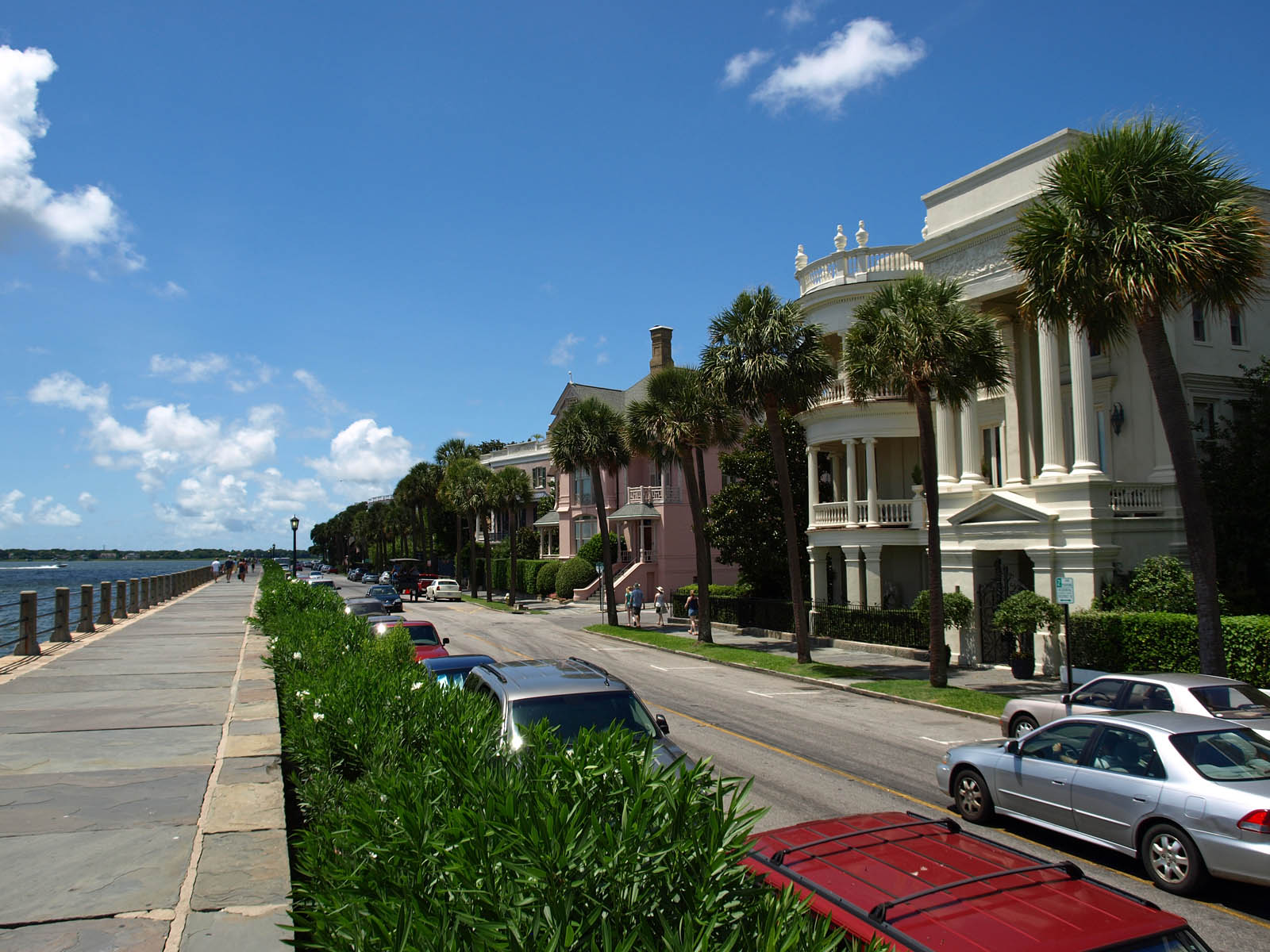
| | | | The one neighborhood whose borders are easy to find is South of Broad, which, as its name says, covers the peninsula south of Broad Street to the Battery. It's the wealthiest part of the peninsula and perhaps of all SC. While there are also some less upscale residences, rows of palatial antebellum mansions line Meeting Street and the Battery, including the street called South Battery facing White Point Gardens continuing into the street called East Battery, a southern extension of East Bay Street. | | | | Named for a Civil War coastal defense artillery battery at the site, The Battery today is a landmark seawall and promenade. The area of the Battery covers the eastern end of the South of Broad neighborhood, and is its most interesting part. The higher part of the promenade runs along East Battery and is known as High Battery and the part along Murray Boulevard is known as Low Battery. The point at the tip of the peninsula was originally called Oyster Point and is now more often called White Point, but both names reflect the fact that back in the day, piles of bleached oyster shells could be found here. The point gives its name to the public park here, White Point Garden (usually singular, not plural as on the map). In popular speech and elsewhere, The Battery and White Point Garden are sometimes referred to as "Battery Park", as in New York City, but the park and seawall promenade are not regarded by Charleston as a single entity, and that term is not an official designation. | | | | We enter the park at Meeting Street and turn left down the central walkway of White Point Garden (Photo by Brian Stansberry) to the intersection with Church Street (see map). Here we come to the Fort Moultrie Monument (click), often called the Sergeant Jasper Monument, since it shows a statue of Sergeant William Jasper of flag-raising fame as described in the last posting. A right turn at the statue gets us onto Murray Boulevard, the Low Battery, and we turn the corner at Oyster (White) Point and find ourselves up on the promenade along the High Battery (Photo by Billy Hathorn), here looking back toward the Point. You can note the height of the seawall the promenade is on by comparing the height of the cars parked on East Battery.
| | | | One of the better-known mansions is along here, the Edmonston-Alston House, at 21 East Battery, just south of Atlantic Street, built from 1820 to 1828 (Photo by DXR). You'll notice it's almost a classic example of a single house, with three window bays on the street and three piazzas on the side. The only single-house quirk that's missing is the faux door to the lower piazza, since entry to the side door seems to be via the garden. After reading and apparently enjoying, the first posting on Charleston, my nephew-in-law from Florida Dan has written me that he and his wife will be staying here with friends in December at a private facility on the grounds of the historic building. It's called the 21 East Battery B&B and has been established in the former Carriage House or Servants' Quarters. | | | | Walking further, then looking back at the Point again gives us this view of East Battery (Photo by Spyder_Monkey). That columned building on the right is another historic mansion. It's 29 East Battery (right façade) at Atlantic Street (left façade) (Photo by Evan Schmidt/Diligent Terrier). Right after Atlantic is Water Street, where we pass the point where the walls used to be. From here to Broad, we're in the southern half of the now former walled city. Hold onto this map, as we'll discuss the walls in a moment.
| | | | While we want to stay on East Bay, we'll take a short diversion for a moment and turn left on Tradd Street. The first thing we notice is the unusual house numbers. On our left, the first address is 0 Tradd Street, and I know of at least one other Charleston address using zero. On the right, the first house is ½ Tradd, and the second is 1 Tradd. Every once in a while elsewhere you can find an address like 22½, so that's not so unusual, but to have the first house on the street using a naked ½ I find a bit odd. | | | | A little further we go right on Church Street to some pleasant, but unprepossessing houses on the west side of the street at 89 and 91 Church. They are typical of the charming 18C architecture of the neighborhood, each one three stories high, with an arch on the street leading to a corridor and courtyard, which one can peek into. Pleasant as they are, they don't at first especially significant, although they have been restored, to wit:
http://cdn.shopify.com/s/files/1/0200/4808/files/354.jpg?256
http://mnocherphotography.ifp3.com/assets/mnocherphotography/800/Catfish%20Row.jpg
| | | | The archival photo shows the arch, and how elegant 18C townhouses had declined to a slum by the early 20C. But they are now restored, as shown by the second photo, centered on the brick archway. And the little sign gives away why we are here. We're at Cabbage Row, fictionalized as Catfish Row in Porgy and Bess. | | | | The two buildings had become a tenement housing up to ten families at a time, mostly the African-American families of freed slaves. This was the general situation up into the 1920s in the slum neighborhood of Church and East Bay Streets, where many residents sold produce on the streets. In these two buildings, many had used the courtyard to grow cabbage, and they would sell heads of cabbage to passers-by right from their window sills and doorsteps on the street. Although two buildings don't constitute much of a row, they nevertheless gained the sobriquet Cabbage Row. A person known to frequent Cabbage Row was Sammy Smalls, a disabled black fish vendor who drove a goat-drawn cart and knew his way around a gun and a knife. | | | | Just down Church Street from Cabbage Row lived DuBose Heyward. Born in Charleston, he was a descendant of Thomas Heyward Jr, a SC signer of the Declaration of Independence, but despite being a descendant of planter aristocracy, the aspiring writer was reduced to selling insurance. For inspiration, he took Cabbage Row and Sammy Smalls as the basis for a novel. He transported Cabbage Row from Church Street over to the Charleston waterfront, not more than a block or so away, and created a highly sanitized and romanticized version of Sammy Smalls as his protagonist. He then used imagery based on water, giving Cabbage Row the fictional name Catfish Row, and his protagonist the name of a fish, Porgy. Thus Heyward created a fictionalized glimpse of black life in Charleston during the 1920s. | | | | His 1925 novel was named after his protagonist, Porgy. His wife Dorothy then adapted it to a 1927 play, with the same one-word name, which was a considerable success on Broadway. He then famously collaborated with George Gershwin to adapt the play to an opera, referred to as a folk opera. We'll be needing our Greater Charleston Map shortly anyway, so let's look at it now:
https://www.charlestonsfinest.com/images/ca2009map.jpg
| | | | Look south of Charleston into the Lowcountry to the sea island we referred to in the last posting, James Island, and then beyond that to Folly Island (not named), the location of Folly Beach. Heyward rented a house on Folly Beach for George Gershwin. From there, both of them ventured by boat to the isolated sea island religious services in black churches for inspiration. The result was the 1935 opera, now with the longer name Porgy and Bess. It was based more on the play, using large sections of dialog as recitatives in the opera, and both were very similar to each other and followed the original novel less. Although the opera was originally less-well received than the play had been, it's the version that has become a classic. Here's a YouTube video of a medley (3:53) from Porgy and Bess as presented on the 2012 Tony Awards. | | | | Back to Church Street. After its tenement period, Cabbage Row was restored, and has since housed boutique-type shops. Alphonso had driven past it because of its black heritage, but said only a few words about it. As we stand here, we realize that actually, nothing really happened here. So why is it so much fun to visit? I suppose we can give the same answer we gave at Fort Moultrie, where the original fort is gone and you're only standing on the lawn, which was the former beach, and reading the historical display. History lives on in the mind, and when the physical location is lacking, just being there suffices, since enjoying history is really an internal experience. | | | | I am not a Latinist, and know very little about it. But I do know enough to put together a phrase that indicates a prime pleasure of travel: HIC LOCUS EST. When you arrive at a destination, it's a great feeling to know that THIS IS THE SPOT where something of note occurred. | | | | From here, we backtrack on Tradd to East Bay Street and turn left to find, on the west side of the street just north of Tradd, the iconic buildings known as Rainbow Row, which impress us for two reasons. Located from 83 to 107 East Bay, Rainbow Row (Photo by Something Original) is the longest intact cluster of Georgian row houses in the US, the earliest one dating to 1680. There are thirteen houses in this extended row, most of them mid-18C. The "rainbow" part of the name comes from the selection of pastel colors used for them when they were restored in the 1930s and 1940s. Rainbow Row is a popular attraction for visitors and is highly photographed.
http://boomstatic.com/content/tenant/cassinagroup/cms/images/French%20Quarter%20snip.JPG
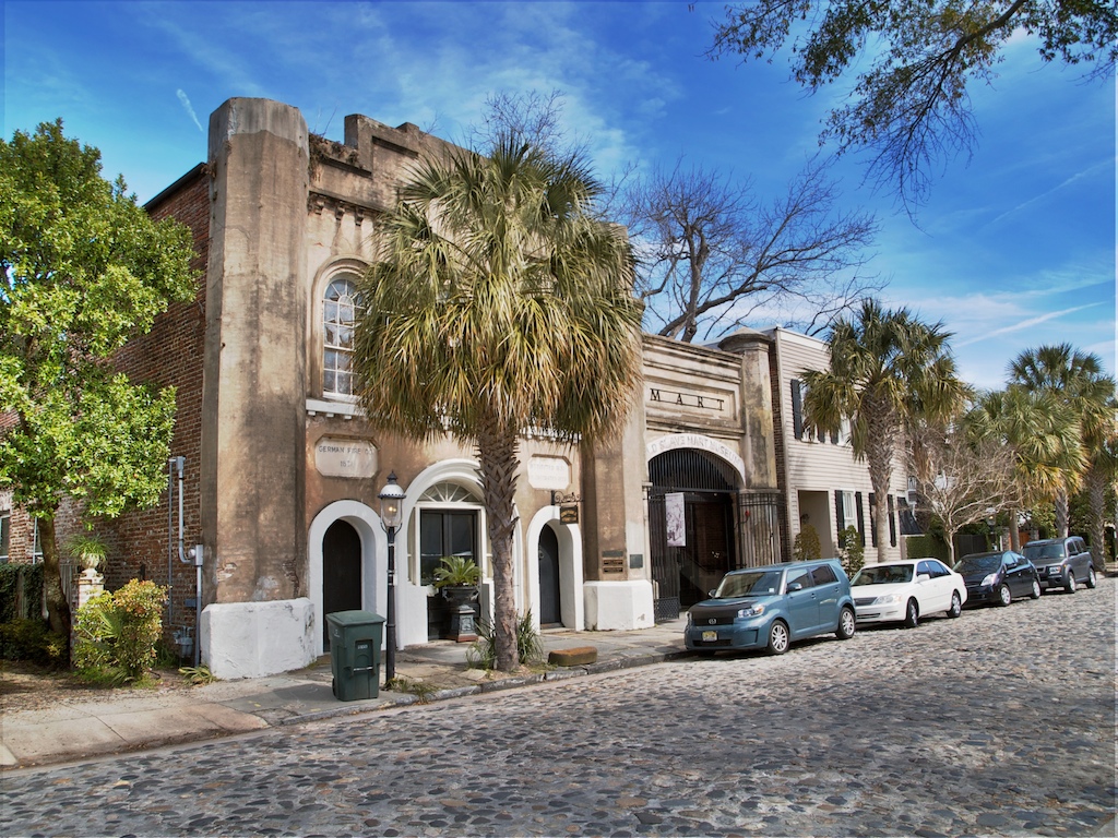
| | | | Once we cross Broad Street, we're in Charleston's French Quarter. Three of this neighborhood's borders are pretty much set: Meeting Street to the river, north of Broad. It's the northern limit that varies. This map shows the definition I like, with Cumberland Street being the north border, because that makes the French Quarter fit exactly into the northern half of the former walled city. Other definitions stretch the northern border to the City Market on Market Street, and even beyond into Ansonborough, but I'm most satisfied with this map's definition. | | | | Don't get carried away with the name. I love the area, but the name was conjured up only in 1973, I'm certain promotionally, when preservation efforts were being made to give the area some definition. It certainly seems to have used the French Quarter in New Orleans as a model for a name, but in Nola a French community had existed for centuries, whereas in Charleston, the name supposedly reflects the high concentration of French merchants in the area's commercial history. I'm good with the name, and the neighborhood has been added to the National Register of Historic Places. | | | | For local color, let's cut over to Chalmers Street, one block north of Broad (see map). One indication of its age is that it doesn't go further west than Meeting Street, where the wall was, so it had been entirely enclosed within the walled city. Here is a cobblestone stretch of Chalmers Street (Photo by Brian Stansberry), and befitting the age of the street, the oldest residence in Charleston is located east of Church Street at 17 Chalmers on the south side, the Pink House (Photo by Brian Stansberry). It was built between 1694 and 1712 of pinkish Bermuda stone, presently houses (click) an art gallery, and—should you be interested—it was for sale.
| | | | Across from the Pink House, and a bit further east at 6 Chalmers, was the museum that houses the Old Slave Mart (Photo by Benjamin Dahlhoff). Built in 1859, slave auctions were held here until about 1863, and the market also sold real estate and stock. When Union forces occupied Charleston in February 1865, the enslaved people still imprisoned here were freed and the market was closed. The building became a tenement, and in the 1920s it was a car dealership. It became a museum in 1938. I was not interested in visiting the museum, but found a nice bench outside the entryway (Photo by Brian Stansberry) that benefited from air-conditioning escaping to cool down before dinner. I then went to explore the shops and restaurants on busy East Bay Street itself, before going to dinner at an outstanding restaurant I'd discovered (to be discussed separately shortly).
| | | | A walk along Cumberland Street brought me right back to my hotel on Meeting and Cumberland, but along the way was another discovery, and I now see it shows up on our map of the French Quarter. Along the south side at 79 Cumberland, just east of Church is the Old Powder Magazine (Photo by Brian Stansberry) that served the original fortifications of the walled city. It was completed in 1713, which makes it the oldest surviving public building in what had been the Province of Carolina. (The Pink House was a private residence and was completed the year before.) It later saw other uses, and is a landmarked museum today. Its location means it faced the former city wall across Cumberland Street, which is another reason why I like to consider that street the northern border of the French Quarter. | | | | The Former Walled City Talking about the wall, in the last posting we said: There were very few fortress cities in North America—I can think of only Spanish St Augustine and French Québec (2013/5)—and Charles Towne/Charleston was to be the only English walled city. As streets were being laid out, a formal fortification plan was developed by 1697 and overlaid on the developing street grid. I'm delighted to say we are now ready to see how yesterday lives on into today in the streets we've been walking on for the last while.
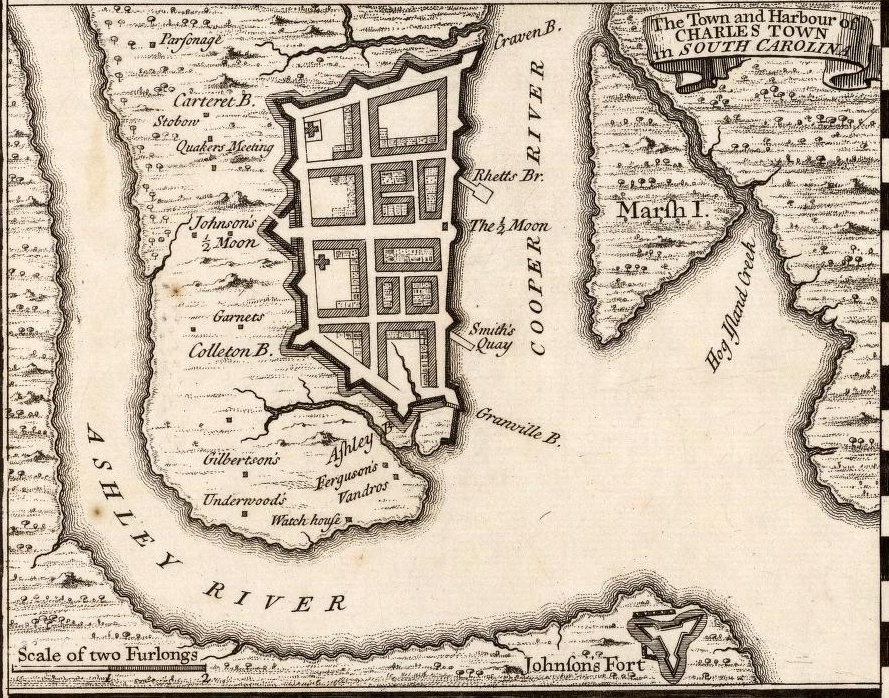
https://walledcity.files.wordpress.com/2008/04/1711_crisp_detail.jpg
| | | | I have two maps of the walled city, the one we used last time and this one. This one is older, showing the status as of 1711, and prettier because of the colors. Unfortunately, it's turned on its side, with north to the right. Click to enlarge it, and you can read on the left the list of bastions, bridges, churches, and more. We'll comment on just a couple as we go along. | | | | | | On the lower right is a distance scale of the era showing "80 Perches or 2 Furlongs". In 2011/20, when in Salem MA, we said: The rod (or perch) was a unit of length equal to 5.5 yards (16.5 ft) or 5.0292 meters. I now find that a furlong = 1/8 of a mile = 660 feet = 220 yards = 40 rods = 10 chains. (Easiest is getting meters out of yards: 220 yards = 201 meters.) Thus "80 Perches or 2 Furlongs" are 402 m (1,320 ft). |
| | | | The river side was the most exposed side, vulnerable to a naval attack, but it was also the commercial hub of town with the most valuable real estate. This side necessarily had simpler fortifications in the form of a substantial brick seawall about 1.8 m (6 ft) wide at the base. On the outside, it rose about 4.6 m (15 ft) above low water, and on the inside, it was about 1.5 m (5 ft) above street level. | | | | A half-moon battery is a semicircular fortification, and there was a brick one (G on the map) in the center of the seawall. It protected the river approach and served as a formal entrance to the town. This detailed information was gained from archeological excavations, but no similar information has become available about the three primary walls about town other than what appears on the maps. However, the entire run of fortifications extended approximately 2.4 km (1.5 mi). | | | | Opposite the half moon battery on the water side is a corresponding protective structure on the inland side. Connected by two draw bridges (H & K) is "Ionsons cover'd Half Moon" (I) protecting land approaches. #8 seems to be a private residence, but right in that area is where the Powder Magazine was that we saw. And M, "The Creek on both ſides" points out the obvious fact that the location along the Cooper River was delineated by two natural creeks, Vanderhorst Creek in the south and Daniel's Creek in the north. The location of the creeks had the affect of giving the city walls the form, not of a rectangle, but of a trapezoid (US & Canadian English, trapezium in English elsewhere). | | | | As Charles Towne yielded to pressures to expand, the three main walls were dismantled by the 1730s, meaning they lasted only just over three decades. The harborside fortifications lasted longer, into the 1780s, but were gone by the 1790s. | | | | | | Before leaving this map, we should mention again two things we've talked about in the past, since they're demonstrated so nicely here. The Long S is discussed completely in 2011/22, namely that it was used, not only on this map in the 18C but even into some of the 19C, as an alternative to the lower-case S we use today. The latter at that time was called final S and used only at the end of words. Initial and medial S appeared as ſ. Along with some spellings we don't use today (Explaination), we see on the table Aſhley Baſtion and Palliſades (today Palisades), showing both S's in one word.
In 2008/17 there is, I think a nice definition of "ye" as opposed to the other "ye", two entirely different archaic terms spelled alike. If you're curious about the difficult one, read the paragraph in that posting. For an overly simplified explanation, we'll offer this. The easier "ye" is an archaic variation of "you" as in "what say ye" and offers no problem. The more confusing one involves an old spelling for the TH in "this". That spelling was Y. On that basis, the very familiar word "the" was spelled "ye". Someone wanting a little more flair might write it with a superscript E as "ye", or might even put the E above the Y, which I cannot duplicate here. Another way of looking at it is that, just as an ampersand (&) is a symbol that can be used to represent the word "and", ye was a symbol that could be used represented the word "the". Unfortunately, it looks just like the other "ye".
In that earlier posting, we used four lines of mid-16C poet Robert Herrick as an illustration for this. Here I'll repeat just the first line, and the most famous:
Gather ye rosebuds while ye may . . . Gather the rosebuds while you may . . .
The uninitiated will misread the beginning of the line on the left and say "ye" instead of "the". On the right, both archaicisms are removed. Unfortunately, for the sake of clarity, the historic flavor is also lost.
|
| | | | You'll note on the table of our map that the word "the" is used numerous times as is, while ye comes up only twice, and each time where the entry is long and space is at a premium. K is "the Draw Bridg [sic] in ye Half Moon" and H is "the Draw Bridge in ye Line", with "in" entered as an afterthought. | | | | I suppose we have to deal with the commercial abomination in the style: Ye Olde Xxxx Shoppe. I was surprised to find the Online Etymology Dictionary actually gave "shoppe" a reprieve. It's not made-up nonsense, but was one of several Middle English variations of "shop", and actually appears in Chaucer. But it adds that as of 1918 it became an affectation of US commercial establishments. However, it trashes "olde"—thank goodness—as a pseudo-archaic, mock-antique variant, and points out that the "Ye Olde" construction was already being mocked by 1896. We may continue to mock it, but it's apparently here to stay, and that would have to be with this particular "ye" rhyming with the other "ye". You can't win 'em all.
http://www.spencerartgallery.com/w-images/spencermap4.jpg
| | | | This contemporary map will help us make comparisons between the walled city and today's Charleston. Keep it for now in another window. It shows the area we've just been walking through, the Battery area of South of Broad and the French Quarter, but all in one map. We'll now look again at the historic map we used in the last posting, which is also oriented north-south, as the modern map is, for easier comparison of streets. This is that 1733 map. | | | | Now compare locations on the old map to the new map as follows: We recognize the street running inside the seawall as East Bay Street, realizing that any extensions beyond the former seawall as being landfill that was later built upon. The street just inside the west wall has to be Meeting Street, and we now confirm why these are the two main N-S streets in the modern city, since extended in both directions beyond the walls. In between must then be Church Street. | | | | Of the cross streets, right in the middle, connecting the two Half-Moon Batteries, is Broad Street, since extended west across the peninsula. We again see the reason for its importance, originally connecting the water and land entrances to the walled city. We also note that the intersection of Broad and Meeting, once a main bastion and the land entrance to the city, is now the site of the Four Corners of Law. | | | | South of Broad is Tradd Street, and south of that is Water Street, which to this day runs at an angle to the others, based on the now disappeared wall. We also see why the wall was at an angle, since it ran along the now equally disappeared Vanderhorst Creek, and we also see where Water Street gets its name. | | | | North of Broad Street we can make out Queen Street and Cumberland Street, which is just inside the north wall, whose location is also determined by the now disappeared Daniel's Creek. And now we finally get our answer to the question about why City Market is located where it is, and why it runs from Meeting all the way to East Bay—the market covers over the site of Daniel's Creek, the former shores of which are now apparently South Market Street and North Market Street. | | | | On the older map, we see that this street grid broke up the area into eight large blocks, but that two of them were subdivided from the beginning. Not surprisingly, they seem to reflect additional business along the very central Broad Street, particularly right at the water entrance to the city. Some of the small streets within these two blocks seem also to have been extended, which accounts for State Street on the modern map being extended north, and also for our recently visited Chalmers Street (not named on the map, but just south of Queen and starting at State) being extended west. | | | | We discussed the bastions in the previous posting, but now I'd like to point out something that, once I realized it, was a great pleasure. The intersection of Meeting and Cumberland indicates to this day the NW corner of the walled city, which was the site of Carteret Bastion, named after Sir George Carteret, one of the Lords Proprietor. My humble motel was at the NW corner of this intersection, meaning I slept right at the site of this historic bastion, and that walking down Cumberland from the restaurant both nights meant I was walking right on the inside of the former wall. | | | | Slightly North of Broad I hadn't checked out Charleston restaurants in advance, but when Alphonso on the tour paused outside one on East Bay Street and talked about it positively for a bit, I decided that it was the one to try. It might have been the wisest ad hoc decision I made on the trip, and dined there both nights of the two full days in Charleston. | | | | As to location, like many businesses in East Bay Street, it's in a former warehouse on the east side, toward the river, and is just south of Cumberland, making it particularly convenient. But even if it weren't a great restaurant, its name alone would keep it in the forefront of your mind, since it contains a double, self-teasing joke. The name makes reference to the fact that the lah-de-dah South of Broad neighborhood is only about two blocks away, and it jokingly implies it can be just as pretentious, so it calls itself Slightly North of Broad. While that's quite a bit of fun, the second part of the joke is the acronym of the restaurant is SNOB (thrice indicated on below picture). Once you catch on, you can't help but enter the restaurant with a smile on your face and a positive attitude.
http://cdn.iowagirleats.com/wp-content/uploads/2013/04/SNOB_01_mini.jpg
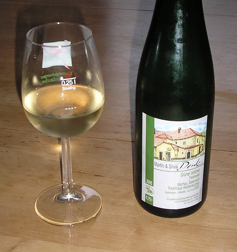
| | | | It was 5 PM, early for dinner, and they had just opened for the evening. Still, they were packed, but she found me a table in the bar area near the door, and I was glad to get it. I sat at the pair of windows just to the right of the entry in the above picture. They describe themselves as "an eclectic Lowcountry bistro", and I find that quite accurate. During the meal, the manager stopped by to chat. Managers often might do that in fine restaurants, but I suspect that sometimes they note a solo diner and pay even extra attention. She and I had a pleasant chat. | | | | There are only two wines that I take particular note of, and we discussed the Italian wine Vernaccia in the last posting. The Austrian wine Grüner Veltliner--felt.LIN.er--(Photo by Mussklprozz) is the other one I particularly like, and is also white, as indicated by the name, since grün is "green", indicating the greenish overtones on the white grape. It's more frequently found on restaurant wine lists than Vernaccia, though not by any means commonly so. But SNOB had it, and by the glass, so that was a positive step. Though an Austrian wine, I think I had a Grüner Veltliner from California. | | | | | | The wine in the picture is a Grüner Veltliner from Weißenkirchen in der Wachau, which I would have passed years ago when we took a day cruise on the Danube. The Wachau--va.KHAU, rhymes with "now"--is the picturesque valley of the Danube as it passes from Melk down to Dürnstein and Krems, with Weißenkirchen just upstream of Dürnstein (Map & Photo by © Bwag/Wikimedia). Click to inspect the vineyards coming right to the edge of town, as well as the Danube sightseeing boat of the type we would have been on. This is a closer view (click) of Wachau vineyards surrounding an estate in the same area (Photo by jay8085). Grüner Veltliner accounts for a third of all the vineyards in Austria. It's also widely found in the Czech Republic, the US, and South Australia. |
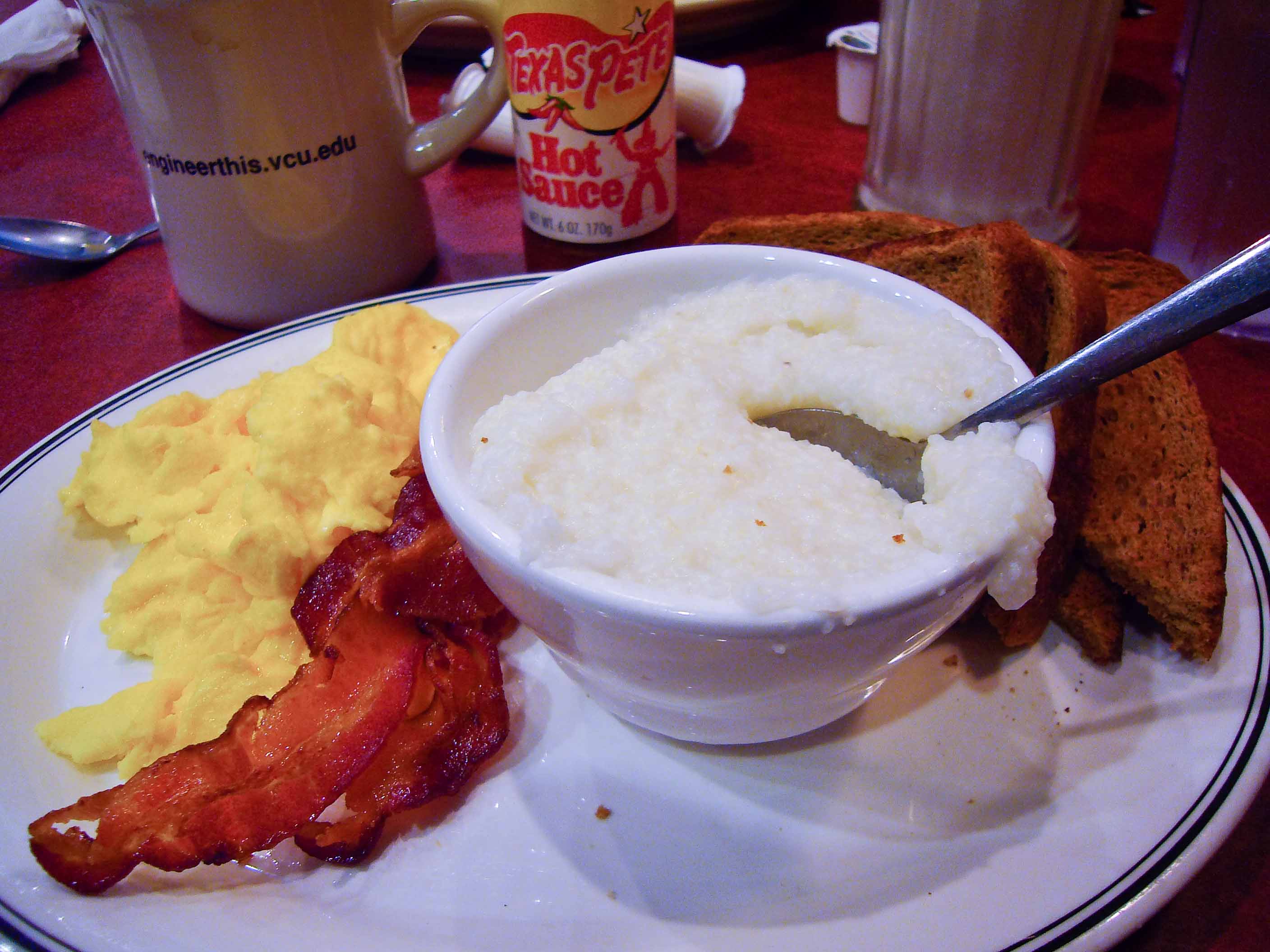
| | | | I started out with a squash bisque—I love any bisque, and I'd never had one with squash before. For a main course, I'd only recently heard about the Lowcountry specialty of shrimp and grits, and it seems to be a specialty of SNOB, since the menu varies frequently, yet this dish seems to be a regular. I suppose you could call it a soup-like stew with shrimp. The waiter had to advise me that the grits are on the bottom, so you should dig deep to get a good mix. The variation at SNOB includes country ham and sausage, but the waiter told me that the sausage was slices of Polish kielbasa, so I see why SNOB calls itself eclectic. This is shrimp and grits as served at SNOB:
http://s3.amazonaws.com/foodspotting-ec2/reviews/862682/thumb_600.jpg?1315794019
| | | | Grits, Groats, Grütze I am in sore need of digressing here to learn more about some foods, and to solve a mystery. It starts with the very grits we've been talking about. I've loved them for years, yet didn't know just what I was eating. | | | | To understand what grits are, we have to revert to the full name, hominy grits, to realize that grits are based on hominy. Hominy in turn is made from dried kernels of field corn (maize) that have been treated by being soaked and cooked with an alkali, such as a dilute lye solution, in order to break down the structure of the corn kernels. They're then dried and ground into a flour. This can be made into tortillas, since hominy is a staple of Mexico and Central America. | | | | Native Americans also made hominy, which was then ground on a stone mill. The ground hominy was then passed through screens. The finer material that passed through the screens was used as grit meal, and the coarser material that did not pass through was grits. In other words, hominy grits are the coarser ("grittier") remnant of ground hominy. Grits are prepared by boiling in salted water. They can be served with every meal, although they're particularly popular as a side dish for breakfast. They are a signature dish of the US South, where three-quarters of the grits sold in the US are sold. These are buttered grits with waffles (Photo by Ernesto Andrade), and this is a breakfast of eggs, bacon, toast, and grits (Photo by sashafatcat). My personal preference for grits at breakfast, once learned from fellow travelers from the South: hot grits with a pat of butter and maple syrup, in other words, grits treated just like waffles or pancakes. | | | | | | Sources point out, and I fully accept, that the word "grits" acts either as a singular or plural, such as in "Grits is a Southern dish" or "Grits are made from corn". Still, the former is more homey and colloquial. Beyond what I've read, I'll add that the pronoun is always plural, such as in "Grits? I love 'em". You can never use "it" there. |
| | | | There are other related foods here, such as polenta, but I'd like to mention groats.
Groats are the whole-grain, hulled kernels of various cereal grains such as oat, wheat, rye and barley, or of seeds, such as buckwheat. "Whole grain" means that the germ and bran portions of the grain are kept, and not removed as happens during milling. Buckwheat groats are particularly well-known in English, and are the basis of kasha, an Eastern European staple. However, in Poland, Ukraine, and Russia, kasha can be made of other grains. This is kasha, roasted buckwheat groats, cooked (Photo by FakirNL). It's sometimes translated as buckwheat porridge. I have eaten it, and as much as I'd like to remain true to my Russian heritage on my mother's side, I find it on a par with cooked, roasted sawdust.
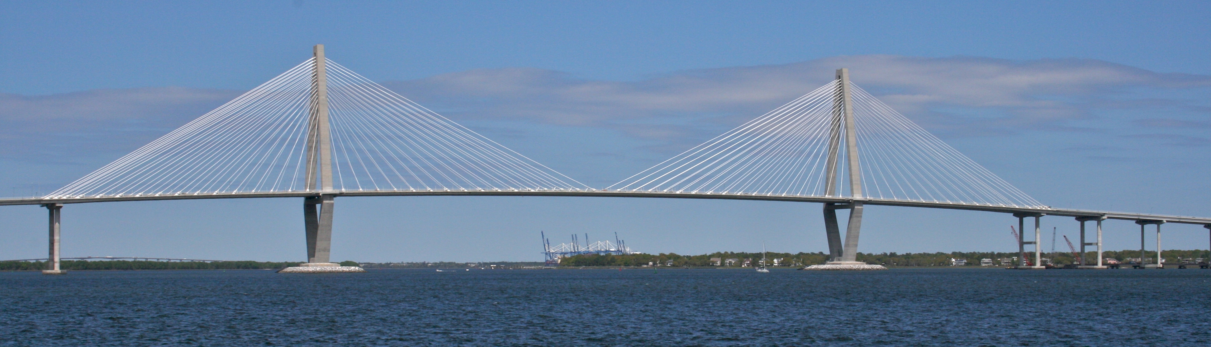
| | | | The last item in the heading Grits, Groats, Grütze might not seem to belong here, which is just why it needs to be discussed, as it involves a mystery to me. There is an absolutely delightful dessert native to (North) Germany and Denmark, which I choose to translate as "red berry pudding", often served topped with fresh cream, vanilla sauce, or whipped cream. But it's its name that bothers me. Try to avoid it as you may, the German name Rote Grütze, literally means "Red Groats", and that is NOT what it is. It's the same with the Danish name (below). | | | | So we plunge into some research. Red berries are the most frequently used, so that explains the first word--using berries of other colors, such as yellow or green, will alter the name. But along with other ingredients, a thickening agent is needed, such as (corn)starch. Apparently, at one time, groats were involved as a thickening agent for Rote Grütze, here served with fresh cream (Photo by Parzi), but that's no longer the case. On the other hand, it may also be that groats can be referred to as a porridge, and a pudding is porridge-like. | | | | The Danish name is rødgrød; add fresh cream and it's rødgrød med fløde. This latter phrase is also used in Danish as a shibboleth to tell if a person is a native speaker or not. I can conquer two out of the three difficulties: (1) all three Øs are like Ö, the first two are short, the third one long; (2) all three Ds are like TH in "this"; (3) but I can only mediocrely pronounce—if at all--the Danish stød, a throaty, unwritten sound in all three main syllables. I also understand that the stød can be realized as a glottal stop, the more common throaty sound, also unwritten, that starts each syllable in "Uh-oh!". Friend Allan has studied Danish and says he can manage the stød. Well, I can keep on trying. | | | | There is online a large selection of YouTube videos with people having fun with this Danish phrase, and we'll show two. First is a short (0:11) video of someone, likely a native speaker of Danish, who can demonstrate it well. I find particularly noticeable the three times D sounds like a voiced TH. Second is a 0:45 video at the Danish Embassy in Bangkok, where several Thai employees try to say rødgrød med fløde. Uh-oh. | | | | Day 11: Charleston 2 For the second of our two full days in Charleston we had arranged with Enterprise for a car, free on their points, and reconfirmed our morning pickup the day before. On arrival, instead of the compact car I always reserve, all she had was a van, so it was quite an upward hoist each time to get in the driver's seat, and I had enough capacity in the back to transport quite a number of invisible friends. | | | | Look back at our Greater Charleston map to see our route for the day. This is when we went to Sullivan's Island to visit Fort Moultrie, described in advance in the last posting to keep it in chronological order, and to do so, we had a pleasant surprise on the way. We knew we had to go over a bridge, but didn't realize how nice a bridge it would be. Find the Ravenel Bridge on the map, and then click to admire this panorama of the Arthur Ravenel Jr Bridge (Photo by Ron Cogswell) across the Cooper River. It opened in 2005 with eight traffic lanes and a lane for pedestrian and bikes, and has a main span of 471 m (1,546 ft), making it the third-longest cable-stayed bridge in the Western Hemisphere. This is a closeup (click) of the center span (Photo by bbatsell). | | | | We discussed cable-stayed bridges on the Mississippi, such as the Clark Bridge in Alton (2015/20). One possibility is a fan design, as in the Clark Bridge, which results from all the cables going over the very top of the tower. The more-easily constructed type is the harp design, where the cables instead pass individually through a series of openings down the upper side of the tower, as with the Ravenel Bridge (Photo by Ted[bobosh_t]). | | | | Coming back over the bridge, we pass through the peninsula (see map), cross the Ashley, and head northwest up SC Highway 61. We are coming this way to see nothing at all, actually a move that turned out to be a very wise decision. This needs explanation. | | | | This area is referred to as the Ashley River Corridor. In colonial times, it was the river that served as the main route to the stately plantations facing it on its south bank. Behind the plantations, what had been a Cherokee trail did serve as land access to the plantations, but it was an arduous back road. That road today is SC 61, also known as Ashley River Road. | | | | The Ashley River Corridor is also referred to as the Ashley River Plantation District, principally because of the three plantations along the road and river. On the route, first comes Drayton Hall, 1742, which is the only one to survive both the Revolutionary War and Civil War intact. It was occupied by seven generations of Draytons, wealthy English planters who came from Barbados in the 17C. Next comes Magnolia Plantation & Gardens, and finally Middleton Place, dating from 1741. Michelin gives Magnolia one star, the other two get two stars, and both of those are National Historic Landmarks. Many of the plantations along the Ashley River were occupied by British forces between 1780 and 1782 during their occupation of Charleston. | | | | However, I came here to see none of these, as I am "plantationed out". I've visited numerous plantations in Plantation Alley and St Francisville in Louisiana, several in Natchez and Vicksburg, Mississippi, and stayed overnight in both Madewood and Nottoway. I had no inclination to also visit these, praiseworthy as they may be—and none got three stars anyway. Nor had I put aside time to do so, and their house-and-garden entry fees are very high, $22-23-28, respectively. But I thought that driving up the country road in their neighborhood might be a pleasant experience, since I had the car, anyway. | | | | What might have been a dumb thought turned out to be a smart idea. It was a fun drive, and after the fact, I found out that the plantation section of Ashley River Road is itself on the National Register of Historic Places, and, along with the three plantations, is part of the Ashley River Historic District, which is itself also listed on the National Register of Historic Places.
http://s.hswstatic.com/gif/scenic-drive-in-south-carolina-ashley-river-road-ga-12.jpg
| | | | On our main map, find the part of Highway 61 beyond the intersection with I-526 and you can estimate on the small map above just where the historic section starts. It's like night and day. Ashley River Road starts out all billboards, gas stations, and other 21C detritus, and suddenly its four lanes narrow down to two tree-lined lanes, and one moves back several centuries within the historic, scenic stretch of many large oaks. Actually, it's to the point where one feels one shouldn't have rented a car but a horse-and-buggy instead, just to fit in to the ambiance. | | | | Ashley Barony was a huge land grant made to Anthony Ashley Cooper, the most influential of the Lords Proprietor, in 1675. It was an Act of the General Assembly in 1691 that authorized the construction of Ashley River Road along the Cherokee trail, with the intention of connecting Ashley Barony with Charleston, a project that wasn't completed until 1721. A statute that year prohibited the cutting of shade trees along the road, so it's possible that some of the trees date from then, if not earlier. Ashley River Road was declared a National Scenic Byway in 1999. It's likely the oldest road in South Carolina still in use. | | | | Thus the dumb move of going to "see nothing", just to travel an old road, turned out to be a clever move. We drove onto all three plantations, only seeing one house from a distance, but did come across a peacock strutting across a nearby lawn.
http://ashleyriverhistoriccorridor.org/wp-content/gallery/ashley-river-road/2-ashley-river-road.jpg
http://ashleyriverhistoriccorridor.org/wp-content/themes/ARHCtheme/PageElements/Ashley-River-Road.jpg
| | | | The first picture shows the typical overhanging trees along the landmarked stretch of Ashley River Road. It shows the pleasant, rural, quiet aspect of the road, although I would have not included the yellow traffic sign in the picture. I'm leery of including the second picture here. It's highly over-romanticized, approaching kitsch. Perhaps it was taken at sunset, which is not when I saw it, but it's too good a picture not to include, because it is charming and because of the Spanish moss hanging from the trees.
http://www.luxus.co.in/images/marina/CharlestonCityMarina1.jpg
https://photos.smugmug.com/CharlestonAerials/Historic-Charleston-SC/i-cCkHwGN/4/L/DSC_2980-L.jpg
| | | | On the Greater Charleston map you can see that there's a bridge further south back onto the peninsula, which leads to the Calhoun Street and its area. Crossing this bridge, it suddenly struck me, might get us close to the Charleston City Marina, where we'd be sailing from tomorrow, and the first picture above shows the view of the marina from the bridge. On a whim, I pulled over and with difficulty managed to find parking, in order to get a preview of tomorrow. Note the larger ship furthest out, on what turns out to be called the marina megadock. As the second picture shows even better, one hikes past dozens of smaller craft to get out there. Neither ship in these pictures was mine, but to my surprise, it turns out I did see the American Star. I didn't realize it had come in one night earlier to give the previous passengers a day in Charleston. I chatted with some ship employees, and had a better feeling of how things would go in the morning.
http://realdealwithneil.com/wp-content/uploads/2013/01/Harleston-Village-Neighborhood-Map.jpg
| | | | Rather than driving down Calhoun (see above map), it seemed more promising to drive into the local neighborhood, Harleston Village. It was middle-class, quiet, and residential, with many single houses. I drove down Wentworth, and at Coming, I came across the B&B I'd been considering, but which had been booked long in advance. It was charming, but I liked my central location more. | | | | As soon as I saw the name of this neighborhood, I sort of assumed some 20C realtor had picked a cutesy name to sell houses in a development. Take "Charleston", lop off the C and get Harleston? Really? Well, I'm glad I hadn't really believed that. The Village of Harleston was originally part of a land grant made in 1671-2. It was eventually inherited by one John Harleston (!!!!). This section bore the Harleston name when it was developed and streets were opened in 1770. The Harlestons, during the Colonial period, were active in the government of the Province. The neighborhood was not completely filled until the 20C due to swampy land and mill ponds, which further explains why the walled city had been founded on the Cooper side and not here on the Ashley side. | | | | But can you imagine him introducing himself as John Harleston from Charleston? Or present residents saying they're from Harleston in Charleston? Maybe that's why they inserted "Village" in the name. | | | | There was little left to do, so I drove around a bit, down Meeting to South of Broad and the Battery, then up the French Quarter, and finally parked the car at the hotel. Paying for one night's hotel parking and returning the car myself in the morning was worth it, rather than having to be picked up again, because then Enterprise could drop me off at the City Marina in the morning to board the American Star. | | | | It was still too early to go to dinner, so I walked back to and through the City Market for a second visit. Its far end brought me to East Bay again and to dinner at SNOB. I came back on Cumberland, which means I unwittingly circumnavigated the entire north side of the former walls.
http://www.charlestoncvb.com/assets/images/listings/original_http://www.charlestoncvb.com/assets/images/listings/original_mccradys1.jpg
| | | | Having made a reservation the night before, I got seating well within the main area of Slightly North of Broad (above). I believe I repeated the squash bisque, since it was really that good, but this time my main course was a pork chop with cabbage and diced roast potatoes, which I noted involved a wonderful blending of textures. I really had to smile when I saw on the wine list that they served, just like Filomena, Vernaccia di San Gimignano, and by the glass, so I didn't have to take half a bottle home with me. I suppose as far as wine goes this trip, my cup runneth over. (Not literally—it's too good to waste!) | | | | Afterward, I ordered their cheese board, usually preferable to some sweet dessert, and the manager stopped by again to chat. She said they had a fine Madeira, and suggested I order it with the cheese. I love Madeira, and discussed it when there (2012/8). They did serve an excellent one to go with the cheese and top off a fine meal. | | | |
| |
|
|
|

