|
Reflections 2016
Series 18
November 20
East Coast IX: Charleston Sailaway-Wilmington-Beaufort-Outer Banks-Kitty Hawk
| | American Cruise Lines I've had some experience on American Cruise Lines (ACL), but the two previous trips with them, also on the US East Coast, were well in the past. This is the trip they call today their "New England Islands Cruise":
http://userscontent2.emaze.com/images/12d18b4c-b4aa-4e2c-9d52-d67da103b280/87215127-4509-4360-824a-a08ba6e32557.jpg
| | | | On the 50 Voyages list (2013/7), Voyage 15 in 1984 was with ACL, but was slightly different from their present trip. What was then the "New England South Shore Cruise" included Connecticut instead of inland Rhode Island (which we visited privately at other times), leaving from East Haddam on the Connecticut River and crossing Long Island Sound.
http://www.premierrivercruises.com/assets/images/maps/acl/historic-south/ACL-m540-historicSouthGoldenIsles.jpg
| | | | A coastal trip more along the lines of the current one was our second ACL trip, Voyage 17 in 1988, called the "Intracoastal Waterway/Historic South Cruise", from Jacksonville to Charleston. It's similar to the current route above (some places named are, I'm sure, just suggestions), except that the intermediate stops were Fernandina Beach/Amelia Island, Brunswick, Savannah, Hilton Head, and Beaufort (BYU.fert). The highlight, other than Savannah and Charleston, was the charming Victorian town of Fernandina Beach FL, which we liked so much that some time later, we drove back and stayed in a Victorian B&B there. We just mentioned that enjoyable visit in 2016/11, discussing the former Florida Central and Peninsular Railroad across to Cedar Key, shortening a potential boat ride around all of Florida. But it's particularly important to note how the route on the Intracoastal Waterway (ICW) on this coastal sailing is quite unique, not going out into the ocean but almost always staying inside of the string of barrier islands, making the trip river-like. From the ship, looking off to the left was the mainland, but looking off to the right were barrier islands, sometimes with a view over them to the ocean, or at least through the periodic inlets. It was like being on a river, but also very different.
http://www.premierrivercruises.com/assets/images/maps/acl/coastal-southeast/ACL-m540-midAtlanticInlandPassage.jpg
| | | | This current voyage is the sail part of the Charleston Rail 'n' Sail. It's a repositioning cruise held twice a year. In the spring, when the three ACL ships have completed their winter schedule in the south and are ready to move north for the summer, they each do a single coastal trip from Charleston to Baltimore. In the fall, this is reversed. With good timing, this trip can also be combined with the Historic South trip to do a single voyage between Jacksonville and Baltimore, which they call the East Coast Inland Passage Cruise. Since I'd come northbound in 1988, I wanted to continue going in that same direction now, in what is called the Mid-Atlantic Inland Passage cruise. However, the intermediate stops on the above map are rather fanciful. The stops were actually Wilmington, Beaufort (BO.fert), and Kitty Hawk, all in NC, Norfolk VA, and St Michaels MD. | | | | Day 12: Charleston Sailaway After two full days in Charleston, it was the day of departure, the sailaway day. I'd kept the rental car for one night at the hotel, and drove to Enterprise to return it, and they then gave me a lift to the City Marina. The driver was a college kid who was majoring in international affairs, who'd studied Russian in St Petersburg and was planning to go back. When traveling, you come across the most interesting people where you least expect them. At the marina, I made my way to the megadock I'd discovered the day before and boarded the ship.
http://files.ctctcdn.com/8425d767001/8701e049-3b22-439a-ad5a-af6868b112b7.jpg
http://www.premierrivercruises.com/assets/images/deck-plans/ACL/ACL-dp-americanStar.jpg
| | | | The ACL ship was the American Star, pictured above, built in 2007. Two friends asked me after the trip how the boat ride was, and I honestly told them it was very enjoyable, and I'd recommend it to the general public. In addition to the many positives, that statement, however, will not prevent me from commenting on the negatives I perceived (I'm very picky). I have certain likes and dislikes, which probably don't apply to the general public. | | | | | | One point I've made before is my distaste for the word "cruise", which to me implies indolence, and which I try to avoid as often as possible. I list my "voyages" and above mentioned "boat ride". In addition, I'll say again that I'm a traveler, not a vacationer, primarily enjoying the travel route and secondarily the intermediate stops, along with the social interaction of the voyage. I would say that vacationers, of which there were many on board, would be more likely to call this boat ride a cruise. |
| | | | The American Star has three actual decks (see above deck plan). I say that because many if not most ships always like to maximize their presence by saying they have something similar to the Observation Deck (or Sun Deck) on top, with some chairs and an awning, and nice views, and that is totally true. What they fail to point out is that going upstairs to such a deck is really nothing more then going up to the roof of a building, which would hardly be counted as one of the building's floors. So instead, inspect the three actual decks, all of which included cabins. | | | | The Main Deck also had the entrance vestibule in the center and the dining room. There was no set seating, it was always catch-as-catch can. The food and service were excellent, and on occasion, you could order in advance off-menu. I did that for one lunch after I learned they had quinoa on board, and asked for a quinoa salad. | | | | The next deck up is the Lounge Deck, and the main lounge is at the bow. Lectures were held here, as well as a complimentary cocktail hour before dinner. That drinks were complimentary I found unusual, which was in addition to wine and beer being complimentary at lunch and dinner, anyway. I tried out some cocktails I hadn't had before, and even tried a single-malt scotch. I am not a scotch drinker, but had heard about single malts. I found it slightly more palatable than regular scotch, but it didn't change my mind about scotch. | | | | I only see here that, what I thought of as "my" deck or the top deck is technically called the Carolina Deck, which is news to me. The only single cabins are here, and I had 306. The captain was in the unnumbered cabin next to me, as the pilot house was adjacent. The room with full bath was quite comfortable. The balcony, which I really didn't need, was petite. As I do in such cases, I made it a point to step out on the balcony at the end of each day, just to tell myself I used it, but it really isn't necessary, as there are plenty of other places onboard to sit and see the views. | | | | The cabins were lacking phones, which I normally wouldn't need unless I wanted a wake-up call. In lieu of phones, there was a large panic button in case of emergencies, which probably reflected more the age of the passengers. There was theoretically WiFi everywhere, but tinny little modem they used didn’t penetrate the steel walls, so I was always going down midships on my deck, or sometimes below, to use the small lounge (see sketch) where the modem was actually located. It was a bit of an inconvenience, but manageable. | | | | I met some very nice people, but the median age seemed to be even higher than usual. There was also quite a degree of infirmity, including an electric wheelchair, a man dragging along an oxygen tank, and numerous walkers and canes. I joked I maybe should get a cane to try to fit in. But I admire the tenacity of people who say disability won't stop them from the pleasure of travel. | | | | I got to know the lecturer on board, Dr Harold Cones, to some extent because we each had similar interests beyond just taking a boat ride. He told me he was from Newport News and had worked at Christopher Newport University. He modestly neglected to add, to all on shipboard or privately to me, that he had the title "Dr" before his name, that he had the high honor of being named Distinguished Professor of Biology at CNU, and had served for 27 years as Chair of the Department of Biology, Chemistry, and Environmental Science. Of course, I know how to do online research as well as the next person, and was easily able to dig up this additional extemporanea. In any case, no wonder he was able to give lectures on the American Star on those topics, as well as the geography and history of the area. Since I'm pretty good on the latter two subjects, we had a thing or two to discuss. I attended some, but not all, of Harold's lectures, sometimes because I was already aware of the places he was talking about and sometimes because he was valiantly trying to breathe life into some of the places we were going to stop at that had a bit, but not a huge amount, to offer. By far I most appreciated having Harold nearby when we were pulling in to Baltimore Harbor, and many of us were up on the "roof" (ok, Observation Deck) viewing the spectacular scene, and he was narrating our arrival. After I told him about this weblog, he contacted me after the trip and asked to be added to the mailing list. Later he sent me some very complimentary remarks, which I appreciate, particularly in view of the "distinguished" source. | | | | The capacity of the American Star is 93 passengers, and there were 91 onboard (I always ask these things), which would mean we were sold out, and that, not counting the two single cabins, two double cabins must have been booked by solo travelers, accounting for the two ghosts. I was quite surprised to find out that, of the 91, a full 29 (about 1/3) were sailing through from Jacksonville, having combined the two routes. To some extent, it gave me the feeling I was boarding mid-trip, although I was one of the 2/3 taking this trip by itself. Oh, 4 were staying onboard after Baltimore to do a Chesapeake cruise for further concentration in that area. Since I'm always curious, I was delighted to find that, after Baltimore and the Chesapeake, the American Star would cross through the C&D Canal, where we had started this trip; it would then go around Cape May and to the south of Long Island to New England for the summer. | | | | And yet, with all this ACL experience, I was surprised to find out I was a newbie. They had posted on the bulletin board a list of repeat passengers, some having repeated multiple times, and my name wasn't there. An inquiry resulted in the fact that, since my two trips in 1984 and 1988, ACL had come under new management, and they were only counting their own people. No big deal. | | | | Located in 2013/7 is the summary of 50 Voyages taken up to that point. This present one is Voyage 54, and the total has been updated at the end of that posting under the heading "Later Voyages". | | | | At this point I'll make some observations of a personal nature, which will appear to be gripes. Despite these, I still enjoyed this boat trip, am glad I took it, and continue to recommend it. The first point was an ongoing malaise in which I felt confined, differently than other boat trips, and I cannot explain why. I'm the most independent of independent travelers; I know what I want, know how to book it, and know how to enjoy it. The time in Chesapeake City, Gettysburg, all along the B&O Canal, and in Charleston was free and easy, and fell into place just as I wanted it to. On the boat I had to march to a different drummer than myself. Our day was predetermined, I had few choices to make. When we got to Baltimore, I had the feeling of a rush of freedom, and was glad I had all of Memorial Day Weekend to enjoy Baltimore as I saw fit. | | | | One thing that annoyed me was the lack of an onboard chart showing exactly where we were. Every ship I've been on—and I've been on a few—had either a simple push-pin map that was regularly updated as to our location and our route, if not an electronic screen that showed it even better. The only maps I found on the American Star were in a corridor, and they showed New England waters, not where we were. It was bothersome not being able to follow the route. | | | | As to details of the route, they kept on changing up to the last minute. Months in advance, I'd listed the intermediate stops on my travel schedule, including arrival and departure times. I'd even contacted ACL to find the addresses of where the mooring locations were, since I had it in the back of my head to possibly rent a car, for a day in Norfolk to do my own thing (I didn't), just as I'd done in Dubuque to go to Galena. A couple of weeks before departure, I was mailed the travel documents, and found that, while the route was the same, arrival and departure times had varied considerably. The third change was when I boarded the ship, and found several major changes, but what good luck! The changes were all for the better. | | | | We'd been scheduled to stop at Myrtle Beach SC (check route map). I'd thought that was foolish, even though I'd never been there, since it's a beach resort with hotels along the beach, of interest to vacationers but hardly worthy a serious visit by travelers. When dropping Myrtle Beach was discussed in a meeting later in the day, I joined the spontaneous round of applause at the news. Still, one woman told me she was disappointed, since she'd always "heard of Myrtle Beach". Is knowing a place exists, barring everything else, a good reason to visit it? This is the kind of thinking one comes across. | | | | In compensation for dropping that day, St Michael's MD was being added, which was great news. I'd been there in the past, and actually, this addition was one of two best stops on the voyage. Added to that, with the shakeup of the schedule, instead of arriving in Baltimore in the evening before the departure day, we'd arrive mid-day and have much more time there, all of which was great news. | | | | I have a philosophical point about boat rides such as this. Other than the end points, which are always major destinations, there are two things about the stretch in between, the intermediate stops and the routing, and this is another point where I tend to differ from what others might think. I find too much emphasis is put on the intermediate stops and not enough on the routing. The companies probably do this because it's what most people want—but not necessarily me—which speaks again to the feeling of confinement, | | | | The Rideau Canal cruise was all routing. The intermediate stops were places of little importance, and constituted just a part of the canal trip. On the Lower Mississippi, stops such as Vicksburg, Natchez, and Plantation Alley were major factors, along with the routing along the Mississippi. On the Upper Mississippi, things were different. Hannibal was a major intermediate stop, and the others, although some were nicer than others, were all minor. I had to rent a car to get to see Galena, a major destination. | | | | Although Michelin has now varied its terminology slightly, I use their original triage to decide on what I feel is the desirability of a destination. Three stars mean "Worth the Trip", two stars "Worth a Detour", one star "Interesting". Any other places named on maps or guides are there only for locational guidance. | | | | Using that star system, we can give an idea of what in my opinion (not Michelin's) our announced stops on this trip rate. Charleston and Baltimore are of course three-star, but we're talking about intermediate stops. I'd say St Michael's is three-star, and have to again note that that was a last-minute addition. I'll put Kitty Hawk as three-star as well, and that's not only because of the Wright Brothers, it's also because that's the only stop we'll have on the actual Outer Banks. As for Wilmington, Beaufort NC and metropolitan Norfolk, I'd strain to give them one star each. (I'd have given Myrtle Beach zero stars.) | | | | With less than ideal interest in the stops, it would then seem that the routing takes much more of a central place in this trip, and I'd describe it this way. For a good part of the beginning of the trip along the ICW, I expected it to be the way it had been further south, moving along between the mainland and barrier islands. When in the Outer Banks area, I expected to see more of the Outer Banks islands. As for the canal connecting up to the Chesapeake, I hoped to transit that during the day and not at night. I was only completely satisfied with transiting the Chesapeake, although that did mean a lot to me. | | | | We left Charleston at about lunch time, so it was from the dining room that I saw us pass the Battery. I pointed out the Ravenel Bridge to others at the table, who were otherwise oblivious to it. As I expected, we left the harbor in the channel between Fort Moultrie and Fort Sumter, and then we were out in the ocean. Ocean? | | | | It was right after lunch that we had the meeting in the lounge to discuss the route changes. In telling about dropping Myrtle Beach, it was explained that there was shoaling there, and we couldn't access it. It was explained that shoaling is the silting up of the channel making it less deep. It might have been Harold who explained that the amount of dredging of the ICW is based on the amount of shipping, and with containerization, there was less shipping, so less dredging. In any case, it was this shoaling that saved us from having to have a stop at Myrtle Beach, and that earned its applause. In addition, though, the ICW is tidal, and low tides would add to the problem. | | | | True, we were out on the ocean, but would get back on the ICW later. It actually was rather rough for most of the day, and my bathroom door had to be secured to stop it from banging. But absent a posted route map, I was really oblivious as to what was happening, and it wasn't until our arrival in Wilmington NC the next morning that I fully understood what had happened.
http://www.carolana.com/SC/Transportation/Images/sc_intracoastal_waterway.jpg
| | | | This map shows the ICW in SC. You can see how on the earlier trip, before Charleston, we sailed inland, within the Sea Islands, and I fully expected to do so for the first part of the current trip. But when they said Myrtle Beach, located just before the NC state line, was shoaled up, what they were implying was that all of the ICW in SC was also shoaled up, and we wouldn't be sailing along any of it. (!!) That's why we were out to sea in the rough weather. It was a disappointment. | | | | An Unplanned Side Trip to Outer Space It was that first evening that it struck me that we wouldn't see any more of SC again after Charleston. With the ship in slightly rough waters out in the Atlantic, that night I decided to step out on my small balcony to take a look at the ocean to the east. To my surprise, I came across a "sky show". It was not only a completely full moon, but it was low in the sky, so it appeared larger than usual. In addition, it spread a strip of moonshine across the waters up to the ship. The below online picture shows pretty much what it looked like, a marvelous sight, especially out on the ocean, with nothing but water on the horizon:
https://theblueboca.files.wordpress.com/2015/07/full-moon.jpg
| | | | But what I enjoyed even more was the fact that I saw with it, at about the 4 o'clock position, what I took to be Venus. I'm not good with planets, and was pleased with myself for having figured that out. This picture (Photo by Hamed Saber) is roughly what I saw, just visualize it with an oversized full moon instead, plus the reflection on the ocean. (The link for the picture assures me this is indeed Venus.) | | | | At this point I went to bed rather pleased with myself for having found this extra bit of entertainment to end the day, and anticipated our arrival in NC in the morning. But that would preclude post-trip research, where I always find a lot of additional information. So, fully five months after my Moon-and-Venus experience, I found this:
http://leadstories.com/images/98/34/caption_983497.png
| | | | Back we go to the drawing board in regard to the event of that evening. There are two points to be made here, (1) about the moon, and (2) about that other planet appearing near it, and both were a revelation. | | | | Although it was indeed a full moon, meaning a fully-lit moon, it was also a blue moon, a very interesting name, but one that comes with a lot of baggage, yet it's not that complicated. Our calendar year is a solar year of just over 365 days, but the lunar year is just over 354 days, so they don't agree exactly. Normally there'd be 12 full moons in a year, but once in a while, this lack of agreement results in a 13th full moon in a (solar) calendar year. This "extra" full moon is called a blue moon, and it becomes obvious why something that occurs only rarely is said to happen "once in a blue moon". | | | | There are two ways of calculating when a blue moon occurs: the astronomical way, following the seasons (harder), and the everyday way, following the calendar (easier), although they don't give the same results. Still, a blue moon happens on the average every 2.7 years. (1) The seasonal way divides the year into four astronomical seasons, which are the approximately three-month periods between solstices and equinoxes. Each season should have three full moons, but if one has four, the THIRD one is considered the blue moon, to correct the timing within the last month of that season that would have otherwise come too early. (2) The calendar way is simply that, if two full moons occur in the same calendar month, the second one is called a blue moon. | | | | The seasonal one is, of course, more scientific. Using it, recent blue moons occurred on 21 November 2010 and 20 August 2013. The current one occurred on shipboard on 21 May 2016 (it was the third to take place between the equinox in March and the solstice in June). The next two will be 18 May 2019 and 22 August 2021. | | | | The calendar way gives more frequent results, and frequently depends on time zones, since a full moon at the end of a month in some time zones would fall at the beginning of the next month in others, causing two full moons that month.
In 2010, 1 & 30 March had two full moons, and therefore a blue moon, but only in time zones east of UTC+07 (Bangkok)
2012 had two, 2 & 31 August west of UTC+10 (Sydney) and 1 & 30 September west of UTC+11 (Solomons)
2015 was simple, 2nd & 31st July, everywhere
Future ones are:
2018 twice 2 & 31 January west of UTC+11 (Solomons) and 2 & 31 March west of UTC+12 (Auckland)
2020 once 1 & 31 October west of UTC+10 (Guam)
| | | | Of course we have to discuss what seems to be a color reference in "blue moon", which is not at all the case. From what I can ascertain, this is a case of folk etymology. We've discussed that before, but let me mention it again. One hears something unfamiliar, believes one has misheard it, so one "corrects" it to what it "probably must have been". For instance, one hears "wheelbarrow", doesn't recognize the rare word "barrow'' as a wheelless container, so one decides one has actually been hearing "wheelbarrel". Though that doesn't make sense, as it's not barrel-shaped, but at least it’s a familiar word. The fact that it makes no sense is irrelevant, since the human mind embraces familiarity. That's folk etymology, really no etymology at all—but interesting to trace. | | | | Old English apparently had a word, "belewe". I cannot find any valid pronunciation, but would venture a guess at BELL.lu. Different sources describe it as either a verb, to betray, or a noun, betrayer, I guess probably the latter. In any case, since the date of Easter, and therefore also of Lent, is based on the full moon, when two full moons were close to each other, potentially confusing the calculation, what turned out to be the "wrong" one was called the "belewe moon", which would be the "betrayer moon", or perhaps "misleading moon". As "belewe" became archaic, it's easy to see how folk etymology changed it to "blue". | | | | On my usual whim, I looked up in Wikipedia how other languages said this: GE blauer Mond; FR lune bleue; SP luna azul; IT luna blu; POR lua azul; SCAND blå måne; RU голубая луна / golubáya luná, all of which are expressing the concept in the same way. But all also refer back to the English origin of the name, and some actually use the English phrase as well. I was rather amused when I saw the Russian Wikipedia article quote the phrase "once in a blue moon" in English and then translate it into Russian to demonstrate how anglo-oriented the origin of this concept is. | | | | I'm glad I have seen Venus on very rare occasions in the past, usually at sunset, which is why it's called the Evening Star, as well as the Morning Star. This internet picture taken in the Galápagos shows Venus at sunset (Photo by Murray Foubister). I mention this because what I saw from the ship, I now learn, was not Venus with the moon.
http://www.potpourriofwhatever.com/wp-content/uploads/2016/05/bluemoonandmars-may21-201oppositionmars-perihelicopposition.jpg
| | | | Above is a sketch, not a photograph, of what it was I saw from the ship on 21 May 2016. To my delight, I just found out it was Mars I was seeing. I'd assumed it had been Venus, since Venus is the easiest planet to see (see above picture). I now find out that Mars is about 250 times less bright than Venus. I know it's supposed to look red, but I don't remember seeing any indication of that, and assume you'd need some magnification to see any color. But it was bright, and the extreme brightness was because Mars was then at the closest it's been to Earth since 7 November 2005. I've read that the full Blue Moon and Mars were visible all night long, from dusk on 21 May until dawn on 22 May 2016.
http://en.es-static.us/upl/2016/05/mars-moon-5-21-2016-Greg-Hogan-Kathleen-GA-e1463904050667.jpg
http://en.es-static.us/upl/2016/05/moon-mars-5-22-2016-australia-dee-hartin.jpg
| | | | I have scrubbed the internet to find pictures of exactly what I saw, and the internet rarely fails. However, both pictures show a moon smaller than what I saw, so the moon had presumably moved higher in the sky by the time these pictures were taken. The first picture above shows the Moon and Mars on 21st May, and was taken by Greg Hogan of Kathleen, Georgia, which lies inland from Savannah. He saw just what I saw in beautifully cloudy skies near Savannah, while I saw it in a perfectly clear sky just out of Charleston. The second picture was from halfway around the Earth, in Australia. It shows the Moon and Mars, but with Mars here in the 1:00 position. It was taken by Dee Hartin on Shelly Beach, Ballina, New South Wales, just south of Brisbane & the Gold Coast. It was taken on 22 May—the same night halfway around the world—and particularly appeals to me because of the reflection on the ocean, similar to what I saw.
http://www.carolana.com/NC/Transportation/Images/nc_intracoastal_waterway.jpg
| | | | Day 13: Wilmington NC The rocking subsided the next morning as we reached Cape Fear, pulled into the Cape Fear River, and docked in Wilmington NC, notwithstanding the irony that we started out this trip in Wilmington DE. The above NC map shows Cape Fear in the south, a less famous coastal distinction in NC than Cape Hatteras and the huge area of the Outer Banks, further north. to say nothing of the even less known Cape Lookout. But as this map also shows, just as we had dodged the entire Intracoastal Waterway in SC by being out in the Atlantic, we also missed the first stretch of it in NC up to Cape Fear.
| | | | It's longshore currents in the Atlantic that have formed the prominent headland known as Cape Fear, combined with the silty outwash of the Cape Fear River as it forms a wide estuary leading up to its mouth, estuaries being so common to the East Coast of the US. The river's watershed (Map by Kmusser) is the largest in NC and contains 27% of the state's population. As to silt, note this satellite photo from NASA:
https://upload.wikimedia.org/wikipedia/commons/7/73/Nasa_photo_cape_fear.jpg
| | | | The cape itself is easily spotted here, but only by looking to its left and noting the feathery plume of silty water spewing out into the Atlantic can you find the river. Then trace that same dark color north to the top of the photo and you can see how silty the river is, making it hard to distinguish at this altitude from the land. The photo also shows the part of the Intracoastal Waterway that we skipped to the left, in a nicely unsilted blue, and—hurray!—more of the IC that we will travel along after Wilmington, up the coast to the right. | | | | I read that Giovanni da Verrazzano, the Italian explorer sailing for France, stopped off at Cape Fear, although I associate him much more with his stop in New York, where the Verrazzano-Narrows Bridge spanning the entrance to the harbor is named for him. But I was even more pleased to find the map of Verrazzano's route (Map from NASA by Attilios) showing that Cape Fear is precisely where he landed first in North America. After crossing the Atlantic, he made landfall at or near Cape Fear on 1 March 1524. | | | | But the unusual name is based on the voyage of another explorer that same century. In 1585, Sir Richard Grenville was sailing to establish the colony of Roanoke Island (see below) in the Outer Banks area when his ship became trapped beyond the cape. Some of the crew were afraid they'd wreck, which gave the name to Cape Fear. It's the fifth-oldest surviving English place name in the US, yet its name is not as well-known as others. If the name does ring a bell, it might be because of the 1962 film, "Cape Fear", a thriller with Gregory Peck and Robert Mitchum, or because of the 1991 remake directed by Martin Scorsese starring Robert DeNiro and Nick Nolte. | | | | The stop in Wilmington was very nice, don't misunderstand me as I continue to gripe here and there. If I were Emperor, we would have had a shorter day in Wilmington to allow for watching the arrival at Cape Fear first, which might have been very impressive, although not as nice as the later arrival in Baltimore. But I am not Emperor, and so when we got up that morning, we were already well into the estuary in preparation for arrival in town. More's the pity. But the internet supplies us with pictures of everything, so we can all enjoy this view of a cargo ship—but not us--arriving at the mouth of the Cape Fear River (Photo by Dincher). It's sunrise, so the view has to be outbound, and the sun is so low as to appear oversized, as the full moon had appeared last night.
http://3.bp.blogspot.com/-dFMkj4jXeiU/VUITtQLlZFI/AAAAAAAAFPY/PvQv2bpSkDo/s1600/wilmington-northcarolina-map.jpg
| | | | This beautiful map of metropolitan Wilmington will guide us into town—keep it for when we leave. More clearly than the satellite view, we see the ICW that we didn't use entering from the left directly into the Cape Fear estuary just before its mouth, which had been our (unseen) entry point. We see that Wilmington faces the river before the estuary with its downtown between the two bridges. It's fascinating how the city lies on that triangular point of land leading down to Cape Fear, and has its back at the beaches on the various sounds within the eastern barrier islands. The ICW runs along those sounds. How will we get there? Stay tuned. | | | | As we sail up the river, an aerial view of Wilmington would look like this between the two bridges. We first note that the blue color of the river belies its silt content. In the foreground, we pass under the Cape Fear Memorial Bridge, a steel vertical-lift bridge, with a lift span that can be raised 41 m (135 ft). It's the highest bridge in NC. Further back on the left, in blue, is the USS North Carolina, a WWII-era battleship today serving as a floating museum and war memorial. | | | | Wilmington is on the right, with the center of town, where we were to dock, roughly opposite, but closer than, the battleship. Having contacted ACL to find out the addresses of all our stops, I was well aware that our dock was to be right at the center of town, which would allow for a pleasant walk right off the ship. I was then disappointed when we were told—with no further explanation—that we'd be docking instead further upstream, which turned out to be a location slightly closer than that distant bridge. | | | | ACL offered a bus tour, at an additional price, at each stop. I booked two, one that was worthwhile and one that had little I was interested in except for one part of it. (By taking this, I didn't have to rent my own car.) I cannot imagine what people expected to see on tours in the other places, including Wilmington. It turned out to be a nice place, and I enjoyed it, but the downtown was perfectly adequate. As much as I liked many of the other passengers I got to know, I feel anyone who feels they're missing something—when they're not—if they don't take a tour follows the cruise director like sheep. Out of curiosity, I did go to Lecturer Harold's talk on the tour. He did his best to embellish the tour. What I remember him saying was when he pointed out that people should note how many Italianate houses there are in the town. He was perfectly right, and I'm sure the sheep gobbled it up. But any well-preserved town or city in North America that has Victorian neighborhoods will include primarily Neoclassical and Italianate styles. They're great, but not a particular reason to take a bus tour in Wilmington. But it's what the sheep wanted to hear, and Harold wisely spoon-fed them this information. It just makes me smile. | | | | We weren't told where we WERE docking except that it was walkable into town if you didn't want to take the shuttle bus they were providing. That statement bordered on misinformation the cruise director was feeding the sheep. The shuttle ride was over a mile, through construction, and on a very hot day. This misinformation is another of the minor annoyances that accompanied this trip.
http://www.waterwayguide.com/marinas/images/marinas/MCU-image-uploads/4/1/4164-10.jpg
| | | | Would you like to bet that I'm the only one of the passengers who has since checked out where we docked? Google Maps tells me it was the Port City Marina, only about a year or so old, which accounted for the ongoing construction nearby. The view is looking downstream toward downtown. The American Star docked at that humungous concrete pier in the foreground, where you see a ship docked in the picture. Downtown is about ten blocks along any of the streets you see leading south to the upper right.
http://13160-presscdn-0-69.pagely.netdna-cdn.com/wp-content/uploads/2014/04/03_03_DT-Wilmington.jpg
| | | | We'll use this map (click) for downtown, which shows the battleship and bridge. Find Market Street (E-W) as the main street, crossed by Water Street, Front (1st) Street, then 2nd Street on up. It's five blocks up to Red Cross Street, making our moorage twice as far. The shuttle bus brought all of us non-sheep down Front Street, but had to stop about 3-4 blocks north of Market, which made more of a hike in the heat than would have been necessary. Still, what I saw turned out to be charming. The locals in this city of 112,000 really use their downtown. It was a Sunday, and the sidewalk cafés were humming, shops were busy, and there was life everywhere. This pleasant atmosphere is one of the things that cause me to give Wilmington its one star. | | | | At Market, I'd planned to go inland to 5th, but first I wanted to see what the big secret was about the cruise director not explaining why we were docking in the boondocks (is that a pun?). One block down to Water Street and I found out. The early information I'd gotten said we were to dock at 5 Water, which is right at Market. And there I found a huge construction site. The Riverwalk along the water was being upgraded, which is why we couldn't dock. Fine. Why couldn't they tell us that? It wasn't their fault, any more than it was the fault of the American Queen that the St Louis waterfront was under construction, so we had to leave from Alton last year. I suppose some sheep couldn't care less, but we non-sheep want to know what's going on. | | | | This is a panorama (click) of the downtown Wilmington waterfront (Panorama by Jason W. Smith & Thatotherperson) as seen from across the Cape Fear River. It in the foreground is the narrow Riverwalk along the water. Where those large trees are is the end of Market Street where we would have docked. This is the Wilmington Riverwalk itself (Photo by Jason W. Smith). Click to see boats docked alongside it. I did not to get to see any of this because of the construction that blocked the way. A shame. | | | | The only stop I had wanted to make in town was up Market Street, which turned out to be a pleasant stroll, so follow on the map to Market and 5th to reach the Bellamy Mansion (Photo by Jameslwoodward). Click to inspect the architectural detail. | | | | It was built between 1859 and 1861, which places it just before the Civil War. That brings to mind immediately Longwood in Natchez, that magnificent building that was built—as far as they got—in 1860-1861, but was never completed. I was here more interested in the streetscape in Wilmington, and chose not to tour the building. Being from that date, the Bellamy Mansion is a mixture of Neoclassical, primarily Greek Revival, and Italianate styles (what did I tell you!). It has 22 rooms constructed with the labor of both enslaved skilled carpenters and freed black artisans (Can you picture conversations between those groups?) It was a private residence for the Bellamys and their descendants, was taken over by Federal Troops during the Civil War, and is now a museum. | | | | The streetscape proved to be enjoyable and I found a place to sit and admire it. On the NW corner of Market and 5th was the handsome brick First Baptist Church established in 1808. On the NE corner was the Bellamy Mansion with this beautiful fountain (Both photos by Billy Hathorn) in the middle of the intersection, making a nice ensemble. On the way back to the shuttle stop, I passed a number of more everyday houses in Italianate style, so Harold was so right. But I didn't need a bus tour. | | | | While I was sitting in the shuttle, waiting for it to leave, there was a memorable incident. The driver of the smallish van was an African-American woman, who was busy getting canes, walkers, and a wheelchair on board. As she was standing outside, a teenage black girl came up and asked if she remembered her. She must have, because they hugged. When the driver got back on board, she explained that her regular weekday job was a teaching assistant, not here in town, but in a district across the river. Given that distance from Wilmington, I asked her if she often saw former students. Wistfully, she replied "Only in mug shots." | | | | We sailed at the end of the afternoon, and I was on deck this time, hoping to see what I could of the estuary down to Cape Fear. We did not go to the very end, but what we did was just as much fun. The only thing is, this fun thing was not announced in advance by the cruise director. However, fortunately the Captain, on one of his few announcements, talked us right through it. We were about halfway down the estuary to the Cape when he announced we were about to turn to port into Snow's Cut. Which we did, and as it happened, it did become obvious what was going on. However, I had to look things up online quite a bit more to get the details as soon as I got back to my cabin, as no other details were provided on board. | | | | Look back at that great map of metropolitan Wilmington and at that long, slender strip of land it's on. It would seem to block our progress up the ICW, and it did, at one time. That long peninsula was one piece of land called Federal Point. But between 1929 and 1931, a very short canal called Snow's Cut was cut through it—on the map it's at that green line—to give just the access we now needed to continue on the ICW. What was the peninsula south of the canal is now called Pleasure Island.
http://www.returntoseasons.com/wp-content/uploads/2014/10/Screen-shot-2014-10-16-at-10.12.55-AM.png
http://www.focusmattersrealty.com/wp-content/uploads/2013/04/3697m_Compass-Bend-on-Map.jpg
| | | | Both the map and aerial view above show how Snow's Cut connects the Cape Fear River, not with the Atlantic Ocean directly, but with Myrtle Grove Sound, within the barrier islands (also see metropolitan Wilmington map). It's only 2.82 km (1.75 mi) long, 30 m (100 ft) wide and 3.7 m (12 ft) deep.
http://cruisingthegreatloop.com/newBlog/uploadedPictures/2013/07/Looking-down-over-Snows-Cut-from-bridge.jpg
http://static.panoramio.com/photos/large/77253132.jpg
| | | | It was an absolute pleasure—part of it was the surprise of our doing it--going down this short waterway, as the above pictures show, one of which includes the bridge connecting Pleasure Island with the mainland. As the metropolitan Wilmington map indicates, we spent the early evening in just the part of the ICW I like, sailing from one sound to another within the barrier islands. If you go back and consult the ICW map within NC, we continued along here all the way to our stop the next day, Beaufort, in the area of Cape Lookout. | | | | Finally, we do need to address the awkward name, which sounds like an injury from a snowball fight. Snow’s Cut was named for Maj. William A Snow, district engineer with the US Army Corps of Engineers, who supervised the dredging project. But when people's names have other meanings, there will always be confusion as to who is being honored. It brings to mind the Holland Tunnel in New York, which has absolutely nothing to do with the Netherlands, but was named, just as above, for the Chief Engineer of the project, Clifford Milburn Holland. | | | | Day 14: Beaufort NC A new day, a new stop, and it would turn out to be a very pleasant day. As nice as Beaufort, a small town of only 4200 people, is, it still gets nothing more than one star in my book, as I see no reason to make a cross-country trip, or even a detour, just to see it. Established in 1709, Beaufort is the third-oldest town in NC.
| | | | We'll mention again the name. We have Beaufort NC and Beaufort SC, but you cannot be faulted into falling into the trap laid for you. One is Bofort (NC), the other is Byufort (SC). Instead of adjusting the spelling of their names that way, both insist on maintaining the historic spellings with BEAU, totally hiding the difference and causing confusion. It makes you think of "Louis" corresponding either to "Lewis" or "Louie". I'd be much happier if I could write that we were in Bofort. Even the Captain mispronounced it. At the end of the trip we'll show the distinction between Newark NJ and Newark DE. Did you think the names were the same, despite the spelling? Think again.
http://southernmaps.home.mindspring.com/maps/NCCentralCoast.jpg
| | | | We have two regional maps for the area we're coming to. This first one shows we're coming to the Outer Banks, since Cape Hatteras is prominently displayed. But we're just at the beginning of that region, near Cape Lookout. We've been coming up Bogue Sound past Moorehead City to Beaufort (see inset map).
| | | | But this second map gives much more detail of the southern part of this area. Click to follow us up the ICW, where I find something I didn't know we'd passed. It shows the location of Camp LeJeune, the Marine Corps training facility. Then look at the eastern end of Bogue Sound. This picture shows Moorehead City as seen from Atlantic Beach (Photo by Bz3rk). I'd collected this picture before the trip, since it shows so nicely the narrow width of the ICW as I like it, all along this area, like going along a river. | | | | But then a word about Moorehead City. I'd collected the picture because it had originally been a scheduled stop so we could access Beaufort by bus (see map), since Beaufort waters are not deep enough to accommodate us. But when we were told the first day we wouldn't be stopping there, I asked why, and Lecturer Harold said from the back of the room that there's nothing to see in Moorehead City, something I well knew. I believe at that point the cruise director said we'd be tendering in instead. | | | | And what a delight that turned out to be. Usually not being able to stop at a dock and having to scramble into a tender to serve as a shuttle between ship and town is an uncomfortable bother. I know, because I've done my share. But in this case, it actually expanded the Beaufort experience. The ship's tender was like a zodiac, but much larger. A zodiac, like we'd had in Antarctica and elsewhere, is an inflatable with an outboard motor in the back and balloon sides where maybe 6-8 passengers can sit, holding on to little loops for dear life. But this one was very large, and carried easily a dozen to a dozen and a half. | | | | Even in tiny Beaufort, which exudes charm but has little specific to see, some sheep had taken the tender earlier to take the bus tour they wouldn't have wanted to have missed. But then we non-sheep stepped out into the gloriously sunny day and put-putted from the ship to a dock in town.
http://www.outerbankshouseboats.com/images/map.gif
| | | | The ship had docked in apparently deeper waters on the left side of this map and it was a beautiful, breezy ride in the open boat of about 15-20 minutes. It was simply delightful. He dropped us off on the east side of town, maybe at about Pollack Street. I enjoyed walking down Front Street between the shops on one side and all sorts of boat sightseeing opportunities on the water side. But nice as it was, it's a small town, and an hour's walkabout was sufficient before enjoying the return ride in the tender. | | | | Look again at the second regional map around Beaufort and Cape Lookout (that point at the very bottom). We're about to enter the huge region of the Outer Banks plus the sounds they encompass, which turned out to be less exciting than expected because of the inland route taken. Note how the offshore islands continue distinctly northeast from here to Portsmouth and Ocracoke, but how the dotted line showing the ICW moves north, and therefore inland, past Oriental and just east of Bath (UNCLICK here to see it best—we'll discuss this more later). We barely experience the edge of Pamlico Sound. From now on, we'll still be on the ICW to our last stop, Baltimore, but will only twice (on bus tours) be close again to the barrier islands and the ocean, something of a disappointment. | | | | Albemarle-Pamlico Sounds, Outer Banks, Cape Hatteras We now come to perhaps the most interesting geographic feature on the US East Coast, and, yes, I'm including the Chesapeake Bay in that assessment (it's maybe second in interest). It's hard to explain just what we have here, so let's take it step by step, the way recent research clarified it for me.
| | | | There should be by now no doubt in anyone's mind that drowned rivers, appearing as estuaries, bays, and sounds, are the hallmark of the East Coast of the US, such as Narragansett Bay (RI), New York Bay, Delaware Bay, Chesapeake Bay, even Charleston Harbor, so we shouldn't be surprised that there are many more drowned rivers in this current area. We'll start in the southern part of the area with the larger of the two sounds, Pamlico Sound, shown here with its watershed (Map by Kmusser). It's named after the Pamlico tribe of Native Americans that lived along the banks of the mainland side. The sound is formed by the drowned estuaries of two rivers, the Tar, which changes it name to the Pamlico at its end, and the Neuse, the longest river entirely within NC. (While the name looks German to me, otherwise French, I understand it's pronounced like a noose and named after the Neusiok tribe of Native Americans.) I'll remind again that, from Beaufort, the ICW went north and then inland, so the only part of Pamlico Sound we crossed was at the Neuse estuary and did not venture out into its center. ACL of course, did not explain why, although we were following where the ICW took us. I now understand more. Pamlico Sound is very shallow, making crossing it difficult for larger vessels. While the deepest hole in this entire area within the Outer Bank is 8 m (26 ft) and IS found in Pamlico Sound, depths throughout usually range between 150 and 180 cm (5-6 ft). | | | | From the vantage point of almost five centuries, we have to find it slightly amusing that, when in March 1524, our old friend from Cape Fear, Giovanni da Verrazzano sailed though the Outer Banks and entered the wide expanse of Pamlico Sound, he mistook it for the Pacific Ocean because of its size. | | | | Moving to the northern half of this expanse of water we come to Albemarle Sound (Map by Kmusser), which is only a little smaller. We see its watershed as being formed by several rivers that join to form the Chowan, and also the Roanoke River, which is actually much longer than shown, and starts in SW Virginia. The Albemarle is, again, the drowned estuaries of these combined rivers. You may recall our discussing the 17C border adjustments between Virginia and Carolina, and that the early border fell so that Albemarle Sound was in Virginia. It was the border adjustment in 1663 by Charles II that made it part of the Province of Carolina, which I consider fortunate, so that the whole estuary system is unified within one jurisdiction. He turned Carolina over to those eight Lords Proprietor, one of which was George Monck, 1st Duke of Albemarle, hence the name.
http://13160-presscdn-0-69.pagely.netdna-cdn.com/wp-content/uploads/2014/04/01_01_Outer_Banks.jpg
| | | | Keep handy the earlier map of the lower part of the area, around Beaufort and Cape Lookout reaching up to Portsmouth and Ocracoke, and use this map, which is highly clickable, of the major part of the Outer Banks north of those two towns, to be used in conjunction with it. We can now state the logical point, that together, this system of sounds is known as the Albemarle-Pamlico Sounds. This system comprises the second largest estuary in the United States, after, not surprisingly, adjacent Chesapeake Bay, so that these two biggest bodies of water actually lie almost back-to-back. | | | | | | It's unfortunate that this large, interconnected network of estuaries is considered to exist even in these two major divisions, but we can live with that. Yet actually, it's even more complicated, since parts of both also carry separate names. Check our maps (1) to confirm that that northward extension of Albemarle can also be referred to as Currituck Sound; (2) to find where Albemarle meets Pamlico south of historic Roanoke Island, and note that the west channel around the island can be called Croatan Sound and the east channel Roanoke Channel; (3) to note that even way back at Beaufort and Cape Lookout we sailed up Bogue Sound, and north of Lookout is Core Sound, which some consider part of Pamlico Sound. Don't be confused by this. |
| | | | Before continuing, I have to note something that had fallen within my frame of reference, and which I suspect is probably quite common—land versus water. I think when people think of this area, the first thing that comes to mind are the islands. After all, it's called the Outer Banks, and I presume "banks" refers to sand banks in describing the semicircle of islands. The islands seem to be primary in people's minds, as the name for the region suggests, also since the reference is to Cape Hatteras (see map) and the Cape Hatteras National Seashore. People are aware of the vulnerability of the islands to storms, especially hurricanes, and of the vulnerability to shipping offshore, since the area off the islands is called the Graveyard of the Atlantic. With all that, no one seems to think of the body of water behind the islands. In all honesty, how easily does "Albemarle-Pamlico Sound System" roll off the tongue? Not as easily as "Outer Banks", or even "Chesapeake Bay". | | | | The geology of this unique area is apparently this. About 18,000 years ago, the sea level was much lower, perhaps by some 75 m (250 ft) and the area that is now Albemarle-Pamlico Sounds was dry land. As polar ice melted and sea level rose, this forested area was drowned and the rivers then flowed into this new body of water. The last period of rapid sea level rise was between 3,500 and 5,000 years ago, which is when the Outer Banks were probably formed, as the advancing ocean built up an unusually high sand ridge that has remained above sea level. Barrier islands usually shrink and grow with currents and wave action, and most barrier islands moved landward during that last period of sea level rise coming rather close to the mainland, as we've been seeing all along the coast. But the Outer Banks are unique in their long distance from the mainland. Spans of up to 65 km (40 mi) separate the Outer Banks from the estuary's western edge at the mainland since the string of narrow barrier islands, with the occasional peninsula, runs some 320 km (200 mi) well offshore. After a short stretch in VA, at the SE corner of Virginia Beach, they run for much of the NC coastline. | | | | Now visualize the uniqueness of the Albemarle-Pimlico Sounds in contrast to Chesapeake Bay. The Bay is internal, almost completely surrounded by land. The sounds are external, that is, waterways surrounded by water (!), with the Outer Banks delineating the perimeter. How unusual that is! Let me suggest this unusual belly-button metaphor. Some navels point inward, and are called "innies", while those pointing outward are "outies". Chesapeake Bay is an innie along the coastline, and the Albemarle-Pamlico Sounds form an outie, which is really quite incredible. | | | | Day 15 (early, also evening): Crossing Albemarle-Pamlico Sounds to Virginia To supplement our two current maps of the Outer Banks area, we refer back first to the map of the ICW within NC at the top of this posting. If you no longer have it handy, here it is again.
http://www.carolana.com/NC/Transportation/Images/nc_intracoastal_waterway.jpg
| | | | We can further determine from it that we'll from now on see little of the Atlantic, at least not from the ship. As we know, we just edge Pamlico Sound, and then the ICW crosses little open water, but instead a large piece of the mainland. We do get to cross Albemarle Sound, after which we have two possible routes—both canals--to get to Virginia and the Chesapeake. Not knowing which one we'd be taking, I'd collected material on both, just as well, since the two are related. But before preparing for this trip, I'd never had any idea whatsoever that the two large bodies of water, the Albemarle-Pamlico Sounds and Chesapeake Bay, were connected in any way by water. | | | | But we started out of Beaufort in the late afternoon, and much of the route was at night, until we found ourselves in Albemarle Sound the next day. At the time, I had no idea whatsoever where we had been—remember there were no route maps posted--and perhaps other passengers didn't care. This is another example of ACL emphasizing stops and not the route. Only now, six months later, do I find out where we were and that we crossed three canals.
http://3.bp.blogspot.com/-XnQU8-6MJiU/Ui_JSfStGBI/AAAAAAAANlw/9g5LatXzz2A/s1600/canals.jpg
| | | | Compare the map of the southern Outer Banks (click) with this one and we now discover that we crossed the Adams Creek Canal to enter the lower Neuse River. That's the only point where we edged along Pamlico Sound. Then we crossed through Goose Island Creek Canal to cross—in the dark—the Pamlico River. On its other side, we entered the Pungo River east of Bath. | | | | Now move to the map of the northern Outer Banks (click). The Pungo isn't named here, but Belhaven is located on it. Now our canal map shows that here we made a spectacular move along the Alligator River-Pungo River Canal, thereby entering the Alligator River (seen best on the larger map), which is apparently actually named for the large number of alligators found there. We did not see this, but then, in daylight, entered and crossed Albemarle Sound.
http://www.learnnc.org/lp/media/collections/nc/AIWW_map.jpg
| | | | Click to get the full benefit of this excellent map, which we can call the canals map. Once across the Albemarle Sound there are two choices, and both are part of the ICW. I had prepared various materials and notes for both, but Harold, in his lecture, explained we'd be taking the eastern one, which, again, was the first time I heard that—AMC had been no help there. Let's first check out the older, western route. | | | | Taking this route would have started up the Pasquotank River, and past Elizabeth City, and then led into the Dismal Swamp Canal, which, like the adjacent Great Dismal Swamp, lies both in NC and VA. George Washington had visited the Swamp in 1763 and had suggested the possibility of a canal here. It was built between 1793 and 1805, making it the oldest continually operating canal in the US. It was hand-dug by the labor of enslaved workers hired from nearby plantations. It was meant to give NC a short, sheltered outlet to a deepwater port, Norfolk, in neighboring VA, an interesting admission that the Albemarle-Pamlico Sound system was inadequate for that purpose, given both its shallowness and the danger to shipping off the Outer Banks. As the map shows, it was built primarily in two straight segments joined at an angle near the mid-point. To see why, locate the Northwest River on this map and trace it upstream to its headwaters—the angle in the canal allowed the canal to avoid these headwaters. North of these segments, the two canals merge to continue north to Norfolk. | | | | The canal deteriorated after the adjacent Albemarle and Chesapeake Canal—which we took--was completed in 1858. It was enlarged and rebuilt in its present form in 1899, making it deeper and reducing the number of locks to two. In 1929 the US government bought it and improved it. Today the Dismal Swamp Canal is identified as an alternate route of the ICW. | | | | But since we took the newer, eastern canal, follow the other red line on our map up the (here unnamed) North River through a cut that some maps call the Coinjock Canal (more on that in a moment) to the flyspeck community of Coinjock (population 335), which was our only stop in NC after Beaufort. Harold discussed and joked about the name, and interestingly, on the later trip on the Erie Canal, Will, the lecturer on that ship, had boated in the area and had docked here as well. The name is odd, but not overly interesting; it's suggested it derived from a Native American name referring to mulberries, who no longer exist here, but once were prevalent. But always be dubious when a generic "Native American" reference is given, without mentioning a specific language. In any case, we stopped at the small moorage here to take our excellent bus trip to the Wright Brothers Memorial during the afternoon, which we'll describe separately below. | | | | After the bus tour, we continued north out of Coinjock into what locals call Currituck Sound, but which many consider just the northern branch of Albemarle Sound. I was unaware when we crossed into VA at about dinner time, although later, at about sunset, I did step outside to watch us enter what I thought was the canal, but which might have just been the river connected with it. I'm pleased that, from the top deck, I saw a nice sunset, with peaceful water and land views. | | | | In any case, the aptly-named Albemarle and Chesapeake Canal is roughly a half-century newer than the other one, having been privately built between 1856 and 1859. (It's interesting to see how much was being built in those years just before the Civil War broke out.) It was built to offer direct competition with the Dismal Swamp Canal, which I find to be a refreshing surprise, since usually, transportation competition was not between adjacent canals, but between adjacent rail lines, or, even more likely, railroad vs canal, as in Maryland. Its advantage was that it was a sea-level canal, with no lift locks to change levels. In 1912, it, too, was acquired by the US government. | | | | Note how the route, once it reaches VA, goes up the North Landing River before the so-called Virginia Cut of the canal begins, going eastward. But the greater surprise to me is that this canal is really two canals, since there is also the North Carolina Cut of this very same canal, which is that short stretch sometimes called the Coinjock Canal! I'd had no idea! | | | | Note on our map how the two canal routes meet, then go north to the Elizabeth River in VA, like so many others we've been seeing a tidal estuary, but here forming an arm of Hampton Roads harbor, which we'll discuss later in VA. You see how it flows into the James River, then Chesapeake Bay. You'll also note its chicken-foot shape, with Western, Eastern, and Southern Branches. It's the all-important Southern Branch of the Elizabeth River that connects to the canals and the ICW. But we saw nothing of this since I stepped outside at sunset, since we woke up the next morning already docked in Norfolk at Town Point Park (see map). | | | | I knew that overnight we were going to miss a local landmark called the Great Bridge that crosses the canal, completed in 2004:
https://amashoo.files.wordpress.com/2010/06/p1020076.jpg
http://images.marinas.com/med_res_id/115706
| | | | Then, to add insult to injury, I found online this picture of a ship sailing through the Great Bridge/Great Bridge Lock area. What got me was that the ship was identified as the American Star, the very one we're sailing on! And in daylight! I can only assume that, perhaps southbound, in the fall, the ship is here during daylight hours. But for the sake of accuracy, picture this at night, with everyone sleeping and seeing nothing. That was my experience. | | | | Finally, I found one more map I liked that shows to perfection this last canal route (Map by UNC Sea Grant College Program). It does use the name Coinjock Canal, which is probably a local name, and shows particularly clearly how the Albemarle and Chesapeake Canal combines with its two local rivers to connect the Sounds with the Bay. | | | | Inland North Carolina Before we continue with the sights on the Outer Banks, another comment, one about the total lack of big cities in the NC coastal region we've been traversing. Most other coastal states have a big city that was settled first, and, curiously, in most cases, the capital moved inland, to wit: in NY, the capital moved from NYC inland to Albany; in PA, the capital moved inland from Philadelphia to Harrisburg; in VA, the capital moved from Jamestown inland to Williamsburg, then inland again to Richmond; in SC the capital moved from Charleston inland to Columbia; in GA the capital moved from Savannah inland to Atlanta. (In MA, coastal Boston remained the capital, in MD, Baltimore always had the capital of Annapolis nearby.)
| | | | But NC had no major coastal cities, and still doesn't, so small towns started out as the capital. On the map of the Upper Outer Banks, find Bath, on the Pamlico River, the oldest town in NC, which was the first capital from 1705 until 1722. Then Edenton, on Albemarle Sound, became capital. The colony had no permanent institutions of government until New Bern on the Neuse (bottom of map) became capital in 1743. (I understand you—unexpectedly--stress the first syllable: NU.bern.) It was the largest city and capital of NC during the American Revolution.
http://www.ezilon.com/maps/images/usa/north-carolina-physical-map.gif
| | | | Here we have one of those tilted maps we've been using, of NC. Raleigh was chosen as the site of a new capital in 1788, and established in 1792, well inland to protect from coastal attacks. But it's different in that it wasn't a major city that was yielding the title, but New Bern, which today only has 30K people. You will also note from this map that Raleigh lies on the Atlantic Seaboard Fall Line, the border between the piedmont and coastal plain. | | | | My other notable experience in NC was crossing the Great Smoky Mountains from Tennessee and visiting Asheville, staying in a Victorian B&B and visiting the fabulous Biltmore, the Vanderbilt mansion. On another occasion we stopped overnight in Winston-Salem, formed by joining those two towns in 1913. We stayed in more modern Winston, but enjoyed visiting historic Salem, founded in 1753 and settled by Moravians. Old Salem there is an enjoyable living history museum, à la Williamsburg. | | | | Sights on the Outer Banks On this trip we made just one stop on the Outer Banks proper, the excellent visit out of Coinjock to the Wright Brothers National Memorial, described below. But, after checking my older travel diaries, I find the following. In July 1969, as part of our second all-summer Grand Tour of the US and Canada in our VW camper, coming down from Williamsburg VA (discussed in passing later in VA), we came along the coast and saw the Wright Brothers Memorial, which I do remember, though the details are hazy--all the better for the current revisit. I didn't remember at all the two other stops, both south of Nags Head. We apparently went over to historic Roanoke Island, the site of the 1590 Lost Colony, and the diary says we visited Fort Raleigh National Monument, which included the restored earthworks for the 1585-7 fort. After that, we apparently visited the Bodie Island Lighthouse (see map).
| | | | The diary didn't indicate how we then drove to our next stop, way down in Charleston—remember, this was the second of two lengthy, long-distance summer trips. I wondered if, by any chance, we could have continued along the Outer Banks. But Google Maps indicates we MUST have moved inland from Roanoke Island (see upper Outer Banks map), then swinging down to Washington NC and close to New Bern. I figure this because you can't drive the full length of the Outer Banks--so we didn't see Cape Hatteras proper, or its lighthouse. | | | | But if you're as curious as I am, check both Outer Banks maps to see that there IS a ferry from Hatteras (town) to Ocracoke Island, and then another from Ocracoke (town) to Cedar Island, and then Beaufort, a route that totally avoids Cape Lookout and the lower Outer Banks. An interesting route, but nevertheless that isn't what we did in 1969. | | | | Cape Hatteras Lighthouse As mentioned, we will not be moving anywhere near the Outer Banks except at the northern end for the Wright Brothers Memorial, but before the trip, I'd researched an interesting story that begs to be told. Anyway, it illustrates how these barrier islands are always shifting as the sands come and go. The story is about the Cape Hatteras Lighthouse (see map), so we'll all now visit it together.
| | | | Cape Hatteras, seen here from space, is the point that protrudes the farthest SE in the NE-to-SW line of the East Coast. It's the nearest landmass to Bermuda, which lies 1,043 km (648 mi) to the E-SE. You may remember that, when we discussed the Colony of Virginia, located not so very far from Cape Hatteras, we said that Bermuda in the earliest colonial days came under the jurisdiction of Virginia. An inlet north of the cape was named Hatrask in 1585 by Sir Richard Grenville who was leading the Roanoke Colony expedition, and who'd named Cape Fear. The name was extended to the entire island and cape as well, and developed into Hatteras. It's the sixth oldest surviving English place name in the US. | | | | The first Cape Hatteras lighthouse was built in 1803, then replaced in 1870 by the current one (Photo by Henryhartley), which seems quite spectacular. Like other lighthouses here, it has black-and-white daymarks for day reading for recognition from out at sea, in this case a spiral pattern, elsewhere horizontal stripes, or a diamond pattern, and more. | | | | It's the tallest brick lighthouse in the US, although 29th in the world. But since its base is almost at sea level, it's only the 15th highest in the US, since the first 14 were all built on higher ground to begin with. From the ground to the tip of its lightning rod it measures 60.50 m (198.48 ft). But that's not the interesting part of the story. We said these barrier islands are subject to erosion and to shifting, and by 1999, the receding shoreline had come dangerously close to the lighthouse. By that time, its use as a lighthouse had diminished, and the US Coast Guard had transferred ownership to the National Park Service in 1936, so it was now an NPS problem. During the 1930s, various preservation measures had been tried on the receding beach, such as adding steel groins out into the water to redirect sand flow and adding barrier sand dunes, but nothing seemed to help. Left to the devices of Mother Nature, the lighthouse would eventually have probably fallen into the sea once the receding beach reached it. We'll say at this point that the picture we just saw shows the lighthouse safely in its new location, which leads us in to what happened in 1999. | | | | When first built, the Cape Hatteras Lighthouse stood roughly 460 m (1,500 ft) from the sea. But as this aerial view taken on 1 January 1999 shows, by that date the ocean was much closer to it. I have two sets of numbers. One is that the ocean was about 30 m (100 ft) from the foundation. Perhaps that was at low tide, because the other figures state that the ocean was 4.6 m (15 ft) from the foundation, which might have been at high tide, whose mark might show at the top of the beach. In any case, that was the year that it was decided to move the tallest lighthouse in the US further inland. | | | | Now where would you—or the NPS—go to accomplish this? The NPS awarded the moving contract to the International Chimney Corporation of Buffalo NY, assisted by, among others, Expert House Movers. I find both those company titles to be impressive. In early March, the beacon was shut off, and they began separating the tower from its foundation. It was lifted onto dollies in May for the slow roll to the new site, reached by the summer. | | | | These photos illustrate the process (Photos by UNC Sea Grant College Program). Click to see (1) the keepers' quarters being the first to be lifted and trucked to the new site; (2) extensive foundation preparation being done beforehand; (3) a diamond cutting saw, lubricated with water, having been extended around the foundation to cut it away. | | | | Once detached, the 4,830-ton lighthouse was lifted and moved inland on dollies (Photo by the National Park Service) a distance of 880 m (2,900 ft) southwest. Here workers move it just a few centimeters/inches more (Photo by RadioFan). Its distance from the ocean is now about the same 460 m (1,500 ft) as when originally built. Check the first picture above again to see how it looks today in its new home (so they say—remember, I haven't seen it). It's worth mentioning that both International Chimney and Expert House Movers in 1999 won the 40th Annual Outstanding Civil Engineering Achievement Award from the American Society of Civil Engineers.
| | | | | | While one source states that this was the tallest masonry structure ever moved, another says it's the second, which is a direct challenge for more research. It seems that, from the 1960s to 1980, the Czech village of Most was being almost completely undermined by lignite mines below. It was decided to move a 16C Gothic church to save it. Over a period of a month in 1975, the church was moved 841.1 m (2,760 ft) at a velocity of 1-2 cm (0.4-0.8 in) a minute, and set on a new foundation, with restoration lasting another decade. The comparisons are these: lighthouse 60.50 m (198.48 ft), 4,830 tons; church (spire height) 71.3 m (234 ft), 12,700 tons. |
| | | | Bodie Island Here on the Outer Banks, we've been talking about—but not actually visiting--Hatteras Island. Now we'll be discussing, and in a moment be visiting, Bodie Island, lying right to its north and forming the entire northern portion of the Outer Banks (see upper Outer Banks map). It's a nice place to visit, once you realize that the name tells you two boldface lies.
| | | | Any speaker of English, native or otherwise, looking at the first word in its name would logically pronounce Bodie to rhyme with "Cody". But that, sensible as it is, would not be the way it's pronounced. "Bodie" is a homonym of "body". One always has to fight with folklore with unusual names like this, with people saying the name is based on dead bodies recovered from shipwrecks. But it was most likely named for a family from centuries ago, spelled either "Body" of "Boddy". As we've said elsewhere, it would make things so much more simple if the name were respelled to avoid confusion--"Boddy" would be nice. | | | | But the second word in the name is also a problem, since Bodie Island isn't an island, at least not any more. Coastal islands are always changing with normal currents, exacerbated by storms, particularly hurricanes. Inlets between islands are silted closed, and new ones open up. Two islands become one, and one might end up being three. But old names persist. Bodie "Island" has now moved from being a barrier island to being a long, narrow barrier peninsula.
http://visitob.com/sites/default/files/driving-directions-outer-banks-map.png
| | | | I like this map because it shows all of this interstate peninsula on one map. Start at the bottom end where you see Oregon Inlet (not named) south of Nags Head. That's the southern end today of Bodie "Island". Follow it up through several communities, notably Kill Devil hills and Kitty Hawk to where NC 12 ends in Corolla. But the peninsula continues into VA, where it finally connects to the mainland. This also shows that some of the Outer Banks are located in VA as well, and you can cross-check that fact with the canals map. Actually, the canals map shows that there is a road coming for a short distance down the VA side, but it does not even approach the state line, let alone connect with the NC road. | | | | Bodie Island was once a true island, when Roanoke Inlet, near Nags Head, existed, separating it from what was then Currituck Banks to the north. But in 1811, the inlet closed, joining the island in the south to what was already a peninsula further north. And there's more. Bodie Island had been the northern stretch of Hatteras Island, but when New Inlet opened around 1738 Bodie became its own island. Then Oregon Inlet opened in 1846, cutting off the southern portion of Bodie forming Pea Island between it and Hatteras. But then the tides turned again—pun most definitely intended—and New Inlet closed around 1933, again joining Pea island to Hatteras Island. But in 2011, Hurricane Irene reopened New Inlet, and Pea Island existed again (the inlet is small, and doesn't show on our map). | | | | Mother Nature pulled the same sort of shenanigans further north, in the Currituck Banks area, which had once been a chain of islands when three inlets existed in the area of Duck. But Caffey's Inlet closed in 1811, Currituck Inlet by 1828, and Musketo Inlet in 1882, thus creating the very long peninsula from VA to Oregon Inlet now called Bodie Island. | | | | Bodie Island Lighthouse Let's take a quick look at places we've mentioned on Bodie Island from south to north. I do not remember visiting Bodie Island Lighthouse (click) back in 1969 (Photo by Pete), but I understand it dates from 1872 and is the third one on this site. We immediately can distinguish the daymark stripes here as opposed to the spiral on Hatteras Light. From this distance view (Photo by Davidwtucker77), you can see that you don't have to click to identify it if you know the daymark codes.
| | | | Roanoke Island Now that I'm reviewing Roanoke Island, a wisp of recollection comes back to me of our 1969 visit. The island was named after the Carolina Algonquian tribe of Native Americans who lived there in the 16C when Europeans arrived, the Roanokes, related to the Pamlicos on the mainland. Roanoke Island, which is one of the three oldest surviving English place names in the US, was the site of the Roanoke Colony, an English settlement established at the very early date of 1585 by Sir Walter Raleigh, which explains why that's the name of the capital of NC. In 1587 about 120 men, women, and children arrived and constructed the earthworks for Fort Raleigh. But the most remembered event is when, shortly after arriving, Eleanor Dare, daughter of Governor John White, gave birth to her daughter, Virginia Dare, on 18 August 1587, named for the nearby Virginia Colony. Virginia Dare was the first European child born anywhere in North America, and has become a part of American folklore.
| | | | Later that year, Governor White had to return to England for supplies. Because of impending hostilities—1588 was the year of the Spanish Armada—he couldn't return to Roanoke Island until 1590. When he arrived, the entire colony had vanished, and the fate of those colonists remains a mystery to this day, with researchers continuing to try to solve what happened. This gave rise to it being referred to as the Lost Colony. | | | | This is the map drawn by John White during his initial visit in 1585. Click to inspect Roanoke Island, the small pink island in the middle right of the map. Given its age, this map is remarkable for its accuracy. This is a modern detail of Roanoke Island . Click to inspect Fort Raleigh National Historic Site at the northern end of the island. (Update: the bridge from Bodie now crosses straight over to the mainland, so there are currently two bridges on the west side.)
https://www.nps.gov/common/uploads/grid_builder/akr/crop16_9/BB3A8CF6-1DD8-B71B-0BD692C3969415DA.jpg?width=950&quality=90&mode=crop
| | | | The NPS provides this sketch of Fort Raleigh along that north shore, and there are reconstructed earthworks (Photo by Sarah Stierch [CC BY 4.0]) for the visitor to stroll through that are based on 16C archeological records of Fort Raleigh. Some might grumble that there's "nothing to see" here, but I'll quote myself from the last posting when we discussed still appreciating the long-gone walls around Charleston: HIC LOCUS EST. When a traveler is in a place like this, it's sufficient to be inspired by the fact that THIS IS THE SPOT where events happened. | | | | Nags Head Back on Bodie Island, there are many unusual names, such as Duck, Kitty Hawk, Kill Devil Hill. I've looked up the supposed origins of these, and you usually see a reference to some "legend" that inspired the name, or that it was of Native American origin of little interest. Although more often than not, the origin of the name really IS obscure, there's one that I think we can comment on, Nags Head. You have to put aside the folkloric explanations about a horse walking the sand dunes. You can't say such an explanation isn't right, because no on knows, but I've found what I'd consider more of educated guess, which I suggest should get more credence. Nags Head NC is likely to have been named after any one of the Nags Heads in England.
| | | | A prime example would be this Nags Head pub (Photo by Ewan Munro) in Covent Garden in London. Click to see the typical sign showing a horse's head. This type of sign is today decoration, but in the pre-Gutenberg days of low public literacy, a picture would identify a shop or business to direct the illiterate to it. In Germany a Gasthaus called Zur Goldenen Krone would be identified by a sign showing a golden crown; in France a bistro called Au Chat Noir would have a sign showing a black cat. Back then the signs were a necessity, while today they're mere decoration. | | | | There is a major road junction and Underground Station in South London called Elephant & Castle, named after a coaching inn that once was there. Similarly there's a Nags Head locality in the Holloway district of North London, named after a former pub; a Nags Head Island in Abington-on Thames, named after a former pub; a Nags Head rock formation in the Isles of Scilly. I would agree with the assessment that any these—and others—could have been the influence of English settlers bringing the name Nags Head to NC. | | | | Day 15 (afternoon): Outer Banks (Bodie Island) & Kitty Hawk We can now get back to our narrative. Having disembarked the ship in Coinjock, we boarded our tour bus. I'd assessed that it was wise to sign up for this tour since not only this revisit to the Wright Brothers would be worth it, but it was also a chance to revisit the Outer Banks, specifically Bodie Island, and would be one of the two last times on this trip to get over to the Atlantic. It seemed win-win, and it was.
http://13160-presscdn-0-69.pagely.netdna-cdn.com/wp-content/uploads/2014/04/01_02_Nags-Head-Vic.jpg
| | | | The canals map shows US 158, the route the bus took down that peninsula and over the aptly-named Wright Memorial Bridge to Bodie Island. Beyond the bridge, use the above map. Off the bridge there are two roads down the peninsula. NC 12 goes along the beach on the Atlantic as the scenic route all along the peninsula, but the through route, US 158, continues down the spine of the peninsula, although only three blocks inland from 12. | | | | We're headed for the Wright Brothers National Memorial at Kill Devil Hill. I'm sure we all know their story in general, but the devil is in the details—pun definitely intended, including whether it's Hill or Hills. I remember being here in 1969, but the layout of the whole area and of the site itself after all these years remained hazy. I arrived with the rough idea in my mind we all have, and (re)learned a lot while there, but as always, it's in this post-trip review that I shook the devil out of those details and have come up with a narrative that is sharp and to the point, and to my personal satisfaction. I will interlace these details with the narrative as we proceed. | | | | What was it I knew? Something about coming here after checking with the weather bureau? Something about nothing actually happening in Kitty Hawk proper? What was that hill all about again? Did powered flight occur at that hill, or nearby? The first uptick was as we arrived at Kitty Hawk and the excellent guide on the bus said that if we had time at the end—we did—we'd go drive by the lifesaving station in Kitty Hawk where the news of the flight was reported to the world. It was still confusing about how a lifesaving station combines with a weather station and a telegraph office, but that became much clearer later. Anyway, it was because of that station that Kitty Hawk was given the credit as the site of the event—aircraft carriers have been named after it, such as the USS Kitty Hawk--although that is not exactly where the famous events happened. The area had been barren, and Kitty Hawk was just the closest settlement. | | | | Note on the map how the peninsula changed from barrenness to residential developments. The first controlled, powered airplane flights took place here on 19 December 1903 near—not on—Kill Devil Hill, at the time, just a large sand dune, now stabilized by grass. The Memorial was dedicated in 1932. It wasn't until 1953 that the town of Kill Devil Hills was chartered, and grew to surround the Memorial. It has now grown to a population of some 6,700, making it the most populous settlement on the Outer Banks. (!!) Apparently there were several sand dunes in the group called that, so the town named itself in the plural. But the town didn't exist at the time of the flights, yet it's now given credit as the location of the flight! | | | | It's common knowledge that the Wilbur and Orville Wright were in the bicycle business, and I always thought that that was totally irrelevant. It's not. A new national bicycle craze had developed at the end of the 19C when the old, dangerous high-wheeler was abandoned in favor of the new so-called safety bicycle, and in December 1892 the brothers opened a repair and sales shop in their home town of Dayton OH. In 1896 they began manufacturing their own brand. They gained mechanical skills working with bicycles, printing presses, motors, and other machinery. But it was their work with bicycles, which are essentially unstable, but which can be controlled and balanced by the rider with practice, that led them to believe that the same could be done with an unstable flying machine. From 1900 to their success in 1903 they conducted extensive glider tests and developed piloting skills. They also developed the first airplane engine. | | | | But weather conditions in Dayton were not suitable for their experiments, and they decided they needed to find a special location in those years to do their work. In 1900, they consulted with knowledgeable individuals, but also contacted the US Weather Bureau to find a suitable location to carry on their work. Their requirements were (1) a wide, open space, (2) steady winds of 15-16 mph (24-26 km/h), (3) an elevation change from which to glide, (4) limited obstructions, such as vegetation and buildings, (5) soft sand for landing, and (6) isolation, to avoid the circus atmosphere other experimenters had had. | | | | Wilbur received information from the government meteorologist stationed in Kitty Hawk that made him decide it would suit their needs. The town was tiny, a coastal fishing village of only 300 people at the turn of the 20C among the sand flats, so they wouldn't be disturbed. Other than a number of residences, the only buildings were the US Lifesaving Station with the weather station and telegraph office, and a post office. The landscape was characterized by broad, open expanses of shifting sand and steady northeasterly prevailing winds. The land was void of vegetation because of the high winds, salt spray, and periodic storm overwash. Kill Devil Hills south of town provided dunes for gliding, and sand to cushion crash landings. And although remote, Kitty Hawk was closer to Dayton than other places suggested, including California and Florida. | | | | Wilbur arrived on a small fishing schooner on 13 September 1900, and Orville eleven days later. At first they lived with the postmaster and his family but on 4 October they set up their own camp south of town and began their experiments in earnest. | | | | Back to our bus tour. The bus will now take us from Kitty Hawk, where they stayed for a couple of weeks, through modern Kill Devil Hills, where we mentally erase the contemporary residential development in favor of picturing the sand dunes and sand flats of that era with views of both the ocean to the east and the sound to the west. I have to also assume that we should erase any thought of a road down the spine of the peninsula and picture the brothers and their helpers slogging through the sand. After all, isolation is isolation. | | | | We are jolted back to the present when we come to the right-hand turnoff (is that a pun?) to the Wright Brothers National Memorial, with the internal road encircling the iconic Kill Devil Hill. The map shows that the Hill is surrounded by residential development and that it's about a third of the distance in from the Atlantic and two-thirds in from the Sound, meaning the Atlantic view will be better from the top. During our stay here, we'll make use of this excellent map the NPS provides, which shows the entire story perfectly clearly:
https://www.nps.gov/wrbr/planyourvisit/images/WRBRMap_1.jpg
| | | | Our guide tells us we have a little extra time and that, before stopping off at the visitor's center, after which we'll be on our own, we'll take the loop drive around the Hill. I only realized later how helpful that was, because there was a lot of walking involved, in a hot sun with no shade, to climb the hill, let alone go behind it. What she wanted to show us, we had to look at from a slowly moving bus, but wouldn't have seen it at all otherwise. It was the multiple sculptures—they seem to be bronze--forming the First Flight Monument, indicated on the NPS map at the 6:00 position by the date of the first flight. I take it to be a monument to the achievement of flight, as opposed to the monument to the brothers themselves up on the hill. Had I come by car and had time—you see the parking areas—I'd have taken a lot closer look, but as usual I was able to find excellent online photos, so we can all enjoy it together.
http://www.greatblue.com/virtual_park_tours/wright_brothers_national_memorial/first_flight_sculpture/first_flight_sculpture_200_degrees.jpg
http://www.obxcams.com/images/assets/photogallery/firstflight3.jpg
http://www.davison.com/blog/wp-content/uploads/2012/09/FirstAirplane1-e1348839699339-1024x496.jpg
http://image.shutterstock.com/z/stock-photo-wright-brothers-national-memorial-first-flight-statue-50537956.jpg
| | | | These first four are from Google Images, as so many I find are, so I have no idea about copyrights, and, as usual, you'll have to go download them yourself. But look at that fabulous first panorama (click)! In the background is Kill Devil Hill, behind which we are standing, with the Wright Brothers Monument on top. You see the nature of the multiple statues here in the First Flight Monument. We're standing with the workers as Orville pilots the very first flight of the four that day. Next to the biplane, Wilbur has just let go from steadying it and is running alongside it. All five helpers that were present that day, and only now do I notice that the fifth worker is over on the right clicking the shutter on the camera to take the famous photo we'll see later. But what I really love here is that they've also reproduced the guide rail in the sand that was used that day, which is also reproduced at the actual flight site. I personally take the fact that they felt they needed a guide rail as a reflection on the thinking of that era based on the importance of railroads. If trains need a pair of tracks, why wouldn't biplanes need at least one to get started right? The next two pictures are closeups of Orville in the plane, front and back, and the last one shows Wilbur running in the sand. | | | | The other pictures I've found in Wikimedia Commons after carefully sorting through many. I can, as usual, include them within the text as long as I mention who took the picture, including the odd spelling the individual may prefer, unless the image is in the public domain. I like the tones on this detail of Orville in the plane (Photo by Steve Evans), with Wilbur's legs below. While the color in this detail is not the best, if you click you can see more, as well as the top of the Hill. This next one serves as a portrait of Orville (click) and shows the engine. Click on this one for a portrait of Wilbur (Last three photos by Laredawg). Pictures in this variety make not being able to walk up to the monument personally less important.
http://horizonflightcenter.com/wp-content/uploads/2015/01/Kitty-Hawk.jpg
https://s-media-cache-ak0.pinimg.com/originals/4b/06/aa/4b06aa822e6b1b0e5d2102a0f223ac2e.jpg
| | | | This first picture summarizes the local scene--Kitty Hawk at the upper left, the Atlantic, the highway, with more of Kill Devil Hills in between, the NPS grounds with Kill Devil Hill surrounded by the circle we're on. Both here and on our map, when we get to the 9:00 position, we find an airstrip. Technically, this is called First Flight Airport, built in the 1960s, whose symbol is FFA, and is owned by the NPS. It has only one runway, asphalted, measuring 914 x 18 m (3,000 x 60 ft). I've checked that it has an average of 104 operations a day, 97% of which are general aviation, 3% air taxi, and less than 1% military. It's unmanned, has no tower, no fuel, and water is available at the pilot's booth. Personally, I think it's meant for those people who own their own planes and want to be able to say they've stopped at this aviation landmark. Although I didn't see any planes myself when I was there, I've included the second picture of a small plane on the airstrip, which also show nicely the winding pathway up Kill Devil Hill to the Wright Brothers Monument. | | | | After passing the airstrip, the bus dropped us off at the visitor center, and we were on our own. The map shows quite clearly that there are two things outdoors to do and see, the Hill & Monument, and the site of the first flight, and this panorama of the site (Photo by RGRAVIS) illustrates them quite nicely. Click to see the view from the visitor center: at the left the Hill & Monument, then flyspeck-people taking the unshaded hike in the hot sun; pan right to see the reconstructed 1903 hanger and living quarters-cum-workshop, to the left of which is the white marker indicating the takeoff point, and then others further right indicating the four landings spots. We've got a lot of walking in the sun ahead of us. Let's start with the sheds.
https://photos.smugmug.com/History/Modern-History/Wright-Brothers-Memorial-NC/i-Wjw7pW5/0/L/IMG_0748-L.jpg
| | | | Here they are close up, reconstructed based on historic photographs. To the right are the living quarters, also used as their workshop (Photo by Alecconnell). To the left is the reconstruction of the world's first airplane hangar. This period photo shows what was called the Wright Flyer, outside of its hangar. | | | | It's a long walk to Kill Devil Hill, so let's talk meanwhile about why they needed something like it. In Dayton, they'd read practically all available documentation on experiments in flying and they knew that only refining was needed to solutions already understood about lift and propulsion. But the devil lay in the detail of lateral control. Like a paper airplane, a glider could skim left, center, or right, but the brothers wanted the pilot to be able to control such sideward motion, just as a bicycle is balanced by the rider. Wilbur had observed how birds fly, and had tried twisting a box slightly out of shape, warping it, so to speak, and then further developed the notion of warping the wings of the plane, twisting them slightly to stabilize flight. This wing-warping was to be the forerunner of ailerons on the edges of wings today. To develop and practice this before trying actual powered flight, they did hundreds of gliding experiments off the top of Kill Devil Hill, with the gliders landing in the soft sand. But as we're walking from the hangar to the Hill, and then climbing to the top on comfortably paved paths, do realize that they and their men had to schlep their gliders again and again along this route, repair mishaps, and try again. This period photo shows a Wright glider at "Kitty Hawk" in 1901, with Wilbur to the left and Orville to the right. | | | | When we reach Kill Devil Hill (Photo by Cinemetre), we still have to climb its 27.4 m (90 ft) up to the Monument, which rises another 18.3 m (60 ft). Notice how the sand dune is stabilized with grass. Click to more closely inspect its distinctive, feathery Art Deco style, as to be expected in a structure dedicated in 1932. This is the back (Photo by AbeEzekowitz), facing away from the visitor center and toward the First Flight Monument down behind it. But from this height, we get a very nice view. This is roughly east to the Atlantic, over Kill Devil Hills (Photo by Tetra09)—definitely not the view the Wrights had. To the west, I also had a partial view of Albemarle Sound, somewhat blocked by trees. Still, I enjoyed being able to see both coasts of Bodie Island from the same spot.
| | | | While we're hiking back to the shed area, we can talk about the progression to actual powered flight. They had endured weeks of delays caused by broken propeller shafts, which required two trips back to Dayton, but by December 1903, they finally felt they were ready, yet not without a false start. Although they were prepared on 13 December and the weather was good, they didn't attempt anything because it was a Sunday. Their father was a bishop in an evangelical denomination, and he surely wouldn't have approved. Then on 14 December, Wilbur won a coin toss and made a three-second flight attempt, but the plane stalled after takeoff, causing minor damage to the Flyer. This is a disappointed
Wilbur (click) later that day on the ground, at the controls of the damaged Wright Flyer, in a photo most likely taken by Orville. Apparently they needed three more days for repairs, since it was on 17 December 1903 that everything went right (a pun again?) and they made the first controlled, sustained flight of a powered, heavier-than-air aircraft--actually four of them.
| | | | Five people besides the brothers were the workers who witnessed all four flights. Three of them were from the US government coastal lifesaving crew back in Kitty Hawk, one was a businessman, and one was a teenaged boy who lived in Nags Head. This time, Orville won the coin toss. At 10:35 AM he released the restraining wire, allowing the Flyer to move down the rail, and Wilbur ran alongside to steady the wings and balance the machine. All four flights were from level ground into a freezing headwind gusting to 43 km/h (27 mph). | | | | Just as Orville left the ground, it was one of the lifesaving men who snapped the shutter on the preset camera, capturing the iconic image of their very First Flight. If you click, you might be able to see where Orville's hips are in a cradle which operated the cables for the wing-warping mechanism. The Wright Flyer traveled 37 m (120 ft) in 12 seconds at a speed of only 10.9 km/h (6.8 mph), at an altitude of 3 m (10 ft) above the ground. | | | | The brothers alternated flights, doing two each. The second flight, by Wilbur covered 53 m (175 ft), also in 12 seconds, and the third one, by Orville, 61 m (200 ft) in 15 seconds. Wilber started the fourth and last flight at just about 12:00, which covered 260 m (852 ft) in 59 seconds, markedly longer than the first three. Thus, Orville did the first flight, but Wilbur did the longest flight that day. For the first time—or four times--a manned, heavier-than-air machine had left the ground on its own power, moved forward under control without losing speed, and landed, not down below some sand dune, but on a point just as high as its starting point. These are the flight profiles as seen from the east (Image by K. Shimada), with the fourth and longest flight extending beyond the image. | | | | After the fourth flight, as the men were hauling it back, despite all efforts to hold on tight to it, a powerful gust of wind flipped the Flyer over several times, severely damaging it. The Wright Flyer never flew again. They shipped it back to Dayton, and years later, Orville restored it. After being exhibited in several locations, it finally was put on display in the Smithsonian in Washington, where it remains today. It was installed there on 17 December 1948, 45 years to the day after the only flights it had ever made. Orville did not live to see this, as he died in January of that very year. Wilbur had died very young, back in 1912. | | | | We've now walked back from the Hill to the area of the sheds (see NPS map). Directly adjacent to them is the First Flight Boulder, showing a reproduction of the guide rail that was used. Click to read the tablet put up in 1928 on the Silver Anniversary of the flights. Despite the continuing hot sun and lack of shade, we can then walk the full distance of all four flights to read the markers shown on the map. Click to read them all. This is the First Landing Marker; the Second Landing Marker; the Third Landing Marker; and the Fourth Landing Marker (All five photos by Laredawg).
https://media-cdn.tripadvisor.com/media/photo-s/01/43/88/20/kill-devil-hills.jpg
http://c8.alamy.com/comp/E63GDB/replica-of-the-wright-flyer-in-the-visitor-center-wright-brothers-E63GDB.jpg
| | | | We then end up in the visitor center, whose main hall is surprisingly cramped. The first picture shows a replica of a 1902 Wright glider, with a dummy at the controls. The second picture is of a replica of the 1903 Wright Flyer, with the glider replica located confusingly behind it. Through the window you also see Kill Devil Hill with the Monument. | | | | I've waited until now, as we get on the bus to go back to Coinjock via Kitty Hawk, to finish talking about the day they flew, when they had to go back to the telegraph office in the lifesaving station in Kitty Hawk to announce their news. I knew they had a long walk, but I was surprised to learn they calmly waited until after dinner to do it. If you refer back to our peninsula map, as you can judge, it's about 4 mi (6.4 km) between Kill Devil Hill and Kitty Hawk. Actually, wanting to know just how far the brothers had to hike that evening through the sad, I've clocked it on Google Maps at 4.2 mi (6.8 km). | | | | As promised, our guide on the bus found time to make the extra stop in Kitty Hawk, and after checking out just what we did, I see it's findable on the map—look for Kitty Hawk Road crossing the highways. But better still, let's use this map of just Kitty Hawk:
http://www.surfsideouterbanks.com/images/KittyHawkSouthernShores.jpg
| | | | Click to find our route. We went up 158, turned right on Kitty Hawk Road for just three blocks, to be shown what is now the Black Pelican Oceanfront Restaurant, the next building after the Post Office (more in a minute). We then turned left on NC 12, whose alternate, pleasant name is Virginia Dare Trail, and drove along the beach up to the bridge back to Coinjock. I found this interlude in Kitty Hawk very pleasing.
http://blackpelican.com/cms/wp-content/uploads/2012/04/Build-horz.jpg
| | | | Now let's study that much more carefully. At the turn of the 20C there was a string of seven lifesaving stations along this stretch of the Outer Banks because of the treacherous offshore waters. The above photo shows Lifesaving Station #6 in the Milepost 4 area, in Kitty Hawk. It was built in 1874, and was originally manned by one keeper and a crew of six surfmen, so it would seem the picture shows the complete staff. Actually, the building originally sat on a spot that would be underwater now, and had to be moved twice, the second time to its current location. The building seems to be a boathouse, with lifesaving boats moved in and out through the large doors. Note the Gothic arch above these doors, and the pitched roof with the widow's walk for spotting floundering ships. | | | | It should not surprise that, since lifesaving efforts depend on weather reports, a US weather bureau was located in the building, and for quick communication during disasters, a Western Union telegraph office was also located on the second floor. Both of these were available for civilian use, of course, and so this was the weather bureau that advised the Wrights in the first place, and the telegraph office where they sent their news, which ended up giving Kitty Hawk the credit for being the location of the flights. | | | | The way it happened was this. The Wrights finally walked to Kitty Hawk, casually visited with some people, including the station men—what coolheadedness!--and then sent off a telegram to their father in Dayton, Milton Wright, a church official, informing him of their success. Note that Orville ("Orevelle") says here the longest flight was 57 and not 59 seconds and, before saying they'll be home for Christmas, casually says "inform Press". I'll say. Today, even the telegraph key on which this message was sent is in the Smithsonian (Photo by Sanjay Acharya). | | | | But just as the lighthouses became obsolete, so did these lifesaving stations, which were eventually decommissioned and sold for other uses. #6 might have gone through other owners, I don't know, before it became part of the Black Pelican Oceanfront Restaurant in 1993. It was confusing what was what when the bus stopped there, but I've checked it out now during the post-trip review and understand it perfectly. Analyze this picture;
http://cdn.c.photoshelter.com/img-get2/I0000K0IWaCDC8iw/fit=1000x750/Black-Pelican-Ariel-Close.jpg
| | | | The bus pulled up Kitty Hawk Road on the left, we gawked at this jumble of structures, then turned up along the beach to the bridge. Not having known what the original building looked like, we had no idea what to look for here. But we do now. In the midst of many additions and add-ons, you see that distinctive peaked roof, although the widow's walk is now gone. Its front is facing away from us here.
http://communityrestaurants.com/restaurants/downloadImage/167/owner/owner.gif
http://img2.10bestmedia.com/Images/Photos/139001/the-black-pelican-oceanfront-restaurant_54_990x660_201406012041.jpg
| | | | And these last two pictures complete the story. The first one shows that Gothic arch near the roof, and in the second, which also shows the old photo of the station, the restaurant boasts its local equivalent of "George Washington slept here." | | | | Of course, if I were Emperor, I'd buy out the restaurant, relocate it, tear down all those add-ons and restore the building as a museum, to be the pride of Kitty Hawk, showing period lifesaving, a period weather station, a period telegraph office, and explaining the essential Wright Brothers connection. But alas, my Empire is in the mind alone. | | | |
| |
|
|
|


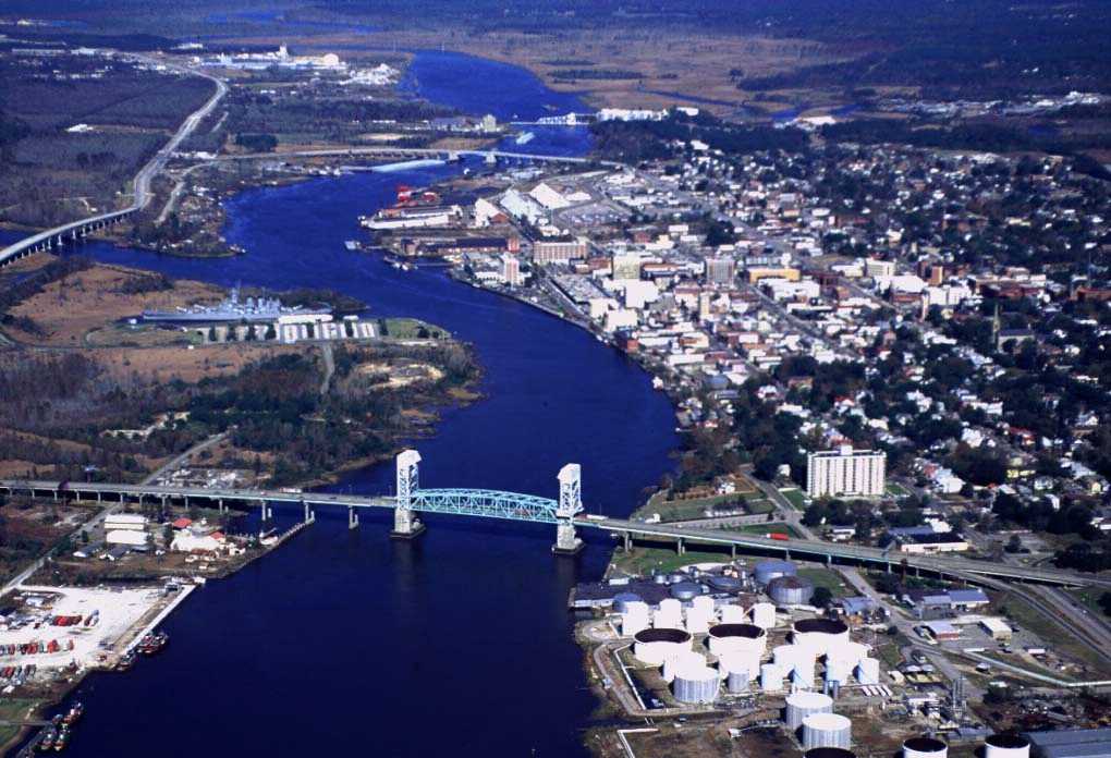
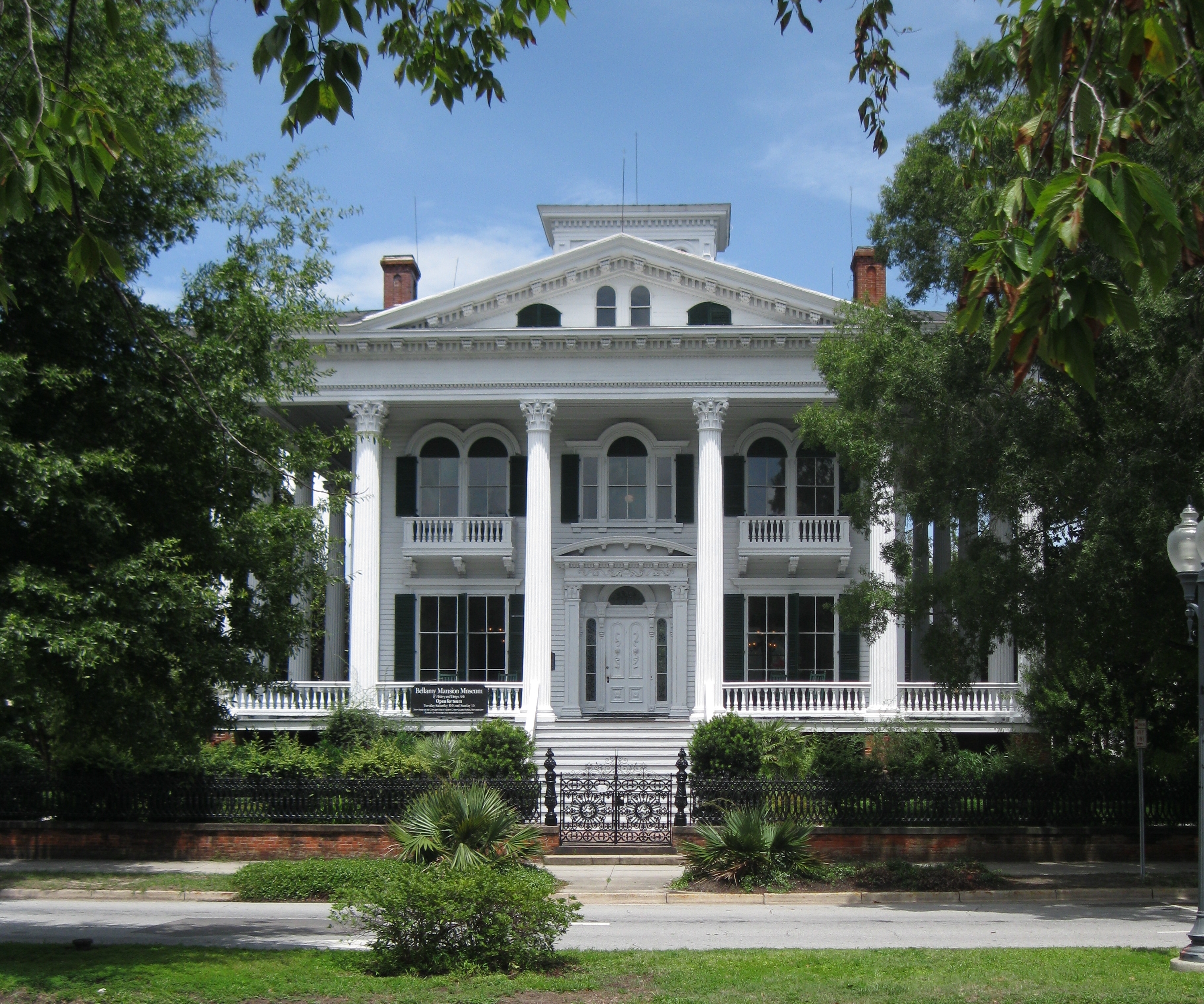
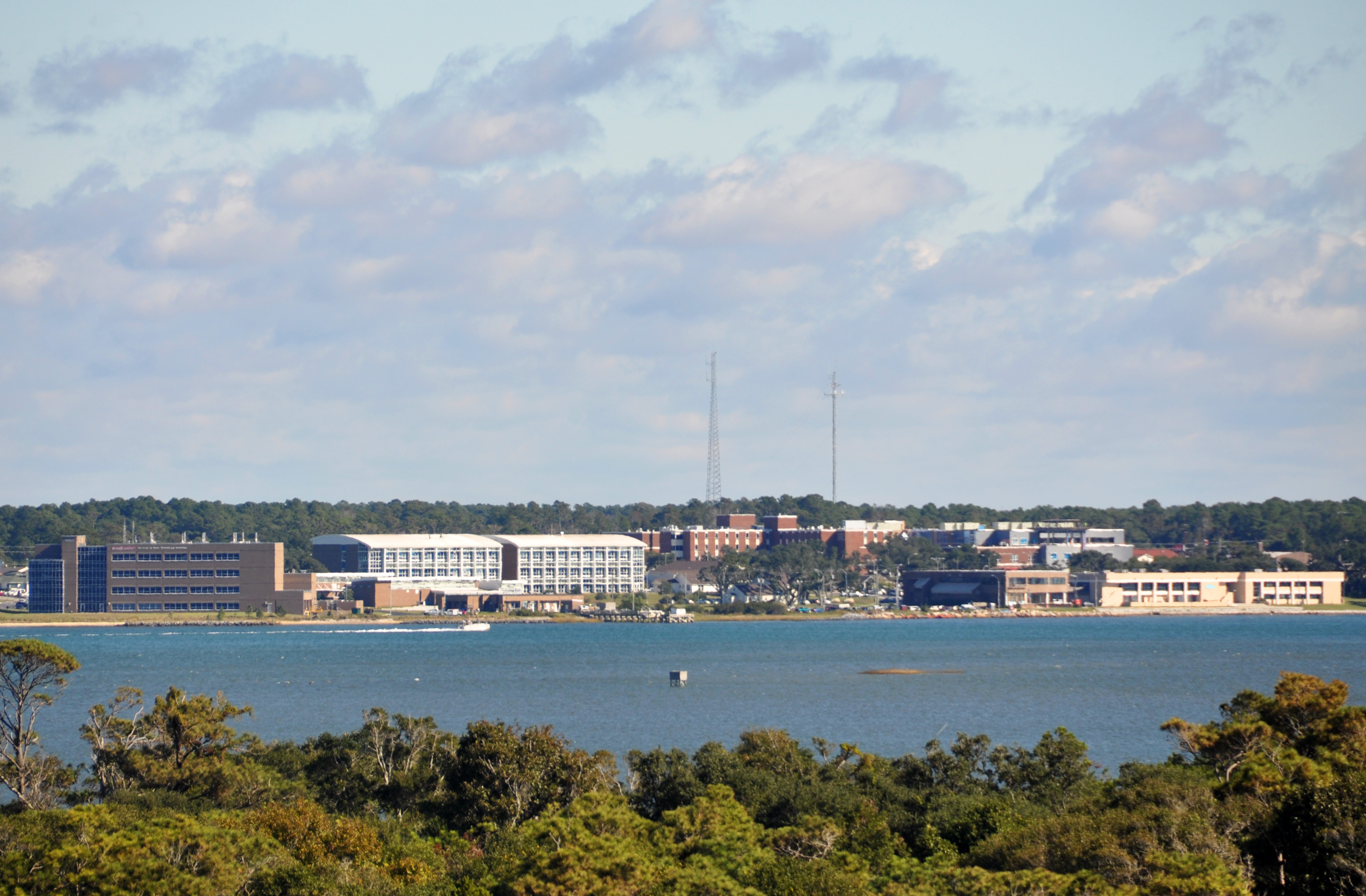
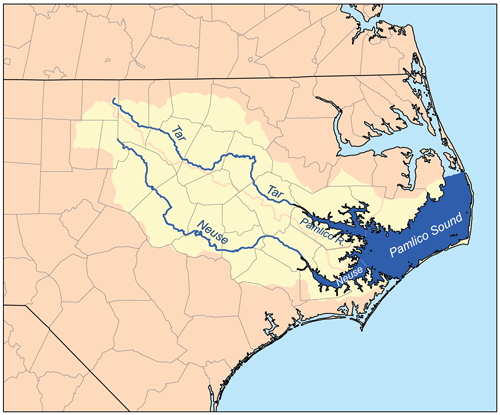
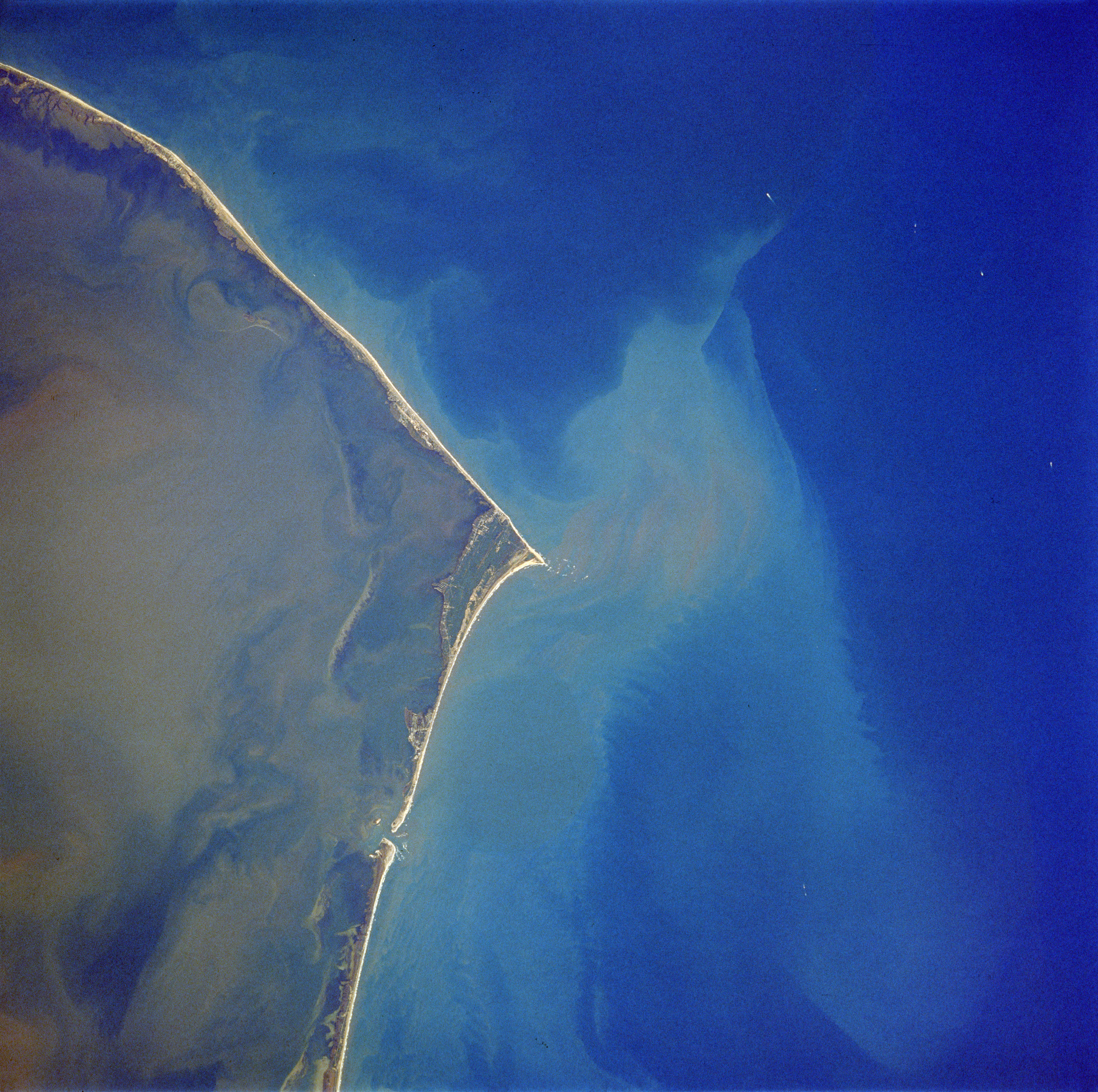
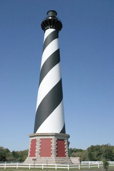
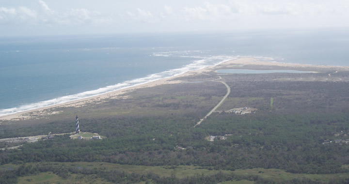
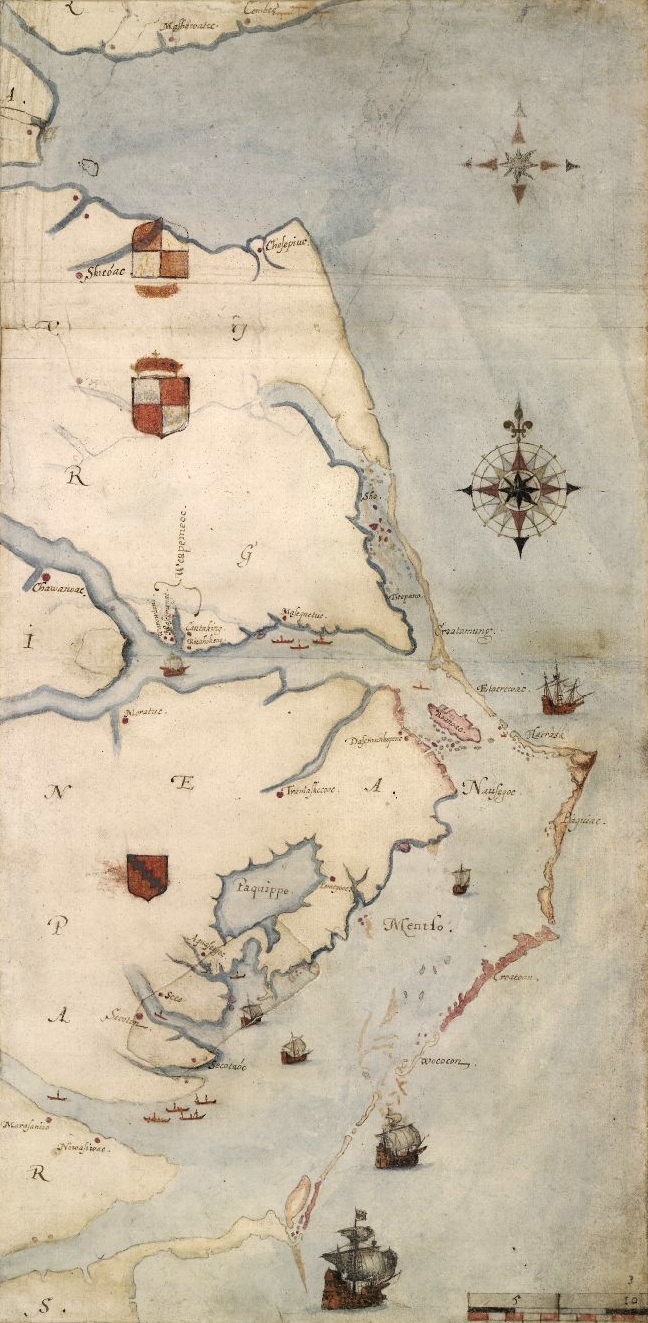
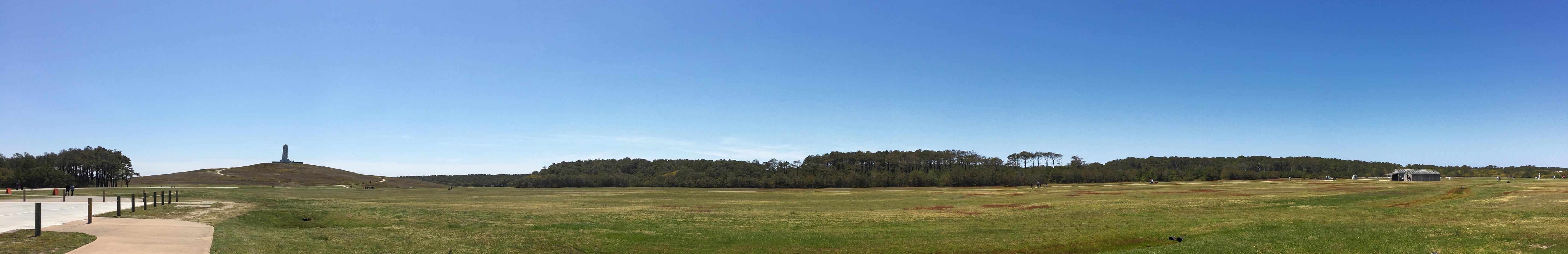
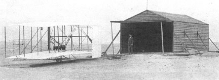
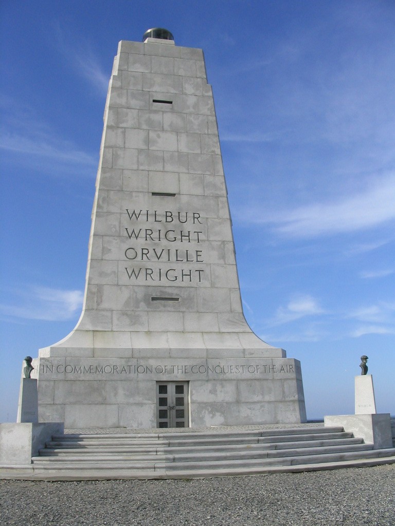
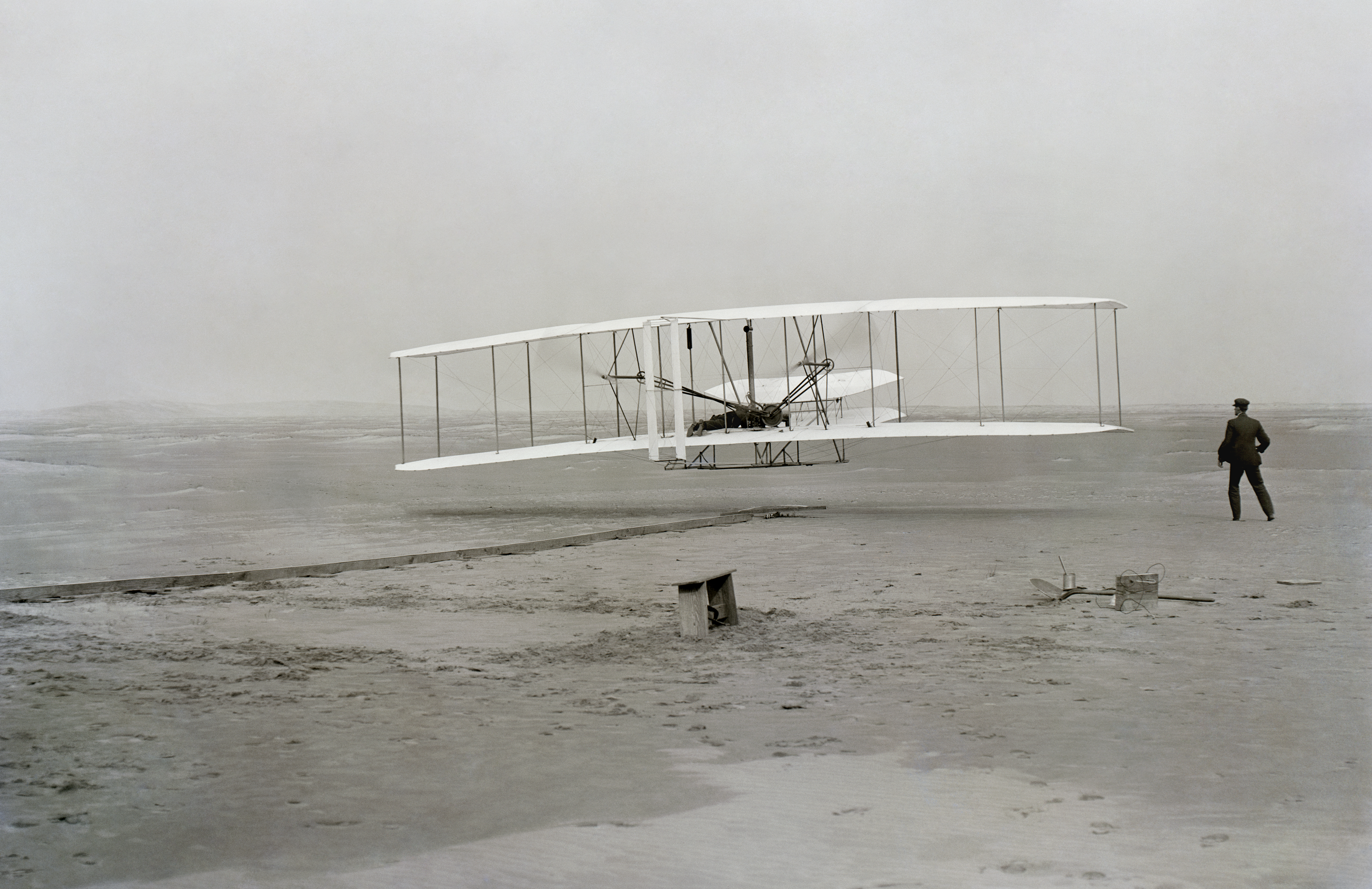