|
Reflections 2016
Series 16
October 10
East Coast VII: Charleston 1 – The Dance - Fort Moultrie - Fort Sumter
| | Charleston: Lay of the Land Charleston's relationship to water is no different than anywhere else on the East Coast—its harbor is a drowned bay. We talked about drowned rivers and bays from Rhode Island's Narragansett Bay to New York Bay, Delaware Bay, Chesapeake Bay (with the broad Potomac estuary), and when we get to NC's Outer Banks on the ship, we'll see more of it there. It's all about an ancient rise in sea level. Charleston harbor (Map by Karl Musser) with its watershed fits the pattern, though it's a bit smaller in area than some others. | | | | You see in pink the city of North Charleston, where the Palmetto let us off. Charleston is in red, and with the central city having a name like Peninsular Charleston, you'll have little trouble finding the downtown area. The watershed is rather compact, with short rivers, but keep in mind two of them, the ones that border Peninsular Charleston, the Ashley on its west side and the Cooper on the east. Looking at this lay of the land, you'll understand the local boast that Charleston is located "where the Cooper and Ashley Rivers come together to form the Atlantic Ocean".
https://www.charlestonsfinest.com/images/ca2009map.jpg
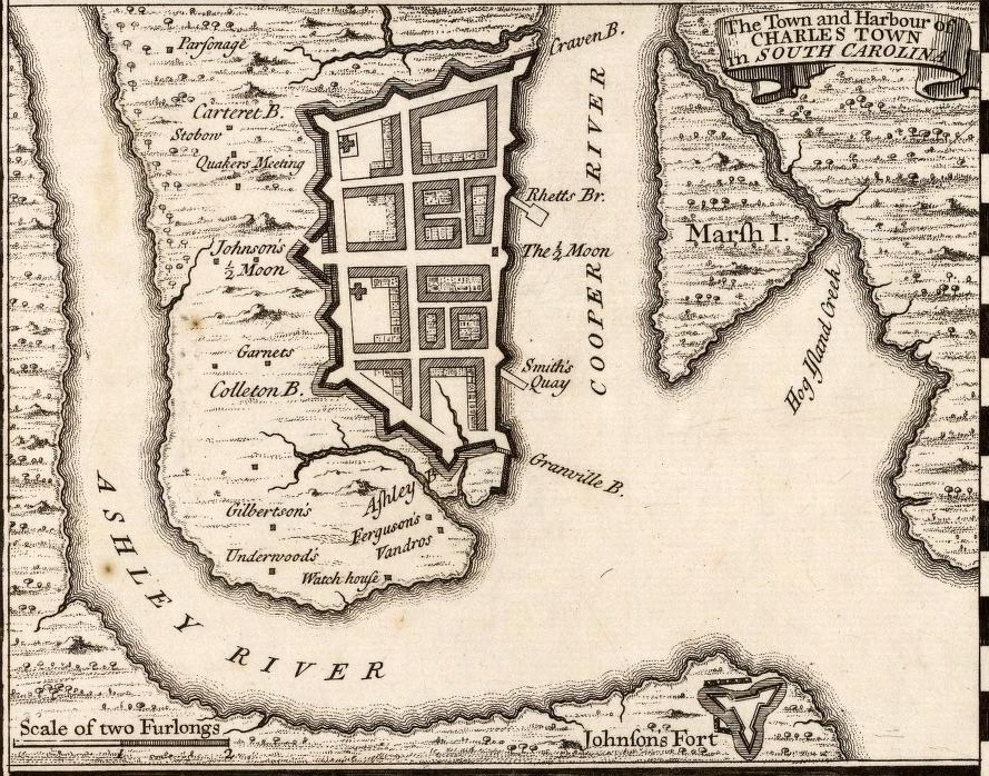
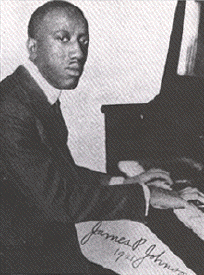
| | | | Hold on to this map of Greater Charleston (click), which is clearer, though it doesn't name the rivers between which North Charleston and Peninsular Charleston lie. Yet it does show that historic flooding goes beyond the harbor, and the whole coastline reflects it. This area is known as the South Carolina Lowcountry (Map by Spyder_Monkey). Although originally the name described the whole coastal area below the fall line, it's now more limited, and on this map, the darker the red, the more frequently those counties are included, with Charleston harbor just below center. It's not only a geographic, but also a cultural region, and it includes the Sea Islands (Map by Kmusser). There are over 100 tidal islands here, which are most easily explained as follows. | | | | On the Greater Charleston map, the entire area here and up and down the coast is laced with the many waterways you see. If, when you picture and island, you visualize something isolated off in the ocean, or at best, an offshore island, look how different the jigsaw puzzle here is. We have James Island, Johns Island, Daniel Island, and others, hardly isolated, but fitting together, jigsaw-puzzle-like, as broken pieces of the coast line. Note in particular for future reference Sullivan's Island, which we'll be visiting when we go to Fort Moultrie, and also the Isle of Palms. You drive over what appears to be a little creek, yet you're entering an "island" that doesn't seem like one. Further south on the SC coast are more jigsaw-puzzle islands attached to the coastline, such as the well-known Hilton Head Island (Map by 636Buster). Note directly due north of Hilton Head that inland white peninsula. Look carefully--it's actually one of these "islands", and another rather well-known one, Parris Island, known for its US Marine Corps boot camp. All these Lowcountry "islands" are just the result of long-term coastal flooding. | | | | You'll recall from the previous posting that it was Charles II who issued the second charter for the Province of Carolina in 1663 to the eight Lords Proprietor, but it took seven years before they arranged for settlement. In 1670, English colonists finally landed on the west bank of the Ashley and named the settlement Charles Towne, after Charles II. It was the capital of the Carolina colony and the center for inland expansion. It remained the southernmost point of English settlement in North America until the Georgia colony was established in 1732. | | | | Of the eight Lords Proprietor, the one who showed the most active interest in Carolina was Anthony Ashley Cooper, 1st Earl of Shaftesbury. This is reflected in the fact that his middle and last names became the names of the Ashley and Cooper Rivers. Shaftesbury, assisted by his secretary and personal physician, who was none other than the philosopher John Locke, drafted the earliest legal documents to govern the colony. | | | | It isn't unusual for settlers to reject their first choice of a location for a nearby place they think better. The first one that comes to mind is in Australia, where, in 1788, the First Fleet arrived in Botany Bay (2010/11), just south of Sydney, but after a little over a week, left, and swung around to north of Sydney to what is now Sydney Harbour for there permanent settlement. We'll see something similar when we later get to Cape Henry VA, the site of the First Landing in 1607. In that case, it was 2½ weeks of scouting around until they found the site of Jamestown, the first permanent settlement. | | | | But in Charles Towne, it took a full ten years before the settlers got fed up with the swampy section of the Lowcountry they had settled in, plagued by disease and mosquitoes, and abandoned it. The ruins are now Charles Towne Landing State Historic Site—find it on the area map. In 1680, they relocated east, from the west bank of the Ashley to the west bank of the Cooper River instead, up a distance from the southernmost point of the peninsula. There they thrived. By 1690 it was the 5th-largest city in North America, and remained among the 10 largest cities in the US through the 1840 census, but under the altered name of Charleston, which had been adopted in 1783, when it was incorporated. | | | | The move to the east side of the peninsula had to have had spectacular results, because of the way the city was built. There were very few fortress cities in North America—I can think of only Spanish St Augustine and French Québec (2013/5)—and Charles Towne/Charleston was to be the only English walled city. As streets were being laid out, a formal fortification plan was developed by 1697 and overlaid on the developing street grid. The layout is clear on this 1733 map. Three of the eight Lords Proprietor have bastions named after them, beyond Aſhley Bastion: Craven Bastion after William Craven, 1st Earl of Craven; Carteret Bastion after Sir George Carteret; Colleton Bastion after Sir John Colleton. | | | | On this map, also note Johnſon's Fort, which will come up on later maps. So the above is the lay of the land, and how it was settled. When we visit the area that used to be within the City Wall we'll discuss it more. There's also additional important SC history to discuss later. Now let's shift for a bit into some potpourri. | | | | The Dance: The Charleston How can you discuss Charleston SC without mentioning the dance--and song--named for it, which carried the name of the city around the world in the 1920s? It was the theme song of those Roaring Twenties. However, neither the dance nor song originated here, but in New York, although it's claimed that it was the music of South Carolina dockworkers that inspired the composer and pianist James P Johnson, who was born in NJ and lived in Manhattan. | | | | | | Johnson was one of the most important pianists who bridged the ragtime and jazz eras and was a model for many famous names that succeeded him. He grew up listening to the ragtime of Scott Joplin (2015/19), and always retained links to the ragtime era, playing and recording Joplin's "Maple Leaf Rag". He may be thought of as the last major pianist of the classic ragtime era, and also the first major jazz pianist, thus bridging the two eras. Aside from the song "Charleston" (one word), he's best known for "If I Could be With You One Hour Tonight", and other hit tunes, many for the musical theater, and was the king of New York jazz pianists through the 1930s. In 1995, the US Post Office issued a James P Johnson 32-cent commemorative stamp.
https://jazzlives.files.wordpress.com/2016/01/james-p-postage-stamp.jpg?w=500
There is a surprising parallel involving Joplin and Johnson. As we reported in that earlier posting, Joplin died young in 1917, at age 49, and was buried in an unmarked grave in East Elmhurst, Queens NY, which I now discover is St Michael's Cemetery. Only in 1974 was the grave marked in a proper tribute. Johnson also died young in 1955, at age 61, and was buried in an unmarked grave at Mt Olivet Cemetery, Maspeth, Queens NY, which is a mere 15-minute drive south of St Michael's. Only in 2009 did the James P Johnson Foundation and others raise funds to re-consecrate the grave with a headstone.
|
| | | | "Charleston" debuted in Johnson's American black Broadway musical comedy "Runnin' Wild" on 19 October 1923, which ran until 28 June 1924. It became one of the most popular hits of the decade and came to characterize the times, although the peak year for the Charleston as a mainstream dance was mid-1926 to 1927.
http://www.house-design-coffee.com/images/life-magazine-art-deco-charleston.jpg
| | | | It was featured on the cover of Life Magazine on 18 February 1928. It's been pointed out that the Charleston, the flapper, and Art Deco hit at the same time, and I'm taken by the fact that a popular dance has been compared to an art movement such as Art Deco, as shown by this illustration. Right at the time of "Runnin' Wild", a Charleston was added to dance sequences in the Ziegfeld Follies in 1923-4, and was performed by Joséphine Baker in the Folies Bergère in Paris in 1926. | | | | I always understood the Charleston to be a dance, and had little idea it had been a song, with regular lyrics by songwriter Cecil Mack. I tried quite unsuccessfully to find a YouTube video that I considered satisfactory of people in the 1920s dancing the Charleston. But we listened to Scott Joplin himself playing a selection on the player piano, so let's start with this 2:40 video of a period player piano playing the Charleston, especially since the signature on the 1924 piano roll confirms that the player who made the piano roll is the song's composer, James P Johnson! Follow the words, at least up to the unusual word "lapazoo", unique to this song. It's most likely a variation of "lollapalooza", meaning "something remarkable", which the Online Etymology Dictionary points out is American English from 1901, and is a fanciful formation. | | | | As for the dance itself, take a look at this 2:46 YouTube video called The Charleston is Sailing to Britain. I'm presenting it (1) so we can hear an orchestral version, although the energetic young woman is doing something that I wouldn't consider more than a rudimentary Charleston, if that; (2) to show the international interest in this American dance; (3) because it's both travel- and transatlantic-related, since it was filmed on Cunard's Aquitania (check out the life preserver at the beginning) sailing to Britain in 1923; (4) to indicate the progress since the silent film era. This film is probably a newsreel, very likely by Pathé, meant to be shown in a cinema, but that's pure speculation. Made in the silent film era, when originally shown, it would have just indicated an energetic woman and busy orchestra, with no sound (try it—turn off the sound). At best, there may have been a pianist playing the music in the cinema, so visualize watching this video combined with the previous player piano version—you're seeing an orchestra and hearing a piano. Therefore, the sound we hear is not coming from that orchestra, but from some other orchestra having recorded the music years later, with film and sound having been frankensteined together. Thus this video does have something to offer besides the rudimentary dancing. | | | | | | The RMS Aquitania was the third of Cunard's "grand trio" of express ocean liners, following the RMS Mauretania and the ill-fated RMS Lusitania. The Aquitania was the last surviving four-funneled ocean liner. On my refrigerator door are two small-sized, laminated copies of posters of the Aquitania that I bought on the QE2. |
| | | | The dance has been used in films too numerous to mention. Probably most people will remember the high school Charleston contest in Frank Capra's 1946 It's a Wonderful Life; this YouTube video (3:33) shows James Stewart and Donna Reed doing their best. Another is from the 1942 film called "Roxie Hart", an adaption of the 1926 play "Chicago", on which the later musical was also based. Here's a short YouTube clip (0:46) of a more professional dancer doing the Charleston, Ginger Rogers, although apparently this particular scene was deleted from the film. | | | | The Single House In our potpourri we move within the arts from dance to architecture. In Charleston, the 18C and 19C architecture alone merits a visit, and among the architecture to pay attention to is the style, which seems to be purely from Charleston, known as the single house. Let me, for fun, first deconstruct the clever concept, and then we'll look at it more carefully and seriously. The house proper has no street entrance. The "front door" is on the side of the house. The side with the entrance has usually two porches, sometimes three, one above the other. The porches have a special name, piazzas, and if you use your common sense, you're sure to end up mispronouncing the word (see below). Actually, there is a street door, but it doesn't lead into the enclosed part of the building, it leads to the end of the ground-floor piazza, and while it's not a faux door, and IS an entry to the property, it doesn't get you into the house. Put it this way. If it's cold out on the street before you enter through this door, it'll be just as cold on the other side of it, no different than as if you were going through a garden gate. | | | | Let's put that confusing deconstruction together for these clever structures and look at a prime example of a Charleston single house (Photo by ProfReader). The Charles Graves House at 123 Tradd Street in the South of Broad neighborhood is a classic example of a single house, with its narrow end, three windows wide, facing the street, doorless; a faux street entrance to the side, passing through which you're still outdoors—in reality, it's merely a screen protecting the private piazza; a piazza on two levels; and a true front door hidden in the lower piazza halfway along the longer side of the house. It's called a single house because it's just one room wide—usually with 2-3 windows, below a gable--and two rooms deep—usually with 4-5 windows--so when you enter down the side, the entry hall is between the front and back rooms.
http://blog.carriageprop.com/wp-content/uploads/2015/12/Screen-Shot-2015-02-25-at-5.10.43-PM-640x517.png
https://houseplansllcblog.files.wordpress.com/2014/10/eric-moser-screen-shot-2014-10-08-at-10-55-53-am-2.png
| | | | Above is a sketch of a generic single house, followed by a generic floor plan of another. On the lower piazza you see the entry in the center leading to a central hall with the staircase. I don't see a door to the upper piazza, so apparently in this case, all five windows up and down are actually French doors. | | | | Walking or driving around Charleston you see dozens and dozens of these in all the traditional historic neighborhoods, in Federal, Greek Revival, or Victorian style. Some are more elegant, some more modest, such as the single house at 10 Ashmead Place (Photo by ProfReader) up in the Mazyck-Wraggborough neighborhood. It's only two windows wide, but if you look it over, it has all the typical features. Single houses developed probably because of the long narrow lots available, plus perhaps a desire for easy piazza access in the hot SC weather. It's apparently based on a West Indies design, since many early settlers were planters from Barbados. | | | | Quirky Charleston Pronunciations Now about that pronunciation of "piazza". We all know what to do when we come across an Italian ZZ in the middle of a word, such as pizza, mezzo-soprano, paparazzi, and we even noted the recent word for magpie, gazza. Most of us, when confronted with Piazza San Marco (St Mark's Square) in Venice, would know that this bit of doggerel à la Ogden Nash would rhyme: | | | | | | The piazza
Has lots o'
Cafés.
|
| | | | Not so in Charleston. Here, when someone refers to one of those porches on a single house—go figure--this would rhyme: | | | | | | | | Another pronunciation: to protect a harbor, colonials set up a battery of cannon. The one at the southern tip of Manhattan near me is Battery Park, and everyone knows how to sing "The Bronx is up, but the Battery's down". Charleston also has a landmark park at the southern end of the peninsula called the Battery. But here, drop a syllable down to two, and call it the Batt'ry. However, that isn't unique to Charleston, as that pronunciation appears elsewhere across North America. | | | | There are unusual pronunciations everywhere, and we recently spoke (2015/9) of some place names in New Orleans with unexpected pronunciations. Charleston has its share. Here, Barre Street is pronounced like Barry, but in fairness, the granite-mining city of Barre VT is pronounced the same way. But Legare Street sounds like Legree; Hasell Street sounds like Hazel; Vanderhorst Street comes out as Vandross. To me, the oddest one is Huger Street. Pronounce it by saying the letters U and G in succession, stressing the G. Or, look at it this way: while YU.ji would rhyme with Mount Fuji, this is actually yu.JI. Fort Sumter also has a Battery Huger, so have fun with those two words: BA.chri yu.GI. Welcome to Charleston. | | | | Fort Moultrie Our next topic belongs within the narrative, but is being pulled up front because of chronological sequencing, which last had to be done in Gettysburg. There, we visited the David Wills House on the first day, but just mentioned it in passing, since discussing it came logically after we visited the battlefield on the second day. We have the reverse situation in Charleston. Fort Moultrie had to be left to the second day when we had a rental car, but its story comes first, certainly before Fort Sumter was visited on the first day of the visit. So this is the background, and narrative, brought up early where it chronologically belongs. The sequential narrative of the two days will then follow. | | | | In the late spring of 1776, recognizing that relations were coming to a head between American colonists and Britain, South Carolina decided that Charleston and its harbor needed additional protection beyond Fort Johnson from invasion by sea, and so it was decided to build what was at first called Fort Sullivan on Sullivan's Island on the east side of the harbor entrance. It was later renamed Fort Moultrie with good reason, and that good reason is what this story is all about. Find it facing the harbor entrance on the map of Greater Charleston. | | | | Now this story has a condensed version: the fort was made of very soft wood, and was able to hold out against British naval cannon fire after a day's fighting, since cannonballs bounced off the wood. The British, uncharacteristically, yielded, Charleston was saved, and the British went off to concentrate on the northern colonies, not returning until four years later, when they did occupy Charleston in 1780. This is the way I first came across this story--a nice story, but it's less than compelling. You have to look into it more deeply, and visiting the site is a real help. So that's what we're going to do. | | | | With the rental car on the second day, we drive off the peninsula over the bridge (see map) and with no trouble, find we're on peaceful Sullivan's Island and arrive at Fort Moultrie. We review the displays at the Visitor's Center, and find a separate exhibit about the local area. it turns out that Sullivan's Island was the point of entry for approximately 40% of the 400,000 enslaved Africans brought to British North America. In its own way, it's been compared to New York's Ellis Island as a 19C reception point for immigrants. | | | | The present Fort Moultrie was built out of brick 33 years after the battle, in 1809, and was an active military installation in all conflicts after that until WWII, although it had been replaced in importance in the mid-19C by Fort Sumter, an upcoming stop of ours. After WWII it was decided that coastal military installations had become obsolete, since they only protected from naval attack and not air or missile attack, and so the fort was decommissioned in 1947. It was turned over to the National Park Service in 1960, and is now part of Fort Sumter National Monument. It is, however, the only area of the NPS where the entire 171-year history of American seacoast defense, from 1776 to 1947, can be traced.
http://www.starforts.com/gr/moultrie/moultrie.jpg
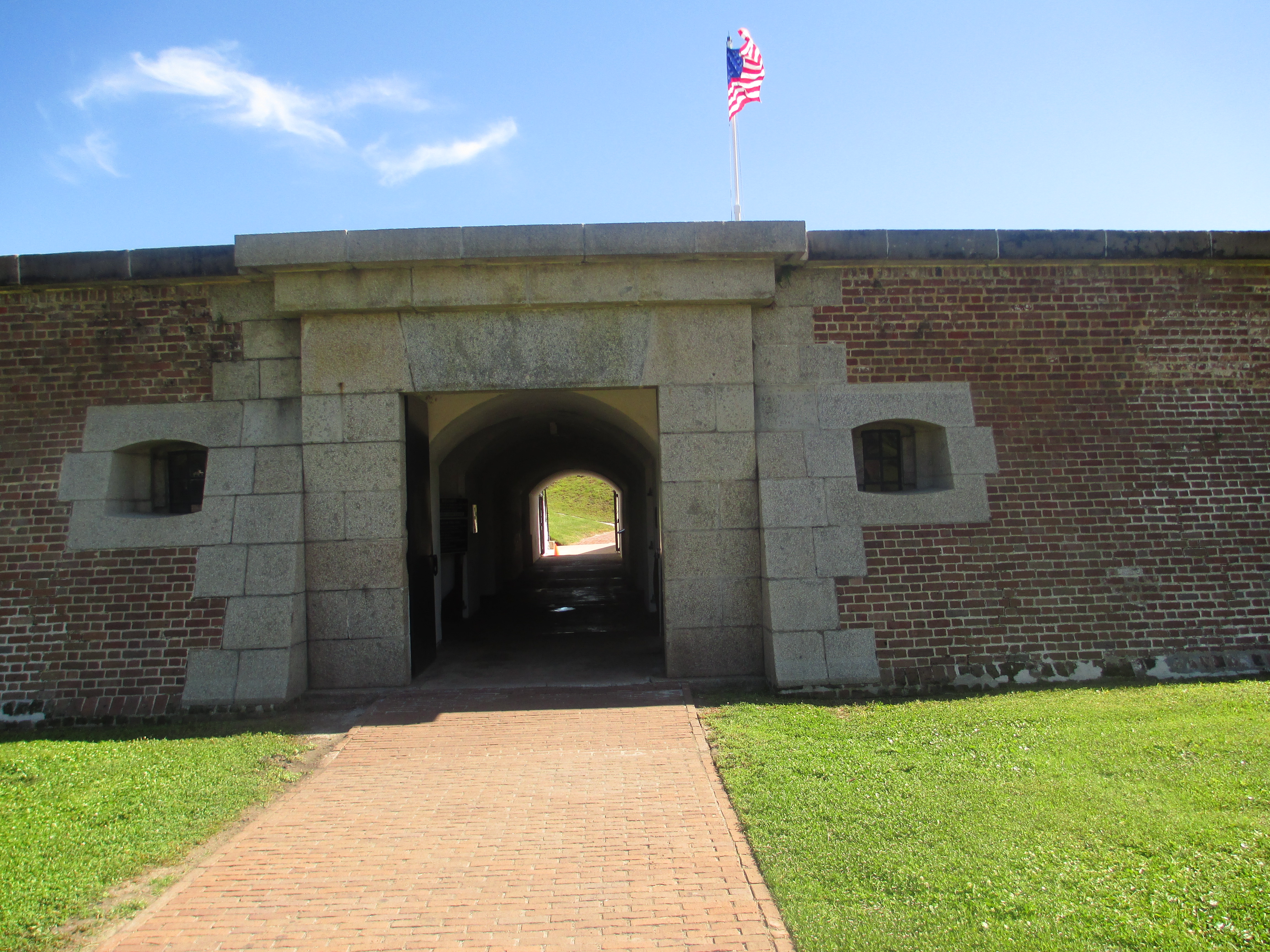
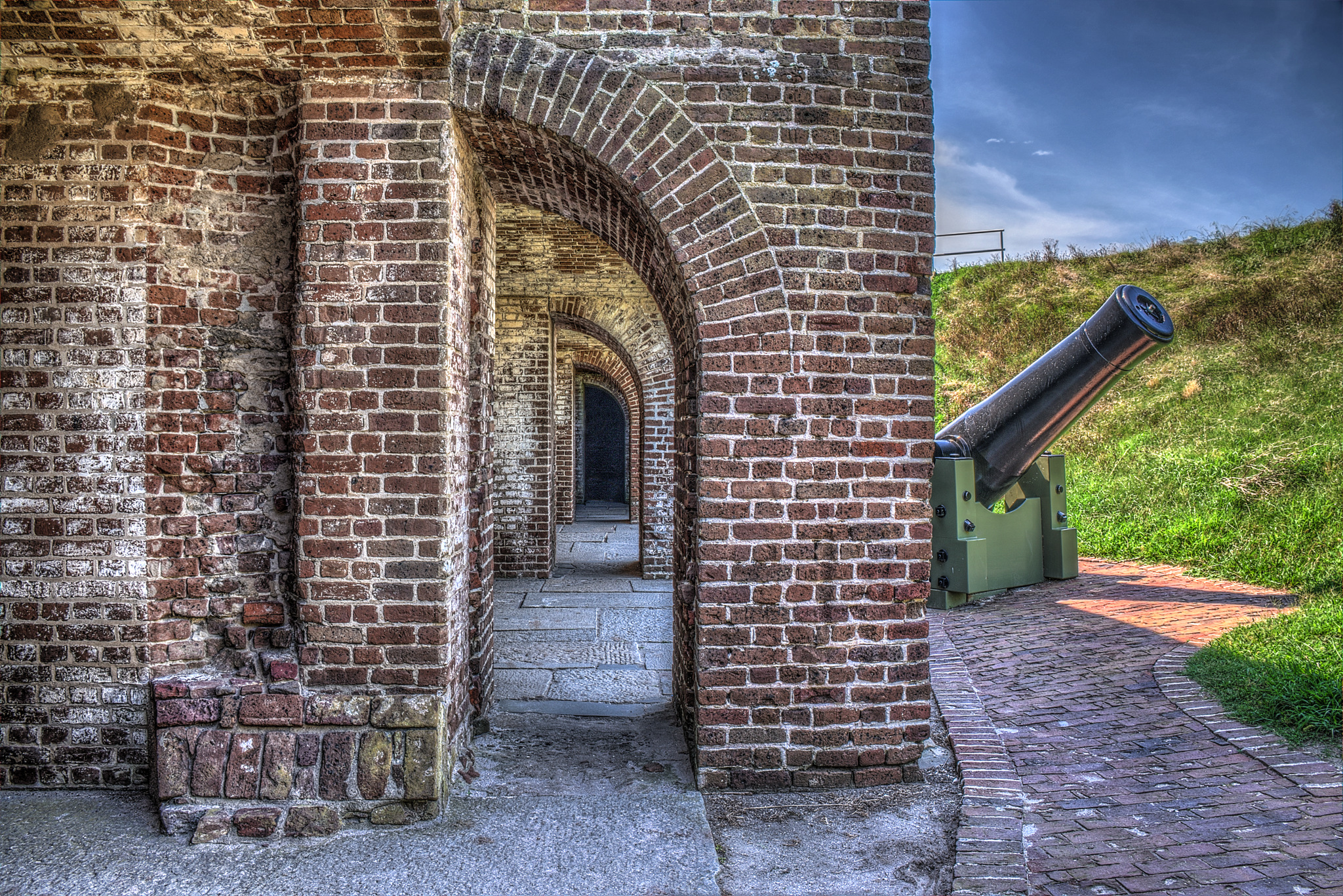
| | | | This aerial view is oriented with the Visitors Center behind us, to the north, so that we're facing Charleston harbor ahead of us, roughly to the south. As we walk across the road from the Visitor Center, the entry to the fort (Photo by Billy Hathorn) seems perhaps rather small, although the whole fort itself isn't all that large, either. But it's a sally port, a protected entrance, through which troops could attack an enemy. Yet it's an interesting thought to picture what use it would have been as late as WWII. Once through the entry, though, the entry corridor (Photo by Brian Stansberry) shows the massiveness of the otherwise smallish structure. Before entering the central area, one could wander through the underground rooms.
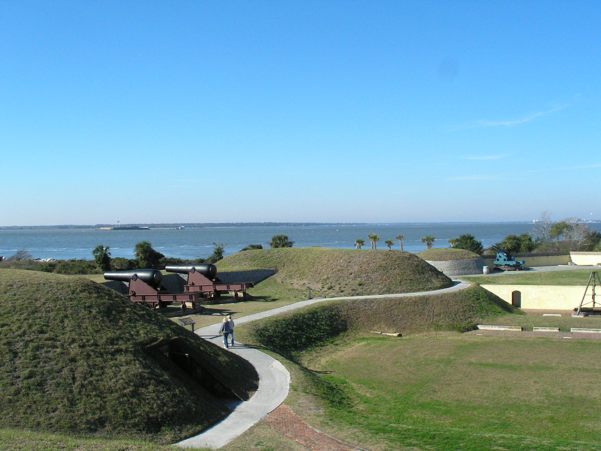
| | | | Once out in the center court, we notice how cleverly the self-guided walking tour is set up. Pinteresquely, it's in reverse chronological order, from WWII back to the Revolution. Check the aerial view again. One starts in the 8-to-12 o'clock position including that black-tarred-roof area, which is set up as a WWII Command Post. I assume the whole fort looked like this at the time. From the 12-to-2 o'clock position is the area demonstrating the 1870s post-Civil modernization, with appropriate cannon, moving us back past the early 20C into the late 19C. The area between 2 and 3 o'clock shows how the fort was during the Civil War, under the Confederates. The area between 3 and 4 o'clock is called Fort Moultrie III, and is meant to show what this structure looked like from its construction in 1809 to about 1860, as the Civil War started. | | | | Before we continue, let's look at some views here. Over to the left, we get this view over the harbor from the WWII area to the adjacent area (no attribution). If you click, you'll get a surprise. You'll find the ruins of Fort Sumter and the ferry we'll be taking later, located at the end of the long pier. This is how close the two are. Notice the multiple flags. Moving slightly to the right, we get this view (Photo by DDima) showing cannon of different eras. Clicking now will not only show Fort Sumter and the Ferry, but also Charleston way to the right. This is a newer picture, and you'll see only one flag at Fort Sumter, the US flag. More later.
| | | | On our aerial view, furthest to the right, in the oldest area, you'll see a black roof on a yellow building. That was the powder magazine (Photo by Brian Stansberry) of that era, and this interior view shows how gunpowder was stored in the 19C (Photo by Brian Stansberry). We saw similar powder magazines at Fort Anne in Annapolis Royal, Nova Scotia (2014/20) and on the Mississippi in Fort de Chartres, Illinois (2015/8). The barrels are, of course, reproductions, but if you're as much of a snoop as I am, you'll click to see some familiar names. Those on the left say 1834 and Baltimore MD, and those on the right say 1837 and Wilmington DE, two destinations on this trip. Better still, the Delaware ones also say E I Dupont [de Nemours & Co], which is not only famously from the Wilmington area, but which was founded in 1802 specifically to manufacture gunpowder. Snoops learn things.
https://marksphoto.smugmug.com/CivilWarBattlefields/Fort-Moultrie/i-NcGT6Q2/1/XL/FortMoultrie_04-XL.jpg
| | | | This aerial view is similar to the previous one, which I used because it was oriented correctly, but I like this one much better, even though we're looking east here with the harbor to the right. You can see the Visitor Center on the left and the yellow powder magazine. We still haven't found the oldest of the old, and to do that, we follow the signs and go out toward the beach on that loop walk. Starting at the powder magazine, we exit the walls and follow that white path. We'll then come back later on the far side to reach the Visitor Center. | | | | The best view of where we're going is shown in this picture taken from that black-roofed area (Photo by Ser Amantio di Nicolao), and it's somehow appropriate that we're looking from the newest iteration of the fort to the oldest. Where we're looking at is to the right of those two cannon to where the people are standing, checking out an exhibit. If you feel you don't see anything, that's because there's not exactly anything to see. | | | | As we walk down that path from Fort Moultrie III, we find that there no longer is a FM II or FM I, and worse, their exact locations somewhere here on the beach (now covered by a lawn) are unknown. How could simple wooden structures last in this semi-tropical climate, subject to storms and hurricanes? But the exhibit here on the lawn has a great deal of information, and carries one right into the spirit of the battle. | | | | Moving backward in time, FM II was not wooden, but it was still simple, an enclosed, five-sided earthwork with some brick. It had a short life: it was built in 1798 and a hurricane took it away in 1804. But it's Fort Moultrie I that was the inspirational one, although when it was built, it was still called Fort Sullivan. Here's the story that we came here for. Being at a historic location, even when there's nothing to see, is compelling, since an appreciation of history dwells in the mind, and its ability to conjure up images. | | | | Revolution was brewing in 1776 when Charleston decided it needed a fort here to protect the harbor from British invasion. And it had to be built quickly, precluding a stone fort, or even an earthwork one. Wood was available, and the choice of wood in an emergency was unusual. Not hardwoods, not even softwoods like pine—they had to use palm trees to build their fort. | | | | In the US, the palmetto, also known as the sabal palm, is one of 15 species of palmetto palm, and is native on the coastal plain from southern NC to Florida to Texas. The word "palmetto" is very interesting, as it didn't start out as an English word. The Spanish word for "palm [tree]" is palma, and Palma, for instance, is the name of the capital of Mallorca. It forms a diminutive in palmito "little palm", even "dwarf palm", which is odd because the word changes gender from feminine A to masculine O. (I suppose gender reassignment is "in" right now, anyway.) | | | | | | Latin palma meant first "palm [of the hand]", then was extended to "palm [tree]", because the leaves were seen as being shaped like fingers on a hand. Spanish, as a Latinate language, still has that form. Though the tree is tropical, Christianity spread the word to northern Europe, so that the Old English form was also palma. Old French altered it, in both senses, to palme which was brought across the Channel to English as "palm" in both senses. However, in Modern French the OF form became paume when referring to a hand, but palmier (pal.MYÉ) for the tree. This is not unusual, since Spanish also uses palmera Portuguese palmeira, as do others. Actually, the word "palm" is very international, either appearing with no ending, , with -A, -E, or something similar to the –IER.
As a lagniappe, I'll add this, particularly in reference to that last construction. In the 12C, religious pilgrims who returned from the Middle East wore palm branches to commemorate the journey. French palmier also crossed the Channel as the hybrid Anglo-French form "palmer", which then became the surname Palmer. The late golfer Arnold Palmer comes to mind.
|
| | | | Then the strangest thing happened to the Spanish word palmito. It became Italianized, of all things, to "palmetto", for which I have no explanation. The same diminutive ending appears as -ito in Spanish, -etto in Italian, and -ette in French. English adopted the French forms for words such as "kitchenette, dinette, cigarette". If we were to make up an English form for the tree's name it would be *palmette, to describe a little palm, but that word doesn't exist (as the asterisk shows); we have the Italian form instead. | | | | This is a palmetto, or sabal palm (Photo by Bubba 73). They're not all this stubby, since these taller ones (Photo by Mmcknight4) are also palmettos. At this point we can add that, although, in everyday use they are called trees, they aren't really trees at all, not in the sense of a plant that grows a woody trunk. The stems are made of fibers instead, and palms are more closely related to grasses rather than trees. This is a sawn palm trunk (Photo by Kadeve), and it's obvious that palms do not form annual tree rings as true trees do. Click to inspect the fibers, especially noticeable along the top edge.
| | | | So we come back to the question: how do you build a fort—Fort Sullivan, later called Fort Moultrie I—out of palmetto logs like this? I can now supplement the earlier short version of the story. True, the palmetto logs were so soft and spongy that British cannonballs had little effect, since the logs absorbed much of the impact. But I didn't know the much fuller story until I came down to the display at the (approximate) actual spot on the loop walk where it happened. | | | | The palmetto walls of the fort were only 10 ft (2.7 m) high, but Moultrie and his men didn't just build one. In addition to the outer wall, they built an inner palmetto wall. The walls were 16 ft (4.9 m) apart. And—it gets even better—the space in between was filled with sand. Picture it this way: they built a sand castle on the beach, but one that was supported on both sides by walls—palmetto walls, but walls nevertheless. This is the same procedure used by thermopane windows today, where double glazing, or two panes of glass, are separated by dead air as insulation. But that concept doesn't involve impact. A closer parallel is seen on highways today where a lane is close to an overpass, where a plastic container filled with sand or water, called technically an impact attenuator, but more commonly a crash cushion, protects the overpass by absorbing the impact of a car out of control, that is, its kinetic energy. At Moultrie, then, it was two layers of spongy palmetto logs backed up by soft sand that absorbed the kinetic energy of British cannonballs and saved the day. | | | | This is a map of the fort at the time of the battle, but made at a later date. Click on the right to note the nine British ships, listed by name, that took part in the Battle of Sullivan's Island. Then on the left, inspect the fort. It was 500 ft (152 m) square with a bastion at each corner. It had 31 cannon, while the British had almost 300. But standing on that beach looking at this map in the display I was amazed, and I'm sure you've been as well. At the time of the battle, the entire back wall with its two bastions, as well as the east wall of the fort, were incomplete. This wasn't a fort—it was really no more than a palisade, just a wall with troops standing behind it. If the British had had land forces, they could have just gone behind the structure to attack. | | | | We've talked about the fort, now let's talk about the battle. The British had organized an expedition in early 1776, as hostilities were brewing, against the rebellions southern colonies in North America. Admiral Sir Peter Parker, backed up by General Henry Clinton, decided to act against Charleston. Their nine warships arrived in early June and landed troops on nearby Long Island. I had a hard time finding this island until I found that it's been renamed the Isle of Palms up the coast a bit to the east—see the Greater Charleston map. In other words, the General planned a land assault while the admiral planned a naval bombardment. But the land assault fizzled out when they found that the channel between the two islands was two deep to wade across and then the fort also prevented an amphibious landing à la D-Day. A British Army officer made a sketch of the area, of which this engraving is today located in the Library of Congress. It again shows the nine ships at Sullivan's Island, shaped quite differently than it is today. At its northern end are "Rebel Tents and Huts" with a " 'Fort' With Two Pieces of Cannon". Above is Long Island (Isle of Palms today) with the British Camp. The watery distance between them is marked at one point only "18 Inches Deep" (0.5 m), but further down it says "Deepest Channel 7 Feet" (2.1 m), indeed too deep to wade. Admiral Parker knew the fort was only half complete, and yet he expressed confidence that his ships could easily breach the walls of the fort, and optimistically believed he wouldn't even need General Clinton's land forces. (Ha!) | | | | The battle was fought on 28 June 1776 and lasted 9-10 hours. This painting, an oil on canvas courtesy of the Colonial Williamsburg Foundation, is by famed American artist James Peale and is titled Sir Peter Parker's Attack Against Fort Moultrie. Note how Peale shows the ships to one side in order to display two things, the palmetto logs in the fort's walls and the blue flag with the white crescent. That flag has some stories of its own. | | | | During the battle, the flagstaff was actually shot away. But a certain Sergeant William Jasper famously ran out in the open and dramatically hoisted it again, as shown in this 1858 image in the New York Public Library, until a new flagpost could be provided, a gesture that rallied the troops and became an iconic symbol of the battle. Actually, I now find that William Jasper was a German immigrant originally named Johann Wilhelm Gasper, and he's considered a noted soldier of the American Revolution. Across the US there are at least 8 counties, 7 cities, and 3 towns named Jasper after him.
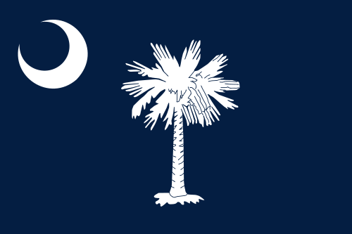
| | | | The battle flag known today as the Moultrie Flag had been designed by Colonel Moultrie himself the previous year, 1775, when he took over Fort Johnson, closer to Charleston. This is what the Moultrie Flag (Image by K Aainsqatsi) is usually considered to look like. If you think that's a funny way to express that, let me point out the US postage stamp where I first learned years ago about Fort Moultrie. A series of historic flags appeared on several stamps, and this is the 1968 six-cent US Moultrie Flag stamp. From when I first learned about Fort Moultrie, it took me 48 years to actually visit it. It's not that it was on my bucket list, but when I knew I was spending time in Charleston, it became a must-see. | | | | But the point is, you'll note a difference—just where the word "LIBERTY" appears and in what size. And it gets more complicated—why is there any writing at all? Before we discuss that, let's add one more complication. Just what is that symbol on the upper left? | | | | The symbol could be one of two things, and the bottom line is, no one knows for sure, and historians are split on the subject. Most obvious is that it's a crescent moon, although what that would mean symbolically on a battle flag is unknown. The other possibility I've found is that it's a gorget (GOR.jit), which is both a word and concept I've now learned. Simply put, it's armor worn at the throat. But here's more. | | | | The word comes from the French gorge "throat" (GORZH). It started out in medieval times as a band of linen worn by women, but then became a metal or leather collar soldiers used to protect the throat area during battles, and eventually became a piece of armor for that area. But from the 18C onwards, the gorget became purely ornamental, particularly for officers.
http://www.nam.ac.uk/online-collection/images/960/96000-96999/96631.jpg
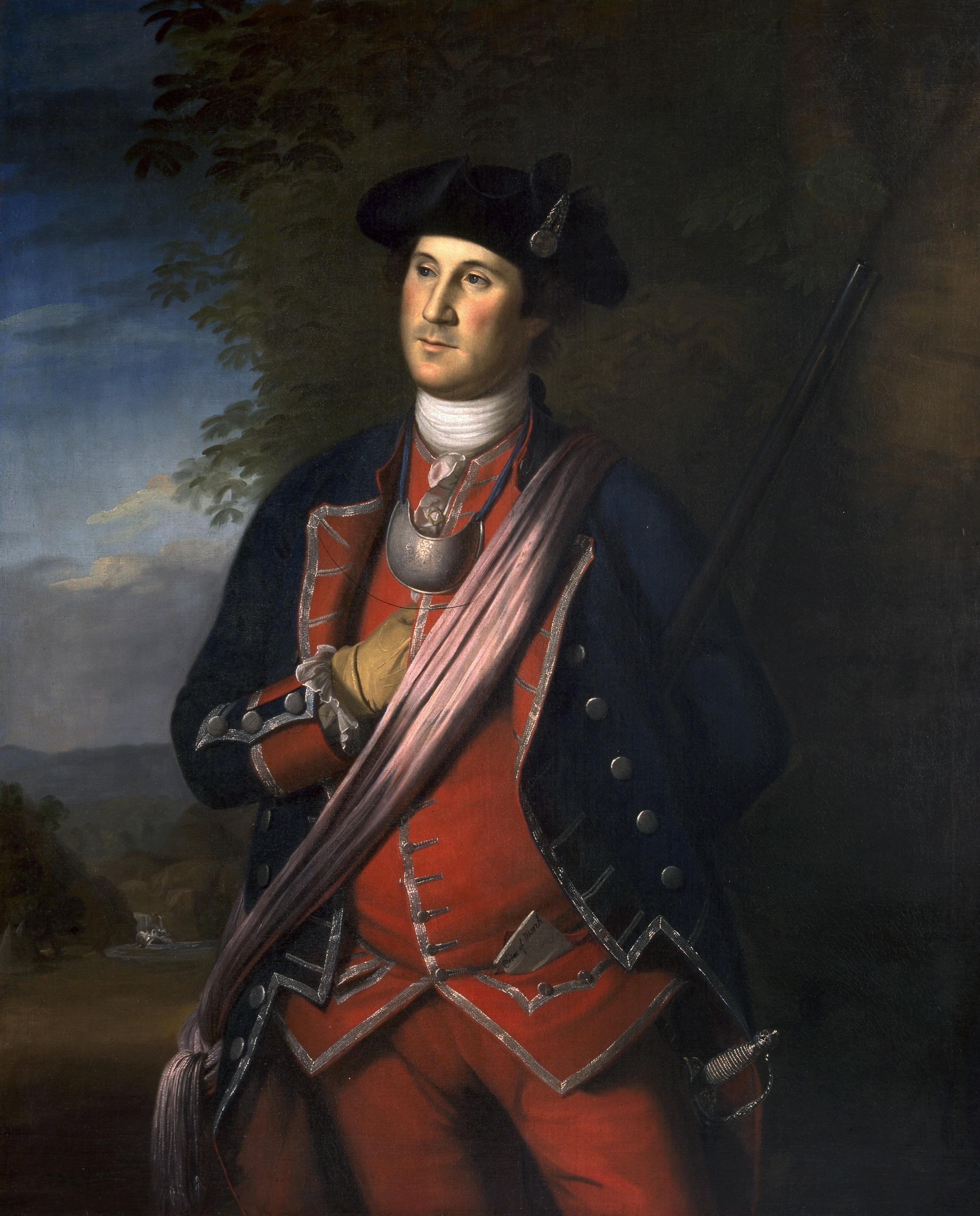
| | | | This is a particularly decorative gorget made of silver with British insignia on it. It also has holes in the tips for hanging around the neck. We just saw a battle picture by James Peale. We now have a portrait by his even more famous older brother, Charles Willson Peale, of George Washington. This oil-on-canvas was painted in 1732 when Washington was 40, and is the earliest authenticated portrait of him. This is during the French and Indian War, and he's wearing his colonel's uniform of the Virginia Regiment. But now click to inspect the purely decorative gorget hanging around his neck to show his rank. Also note the cord it's hanging from. Though no one knows for sure, my vote is that the Moultrie flag is not sporting a crescent, but instead is a battle flag with a military symbol, a gorget. | | | | Now back to the first question about the word. I found a flag website that brought up the issue, and had a report from someone who lives near Fort Moultrie. He went there and spoke with the on-site historian. The historian believes that the true original flag, flown during the battle, and rescued by Jasper, had no writing on it at all. It was a plain blue flag with a crescent—or gorget—in the upper left corner. He said that nowhere in Moultrie's memoirs was there a reference to the word "LIBERTY" being anywhere on the flag. But he noted that it was fashionable at the time for soldiers to engrave that word into their gorgets. That custom might be the reason that the one version of the flag has that word on the gorget—and is a further indicator that it IS a gorget and not a crescent. But this happened only after the battle—not too long after, but after nonetheless. Finally, Charlestonians began enlarging the word and moving it to the bottom of the flag, as on the postage stamp, but that, too, never flew over the fort during the battle. The final answer from the historian was to admit that each of the three versions has its own historical merit, but the true, original flag was without writing. | | | | In any case, both the battle and the dramatic Jasper event made the flag an endearing symbol in South Carolina, in the South, and in the US. Moultrie wrote in his memoirs that "this was the first American flag displayed in the South". It was so popular that the Moultrie Flag became the basis for the South Carolina Flag, another indication that the original flag had no writing. But by far most obvious is the palmetto tree, and a rather stubby version, at that. Because of that battle, not only does the flag and state seal use the palmetto, the nickname for South Carolina is The Palmetto State. And you'll also recall that Amtrak's train from New York to Charleston (and nearby Savannah GA) is called the Palmetto. | | | | We never finished talking about the battle. The 400 defenders of the fort wrought significant damage to the British ships, which withdrew. They didn't attempt to take the fort again, and Charleston was not invaded. I would think timing was a factor. Remember, the battle was on 28 June 1776, and just six days later, the Declaration of Independence was signed in Philadelphia. The British stayed until 21 July, but then the fleet withdrew northward to help the British army in its campaign against New York City. | | | | Colonel William Moultrie was made a General, and Fort Sullivan was then renamed Fort Moultrie. It was four years before the British came back. In 1780, they did besiege Charleston and take it over, but they came by another route, showing due respect for Fort Moultrie. At that point, the British did also take over Fort Moultrie as part of the siege, and they reamed it Fort Arbuthnot. They held Charleston for two years, but when the war ended, the British troops departed in 1782.
https://allthingsliberty.com/2013/09/top-10-battles-revolutionary-war/
| | | | Curious about the status of this Battle of Sullivan Island, I came across this website called the Journal of the American Revolution. It listed the author's opinion of the Top Ten Battles of the Revolutionary War, which we can use it as a guide. He lists them chronologically, starting with (1) Lexington & Concord, April 1775 (2011/21), (2) Bunker Hill, June 1775 (also 2011/21), (3) Québec, December 1775 (2011/16: see "Ticonderoga"). But his number (4) is Charleston, June 1776, and you'll note his comment: Often disregarded as a minor action, the British failure to take this major seaport forced the war’s focus to be primarily in the north for the next several years. This can be confirmed by the remainder of the list, where Carolina isn't mentioned again until (8) Kings Mountain in 1780 (the town's in NC, but the battle was fought over the state line in SC) and (9) Cowpens (in SC, near the previous battle) in 1781. | | | | His list is not definitive, and subject to interpretation—note the comments below his list suggesting other battles that should have been included, most notably the Battle of Brooklyn (Battle of Long Island) on 27 August 1776. It strikes me that Fort Moultrie deflecting the British away from Charleston resulted, among other things, in the British forcing George Washington and his troops to escape in the dark of night down the slopes of Brooklyn Heights to the East River and to temporary safety in New York (Manhattan)—see 2011/16 for details.
http://www.charlestonhomelistings.com/charleston-downtown-map.jpg
| | | | Peninsular Charleston Now we're ready to talk about Peninsular Charleston. This trip I've gotten to appreciate the local in-town geography quite a bit better, specifically the downtown neighborhoods of interest. But it's a fool's errand to try to pin down precise neighborhood borders, so I appreciate having found the above more general map of neighborhoods at the southern end of the peninsula. | | | | While I say southern end, to me the area of greatest import is more precisely the southeast corner, in the area known as the Battery, to the north of which lay the former city walls. Details of that will come when we walk the area. But first let's define the main streets—I find only four to keep in mind, two N-S and two E-W. Meeting Street forms the axis of downtown. It's also where I stayed, and was at the west side of the former city wall. East Bay Street was on its east side, so we already see the influence of the past. Broad Street runs the other way, and it should not surprise that its first two eastern blocks formed the E-W axis of the walled city. Finally, Calhoun Street lies afield from the walled city, but pretty much roughly defines the northern limit of the area of most historic interest. As you see, all but one (the oldest) of the so-called boroughs lie north of Calhoun. | | | | To get closest to the former walled city, which to me provides the essence of Old Charleston, we will concentrate on South of Broad (east end) and the French Quarter, the two neighborhoods in the heart of the Historic Center. We will also visit in passing, in this order, what I call the First Ring neighborhoods, Ansonborough, Mazyck-Wraggborough, and Harleston Village, to see what they have to offer.
http://www.downtownny.com/sites/default/files/pdfs/Downtown%20Connection%20Route%20Map.pdf
| | | | Free Shuttles I'm pleased to have noticed develop in the last decade or two something to assist residents and workers in, and visitors to, a city, free shuttle buses in areas of particular interest. The first one I encountered was easy—it was literally across the street from me. Since 1995, there's been a Business Improvement District called the Downtown Alliance with the goal of enhancing the quality of life in Lower Manhattan. Shortly after Nine Eleven, they initiated a free shuttle called the Downtown Connection, whose U-shaped route around the tip of Lower Manhattan is on the above map. I'm at the intersection of West Thames Street, at about the center of the route, and have easy access in both directions, and use it regularly.
| | | | In St Louis recently, I used their shuttle from the station to the hotel (2016/3). Although it isn't totally free, it costs seniors only $1 for an all-day ticket. So when planning this trip, I was interested to find out that Baltimore has an extensive, three-route free shuttle called the Charm City Circulator, which I made much use of. I planned Charleston only after that, and was even happier to find they, too, had a three-route free shuttle called DASH, which I also found useful.
http://charleston.thedigitel.com/files/imagecache/image_470/wysiwyg_imageupload/1/carta-dash-map.jpg
| | | | Hold on to this DASH map. As you see, the three routes merge just north of Calhoun at the Visitor Center. While I had no need to use the purple route, the green and orange routes came in handy when moving about town. | | | | Day 10 (early): Charleston 1 The first of our two full days in Charleston was carless, which is why I had to leave Fort Moultrie to the second day. But today had needed scheduling in advance to make sure I got tickets to do what I wanted. I had had to buy my Fort Sumter ferry ticket online, and of the two Gullah tour times offered, the morning one was already sold out when I was booking, so I had to quickly grab the early afternoon one.
| | | | Use the shuttle map to find the intersection of Meeting and Cumberland, where my humble, but well-placed—and accurately named--in-town motel, the Days Inn Charleston Historic District, was located on the NW corner. We had time to get to the Sumter ferry on the Cooper River at the Charleston Maritime Center at the end of Calhoun (see map), and the diagonal walk across town was easier than taking two shuttles. Anyway, one block away, at Meeting and Market, was an interesting intermediate stop, the Charleston City Market (see map). | | | | We said in Harpers Ferry that there are three things that can happen to historic structures. On the one hand, they can continue to be used for their original purpose, such as a residence. While I've been to plenty of food markets in various countries—Japan and Norway come to mind—but in Charleston, vegetables and meat is no longer sold here. The other extreme is that they're made into museums. That also didn't happen in Charleston. Here, the market took the middle route, it was recycled into a huge gift shop. But a special one, that specialized in a unique local commodity. | | | | This is the 1841 Greek Revival Market Hall (Photo by Matt Stone), which is the Meeting Street Entrance to the Market Hall and Sheds, established in the 1790s. Click to inspect, but also to get a first glimpse at the baskets displayed on the left.
http://www.ahoycharleston.com/wp-content/uploads/2013/12/Charleston-City-Market.jpg
| | | | This is the busy interior, with many products. One interesting local item I sampled, similar to a banana chip or potato chip, was a really good okra chip. But the Market displays include many sweetgrass basket displays as shown here (Photo by Balou46).
http://www.thecharlestoncitymarket.com/warehouse/fm/images/vendors/Bev_1_web.jpg
http://4.bp.blogspot.com/_tfGC7tOlrdk/TH-0oaGxh9I/AAAAAAAAKcQ/V37Zdik9RmI/s1600/Lillie-Howard-elephant-ear-basket.png
| | | | Local African-American artisans from the Gullah tradition in the SC Lowcountry do beautiful, artistic work, some of museum quality (with prices to match), and you can watch artisans at work using sweetgrass (Photo by Forest & Kim Starr), a grass native to the Southeastern US. The second picture above shows what is called an elephant ear basket.
http://l7.alamy.com/zooms/8bae79ce53bf4c039b2dea04292113d0/aerial-view-of-the-historic-charleston-city-market-on-market-street-d4nd2d.jpg
| | | | This shows how the Market stretches for four city blocks through a continuous series of one-story market sheds—you have to cross a street between some. The last shed terminates at East Bay Street, so the Market connects our two main N-S streets. The complex is on the National Register of Historic Places, and is also a National Historic Landmark.
http://boomstatic.com/content/tenant/cassinagroup/cms/images/ansonborough%20snip.JPG
| | | | Using the Market to get over to East Bay Street also ended up as a nice shortcut to Calhoun and the ferry, and doing so brought us through Ansonborough, a pleasant residential neighborhood with plenty of historic markers to pause and read. It's considered to be Charles Town’s (to use the original name) first suburb, and is the only "Borough" south of Calhoun. It was named for George Anson, hence Anson Street and George Street (name hidden under black line for the north border). I learned that, in the great fire of 1838, almost all of the existing homes were destroyed, so that only a few of the late 18C-19C homes remain. The rest of the existing homes were built of Charleston brick in the mid-1800s. Into the 20C, Ansonborough became a slum, and only in 1960 did the Historic Charleston Foundation begin an extensive rehabilitation. Ansonborough then became known on a national level as an outstanding example of neighborhood revitalization. After the Foundation restored over 100 houses, many people purchased others and restored them as well, making Ansonborough again a desirable neighborhood. | | | | We then reached Calhoun, then the ferry terminal, and picked up the pre-purchased ticket. While entry to Fort Sumter is free, it's in the middle of the harbor, and a concessioner runs the ferry for the NPS, for which there is a fee. I booked 9:30 to 11:45, and there are two more departures later. It's about a half-hour's ride each way, with an hour for the visit, which was plenty of time, as many were even back early to the boat for the return trip. | | | | | | Once we pulled out, we saw the Carnival Ecstasy pull in to the harbor, pass Fort Sumter, and dock near where we'd just sailed from. This east shore of Charleston on the Cooper is for big ships, while our much smaller American Star will sail from the City Marina on the Ashley, on the west side of the peninsula. Curiously, though, I ended up sailing on both rivers, as well as across the harbor—twice. |
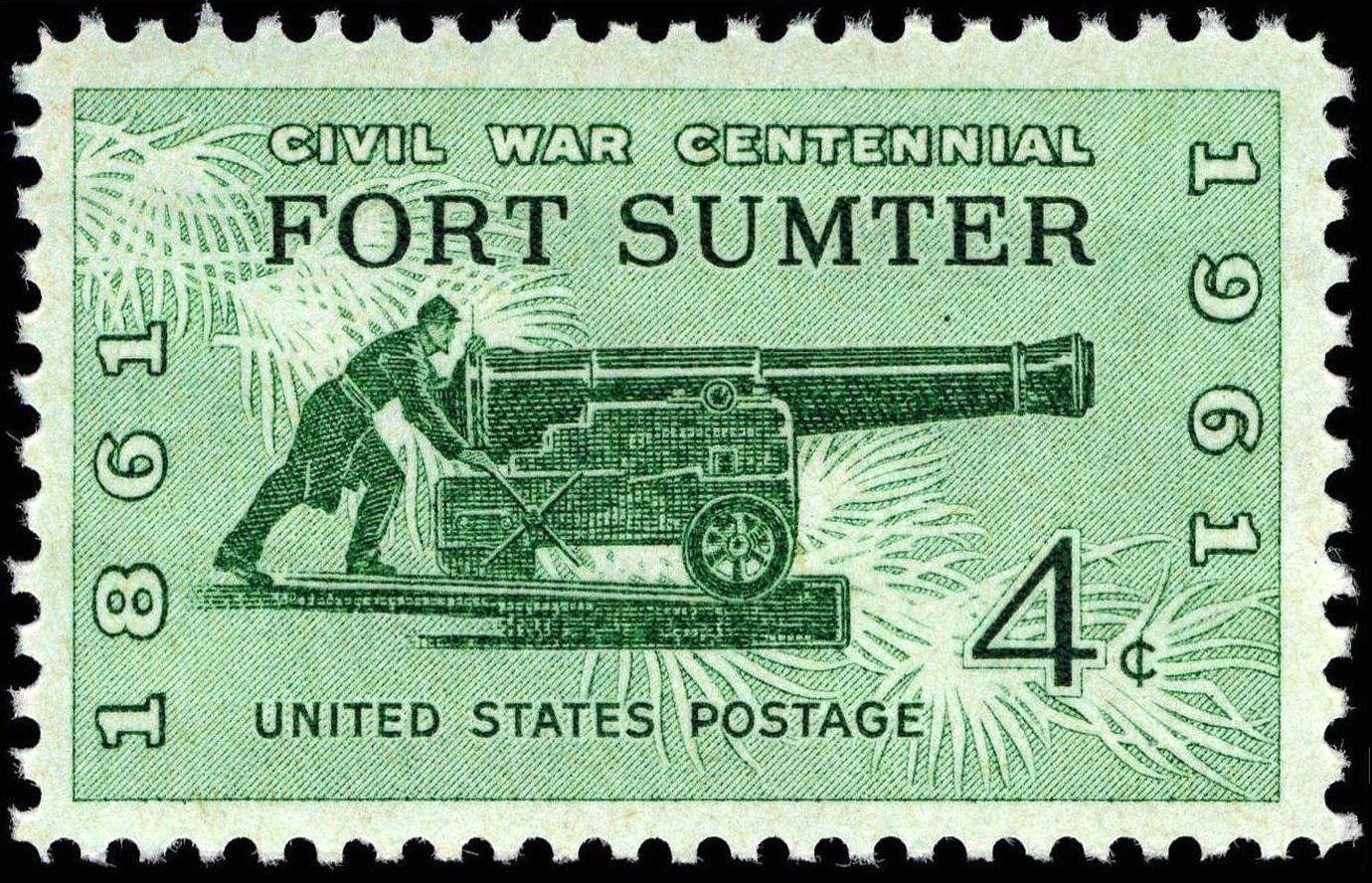
| | | | Fort Sumter As is so often the case, my knowledge of Fort Sumter was there, but really quite minimal. What I knew could be summarized thusly: SC seceded, then fired on Fort Sumter in 1861, which was the incident that started the Civil War. I strongly suspect most people know little more than that. After some pre-trip digging I knew a lot more of the interesting story, supplemented by the experience of the visit and, as ever, post-trip research. | | | | | | I'll insert here, as part of this introduction, this four-cent US postage stamp, released in Charleston in 1961, commemorating the Centennial of the Battle of Fort Sumter, 1861-1961. At first, I did not see the clever artistic device used until it was pointed out in an explanation: the background features bursting shells meant to resemble palmetto leaves.
|
| | | | First of all, I was surprised to learn that the island the fort is on is a total fake. Take a look at this period map of Charleston Harbor (Map by Hal Jespersen) and you'll see why. This shows the fort in April 1861 at the time of the bombardment, but will serve us to go further back to the time of construction to see why the fort is there on its faux island. You see Charleston and the Battery, Fort Moultrie, and finally Johnſon's Fort from the earlier 1733 map of fortified Charleston. You also see something I hadn't realized before, where all the channels in the harbor are located. When the Carnival Ecstasy came into the harbor, it went between Forts Moultrie and Sumter. When our American Star sails in two days, we'll use the same channel. It also becomes clearer why Fort Moultrie was located where it was a century earlier, in the 18C, right on the main channel, and why Fort Sumter was built where it is in the 19C, to act as an opposing bookend.
| | | | It all started after the War of 1812, when the British got close enough to burn Washington and then march on Baltimore, which we'll discuss when we get there. After that war, a series of fortifications was planned and built along the coast, including Fort Sumter, named after a Revolutionary War hero, General Thomas Sumter. Fort Sumter was needed at the entrance to the harbor to cork it up, as it were. Early cannons couldn't shoot all that far and Sumter reduced the effective width of the entrance, and so a faux island had to be built at the required location. Curiously, the landfill was not local. It took 70,000 tons of fill to make the island, and granite was imported from New England, some from as far as Maine. (Does that make it a Northern island?) Work continued up to the crisis year of 1861, when it was still unfinished! It was close, though, perhaps 90% complete. Brick manufacture was farmed out to regional plantations, where slave labor was used to make the seven million bricks used.
http://d1wj0z9v0yrq4t.cloudfront.net/spots/2/271dddf5-13f8-4660-8673-34734d8c8a47_full.jpg
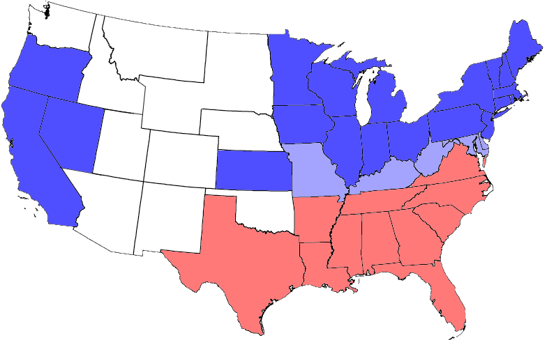
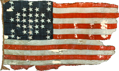
| | | | Although it's a ruin today, the above illustration shows that back in the day it was a handsome—and massive—structure, three levels tall and possibly better described as a fortress. It was five-sided, with the "arrowhead" pointing roughly toward Fort Moultrie, which can be inspected back on the harbor map (click). It was about 52-58 m (170-190 ft) long; the walls were 1.5 m (5 ft) thick and stood 15.2 m (50 ft) over the low tide mark. It was designed to house 650 men and 135 guns in three tiers of gun emplacements, although it was never filled anywhere near its full capacity. | | | | But what surprised me was that, since it was still under construction, as the crisis loomed, it was unoccupied, an empty construction site! But how that changed is a captivating part of the story. After Abraham Lincoln was elected on 6 November 1860, South Carolina seceded from the Union on 20 December. At that point, US Army Major General Robert Anderson and his troops represented Federal power in the area, but he was stationed at Fort Moultrie, which was considered indefensible, so six days later in the dark of night—Christmas night to boot (actually 26 December)--he abandoned Fort Moultrie and, on his own initiative, without orders from any superiors, he secretly occupied the empty Fort Sumter. Considering that Sumter could house 650 men, his relocated small group of 127, 13 of them musicians (!), seems pitifully small, but he thought he could provide a stronger defense here against any attack by SC militia. In addition, fewer than half the cannons that should have been available were in place, due to military downsizing by President Buchanan. Nevertheless, Anderson's US flag was flying over the fort at the entrance to Charleston harbor, easily seen from town in a state that now considered itself to be in a different country. | | | | Remember that, although US Presidents since 1933 have been inaugurated on 20 January, before that, inaugurations were later, mostly on 4 March. Therefore, the events in SC, leading up to the bombardment on 14 April, overlapped two presidential administrations, Buchanan's and Lincoln's. Meanwhile, the rebellion grew, and during January, Mississippi, Florida, Alabama, Georgia, and Louisiana seceded, followed on 1 February by Texas. In February, the seven states adopted a provisional constitution for the Confederate States of America, and established a temporary capital in Montgomery AL. Buchanan protested, but took no military action, fearing doing so would drive the remaining slave states to follow suit. He also acknowledged that, while the US Constitution provided no legal authority for a state to secede, he also felt that neither did it give him any authority to prevent it. During this period, the seven states seized numerous Federal properties within their borders, including buildings, arsenals, and fortifications. | | | | In SC, Anderson's move led to months of tensions between the Federal government and SC. On 31 January, the SC governor demanded Buchanan surrender Fort Sumter to the jurisdiction of SC, a call that was repeated over the next few months, but always ignored. But during that time, Union attempts to resupply and reinforce the garrison were blocked by SC, and the situation began to resemble a siege. During all this time, while Anderson's flag continued to fly, the fort was running out of supplies. | | | | It all finally came to a head at 4:30 AM on 12 April 1861 when the Confederates opened fire on Fort Sumter (notice Anderson's flag in the background). It was a single mortar round from Fort Johnson, which was meant to explode over (!) Fort Sumter as a signal to start the general bombardment, which came in a preplanned counterclockwise order from guns and mortars located at Fort Moultrie (!!), Fort Johnson, the floating battery, and Cummings point (see map). It's ironic to see how the circular nature of the harbor and forts around it worked against Fort Sumter, which was planned from the beginning as a central point. These were the first shots of the US Civil War, and continued for 34 hours. As always, Currier and Ives provided illustrations of the event—this is its Bombardment of Fort Sumter. The action was watched by many civilians in a celebratory spirit, until eventually Anderson and his garrison had to surrender to Confederate personnel at 2:30 PM on the 14th. As unlikely as it might seem, no one from either side was killed during the bombardment. | | | | Anderson's conditions for withdrawal involved the US flag, that he get to keep it (which is why it's in the Fort Sumter museum today) and that it be given a 100-gun salute. There then followed one of the ironies of history. During the salute, a spark blew up a pile of cartridges, killing two Union privates (one was buried right at the fort) and seriously wounding four other members of the gun crew. These two were the first military casualties of the American Civil War, whereas the 34-hour bombardment had harmed no one. | | | | After returning north with the flag, Anderson was considered a folk hero and was promoted to Brigadier General. He retired two years later, in 1863 (more below). Three days after Anderson's withdrawal, Virginia seceded, and in May, so did Arkansas, Tennessee, and North Carolina, bringing the total to eleven, which is precisely what Buchanan had been hoping to avoid. Recently, in 2016/10, we were discussing the five Border States during the Civil War. We'll repeat here the map we used to show now the eleven states that joined the Confederacy (no attribution). We'll discuss flags below, but for now let's say that the number of stars on the Confederate flag started with the original pre-Sumter seven states, then added the four post-Sumter states, making eleven, but then optimistically ended up with 13, in the hope that the two westernmost Border States, Missouri and Kentucky would join, which never happened, so the total number showing 13 stars was a fantasy. | | | | In 1863 there occurred what is called the Second Battle of Fort Sumter, a failed attempt by the Union to retake the fort, resulting in the fort being reduced to rubble, but still in Confederate hands, so the ruin seen today was done primarily by Federal forces. Actually, the confederates never did surrender Fort Sumter. When General Sherman advanced through SC, the Confederates had to evacuate Charleston on 17 February 1865, and so the last Confederate commander of the fort ordered its abandonment, but not its surrender. The Federal government formally took possession of Fort Sumter five days later, on 22 February 1865 with a flag-raising ceremony. The war had devastated Charleston, and the once thriving port was burned and shelled into a virtual ghost town. With slavery abolished, the economy plummeted, but in time, the city was rebuilt and revived. | | | | Two months after the official flag-raising at the fort, a ceremonial one was done on 14 April 1865, four years to the very day after the surrender to the Confederates. Robert Anderson was called out of retirement to re-raise the very same US flag over Fort Sumter he had lowered in surrender four years earlier, which is a bit hard to see (click) in this period photo from the Library of Congress. He raised the flag in triumph over the battered remains of the fort. The Rev Henry Ward Beecher was the principal orator, and gave a lengthy speech, as was the custom of the day, which we also saw at Gettysburg. Later, in the evening of that very same day, President Lincoln would be shot at Ford's Theater. | | | | 1861 Fundraising The pivotal surrender of Fort Sumter and the start of the Civil War brought out a couple of interesting fundraising events in the North, the first involving the Anderson flag. A supply ship called Star of the West evacuated Anderson and all the members of the garrison and brought them to New York City, where they were welcomed with a parade on Broadway. He carried the Fort Sumter Flag with him, today on display at the fort museum. It's 8 ft x 14 ft (2.4 m x 4.3 m)—we'll talk about the number of stars below. It became a popular patriotic symbol of the battle and a rallying point for supporters of the Union. On 20 April 1861, just six days after the surrender, there was a patriotic rally in Union Square in Manhattan. More than 100,000 people crowded the square, in what was believed to be the largest public gathering in the US up to that time. The flag was then taken on a fundraising tour throughout the North where it was frequently "auctioned off" to raise funds for the war effort. The person who "bought" the flag was then expected to immediately donate it back, so that it could be taken to the next rally to continue the effort. | | | | In 2015/16, we discussed the artist Frederic Edwin Church of the Hudson River School, our visit to Olana, his mansion on the Hudson, and also showed his Ecuador paintings. Inspired by the battle and by Anderson's flag, only a few weeks after the attack, and in support of the Northern cause, Church painted Our Banner in the Sky, described as a "symbolic landscape" with the US flag, and placed it on public display. A chromolithograph (color print) was made of it and sold for the benefit of the Union Patriotic Fund, which aided the families of Union soldiers. | | | | Visiting Fort Sumter As the ferry crossed the harbor, we were given instructions about our hour on the island, which was, thank goodness, totally self-guided and very informative. Before we start, let me remind you about a flag situation mentioned when we were in Fort Moultrie. One view of Fort Sumter showed multiple flags, and a second one showed just one. When I stepped into Fort Sumter and walked around, I noticed a discrepancy, which perhaps no one else did. We'll discuss the discrepancy as part of our walkabout.
http://www.performanceimpressions.com/Charleston_SC_scenic_travel_photos_2013/content/bin/images/large/Fort_Sumter_opp6231.jpg
| | | | There are pictures, and there are pictures, and the photo above of Fort Sumter has to be among the best. You see everything here. You know the "arrowhead" on the left points to Fort Moultrie, so the orientation here is facing through the harbor entrance and out to sea. Click to inspect the ferry, and the pier leading onto the island. You see that the ruins have been stabilized and somewhat rebuilt, as compared to the earlier period photo. The reconstructed wall has been pierced by a modern entry leading from the pier. Back in the day, access was via a granite wharf at the back of the fort on the right. | | | | Within the walls, the area is divided in three. The far side is mostly a high terrace, and you see five flags surrounding the American Flag on a taller flagstaff. Look at its base (click). This is the Robert Anderson Monument (Photo by Billy Hathorn) that commemorates his work here, and particularly connected with the flag. This detail photo also indicates the other flagpoles. | | | | Back on our main photo, the near side is a low courtyard, of which, this is a detail (Photo by Billy Hathorn). You can see that the exterior of the fort's walls have been spruced up, while much of the interior of the walls remains in ruins, and even that doesn't apply to the whole perimeter, part of which the high terrace seems to cover. On this side, and to some extent on the far side, you can inspect (click) the architecture and brickwork (Photo by Dsdugan), which can still be quite attractive. This other view of the lower courtyard (Photo by Billy Hathorn) looks in the direction of Fort Moultrie (click), but unfortunately not quite right at it.
http://www.dwhike.com/History/Civil-War/Fort-Sumter-SC/i-FQdmDHB/0/S/Fort%20Sumter%20NM-S.jpg
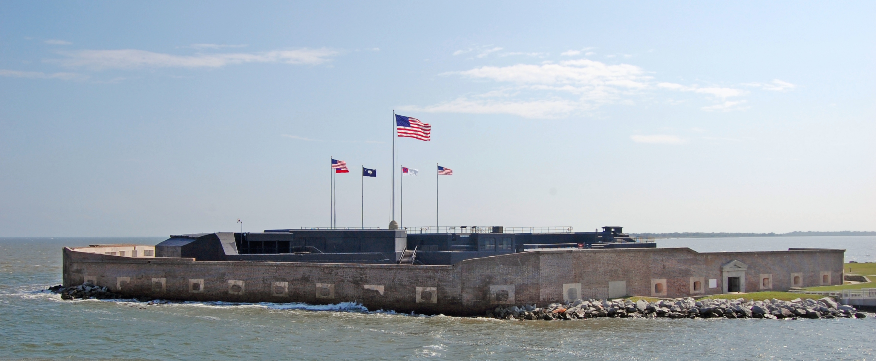
| | | | But in our main picture, you cannot miss the elephant in the room, the ugly, black structure in the middle. The part with the brown roof houses the museum, which shows, among other things, the Anderson flag. Otherwise, refer to the above sketch. It's turned around (the entry is at #1), but it does identify the monstrosity as Battery Huger. (Remember your Charleston pronunciation and say BA.chri yu.GI.) Because it's black, like the WWII area of Fort Moultrie, I can only assume this was also added during WWII and was never removed. Well, at least it houses the museum. | | | | Flag Controversy As I was walking around the fort, I noticed that, where I'd seen pictures of the fort with a cluster of flags flying, five around the US flag, but on the flagstaff with Anderson's monument there was only one. Then when walking in the lower courtyard, I saw a small low-level exhibit of four (not five) historic flags that had flown over the fort during the Civil War, and it was a very interesting and informative exhibit. I knew there had been a recent change—did any other visitor notice the same thing?—but didn't consider why.
| | | | Post-trip research gave me the answer, and I should have caught on. I was well aware of the church massacre in Charleston on 17 June 2015, and had even planned on visiting the site—we'll do so today when we're back in town. I also was very aware of the movement to remove the so-called "Confederate flag" from public display, and that such a flag was removed from the grounds of the SC State Capitol in Columbia three weeks later, on 10 July, to be relocated in a museum. I just didn't associate those events with changing historic flags—not the so-called "Confederate flag" in question—at Fort Sumter.
http://2.bp.blogspot.com/-Ghf-Sd_rQGc/TbLvN-WWDUI/AAAAAAAABEU/ir4AawHvtQY/s1600/Flags%2Bover%2BSumter.jpg
| | | | Look at the main fort picture. Surrounding the modern flag, you see the five additional flags in question, a display which dates from the 1970s. Following a directive from the Park Service to remove Confederate flag items from fort gift shops such as banners, belt buckles, and other souvenirs, on 28 June 2015, the five flags were lowered so that the South Carolina flag—you recognize it in the center in blue—could be then flown symbolically at half staff. Then in August, the five flag poles were removed permanently. | | | | The SC state flag never returned to this Federal facility, but the four historic flags were then set up again in a new exhibit in the lower courtyard. The thinking was this. These are historic flags, even the two Confederate ones—again, not the contemporary one in question. These flags flew over the fort during the Civil War, and it's appropriate to have a museum display of them, down near the museum, and I fully agree. What was felt inappropriate was having the flags up high, where they could be seen over the wall (Photo by Bubba73), as we did earlier from Fort Moultrie, instead of in a museum-like display.
http://glimpsesofcharleston.com/wp-content/uploads/2016/03/20160227_103254-2-1140x694.jpg
https://farm2.staticflickr.com/1452/26064283516_36767cedd3_z.jpg
https://farm2.staticflickr.com/1610/25817358110_7eb8170826_z.jpg
| | | | Thus, all pictures showing multiple flags up above are older than Summer 2015, and the above three are among the newer ones. The first above shows another aerial view, with ferry, but with just one flag, the 50-star modern American flag, high enough to be visible from afar. The second picture shows the new, four-historic-flag exhibit in the lower courtyard, outside the museum in Battery Huger, and localized for fort visitors, not visible from a distance. You see the explanatory marker between them, and that is shown in the third picture. It is indeed a notable museum display, and we'll now discuss this very interesting topic in detail. | | | | The Four Flags of Fort Sumter In order, the flags that flew over Fort Sumter were US, Confederate, Confederate, US, and all were different, for different reasons. The reason the two United States flags were different was that US flags add a new star for each new state, but that only happens on the Fourth of July following the date of the state's admission, which means that it's possible for many months to go by before a flag is changed. That fact is reflected in the two flags listed here, which jump from 33 to 35 stars, even though there were 34 states in the beginning and 36 states in the end. Stay tuned to see why. The two Confederate flags changed because of almost amusingly problematic designs on each of them, meaning a third came about, but never flew here. None of these is the so-called "Confederate flag" we hear so much about. | | | | The first flag to fly over Fort Sumter was, as we know, Anderson's, which at the time was a 33-star United States flag, reflecting Oregon's becoming the 33rd state in February 1859. This flag was valid for two years, from 4 July 1859 to 3 July 1861. We now come to our first anomaly. Kansas became the 34th state in January 1861. The battle took place in April, which means the flag didn't change until July, hence there were still just 33 stars on the flag that flew here. When the 34-star flag did come in, it, too, was valid for only two years, until 1863, but never flew here. | | | | Another interesting point was that after the battle, Lincoln had to decide whether to actually remove stars from the flag because of the seceded states. Of course, that didn't happen, since his whole goal was to preserve the Union. | | | | The second flag to fly over Fort Sumter was the First National Flag of the Confederacy. Presumably to show a relationship with the US flag, called the Stars and Stripes, this actually quite similar flag was called the Stars and Bars (and is the only flag to have had that name). | | | | | | It was designed by a Prussian artist resident in Alabama, and was described as resembling the historic Austrian flag (Image by Skopp), with which the artist would have been familiar. While this is the contemporary Austrian flag, the red-white-red symbolism does go back considerably in Austria. According to German Wikipedia, this is the coat-of-arms of the Austrian Babenbergs and dates to 1512. |
| | | | On the Stars and Bars, the stars represent the first seven states that seceded, pre-Sumter. Post-Sumter, it also appeared with 9 stars, 11 stars (the total of states that actually seceded), and 13 stars, which optimistically included MO and KY. But this flag, despite its famous name, was only used from 1861 to 1863. It's attempting to resemble the US flag was its undoing, since the two flags were so similar that it caused confusion on the battlefield, especially on windless days when the flags were drooping. So, back to the drawing board. | | | | The third flag to fly over Fort Sumter was the Second National Flag of the Confederacy, which bore the nickname the Stainless Banner, which was valid again for two years , from 1863 to 1865. (This flag is mistakenly referred to as the Stars and Bars, which is it not—there are no bars.) For the first time, the upper-left field resembles something that's become familiar, but that's only a part of this flag. It continues with the optimistic number of 13 stars, one in the middle and three on each arm. It's even more amusing why this flag failed—it caused confusion because its long white field looked like a surrender flag. Back to the drawing board again. | | | | | | But time was running out. Officially, it was replaced by the Third National Flag of the Confederacy (Image by Abjiklam), or the "Blood-Stained Banner", at the late date of 4 March 1865. The solution was to add the broad red stripe on the right to reduce the white field. But because of the late date of its adoption, it was never produced in large numbers, saw very little use, was seen by few Confederates, and never flew over Fort Sumter, which had been reoccupied on 18 February. |
| | | | The fourth flag to fly over Fort Sumter was the 35-star United States flag, raised on 18 February 1865. It reflected West Virginia having become a state in June 1863, with the flag changing in July. We now come to our second anomaly. Nevada had become the 36th state in October 1864, but this flag was still valid and flew here, because it didn't change to 36 stars until July 1865. And that only lasted two years as well, until Nebraska became number 37 in 1867. | | | | | | We have to take a moment for a side comment about something I really don't understand. We've just seen the official flags of the Confederacy. But it's this flag that's been causing all the controversy, perhaps most prominently the one that had been on the SC State Capitol grounds and was moved to a museum. The Battle Flag of the Army of Northern Virginia was a square version of the above, and the Army of Tennessee used a similar battle flag. It was modified into this rectangular version to form the Second Confederate Navy Jack from 1863 to 1865. But we're not talking navy here.
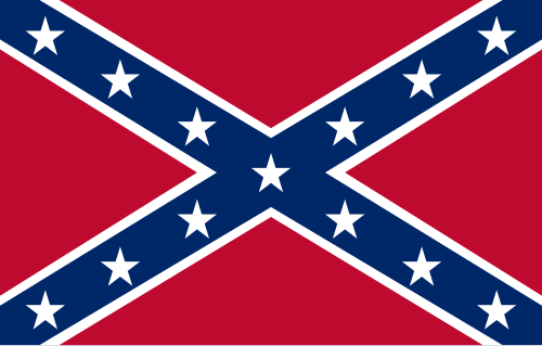
This never historically represented the Confederate States of America as a country, nor was it ever officially recognized as one of its national flags. Still, this is what is commonly referred to as the "Confederate Flag" and is common in modern reproductions. It's also often incorrectly referred to as the "Stars and Bars". As of the early 21C, this flag has become a highly divisive symbol in the United States, some considering it a symbol of Southern pride and others considering it a racist symbol. It would seem to be trying to evoke something that it has no connection to. I see the historic flags as representing the past, but this is nothing more than a divisive symbol.
|
| | | | Mazyck-Wraggborough When we got back to the Maritime Center, I took the yellow DASH shuttle from the Aquarium stop to the Visitor Center (see shuttle map). This was the only time we had activities in one of the boroughs north of Calhoun, Mazyck-Wraggborough.
https://www.google.com/maps/d/thumbnail?mid=1FLq66WaCeAt3jKppBqjfXUcK9Zs&hl=en
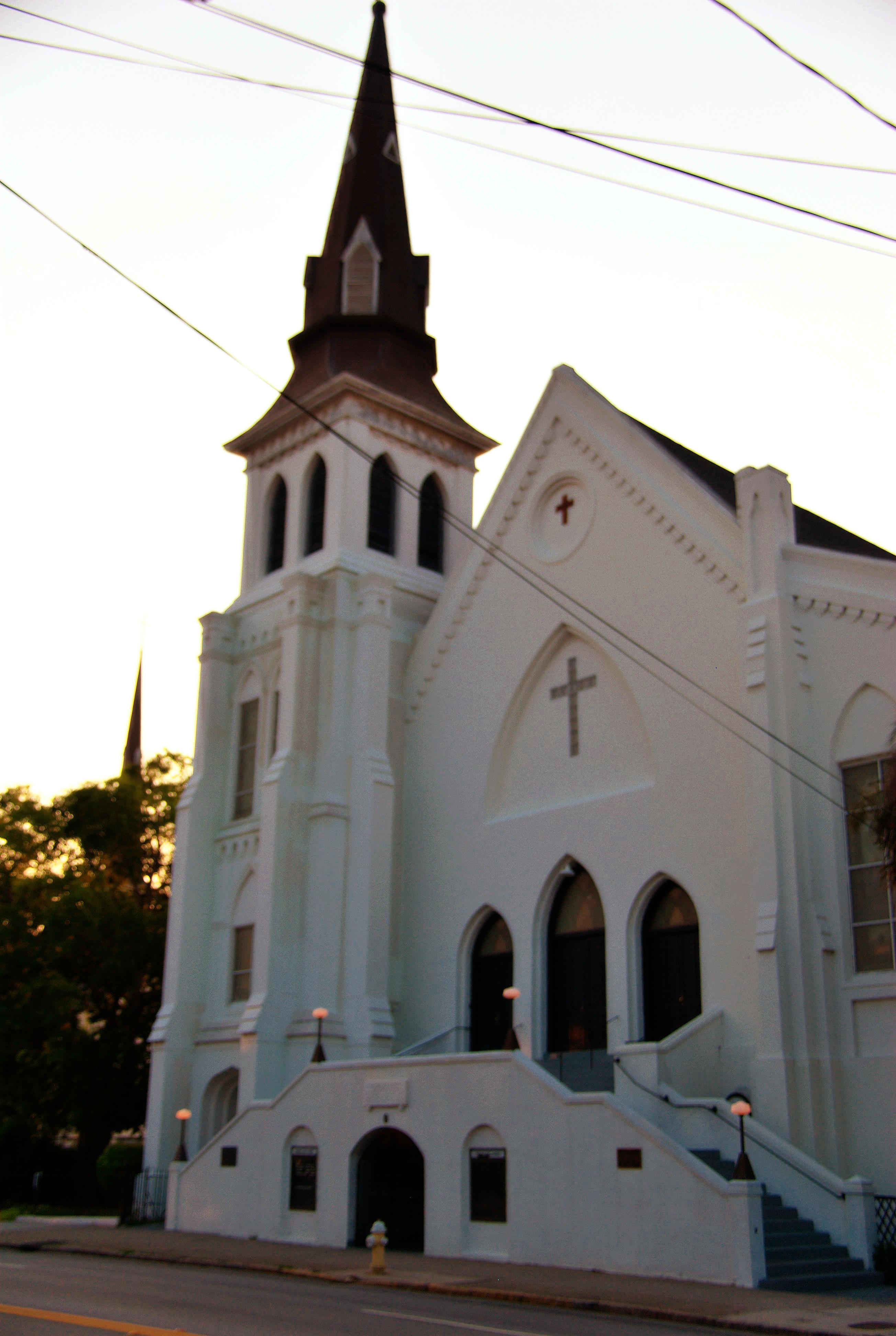
| | | | It was largely developed in the late 18C-early 19C by John Wragg, who gave it the name Wraggborough. This area housed many of Charleston’s first prominent families in a bucolic setting outside city limits. Many of the streets in Mazyck-Wraggborough have Wragg family names such as Mary, Ann, Judith, Elizabeth, Charlotte, Henrietta, John, Alexander. The family lived within the borough for a time, and later donated tree-lined green spaces for public use, such as Wragg Mall Park on Ann & Meeting, and Wragg Square on Charlotte & Meeting (faintly visible on map). | | | | I had time before the Gullah tour at 1:00 and walked along Wragg Mall Park and around the area to see some historic houses. I stopped at Mary and Meeting at the Enterprise office to confirm my rental the next day and my morning courtesy pickup. I also went down to Calhoun to see the site of the church attack (see map) on 17 June 2015 at the Emanuel African Methodist Episcopal Church (Photo by Cal Sr), the oldest AME church in the South and the second oldest in the world. It was not open, but there was a sign in front thanking people for their good wishes. Then it was time to go over to the Visitor Center on the west side of Meeting at Ann. It had a very large tourist bus shed behind it, open at both ends, and that's where my tour was to leave from. We'll discuss that tour (and why I, ever the independent traveler, would take a tour), plus the Gullah and their language, on the next posting. | | | |
| |
|
|
|

