|
Reflections 2016
Series 12
July 23
East Coast III: Ellicott City – Gettysburg
| | Day 3 (later): Ellicott City, Gettysburg 1 Crossing under Baltimore Harbor via the Fort McHenry Tunnel, we stay on I-695 that circles around to the west side of Baltimore, then leave it for a smaller, local road, the only really way to approach historic Ellicott City, on our way to the first of two nights in Gettysburg. We're leaving the Chesapeake Bay area on our little side trip deep into the western Maryland panhandle, but, because the panhandle is so uniquely narrow, we can't help stepping over into nearby Pennsylvania and West Virginia as well. Check that on our Maryland map:
http://www.ezilon.com/maps/images/usa/maryland-physical-map.gif
| | | | Regular followers will note the déjà vu involved in mentioning Ellicott City. The basis for this side trip away from the Chesapeake grew out of the beginning of our recent four-train trip to the Gulf Coast and back (2015/1, "The Gulf Coast by Rail"). The first train we took, after a Northeast Regional from New York to Washington, was the Capitol Limited out of Washington via Harpers Ferry to Chicago. In that posting we discussed the Chesapeake & Ohio Canal fighting its way west, hopefully to Pittsburgh and the Ohio River that begins there, but being defeated by the B&O railroad by the time it reached Cumberland MD. It canceled further construction, and survived for a number of decades only within the state of Maryland. I also admitted "I don't too often describe things I haven't actually seen personally", but did describe the tiny bit of the canal I'd see in Georgetown DC near Filomena's, a favorite restaurant. Well, all that is changed now, as we'll be seeing a lot more of the canal and dining at Filomena's again later on in this trip. | | | | Then, in taking Amtrak's Capitol Limited, we also discussed how it was originally a B&O train, and so we discussed B&O history out of Baltimore and Washington, including the oldest station in the US in Ellicott City, plus the B&O Museum in Baltimore. We'll be seeing that, too, this time around. Obviously, the canal and rail stories got the best of me, so here we are. | | | | So we have the Baltimore & Ohio Railroad and the Chesapeake & Ohio Canal ahead of us in the next days, and more. We discussed the B&O rail history in 2015/1 but that was anticipatory, yet as I reread it, I found quite accurate. I've decided to repeat a condensed—but also extended--version here. And since "you can't tell the players without a scorecard", we'll also repeat here this highly helpful Maryland Rail Map for reference:
http://www.mdot.maryland.gov/Office%20of%20Freight%20and%20Multimodalism/railmap.pdf
| | | | Use the plus (+) to enlarge it as needed, as we compare it to the above regular Maryland map we're holding on the side. Actually, its detail is so good for this area that we'll use it occasionally for non-rail locations. Start with Baltimore and go NE. You'll see both routes we discussed in the last posting crossing the Susquehanna. The Amtrak route is the one we'll take from Baltimore back to New York at the end of the trip. Also be reminded that MARC is the Maryland Area Regional Commuter system here and in this case, its line reaches beyond Havre de Grace to Perryville. Curiously, from Baltimore it stops at Martin Airport, Edgewood, Aberdeen, Perryville, but not HdG. After our Maryland side trip, we'll take the Palmetto to Charleston out of Washington. It'll stop at Alexandria and follow that green line, but the next stop won't be until Richmond VA. | | | | But set the map at 50% on the triangle between Baltimore, Washington, and Harpers Ferry to understand the B&O history condensed from 2015/1, and follow the routes accordingly:
. . . we've already talked about the 1832 LIRR in 2011/19 and the 1832 New York & Harlem in 2011/8. The B&O was not the first US railroad. . . . However, the B&O was (1) the first common carrier, (2) the first to offer scheduled passenger and freight service, and (3) the first intercity railroad in the US. It was chartered in 1827 to connect Baltimore to the Ohio River, as the name says[, conceived as a means of reestablishing Baltimore as a major terminus of inland commerce, a position it had lost because of New York's Erie Canal]. The first train left Baltimore's old Mount Clare Station (now the B&O Railroad Museum) on 22 May 1830, departing Baltimore first to the SW and then cutting off westbound along the Patapsco River valley. The first section went as far as Ellicott's Mills (later renamed Ellicott City), on a now disused stretch. The Ellicott City Station, also dating from 1830, is the oldest remaining train station in the US and one of the oldest in the world, and is part of the above museum.
The first vehicles to run on the railroad were horse-drawn coaches and wagons. This is reminiscent of the 1838 Russian line in Tsarskoye Selo (2014/15). Peter Cooper had built his Tom Thumb, the first American-built locomotive, specifically to convince B&O that steam traction would work on railroads better than horse traction. This was demonstrated in a famous race between a horse and locomotive right in Ellicott City. Even though the engine had some mechanical troubles and the horse won, the engine was adopted anyway and they were used as of 1832.
[The line was extended through Mount Airy, south of Frederick to Point of Rocks on the Potomac, and reached Harpers Ferry VA (WV) in 1834, Cumberland MD by 1842, and Wheeling VA (WV) on the Ohio River in 1852. Wheeling is downstream from Pittsburgh, the original goal of the C&O Canal to reach the Ohio there, but the B&O nevertheless fulfilled the mandate of its name.] . . . In 1873 a line was run from Washington to meet the line out of Baltimore at Point of Rocks, forming a triangle, and from then on, more and more service out of Baltimore went to Washington first before going west. That relegated the top arm of the triangle redundant, and it was then called the Old Main Line (OML). It became a secondary, local route, and then this historic route was abandoned.
Switch to modern times. MARC is formed, and the Baltimore-Washington route becomes its Camden Line (as does the Penn Line), and its Washington-Martinsburg line (no further, at least not for now) became the Brunswick line, passing through the town of that name. Then, the stretch of the OML is reopened for service to Frederick, but the rest, including in Ellicott City, remains abandoned.
| | | | We can further update the above a bit for our visit to Ellicott City. The route from the cutoff in Baltimore (see rail map) to Point of Rocks is now totally for freight, and is called the Old Main Line Subdivision of CSX, which owns and operates it. While the original route directly west was "all about Baltimore'', since this was, after all, the B&O, it's understandable that, once Washington was connected both to Baltimore and to Point of Rocks and beyond, that the most efficient use of the system would be for a train leaving Baltimore to also stop in Washington on the way west, making Baltimore's own route west redundant. I do see a trace of understandable chutzpah and local boosterism in the original route, which then yielded to economic efficiency. | | | | But in the process, history has lost most of the oldest US railroad passenger route to a freight line, not only out to Ellicott City but up to near Frederick. This is how it happened. Passenger service on the OML had become strictly local, and by 1928, only three passenger trains a day used this route. Service was ended totally after WWII. In 1959 the line was reduced to a single track, which is what we'll see today, in order to increase the clearance of tall freight cars through tunnels. Anyway, passenger service on the most historic stretch of rail in the US exists only for that first bit out of Baltimore in red (see Baltimore inset map), plus the red bit south of Frederick to Point of Rocks. | | | | Ah, but I lie. Look at the inset map again. The red line starts at the newer Camden Station, but the original line left from the former Mount Clare Station, now the museum located at the red dot. That means there's a little bit of trackage unaccounted for. And it's owned by the museum, the "oldest of the old", the very first bit of the original trackage, 2.4 km (1.5 mi) of track leading out from the Mount Clare Station (the museum) down to that red line. And we'll get to ride that historic trackage when we're in the museum in Baltimore later. Lots of fun to come. | | | | As we continue on that little side road to Ellicott City, we review the fact that it was a race between canal and rail to rush up the Potomac and up the Maryland wasp waist to be first to Cumberland, Pittsburgh, and beyond. It takes longer to dig a canal than to lay track, and the canal never made it beyond Cumberland. But how the two began is an unusual story in itself. | | | | It was Independence Day, 4 July 1828, when the cornerstone was laid in Baltimore for the Baltimore & Ohio Railroad by Charles Carroll of Carrollton, who was the only surviving signer of the Declaration of Independence. He usually used that extension to his name, including on the Declaration, to differentiate himself from the other Charles Carrolls in his extended family in Maryland. He survived the signing of the Declaration by 56 years and the laying of the B&O cornerstone by four, dying at age 95. At the museum in Baltimore there's an animatronic bust of Carroll that speaks to visitors from beside the original, freestanding cornerstone. Carroll was a huge proponent of railroads and of the B&O in particular. While we'll discuss this more later in Baltimore, the reason the original Mount Clare station is located where it was, a bit west of downtown, later having to be moved to Camden Station, much closer, is because Carroll provided land for it from the estate of Mount Clare mansion (still there), hence the name of the station. The mansion and property had belonged to a distant cousin of his, also named Charles Carroll, a barrister. | | | | It was Independence Day, 4 July 1828 (the very same day!!) when President John Quincy Adams in Washington turned the first spade of earth on the Potomac for the Chesapeake & Ohio Canal. No further details are given about why these two events happened on the same day, but it cannot be a simple coincidence. There MUST have been someone in public relations coordinating this, but I can only speculate. In any case, the race was on! The canal got to use the Maryland shore all the way. The railroad paralleled it, but then crossed into Virginia (today West Virginia) at Harpers Ferry as we saw when we rode the Capitol Limited and will see again when we're there. The rail map shows how it stayed on the VA (WV) side, and it also reached Cumberland first. The canal reached Cumberland eight years later, in 1850 and stopped there. It operated locally in Maryland until a 1924 flood ruined it, and it was closed. More later when we visit it. | | | | So we have both a canal and a railroad running ahead of us up the Potomac Valley on the race westward. And in Ellicott City we are taken aback to find out from several historic markers at the station that there was also a road going west from here, the National Road, and it ran right down Main Street. Three historic routes west, and all going up through the wasp waist! | | | | This was unexpected news, and it took me aback. Post-trip research was necessary, and this is what we found, totally after-the-fact. The project started under the name Cumberland Road, but was then extended both west and east, and is also known as the National Road (Map by Citynoise), the term I'll use, or the National Pike (today each name also appears with the word "Old" or "Historic" up front). And the road is just slightly older than either the canal or railroad. It was the first major improved highway in the US, built between 1811 and 1837 by the federal government. Construction started in 1811 at Cumberland MD on the Potomac, hence the alternate name, and, reached Wheeling VA (WV) on the Ohio, well before the B&O eventually did. But congressional funding ran out and construction was stopped at Vandalia, Illinois, the capital of the Illinois Territory, some distance short of St Louis, which why the name Cumberland Road is limited to the stretch in the map. The reason for the cut in funding was because Congress realized that the railroads were coming and providing better access. Nevertheless, the road was the path to the West for thousands of settlers. | | | | But the west and east extensions of the road did come. In the west, the National Road not only did reach St Louis, but went further, to the state capital, Jefferson City. In the east, a series of private toll roads and turnpikes was completed in 1824, connecting Cumberland with Baltimore, then the third-largest US city. At this point the former Cumberland Road was now the National Road, connecting Baltimore with St Louis/Jefferson City. | | | | But times change. In 1926, when the numbering system of US highways was established, US-40 was among the first of the east-west roads, running coast to coast from Atlantic City to San Francisco (since truncated in Utah), and encompassed much of the old National Road. Later, bypasses were built around towns and there were realignments, including at Ellicott City. Then came another layer of confusion when the Interstate highways were built. As we've seen with Route 66, many of them usurped the routes of older US highways, leaving them in occasional surviving bits and pieces. | | | | Let's peel off the layers going backwards and look for the National Road within Maryland from Baltimore through the panhandle. Oddly, the rail map is our best bet here. While I-70/I-68 followed US-40, which in turn followed the National Road, neither is helpful in determining an original route. US-40, still referred to in Maryland as the National Pike, has been given new alignments, including running north of Ellicott City, so none of that is helpful. | | | | But what we do find out with further digging is that, between Baltimore and Cumberland, what was formerly US-40's original alignment is now called MD-144 (Map by Algorerhythms). Success! But it, too is in bits and pieces, as this map shows. Yet there are two sections of interest. The second red bit from the left is in Hancock in the wasp waist, and we'll be riding on that section later! And better still, the largest remaining section of MD-144 aka the National Road still runs out of Baltimore as far as Frederick MD, although broken up a bit, as seen on the map. And then comes the part about the dumb luck. By pure chance, we're driving to Ellicott City on the original alignment of the National Road as we speak!
| | | | It's most easily seen on the Baltimore insert of the rail map. Follow I-95 through the Fort McHenry Tunnel to I-695 as it swings out west of town. We see up ahead a turnoff for I-70. Forget it. Before that is a turnoff for US-40. Forget that, too, it's a later alignment of the original US-40. Before that is an exit for MD-144, which we'd planned on taking anyway. And by serendipity (OK, dumb luck), the quiet local road we'd chosen earlier on Google Maps (1) just because it's a quiet local road and (2) because we saw it led to Ellicott City, turns out to be on the alignment of the National Road. That we only found this out after the fact matters not a whit. We've ridden on the National Road, and will also be experiencing the B&O RR and C&O Canal in the next days. | | | | The description online of MD-144, plus observation of Google Maps tells it all. Pratt Street is the major east-west street in Baltimore, as we'll see later. It and adjacent Lombard Street form a one-way pair for MD-144 aka the National Road leading west. Coincidentally, Mount Clare Station and the museum are on Pratt Street, so the National Road passes directly in front of the origin of the B&O route, as well as intersecting the rail line at Ellicott City station. | | | | West of Baltimore, most of MD-144 has another historic name, Frederick Road. It's a name that must go back to colonial days, since it actually did lead, as roads named this way did then, to Frederick MD (see upper rail map), although today the name disappears after Mt Airy. The online description has Frederick Road passing through Catonsville and Ellicott City (where it's temporarily called Main Street) to Mt Airy, after which MD-144 is called Old National Pike, so the road still carries its history on its sleeve. | | | | As we approach Ellicott City, we come to the Patapsco River. Then we'll go under the Oliver Viaduct carrying the OML to enter town on Main Street. But we have a surfeit of information here, so let's pause and go back to driving over the Patapsco, for another surprise on my part. We have a picture of the river a bit further north of Ellicott City (see inset map) in Patapsco Valley State Park (Photo by Fritz Geller-Grimm), and, better still, below is the Patapsco right at Ellicott City:
http://switchfisher.com/pictures/2012/2012a/patapsco-ellicot/P6170465.JPG
| | | | They're both bucolic views. None other than explorer John Smith was the first European to explore the river in 1612, and it was river power that ran the former mills here (remember, the old name of the town was Ellicott's Mills). But the river is short, 63 km (39 mi) long, so what importance can it have? For a jolt, look at the map of the Patapsco River watershed (Map by Karl Musser). We know all the rivers leading into the Chesapeake have drowned estuaries, and you see this one on the map. The only thing, though, to my surprise, is that the broad Patapsco River estuary is what serves as Baltimore Harbor, including the famous Inner Harbor! I thought we were seeing the last of the Chesapeake a few moments ago at the tunnel, but in actuality, we're crossing a very different-looking Patapsco a second time within a few minutes. Check the inset map again to confirm this. And furthermore, the river is not as innocuous as it looks above, but is prone to flooding. These are the historic flood stages (Photo by David J Brantley) of the river marked on the adjacent B&O viaduct, facing the town. The most recent one is from 1972's Hurricane Agnes at 4.4 m (14.5 ft). | | | | We'll now go into Ellicott City, but should be aware of these observations. It's among the most affluent communities in the US, and in the past decade has been listed four times among the top 20 Best Places to Live in the US. The historic district encompasses a predominantly 19C mill town dating to 1772, including more than 200 18C-19C buildings. Main street is nice enough, especially the many buildings built with the granite from local quarries. I have one negative point to make about the town, involving serious visual pollution. Historic Main Street in particular is so incredibly defaced by power lines and utility poles that the locals should be ashamed. I'm not including random pictures of Main Street except for the nicer area near the station where the visual pollution is less, though still there.
http://ellicottcity.net/tourism/interactive_map/images/ecroadmap_03.jpg
| | | | Taking up the narrative again, we've been coming down MD-144, aka Frederick Road, from Baltimore via Catonsville—check that out on this town map. We've crossed over the Patapsco, and as you can see, the rail viaduct is IMMEDIATELY facing you, right off the bridge. It's the 1830 Oliver Viaduct (Photo by Scott Saghirian), named for Robert Oliver, one of the original founders of the B&O. The station is immediately to the left, as is the route to Baltimore; to the right is the route west. You can see some of the fine granite buildings on Main Street beyond, though including poles and wires. I now learn from the Maryland State Archives online that this viaduct was originally a stout, triple-arch structure, but in 1868, the two northern arches (on the right) that spanned the Baltimore & Frederick Turnpike (National Road, Main Street) were replaced by the current steel spans, though the third original arch remains to the left of the left pier. It spans the tiny Tiber River, a local creek.
https://2.bp.blogspot.com/-QJxxkEMyz6g/Vwm2D-rTArI/AAAAAAAAEis/Nx_aFL0ciYkF2YIdHqap139uzJqEPTnDQ/s1600/Oliver-Via%2Bn.gif
https://bridgehunter.com/photos/28/42/284208-L.jpg
| | | | The first picture, unfortunately tiny, shows the entire span. Since the entire viaduct at the edge of the Patapsco reminds me of a medieval city wall, I think it would have been much more authentic to have kept the three granite arches. You see a bit of the station on the left. The second picture is the view of the graceful arch and creek from INSIDE the "city wall". You see both the location of the marker showing flood stages, but also the extreme closeness of the Patapsco and the bridge we just drove over.
http://static.panoramio.com/photos/large/105660962.jpg
| | | | Although this picture repeats much of what we just saw, I like it, despite the visual pollution of the power lines at a historic site. It's our first view of a good part of the station, and shows how the lower level is below the tracks (entrance on right), with an interior staircase needed to reach the upper level and trains. But I like this little park-like plaza in front of the station, (there were leaves on the trees in May) because of the historic signs you see displayed. These are the signs that first alerted me to the fact that Main Street, in the foreground, had been the National Road, but also gave me some very interesting statistics about early rivalry between road and rail. | | | | The road arrived here first, and the train line crossed it a little later, and we're looking here at the intersection of the two rivals. The road had thrived for a couple of decades before the B&O, but by 1840, the handwriting was on the wall. By that year, the stage coach from here to Cumberland on the National Road cost $9, but on the B&O it cost only $7. Worse, the road trip took 20 hours, but the train trip took only 10. The last straw was that the road was horrendously rough and bumpy, while the train ride was smooth. The road was doomed. Thus, it was here at this intersection that I read about why road funding at that time was cut at Vandalia. This little intersection taught me a lot about early transportation. | | | | Check the town map again. Although we'll leave later down Main Street, our only interest is Maryland Avenue, that first left turn after the viaduct, which is adjacent to #5, the historic Ellicott City station. I remember noticing Tiber Alley at the time, and now realize it's somehow related to the creek. We were warned in advance that parking is very tight, but are lucky to get a spot right on Maryland Avenue, shown here looking south from Main Street past the station entrance, with leaves on the park trees as they actually were in May. When you walk straight ahead a bit and turn around, you see the north view back up Maryland Avenue to Main Street (Both photos by Payton Chung), with its granite-block buildings (and wires). | | | | The Ellicott City Station is built against the adjacent viaduct, so both date from 1830. It's the oldest remaining passenger train station in the US, and one of the oldest in the world. Like nearby buildings, it was built from stone from quarries owned by the Ellicott family, which had founded the town and local flour mill in 1772.
http://www.trainweb.org/oldmainline/oml/140elli1.jpg
| | | | This view shows the west façade on Maryland Avenue, including the main entrance in the center, and also the south façade up on the track level, including the doors to what had been the service area where engines could be pulled into the building for servicing, so that they could be worked on from the lower level. | | | | We enter the station and buy a reduced-price combination ticket for this as well as the main museum in Baltimore, good for six months, since we'll be there in a couple of weeks. A volunteer shows us around the interior rooms, downstairs and upstairs.
http://beyondtherim.meisheid.com/wp-images/Station.jpg
http://home.frognet.net/~mcfadden/wd8rif/img/ellicott_depot3.jpg
| | | | Both these views are of the north façade from the Oliver Viaduct, as a train headed toward Baltimore would have seen it, as well as of the east façade facing the track and river. We sadly note that the original double track is now single-tracked for freight. Also showing is the original name of the town and station, Ellicott's Mills. On these and earlier pictures are what was apparently a staircase directly from the street to the platform, but I was given no details on that.
https://dianabaileyharris.files.wordpress.com/2012/08/img_9729.jpg
| | | | We go out on the platform and walk its length. Sadly, again, a stout fence separates us and the station from any actual access to phantom passenger trains. This time from the upper level, we're again seeing the south façade, with its doors leading to the maintenance area. We'll see these doors again shortly. | | | | We'll mention again that the inaugural trip from Baltimore here was on 22 May 1830, using horse-drawn wooden rail cars, but we never mentioned before that the trip was for the B&O Board of Directors, and that it took place on wooden tracks! More below about wood. It and subsequent trips took an hour and a half. Peter Cooper had built his Tom Thumb (we'll see the replica in Baltimore) to convince the B&O that steam traction would work better, and raced it against the horses. Due to mechanical problems with the engine, the horse won, but steam was adopted anyway starting in 1832, although it wasn't until 1836 that they stopped using horses. | | | | It's worth comparing first railway experiences in Ellicott City and the Russian experience in Tsarskoye Selo (and a bit further to Pavlovsk) (2014/15). Construction began there in 1836, also with horse-drawn vehicles. Steam followed in 1837 on weekends only, and in 1838 full-time. While the full distance from Saint Petersburg to Pavlovsk was 27 km (17 mi), it's worth making the comparison between the more important Tsarskoye Selo on the way at 23 km (14.5 mi) and the line from Baltimore to Ellicott City at 21 km (13 mi). Surprising similarities. | | | | The importance of the Ellicott City station was substantial, right through the Civil War, when troops were stationed here to protect it as a vital hub. Check the Maryland map to see how close Gettysburg and Antietam (not shown, but south of Hagerstown) were. After those battles, prisoners were held here at the station and the dead were shipped home through here. But, despite all the history, the last passenger train stopped here in December 1949, and now just freight passes through. And perhaps a phantom Civil War train. | | | | Use of Wood One of the advantages of historical travel—and that's just what this is—is to be able to get into the mind of another era. They thought differently, and we should look into that, both regarding wood and horses. Wood first.
| | | | All vehicles in 1830 were wooden. On water, think of wooden ships, on land think of wooden wagons and coaches. (When we visit the Wright Brothers later in the trip, we'll see that even their first plane was wooden, and that was 1903!) Today, everything dealing with transportation is metal, with the occasional item made of plexiglas. So while we see metal train coaches/carriages today, we should not be surprised that, when we see a picture of a replica of the first B&O train car from 1830 in a moment, we won't be surprised to see that it's wooden, as were coaches for some time after that. | | | | We'll also be discussing below the words "rail" and "track", but for now, let's just say that when the B&O—and other early railroads--decided to lay track back in the day, while they realized the strength of metal, which they eventually changed over to, it seemed perfectly normal to first consider wood, which was much cheaper, and renewable. And so the B&O laid finished hardwood timbers along the route. But there was a variation: strapping.
https://s-media-cache-ak0.pinimg.com/236x/1c/b2/0b/1cb20b6b613586da61ffd5fc83e22753.jpg
| | | | With wooden wagon wheels, as above, it's obvious that the outer wood surface would wear away quickly, so frequently a metal strap went around the wheel to protect the wood and bear the brunt of friction. Therefore, this process of strapping wood was also extended to these new rails that were being laid, resulting in what is known as strap rail, new then, unused today, and very rare to find examples of. This illustration includes an example of strap rail in the center. Left to right you see the crosstie or sleeper, and you're looking straight on at the end of a wooden rail. Lying on top of it on the inner edge is the strap. Thus a wooden coach/carriage wheel resting on a wooden track actually involved metal-on-metal. This display (Photo by Z22) hangs on the wall inside the Ellicott City Station. You see the hefty spikes that attached the strap to the rail, and if you click, you'll see that it says that this is a section of strap rail used in the early Cog Railway at Mt. Washington (NH, 2006/12) between 1866 and 1874. I hope you see the inaccuracy of the display, at least as it applied to the B&O. It shows only the strap, attached to a display board, it doesn't show the wooden rail itself as the B&O used it. | | | | But these were quickly replaced, first by cast iron rails, then steel rails, and the reason is surprising. Hold a length of ribbon in one hand and hold the other end between your thumb and a knife edge and pull, like you probably do for holiday packages. What happens? The ribbon will curl in the direction of the metal blade. Unfortunately, so did the strapping on the rails, after sufficient wheel friction. The strapping would even tear out the spikes as it curled backwards, often penetrating the carriages. Such a loose, bent-up end of a strap rail suddenly curling backward over a wheel and piercing the bottom of the car was called a "snakehead", and threatened passengers sitting in the wooden coaches with possibly serious harm. This led to the end of strap rail in favor of full-metal rails. | | | | Use of Horses The advent of the 20C not only saw metal vehicles taking over wooden ones, these vehicles were self-powered, and took over the use of horses. So we have to move back to 1830, when the horse was still king. Horses pulled all land vehicles that weren't pulled by mules (on canals) or oxen. And don't forget the Pony Express of 1860-1861 (2016/1). So when rails were first put down in city streets what had been horses pulling wagons became horsecars, the only difference being the new-fangled tracks. This 1908 postcard shows an 1877 horsecar in Manchester NH—wooden, of course. So if horses trotted along city streets pulling these wheeled cars on tracks, why not have one run from Baltimore to Ellicott City, or from St Petersburg to Tsarskoye Selo? It makes perfect sense when you look at it in the proper context.
http://www.rgusrail.com/thumbs/mdboroundhouse/bo_pioneer_03.jpg
http://www.victorianweb.org/cv/rrmuseums/baltimore/12.jpg
| | | | So we now get down to the real thing (above), the first B&O "train"—or horse-drawn car--appropriately named the Pioneer. Still, if it had been running on city streets at the time, it probably would have just been called a horsecar. Also, it was a white lie to call what we see here the real thing. The original Pioneer was scrapped at an unknown date, and this is a "modern" replica on display at the B&O Railroad Museum in Baltimore. And that statement is also inaccurate, as the replica itself is a century-and-a-quarter-old antique, having been built in the Mt Clare workshops in 1892. It also has a fine pedigree all its own, as it was built to be displayed at the 1893 World’s Columbian Exposition in Chicago, followed by the 1927 Fair of the Iron Horse, the 1933-34 Chicago World's Fair, 1939-40 New York World's Fair and 1948-49 Chicago Railroad Fair. Not bad. | | | | We'll mention it again when we're at the museum in Baltimore, but take a look at the two above pictures. The Pioneer is wooden, of course, and pulled by just one horse. Though today we measure engine output in horsepower, we can say that the Pioneer ran on one horsepower. The first picture shows best where the coachman sat, very much like on a stagecoach. The second picture shows better the three-window length of the car. You can also see the step at the back, since there is an opening in the back, without a door, that serves as an entrance. The seating consists of wooden benches on each side, and you can actually enter the car today and have a seat to experience 1830 once again. Just be careful of any snakeheads popping through the floor. | | | | The relationship between rail cars like this and urban horsecars was ongoing. When the B&O stopped using horses to pull trains in 1836, it continued to keep horses in its stables at Mt Clare until the 1880s to pull horsecars through Baltimore.
http://www.shorpy.com/files/ecbo_1.jpg
http://1.bp.blogspot.com/-HMV_IylXIF0/TzFOFnWoIbI/AAAAAAAAAOE/05teH_KADZA/s1600/The+Pioneer.jpg
| | | | I said earlier we'd bring the story back to Ellicott City and its service area on the south façade, and here we are. I did not see this myself, but read later that the station also has a replica of the Pioneer. Since it wasn't there, and I didn't know it should have been at the time, I couldn't ask about it. I can only assume that, as with any museum display, it was perhaps being serviced. Still, the open doors show the size of the workshop. The purpose of the second picture is to show the contrast between the Pioneer and a modern, double-decker freight car. Given its size and need to get through tunnels, you can understand why the route has been single-tracked. | | | | Rails and Tracks In 2014/3 we discussed the origin of the English word "train" (also in other languages), which is the same in French and derives from traîner (tren.É), "to drag, to haul", and by extension, "to pull", which is otherwise tirer (ti.RÉ). (I am also SO tempted to translate traîner using the New York Yiddishism "to schlep", derived from German, since it can be used in the same way.) But talking more specifically about wooden rails now, the discussion leads to "rail" and "track" in English.
| | | | While "railroad" and "railway" are synonymous, the Online Etymology Dictionary states that "railway", more common in Britain, appeared first, in 1812, in the modern sense of applying to passenger and freight trains, with "railroad", more common in the US, appearing in 1825, both dates falling within our time frame. But more interesting is what exactly the imagery of this "rail" was that was laid on a "road" or "way". The original meaning of "rail" still remains with us today, when we look at a rail fence (Photo by Elf), also called a split-rail fence. They were traditionally used for agricultural fencing, but while they may be old-fashioned today, because of their rustic look, they're still used for decorative purposes. We'll refer to them again during the Battle of Gettysburg. While the (split-)rails may be rough-hewn as in the above fence, they can also be set into mortises in fence posts, such as here (Photo by Max Wahrhaftig), resulting in a neater, though less rustic, look. | | | | A person who splits rails is called a rail-splitter, although that term is today almost exclusively applied to Abraham Lincoln, since it was used in his political biography in the day to point out his "everyman" persona. This picture actually shows a rail fence in the background, just in case some constituents missed the reference. In Garfield Park in Chicago there's this statue of a young Lincoln as a rail-splitter, and we have to include this 1865 political cartoon. It shows Vice President Andrew Johnson, a former tailor, and Abraham Lincoln, the "rail-splitter", during the Reconstruction era of the US. While Lincoln is using a split rail to position the globe, Johnson sits atop it, using needle and thread to stitch together the map of the US (click).
| | | | The imagery of using a rail as a guide reflects back to the appearance of "railing" between 1350-1400 to refer to a balustrade or banister, and a "hand-rail", which appeared in 1793, was also a guide. So while most vehicles move about freely, when trains appeared as the only vehicles directed to their destination by guides embedded in the ground, especially considering that (fence) rails were so common, it would have been perfectly logical to also call these guides rails, especially with the earliest tracks actually being made out of wood. | | | | But that imagery has weakened. While many people would consider phrases like "plastic glass" or "plastic silverware" to be apparent oxymorons, few might consider "steel rails" to be one, no longer seeing the metal/wood imagery. | | | | And just a bit about "track", and how its rail imagery that we accept so readily is absolutely backwards. A person, animal, or vehicle leaves tracks behind it, after the fact of passage. Usually invisible, such tracks can appear in snow, mud, or soft earth. Let's limit that to a wagon leaving tacks in the mud AFTER it passes by. But as of 1805, the word "tracks" began to be used to describe the rails that are laid down well BEFORE a train appears. If that isn't a reversal of imagery, I don't know what is. | | | | Battle Rationale We leave Ellicott City down Main Street and head northwest toward Gettysburg. See the rail inset map to see how US 29 gets us up to I-70 westbound, and then the main rail map to see how we get off all that hustle and bustle to cross Maryland countryside northbound on MD 97 to Westminster. Switch to the main MD map to see how 97 (not named) then crosses the border into Pennsylvania to Gettysburg. It's not that long a drive, and we arrive mid-afternoon. | | | | Since this is a side trip from the Chesapeake to follow rail, canal, and road travel routes up the very narrow Maryland panhandle to Cumberland, we need to justify what looks like a side trip off of a side trip, which it really isn't. Everything in this geographically unusual area is cheek-by-jowl, even if over state lines from Maryland into Pennsylvania (Gettysburg) and from Maryland into West Virginia, formerly Virginia (Harpers Ferry). To this we need to point out how the Civil War, most of whose battles we associate with having taken place in the South, burst through this area, step-by-step, first to the northern border of VA (WV), then MD, then PA. | | | | We first mention Bolivar Heights, above Bolivar, which is Harpers Ferry's adjacent sister town to the west. The Battle of Bolivar Heights took place in 1861 (16 October). This was VA at the time, now WV. The next year, things heated up. The Battle of Harpers Ferry took place in 1862 (12-15 September) and destroyed the town. Two days later, the war moved for the first time onto definitive Union territory, the border state of Maryland, with the Battle of Antietam (not on this map, but just south of Hagerstown) on the 17 September. Then the following year, General Lee decided to bring the war even more definitively into the North, even beyond the border states and beyond the Mason-Dixon Line, and invaded Pennsylvania in the Battle of Gettysburg in 1863 (July 1-2-3). It's not far across the border—I suspect not many people realize how close to the Maryland border Gettysburg is. | | | | Gettysburg 1 (Half Day) I continue to be amazed at how return trips tend to be better, sometimes exponentially, than original trips, and mention Chesapeake City as only one example. Gettysburg will now be another. Beverly and I, during one of our Grand US Tours in our VW Camper, stopped in Gettysburg, according to our travel diary, on 19 July 1969. We were swinging south from Harrisburg PA, stopped for several hours to do the complete battlefield driving tour, then continued on to Frederick MD and beyond. I'd always felt we'd done a good job having the Gettysburg experience, and realize now how much fuller it can be. Is it more travel experience? Access to online information and maps? Whatever it may be, it's more of a complete experience now. I also see we made a grave mistake in 1969. Thinking the battlefield was all there was to see, we never went into town. Now I think the town has just as much to offer as the battlefield driving tour. | | | | Basics: Samuel (also reported as James) Gettys settled here at the crossroads where a road from the NW went down to the SE to Baltimore, and intersected with an E-W rod between Philadelphia and Pittsburg. He ran a tavern in 1761 for soldiers and traders. As a minor point, his name was pronounced GET.iss and not GET.iz, and the town's name follows suit. Jump to 1858 when the Gettysburg Railroad completed a line connecting Gettysburg to Hanover and the larger network (see rail map). The Gettysburg Railroad Station opened in 1859, a point at which the town had about 450 buildings. Four years after that, Lincoln would use this line and station on his visit. The now (unfortunately) disused but (fortunately) restored station is today called the Gettysburg Lincoln Railroad Station and is presently included within the boundary of Gettysburg National Military Park.
https://irp-cdn.multiscreensite.com/fd5107cc/dms3rep/multi/desktop/TGE%20New%20Map%20Layers-776x936.jpg
| | | | Gettysburg still looks a lot like the 19C town it was at the time of the battle, but that's not its only charm. While most towns are built around a Main Street, as in Ellicott City, or, say, Delaware Avenue in New Castle, Gettysburg early on developed a distinguished town plan. The above map (click) intrigues me for what it shows, even though it leaves out a lot. The bulk of the battlefield is to the south and is maybe 2-3 times the size of the town, but it's squeezed here to nothingness. Along with this distortion, the bypass road, US-15, here in purple, is much further away from town than shown, and the road we're arriving on, Baltimore Pike, is bent here like a broken branch—it actually comes from the SE and gradually flows into its new identity as Baltimore Street. These map flaws irritate me, but the center of town is shown here perfectly, and that's what we're using this map for. | | | | The center of town is not a "main street", but a square, which actually is a geometric square. It was originally named Central Square, and later became Lincoln Square, and you know why. From here, main roads spread out as in a sunburst, with the street grid filling the spaces between them. And what's so charming is that most of them lead (or used to lead) to the places the roads are named after, just as we'd seen with Frederick Road leading out of Baltimore. | | | | While some of these roads may have since altered their names further out of town, or even within, they originally did lead to where they say. Chambersburg Street, despite intermediate names, leads to Chambersburg Pike and Chambersburg PA; Carlisle Road does lead to—or towards--Carlisle PA; York Street leads to York PA, Hanover Street leads to Hanover PA, which the rail line also connected to, Baltimore Street leads to Baltimore Pike and Baltimore. There are others of importance we'll mention shortly; for now, just notice Steinwehr Avenue and keep it in mind. | | | | You can see exactly where the railroad, now just for freight, comes into and goes out of town, with the historic station shown by a green square. The David Wills house, that we'll visit shortly, is not shown, but is on the SE corner of Center Square/Lincoln Square, with the entrance on York Street. On the north side of town is Gettysburg College, founded in 1832 as a sister institution to the 1826 Lutheran Theological Seminary, shown on the left. This is the institution that gave its name to Seminary Ridge, where the Confederate line of battle formed to the west of the battlefield. At the dedication of the National Cemetery the President of Gettysburg College gave the benediction, speaking after Lincoln gave his Gettysburg Address.
https://irp-cdn.multiscreensite.com/fd5107cc/import/base/battlefield.jpg
| | | | This regional map is much better to show the surrounding area, but not the center of town. You can see that the battlefield is primarily to the south of town, although also somewhat to the north and west. Many of the famous battlefield locations are mentioned here, but I want to point out two things. You'll see in the center Evergreen Cemetery, which predates the battle. It gave its name to Cemetery Ridge, the stronghold of the Union here in the east. And on the left is the Eisenhower National Historic Site, the home and farm he and his wife retired to, and the only home they ever actually owned after living a lifetime on military bases. Here they entertained, Churchill, DeGaulle, and Khrushchev. They donated the home to the NPS in 1967, with lifetime living rights. Two years later, he died at age 78, and she died ten years after that. It can only be accessed by shuttle bus from the NPS Visitor Center, which I declined to do, since I'd just been to the Eisenhower grave in Abilene KS (2016/2). | | | | Beyond that, I have more to say on this map about roads, which appear here again in a rather symmetrical sunburst pattern, if not a spider web. Or do they form a stick figure? All those we mentioned above are named here, as well as Old Harrisburg Road in the one o'clock position, leading to the state capital of Harrisburg; Fairfield Road at eight o'clock, leading to the nearby town of Fairfield PA; at six o'clock Taneytown Road leading to Taneytown MD, and, passing through the battlefield even more crucially than the Baltimore Pike is, at seven o'clock, Emmitsburg Road leading to Emmitsburg MD (these last two emphasize how close Gettysburg is to Maryland). For some reason I cannot determine, it was Emmitsburg Road whose upper end within the town was renamed Steinwehr Avenue. I do know that Baron Adolph von Steinwehr was a German-American Union General, and on the battle map of Pickett's Charge he did command the northern edge of Cemetery Ridge near this road, but I don't know why he's the only one a road was named after. Anyway, I'll continue to refer to the entire thoroughfare as Emmitsburg Road. | | | | Now I can mention something else. We're not looking at these roads because of the simple esthetics of a sunburst pattern. One reason Lee picked Gettysburg as the town they wanted to conquer was because of the road system. If they took Gettysburg, they'd be well positioned to move on these roads in any direction, though most likely on the road to Harrisburg as the state capital. If that had happened, what next? Baltimore? Washington? Philadelphia? New York? | | | | Back to the regional map and the narrative. As we drive up the Baltimore Pike, the plan is this. We have half a day now, and we'll use it to see the town. Tomorrow will be the driving tour of the battlefield, and any extra time there will be for relaxing and writing. But at the moment, the only thing we need is the (free) current NPS map of the drive. The (new) visitor center is the red star on our map, so now would be a good time to pick up the driving tour map for tomorrow. Still, as we're driving up the Pike and living in the present, we realize that the Park is on both sides of us, and find cross traffic for those visitors already on the tour between Park sections, and having their heads in the past. Present and past crossing like this is an unusual feeling.
http://www.gettysburg.com/visitor/images/downtown.gif
| | | | But as we arrive from Ellicott City in the Baltimore area, we're on Baltimore Pike, and the name just makes so much sense. It soon becomes Baltimore Avenue and we're downtown. We'll use this modern map now, whose only defect is the odd way it shows Lincoln Square. But we make a right one street earlier onto East Middle Street, which is actually a major street—it's the one that becomes Fairfield Road in the west, which is the way we'll leave in two days. Barely a half-block in we're at the Gaslight Inn B&B, where we're booked (shown on map). As ever, location, location, location.
https://media-cdn.tripadvisor.com/media/photo-s/01/b8/88/58/the-front-of-the-gaslight.jpg
https://media-cdn.tripadvisor.com/media/photo-s/01/b8/88/59/front-porch.jpg
| | | | It dates from 1872, so it wasn't in the Battle and postdates it by nine years. The first picture looks west down Middle Street towards Baltimore Street. The second picture better illustrates its extensive side porch, which is actually the entrance that is used. As we register in one of the several downstairs public rooms, we're offered afternoon pastries and coffee. While we found this location quite early on, contrary to our custom, we registered relatively late, but were lucky. There was plenty of availability for the Thursday night, but—what luck--the desired, less expensive room was the only one left for Friday night, part of the busier weekend.
http://www.thegaslightinn.com/stay/accommodations/violet/files/Violet002520Room04.jpg
http://www.thegaslightinn.com/stay/accommodations/violet/files/Violet002520Room01.jpg
| | | | I do not memorize the names of my rooms in B&Bs, but some special names just stick in the mind. I still remember staying in the Cunard Room in Windsor NS, and the Back Creek Room in Chesapeake City. And here, when I'd first heard the room I wanted was called the Violet Room, that name stuck in mind, too. And, as these two pictures show, violet it was, and lilac, mauve, lavender, plum, purple. Not only was it as attractive as I'd expected, the colors, especially of the walls, were very restful. I know I'll remember the name of this room, too.
http://www.thegaslightinn.com/index_files/stacks-image-8799376.jpg
| | | | It's only mid-afternoon, and we want to see the town, but let me first say this. On the first morning, there was only one couple to join me at breakfast, at the large table above. Actually, I sat at the very place in the foreground, and we had a very nice conversation. On the second and last day, I realized why there was no additional availability. I'd been told that the inn was often used for weddings and graduations, and this was graduation week at Gettysburg College. One single party filled the house. All the seats at this table were filled, and a similar table was set up in the living room. The father told me his daughter was graduating from the College, that he booked this B&B regularly to visit his daughter, and had booked this entire weekend a year ago, to be sure to include his entire group. But to my advantage, he hadn't needed the Violet Room. | | | | Back to our arrival. We're given a parking space behind the Inn, unpack, and hightail it to Lincoln Square, just 1 ½ blocks away. The David Wills House there is open for a couple of hours more, and we visit it. We then walk up Carlisle Street 1 ½ blocks to see the Gettysburg Lincoln Railroad Station. Since the history of these two stops fits in chronologically four months after the Battle, we'll discuss them later in proper sequence. Otherwise we walk around town, have dinner right on Lincoln Square with a nice view, and amble around town reading the numerous historic markers. Since my motto is never to let a historic marker pass me by, we have a field day. | | | | The first few blocks of Chambersburg Road seem the most interesting, both for period buildings and markers. Typical markers tell about hiding in cellars during the three days of the battle, taking care of wounded, and the like. The marker I remember best, was also somewhat amusing. It told how, during the temporary occupation, some Confederates were in Center Square and, needing items from shops, purchased them, which I thought was novel. However they paid with Confederate currency, which the town merchants had absolutely no use for! | | | | The Battle of Gettysburg There is no intent here to fully portray the Battle of Gettysburg, about which volumes have been written. Our intent here is to give the necessary bare-bones framework for visitors--either real or virtual (armchair) visitors—to follow events and make the visit memorable. | | | | There had been Union losses earlier in 1863, at the Battle of Chancellorsville, and Lee and his Army of Northern Virginia wanted to take strategic advantage of that by physically invading the North for the second time after the unsuccessful Battle of Antietam. This time they symbolically wanted to reach into Pennsylvania, even if ever so slightly. He also wanted to take the pressure off of Vicksburg (2015/7) and be able to get supplies from Pennsylvania farms, since the Virginia ones were so ravaged. His goal would have been the state capital at Harrisburg, then beyond that, and Gettysburg's extensive road system could get him there. On the Union side, the Army of the Potomac was at first commanded by General Hooker, but at the very beginning of the start of battle, he was replaced by General Meade. So, while numbers reported do vary, as the three-day conflagration started (1-2-3 July 1863), it was 93,700 Union troops under Meade against 70,100 invading Confederate troops under Lee, fighting primarily across the fields and heights south of town. It was during some of the hottest days of the summer, and ironically, it was on the third day, 3 July, during the infamous Pickett's Charge, that was the hottest time of that month, nearly 90°F (32°C). In any case, Gettysburg is the site of the bloodiest battle of the American Civil War with 51,112 casualties on both sides combined, which breaks down to 23,049 Union and 28,063 Confederate. Of that casualty total, some 20,000 were wounded. This means that nearly one-third of the total forces engaged at Gettysburg became casualties. Meade's Union Army of the Potomac lost 28% of its men, and Lee's Confederate Army of Northern Virginia lost over 37%. This event now makes Gettysburg one of the most visited places in the US. | | | | We've been talking about physical geography, having traveled from the coastal plain across the piedmont to this more mountainous area, and Gettysburg exhibits that. It's noteworthy that much of the fighting at Gettysburg involved armies poised on hilltops and ridges, and this physical map shows why. While individual hills are well-known for fighting, including Culp's Hill, (Big) Round Top and especially Little Round Top, it's the two ridges already mentioned that were the bases for the two sides. The Lutheran Seminary's Seminary Ridge was the Confederate base, and Evergreen Cemetery's Cemetery Ridge was the Union base, between which so much took place, most notably the ill-advised, decisive, and fatal encounter between the two ridges called Pickett's Charge. On a somewhat frivolous note about the names of the two very important ridges, it's odd that, despite the spelling differences, when you say "Seminary Ridge" and "Cemetery Ridge", it's only the N versus the T that you hear. | | | | The Three Days This is not a close analysis of events, just a display of illustrative maps. As we saw on a the earlier regional map, while the bulk of the battle was to the south of Gettysburg, there was also action to the north and west, and that occurred on the First Day, 1 July (All Three Battle Maps by Hal Jespersen, www.posix.com/CW). The Confederates (in red) attacked in these areas and the Union (in blue) defended the town. As you see, in the west there were assaults in both the AM and PM, but only in the PM did it spread to the north, actually reaching the Harrisburg Road, presumably a major goal. Only afterwards did the action shift south for the final two days, including the occupation of the town by the Confederates. | | | | On the Second Day the Confederate formations began to appear on Seminary Ridge opposite the Union on Cemetery Ridge, but the Confederates also achieved a flanking action to the east, around Culp's Hill, partially surrounding the Union forces. This was also the day of the Confederate attack to the south with heavy fighting in the Peach Orchard, Wheatfield, and Devil's Den, as well as attacks on Round Top and Little Round Top. But the Union successfully held Little Round Top against the Confederates, an action considered by some historians to be the key point in the Union Army's defensive line that day. The dramatic downhill bayonet charge by the 20th Maine Volunteer Infantry Regiment is considered one of the best-known actions at Gettysburg and of the Civil War.
| | | | At about 1:00 PM on the Third Day, the Confederates began an artillery bombardment that was probably the largest of the entire war, in preparation for the infantry attack that would follow. At about 3:00 PM the firing subsided, and 12,500 Confederate soldiers came rushing down from Seminary Ridge and crossed the open, unprotected fields, including Emmitsburg Road, a distance of about 1.2 km (3/4 mi) to attack the Union line on Cemetery Ridge. Although, as the map shows, the troops of several generals were involved, General Pickett gets all the credit, and this, perhaps the most famous event of the battle, and possible the war, entered history under the name Pickett's Charge. As they approached, there was fierce artillery fire from Cemetery Hill and north of Little Round Top. The Union artillery had held fire during the earlier bombardment to save it for the expected infantry attack, leading the Confederates to thinking the cannons had been knocked out. But instead, they opened fire on the infantry with devastating results. Nearly half the attackers never returned to their own lines. | | | | We'll visit this area very carefully shortly, with pictures and more details, but be aware now that the charging Confederates, rushing uphill toward a low stone wall in front of the Union troops were given two landmarks on either side, both now famous. One was a small thicket on their right called the Copse of Trees, and the other was a jog in that stone wall called The Angle. But with all the fighting—soldiers on both sides were in hand-to-hand combat, using rifles, bayonets, rocks, and even bare hands--the Confederates never successfully breached that low stone wall. The point below it they did reach was later named The High-Water Mark of the Confederacy, suggesting that that point was the closest the Confederacy ever came to achieving independence from the Union. The turnaround in Gettysburg was the turnaround of the invasion of the North. Even though the war lasted two more years, their fortunes declined from there. | | | | The next day, 4 July, Independence Day, both armies still faced each other on the ridges over bloody fields in a heavy rain. That was the day that news arrived that the Confederate garrison at Vicksburg had surrendered to Grant (see 2015/7 again). A cautious Meade did not attack, for which he was later criticized. Late that evening, Lee and his army started to retreat, in a miles-long wagon train of supplies and wounded men to take back to Virginia. Meade's army followed only half-spiritedly. The rain had swollen the Potomac trapping Lee's army on the north bank, but they'd successfully forded the river by the time Meade's army arrived. | | | | The retreat left Gettysburg down Fairfield Road (see battle map) directly adjacent to Seminary Ridge, leading to Fairfield PA and Hagerstown MD, near the Potomac. Unwittingly, that is exactly the route I used when leaving Gettysburg to reach I-70. Even though I didn't find out until after the fact that that I'd used the same route, it still gives a historical tingle. | | | | Day 4: Gettysburg 2 On with the narrative, and we'll start the next morning with the auto tour of Gettysburg National Military Park, founded in 1895. The NPS always provides excellent maps of its parks, so keep this following one handy:
http://www.nps.gov/gett/planyourvisit/upload/GETT%20brochure.pdf
| | | | This is the self-guided auto tour (click the plus sign as necessary). The drive very logically, goes in chronological order. It's suggested to take three hours, or as much time as you like, and we have the whole day. As in Vicksburg, there are numerous state monuments, markers, and tablets all along the way, variously reported as 1300 and 1400, but we'll only mention important ones. | | | | Start in town, and first note the blue route. This is for people like we were in 1969 who didn't think it was worth going into town. It brings drivers between parking lots to see the Wills House and Train Station and passes our B&B on East Middle Street. But we visited those places yesterday, and will discuss them in chronological order at the time of Lincoln's visit. | | | | Though the route starts at the Visitor's Center, since we wisely picked up the map yesterday, we can go right to the first stop. You see how that involves first West Middle Street, and then, at Seminary Ridge, the retreat route down Fairfield Road to Fairfield and Hagerstown, which we'll use tomorrow morning. Like our arrival on Baltimore Pike and Road, all these historic routes are still regular routes today. We'll mention here only those stops of particular interest in general and/or that further our narrative. | | | | STOP 1 is at McPherson Ridge, and involves the McPherson barn (see map). The battle began at 8 AM on the first day to the west of the barn, where Union cavalry confronted Confederate infantry coming east along Chambersburg Pike. It's all about those roads, isn't it? Fighting spread north and south as backup troops arrived for both sides. | | | | STOP 2, on a hill that saw battle, is best known as the site of the Eternal Light Peace Memorial (Photo by Accurizer), topped by a natural gas Eternal Flame in a one-ton bronze urn on a tower surrounded by a terrace. The flame is visible at a great distance. A half-century after the 1863 battle, there was a reunion in Gettysburg in 1913 of aging veterans, North and South, which ran from 29 June to 4 July. All honorably discharged veterans of the Grand Army of the Republic and the United Confederate Veterans were invited, and 53,407 attended what was the largest Civil War veterans' reunion. The below picture shows veterans of both sides meeting at The Angle.
http://1.bp.blogspot.com/-aa9twrzPbEk/TeEhNjrvZaI/AAAAAAAAANQ/9xcvj-1dw58/s1600/hands+across.jpg
| | | | At that time, a monument was planned, and suggestions for its location were The Angle and Big Round Top. But funding was lacking at the time, and the present monument was dedicated in this location instead, a full quarter-century after the fact, on the 75th anniversary of the battle in 1938, with President FD Roosevelt as speaker. Given the final date of the memorial, do note its Art Deco style. | | | | STOP 3 is at Oak Ridge. Union forces held out here, but then began to crumble, and they moved south to Cemetery Ridge. At this point, the Confederates had the upper hand. There's a steel observation tower here, which I climbed for the view. Nice, but I skipped the two others on the drive. At this point, the tour swings around to the north, and actually to Harrisburg Road. The route then enters Gettysburg, and directly through the grounds of the college. After that, the drive moves south, as did the battle in days 2-3. Note that the road all along Seminary Ridge is called West Confederate Avenue. | | | | STOP 5 is the next one of significance. Though called the Virginia Memorial, it's also a monument to Robert E Lee (Photo by Einar Einarsson Kvaran). It's the largest equestrian monument on the battlefield, and shows Lee on his horse Traveler, both facing across the fields to the Union lines. Lee watched Pickett's Charge from here and stated afterwards "It was all my fault." | | | | STOP 7 is at Warfield Ridge, from which assaults were made at 4 PM against Union troops occupying Devil's Den, the Wheatfield, and the Peach Orchard, as well as against Round Top and Little Round Top. The drive continues on South Confederate Avenue over (Big) Round Top. | | | | STOP 8 is at one of the best-known locations on the battlefield, Little Round Top. There are buses with crowds parked there as one scrambles up the hill to the views and to the path connecting the monuments. This was the point the Confederates failed to take, as explained earlier, after the dramatic downhill bayonet charge by the 20th Maine Volunteer Infantry Regiment, allowing the Union to maintain control of the hill. Losing it would have meant disaster. We have two maps showing the Battle of Little Round Top (Both maps by Hal Jespersen, www.posix.com/CW), the first showing the Initial Assault by the Confederates—notice again it's from high ground to high ground--and the second showing the Final Assault. Click to locate the 20th Maine regiment.
http://gettysburg.stonesentinels.com/wordpress/wp-content/uploads/2015/06/LRTmap2.png
http://2.bp.blogspot.com/-mQYoely_Om4/UTMBMa5P3pI/AAAAAAAACzY/mpG4NuXTqew/s1600/04-086-PA-Gttysbg-MajWarrenatLittleRndTop.jpg
| | | | The first sketch shows the monuments on Little Round Top. The downhill view to the battlefield is to the upper left. First note the location of the statue of General Gouverneur Warren, which is also shown in the second picture overlooking the battlefield from the heights. Warren had initiated the defense of Little Round Top, recognizing the importance of the undefended position on the Union Army's left flank. Then, back on the sketch, note in brown the monument to the 12th and 44th New York Volunteers, seen below:
http://www.tomcarhart.net/Monument%20at%20Little%20Round%20Top.jpg
http://chssoccer.net/wp-content/uploads/2013/07/New-York-Public-Relations-web.jpg
| | | | This castle-like monument is the largest regimental monument on the battlefield. The first picture shows the side view as one carefully walks along the path from the statue, and the second one shows the front view from below. I've just learned that it stands 44 ft (13.4 m) high and 12 feet (3.7 m) wide, dimensions representing the numbers of the two regiments. At the time, I discovered and climbed the internal spiral stone staircase to the terrace above. It affords higher views of where the road then leads, The Wheatfield, The Peach Orchard, and Plum Run, all locations of intense fighting. Other areas here were called the Slaughter Pen and the Valley of Death. | | | | STOP 12 is at the huge Pennsylvania State Memorial (Photo by Doug Kerr), the largest of the state monuments, this being Gettysburg's home state. It's appropriately located on Cemetery Ridge, the Union Army base. Its front on our left, faces west, to the battlefield. There are numerous statues on it, but on the west side are statues of Abraham Lincoln and of Andrew Curtin, Governor of Pennsylvania at the time. We'll hear more about Curtin below. | | | | STOP 13 is at Spangler's Spring, for which we have to cross over Baltimore Pike, just as we saw others doing yesterday as we arrived. It's a welcome respite here, because it's an area of peace and calm.
http://www.gettysburgphotographs.com/wp-content/gallery/best-of-gettsyburg/spanglers-Spring-1-of-20.jpg
http://gettysburg.stonesentinels.com/wordpress/wp-content/uploads/2015/06/Spanglers_Spring_2395.jpg
| | | | It must have been in the midst of battle at the time, but today, it's on a quiet meadow, as the first picture shows. The second picture gives detail, and shows that it unfortunately is not operating at the present, although it is gracefully laid out. The plaque on the right tells it all: "This spring supplied Union and Confederate soldiers with water during the battle." One can only try to imagine how that worked.
http://img02.deviantart.net/7c83/i/2015/106/1/1/inscription_at_spangler_s_spring__gettysburg_by_mosby1865-d7x2sj7.jpg
http://gettysburgsculptures.com/yahoo_site_admin/assets/images/vets_drinking.103102829_std.JPG
| | | | The first picture here shows the reconciliatory sentiment on the plaque on the left, while the second picture shows veterans in 1913 taking a sip. One then takes a quick look at Culp's Hill, then returns across Baltimore Pike to see the location of the last dramatic act of the Battle of Gettysburg. Because of ongoing one-way roads, you are guided again right past the Pennsylvania Memorial. | | | | STOP 16 is on the crest of Cemetery Ridge and is the site of the High Water Mark of the Confederacy. The term was invented well after the war, during the period when the monuments were being erected on the battlefield. Again, it refers to the furthest the Confederates reached during Pickett's Charge, and arguably the best chance they had of winning the war. Since they failed, that makes this the turning point of the war. Lee realized that desperate action was necessary to take the strategic high ground held by Union soldiers. His order involved a Confederate attack on the Union center there between the Copse of Trees and The Angle, an offensive maneuver that sent almost 12,500 soldiers to march over 1,000 meters/yards of dangerously open terrain, from which nearly half would never return. As they surged across the open field, then were mowed down by Union fire. The futility of Pickett's Charge (Map by Hal Jespersen) was predicted by its commander, Lt Gen James Longstreet. It was arguably an avoidable mistake from which the Confederate war effort never fully recovered psychologically, either. On this map showing the full terrain to be crossed, ridge to ridge, note that Pickett (in red) was only one commander among several, yet the charge was named after him. Also note how Von Steinwehr (in blue) was the only one to get part of Emmitsburg Road named after him. Click to inspect the Copse of Trees and how The Angle is a zig in the stone wall. | | | | This second map of Pickett's Charge (Map by Hal Jespersen) gives further insights. It shows the action once they've already come down one slope and crossed Emmitsburg Road as they proceed up the other. But I particularly appreciate how barriers are shown here and explained in the Legend. It's even more obvious how the stone wall zigs at The Angle. But when I was there, I was struck by the fences. Read the legend to understand that both sides of Emmitsburg Road are protected by the rail fences we discussed earlier, making a charge even more difficult. However, they are the mortised, more compact form. But the bulky one that uses a lot of rails is also represented here as a barrier some had to climb over, under the name "worm fence". I checked, and that term, also "snake fence" is used historically for these fences, due to the meandering layout of this style. We have one more sketch showing how close the Confederates came to reaching the Copse of Trees and breaching the stone wall at The Angle (view to the west):
http://npshistory.com/series/symposia/gettysburg_seminars/5/images/fig4.jpg
http://gettysburg.stonesentinels.com/wordpress/wp-content/uploads/2015/06/Angle.jpg
| | | | As we drove up to this area, we've just made a right turn onto what is today called Hancock Avenue (second map), and this is the layout of monuments here. We're about to see, among many others, the High Water Mark Monument at the Copse of Trees, and the Monument to the 71st Pennsylvania Volunteers Regiment at The Angle.
http://gettysburg.stonesentinels.com/wordpress/wp-content/uploads/2015/04/Copse_of_trees_1022.jpg
http://thomaslegion.net/sitebuildercontent/sitebuilderpictures/copse_of_trees.jpg
| | | | The first picture shows the north view up Hancock Avenue. The foreground wall shows how low the stone walls are in this area, and we see the famous Copse of Trees from the side. The monument is to its right, and you can just make out the wrought-iron fence around the trees. The Confederate lines were way off to the left. Let's pull up and park behind that yellow school bus so we can walk around for a while. | | | | The second picture is the view west from around the bus. The fence around the trees is easier to see, and, far behind the trees were the Confederate lines. The open book is the monument to what is called the High Water Mark of the Rebellion.
http://ironbrigader.com/wp-content/uploads/2012/06/The-Angle-Gettysburg-NMP.jpg
| | | | Walking a little to the north, we get to this view off Hancock Road of The Angle, with the Confederate ridge in the background. The tree is right where the stone wall turns from running north to run east to approach us on Hancock Road. The Monument is the one to the 71st Pennsylvania Volunteers Regiment. Walking north a bit further, we come to where the wall zigs back north to run along Hancock Road (Photo by Wilson44691). Click to look back to The Angle we just passed, and you might be surprised to see the rail fences along Emmitsburg Road that the charging troops had to clamber over. We'll have two additional pertinent pictures in a moment. | | | | STOP 16 on our auto tour map is the Gettysburg National Cemetery, where we park on one side of Taneytown Road and walk across to visit the Cemetery. We'll discuss the Cemetery chronologically, once Lincoln gets to town. Leaving here, we drive due west a bit to make what we feel is a worthwhile extension to the drive before we call it a day. We make a left turn down Emmitsburg Pike (see tour map), and drive along it well past the Eisenhower site and back to get a feeling of being within the midst of Pickett's Charge. | | | | From Emmitsburg Road looking uphill to the east (Photo by Muhranoff) we see the slope we, playing the Confederates, were supposed to attack (click). There was surely no opening to the rail fence at the time, so we'd have to clamber over it, while being shot at, and rush uphill. We'd use the Copse of Trees on the right as a guide, and hope to spot where the stone wall zigs at The Angle.
http://www.gettysburgfoundation.org/00/Gettysburg-Park-Ranger-at-the-Angle.jpg
| | | | If we managed to get close enough, the uphill view of The Angle might have looked like this (click), minus the park ranger, visitors, and monument.
http://www.gdg.org/images/Research/Maps/gb1913.jpg
| | | | In 1913, the Pennsylvania Railroad issued the above painting, perhaps also as a poster, of Gettysburg and the battlefield as an advertisement. Perhaps it was for the Veterans' Reunion, I don't know for a fact. At the time, visitors could arrive in Gettysburg by rail, just as Lincoln had, a luxury we no longer have, to our detriment. Now that we know the lay of the land, click to identify locations of interest. Both the rail line and sunburst of highways are obvious. Find (West) Confederate Avenue and the Round Tops. Note how Little Round top overlooks Devil's Den, the Wheatfield, and the Peach Orchard. Spangler's Spring and Culp's Hill are to the east. On Hancock Avenue are the Pennsylvania Memorial and High Water Mark, and beyond is the National Cemetery. | | | | The Aftermath At the time, there was no national plan for catastrophes, and so the government had no program in place to take care of the aftermath of war. The town and surrounding countryside were in shambles. The armies left, taking what wounded they could, and all the carnage of the battlefield remained to be taken care of by the residents of Gettysburg themselves. That included caring for the remaining wounded and burying the remaining dead. Throughout it all, the ratio of wounded to doctors was 100:1. | | | | We can now extend the casualty figures reported above of 51,112 on both sides combined, breaking them down to 23,049 Union and 28,063 Confederate. Of these casualties, 7,058 were fatalities (3,155 Union, 3,903 Confederate). Another 33,264 were wounded (14,529 Union, 18,735 Confederate) and 10,790 were missing (5,365 Union, 5,425 Confederate). | | | | Private homes, churches and any public buildings were pressed into service as hospitals. Donations of food and clothing were solicited. The dead were temporarily buried where they'd fallen. There were amputated limbs laying in heaps at various field hospitals, and they were buried together. Along with the over 7,000 bodies lying in the fields, remember that this was, as in Ellicott City, still the era of horse transportation, including during wartime, and some 5,000 dead horses and mules lay in the fields. They had to be collected and burned in heaps, and the stench hung over town and countryside for weeks. Gettysburg station served (1) to disperse the less severely wounded, (2) as a hospital for the more seriously wounded, and (3) as a morgue for those bodies that had been claimed by families for rail shipment home. | | | | At this point, we're ready to discuss the two stops we made in town yesterday, plus the cemetery we visited, but didn't discuss, today. You'll recall that just a block and a half from the B&B, was the David Wills House, right on Lincoln Square, still called Central Square at the time. Wills was a Gettysburg resident and prominent attorney at the time of the battle. His house was large, and during the battle, local citizens huddled in his cellar. Wills also helped tend the wounded. His house was not just located in the center of Gettysburg, but Wills took it upon himself to also use it as the center of the immense clean-up process. He used his office in the house as a clearing house for letters from families looking for loved ones, and he became deeply involved in the process of bringing order from chaos. That included lobbying for compensation for farmers and field owners who suffered property losses. | | | | Wills solicited help in caring for the dead from Governor Andrew Curtin of Pennsylvania, whose statue was with Lincoln's on the Pennsylvania Monument. That resulted in Curtin designating Wills as an agent of the state, delegating to him the task of properly burying the dead. Curtin also met with Wills in Wills' house, where they discussed preserving the battlefield for posterity and also establishing a cemetery. Both being Pennsylvanians, the first thought was a cemetery for the Pennsylvania dead, but the thought then evolved that it should be for all the Union dead, to give them proper recognition. While proper funding had to be arranged from various sources, this was the basis for the establishment of the Gettysburg National Cemetery, the first national cemetery ever in the US. Curtin gave Wills the authority to manage its design and construction. Arrangements were made, including this:
http://i.gettysburgdaily.com/imgs/WillsHouse060309/WillsHouse06030901.jpg
| | | | This is an original broadside (click) dated 15 October 1863 in which Wills, who signed himself as an agent for Curtin, requested bids for the removal of the dead from the battlefield and from area hospitals for reinterment in the new Cemetery. The winning bid was $1.59 per body. Reburial of Union soldiers began shortly afterward, about a month before the dedication on 19 November. | | | | It then fell to Wills to plan that dedication as well, which he also did in his office in his house. He set up the program, in which the featured speaker was to be Edward Everett, by far the most famous orator of the day. As it was explained in the Wills house, he also felt he should invite as a courtesy prominent statesmen, such as Senators, not necessarily expecting them to attend. It was in this vein that he invited the President of the United States, also keeping in mind that in that era, presidents didn't usually leave Washington during their term in office. Nevertheless, he wrote Lincoln pro forma: "It is the desire that, after the Oration, you, as Chief Executive of the nation, formally set apart these grounds to their sacred use by a few appropriate remarks." A beautiful sentiment, but I would have liked to have seen Wills' face when Lincoln actually accepted the invitation. He now had two blockbuster speakers on his program, both of which would be staying in his house. | | | | Lincoln took the train from Washington to Gettysburg on 18 November, the day before the ceremony. Go back to the Maryland rail map so we can follow his route. He left Washington on the B&O's Camden Line, now a suburban route run by MARC. The old Mount Clare Station in Baltimore was no longer in use, and was becoming a repair center, which can still be noted when we visit it as a museum. Instead, Camden Station had been built closer to downtown, and this is where Lincoln and his party arrived. Lincoln was accompanied by two male secretaries, three cabinet members, several foreign officials, and others. They changed trains for Gettysburg, along a route via Hanover PA that had only been completed five years earlier, and arrived at the Gettysburg Station, which was then only four years old.
http://www.destinationgettysburg.com/uploads/members/historic-gettysburg-train-station-m.jpg
| | | | When we visited this building yesterday along with the Wills House, we left discussing it to now. The gorgeous Italianate structure on the east side of Carlisle Street to the north of Lincoln/Central Square is very impressive, despite its awkward location abutting another building, with track access here to its north. We can no longer arrive in Gettysburg as Lincoln could, since the route and station closed in 1942. If you search online for pictures as I had, you'll find the station in a gold color, which confused me, until I noted that the restored station was repainted in November 2014 to reflect the historic colors from 1863—a good idea. | | | | Lincoln spent just 24 hours in Gettysburg, arriving at about 6 PM and leaving the next day after the ceremony just after 6:30 PM. Contrary to modern sensibilities, he was not met at the station, but walked (!) the two blocks in his long-legged strides to Central Square and the Wills House, just as we did on our visit. Edward Everett had arrived the previous day, and had had time to tour the battlefield. | | | | The population of Gettysburg in 1863 was 2,400 (and is more than triple that today), while an estimate of some 15,000-20,000 spectators arrived to attend the dedication ceremony. I continue to wonder where they stayed—hopefully many were day-trippers. That night in town was wild, with a carnival-like atmosphere. There were thousands of visitors, reporters, and sightseers in the streets, the houses, the taverns, listening to bands playing. As it turns out, that night the Wills house accommodated not only Lincoln and Everett, but also Everett's daughter, and at least 36 other people. Every bed and floor was occupied. | | | | Although Everett had given many orations in the past, he was nervous about this one, which was to be his crowning achievement. The noise outside bothered him and he was concerned about his privacy. Everyone in the house but Lincoln had to share a room, if not a bed--Everett's daughter had to share a bed with two other girls, which collapsed under their combined weight. Wills had considered putting Governor Curtin in with Everett, which Everett did not relish, and that also bothered him, although apparently he ended up having his own room after all, as Lincoln did. | | | | I remember learning as a child the old wives tale that Lincoln's Gettysburg Address was so short because he wrote it on the back of an envelope while on the train. This nonsense is so prevalent that the Wills House points out its falsehood. Lincoln wrote the first draft of his speech while still in Washington. He then polished it and redrafted it that night in his bedroom in the Wills House. The proof of this is that he used Wills' stationery on which to write the final draft. It was comforting to visit that bedroom knowing that.
http://media-cdn.tripadvisor.com/media/photo-s/01/72/26/95/david-wills-house.jpg
| | | | Let's now visit the Wills House. It's a handsome structure that had been built much earlier, in 1814. Its front faces north on York Street, the one that runs east (see Gettysburg map) and its side is on the SE corner of Lincoln Square, all four corners of which are little park areas. There were many owners after Wills, and I remember hearing that, before the house was restored, it had been a drugstore. (!) It's listed on the National Register of Historic Places. The visit covers the two lower floors, which have six galleries. Most are instructional, and museum-like, including a video room and a model of Gettysburg in 1863. I also remember a Chinese scroll, on which an admiring Chinese wrote a Chinese version of the Gettysburg Address. But it's the two rooms restored to their 1863 appearance that are the pièce de résistance:
http://www.gettysburgfoundation.org/media/assets/wills_law_office.jpg
http://livinglincoln.web.unc.edu/files/2015/04/Lincoln-bedroom.jpg
| | | | On the ground floor is the restored Wills law office, where he did all his work, including planning the cemetery with Governor Curtin. But most impressive was the chaotic mess of paperwork on his desk, meant to show the voluminous correspondence between him and families that had written to find out about loved ones. Then upstairs is the restored Lincoln bedroom, and I need not say more.
http://www.grouptravellist.com/media/trip-images/GettysburgmuseumDavidWillsHouse1418663237_9WWPpT1.jpg
http://i.gettysburgdaily.com/imgs/ReturnVisitStatue021612/ReturnVisitStatue02161203.jpg
| | | | Leaving the Wills House, to its side is a must-see, one where you cannot believe your eyes. Look at the first picture showing the side of the Wills House and how the corners of Lincoln Square are park areas. Do you see those two people facing the house? Now look at the same view from the other side. These are not people, but statues. In 1991, the Lincoln Fellowship of Pennsylvania commissioned this pair of highly realistic images from artist J Seward Johnson Jr called "Return Visit", and placed it here, for reasons I frankly cannot fathom. | | | | Trying to explain myself, I can say that I don't have a love-hate feeling about this pair of life-size bronze figures. What I have is more of a like-dislike feeling. What I like is, as a nearby plaque explains, that it's the most true-to-life statue of Lincoln ever created. The artist used plaster casts of Lincoln's face and hands to copy from, copied contemporary clothes and hat, and even consulted an outline from Lincoln's bootmaker for the shoes. The statue shows Lincoln's real height of 6'4" (1.9 m). The coloring of both statues is incredible, although I don't understand why the artist didn't attempt any skin tones, but left the bronze exposed for face and hands—see the detail below.
https://c1.staticflickr.com/9/8147/6968205896_e46da9924c_b.jpg
| | | | The artistry was so good that the other figure totally fooled me. While I could see it was a statue because of the skin, I seriously wondered if they'd dressed the statue with a real cable-knit sweater, purple shirt collar, jeans and shoes. I actually had to touch the sweater--look at the detail here--to see that it was just as much bronze as the rest of it. It was baffling how that was achieved.
| | | | So where does the dislike come in? I find the whole thing in poor taste. It belongs on a Disney animatronics display, not on Gettysburg's main square. The tourist—and I do call him a tourist, not a traveler or even a visitor—is holding a copy of the Gettysburg Address, and on this "Return Visit", Lincoln is pointing with his hat to the bedroom upstairs where he finished the final draft. As a work, it's a tour de force, but I find the whole concept, along with its location, cheesy. | | | | Let's now discuss Edward Everett more fully, who, Wills had thought in the beginning, would be the featured speaker to give a Gettysburg Address, the one and only. He couldn't have had any inkling that Lincoln's dedicatory remarks would anything more than just that—remarks. I never knew all that much about Everett, and have now learned more. He was not only a famed orator, he was renowned as the finest orator in the United States. He also had been US Secretary of State, a US Senator, a US Representative, Governor of Massachusetts, Ambassador to Great Britain and President of Harvard, which he had attended and where he'd also taught ancient Greek literature. | | | | He spent two years studying at the University of Göttingen, where he studied French, German, Italian, Roman law, archaeology, and Greek art. While there, he traveled to Hanover, Dresden, Weimar and Berlin, as well as all around Europe. He was granted a PhD in 1817, which, it is believed, was the first one Göttingen awarded to an American. He had met Wilhelm von Humboldt (2015/16), and had visited Goethe in Weimar, and my guess is that he spoke German with both of them. Given his German education, he was instrumental in expanding Harvard's collections of German language works, including a 20-volume edition of Goethe's works. His interest in the classics made him a proponent of Greek independence, and his portrait hangs in the National Gallery in Athens. He became an assistant to Daniel Webster and taught Ralph Waldo Emerson. (A descendent was early 20C actor Edward Everett Horton.) | | | | As famous as Everett was then, he's just as obscure today, a development that started almost right after he was done speaking, to be overshadowed by Lincoln. It must be understood, however, that 19C orators often followed a pattern, fully in keeping with the expectations of the day. Their speeches were usually lengthy, something the audience expected. This was also the period of great interest in the classics, the time when American cities were named Memphis and Cairo, when government buildings were built in the Neoclassical style and looked like Greek temples. People were given classical names such as Horace and Minerva (Minnie) and General Grant was named Ulysses. Orators also felt free to take up classical themes in their speeches, which Everett certainly did at Gettysburg.
http://voicesofdemocracy.umd.edu/everett-gettysburg-address-speech-text/
| | | | Above is the complete text of Edward Everett's Gettysburg Address, which went on for two hours and is a model of 19C oratory. It contains 58 paragraphs, most of which are quite long. And he delivered it all from memory. I have not read it all, and do not plan to. But do as I did, read the first paragraph to see how flowery his style is. Taking the period of time into consideration, it's really quite good. And as you skim further, you'll notice paragraph two starts with a reference to Athens and paragraph three makes reference to the Battle of Marathon between the Greeks and Persians, all of which reflects his interest in things Greek, and is precisely what the audience expected. | | | | And yet he was overshadowed by Lincoln. Lincoln's Gettysburg Address made the direct point that this country and its ideals had been around for a long time, and the deceased and surviving soldiers had fought to maintain it. Those who have read all of Everett's speech say that pretty much he said the same thing, yet it's the Lincoln speech that has gone down in history as one of the finest examples of English public oratory. | | | | Everett used 13,607 words, Lincoln used 272, or 2% as many. What Everett said in two hours, Lincoln said in two minutes, which comes to 1/60th of the time. Since they both essentially said the same thing, it can be understood why Everett later wrote to Lincoln: "I should be glad, if I could flatter myself, that I came as near to the central idea of the occasion in two hours as you did in two minutes." At Everett's request, Lincoln sent him a copy of his speech in early 1864, since he was collecting all the speeches at the dedication (four speeches, by my count—see below) to be bound in a volume to sell for the benefit of Civil War veterans. The Everett copy is one of five copies, and is now in the Illinois State Historical Library. | | | | Gettysburg National Cemetery Of the 7,058 Union fatalities after the battle, once families claimed bodies for shipment home, there remained 3,580 Union burials, nearly half of which are unknown, for interment in the new Cemetery. However, there are also burials from later wars added to the site.
http://www.gettysburg.com/bog/bogimage/npsvice.jpg
| | | | This map is from the NPS, but is not updated. It still shows the old visitor center and other buildings here near the Cemetery, but all of them are now at the new visitor center over on Baltimore Pike where we stopped yesterday. Only the south parking lot remains, plus the exit we took later to visit Emmitsburg Road. From this parking lot we walked across Taneytown Road to enter the grounds, right at the Lincoln Speech Memorial. It's an easy walk around the entire looped path, plus pausing for closer inspection of the semicircle of graves around the Soldiers' National Monument (Photo by lcm1863). From the other side, this is a southward view (Photo by Henryhartley) of the back of the Monument surrounded by the semicircle. The original Civil War graves with very low headstones are in the distance, while the closer graves with higher stones are those of subsequent veterans. The map also shows the cemetery annex for more of these later graves.
http://i.gettysburgdaily.com/imgs/NatCem071809/NatCem07180902.jpg
| | | | This second map is less attractive, but shows a lot more detail. First note that this Cemetery has its bent shape because it was laid out to wrap around the older, private Evergreen Cemetery. Click to inspect the semicircle. You'll notice that there are a number of regimental and state monuments in the Cemetery, but Kentucky put its monument directly in front of the Soldiers' National Monument in the mistaken belief that this spot is where Lincoln made his speech. Many people still believe this. In any case, Kentucky's monument says "Kentucky honors her son, A Lincoln", indicating that the monument is directed more to the speech and speaker than to the surrounding graves. | | | | In the semicircle, note the graves for the Unknowns. The inner ring has named burials for states with fewer deaths, and the outer ring has named burials for states with larger totals. You will note that New York has the most, at 861, and Pennsylvania the second most, with 534. | | | | The Dedication Ceremony & Lincoln's Gettysburg Address The dedication ceremony began with a procession from the center of town to the Cemetery. Most of the dignitaries rode in the parade, including Lincoln. Everett did not, having wanted some private time before his speech, and arrived separately. | | | | Look back at the auto tour map and confirm that a procession from the David Wills house to the Soldiers' National Monument in the center of the Cemetery (although that's not where the speech took place) would go south down Baltimore Street, then bend SE where the street bends, to enter the Cemetery directly from that side. Then confirm that with the first Cemetery map. Google maps says that that route is 0.8 mi (1.3 km) long, and that distance, if walked, would take 18 minutes, so it's not far. Then there's the matter of the location of the speakers' platform, and why it's not precisely known. | | | | I remember as a child once noticing a Ripley's Believe it or Not panel, which featured Lincoln's face with the screaming headline LINCOLN WAS WRONG! The point being made was that Lincoln had said that people can never forget what the dead had done here, while "[t]he world will little note, nor long remember what we say here . . ." True, he was wrong in that assertion, but it shows what the expectations of the moment were. The dedication was a ceremony, and there a many ceremonies in history. There's no reason to think that this one would be remembered. That explains why the speakers' platform was disassembled and recycled sometime after the ceremony. If people had realized the importance of the ceremony at the time, it would have been preserved, or at least broken up as souvenirs. For the same reason, no one remembers where the speakers' platform stood. | | | | Once the importance of the ceremony was realized, people needed an answer, and developed a "traditional" location at the point where the Kentucky Monument is, as well as several others, but they all unlikely. What I have read is that, based on photographs taken at the time, camera angles have been studied, and modern scholarship locates the speakers' platform some 40 yards/meters away from the traditional location at the Kentucky Monument and instead entirely within adjacent Evergreen Cemetery. The later fence that separates the two cemeteries wouldn't have been there at the time, of course. | | | | Perhaps up to 15,000 people were assembled across the hillside at the wooden speakers' platform. Amazingly, there's a photograph of Lincoln on the platform. The full photo covers a huge mass of people, but cropping away the sea of faces around the edges results in this detail, and is the only confirmed photo of Abraham Lincoln, in the sepia highlight, on the speakers' platform on the day of the ceremony. Others around him have been identified as well to confirm it's him. The photo was taken around noon, just after Lincoln had arrived, but before Everett had, and some three hours before Lincoln's Gettysburg Address. Everett arrived about 20 minutes after everyone else was already in place, and took a seat next to Lincoln. | | | | David Wills and his committee had organized the following program:
Music by Birgfeld's Band
Prayer (by a minister)
Music by the Marine Band
Oration by Hon. Edward Everett
Music, a Hymn sung by the Baltimore Glee Club
Dedicatory Remarks by the President of the United States
Dirge sung by a Choir "selected for the occasion"
Benediction (by the President of Gettysburg College—see above)
| | | | Everett had had his speech printed and distributed in advance so that all the reporters wouldn't have to take hurried, and possibly inaccurate, notes. Yet he did speak for two hours from memory, sometimes looking at the audience, and sometimes at Lincoln. He was exhausted by the end of it as the crowd applauded. Lincoln, Secretary of State Seward, and others embraced Everett as he was escorted back to his seat wrapped in a blanket. | | | | After Everett's Gettysburg Address we already know what followed. Let's see it dramatized in this YouTube clip (3:51) from the 2013 movie "Saving Lincoln", where actor Tom Amandes recites Lincoln's Gettysburg Address. | | | | Although it's an outstanding speech and did describe the situation concisely, fame is an unpredictable thing. Many other good speeches have not become so well remembered. What in addition to its quality made this one live on? Certainly its short length impressed and made it quirky at the time, and a topic of discussion, as well as the fact that he ended up upstaging the most famous orator of his day. Or not. Maybe it was just indeed the quality. | | | |
| |
|
|
|


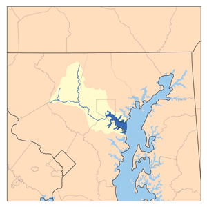
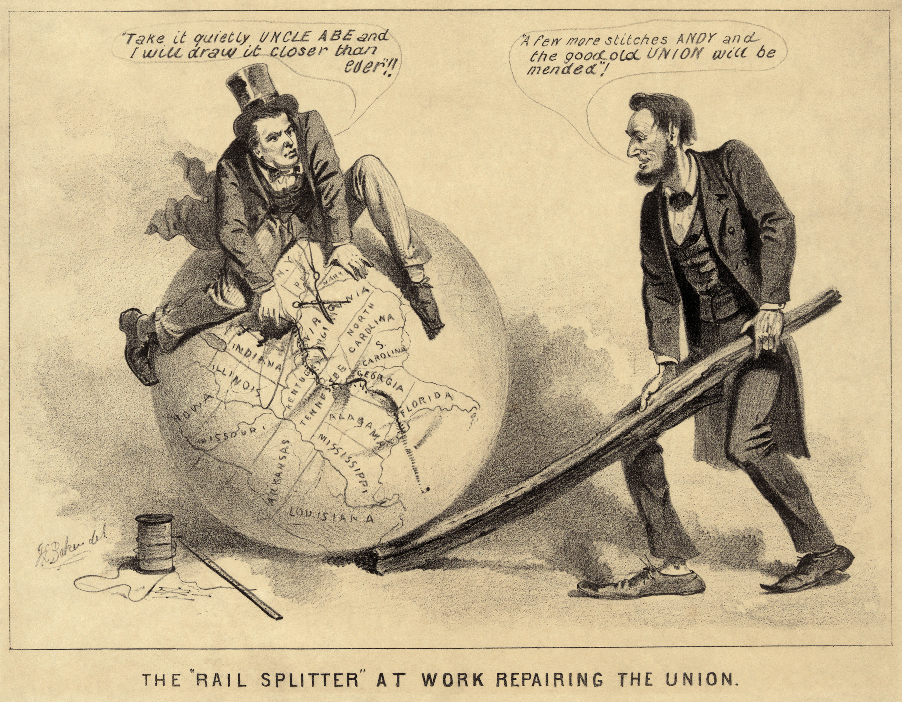
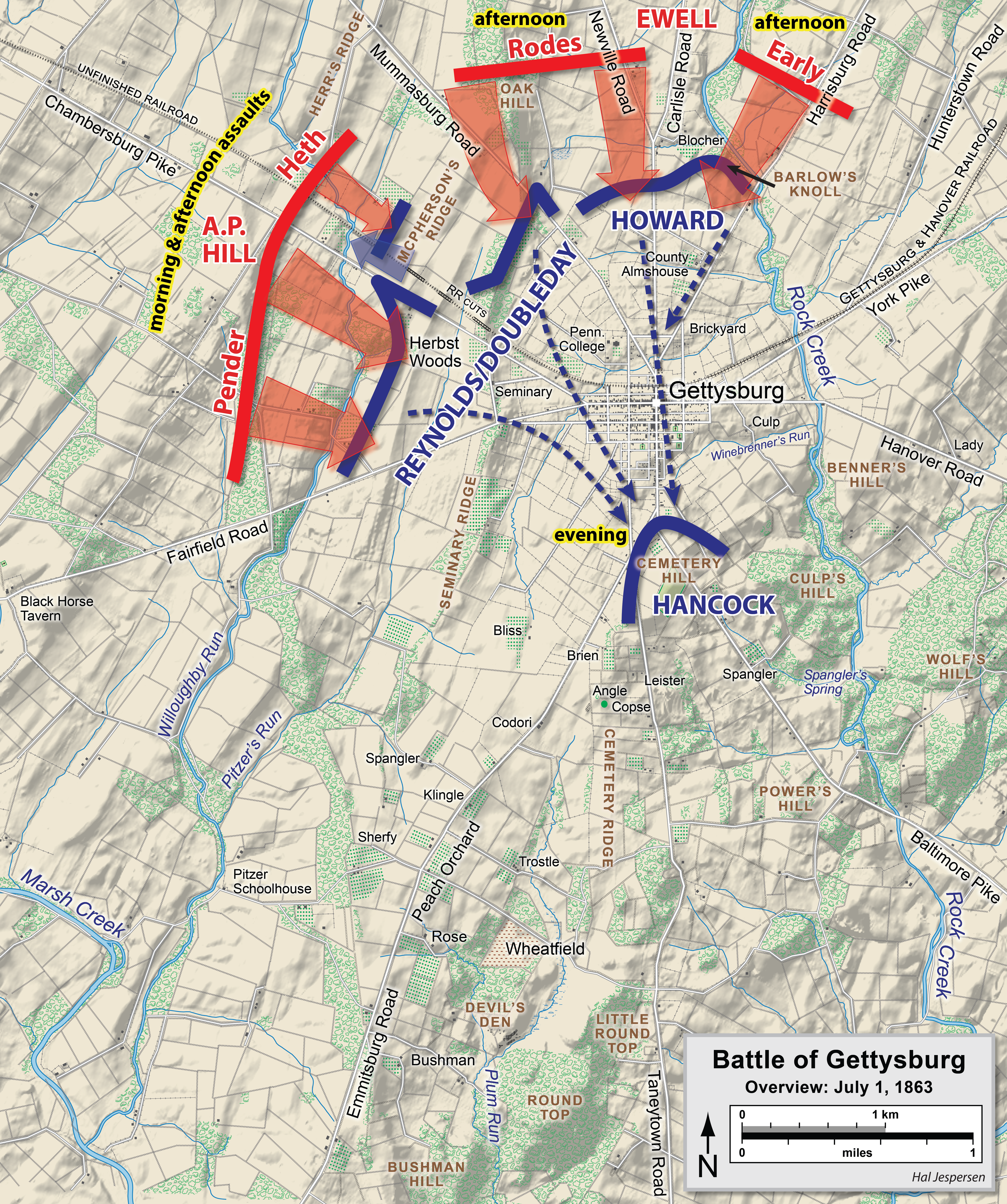
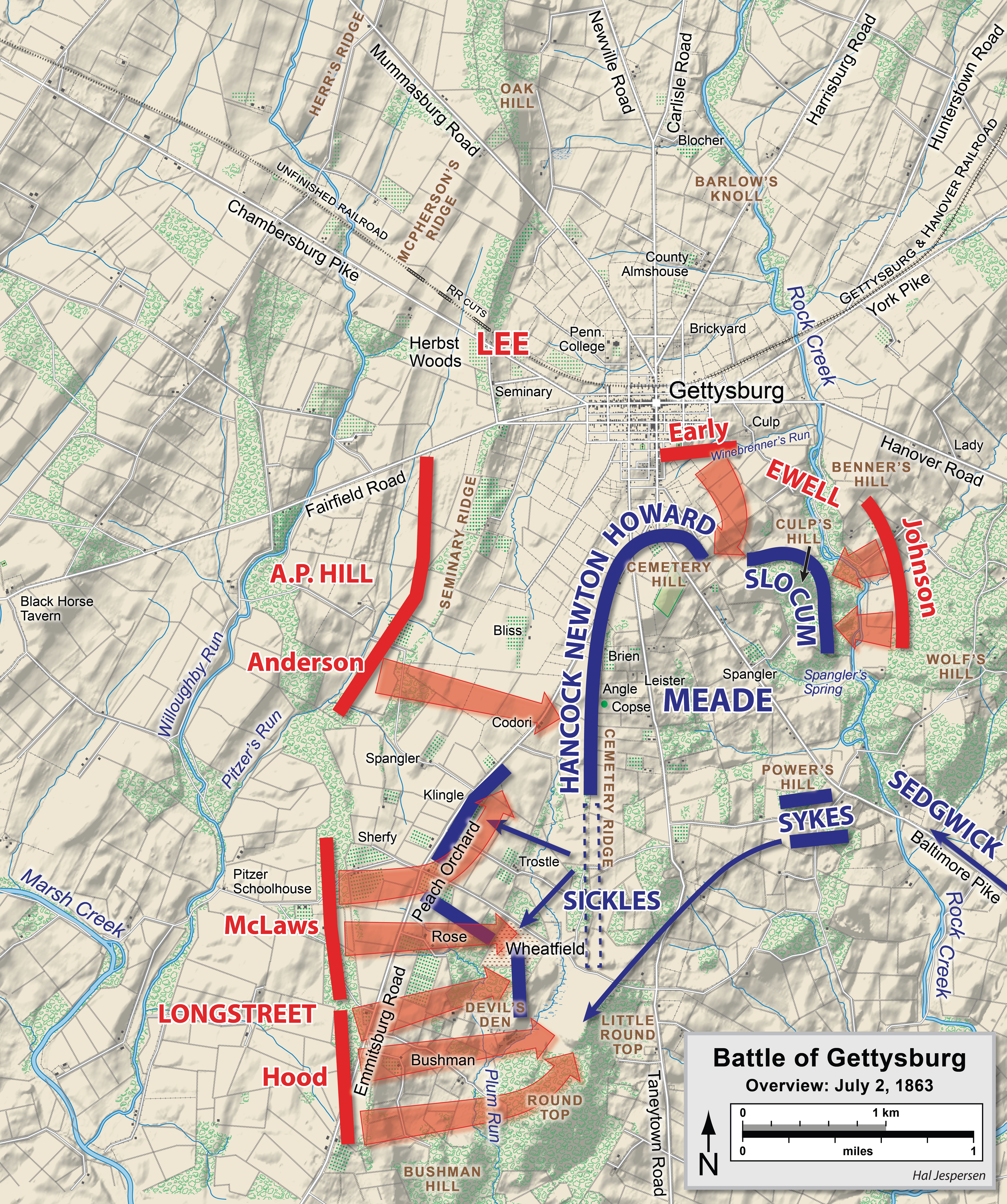
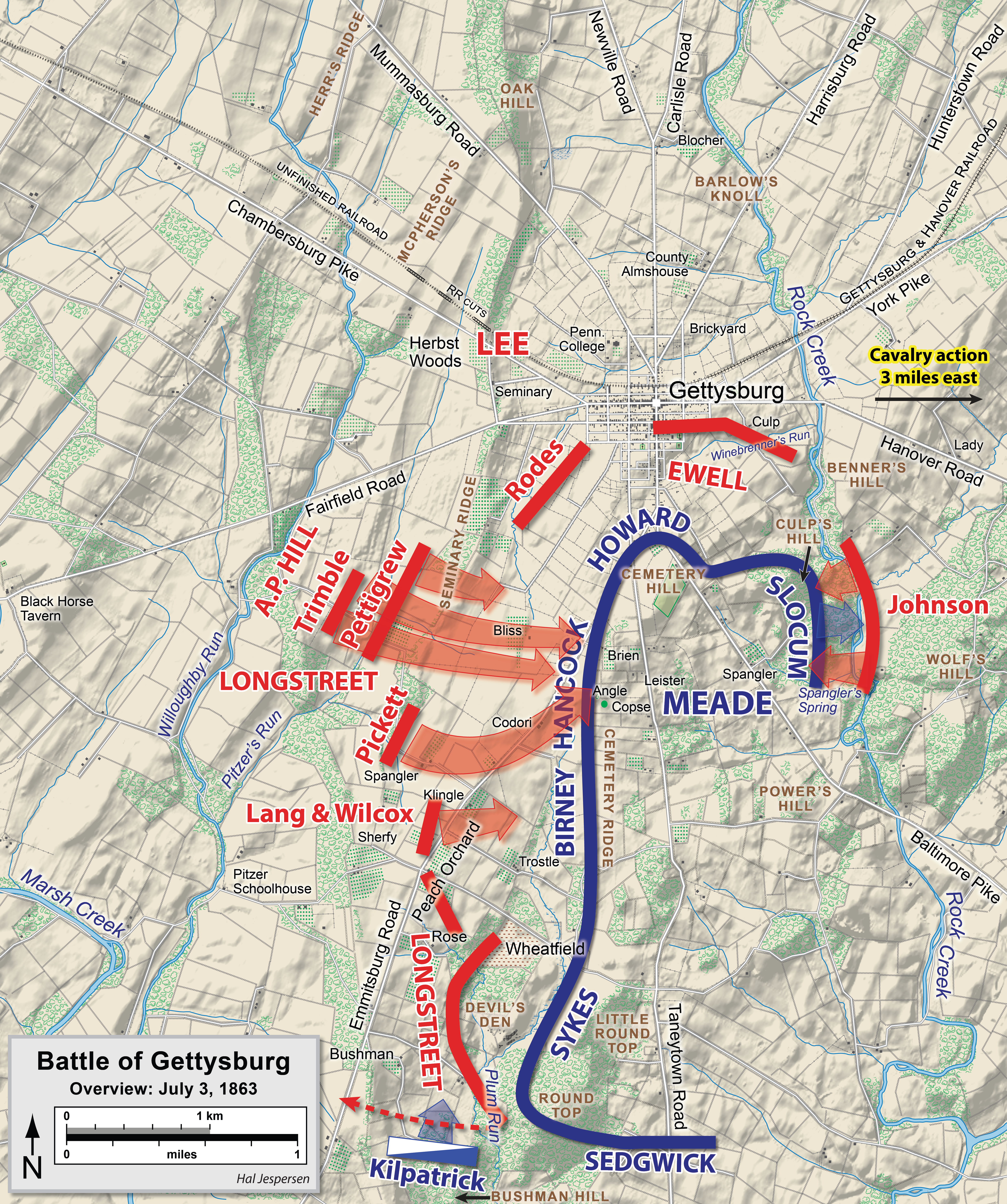
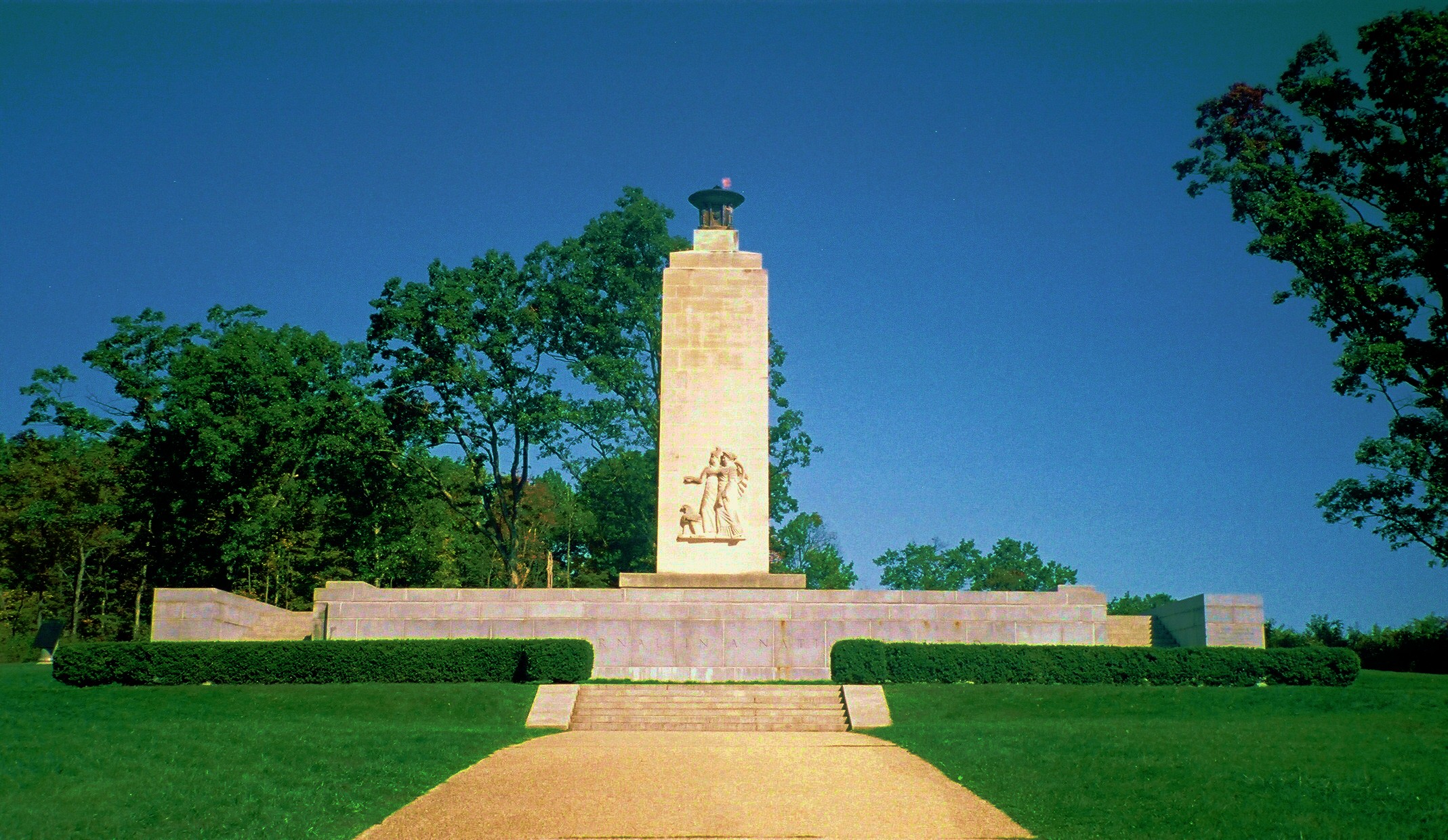
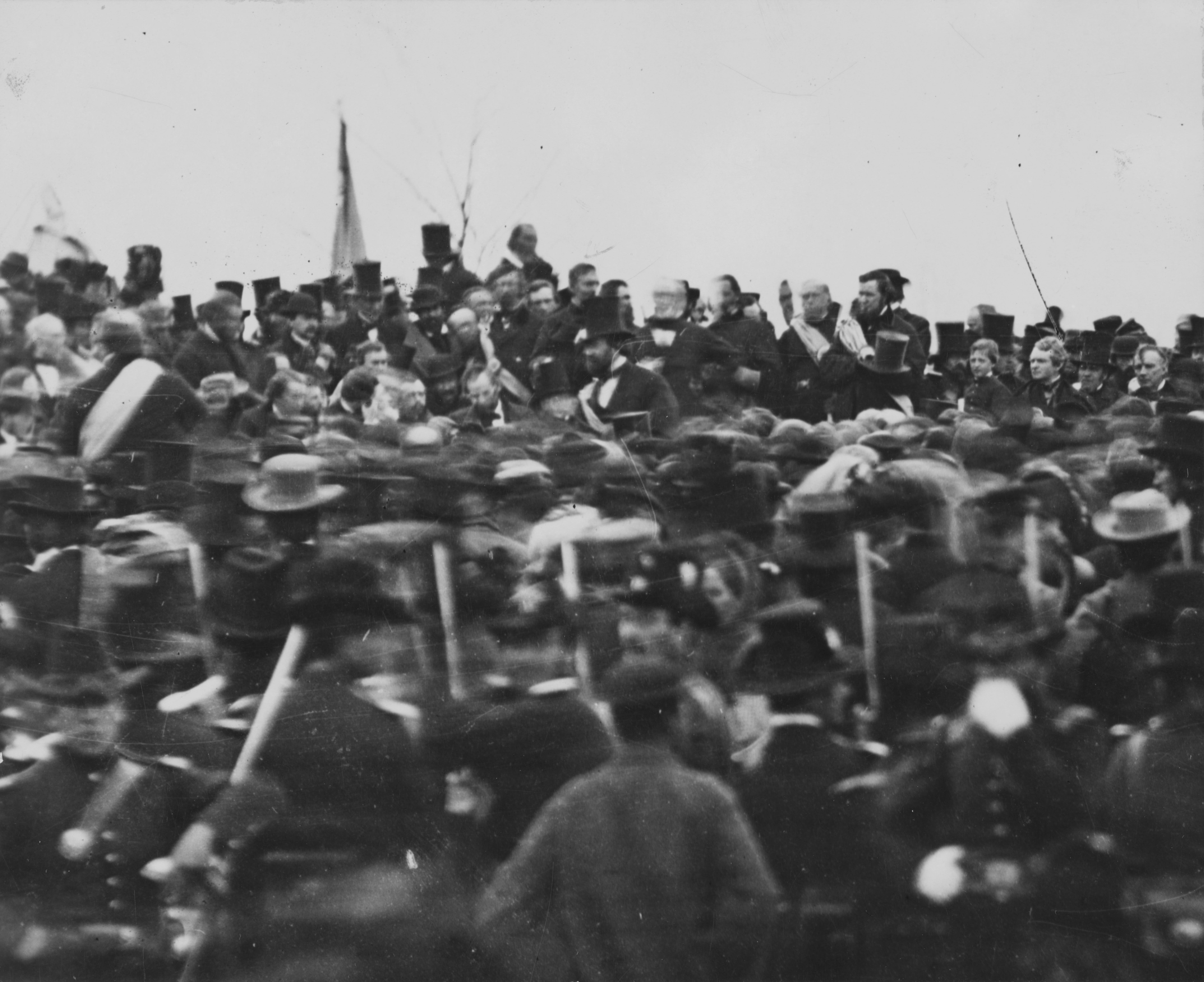