|
Reflections 2010
Series 28
December 31
New York Harbor II: The Ice Sheet & Primeval Waterways
| | Primeval Waterways in New York Harbor We are now ready to start. We first need to rewind the videotape from the present waterways and islands that we just reviewed to the past of many millennia ago. We’ll first talk a bit about before the Ice Sheet but we’ll primarily talk about right at its end. | | | | Pre-Ice Sheet the continental shelf was flooded (no ice north = high seas south). But there were no Outer Lands yet, so erase Staten Island, Brooklyn, Queens, and Long Island. Perhaps a dry Manhattan prong, with New Jersey, faced the sea directly. No waterways as we know them existed, since they were all glacially formed. Most notably, there were no Great Lakes yet, so no Hudson.
| | | | Much more interesting is the post-Ice Sheet landscape, right after it started its retreat north. The data I find says that the part of the Ice Sheet covering the bulk of the future New York City melted first, about 13-12 millennia ago. As we picture the landscape, the sheet remains in the northeast, over the Bronx and Connecticut. The only water in sight would then be Lake Connecticut (the future LI Sound) at the foot of the glacier, already formed 20-18 millennia ago. Reversing our formula (ice north = low seas south), the sea would be at the edge of the continental shelf, some 160 km (100 mi) to the south, so forget Raritan Bay and Lower New York Bay. The Outer Lands would have already appeared, brought by the receding glacier, leaving dry highlands along the continental shelf, which would later become Long Island, Queens, Brooklyn, and Staten Island. However they were all in one piece. The Narrows was a much later phenomenon (only 6 millennia ago), so Brooklyn and Staten Island were joined. Arthur Kill and those western waters came later, so Staten Island would have been joined to New Jersey. The East River came later (only 11 millennia ago), so the boroughs adjoining it today would then have been attached, and there was no Upper New York Bay yet, either. And Manhattan must have been connected to New Jersey, since the Hudson wasn’t here yet. As I say, there was only Lake Connecticut and the distant sea.
| | | | But where was the Hudson? The proglacial lakes that would eventually (10 millennia ago) become the Great Lakes as we know them were already emptying into the Proto-Hudson, or the Ur-Hudson. What happened to it south of the Hudson Valley? Where did its lower end go? Where was its mouth?
| | | | Well, the Hudson certainly did flow. Given the meltwater coming from the Great Lakes and gushing off the Ice Sheet, I’ve seen the Hudson described as a “turbulent” river, far different from its Sleeping Beauty status, and I certainly assume this applies to all other waterways in today’s harbor. Given its calm state today, it’s hard to visualize a churning Hudson, a whitewater river far too turbulent for whitewater rafting, as it carved its river bed and straight, parallel shorelines. As it churned away, the lower Hudson carved four--yes, four--different routes to reach the sea, while the East River had only one--its present one--before both became Sleeping Beauties.
| | | | Put another way, it is the Hudson itself (and to a lesser extent, the East River) that accounts for ALL the other waterways of New York Harbor. (!!!)
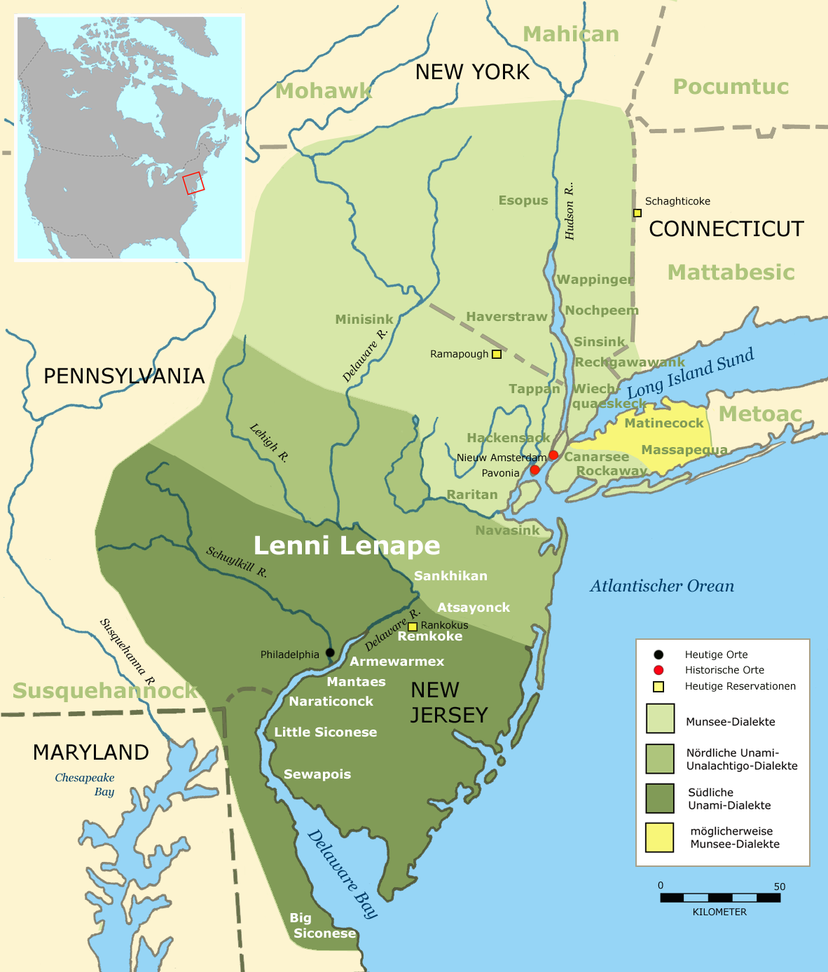
| | | | Hudson1 (Delaware) It was a shock to find out that the very first incarnation of the Lower Hudson, that is, south of the already discussed Hudson Valley, had nothing whatsoever to do with the present New York harbor area. It emptied instead into the Delaware River and Delaware Bay! I’ll call it the Hudson1-DEL. | | | | Reviewing this map of that watershed today, one sees that the Delaware starts in New York State, and there is a certain irony that a large part of New York City’s water supply travels by aqueduct from the state’s portion of this watershed, under the current Hudson, to NYC. The Delaware then forms the border between NY and Pennsylvania, then between PA and NJ, and finally between Delaware and NJ, where the river widens into Delaware Bay. Also note on this map a geographic quirk that has always interested me. The river forms a noticeable zig (>) where PA protrudes deeply into the wasp waist of NJ, just south of Trenton, NJ’s capital. Now, to see the route of the Hudson1-DEL better, let’s consult once again the Lenape map. | | | | Note where the Hudson is today. Instead of coming past Manhattan as it does now, the Hudson1-DEL swung WEST of the cliffs of the Palisades and Bergen Hill into the center of NJ. It then crossed NJ diagonally, past Newark to the Delaware River. It would seem possible that Newark Bay stems as a remnant of this route, but I found no information that that is definitively the case. Although I’d like to speculate that it is, we have to assume that it’s also possible that Newark Bay resulted from ocean flooding in some other manner.
| | | | My sources say that the Hudson1-DEL entered the Delaware near Trenton and then proceeded to Delaware Bay. I accept these facts fully as I found them, but the interpretation given was to me backwards. The Hudson1-DEL didn’t “enter” the Delaware. Saying that is looking at it with today’s eyes. The lower Delaware WAS at the time the lower Hudson1-DEL, and the upper Delaware was an early tributary of it. That’s what makes sense to me.
| | | | If the Hudson1-DEL joined the Delaware near Trenton, that would seem to be the explanation for the zig (>). The Hudson1-DEL flowed into the zig from the NE, and the Delaware entered it as a tributary from the NW, the combined river continuing out of the zig to the SW. Today only two elements are left (>) of this three-way connection. | | | | It is odd to think of the site of Philadelphia being on the Hudson1-DEL. Beyond that, with low sea levels, there wasn’t yet a Delaware Bay, and the river channel would have run along the bottom of today’s bay and then to the edge of the continental shelf. In this lower region, slopes would have been worn down on either side of the river from natural weathering, and when the sea eventually flooded, the widened sloped area became the trumpet-horn-shape of today’s Delaware Bay. (Incidentally, today the tides reach up the Delaware River to Trenton.) Once the Hudson1-DEL moved on elsewhere, the entire river became the Delaware, but the simple flow of the Delaware all by itself would never have carved a mouth of the size Delaware Bay, which has to be recognized as the first mouth of the Hudson1-DEL.
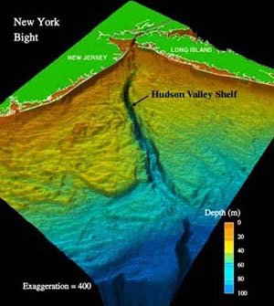
| | | | Hudson2 (Raritan) It may be comforting to know that all the later incarnations of the Hudson do actually involve the New York City area. The second incarnation involves the Raritan River, and I’ll designate it Hudson2-RAR. Continue referring to the Lenape map above. Hudson2-RAR, like Hudson1-DEL, continued past the WEST side of the Palisades and Bergen Hill and also COULD explain the existence of Newark Bay. But then, instead of continuing southwest, it sought a shorter route to the sea. Note on the map where the Raritan tribe was located. That’s the Raritan River of today, and Hudson2-RAR then turned sharply to the east at the present town of Blind Brook NJ and down the Raritan and into Raritan Bay. Again, that’s looking at it backwards. Phrased more sensibly, the second mouth of the Hudson, that is Hudson2-RAR, later became the Raritan River and Raritan Bay, which was formed in the same manner as Delaware Bay. There is no way that the small Raritan River could have formed a bay of that proportion. It was formed as the second mouth of the turbulent Hudson2-RAR. Refer again to this earlier map to see how Raritan Bay has the same flared trumpet-horn shape as Delaware Bay. It is also noteworthy that (1) New Jersey owes its peninsular form to these two successive mouths of the Hudson, one on each side, like bookends, and (2) the future New York Harbor began, not in the “center of things”, near the future Manhattan (which was still dry on all sides) but with Raritan Bay, at the southernmost extremity of today’s harbor, the part that’s ironically more often than not left off harbor maps. | | | | But we cannot leave the Hudson2-RAR until we finish describing its course beyond Raritan Bay. When we first discussed the undersea Hudson Canyon (2009/23), I correctly described the Canyon as having been formed by the Hudson, but naïvely assumed it was the contemporary Hudson that did so. Not so. I now see that the Hudson2-RAR was actually the first incarnation to begin carving the Hudson Canyon, which the two additional incarnations then continued before final inundation by the sea. The Hudson Canyon was formed 10 millennia ago when the sea level was about 120 m (400 ft) lower than today. It’s the deeply eroded riverbed beyond the current shoreline extending out into the Atlantic. It was carved by sediment coming down the river. It starts (today) as an undersea channel along the shallower continental shelf where it is 20-40 meters (yards) deep and several kilometers wide. At this point it’s known as the Hudson Shelf Valley. As the continental shelf then drops down the continental slope, the Hudson Canyon channel cuts through. This is the Hudson Canyon proper. At its end it reaches a depth of 3-4 kilometers as it joins the oceanic basin. The Hudson Canyon, whose walls rise some 1.2 km (0.75 mi) from the canyon floor, is comparable in size to the Grand Canyon (2007/14)--except, since it is now a submarine canyon, you can’t see it today.
| | | | This is the diagram we used in 2009/23 to illustrate the Hudson Canyon. It clearly shows the approximate right angle of the Jersey and LI shorelines forming and enclosing the New York Bight. Picture this area, not drowned as today, but unflooded by high sea levels in the period we are discussing. Do realize that, for purposes of illustration, the vertical drop is dramatized by being highly exaggerated. This section of the continental shelf where the Hudson2-RAR and two later incarnations flowed is called the Hudson Shelf, and the valley formed by the river’s turbulent, churning flow is the Hudson Shelf Valley (mismarked in the diagram), which then becomes the Hudson Canyon before the river plunges off the edge of the shelf into the low seas of the time.
| | | | I have two more good maps directly from the US Geodetic Survey. Both can be increased in size in your viewer. The first one of the Hudson Shelf Valley leading to the Hudson Canyon is more map-like than diagram-like and so has little or no vertical exaggeration. Just note how far the NYC area was from the ocean at that time. (Also note the Ronkonkoma Moraine on Long Island.)
| | | | But the other USGS map is more diagrammatic again. It’s a perspective view of this area looking NW, with only minimal vertical exaggeration. Beyond the Hudson Shelf Valley is the deep Hudson Canyon. But also note this: 1) NYC is far from the sea, with the mouth of the Hudson2-RAR being located at the edge of the continental shelf about 160 km (100 mi) east of its present site; 2) the Outer Lands shown here (Staten Island, Long Island), are merely higher land (moraines, outwash plains) than the surrounding shelf and are NOT yet islands; 3) the Outer Lands are shown as they are today, and you have to picture SI still attached to LI and to everything else, as there were no bays or rivers yet in New York harbor. The only water in the area would be the Hudson2-RAR leading to the sea, and Lake Connecticut (LI Sound). | | | | Hudson 3 (Arthur Kill) The river then continued moving east. As a matter of fact, from this point on, the Hudson Canyon remained as the southern extremity of any incarnation. The only variation was how the river, coming down from upstate New York, went through the harbor region before heading for the Hudson Canyon. After the Raritan, it carved its way down Arthur Kill, which I’ll signify as Hudson3-ARTH. Look at it again on the earlier map.
| | | | Apparently this route was the first time that the river shifted from behind the Palisades and Bergen Hill on Bergen Neck (west side) to in front of them (east side), where it is now, adjacent to Manhattan. Beyond that, the research says that it cut its way down the west side of Staten Island, separating it from New Jersey (it was still attached to Brooklyn). Nothing has told me how the connection between them was made, so we need a little conjecture here. The Narrows didn’t yet exist, and probably Upper NY Bay was minimal in size. My presumption has to be that the river reached the barrier of the Staten Island moraines, and turned west down Kill Van Kull to reach Arthur Kill. This incarnation then, did not carve its own bay as an estuary, but, like its predecessor, emptied into the area that would later become Raritan Bay, and on to Hudson Canyon. The conjecture also has to be that, despite their different names today, Kill Van Kull and Arthur Kill are the same waterway. I also presume that this route passes Newark Bay is just a coincidence. Picture the turbulent, roiling Hudson3-ARTH carving its way to the sea, but later, when it moved on, the Kills would be just an abandoned, flooded, former river channel.
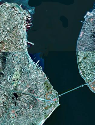
| | | | The size of the channel through the Kills is large, which is what suggests it was, for a time, the primary drainage from the region. However, it could not have been a primary drainage for long because the river did not have enough time to carve a broad flood plain on its banks. By comparison, the valley of the Raritan River just barely to the south is much broader. This is an indication that the Raritan had been perhaps the major drainage channel for a long period. | | | | Hudson4 (Narrows) It becomes obvious that, since water tends to seek the shortest route to the sea, each incarnation of the Hudson moving east involved its taking a shortcut. In addition, during times of rapid melting river flow must have been very great. Breakouts caused by ice-dammed rivers frequently breached ice and moraine blockages, causing massive floods. And so, finally, after earlier cutting the Outer lands (Staten Island) away from the NJ mainland, the Hudson abandoned the Kills and, with a buildup of water in Upper New York Bay, burst its way through the moraine at a point further east and therefore formed the Narrows, which I’ll designate as Hudson4-NAR. This is the easternmost route of all it has taken. Beyond the Narrows it then formed what would become, when later flooded, Lower New York Bay on the way to Hudson Canyon. Notice in this satellite view of the Narrows how river-like this short stretch is between bays. The Verrazano-Narrows Bridge connects SI and Brooklyn. | | | | Thus, Raritan Bay and Lower New York Bay are twin bays resulting from different incarnations of the Hudson. With the breaking through at the Narrows, Staten Island for the first time was an island in its own right, no longer connected to Brooklyn and the rest of LI. Actually, Staten Island is totally a child of the Hudson, which is responsible, during successive incarnations, for all the waterways surrounding it, in order, Raritan Bay, the Kills, and the Narrows.
| | | | The breaking through of the Narrows is one of the most recent developments, occurring a mere 6 millennia ago. While almost all other developments we’ve discussed were vastly prehistoric, 6 millennia ago is just 4,000 years before our present calendar. At that point, Middle Eastern civilizations were already developing.
| | | | Hudson5 (Mohawk) We are now up to more recent times. There’s no turbulence of flow any more, and no flow at all beyond tidal currents. All the waterways we’ve discussed are now just former river channels flooded with seawater. But how shall we classify what we have today?
| | | | What we call the Hudson today is truncated. It’s considered to terminate today, not in Hudson Canyon, but merely at the southern tip of Manhattan, just outside my window. Between that and the Bight the Hudson’s only influence is to continue to delineate an east-west division in the metropolitan area. But what about north of the southern tip of Manhattan? Let’s look again at a map of the Hudson watershed and then return to our dual reality (2010/25).
| | | | For everyday use, we can ascribe to the feel-good fairy tale that what we now have is a Hudson5, the quiet Hudson, that flows from Mount Marcy to Lower Manhattan. It’s a charming emotional reality, like watching “the sun go down” and seeing a beautiful “sunset”. We’ll even continue calling it the Hudson River, although I tend to be noncommittal and just call it the Hudson.
| | | | But then we also lean on the scientific reality, where we acknowledge that in actuality, the sun stands still and the earth is spinning us away from it as we watch a “sunset”. We acknowledge then here that the Hudson is truncated much more than just at Lower Manhattan. Tidal currents and saline water reach all the way to the Albany-Troy area, just below the confluence of the Mohawk. Therefore, the fifth incarnation of the Hudson does exist, from Mount Marcy a short distance to just beyond the Mohawk, as the Hudson5-MOH. From the Mohawk we merely have the Hudson Estuary, within the Hudson Fjord, commonly called the Hudson Valley.
| | | | East River We have seen that all the waterways in the harbor west of the Hudson were caused by succeeding manifestations of the Hudson. The East River story is simpler. Yes, it once was a real river, but one that didn’t wander, and always kept to the same bed, before coming the tidal strait it is today. But even as a tidal strait, we can still call it the East River (you can’t shorten it to (*the East). And essentially, everything in the harbor east of the Hudson is East River-related. Let’s use this map to study the East River.
| | | | The East River was formed 11 millennia ago. It’s essential to recognize the distinct change in the shape between its lower and upper parts, each part showing evidence of different glacial activity. The Upper East River, between the Bronx and Queens, runs roughly E-W, and was perpendicular to the N-S glacial motion. This stretch is very lake-like, having run along the length of the melting glacier. It remains wide and meandering, with deep bays scoured by the glacial activity. The Lower East River runs roughly N-S. It’s much more river-like in nature, being narrow, with straight, parallel banks. The research tells me that this section was the actual river that drained the glacier into the Hudson at Upper New York Bay.
| | | | Think about what made Long Island an island. The south shore developed last, with the ocean flooding of the continental shelf. The north shore would have developed first, since Lake Connecticut formed early on. That means that the development of the East River is responsible for separating Long Island from the Manhattan Prong, preparing Long Island to be an island once the sea flooding came.
| | | | The most confounding waterway in the harbor to me is the Harlem River, separating Manhattan from the Bronx (note on the map above the northern tip of Manhattan the tiny piece of Manhattan today on the Bronx side, forming the second--but tiny--land border between boroughs, other than Brooklyn-Queens). Nowhere does the research explain the origin of this river/tidal strait. We can only conjecture. It seems unlikely that a branch broke off the Hudson to connect with the East River. More probable to my way of thinking is that the overflow of the Upper East River that didn’t make it down the Lower East River instead flowed north (??) to reach the Hudson at an earlier point.
| | | | But the research also falters when it comes to proving my big suspicion. What’s the historic relationship between the East River and LI Sound (ex-Lake Connecticut). Doesn’t the Upper East River seem to have a closer resemblance to the Sound than to the Lower East River? I find no statement that says so, so we’ll have to use some conjecture. Let’s look again at the USGS map of glacial Lake Connecticut. The current state of Connecticut is shown from the north, where the glacial meltwater came from. There’s no indication that the moraine on LI ever failed, causing a southward leak in the lake. The eastern end of the moraine held as well until it finally did succumb to the sea during the flooding, when Lake Connecticut went from freshwater to seawater (seawater continued up the CT River through CT and Massachusetts). But long before that, where did the outflow go? The USGS map clearly says that all waters marked in blue are part of Lake Connecticut, and at the SW corner, you can see a narrow branch of the lake. I suspect that’s what we today call the Upper East River, and the lake-like strip catching glacial meltwater is in reality this slender branch of Lake Connecticut. I am substantially satisfied then, that in actuality, “Upper East River” is a misnomer, it’s really LI Sound that reaches all the way in to Manhattan, at which point it becomes the actual East River, and not the “Lower” East River. | | | | There is more food for thought. Look again at this map. Consider the point in time before the Narrows was formed, when the turbulent Hudson3-ARTH passed Manhattan and then turned down the Kills. More conjecture: Wouldn’t the East River have been just as turbulent? Wouldn’t the two churning rivers meeting off the tip of Manhattan have caused the Upper Bay to form? Wouldn’t East River waters (from Lake Connecticut) ALSO have churned their way down the Kills?
| | | | And even more conjecture, a step further: While the Hudson2-RAR was coming down the Raritan, wasn’t the East River already in action? Could it possibly be that the route down the Kills was an extension of the East River in the first place? Look again on the map at the diagonal line across the region formed by the East River and the Kills. Maybe the East River, coming down Arthur Kill, first met the Hudson, coming down the Raritan, at Raritan Bay? Maybe when the Hudson moved over to become Hudson3-ARTH it went down Arthur Kill because the East River was already doing so?
| | | | Finally, when water flow cut its way through the Narrows, could it not have been caused by BOTH the flow of the East River out of Lake Connecticut along with the Hudson?
| | | | This conjecture at the end is all just wild guessing. Don’t believe a word of it, but it really is food for thought.
| | | |
| |
|
|
|

