|
Reflections 2010
Series 27
December 31
New York Harbor I: Today's Waterways and Islands
| | Do remember that the whole purpose of this Ice Sheet series was to get to the topic of New York harbor and the development of its waterways, but once I got started I found I had so much more to research and learn. How can you leave out the fact that the Great Lakes was the original source of the Hudson, including the affect of the catastrophic collapse of the upper part of Lake Iroquois (today Lake Ontario)? How can you leave out the story of the Hudson Valley, including Glacial Lake Albany reaching down almost to the New York City area? And how can you leave out the story of the Outer Lands, particularly given that Staten Island and Brooklyn enclose New York harbor to the south? | | | | But as we approach discussing New York harbor, we must finally acknowledge the 900-pound gorilla in the middle of the living room: What happened to the Hudson at the lower end of the Hudson Valley? Once we ascertain that--and it’s a fabulous story--we can add the second factor, just how the East River affected the scene.
| | | | In 2008/3 we discussed what happens at the lower end of the Mississippi, and compared it with what happened at the lower end of the Rhine, a rather different story. But how the myriad waterways of New York harbor came about, creating so many islands in between them, is a unique story unto itself.
| | | | But non-New Yorkers will need a primer here, complimenting what we already discussed in 2009/23. Actually, so will New Yorkers, since the complex of waterways and islands confounds many of those as well in this large metropolitan area. I question how many Long Islanders in the east know where Arthur Kill is in the west, or how many New Jerseyans in the west know where City Island is in the east. And I remember at least one gross, blatant error occurring on a major police television show with international pretensions, famously filmed on the streets of New York with a solidly New York cast. Upper Manhattan (Harlem) is separated from the Bronx by the Harlem River. Beyond that, flowing down the center of the Bronx is the very local Bronx River, which flows through Bronx Park next to the Bronx River Parkway. Yet it was a major point on one program that the jurisdiction of the Manhattan DA’s office didn’t extend into the Bronx, only “to the Bronx River”. Humbug. Everyone needs to look at a map or two before we proceed.
| | | | New York Harbor Today Although the harbor in most minds refers simply to New York City, it is in all fairness officially the Port of New York-New Jersey, referring instead not to the city but to the two states encompassing it. Also rather well-known is the governing body of the harbor, the Port Authority of NY-NJ. It’s particularly well known as being the owner of the land under the buildings of the World Trade Center, as well as for the principal bus terminal in Manhattan, the Port Authority Bus Terminal. (People always shorten the name and talk about getting a bus at the “Port Authority”, as though that maritime name automatically implies buses, or that it implies the offices of the organization, which it does not.) | | | | New York Harbor Geography 101 Let’s start slowly by looking at a simple, but very clear, map denoting NYC’s five boroughs and waterways between them. A more comprehensive map will follow. | | | | MANHATTAN PRONG (UPPER EAST HUDSON) The slender shape of Manhattan is easy to spot. Across the narrow Harlem River is the Bronx, the only part of NYC on the North American mainland, followed to the north by suburban Westchester County, of which the Bronx was a part up to consolidation of Greater New York in 1898. (The previously mentioned Bronx River, not shown here, descends N-S down the center of Westchester and the Bronx.) These three counties, continuing both upstate up the east bank of the Hudson and also continuing NE to Connecticut and New England, comprise the granite-based Manhattan Prong, which by far predates the Outer Lands to the south.
| | | | To the east of Manhattan is the East River (secondary to the Hudson), whose lower portion is river-like, but whose upper portion along the Bronx is lake-like. (This will be significant later.) It then continues to Long Island Sound.
| | | | BROOKLYN, QUEENS, LONG ISLAND (LOWER EAST HUDSON) To the east of the line of the East River/LI Sound is Brooklyn (Kings County) and Queens (Queens County), both at the western end of Long Island, which continues with Nassau County, which was part of Queens up until the 1898 consolidation, and then Suffolk County. Note that the land border between Brooklyn and Queens is the only major land border between boroughs. (There is a tiny land border between the Bronx and the northernmost tip of Manhattan where a small piece of Manhattan ended up on the opposite side of the Harlem River due to construction straightening the river bed.)
| | | | [Before proceeding we should mention some other islands, merely as trivia. In a recent sailing video that included Long Island waters we spoke of City Island, which can be seen just off the East Bronx, and Hart Island just beyond. Of greater historical importance are Governor’s Island at the lower end of the East River, and, across on the New Jersey side, Liberty Island (Statue of Liberty) and above that, Ellis Island (Immigration Station). Governor’s Island was the first stopping point in 1624 of Dutch settlers on the way to New Amsterdam a short distance away at the bottom of Manhattan. The Dutch called it Noten Eylandt [modern spelling Eiland]), meaning “Nut Island”. The name in Dutch-English pidgin later became Nutten Island before the renaming of the island to Governor’s Island in 1784. (A pidgin [the bird is spelled pigeon] is a simplified, intermediate form of language that develops to ease everyday communication when two languages overlap. The word “pidgin” is itself a pidgin word deriving from a Chinese pronunciation of the English word “busin(ess)”. A pidgin is also called a contact language.] | | | | NEW JERSEY, STATEN ISLAND (WEST HUDSON) The major divider of the region is the Hudson, which passes to the west of Manhattan. Although today it officially ends at the lower tip of Manhattan, in a practical sense its former course can be considered to divide the region, that is, continuing through Upper New York Bay, through the Narrows separating Staten Island and Brooklyn, into Lower New York Bay, and bending out to sea past Coney Island and the Rockaway Peninsula.
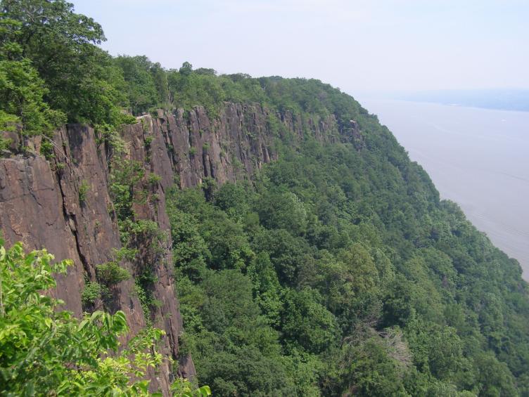
| | | | At and beyond the upper edge of the map, the west bank of the Hudson starting south of Nyack NY, then continuing into New Jersey consists of the cliffs known as the Palisades. They essentially form the west side of the Hudson fjord, as seen more clearly in this view to the west from Manhattan that includes the George Washington Bridge. Toward their southern end, the Palisades veer slightly inland along the huge NJ peninsula opposite Manhattan called Bergen Neck (check above map again), where the Palisades are known instead as Bergen Hill. The Palisades and Bergen Hill are significant in the development of the Hudson.
| | | | To the east of Bergen Neck is Upper New York Bay, to its south, separating it from Staten Island, is Kill Van Kull, which then continues around Staten Island to the west under the name of Arthur Kill. To the west of Bergen Neck is Newark Bay, fed by the Passaic and Hackensack Rivers, which, along with the Bronx River and Raritan River (below) are the only actual rivers in all the waterways we’re discussing (the big ones, whether called “river” or by the Dutch term “kill” are all tidal straits). Note in this detail of their watersheds how the Palisades and Bergen Hill (on Bergen Neck) keep their water from meeting the Hudson directly.
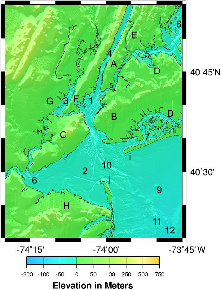
| | | | Maps of this region are notably lax in showing the entire harbor, usually just showing the five boroughs, so we need this map (Map by Rmo13) that includes southern portions. Actually, this map has the advantage of showing the granite ridges coming down the Manhattan Prong, the moraine separating hilly, upper Brooklyn and Queens from the flat outwash plain leading to Jamaica Bay, and rather well, the Palisades becoming Bergen Hill in Bergen Neck. It also shows the underwater channel (#10), formerly the bed of the Hudson and still used by shipping, through the Narrows and out to sea.
| | | | But the main purpose of this map is to show that last river, the Raritan River, emerging from New Jersey right at Arthur Kill at the bottom of Staten Island. The Raritan River then flows into the broad Raritan Bay (# 6), which in turn abuts Lower New York Bay (# 2). The “barrier peninsulas” (2010/26) of Sandy Hook (j) and the Rockaway Peninsula (i) frame the entrance to the harbor. # 12 is the drowned Hudson Shelf Valley leading to the Hudson Canyon (2009/23 and below).
| | | | Finally, the Hudson Canyon is located in the New York Bight (# 9). A bight (sounds like “bite”) refers to both a bend or sharp angle in a coastline as well as the shallow bay encompassed by it. For instance, the large curve in the south-central coastline of Australia is the Great Australian Bight; the near right angle of the North Sea along the German, Dutch, and Danish coasts is the German Bight (GE: Deutsche Bucht; DU: Duitse Bocht; DA: Tyske Bugt); and the near right angle formed by the coasts of New Jersey (ending in Sandy Hook) and Long Island (ending in the Rockaway Peninsula) encloses the New York Bight. Put another way, sea bathers on the Jersey Shore or the Long Island Beaches are bathing in the New York Bight of the Atlantic Ocean. The relatively shallow New York Bight includes both the Hudson Shelf Valley and the Hudson Canyon. Unfortunately, the arrow shape of the New York Bight can facilitate storm surges directly into Lower New York Bay, putting the region into a high-danger zone for tropical storm-generated ocean surges, despite its northern latitude. | | | | We mentioned before that there are only about four real rivers surrounding New York Harbor. Everything else has been drowned out, and is merely tidal. That obviously includes everything called a bay or a sound, but it’s essential to understand that that also includes anything called a river (or kill). There are no river currents. There is just the inflow and outflow of the tides, and that includes everything up the Hudson Fjord (“Hudson River”) up to about the Mohawk River. The sea has invaded the remaining channels of the former rivers. Mind you, they all had once flowed genuinely, but today they are all Sleeping Beauties. Picture a sleeping person’s chest rising and falling and transfer that image to the waterways of New York harbor rising and falling with the tides, plus of course tidal movement upstream and downstream on the Hudson. Given the drowning of all the major waterways, I would assume that even the Raritan, Passaic, Hackensack, and Bronx rivers, although genuine, flowing rivers, still have a certain amount of saline tidal inflow at their mouths, such is the extent of the drowning of the entire region by the sea.
| | | |
| |
|
|
|

