|
Reflections 2025
Series 8
November 9
An Unorthodox View of NYC's Five Boroughs via Maps I
| | In discussing Academia, so far specifically Brooklyn Tech, we dealt quite a bit with long distance travel by subway to schools within NYC. As a matter of fact, right after the posting came out I heard from a friend now in Florida, Norm Foy, who detailed how the posting got him thinking of taking a long subway ride from the West Bronx down to the old, original building of Stuyvesant HS on East 15th Street. I hadn't realized I knew someone who went to Stuy, and to the old building at that. I had only been to that building as a 13-year-old to take the entrance exam.
https://maps-nyc.com/img/0/mta-subway-map.jpg
Here's our NYC subway map from the last posting. Norm and I discussed how he would have taken the 4 train (green) from Fordham Road down to 14th Street/Union Square, and then the L train (gray) two stops toward Queens to 1st Avenue for a quick walk to (Old) Stuy on 15th. Not bad for a longer ride.
https://ccnmtl-writlarge-static-prod.s3.amazonaws.com/uploads/2023/04/28/StuyvesantSchool.png
I found this picture online of (Old) Stuy and sent it to Norm. He wrote: My main memory of the front is getting there before they opened the doors and standing in the rain and snow. There was a set time for the doors to open and they did not seem to ever deviate from that time--no matter what the weather! The discussion did cause me to remember that, in rain or snow, we would frequently stay in the [subway] station near Stuyvesant until the last possible moment OR until the subway workers/police kicked us out into the bad weather.
I appreciate additional comments such as this as to the adventures involved in subway travel to high school.
| | | | Five Boroughs But to the point: we talked about interborough travel to high school, and it struck me that we needed to say more about all these boroughs. Why are there five (NY5)? When did that happen? How did it happen? There's a lot more to discuss, and we can and should do it right now. Maps will be a huge help. Doing so involves reviewing the numerous waterways of the region, as well as how region was settled by the Dutch, then British. It will be an unorthodox assessment, dividing the huge region in a West Bay Area and an East Bay Area. Enjoy the ride.
The New York metropolitan area, called the "Tri-State Area", is the largest metropolitan area in the world, and in 2020 was the most populous in the US, with 20.1 million residents, or slightly over 6% of the nation's total population (Map by Tatiraju.rishabh). It includes suburban and exurban New York counties to the east and to the north (including three in SE Connecticut), and to the west to New Jersey, also swinging around to the south.
| | | | | | This is the only time we'll see Westchester county, so let me point out some places there. Beverly and I lived in Wakefield in the North Bronx after we got married, then moved to North White Plains, then built a house in Purchase NY, both of which are located in the narrow waist of Westchester, where Fairfield County (CT) makes an indentation. Where Terry and I worked at John Jay HS is above that and east, where Westchester makes a deep indentation into Fairfield. |
| | | | Again back to the point: I find it interesting that this map includes, along with NYC's five boroughs, Hudson County in NJ (#6), sometimes called the "sixth borough". Let's use that as a starting point for a major argument we'll be making. Note how both Hudson County NJ and Richmond County (Staten Island) NY lie off to the west of the large bay area in this region, while four NY counties and boroughs lie clustered together to the east. (For later, note Essex and Union counties.) In our unorthodox discussion here, we'll be making a major issue of the remoteness of Staten Island from the other four boroughs—which I'd like to refer to as the "Home Boroughs"-- and how this affects attitudes in the region. More in a moment. | | | | | | Side comment on SI. To this day, the Netherlands parliament is called the Staten Generaal ("General States"). Dutch settlers named the island Staaten Eylandt after their parliament, later anglicized to Staten Island. At the time, their country was called the Republic of the Seven United Netherlands, which accounts for the fact that the name "Netherlands" to this day is still a plural, as well as "Staten/States". |
| | | | I'd also suggest taking another look at the subway map. Granted, SI doesn't have subways (they got as far as building a short tunnel in 1923 to extend the R train in Brooklyn, but it was abandoned due to lack of funding. What is shown in SI is considered a railroad, not a subway.) Nevertheless, on this map, four boroughs are shown full size, while SI is shrunken to a little nothing in the corner. Manhattan is the smallest borough in area, and SI is 2 ½ times larger. Also, remote SI is much further from the others than shown—the ferry ride is much longer. But people who rely on the often-seen subway map (and similar) to get a mental image of NY5 will have a very poor understanding of SI.
https://imgcap.capturetheatlas.com/wp-content/uploads/2022/12/boroughs-of-new-york-city-map.jpg
Hold onto this view of the "five boroughs of NYC". Hudson County is rarely shown with them in maps, since it's in NJ and is not part of NYC (NY5). Hudson County is primarily the peninsula in white north of Staten Island and west of Manhattan, reaching up to Manhattan's Upper West Side.
| | | | | | It's worth noting that, of the three principal airports serving the metropolitan area, while Kennedy and LaGuardia both lie to the east (in Queens), Newark lies to the west, south of both Hudson County and Newark, in both Essex and Union counties. This is just one more illustration of the West-East dichotomy we'll be talking about. |
| | | | The NYC boroughs, ranked by land area, are easy to remember by two rows. In the first row from east to west are Queens, Brooklyn, Staten Island; in the second row are the Bronx, and Manhattan. Hudson County would fit in the middle, being just 9% larger than the Bronx. Below is a better look at it.
https://images.mapsofworld.com/usa/states/new-jersey/hudson-county-map.jpg
While we said that Hudson County lies primarily on the peninsula east of the Hackensack River and Newark Bay, there is also a protrusion to the west. While I have lived (in sequence) in Brooklyn, Queens, the Bronx, and Manhattan, I've also spent nights in Hudson County using those free one-night certificates Marriott gives out: in Weehawken (south of West NY) in 2021, in Jersey City/Newport (south of Hoboken) in 2023, and inland, in Harrison (for Newark) in 2020. But despite numerous visits, I have, unfortunately, never been able to work it out to spend a night in Staten Island.
The NYC boroughs ranked by population (in millions) are: Brooklyn 2.6, Queens 2.3, Manhattan 1.6, The Bronx 1.4, and Staten Island 0.5. Hudson County has 0.7. Both HC and SI are well under a million, yet SI is more remote with less population.
We'll shortly see how confusing the name "New York", can be, so to start with, let's separate NYC from New York State (NYS). These don't usually get confused, but there's one striking exception. In 1977, NYS arranged for a slogan and logo to promote tourism in the state. It's the famous I love New York slogan, stylized as I ❤ NY, and sometimes even read as I "heart" NY. This is the official state slogan of the State of New York. The logo was designed in the back of a taxi and was drawn with red crayon on scrap paper. The original drawing is held in the Museum of Modern Art in Manhattan (!). I'm totally convinced that, since NYC is much better known worldwide than NYS, the general assumption is that the slogan refers simply to NYC, and I suspect that's even the case with locals.
RANKING But let's move down from the state level to the metropolitan level. It would seem that the five boroughs happily mesh together as one big happy family, which we've been calling NY5. Do you believe that? First let's look at a regularly accepted ranking, involving the expression "outer boroughs". This actually ranks them not as 5 but as 1+4, setting Manhattan aside as "king"—let's call it NYm—lording it over the other four. Let's face it: international and national visitors coming to "New York" really mean they're visiting just NYm. I've been glad to see occasional tours from Manhattan to Downtown Brooklyn, but most visitors find enough to do in NYm to keep them busy, even on repeat visits.
I have to be horribly politically INcorrect here—no politician would ever admit to this openly—but the ranking is in reality more stratified than 1+4. Actually, it's 1+3+1. NYm is on top, and remote Staten Island is at the bottom of the totem pole. The New York Times recently referred to it as the "forgotten borough". While many locals make jokes about New Jersey, they also make jokes about the remoteness of Staten Island (SI). In fact, SI is the Cinderella of the boroughs. As Rodney Dangerfield joked about himself, "I don't get no respect". In fact, neither does SI.
I've traveled extensively thru all the boroughs, and that includes SI. I've dined memorably in some nice restaurants in SI, tho it's the only borough I never lived in or, as mentioned, even spent a night in. Still, I have wonderful memories of sitting on the lawn of the Alice Austen House Museum in the Rosebank neighborhood, looking out onto the Narrows and up to the Verrazzano Narrows Bridge to the right. I remember the Historic Richmond Town Restoration, and the Conference House in Tottenville, where a conference was held in an attempt to avoid the Revolutionary War. Yet it should be noted that Tottenville is so remote that it's the southernmost neighborhood in both NYS and NYC, and the westernmost neighborhood of NYC (Map by Decumanus).
COUNTIES We've been talking about boroughs, but NYm's five boroughs are also counties, and have been so for a long time. It was on 1 November 1683 that the Colonial Assembly established the first counties in NYS. Among them were: New York (Manhattan island), Kings (Brooklyn), Queens (much larger than today), and Richmond (SI). Does something seem to be missing? Did you expect a fifth one? How do you explain that mystery? Read on.
Of the suburban counties nearest the five boroughs, on that same date they also established Westchester to the north--but MUCH closer than you might think—and Suffolk on eastern LI. Again, do you feel a suburban county on Long Island is missing? How can we explain that? Again, read on.
WATERWAYS The unconventional division we're going to make of the NY5 area all depends on the geography of the area, specifically the waterways. We tend to pay attention to the land areas, but might forget they're (mostly) subdivided by water.
https://maps-nyc.com/img/1200/new-york-city-rivers-map.jpg
To make sure we're all on the same page about the names, the above shows the NY5 "rivers". I put that in quotes because most of the waterways are not rivers at all, but really straits. This view really shows only one genuine river, the Hudson. Everything else you see labeled River (or Kill) is a strait. All the important New Jersey rivers are left off of this map, which is typical, since such maps want to emphasize NYC. Of the genuine rivers belonging here but left off this map, the most important is the Raritan River in New Jersey, which lies off the southwest corner of SI, tho the map does show Raritan Bay. Also significant (but often ignored), is the Hackensack/Passaic river system entering Newark Bay and the Raritan River entering Arthur Kill. Leaving all these NJ rivers out, particularly the Raritan, is typical of how Cinderella SI is treated in general—similar to adjacent NJ. (Meanwhile, note how the historic Conference House in Tottenville is as far away from everything as one can get.)
| | | | | | A reminder of earlier discussions about the Dutch influence on the area, in the form of the archaic Dutch word "kill" (originally kille). Tho archaic, in the Netherlands it still appears in place names in the short form "kil". It meant creek, stream, water channel. A selection of examples in NYS: separating SI from NJ is Arthur Kill and Kill Van Kull; an area of Queens is called Dutch Kills; between the Bronx and Randalls Island is Bronx Kill; upstate are the cities of Peekskill and Fishkill, as well as the Catskill Mountains.
But some of these names have an additional interesting history. Keep in mind the Hudson Palisades, which come down the west side of the Hudson into Hudson county. Tho they taper off in height, even the southern part of Hudson county was nevertheless considered part of the ridge. Kol is another archaic Dutch word, this one meaning "ridge".
Find Newark Bay on the map. The area around it was originally called Achter Kol, or "behind the ridge". The water access to Achter Kol was the Kill Van Kull or "channel of [the] ridge", that went thru the ridge to the Achter Koll/Newark Bay. Arthur Kill is an anglicization of Achter Kill, meaning Back Channel, the far west side of SI.
Dutch Kills was a tributary of Newtown Creek; Peekskill is named after Jan Peek; the Catskill Mountains (and city of Catskill) are named after Catskill Creek, a tributary of the Hudson (Map by Kmusser). It does mean Cat's Creek and might possibly refer to mountain lions that were prevalent in Dutch days. Note on the map that the creek itself has a tributary, Kaaterskill Creek. In Dutch a cat is a kat in general, while a kater (modern spelling) is specifically a tomcat.
|
| | | | There's a lot of land in what we're looking at and a lot of water in between, but we don't usually realize that we're virtually in the ocean. We seem to be inland, but these islands are just as much oceanic as the Hawaiian islands are. That's because this whole area was prehistorically totally flooded out. Every bit of water shown here, including the actual river, the Hudson, is tidal and rises and falls with the daily tides, just as the waters around Hawaii do. Keep that in mind as we look deeper into this history, which will divide this area in two.
We've said in the past that the Great Lakes, before they emptied down the Saint Lawrence, used to empty down the Hudson. Prehistorically, all the Great Lakes emptied via the south side of Lake Erie, down what is now the Mohawk, and then into the Lower Hudson. With glacial movements, Lake Erie sprung a leak in its northeast, and the water now goes down the Saint Lawrence. The former southern outlet is now known as the Mohawk River. A former northern tributary is now considered the source of the Upper Hudson, and the Mohawk joins it to form the Lower Hudson.
We have a more detailed view of the Hudson here (Map by Shannon1). Click on the Albany area to see where today the Erie Canal follows the Mohawk to join the Hudson in the area of Cohoes Falls. About 5 km (3 mi) south of that is the Troy Federal Dam in Troy, just 11 km (7 mi) north of Albany. Now here is the significance of that. The Hudson River, actually an estuary, is tidal from the dam south to the ocean at NYC. The tidal range varies from 1.5 m (5 ft) to <0.9 m (<3 ft), with a reversal of current direction up to four times a day. The altitude of Troy is 10 m (33 ft). If the tide affects Troy that much that far inland, you can well imagine how it affects NY5.
Today, we say that the Hudson River, shown here in yellow in NY5, ends at the Battery in Manhattan across from Jersey City (Map by Quasipalm). But we know where it used to continue on—it's hidden in plain sight. Before the ocean flooded it out, it continued thru Upper New York Bay, sliced thru the ridge that runs from Staten Island to Brooklyn to form the Narrows, then continued to Lower New York Bay and beyond. As we discussed in the past, this "beyond" is now hidden underwater. You can see this here where the Hudson Canyon still exists underwater. The canyon was last exposed during the last ice age, over 10,000 years ago, when the sea level was about 120 m (390 ft) lower and the mouth of the Hudson River was near the edge of the continental shelf, about 160 km (100 mi) east of its present site.
THE GREAT DIVIDER Now look back at the map with all the waterway names. It becomes very obvious that the Hudson splits the metropolitan area in two, into a western part and an eastern part. NJ (with Hudson County), and SI, along with all their waterways, are clearly on the western side of this historic divide. The other four boroughs clearly cluster together along the eastern side, facing each other. This is the basis for looking at the region today as two separate entities separated by the line of the Hudson, Upper New York Bay, Lower New York Bay, and Raritan Bay. We'll invent two new names for this unorthodox interpretation, the West Bay Area and the East Bay Area. And we have here the first "honest" map of the NY-NJ region:
https://i.pinimg.com/originals/cb/fe/65/cbfe657a873307397e64bd2cb21bd609.jpg
This is a map of the Hudson-Raritan Estuary. I call it the "honest" map because it shows that Raritan Bay, (including Sandy Hook Bay) and Lower New York Bay are two sides of the same bay! In the region, this massive water area is probably only second in size to Long Island Sound.
All maps we've seen so far in this posting, and all maps that are usually used to define the area, show at best just the upper 2/3 of this "honest" map, and certainly do their best to limit themselves politically to NY and to totally avoid NJ. Follow the gray NY-NJ border down the Hudson, then around and below SI, and it becomes strikingly clear that SI has been politically excised—almost gerrymandered--out of its natural geographic region, the West Bay Area, to be a part of NY5. We'll see a logical reason why this happened in a moment.
| | | | West Bay Area Keep an eye on the honest map as we locate the Raritan River watershed in NJ. Roughly the lower third is tidal. Now check out Raritan Bay from Sandy Hook thru SI (again, Sandy Hook Bay is a part of Raritan Bay) to see how large it is. I know I've stood in Coney Island (not named here) in southern Brooklyn and thought I was looking out to sea, not realizing that Sandy Hook and a large part of NJ was across the water. I've since thoroughly visited the whole area up to Sandy Hook and for a while even owned a condo in the area.
Look further north on the honest map and see the (minor) Rahway River empty into Arthur Kill—its lower part is tidal as well. But even more important is the complex watershed of the Passaic & Hackensack Rivers--lowest areas tidal--which always stays well west of the extended ridge of the Palisades—as well as west of Hudson County (Both Maps by Karl Musser). Then check on the honest map how they form Newark Bay as well.
| | | | | | We need some hypotheticals as to all these channels in the NY-NJ area. Might it have been possible that Arthur Kill was the lower part of the ancient Passaic/Hackensack system in glacial times? That would have made it a tributary of the Raritan, continuing to keep to the west of the ridge system of the extended Palisades. That additional inflow could further explain the large size of Raritan Bay.
Then visualize the glacial waters of the Hudson roaring thru the area and working on cutting its way thru the ridge that has now formed the Narrows. Its waters would have backed up, explaining the Upper New York Bay. Then could that bay have overflowed and broken thru what is now Kill Van Kull to rid some of its waters down the Passaic/Hackensack, then into the Raritan system? All this is entirely hypothetical, but the huge amounts of glacial waters coming down the center, but then being backed up by the nascent Narrows, had to escape somewhere. Should that be true, then Hudson waters could explain both the Lower New York Bay as well as contributing to Raritan Bay. It's mind-boggling to try to imagine the possibilities of what created all these channels. If this is true, then SI could have—partially--been a child of the Hudson!
|
| | | | It's obvious that the area from the Palisades down to Sandy Hook is all clearly part of what we're calling the West Bay Area. So why is SI, so remote from other boroughs, part of NY5 at all? It's because it was a piece of NYS left over in the southeast corner when the area was consolidated into boroughs. Why was it a piece of NYS? Because it was a part of New York Colony. Why that? Because the Narrows is the entrance to New York Harbor. | | | | | | Just a momentary side comment about the Narrows being the harbor entrance. On the Narrows map, next to Manhattan is Governor's Island, and close to NJ is Liberty Island with the Statue, then Ellis Island. Did you ever wonder why the Statue was placed so close to the NJ side? It's because it was the best place to see it for passengers on ships entering the Narrows, including immigrants. I find this elevates the importance of NJ in the layout of the NY-NJ harbor. |
| | | | Today, people (and goods) arrive to the area by plane, train, road, or ship, but in colonial times, shipping—via the Narrows--was everything. But more importantly it was, as the entrance to the harbor—and the Colony of New York—of military importance.
https://advancelocal-silive-prod.web.arc-cdn.net/resizer/v2/HNKTJR3F4FBJ3CAL2LWRCDOPPQ.png?auth=3db9ffcbb423c2200f050fa1e4252e70aad84ef3ac4f38342838e622774b199d&width=1280&smart=true
This map shows Fort Wadsworth on the SI side, in military use since the Dutch days of 1655, but closed in 1944. It also shows Fort Hamilton on the Brooklyn side, completed in 1831 and still in use today. It's also the name of a Brooklyn neighborhood.
| | | | | | As a point of interest as to population, there are five times the number of people living in Brooklyn on the east side of the Narrows than on the west side in Staten Island. |
| | | | It seems obvious that the entrance to New York harbor had to be militarily protected. Brooklyn was already in the East Bay Area and the colony would have wanted land on the west side as well. As SI was an island, all of it was taken over by what became New York colony.
I say, hypothetically, if SI had not been an island, at least part of its area would have been militarily included in New York province, even if a north-south land border had to have been drawn somewhere, with a slice of SI included next and along with, the Narrows. Who knows, if small enough, it might have become part of Brooklyn's Kings County. But that is all hypothetical as well.
Let's investigate some later history of the West Bay Area, specifically Staten Island, which can be a lead-in to how the boroughs were formed at the time of the referendum to do so of 1898. Despite the fact that the other potential boroughs were clustered together and SI was distant from where the other four clustered together, when the vote came in 1898 for areas around New York Harbor to join together as boroughs, the people of Richmond county (SI) voted overwhelmingly to join, by almost 17% more than the next highest county vote. We'll give the full results later.
We have to clarify that, in New York State, the term "town" not only refers to a small settlement like a village, it also refers legally to a specific type of municipality, essentially a township, that is a subdivision of a county. Every location in NYS, both urban and rural, is located within both a county and also in a town(ship) or city. Below is what SI looked like at the time:
https://www.newyorkfamilyhistory.org/sites/default/files/Richmond%28SI%29_combined.jpg
The small sketch at the lower right shows clearly the distance of SI from the clustered four boroughs around the East River. But the five townships you see on the large map of SI no longer exist. They, as well as the towns in all the boroughs, were dissolved when SI became a borough and started a new life. But have Staten Islanders enjoyed being the "forgotten borough"? It would seem not. In 1993, SI held a non-binding referendum on the issue of seceding from NYC to become an independent city. 65% of Staten Island residents voted to secede, by means of the approval of a new city charter making SI an independent city, but implementation was blocked in the State Assembly. The SI secession movement was defused by fulfilling two of the borough's biggest demands: making the SI Ferry free in 1997 and closing the Fresh Kills Landfill in 2001.
| | | | | | The fact that the Fresh Kills Landfill even existed proved that SI had been considered a proper place to be NYC's dumping grounds for municipal garbage. Fresh Kills--another example of the use of the Dutch word—is a stream and estuary in western SI (Map by Decumanus at English Wikipedia). The landfill opened in 1948 as a temporary measure, but by 1955 it had become the largest landfill in the world, and it remained so until its closure in 2001. The site is gradually being replaced by Freshkills Park, which will eventually be nearly three times the size of Central Park. |
| | | | The only successful secession from NY State was when the State of Vermont was formed from it in 1777 to be the 14th state. Other than that, the topic of Staten Island's secession continues to be debated into the 2020s, and it was announced in 2024 that a study would be done to determine whether it was feasible for SI to secede from the rest of the city.
One more thing shows how Staten Island is disrespected, tho not at first seeming obvious. I'm not a sports fan, and that includes the New York City Marathon. But I know enough about it to be familiar with the route. The first one, in 1970, just ran around the Park Drive in Central Park a number of times. This is the same type of circular route as any auto race or horse race would have. But in 1976, to celebrate the US Bicentennial, the route was successfully extended to a street race, supposedly thru streets in all five boroughs, and has remained that way ever since. How good an idea was that really?
Inspecting the route will determine that it's run mostly in the streets of Brooklyn and Manhattan, slightly stepping into Queens and the Bronx, and not running thru Staten Island streets at all!
https://i.pinimg.com/736x/42/ea/b0/42eab0c596c48c54c95ef8ab12d31e98.jpg
The route can change slightly, but the above route of the 38th marathon in 2007 is typical. It is today clearly primarily a Brooklyn race, running thru the streets of that borough from the Verrazano to the Pulaski bridges. Secondly comes Manhattan in two segments (Queensboro-Willis & Madison-finish). The Queens run comes next (Pulaski-Queensboro). The runners only take a quick peek at Bronx streets (Willis-Madison). And they don't run thru Staten Island streets at all, so locals cannot watch it live.
The race does start in SI, but literally on the on ramp to the Verrazano Bridge, as tho people wanted to get out of town as quickly as possible. The runners experience SI—if you can call it that—only for the first half of the bridge. It's obvious the race starts there just to get remote SI into the race, and the long run in Brooklyn is a result of that fact. Isn't all of this actually disrespecting SI?
Not only that, but look at the sequencing of the boroughs. Remote Cinderella SI is at the bottom of the totem pole, and the route leads up to King Manhattan. In espousing five-borough inclusivity, the race organizers fail twofold. But unfortunately, that's typical for Staten Island's lot within the Five Boroughs.
| | | | East Bay Area In our unorthodox view, let's leave the West Bay Area and concentrate our discussion on the four boroughs clustered together in what we might call the East Bay Area, which is the bulk of NY5. Refer again to the colorful "5 boroughs" map, which shows the clustering very well. What are they clustered around? It now becomes obvious that the metropolitan area, nominally "on the Hudson", really clusters around the East River, from the Battery in Lower Manhattan to the Throgs Neck peninsula in the East Bronx. As two sides of London surround the Thames, and two sides of Paris surround the Seine, we see the two sides of the heart of New York that surround the East River. Oddly, in all three cases, London, Paris, and New York, the dominant settlement is on the north side of the river, including Manhattan. I find no decent potential new name for this clustering on the East River. East River City? Eastbay? Eastia?
Describing the origin of the waterways in the East Bay Area involves far less conjecture than in the West Bay—here it's all about Long Island Sound (Map by Decumanus at English Wikipedia). They were formed approximately 11,000 years ago at the end of the Wisconsin glaciation, and as we've described in the past, it's all glacial. The glaciers left ridges on Long Island, and with further glacial melt, a lake now referred to as Glacial Lake Connecticut formed, the precursor to LI Sound. As more melt was added, the only way for this lake to overflow was east and west. This is a map of the water flow today at the eastern end of LI Sound, just south of Connecticut and showing Fishers and Gardiners islands. This is apparently where the eastern overflow right into the Atlantic also took place.
But more important for our purposes is where the western outflow took place, because that is what formed the East River (Map © 2004 by Matthew Trump). When the current tidal channel really was a flowing river, it would have flowed south from LI Sound into Upper New York Bay to join the Hudson on its way to the ocean. Note that the East River has two parts, depending on glacial action. The upper part is wider and runs more westerly. Then at Hell Gate at Randalls island, the channel turns more sharply to the south.
https://www.starrwhitehouse.com/wp-content/uploads/2018/04/Randalls-Slides_diagram.jpg
I always wondered how the Harlem River developed. This map makes it clear that, as the Harlem River (top) leaves the Hudson and wraps around Northern Manhattan, it joins the East River. But how? This shows how the area looks today, but it has to be noted that Randalls Island is now connected to Wards Island to the south and is considered one unit. Randalls is separated from the Bronx by the now greatly diminished Bronx Kill. Despite these tiny early waterways, it seems obvious that the two conjoined islands in prehistoric times might have been a peninsula of the Bronx, tho today, they are considered part of Manhattan.
https://images.squarespace-cdn.com/content/v1/57154d604d088e8318875db8/e9de45ef-fbf1-4ef3-9710-c9c189897a6d/Screenshot+2023-09-17+at+5.39.54+PM.png?format=1000w
It seems that the Harlem River is considered to continue beyond the Bronx, and forms the western border to Randalls/Wards, joining the East River below them.
Now comes the complete conjecture. Could the Harlem River, sprung as a leak out of the Hudson, have once run all the way down to the Battery, to rejoin its parent, the Hudson? That would make the East River a tributary of it, following in its channel. Or could the East River have come first, overflowing from LI Sound and building its channel to the Battery? Then the Harlem River would be the tributary. Flip a coin, but I buy the second likelihood: the East River was and is primary, and the Harlem River was and is a tributary. Now look back at the colorful map of the five boroughs and you'll see how the East Bay Area revolves around the East (and Harlem) Rivers.
| | | | | | I've just learned that, because of its connection to Long Island Sound, the East River was once also known as the Sound River. Might we describe this East Bay Area as Sound River City? |
| | | | I've said all along that the Lower East River is the cradle of NYC, with a nascent NY in Lower Manhattan (NYlm) on one side and a Brooklyn growing out of Brooklyn Heights on the other. In the 1898 consolidation, everything else was "collateral damage". With the current research, I see that is truer than ever. Not counting SI, only THREE counties had to join together, and did. How could that be?
Also, I now find there were FOUR cities formed along what was apparently the very desirable East River. Who knew? I'll reveal the secret now: they were the City of New York, the City of Brooklyn, the City of Williamsburg, and the City of Long Island City. They were all separate cities. I'm as surprised as you are.
We've talked in the past about this area in colonial times. Now let's start our digging in to 19C history with Brooklyn.
| | | | Brooklyn Let's review our parameters. Over time, counties have been prime. As we saw in SI, counties are divided into "Towns" that can contain villages. Obviously, these Towns are better understood as being townships. When a Town grows in population enough to meet state requirements, it can petition the state to incorporate it as a city.
The Town of Brooklyn was founded as Breuckelen in 1646. It was named after a town in the Netherlands, which itself comes from the Dutch words "broeck" (bog or marshland) and "lede" (small stream). Kings County as we said was one of 12 original counties created in 1683.
https://s26162.pcdn.co/wp-content/uploads/2024/09/the-village-of-brooklyn.png
https://i.pinimg.com/originals/50/e1/41/50e141a9d2f3067121a58a02676bbf2b.jpg
The Village of Brooklyn was formed within the Town of Brooklyn in 1816, shown on the first map above (click), which unfortunately is turned around to face the East River (cliffs shown). The boundaries roughly match those of Brooklyn Heights. The key location is the Fulton Ferry from Manhattan on the lower left, followed by the original route of Fulton Street leading to the east. The second map (click), dated 1827, is better oriented. Brooklyn Heights is the area bordered in yellow, and Fulton Ferry and Street can also be discerned. Finally, Brooklyn became a city in 1834.
https://www.newyorkfamilyhistory.org/sites/default/files/Kings(Brooklyn)_combined.jpg
I have found this excellent series of maps that explain quite clearly what happened, and this shows the early growth of Brooklyn excellently. It also shows another city, Williamsburg.
Follow this series of changes: The Town of Bushwick was founded as Boswij(c)k in 1661. Bos is woods, wijk is district, so it was the "town in the woods" because the area was heavily forested. The Village of Williamsburgh was chartered in 1827 within Bushwick, but in 1840, the Town of Williamsburgh, evidently growing in population along the river, separated from the Town of Bushwick, and became the City of Williamsburg in 1851, losing its final H.
| | | | | | Williamsburg in Brooklyn was named for its surveyor, Colonel Jonathan Williams, a US Engineer and the grandnephew of Benjamin Franklin. A real estate speculator hired Williams to survey his land in the early 1800s and in 1802, named the resulting development "Williamsburgh" in his honor. (The final H has varied over time.) |
| | | | But independence was short-lived, because Brooklyn was in an expansionist mood and the City of Williamsburg was annexed to Brooklyn in 1854, meaning this map shows the status between 1851 and 1854. To add to the confusion, Bushwick was annexed to Brooklyn at the same time, meaning Williamsburg had "escaped" from Bushwick, but ended up in the same stew pot after all. Not showing on the map was that, the waterfront area of Bushwick became the neighborhood of Greenpoint, meaning three modern neighborhoods, Williamsburg, Greenpoint, and Bushwick, were once all part of Bushwick.
https://static01.nyt.com/images/2020/07/18/arts/16BHS-item-art2/16BHS-item-art2-facebookJumbo.jpg
https://www.geographicus.com/mm5/graphics/00000001/L/Brooklyn-dripps-1856.jpg
The first map above is the only historic map I've seen that actually shows the City of Williamsburg as a separate entity along the East River, along with the City of Brooklyn and the City of New York (Manhattan). Tho undated, the map must be showing 1851 to 1854. (Further north in Queens, the City of Long Island City was incorporated along the next stretch of the south shore of the East River in 1870.) On the Jersey side, we also see Jersey City and Hoboken growing.
The second map is dated 1856 and is similar, but shows Greenpoint as a developing neighborhood on the final stretch of the East River within Kings County. However, both maps show that Williamsburg, more than other Brooklyn neighborhoods, has maintained more individuality over the years, even to today. I can use bridges to point that out as well. There are three bridges between Brooklyn and Manhattan. The wildly famous Brooklyn Bridge dates to 1883, the Manhattan Bridge was the last, opening in 1909. But Williamsburg had its own bridge in between, opening in 1903. Even tho it hadn't been independent for half a century by that time, the bridge is named after it. It's one of very few bridges in NYC including a neighborhood's name and the only one named after a former city.
Thus, Brooklyn swallowed all of northern Kings County. Whither next? East or south? The next move was east, and my guess is because that was the route to Jamaica and Long Island—remember Fulton Street setting off in that direction right from the Fulton Ferry. And on our map, to the east lies the Town of New Lots.
You may remember from earlier discussions that the Town of New Lots separated from Flatbush in 1852. We can see on our map that the original town seems to be in the form of a reverse-U, and the two arms separated. I must say that I never heard the odd name New Lots as a place, given by the residents to distinguish the new territory from the "old lots" of Flatbush—it was never commonly used. I only heard it as the name of New Lots Avenue—see subway map, with two stations there, one a terminus. Otherwise, the whole area was always called East New York, which had been the village within the Town of New Lots. In any case, here's a detail of the Town of New Lots:
https://www.old-maps.com/z_bigcomm_img/ny/town/Kings&QueensCos/1859/NewLots_1859_web.jpg
This is New Lots in 1859—it was annexed to Brooklyn in 1886. The southern area near Jamaica Bay seems swampy, and so the village of East New York (1825) was laid out to the north, crossed by main east-west roads, and notably by the LIRR, all heading to Jamaica. Cypress Hills Cemetery of 1848 is also shown.
But Brooklyn did not give up until it encompassed all of Kings County. It annexed (see map) the Towns of Flatbush, New Utrecht, & Gravesend in 1894, but for reasons I do not know, waited until 1896 to annex the Town of Flatlands.
| | | | | | New Utrecht was founded in 1658 as Nieuw Utrecht, named after Utrecht in the Netherlands.
Flatlands was founded in 1636 as Nieuw Amersfoort, named after Amersfoort in the Netherlands. The English changed the name in the 1660s to describe instead the physical geography of the terrain jutting into Jamaica Bay.
Flatbush was founded in 1651 and has had two names. Since it was a forested area with hills to the north and flat land to the south, it was known as Midwout (Middle Wood). (Today there's an adjacent neighborhood called Midwood.) But it was also known as Vlacke Bos. The first word seems to mean either flat, or a plain. The second word means forest, the same as in Boswijk/Bushwick. While I can't support any translation, the English "Flatbush" gradually supplanted the Dutch names for the town. My opinion is that it's folk etymology, with the English trying to say Flacke Bos and it coming out Flatbush, even tho no bushes are involved. Nor were there any notable bushes in Bushwick, either.
The Town of Gravesend was founded in 1645 within the boundaries of New Netherland, yet it's unique in that it was the first and only English-chartered town in the area—and was founded by a woman, Lady Deborah Moody. But the origin of the name remains in dispute. Some believe that it was named after the English seaport of Gravesend in Kent. But historic sources, written in Dutch, suggest that it was named for the Dutch settlement of 's Gravesande (now 's-Gravenzande) in the Netherlands. Based on "graaf" (count) and "zand" (sand), the Dutch name means "Count's Beach (sand)".
I think both answers are right. The English that settled there pictured it as having been named in English, and the Dutch that ruled the area pictured it as having been named in Dutch, and there's no way to separate the two derivations.
|
| | | | Manhattan-Bronx-Westchester When we move across the river to Manhattan, we're in an area we've talked a lot about in the past, so we'll just give a quick summary. When New York County was formed in 1683, it was coterminous with Manhattan island. | | | | | | The name Manhattan was first recorded in Henry Hudson's logbook on the Half Moon in 1609 as Manna-hatta, coming from the Munsee dialect of the Lenape people. The newest translation is "place where we get wood for bows", referring to the many hickory trees there. It became New Amsterdam under the Dutch and New York under the English. It's not named directly after the city of York, but rather after the Duke of York, brother of Charles II, and reflects the old (odd) custom of referring to a royal as "York", as well as the city his title refers to. |
| | | | The most fabulous map of New Amsterdam is the Castello Plan in 1660, in this 1916 redraft (north is to the right). It shows among other things Fort Amsterdam at the foot of what is now Broadway, the wall along Wall Street and the canal that became Broad Street. Of major importance is that it shows New Amsterdam was never oriented toward the Hudson, where we see cliffs that are still behind Trinity Church. All the streets are oriented toward the East River, the center of commerce and, as I've called it, the "cradle of NYC".
https://allthingsliberty.com/wp-content/uploads/2014/02/NYC1776.jpg
This map is dated the revolutionary year of 1776 with NYC taking its early form of just existing in Lower Manhattan (NYlm). It shows the early expansion along the East River and the "Long Island" (Fulton) Ferry to "Brookland" (talk about folk etymology upon English speakers first hearing the name "Brooklyn"!) In Brooklyn, Fulton Street is called the Road to Flatbush, tho it also led east toward Jamaica. Particularly interesting to me is seeing a map that shows the East River being called alternatively the Sound River, leading to Long Island Sound. Since it also connects to (Upper) New York Bay, should we call our urban cluster here Soundbay City, or just Soundbay?
https://manhattanmap360.com/img/0/manhattan-districts-map.jpg
While Brooklyn expanded in several directions, but most extensively to the south, Manhattan famously just moved north along the narrow island. Let this map show what neighborhoods developed as it moved to the northern tip. Noteworthy are two famous names. NYlm expanded up and around Greenwich Village (a sensible spelling would be "Grennich") until it was finally annexed in 1874. The Town Harlem (in the form of Nieuw Haarlem) was chartered in 1658 and annexed to New York in 1666. The original Dutch spelling eventually dropped an A.
But Manhattan is to this day the smallest borough in area, so don't think it let a little thing like the narrow Harlem River stop it. New York county has been the most flexible of all of them. It expanded twice from its original size on the island, then contracted once. The first expansion claimed territory across the Harlem River. You are tempted to picture that being the Bronx, as the last map shows. But that's today, and we're talking THEN. New York County took a piece of what was then part of Westchester County!
We saw at the beginning how far north Westchester County spreads, and that tends to be the image people have of it. However originally, its southern end did not stop at the northern border as it does today. Westchester county came down to the Harlem River (facing NY county) and the East River (facing Queens county). Take a look at this 1874 Westchester map.
Disregard the sprawl to the north and click on the south end, where it wraps around upper Manhattan. Three towns, all or in part, in what is TODAY the west Bronx (west of the Bronx River), but which were then in Westchester, were first annexed to NY County and NYC in 1874. Two decades later, three more towns, in whole or in part, in what is today the east Bronx, were annexed in 1895. Thus NY county and NYC grew from NYm to NYmwb (Manhattan, west Bronx) to NYmbx (Manhattan, Bronx).
You can refer back to that map as we continue, but we have more detailed maps.
https://cdn.viewing.nyc/assets/media/b7b2b6695da1aa39ed3df82f582ad4f7/elements/c494b1e731bea49327fbc1b1b89d7f9b/xl/b237f367-6eb4-4c30-bb58-a7dd5781e506_2x.jpg
This shows a detail of two of the early acquisitions, Morrisania in green and West Farms in pink.
Morrisania owes its name to the Morrises, a prominent and powerful family who once owned a vast estate in this part of what is now the South Bronx. Key figures include Lewis Morris, a signer of the Declaration of Independence, and his relative Gouverneur Morris, a primary framer of the US Constitution. Their landholding formed the basis for neighborhoods and infrastructure like Port Morris (see map).
In West Farms you may recognize names like Fordham, whose university had been founded in 1841 here in Westchester, now becoming New York County, and later the Bronx. Belmont is known today for Arthur Avenue, which, at the turn of the 20C became a Little Italy. It is also where the NY Botanical Garden was founded in 1891, and the NY Zoological Garden (Bronx Zoo) in 1899. In both cases, compare to the Bronx part of the above Manhattan neighborhoods map.
| | | | | | Note the significance of these names. "NY" in the names of the garden and zoo referred originally only to NYmwb or NYmbx, while the Brooklyn Botanical Garden obviously referred to Brooklyn. However today, people assume that the NY Botanical Garden refers to NY5, in odd contrast to Brooklyn's. |
| | | | But much more helpful is this link—hold on to it:
https://www.newyorkfamilyhistory.org/sites/default/files/Bronx_combined.jpg
It makes perfectly clear that southern Westchester (today the Bronx) had six towns, entirely or in part, so now let's review what happened, starting with what is now the west Bronx. (Hold on to this "Bronx towns" map.) We saw the Towns of Morrisania and West Farms get swallowed up by NY county and NYC in 1874. (Notice that the Randalls/Wards Island complex south of Morrisania, and surely originally geographically part of it, was considered part of NY County early on.) But what's this Kingsbridge? It wasn't on the earlier Westchester map—that showed it was all Yonkers coming down to the Harlem River. So more digging is involved here.
https://i.etsystatic.com/7424753/r/il/8157ff/2934785130/il_fullxfull.2934785130_cbf1.jpg
This is the Town of Yonkers in Westchester County in 1868. The downtown hub along the Hudson is in magenta. Areas called Districts No 7, 5, 4, and 3 are marked in various colors. But pay attention to District No 3. Click to find along the Hudson Mount Saint Vincent. This is today the northernmost point in the Bronx and in all of NYC (NY5)!!! Right below it is Riverdale. It, along with adjacent Fieldston (not shown) are two of the poshest neighborhoods in NY5, and certainly within today's Bronx. Further south still, are Spuyten Duyvil and Kings Bridge on the Harlem River, notable areas today of the Bronx. Inland, and particularly of note, is historic Woodlawn Cemetery, now a feature of the north Bronx. What happened?
Again, this map dates to 1868. In 1872, the Town of Yonkers became the City of Yonkers. The official story is that the southern portion of Yonkers felt it was being neglected by the Yonkers government, which concentrated on its downtown area, and in 1873, this southern portion broke away and instead became the separate Town of Kingsbridge. But being an independent municipality lasted only a year, and in 1874, the Town of Kingsbridge was annexed by NYC.
Now of course, knowing how politics works, you may want to take this story with a grain of salt. Might NYC officials have had a hand in getting Kingsbridge to do what it did? I don't know, but now it's history. It also explains why our Bronx town map shows the (short-lived) Town of Kingsbridge.
https://www.aaronandgeoff.com/wp-content/uploads/2022/03/Asset-4.jpg
This extra map shows Riverdale in the Bronx today, up to the point of Mount Saint Vincent, the city's northernmost point, in North Riverdale. It also shows Fieldston and Kingsbridge, and further inland, Woodlawn Cemetery. Were it not for this area, the Bronx today would have no Hudson riverfront, let alone some very posh neighborhoods. (Do note Wakefield in the center of the map, the third place I lived in after East New York and Hollis. More later.)
Thus with the addition of these three Towns, NY County and NYC grew beyond Manhattan island.
https://mygenealogyhound.com/maps/New-York-county-maps/NY-Bronx-County-New-York-1895-Map-Julius-Bien-Belmont-Riverdale.jpg
https://artlogic-res.cloudinary.com/w_600,c_limit,f_auto,fl_lossy,q_auto/artlogicstorage/themaphouse/images/view/2c5c365f67903824345791f84db8a300j/themaphouse-w.-a.k.-johnston-new-york-city-and-vicinity-1884.jpg
The first link shows how its upper end now looked, sort of like two pieces of a jigsaw puzzle fitting together around the Harlem River. But just adding what is now the West Bronx to Manhattan was a convenient extension of the width of Manhattan, and no more. That's shown even better by the map in the second link, where we have NYmwb showing all of Manhattan in its attempt to look like a rectangle in 1874.
But look around! We see built-up Brooklyn before it even expanded east to New Lots/East New York (shown), and certainly before it moved south. In Queens, look how Long Island City has filled in much of the south shore of the East River (more later). Across the Hudson in Hudson County, Bayonne, Jersey City, and Hoboken seem to be thriving. If Hudson County hadn't been in another state, could it have been included? But sleepy, distant Staten Island shows no urbanization as cities blossom everywhere else.
But this step forward for NYmwb was short lived, only for about two decades, from 1874 to1895, because that's when New York took its second bite out of Westchester County to expand NY County and NYC. And this one was much messier.
Look again at the map of Westchester in 1874. In what is now the east Bronx, we may be surprised to see in pink the Town of Westchester. Above that, we see in yellow the Town of Eastchester and the Town of Pelham, both stretching far north (Scarsdale is separate). What sort of carving up would now be taking place?
It's again easier to look back at the Town map of what is today the Bronx. We see that, while the Town of Westchester was digestible, both the Towns of Pelham and Eastchester needed some carving up if any change was to take place. But NY County and NYC wanted to go further east, and reach Long Island Sound and the upper East River.
Perhaps gobbling up the Town of Westchester is more of a surprise, since all of Westchester County, today totally suburban, was named after it, including the county seat at the village of Westchester Square. It was like lopping off a statue's head to keep in NY while the body of the statue remained a northern suburb.
The village of Westchester Square was founded about 1654 (Westchester County, like the other local ones, dates from 1683) by English settlers who left New Haven Colony for Dutch New Netherland, altho their right to do so was disputed by the Dutch who also laid claim to the land. The settlement was called Oostdorp (East Town) by the Dutch, but called Westchester by the English settlers. The designation "Square" was added to the name due to the shape of the central intersection in the neighborhood, which forms a small square. However, the settlers agreed to submit to Dutch law and authority and were permitted to remain. The village of Westchester Square was the town seat of the Town of Westchester until it was absorbed by NYC. The Square is still laid out like a village. In 1920, the Pelham elevated line was opened with a stop at Westchester Square–East Tremont Avenue (see subway map).
https://images.squarespace-cdn.com/content/v1/57154d604d088e8318875db8/1691196261873-SDLHQ23W4ONG3J8JQX1N/Westchester+Square+Neighborhood+Map.png?format=500w
Despite all this history, Westchester Square and the rest of the Town of Westchester was annexed as part of the second expansion of 1895. The above map shows today's Bronx neighborhood of Westchester Square in the east Bronx, a name that surely confuses some people. Why is Westchester Square in the Bronx and not in Westchester? It's a reflection of the disrespect of history back in the day. New things were happening with these expansions, and people wanted to look forward to the future. It would have been easier historically if this area had been named *South Westchester, with the suburban part either keeping the one-word name or calling it *North Westchester. But that didn't happen.
We now go back to the rest of the second expansion (check the Town map) where we clearly see the two towns that had to be cut up. Nowhere can I find how this was decided on, so once again, we have to use a bit of obvious conjecture how the northern border of the Bronx (and of all of NY5) came about.
Here's my guess, and I think you'll agree. Look at the border that was set up between Yonkers and Kingsbridge for one year, but that then became the permanent border between Yonkers and the Bronx. It seems to have been set up perpendicular to the Hudson River. It ends up running southeasterly—I'm going to guess it's about ESE. And it seems to me that, with the second expansion, an attempt was made to extend that ESE line to Long Island Sound. Did they make it? Yes and no. That seems to have been their intent, but that Bulge developed. Beverly and I lived for five years in an apartment near that Bulge and never knew anything about it, so I'm catching up only as I write this.
Let's see how a part of the Town of Pelham and a part of the Town of Eastchester completed the second expansion as they were annexed with the entire Town of Westchester in 1895. Do keep in mind that this was still three years before the Five Borough grand consolidation of 1898.
https://i.pinimg.com/736x/54/cb/19/54cb199b58a98f95157021ebc64a89e9.jpg
First note the river borders. Historic Eastchester was so long and narrow because it lay between the Bronx River (across from Yonkers) and the Hutchinson River (across from Pelham and New Rochelle). It was its own local "Mesopotamia" (land between rivers).
We'll consider these two one at a time, so hold on to this combined Eastchester-Pelham map for a bit. It shows one constant that will help us visualize the before and after of the separation, and that is the two historic rail lines. Both lines today are part of Metro North, but have different origins. They characterize the entire area where Beverly and I lived.
Metro North's Harlem Line started as the New York & Harlem RR in 1831, a streetcar line connecting the city core in lower Manhattan to the northern suburb of Harlem, hence the name. In 1840, the Harlem was granted the right to extend into Westchester County, which at the time included what is now The Bronx. Extended service reached Fordham in 1841, Williams Bridge (North Bronx) in 1842, just south of our map, and then in the summer of 1844, the line reached Tuckahoe (upper Eastchester), and later, beyond. We see it here as the straight line on the left, serving West Mount Vernon.
Metro North's New Haven Line was originally part of the New York, New Haven, and Hartford RR, running from Grand Central into Connecticut since 1849. The two routes run together from Grand Central up to our map, then diverge. You see the Wakefield neighborhood where Beverly and I lived over a century later. The rail stop there is called Woodlawn. Just north of the station is Woodlawn Junction, where the New Haven Line splits from the Harlem Line. This happens below the street we lived on and a few blocks west of it. Oddly, there is a Wakefield station, but it's just beyond the junction and is the last station going north within NY5.
The New Haven Line then serves, via the curved line on our map, Mount Vernon East, Pelham, New Rochelle, and beyond.
| | | | | | Go back to our subway map and look at the central Bronx. In gray you'll see the Harlem Line, coming from Grand Central and Harlem, stopping at, among others, Fordham, Williams Bridge, Woodlawn, and Wakefield, then leaving the city. We lived on Nereid Avenue/238th Street (more later), which crossed over Woodlawn Junction on a viaduct. On the very rare occasions when it was too cold for my car to start, I would hasten down to the Woodlawn station at 233rd Street, and not the Wakefield Station at 241st Street to take the train to Katonah, and a taxi to school. As I check both out now, the walk is the same to either, but as I'll explain later, we were never oriented toward the area to the north; we were always oriented south, and that was the logical station to use. |
| | | | Pelham First let's look at the Town of Pelham (say PE.lәm; a sensible spelling would be Pellem) in pink on the Eastchester-Pelham map. English-born Thomas Pell, 1st Lord of Pelham Manor, in 1654 bought the area known as Pelham, as well as land that now includes the eastern Bronx and southern Westchester. He was the one who founded the town of Westchester to the south at the head of navigation on Westchester Creek.
The (hopefully) straight line that was to divide the Eastchester-Pelham area did cut a straight swath thru Pelham at least. On that map (click), mentally trace a provisional border crossing Woodlawn Junction on the rail lines. Keep Mount Vernon to the north and Wakefield and (southern) Eastchester to the south. Pass south of the southern urbanized area of Pelham and end up in the water of Long Island Sound just south of New Rochelle in green.
| | | | | | New Rochelle was never a factor here. Was that an accident or done on purpose? Who knows? While informal discussions had been made, there was never anything formal about including New Rochelle in the second annexation.
The Village of New Rochelle had been established in 1857. In 1899, a year after the NYC5 consolidation, the Village of New Rochelle and its surrounding Town of New Rochelle were incorporated as the City of New Rochelle. It seems obvious that all the activity to its south was what kick-started these local changes.
|
| | | | Note the below detail of how New Rochelle was "missed":
https://cdn.pacer.cc/route/screenshot/dr789_5.png
Crossing the map at the bottom is the border between New Rochelle in Westchester County and NYC's present Bronx County, showing how Pelham Bay Park takes up the Bronx side. Glen Island Park, which I've visited, just escaped being in NY5, while Hunter's Island (not named) was swallowed up. You also see the border between New Rochelle and the Town of Pelham (and Village of Pelham Manor), and how today's triangular Pelham has almost no waterfront left. Let's go back in time to see how all this happened.
https://1.bp.blogspot.com/-AfNWpTpeUus/VOozNxp2C2I/AAAAAAAAC_Y/_1OpG6swAH8/s1600/1868_Beers_Atlas_The_Town_Of_Pelham_Pg_35.jpg
This link is dated 1868 and shows the Town of Pelham, which had been incorporated in 1788. As a point of reference, you see the New Haven RR cutting thru below northern Pelham, then called Pelhamville and colored yellow. This seems to be the most developed area of the Town. There is a lot of open area to the south, some of which seems devoted to waterfront estates near Hunter's Island. The open land indicated is what Pelham lost in its southern reaches. The Hutchinson River forms Pelham's western border and empties into Pelham Bay, next to the peninsula called Pelham Neck. "Neck" is a common name for peninsulas on Long Island Sound—note nearby Throg(g)s Neck and Great Neck and Little Neck on Long Island. But it will surprise many that one of the Bronx's most iconic locations, City Island, was once part of Pelham. It even shows some urban development here, and is in yellow.
https://www.old-maps.com/z_bigcomm_img/ny/town/WestchesterCo/1893/03_Westchster_Pelham_web.jpg
This additional historic map shows both the Towns of Westchester and Pelham—one was to be consumed, and the other half-consumed. The upper-left inset shows the Village of Westchester (Square); the lower right shows Throgs Neck, the southeasternmost point of what is now the Bronx. As for Pelham, click at the top, and you'll see many villages within the town (it's now down to two). But as a point of reference, you see the New Haven RR cutting thru below north Pelham. The link dates this map to 1893, just before the 1895 second expansion, so perhaps it's indicating what's to come. Curiously, even as it developed, all of urban Pelham was in the north, and stayed uniformly in the reduced Town of Pelham and in Westchester. To the south, most of the open land became Pelham Bay Park, plus, of course, iconic City Island.
https://farm9.staticflickr.com/8316/7958141198_148da24e6a_z.jpg
This is Pelham Bay Park in the Bronx today, facing Glen Island Park in New Rochelle. On the right is crescent-shaped Orchard Beach, man-made in 1935-7, the only beach in the Bronx. Beverly and I went there once or twice when we lived in Wakefield. City Island, shown here with the bridge to Pelham Neck (Photo by Doc Searls), is known for boating and for seafood restaurants along City Island Avenue (Photo by Wusel007).
https://images.squarespace-cdn.com/content/v1/6001e049ec2d50775f84fafa/1611496691175-8PVZZMAR6UQ9HEBBV0PQ/Pelham-NY-Map.png
The Town of Pelham today, down to just a triangle, contains two independently incorporated villages, the Village of Pelham Manor (1891) and the Village of Pelham (1896). Given that NYC annexed that large southern section of the Town of Pelham in 1895, these other dates in the 1890s are all significant and apparently resulted from the annexation. Again, New Rochelle became a city in 1899, also as a result of all these changes. (Keep this map for the following Eastchester discussion.)
| | | | Eastchester As the above "Bronx towns" map shows us, the city line that developed in the east Bronx was the most destructive of all. Dividing Pelham was awkward, but the straight line worked: the urban area was concentrated in the north and became today's Pelham, while the open area in the south went to the Bronx and became Pelham Bay Park. But Eastchester was less fortunate. On that map, note that the straight line worked in Eastchester close to Pelham, but in Eastchester close to Yonkers there's the Big Bulge in NYC's northern border. What caused that? As I've pieced it together, it was the City of Mount Vernon. I'll explain.
The Town of Eastchester was settled in 1664 when ten families migrated from Fairfield, Connecticut. Thomas Pell granted a deed to the group. The town between the Bronx and Hutchinson Rivers was long and narrow as we've seen, from Long Island Sound in the south up to Scarsdale in the north.
https://cdn11.bigcommerce.com/s-wkatj7/products/109665/images/126722/04_Yonkers_MtVernon_Eastchester_web__55099.1548415882.500.659.jpg?c=2
This "three-part" map shows what happened to the long town—it divided three ways. The central portion of Eastchester became its own Village of Mount Vernon in 1853 and later the City of Mount Vernon in 1892, just six years before the NY5 consolidation. When the Five Boroughs were being formed, Mount Vernon was adamantly against joining NYC, and remained in Westchester. With Mount Vernon in the center going its own way, that left the remainder of Eastchester in two pieces. Again it would have been helpful to posterity if the remaining pieces had then been named *North Eastchester and *South Eastchester, but that never happened.
Of course, northern Eastchester remained in Westchester as well. Look back at the modern Pelham map and you'll see that there are two villages within the Town of Eastchester: Bronxville, named after the Bronx River, and above it, Tuckahoe. The rest is a census-designated place named Eastchester, which is the balance of the town excluding Bronxville and Tuckahoe.
Thus we're confronted with the Eastchester remnant to the south, which became part of the Bronx. Now note this: because Mount Vernon had determined its own city limits when it was incorporated, its southern border was irregular. As the "three-part" map shows, as southern Eastchester became part of the Bronx, that's what determined the Bulge in the northern border of NYC (NY5).
This "southern" Eastchester today is a working-class neighborhood in the northeast Bronx. Since the mid-20C, the neighborhood's name began to decline in currency, meaning that in recent years residents have not really been cognizant about living in a neighborhood called "Eastchester". This is perhaps due to confusion with Eastchester Road, which runs thru other parts of the Bronx, or with the Town of Eastchester in Westchester County. It is more common to hear the Eastchester neighborhood described as "east of White Plains Road", "south of Mount Vernon", "near Pelham", or similar.
I can confirm this. When we moved to the Wakefield neighborhood, Wakefield had been a sub-area of Eastchester, I was barely aware of the name, and never used it at the time (I'm warming up to it quite a bit now, tho.) If anyone asked me where I lived I'd say in the North Bronx, because everyone could judge where that was and no one would know "Wakefield". I think the City is trying to promote these north Bronx neighborhood names. If you look again at the subway map, the terminus of the green #5 line used to be just Dyre Avenue, but is now Eastchester-Dyre Avenue. Similarly, on "my" red #2 el, the terminus used to be called East 241st Street and is now Wakefield-241st Street.
https://www.newyorkfamilyhistory.org/sites/default/files/Westchester_combined.jpg
We can complete the Westchester aspect of this story with the above map. Note in gray the cities near the border, the Cities of Yonkers, Mount Vernon (around the Bulge), and New Rochelle. Pelham and (northern) Eastchester are towns.
| | | | | | Before completing the Bronx story, since we have this map handy, let me give some later personal history. After Wakefield, Beverly and I moved to two places in central Westchester. First was to a condo, Woodland Hills, looking down on the Bronx River valley, technically in the Town of Greenburgh (barely), but served by the North White Plains post office, with the latter then being our address. Our across-the-hall neighbors were Norm & Tricia; we're still in touch with them, and it's Norm who's quoted at the beginning of this posting.
Then we went a bit east and built our house very close to Connecticut in the Town of Harrison, specifically in the Village of Purchase (la-de-da!), which was our address—on Beverly Road, which was not by accident!
Also take a look at northern Westchester. I worked for my entire teaching career at the John Jay schools in Katonah-Lewisboro (Katonah is a hamlet adjacent to Lewisboro). Beverly eventually moved from Pelham HS to Fox Lane HS in the Town of Bedford. When we both retired in the early 1990's, we lived at our condo north of Tampa, Florida for two years before moving back to New York, specifically Lower Manhattan, where I now live. To my amazement, I now find that I've been here in Battery Park City for 31 years, considerably longer than anywhere else. Thus, I've lived in all four boroughs clustering on the East River.
Beverly and I also spent weeks (at least) in many cities studying languages, but I find I have particular attachments to three of them. We spent the academic year 1962-1963 in Mainz, and I still feel that I'm a Mainzer. The next longest was two months in Málaga (in two residences) in 1990,and I still feel a very strong attachment there—I'm still a malagueño. In 1971 we studied in Wien (Vienna) for just under three weeks, but I became very attached to the city and still feel I'm a Wiener.
Of course, Paris and Berlin stand out in my mind, but, despite many visits to each, we never lived in either one.
|
| | | | Getting back to "southern" Eastchester, the part that went to the Bronx, this next map will be very helpful.
https://www.old-maps.com/NY/ny_townmaps/westchester_1868_towns/EastChester_Town_1868_18x26_web.jpg
This shows the Town of Eastchester in 1868, exactly three decades before the 1898 annexations. Click, then scroll down from the top. In northern Eastchester, we first see Tuckahoe, then Bronxville, already growing along the Bronx River. The Village of Bronxville was incorporated at the time of the annexation further south in 1898, and Tuckahoe did the same in 1903. These are obviously further developments within Westchester County due to the annexations below.
We then come to the two railroads, so we know we're at what was to be the border. There is a Mount Vernon green area; to its southwest in yellow is the upcoming Bulge in the border. I find, amazingly, there are no fewer than eight locations including the name Mount Vernon, two of them within the green area. Now comes the surprise.
What's called South Mount Vernon ended up in the Bronx. I don't know why, since it's in the green area. (Speculation: they voted differently from the main part of town?) It joins Washingtonville, apparently a Mount Vernon suburb back in the day, in forming the upper part of the Bulge, with streets today in the 240s and 230s. From Washingtonville south is all Wakefield, tho the name appears further down, but the whole area is today Wakefield. Note in the white area across the Bronx River where it says Woodlawn Cemetery and Woodlawn Station on the rail lines. This is the area of Gun Hill Road (more later) which is the equivalent of about 210th Street, so Wakefield runs for quite a distance (cf the stops on the subway map). Do not be confused by it saying "Westchester" below this. This is the TOWN of Westchester that was annexed, not the county to the north.
Note where (southern) Eastchester was centered, over on the Hutchinson River opposite Pelham. There's also a blue inset, but I can't identify the streets.
Finally, we have in beige a map of Washingtonville, which no longer exists under that name, but is now a part of upper Wakefield. You see the tracks, and White Plains road, where the el would be built 52 years later, in 1920. Becker Avenue is now the equivalent of 241st Street (more later), and the two below would be 240th and 239th.
| | | | Bronx River To understand how this area developed, we need to take note of the Bronx River.
https://images.squarespace-cdn.com/content/v1/535f000ee4b088f0b6247dfe/1583064582065-JU0Z4XT9F35VPX1ES39H/bronx-river-map_labels_hires.png?format=1500w
It's 39 km (24 mi) long, and originally rose in an area that was obliterated by the Kensico Reservoir (and Dam) in 1885. Click at the top of the map on the reservoir and dam. Scroll down to the North White Plains station. Opposite this in the Town of Greenburgh is where we had our condo overlooking the river valley. Continue down thru White Plains, pass Scarsdale, and you'll come to (northern) Eastchester with the Villages of Tuckahoe and Bronxville.
On reaching Mount Vernon, we come across its three stations: Fleetwood, the Mount Vernon West on the Harlem line and Mount Vernon East on the New Haven line, called simply "Mount Vernon" until 1972. For the moment, let's skip Wakefield and move south.
The Bronx River flows past the NY Botanical Garden and the NY Zoological Garden, better known as the Bronx Zoo. Finally, it flows into the East River.
| | | | George Washington You don't expect Washington's name to come up in the north Bronx, but he had fleeting involvement, and three locations make reference to him, as I've been learning lately. I never knew any of this until now.
As we return to the (southern) Eastchester area on the map, specifically Wakefield, look first at the subway map for Gun Hill Road. Whenever we'd be coming home on the el, hearing this quaint name indicated that our Nereid/238th stop was not far away. You also see in green Woodlawn Cemetery (not named) and the Williams Bridge rail stop. (At 233rd, is the Woodlawn Rail Station I used, and on the other side of Nereid/238 is the Wakefield Rail Station I never did get to see.)
Woodlawn Cemetery is a National Historic Landmark listed on the NRHP. It opened in 1863 during the Civil War. Among the burials here are George M Cohan, Irving Berlin, Fiorello LaGuardia, Herman Melville, Dorothy Parker, Cicely Tyson, Duke Ellington, WC Handy, RH Macy, FW Woolworth.
I now learn that the area that became Woodlawn Cemetery was the location of two Revolutionary War skirmishes, which are part of our narrative.
| | | | 1776 Let's do a quick review of the New York Campaign (later including New Jersey) in 1776. Below is a link to the SAME MAP for those who want it in a separate window (Map by Luxrunner).
https://upload.wikimedia.org/wikipedia/commons/thumb/4/43/NY-NJ-retreat-1776.svg/559px-NY-NJ-retreat-1776.svg.png
You will note that, with the exception of Washington and his troops escaping from Brooklyn Heights, everything in this map ends up positive for the British and negative for the colonials, who were being chased out of New York, which remained a British city throughout the Revolutionary War. The British finally left some seven years later, on Evacuation Day, 25 November 1783, after which Washington took over the city again.
The British movements are in red, Washington's in blue. The British landed in Staten Island on 3 July 1776, then crossed to Brooklyn where the Battle of Brooklyn (Battle of Long Island) took place on 27 August, the largest battle of the war. We again note the clever flanking maneuver eastward thru Jamaica Pass (today's Broadway Junction) in East New York before closing in on the City of Brooklyn (today's Downtown Brooklyn) in the vicinity of what is today Brooklyn Tech.
We last left George Washington after the Battle of Brooklyn, secretly evacuating his army from Brooklyn Heights in the dead of night on 29-30 August, crossing the lower East River to Wall Street. But we saw the British subsequently invade Manhattan on 15 September at Kips Bay (East 20s-30s), heading south toward the City in Lower Manhattan (NYlm). With the invasion about to arrive, Washington decided on 12 September to abandon the City and retreat north to Harlem Heights (inset). After the Battle of Harlem Heights on 21 October, they continued further north overland, while the British pursued by water, to White Plains in Westchester County, where that battle took place on 28 October. From there he took his army across the Hudson to New Jersey and beyond.
| | | | | | During the Battle of White Plains, Washington had his local headquarters in the Elijah Miller house in North White Plains for the two weeks from 28 October to 10 November 1776. It's now a museum just across the Bronx River from where we lived in our Woodland Hills Condominium (Photo by NortyNort at English Wikipedia). So as the saying goes, "George Washington slept here." |
| | | | But I purposely skipped over what happened between the Battles of Harlem Heights and White Plains in what is now the Bronx (but was then still Westchester), which is the entire point of our narrative. However, while there was activity in what is now the Bronx, it was all minor skirmishes, with no major battles. We'll use this detailed map of the New York Campaign to guide us. You'll see in the inset that this is a British map, prepared by Claude Joseph Sauthier for the King, and covering 12 October to 28 November 1776:
https://upload.wikimedia.org/wikipedia/commons/2/29/A_Plan_of_the_Operations_of_the_King%27s_Army_under_the_Command_of_General_Sr._William_Howe%2C_K.B._in_New_York_and_East_New_Jersey%2C_against_the_American_Forces_Commanded_by_General_Washington%2C_From_the_12th._of_October%2C_RMG_F0190_%28cropped%29.jpg
Remember that Washington's army went by land, and the pursuing British went by water up the East River to Long Island Sound. Find Manhattan at the bottom center, here called New York Island, with the troops having to leave after the Battle of Harlem Heights. At the top, find where the Battle of White Plains later took place, with Washington's headquarters in North White Plains. The squiggly line is the Bronx River, with the Miller house (not shown) on the eastern side, opposite which we lived almost two centuries later. < br>
Dividing the map top to bottom is the Bronx River. At the northern tip of Manhattan you'll see the crucial crossing at Kingsbridge, after which Washington's troops could have gone in two directions. One is directly north via the Albany Post Road and other routes. The map indicates where there were many "detached camps" along the route on the slopes above the "Brunx" River.
But in Kingsbridge, some troops may have gone east first to take a more direct route via Mile Square Road.
| | | | | | One of the more unusual, and today nearly forgotten, Bronx River communities is the old "Mile Square", which was exactly that--a one square mile tract of land up in Yonkers carved out in 1670 whose east side was the Bronx River, just south of today's Cross County Parkway. The Mile Square became unique in 1693 when it was exempted from the royal charter that created the manor of Philipsburg. Unlike the tenants of the vast manor that surrounded it on three sides, the small farmers of the Mile Square owned their own land outright. This encouraged an independent outlook that made the Mile Square an especially pro-American community during the Revolution, in contrast to their neighbors whose Loyalist landlord Frederick Philipse compelled them to support the King.
https://www.hmdb.org/Photos4/484/Photo484564.jpg?718201914300PM
This historic marker (click) is today located in Yonkers. This rebel Mile Square of Westchester was conveniently located for the American forces, as the original Mile Square Road was the chief north-south route connecting Kingsbridge with lower Westchester County, thence to White Plains.
This brings us to an error in the Saulthier map, pointed out to me when I did further online research. Our intersection of interest is called Miles [sic] Square—but that isn't true. As we know, Mile Square was up north in Yonkers. The error is that the intersection should have been called Mile Square ROAD, since that was a major route north.
|
| | | | On our map, Mile Square Road would be along the west bank of the Bronx River. (The brigades mentioned were the pursuing British forces.) Our location of interest is where the east-west road crosses it. Historically, the road that led east from Kingsbridge in the Bronx was the Boston Post Road. After crossing the King's Bridge, the road split; one branch went east toward New England (Boston), and another went north toward Albany. However, all these roads have been straightened and integrated into the modern street grid, so it's difficult to find modern equivalents.
When we retrace the British water route up the East River, our map shows where the British first landed on 12 October on Throgs Neck (here called Frog's Neck, perhaps a bit of folk etymology), perhaps headed toward the Town of Westchester, but the Colonials thwarted them at a bridge that used to exist (see map). So the British then moved up the coast to Pell's Point (in Pelham Neck facing City Island) in what is now part of Pelham Bay Park; fighting took place in the villages of Pelham Manor and Pelham. The Battle of Pell's Point (really a skirmish), also known as the Battle of Pelham, took place on 18 October 1776. The battle delayed British movements long enough for Washington to continue moving the main army north to White Plains.
Back to modern times and the Bronx River map. We purposely skipped over Wakefield, and now it's time to go back to it. Find Woodlawn Cemetery again to the west of the river, between Gun Hill Road and 233rd Street, and let's talk about the two skirmishes that took place here. However, I found that it wasn't clear just what happened here, and precisely where, nor what Washington's personal involvement was. I found online conflicting statements about the area.
Now compare the area on the historical Sauthier map. I finally came across a reference that mentioned Valentine's Hill, and then found that name on the Sauthier map that had been hiding in plain sight. As the Continental Army retreated north from British forces thru Westchester, Washington briefly set up his headquarters at Valentine's Hill near Mile Square [Road] in the days leading up to the Battle of White Plains, Mile Square Road being a strategic colonial route used by the American forces during this campaign. The site lies to the southwest of today's cemetery and refers to a hillside just north of the stone house owned during the war by Isaac Valentine.
Isaac Valentine had purchased his land on the highest point in the area overlooking the Boston Post Road and built a two-story stone house there in 1758. During the War, the House was occupied by Hessian, British, and American troops and survived the war despite skirmishes fought nearby. George Washington's army moved north from Harlem Heights on 18 October. Washington himself left on the 22nd and stayed at the Valentine house only briefly, using it as his headquarters, that same day, 22 October 1776, moving on the next day to get to White Plains by the 22nd. His expenses for his stay are documented. However, there is no record of him participating in direct combat there, but he was present during strategic military movements. Apparently local troops were under the command of Major General William Heath. The fort referred to as "Valentine's Hill and Fort" is a redoubt, or earthen make-shift fort, built to protect troops.
About three months later, on 25 January 1777, when Washington was already well across the Hudson, there was a second incident of note in the area, surely on this same high rise overlooking the main road. Apparently some local colonials gathered on top of the hill and fired a cannon against the British on the road below. After that, the hill was called Gun Hill, and that section of the Boston Post Road below was renamed Gun Hill Road about a century later, in 1875.
After the War, Isaac Valentine faced bankruptcy due to the rising inflation and sold his house to the wealthy Isaac Varian and his family in 1792. His house still survives and is the second oldest residence in the Bronx.
| | | | | | The oldest residence in the Bronx is the Van Cortlandt House, just a decade older, built in 1748, and located in the western side of Van Cortlandt Park, which abuts the cemetery (see Bronx River map). It's a Georgian-style manor house and was also used by Washington during the war. |
| | | | The Valentine house is now known as the Valentine-Varian House and is currently part of the Historic House Trust of NYC, of which I'm a member (Photo by DanTD). To locate its position, on the Bronx River map, find the large oval to the southwest of our intersection.
https://www.kermitproject.org/bronx/ovalparkaerial.jpg
This is the Williamsbridge Oval, once a reservoir. Gun Hill Road is at the upper right. On the left (click), find the Bronx River Soldier Statue of the Civil War. Tho unrelated, it's on the grounds of the Valentine-Varian House on Bainbridge Avenue. The house was moved in 1965 to preserve it about 100 meters/yards from the west side of Bainbridge Avenue. Both the House and Oval are today on the NRHP.
| | | | Washingtonville If you look up this name, you'll surely be directed to the village in Orange County west of West Point, dating from 1731. It had had two earlier names, but was renamed for George Washington in 1818. In 1839, the Brotherhood Winery was established there, now the oldest continuously operating winery in the US. I mention this for two reasons. Beverly and I had a memorable wine tasting trip there with friends Terry & Peggy. But in addition, I had no idea at the time that there was also a Washingtonville steps away from where we had lived in Wakefield. This latter Washingtonville is SO hard to get information on, since it no longer exists and has faded from popular memory.
But "my" Washingtonville was one of three locations on the east side of the Bronx River named in reference to George Washington, so his presence in the Bronx (then still a part of Westchester) has had at the very least a local naming effect.
On the Bronx River map, go back to Gun Hill Road (= about 210th Street) and the east bank of the river. We're in Williamsbridge, named after a local 18C farmer, John Williams, credited with building the first bridge over the Bronx River. You also see the Williamsbridge rail station. Williamsbridge runs north to 222nd Street, after which we're in Wakefield up thru the Bulge and the city limit.
We next come to the Woodlawn rail station at 233rd Street mentioned earlier as the emergency location I hustled to on a few occasions when my car wouldn't start. Then comes Nereid Avenue (= 238th Street) where we lived a block from the el, which was the center of our Wakefield world. Note here how the names change on the border. To the west, Nereid Avenue becomes McLean Avenue in Yonkers, and to the east, it becomes East 5th Street in Mount Vernon, all the way to the border of Pelham. North of Nereid was the forgotten village of Washingtonville, up to the city line, including the Wakefield rail station and the end of the el at 241st Street, the northernmost subway or el station in NYC. It seems to me that, in 1898, running the border along Nereid would have been a less disruptive continuation, rather than allowing for that Bulge, but that didn't happen.
I cannot find a date for the founding of "my" Washingtonville, formerly in the Bronx. The best thing I can cite is that the New York and Harlem Railroad laid tracks through Wakefield and Washingtonville during the mid-1840s as part of their effort to expand the line to Tuckahoe. The original name of the Wakefield station was Washingtonville. (!) But the village of Washingtonville was incorporated into Wakefield in 1889. Then, as Washingtonville lost name recognition, the name of the station was changed to Wakefield.
At this point I could say go back to the 1868 map of the Town of Eastchester, but instead, I'll present the link again.
https://www.old-maps.com/NY/ny_townmaps/westchester_1868_towns/EastChester_Town_1868_18x26_web.jpg
And there it is again in the inset, between the railroad and White Plains Road (where the el is today). We said earlier that Becker Avenue is the equivalent of 241st Street. Now refer back to the left side. Mount Vernon got its name in 1853 when it was incorporated as a village. I always suspected it might have been named after George Washington's Mount Vernon estate in Virginia (Photo by Otherspice), but never checked and thought it might be a coincidence. But that's a fact, it's the second place reflecting Washington's presence in the area ¾ of a century earlier. The original Mount Vernon had been named after Edward Vernon, a British Admiral. When Beverly and I visited the estate in Virginia, I don't recall making any connection with the city in NY.
The third Washington reference flabbergasted me. I just recently learned it was named after the plantation in Virginia where George Washington was born! And, on another occasion, when we visited that location in Virginia, I had no idea whatsoever that the neighborhood where we had lived was named after it. The neighborhood got its name when the village of Washingtonville was incorporated into a new village to be called Wakefield in 1889. So the three local Washington references date from before the mid-1840s, 1853, and 1889.
Go back to the Eastchester map and note the proximity of the three locations. Then consider how this settlement was torn apart when the Five Boroughs were formed in 1898, with Mount Vernon on the Westchester side, and South Mount Vernon, Southwest Mount Vernon, Washingtonville, and Wakefield on the Bronx side (along with [southern] Eastchester).
| | | | | | The George Washington Birthplace National Monument is in Virginia where Popes Creek enters the Potomac. Washington was born here in 1732 and lived there until age three, then later returned as a teenager. John Washington, his great-grandfather, settled this plantation in 1657. Prior to 1718, the first section of the house was built. His father enlarged it in the early 1720s and in the mid-1770s, making a ten-room house named Wakefield, which is a cathedral city south of Leeds.
Rather amazingly, this house was destroyed by both fire and flood on, of all days, Christmas Day 1779, and never rebuilt. Since the exact appearance of the original family home is not known, a Memorial House (separate from the visitor's center) representing similar buildings of the era was constructed nearby in 1931. The actual location of Washington's boyhood home is adjacent, and its foundation is outlined in the ground by crushed oyster shells--the Memorial House is right of center (Photo by JGHowes). This is an 1856 engraving of Wakefield in Harper's Magazine, which might be fanciful, since it had been destroyed over ¾ of a century earlier.
|
| | | | We have another historical map of where Washingtonville had been in the Bulge, to compare with today and to show how the Mount Vernon area had been cut in two.
https://cdn2.bigcommerce.com/n-zfvgw8/wkatj7/products/109671/images/126728/10_MtVernon_Sheet2_web__59284.1548349516.1280.1280.jpg?c=2
Note that the Bulge on the Bronx side was earlier called South Mount Vernon, and there was a sub-neighborhood called South Vernon Park.
In Mount Vernon, directly south of the tracks runs W 1st Street. Count two down, and W 3rd Street was the first to be cut away as it entered the Bronx. Over the border, it had the name Demilt Avenue, but is today 242nd Street, just beyond the el line. Two miniscule streets on the border here are now 243rd Street, the highest number in the East Bronx. Since the West and East Bronx came into NYC at different times, the street numbers do not always match, and the highest street number in the West Bronx is 263rd Street in Riverdale. Along with that, Wakefield is perceived as the northernmost neighborhood in NYC, but, because of the slant of the Hudson and the slant of the grid system relative to true north, the city's northernmost point is actually in Riverdale (click), on the Hudson (Photo by Quasipalm).
W 4th Street entered the Bronx and, oddly, back in the day, seems to have kept its name. But now, on the Bronx side, it's 241st Street.
Now stick to the west side, where Becker Avenue is next. It starts at White Plains Road, where the el was completed in 1920. That's when the last stop was built, the northernmost subway stop in all of NYC. The station was originally called Becker Avenue, then East 241st Street, and now includes the neighborhood's name, as Wakefield-241st Street. In addition, Becker Avenue is now Wakefield Avenue (!) and ends at the Wakefield commuter rail station.
Most interesting to me is that I can find where we lived over a half century after the time of this map. South of Becker (= 241st), count down the named streets that are now 240th and 239th to what was then Elizabeth Street. Our apartment building on Nereid/238th was a block west of White Plains Road and the next-to-the-last el stop, 238th Street. We lived on the south side between Matilda Avenue (earlier Matilda Street) and Richardson Avenue (earlier Hudson Street).
Now for that name. 238th Street, despite the name of the el stop at the time, was usually known today by the unpronounceable name Nereid Avenue. A nereid, as I soon learned, is in Greek mythology a sea nymph. The rental agent thought is was pronounced Knee-Ride, but at the time I learned to say NAIR-ee-id. I now see online it's supposed to be NEER-ee-id. What a clumsy name to have as a street address! Elizabeth would have been better, or even 238th!
But the older map doesn't show that Nereid/238th (ex-Elizabeth) at some time was extended, bending north at what must be a 60° angle to connect with Mount Vernon's East 5th Street. It also doesn't show that it crosses the Bronx River into Yonkers. I now find that the Nereid Avenue Viaduct wasn't built until 1931. There is so much I never knew about this neighborhood when we lived there.
One last thing. The next el stop south is 233rd Street, which is where the Woodlawn commuter rail station is. On the old map, note that south of Elizabeth Street, the old Mount Vernon streets had higher avenue numbers. 233rd today seems to have been 18th Avenue, tho the station seems to be shown a block north of that.
| | | | Moving to Wakefield You surely have noted that we've spent a lot of time discussing the north Bronx, but it's for two reasons. It was by far the most disruptive area to earlier settlements in forming the Five Boroughs. But it's also where Beverly and I lived when we first got married, and I've been learning so much more about the area during the current research. But I never explained why we moved there.
It started in Mainz in 1963. We'd decided at Christmas visiting relatives in Sweden to get married; the wedding would be in Bloomington, Minnesota, where Beverly was from, but we would live in New York. Beverly, who was two years older, had taught German and French in suburban Minneapolis for two years, and she applied to the placement bureau of her alma mater, the University of Minnesota, for openings in the New York area. But when she got a listing, it was a bit confusing. I'd been learning a lot about the Five Boroughs, but knew nothing about the suburbs. I remember exactly what saved the day. One listing was from Pelham High School. I didn't know where Pelham was, but recognized the name from Pelham Bay Park. You could say that it was the park that oriented us toward the north Bronx!
After the wedding, we stayed for a few days in Hollis while trying to settle in. We were carless, and were looking for an apartment. Both of us were desperately interested in Manhattan, and actually found a listing in the Times in the West 80s, ironic, since so many of our friends today live on the Upper West Side. But we never did, since we realized it would be an impossible commute for Beverly to Pelham.
Thus, we found in the Times an apartment in Wakefield, on Nereid/238th, borrowed Aunt Julia's car, and drove up from Hollis to see both Pelham and Wakefield, including leasing the apartment. For the first few years, we remained carless. Beverly took two buses to Pelham, and later drove with a colleague. I walked one block to the el to commute to Manhattan, and spent the first year translating for American Express on Lower Broadway, lured to the neighborhood after having worked the half-year before Mainz at that clerking job at the Wall Street brokerage house. The second year, I used the el into Manhattan to study at Columbia.
My early life ran on an east-west line between Fort Greene's Brooklyn Tech, East New York, and Hollis. Afterward, my family continued east into Nassau County. Thus our move north was unusual. I remember my brother-in-law referred to us as "living upstate", which always made me chuckle. It sounded like we were on the Canadian border, but were still within NY5.
https://images1.apartmenthomeliving.com/m2/493vhP7t8yAWPUmJ17FAtqi8AkFvLRO0nrPxWzTEky4/H540W960/map.jpg
https://images1.aptcdn.com/i2/12ZDuLd60FAwyhXpHE_xOmWCjhSP3hw2mv5_9j5GTeY/117/image.jpg
In the first link we finally have a modern map of Wakefield, and yes, the yellow marker does show the site of our building. As you see we were on the south side of Nereid/238th, between Matilda and Richardson, which was just one block to White Plains Road and the el. The second link shows the apartment building that was our first home at 660 Nereid Avenue (2nd floor, rear) a picture I was amazed to find online. The view looks south across Nereid, from Richardson, with the sunken entrance in white.
In retrospect, it was strange to live so close to a major land border. Tho today, in Lower Manhattan, I look at New Jersey across the Hudson, with the city and state line down the middle of the river, Wakefield was as near the city line LAND border as I ever lived. On the map, to the west, past the Bronx River and train tracks, which Nereid crosses on a viaduct, as mentioned, Nereid becomes McLean Avenue in Yonkers. To the east, past Mundy Lane, Nereid becomes West 5th Street in Mount Vernon (not named here). To the north, while Vista Place is in Mount Vernon, the last street (in two pieces) not named here, is 243rd Street, the highest number in the East Bronx. The tracks on Furman Avenue are the 239th Street Rail Yard for the el trains.
Back in the day, we were very restricted in our local thinking. We were still wannabe Manhattanites, exiled to a northern Siberia, and were very much oriented south, along the el line. Our neighborhood was in the shape of a small upside-down L, along Nereid, where there were a couple of shops west across Matilda, then south under the el along White Plains Road to about 233rd Street, the major commercial area, ending at the Wakefield Theater at 234th, a cinema open from 1927 to the mid-1970s, as I now learn.
I honestly believed we never had reason to walk a step to the north here, which means I never walked the streets of what had once been Washingtonville. I once stayed on the train an extra stop to experience going all the way to 241st Street, then had to ride back a stop.
https://files.structurae.net/files/photos/wikipedia/Wakefield_IRT_term_jeh.JPG
And once we had a car, we did drive up beyond the el to look back south at its stub end, shown above, including the Wakefield–241st Street station, opened in 1920, the terminal station on the White Plains Road Line and geographically the northernmost station in the entire NYC subway/el system. Beyond that, we may have been in downtown Mount Vernon 2-3 times, but, like everything to the immediate north, it was never a major destination.
On the other hand, the next station south was the center of our life. At the time, it was called 238th Street (Photo by Coolguy82 at English Wikipedia). I now find out that when it opened in 1917 it was Nereid Avenue, but, at the request of local residents, after a few months it was renamed East 238th Street. In 1998, it was renamed again, with a dual name, Nereid Av-238th St. Finally, in 2005, that was shortened to simply the present Nereid Avenue (Photo by DanTD).
This is the view from the station house above the street, but below track level. We're looking west down Nereid Avenue from the southbound side. On the left you see the rear of our building. Five blocks in the distance is the Nereid Avenue Viaduct over the Bronx River valley and Woodlawn Junction, where the rail lines diverge. This is the opposite view, looking east from Nereid to the el station, with the station house and platform above. This is where, when not taking the el, we'd turn right for the shopping area on White Plains Road. Finally, across WPR and looking north, this is the southeast staircase we'd use coming home (Last Four Photos by DanTD).
https://www.bridgesnyc.com/wp-content/uploads/2010/03/006East238thSt01.jpg
Back on the local map, walk those five blocks west and cross over the Nereid Avenue Viaduct, built in 1931. We're looking north from right after Woodlawn Junction (see map). The Harlem Line goes straight north in the center, and the New Haven line turns right, returning on the left. Northbound trains would just have left the Woodlawn station (click) behind us at 233rd Street--which I used a few times in emergencies--and would shortly stop at the Wakefield station at 241st Street ahead of us--which I've never seen (Both Photos by Adam Moss). Both station views look north. Confirm on the Bronx River map that the Wakefield station is the northernmost stop within the city limits on the Harlem Line and that both stations are just about five blocks west of the corresponding station on the el.
https://i2.wp.com/breisebreiseleighgoleire1969.files.wordpress.com/2014/02/mnr-map.png
In sum, of the three Metro-North routes running north out of Grand Central, the Hudson line in green veers west immediately in the south Bronx (click), but the Harlem Line in blue and New Haven Line in red run north, both stopping in Williams Bridge (Gun Hill Road) and Woodlawn, but just the Harlem Line serving Wakefield. Each then serves its own Mount Vernon Station before continuing onward.
We were so oriented toward Manhattan that we went there very often. On many, many Saturday nights, we'd take the el into Midtown to spend the evening. Very often, we'd do a very New York thing—hang around at a newsstand until the Times truck pulled up to deliver the Sunday paper. Sometimes we'd grab the first paper after the bundle was opened, and start reading it on the subway/el home.
And we did more, which surprises me today. When I was in college and had spent a day discovering Manhattan, on occasion, I'd take a Staten Island ferry ride at night, just for the fun of it—not staying, just doing a round trip on the ferry. Then with Beverly, in those first years, we did that as well, not once, but a number of times. We'd take the subway from Midtown to the Battery and take the ferry to Saint George at the northern tip of SI. The boat ride and city lights were very romantic. Then we'd have the long midnight trip back to Wakefield.
Don't use the subway map to check out the ferry route, because all that is shrunk small. Use this (Map by JohnnyMrNinja). The ferry ride across Upper New York Bay (#5) from St George is 8.4 km (5.2 mi); including subway/el connections to Nereid Avenue, the distance is about 53 km (33 mi). A fun midnight ride.
After getting my teaching credentials at Columbia in 1964, I was ready for a teaching job. Beverly asked the University of Minnesota placement bureau for a list of openings, which is where I found John Jay High School in Katonah-Lewisboro in northern Westchester. It's odd that both our jobs came via Minnesota, and that both were in Westchester. But we could no longer remain happily carless. My father found a used, red Nash Rambler, which he helped me buy and which became my first car. Since it was always parked on the side streets, it comes back to me now that we named the car Matilda Richardson. My first route to work was via the Bronx River Parkway, which I accessed at 233rd Street, which is probably why I was oriented to that rail station. I have a clear memory that the one-way drive was 37 mi (60 km), quite a distance, especially on a cold winter morning. That was the major reason we later moved to two locations in central Westchester.
| | | | Jonas Bronck So as for the Bronx, whence the name? It's a couple of centuries older than either the borough or county. Jonas Bronck (c1600–1643) was a Swedish settler in the Dutch colony of New Netherland. As a family, they were "the Broncks", later respelled as the Bronx, which accounts for the article used with the name. As of 1639, the river thru his land was given his name. The Bronx River runs north-south dividing the Bronx (and lower Westchester). Only then, by extension, came the borough and county of the Bronx. The sequence was thus: Bronck to river (1639) to borough (1898) to county (1914). Note this usage: the Bronx, the Borough of the Bronx, but Bronx County (no article, different word order).
This is where the Bronck farm was in the early 1600s. North is to the right. Adjacent to Manatus/Manhattan (right-center) is the Bronx (click), and the Bronck homestead is thought to be at 43, in present day Mott Haven.
https://static01.nyt.com/images/2005/06/24/nyregion/24BRONX_MAP_lg.gif
The Bronck farm was situated between the Harlem River and the Bronx Kill in today's Mott Haven, roughly in the area of Willis Avenue and East 132nd Street, near the Willis Avenue Bridge and opposite Randall's Island.
Unlike unchanging Kings County (Brooklyn), we've seen how New York County has been as flexible as an accordion, stretching from the island of Manhattan twice into the Bronx, then shrinking back—mostly. As is the case with all five boroughs, the present New York County is co-extensive with the Borough of Manhattan--but not just with the island. NY County and the Borough of Manhattan (NYm) both include, besides the island of Manhattan itself (with Marble Hill): (1) in the East River, Roosevelt Island and the conjoined Randalls & Wards Islands, and (2) in Upper New York Bay, Governors Island, Liberty Island, and, as an exclave, the non-landfill, central part of Ellis Island. The landfill part of Ellis belongs to NJ and both Liberty and Ellis are surrounded by New Jersey waters. To review that story, see 2016/8 "Enclaves & Exclaves".
It looks like our next stop has to be Queens, which we'll get to in the next posting.
| | | |
| |
|
|
|


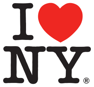
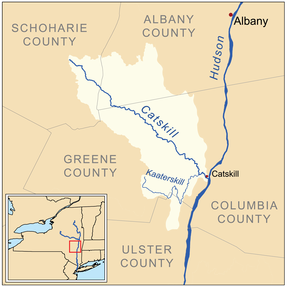
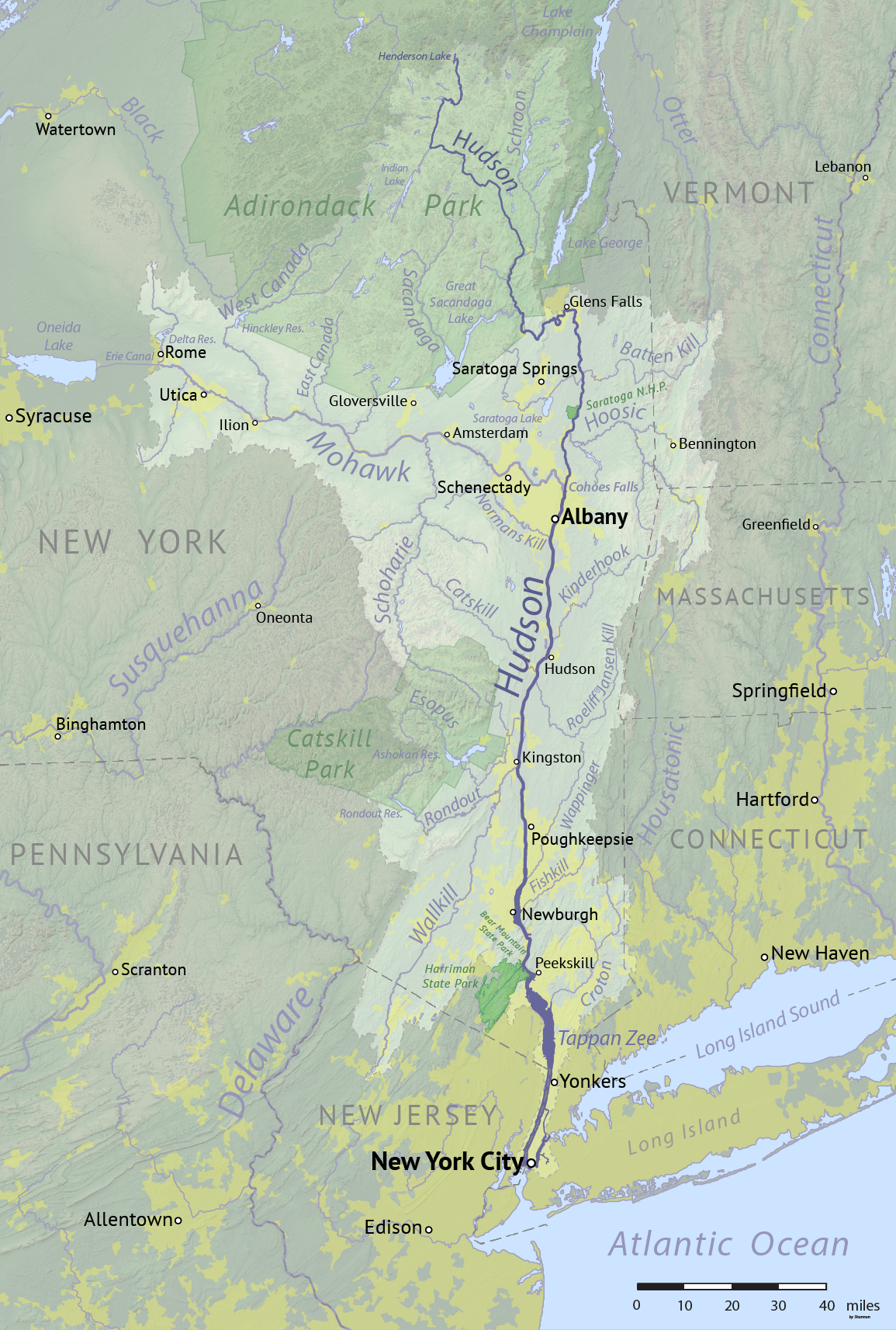
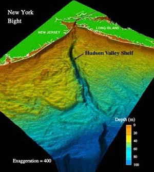
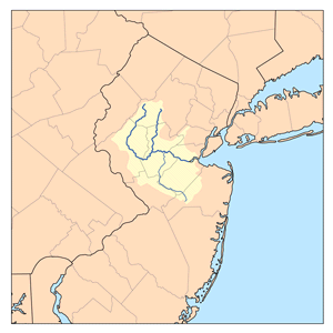
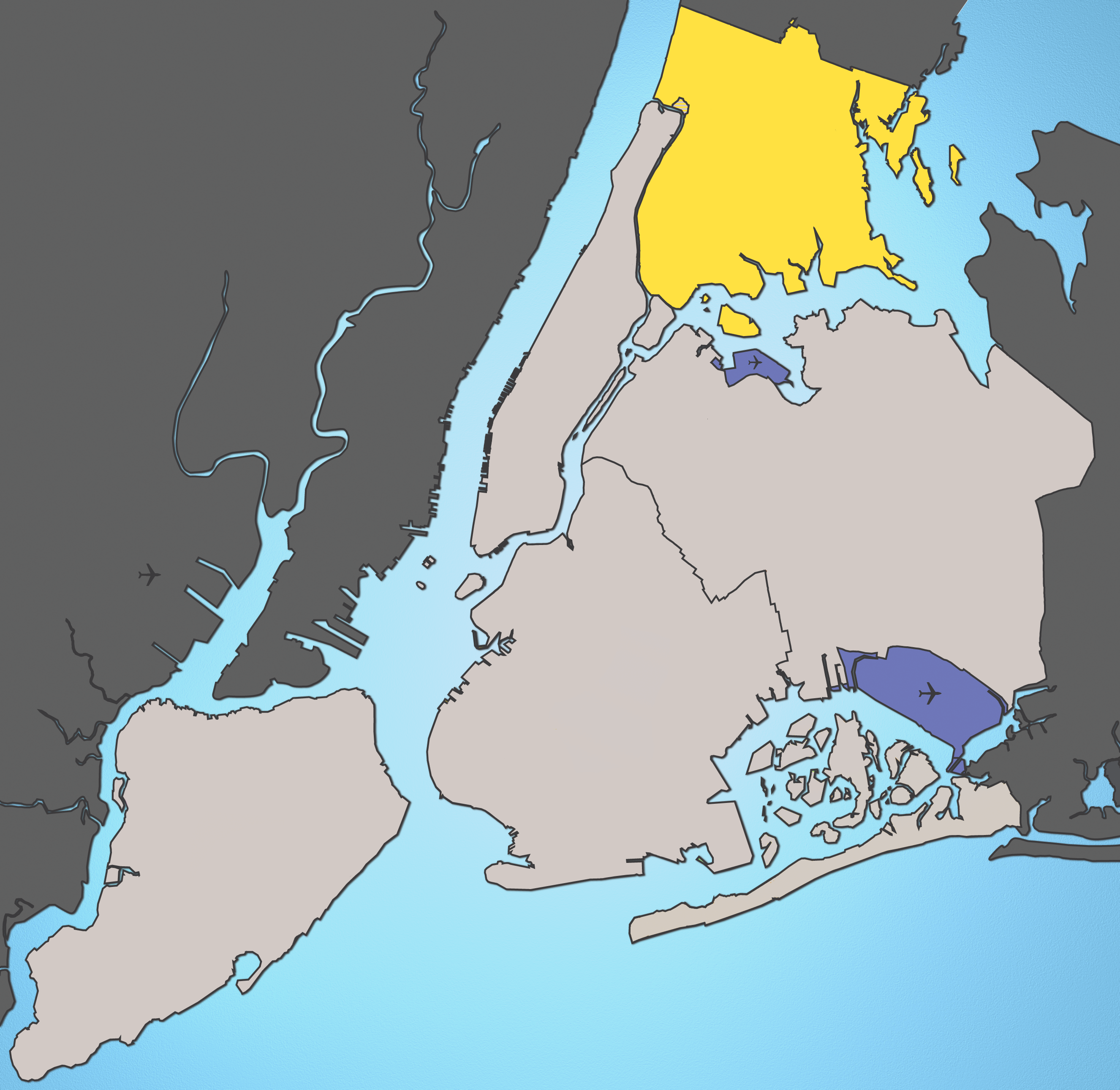