|
Reflections 2016
Series 1
January 11
Westward via Missouri I: Fulton & Winston Churchill-St Joe & The Pony Express
| | Day 8 (Continued): Fulton & St Joseph Other than leaving Elsah, then Alton at the Clark Bridge, and crossing St Louis and St Charles, this day is a long-haul driving day across the state of Missouri, end-to-end. I try to make these long-haul days infrequent, since driving alone along an interstate highway is little fun, but the time does pass surprisingly quickly. This is particularly true when there are two visits to be included, one on the way, in Fulton, and the other on arrival at our destination of St Joseph.
http://geology.com/cities-map/map-of-missouri-cities.gif
| | | | Crossing Missouri on this route between St Louis/St Charles and Kansas City/Independence oozes history. The Arch in St Louis celebrates the Westward Expansion. I personally describe the expansion route by the metaphor of a funnel lying on its side, the bell facing west. Settlers from the East reached St Charles and St Louis, then crossed Missouri, either taking a steamboat up the Missouri as far as they could go (to Independence in the Kansas City area) or the Boone's Lick Trail out of St Charles, or other routes. Picture this as moving up the tube of the funnel on its side. On reaching the destination, they got themselves outfitted with supplies and wagons and fanned out into Kansas across the Great Plains on historic trails to the southwest, northwest, or in between, representing the bell of the funnel. At any rate, crossing Missouri more or less at this point replicates the start of that Great Trek. | | | | When we came along here in 1968, we were still oblivious of how momentous this route was—we were just going to the West Coast by the most convenient route. I can only estimate that we crossed Missouri on US-40 in that era, in which interstate highways were either not yet built, or built only in bits and pieces. US-40 is not on this map, because when I-70 was built, it pretty much replaced the route of US-40, most (not all) of which disappeared, in a similar way to what happened to Route 66. But whichever way you cross at this point, there is westbound history underfoot. (Underwheel?) | | | | Fulton is the location of Westminster College, a private institution founded in 1851 as Fulton College, but whose name was changed to Westminster just two years later. We are only about an hour and a half beyond St Charles, and we're not stopping here just to break up the trip. It's an important destination, just as it was for us when we stopped here in 1968. The connection is with Sir Winston Churchill, and the year of his importance here is 1946. | | | | Churchill was out of a job, so to speak. Although he was now Leader of the Opposition, he'd been Prime Minister of the United Kingdom during the WWII years of 1940–45, but then, surprisingly, he lost out being reelected after the war. He remained out of office until he was finally elected Prime Minister again for the years 1951–55. It was also in that later comeback period that Churchill won the Nobel Prize for Literature, in 1953. | | | | John Findlay Green was a St Louis attorney who'd graduated from Westminster in 1884. As a memorial to him, the John Findley Green Foundation Lecture was established in 1936, with funding provided for lectures of international concern. Another requirement is that "the speaker shall be a person of international reputation." Lectures were given from 1937 to 1942—the names of the speakers are unfamiliar to me--but then stopped for the war years. It was then in 1946 that the most notable by far of all Green Lecturers, Sir Winston Churchill, was asked to speak. (Since then, his address has built a legacy that brought quite a number of more familiar names to speak at the campus as Green Lecturers, including four US Presidents, Margaret Thatcher, and Mikhail Gorbachev.) | | | | In the 1930s, Churchill notably warned about Hitler and Nazism, and he was looking to the future again when, on 5 March 1946, as a Green Lecturer at Westminster College, he delivered his "Sinews of Peace" speech, again looking toward the current postwar future. But most don't remember that speech by its official name. Most remember it as the Iron Curtain speech. This is the most notable quote from that speech: | | | | | | From Stettin in the Baltic to Trieste in the Adriatic an iron curtain has descended across the Continent. Behind that line lie all the capitals of the ancient states of Central and Eastern Europe. Warsaw, Berlin, Prague, Vienna, Budapest, Belgrade, Bucharest and Sofia, all these famous cities and the populations around them lie in what I must call the Soviet sphere, and all are subject in one form or another, not only to Soviet influence but to a very high and, in some cases, increasing measure of control from Moscow. |
| | | | He goes on to describe how Athens alone in Eastern Europe is free to decide its future, how the Polish government has been forced to expel millions of Germans on a grievous scale, how local Communist parties have been expanded, including in the Soviet zone of Germany, part of which the Allies had conquered, yet evacuated in favor of Russian occupation to fill out their zone. The tenor of his speech is such that it serves as a de facto announcement of the beginning of the Cold War. Correspondingly, when Mikhail Gorbachev spoke at Westminster in 1992, he was declaring the end of the Cold War. | | | | Exactly what is meant by the location of the Iron Curtain varied over time. For instance the extent to which Yugoslavia was behind the Iron Curtain changed. But as described by Churchill in 1946, this was the location of the Iron Curtain (Map by BigSteve). | | | | There is no doubt that Churchill's speech served as an acknowledgement of the start of the Cold War, although he didn't use that term. But from the safety of a distance of almost seven decades, we can discuss the use of the term "Iron Curtain", and also nitpick a bit. | | | | Churchill, the eminent orator, was using illustrative rhetoric when he described a vertical line slicing through Central Europe, and so we accept his declaration as that. However, even this map shows that the Iron Curtain also ran along the eastern border of Finland, and the northern border of Greece and Turkey—but of course, he did say Athens was on the free side, and in his list of capitals behind the Curtain, no Finnish, Turkish, or Greek capital was involved. And it would also seem that, over the years, Churchill's line in Central Europe was a more vivid image of the Iron Curtain than in more remote areas of northern or southern Europe. It should also be noted that the phrase never was applied to any borders in Asia. | | | | In his list of capitals behind the Iron Curtain, he included both Berlin and Vienna, as shown on the map, a reference to the Soviet Zone in Germany's East and the Soviet Zone in Austria's Northeast. But he defined his Iron Curtain vertical line in Central Europe as extending between two cities he used as landmarks, from Stettin in (on) the Baltic to Trieste in (on) the Adriatic. Let's look at them:
http://media.web.britannica.com/eb-media/41/64341-004-0D739460.gif
| | | | At the southern end, Trieste is indeed on the Adriatic (above). It's in Italy today, with its eastern suburbs in Slovenia, then part of Yugoslavia, so it can be seen that, at the time, the Iron Curtain ran through here. But take a look at this map of the Soviet Zone of Occupied Germany in 1945, a year before the speech. The blue line shows where the Allies met the Soviets at the end of the war, and therefore defines the territory that was to become part of the Soviet Zone that the Allies turned over to the Soviets, as Churchill mentioned. Note that cities such as Erfurt, Weimar, and Leipzig would have been part of West Germany if this had not been done. | | | | But the point of providing this map is this. On the right, find Stettin ([shte.TEEN], today in Poland as Szczecin [SH-CHE.tsin]), close to the Baltic. On the left, find Lübeck, also close to the Baltic, which always was in West Germany. Now if Churchill was including Berlin as being one of the capitals behind the iron curtain, he must have been including the Soviet Zone, so doesn't it seem that using Stettin as a landmark is inaccurate? Wouldn't Lübeck, and the border continuing from its area, have been the better choice? Go back to the Iron Curtain map, and that's just where the line is shown. But this is nit-picking. The speech remains great rhetoric, and provides great imagery. This is a good spot to point out that, when Churchill was awarded the Nobel Prize for Literature in 1953, he was cited "for his mastery of historical and biographical description as well as for brilliant oratory in defending exalted human values". In other words, it was awarded not only because of his considerable writings but because of his speechmaking. In that regard, the "Iron Curtain" speech of 5 March 1946 should be remembered along with the "Blood, toil, tears, and sweat" speech from 13 May 1940, the "We shall fight on the beaches" speech from 4 June 1940, the "This was their finest hour" speech from 18 June 1940, and the "Never was so much owed by so many to so few" speech of 20 August 1940, and certainly more. | | | | One of our recent themes, such as when discussing the St Louis World's Fair, has been differentiating between original use as opposed to popularization, and we have before us now, the perfect example of that. There is no doubt whatsoever that Churchill's use of the term "Iron Curtain" as applied to the Soviet Union's sphere-of-influence border in Central Europe is what made this use of the phrase popular. But again, this was popularization, not original use. | | | | As I see it from online research, the phrase fits into three periods of usage, each with its own meaning. The ● first is the generic, figurative usage of the phrase to imply any impenetrable barrier, since it's a simple and obvious metaphor: a curtain separates, and iron implies solidity. As an obvious metaphor, it could have been used at any point, and actually did develop extensively in theatrical use. To prevent fire from breaching the space between backstage and the auditorium, especially in the era of gas lights for theatrical illumination, fireproof safety curtains were used to separate the two areas. These are caused fire curtains in the US, and can be called iron curtains in the UK, regardless of the actual construction material, usually fiberglass. The safety curtain is also called an iron curtain in other languages, such as eiserner Vorhang in theaters in Germany and Austria and Järnridå in Sweden. | | | | | | There are some language—and travel--references here that we cannot let go by. The Swedish word for "curtain" ridå, pronounced ri.DOH, is a respelling in Swedish of French rideau, which we last encountered in Ottawa's Rideau Falls, thus named by Champlain because he felt they looked like a curtain of water.
When we talked about the fact that words in most languages for railroad/railway actually were phrased as "Iron Road", two examples were German Eisenbahn and Swedish Järnweg. Compare eisern, "[made of] iron" with Eisen "iron"; Swedish järn YAIRN, "iron" works in both words.
|
| | | | More abstractly, British author Arthur Machen used the term in 1895 in his novel "The Three Impostors": ". . . the door clanged behind me . . . and I felt that an iron curtain had fallen on the brief passage of my life." | | | | Those were general usages of the term. The other two examples both refer specifically to the Soviet Union, but in reference to two different borders. Therefore, our ● second use of "iron curtain" refers to the actual border of Russia-cum-the Soviet Union, and the term was used from after WWI, in the interwar years, and through to the end of WWII. | | | | A reference to Communist Russia separating itself from the West appeared in Vasily Rozanov's 1918 work "The Apocalypse of Our Time" (given the date, I find that title fascinating): "an iron curtain is lowering over Russian History." Although I do not have a specific quote, I've read that the first use in English of the term referring to the Russian border was in 1920 by Ethel Snowden in her book "Through Bolshevik Russia". However, we do have this delightful illustration in Swedish. This illustration appears in English Wikipedia, transferred from Swedish Wikipedia. It's the cover of a book printed in Stockholm in 1923 called "BAKOM RYSSLANDS JÄRNRIDÅ / PÅ MOTORCYKEL PETROGRAD-TIFLIS". The title translates as "BEHIND RUSSIA'S IRON CURTAIN / BY MOTORCYCLE PETROGRAD-TIFLIS". (Petrograd was the temporary name of St Petersburg before it became Leningrad, now again St Petersburg; Tiflis, now known as Tbilisi, is the capital of Georgia.) But do take note of the Iron Curtain being shown here as being the border of Russia (including Ukraine) and not farther west. | | | | As WWII progressed, there was fear in Nazi Germany about the Iron Curtain on the Russian border moving west. An article in a Nazi propaganda periodical was called "Behind the Iron Curtain". An article by the Nazi Propaganda Minister Joseph Goebbels warned that if the Nazis should lose the war, because of agreements made at the Yalta Conference, an Iron Curtain would arise in Central Europe. He said that "An iron curtain would fall over this enormous territory controlled by the Soviet Union . . . " | | | | And that is what happened, and is our ● third use of the term, after WWII and still referring to the Soviet Union, but with the Iron Curtain moving from its own border across Eastern Europe to a line down Central Europe. This is the Iron Curtain in the developing Cold War sense. Rather than literally bordering the Soviet Union, it now referred to a barrier at the edge of the sphere of influence of the Soviet Union. | | | | But Churchill was not the first to use the term even in this third and final usage. As Nazi Germany was collapsing in early May 1945 (V-E Day was 8 May), following Hitler's suicide, Goebbels replaced him for one day. Then after Goebbels' suicide, Lutz von Krosigk became Chancellor for three weeks, and was the last Chancellor of the Nazi period (Konrad Adenauer was the next Chancellor—of West Germany--in 1949). But as the first recorded oral international mention of an Iron Curtain in the most modern sense, as it moved forward from the Russian border to Central Europe, Krosigk broadcast to the German people on 2 May 1945: "In the East the iron curtain behind which, unseen by the eyes of the world, the work of destruction goes on, is moving steadily forward." | | | | It was in this very same month that Churchill first used the term in the modern sense, and his wording is eerily similar to Krosigk's. On 12 May 1945, he wrote in a telegram to President Truman: "[a]n iron curtain is drawn down upon their front. We do not know what is going on behind". He wrote in a following telegram to Truman on 4 June 1945, in which he lamented that US troops were backing up and surrendering gained territory to become part of the Soviet Zone, saying that doing so would bring "Soviet power into the heart of Western Europe and the descent of an iron curtain between us and everything to the eastward". Churchill first used the term in the House of commons on 16 August 1945 when he said that "it is not impossible that tragedy on a prodigious scale is unfolding itself behind the iron curtain which at the moment divides Europe in twain". | | | | US bureaucrat Allen Dulles then said on 3 December 1945: "[a]n iron curtain has descended over the fate of these people and very likely conditions are truly terrible. The promises at Yalta to the contrary, probably 8 to 10 million people are being enslaved". | | | | Thus, even in the most modern sense, Churchill and others used the term through 1945. But only when he used it at Westminster in Fulton on 5 March 1946 did the term become popularized and go round the world as being the de facto announcement of the start of the Cold War. | | | | | | While the term "Cold War" was just developing at that same period—it did NOT enjoy any sort of history whatsoever until WWII ended—Churchill did not use it in Fulton. The term, in the sense of "nonhostile belligerency" was apparently coined, in print, in October 1945 by George Orwell. He used it at that point in general reference to a threat of nuclear warfare. Then in "The Observer" on 10 March 1946 (five days after Churchill spoke in Fulton), Orwell became more specific as to Russia versus the UK, writing "after the Moscow conference last December, Russia began to make a 'cold war' on Britain and the British Empire." (It seems so logical that the author of "Animal Farm" and "1984" should have also authored the term "Cold War".) A year later, on 16 April 1947, US statesman Bernard Baruch popularized the term in regard to Russia versus the US in a speech where he said: "Let us not be deceived: we are today in the midst of a cold war." So, while Churchill didn't use the term at Fulton at the beginning, when Mikhail Gorbachev spoke there in 1992 declaring the end of the Cold War, it was by then a well-established term. |
| | | | To conclude discussing Churchill's visit and speech, we should say that he was awarded the honorary degree of Doctor of Laws (LL.D.). When the President of Westminster College conferred the degree, he said of Churchill: "A soldier, orator and statesman, by his indomitable courage, has made it possible to deflect the course of history, to turn back the totalitarian tyrants and to avert a cast and imminent danger to the freedom and to religion. I present for the degree of Doctor of Laws, Winston Spencer Churchill". | | | | Toward the start of his speech, the Churchill wit emerged noting the name of the College: "I am very glad indeed to come to Westminster College this afternoon, and I am complimented that you should give me a degree from an institution whose reputation has been so solidly established. The name 'Westminster' somehow or other seems familiar to me. I feel as if I've heard of it before. Indeed now that I come to think of it, it was at Westminster that I received a very large part of my education in politics, dialectic, rhetoric--and one or two other things. So, in fact we have both been educated at the same, or similar, or at any rate kindred, establishments." | | | | As early as 1961, it was decided at Westminster College to memorialize both Winston Churchill and the Iron Curtain speech. What was originally called the Winston Churchill Memorial and Library has developed into what is now known as the National Churchill Museum, commemorating his life as well as the speech. But one aspect of the museum is so unusual that it stands out as a reason by itself to visit Fulton. A genuine 17C London Christopher Wren church is part of the memorial, obviously the only Wren church in North America. | | | | Someone not knowing the full story would—and should—be infuriated by, and indignant about, that fact. How dare they remove a historic and artistic monument from where it stood for centuries in London? But such a reaction is baseless when one realizes bringing the church to Missouri actually saved it from being bulldozed. It would seem that therein lies a tale, and there certainly does. | | | | The church is called St Mary's Aldermanbury, Aldermanbury being the street in the City of London where it had been, opposite the Guildhall. Its history is remarkable, because there have been two churches by that name, a 12C one and a 17C one, both destroyed in great catastrophes that befell London. They therefore reflect major historical events. | | | | The first St Mary's Aldermanbury was built in 1181. It lasted almost a half of a millennium until it was consumed in the Great Fire of London of 1666 (Map by Bunchofgrapes), which wiped out much of Central London, as shown by the pink area of this map. It started in a bakery in Pudding Lane; the home of diarist Samuel Pepys (PEEPS) was not affected (see the brief Pepys reference in 2006/1). St Mary's Aldermanbury was located northeast of St Paul's, north of Cheapside, toward Cripplegate. | | | | A total of 88 parish churches were burned during the Great Fire, as was St Paul's Cathedral. The office of Christopher Wren rebuilt not only St Paul's (quite famously), but 51 of these churches, among them St Mary's Aldermanbury in its second incarnation, in 1677, which is the church in Fulton. It was among the first ones rebuilt, and Wren salvaged whatever original stones he could, and used the old foundation, so the 17C incarnation does retain elements of the 12C one. This is a postcard (postcards seem to preserve so many illustrations that have helped us over time!) of St Mary's Aldermanbury in 1904. Note the large tower at the front, the four large side windows with the fan window above. To this we add this drawing of the rear façade in 1839, as illustrated in "The Churches of London" by George Godwin of that year. Note the main window with the graceful scrolls on either side, the upper pediment and oculus window, the round window and doorway on either side. All these architectural features are not lost; we'll be seeing them again.
| | | | But as time passed, 16 of those Wren churches were willfully demolished as the residential population of the City of London declined in the 19C and the City became more commercial. Two more were substantially altered. But then came the London Blitz, the second of the two catastrophes affecting the Fulton church. It suffered a direct hit in 1940, destroying the roof, the interior, and all furnishings, leaving only the blackened walls and tower. (There is irony in that this church, that became the Churchill memorial, was blitzed in the same year that Churchill gave four of his most famous speeches—see above.) But it wasn't alone. Sadly, 13 other Wren churches were either destroyed or damaged during the Blitz. This next picture was taken almost a quarter century after the destruction and shows the blitzed St Mary's Aldermanbury in situ in 1964 (Photo by David Swindell). Neither the church nor its surroundings is attractive. | | | | So how did the church get to Fulton? In the mid-sixties, right about the time of the last picture, an article appeared in Life magazine showing the blitzed Wren churches in London that were soon to be demolished, and it came to the attention of the Westminster College officials. It struck them as appropriate that one of these churches could be imported to Fulton and restored, to be both a memorial to Churchill and to serve as the college chapel. The officials investigated, and chose St Mary Aldermanbury because of its relatively small size, because of its lengthy history, and because of its association with Shakespeare and Milton who attended services there. So in actuality, the college wasn't "stealing" a monumental and historic building, they were saving it from demolition after it had sat as a vacant ruin for a quarter-century. | | | | I am totally in favor of the building having been saved, and located on a continent that has no historic equal to it. However, I'd always heard that there were no funds to rebuild so many blitzed churches, so London officials were ready to cut their losses and tear them down. While the College's salvaging the church was a noble gesture, this no-funds interpretation alone makes it look even more noble than it was. I'm sure there's a lot of truth about the lack of funds, but many churches were indeed restored (see below), and precious few demolished (although St Mary's Aldermanbury would have been one of them). A much more significant factor, in my opinion, is that so many churches, even by Wren, were just no longer needed, given the ever-declining population of central London in favor of commerce. Just as 16 were willfully demolished in the 19C because of declining population, while many were indeed restored after the Blitz, others were simply not needed, and that to my mind is the stronger reason, backed up, yes, by funding problems, for the actual basis for decisions made in the 1960s. | | | | | | It behooves us to know what Wren churches do remain, especially after the Blitz damaged nearly all of them, some others also down to just walls and tower, just as St Mary's was. 13 Wren churches, including St Paul's Cathedral, survive today in their original form as Wren knew them. 9 were substantially rebuilt post-Blitz to Wren's original design (so some funding was indeed found). 6 were left as just towers with no churches at all, but that had happened in the 19C as well as post-Blitz. One was demolished just pre-Blitz, with its tower and interior going to another church. One as we know went to Fulton, Missouri, and three others that were destroyed in the Blitz had their ruins demolished afterwards indeed, which could have been the fate of St Mary's. I still maintain that, while there was considerable artistic and architectural loss, there really wasn't more than minimal bulldozing of ruins, which was not the impression I had gotten years ago. |
| | | | The foundation stone was laid in Fulton in October 1966, just over 300 years after the Great Fire of London of 1666, and seven months later, stone-by-stone, the last stone was in place. That was followed by two years of work to recreate the interior, which was done by English woodcarvers working from old photos. An American glass company manufactured window glass, and a Dutch company cast five new bronze bells for the tower. The fire warden who watched St Mary's burn in 1940, Noel Mander, built the organ, and was on hand to assure authenticity of the interior. The reconstruction is as Wren knew the building, with only two additions: an organ gallery in the west wall and a tower window to illuminate the stairway. | | | | The carefully restored church is the central element of the National Churchill Museum and it may surprise new visitors that the church is located on top of the museum! Both were dedicated on 7 May 1969. Only upon just reading this fact did I check exactly when Beverly and I were there the first time. Our travel diary for that year says it was on 27 June 1968, which was over ten months before the opening. The diary does say that we saw the church, but it must have only been the imposing exterior, with the interior still incomplete, and the museum not open yet, either. | | | | Well, we've gotten the church placed in its modern home, but haven't yet discussed what happened with its former location. A few years after the church left, its site was landscaped, and is now the St Mary's Aldermanbury Garden, one of very few gardens in the City of London, the area within the medieval walls (see fire map). While I've done my share of walking in London's City over the years, I've never walked down Aldermanbury and was unaware of the garden anyway, so let's all together take a virtual walk to the site.
http://media.dunkedcdn.com/assets/prod/76966/880x0_p194uvs0vd18edtmd2ua17l9htj6.jpg
| | | | This map shows the City today, and you can compare it to the fire map, which we'll reproduce here for the sake of convenience. In the west, match up Ludgate in the city wall, today Ludgate Circus (=Circle); in the east, match up the Tower of London; in the north, match up with the old wall the street called London Wall , whose name is self-explanatory. It's a compact area. | | | | | | Before we get to the point, let's do a couple of other things. Find London Bridge on both maps. On the modern map, find the Underground station with the cryptic one-word name "Monument". The name of what's located there is not any more explanatory: "The Monument". What you have to know (by telepathy?) is that the full name, which NO ONE ever uses, since it's so thoroughly embedded in the history of London, is "The Monument to the Great Fire of London". And so The Monument (Photo by Eluveitie), which, appropriately for us, was also designed by Christopher Wren, is just steps from Pudding Lane (one block east, running N-S), where the fire started. The Monument is 62 m (202 ft) high and that height is the very distance from the spot in Pudding Lane where the fire began. The Monument also stands on the site of St Margaret, New Fish Street, a church the fire destroyed that was NOT rebuilt by Wren.
Then scan the new map of the City to note how many churches you can still find, virtually all assuredly built by Wren. Don't be fooled when you come to St Mary Aldermary, which has a sound-alike name to the Fulton church. But as you note the number of churches you'll realize that the College taking one ruin has not really put much of a dent in the total of those remaining.
|
| | | | But to the task at hand. Find St Paul's Cathedral. As we said about the fire map earlier, what we want is to its northeast, and it's an 8-minute walk. Let's go down Cheapside (an unusual, quaint street name, as is its continuation, Poultry), and make a left turn on Milk Street (unnamed) which leads right to the Guildhall. When it finally borders the Guildhall, the street's name is now Aldermanbury. The white square NW of the Guildhall is St Mary's Aldermanbury Garden.
https://silvertiger2.files.wordpress.com/2013/01/20130106280.jpg
https://c2.staticflickr.com/8/7151/6479122283_f18e27b899.jpg
| | | | I have not been to the garden myself, but as we speak, friends Paul and Marya are again in the UK, and when they get to London, they will be staying in the area, and at my suggestion, will be visiting the Garden. Still, of the online pictures I've found, this part of the garden seems to be the foundations, the footprint, of St Mary's Aldermanbury church. And the neighborhood in this picture seems more serene than the one in the 1964 picture. I've also read that within this footprint has been added a memorial plaque placed by Westminster College, as in the second picture. So there we have it.
http://www.westminster-mo.edu/explore/Documents/CampusMap_14.pdf
| | | | We're ready to return to our narrative. We were heading west on I-70 (see Missouri map) and took an early turnoff for Fulton that leads at an angle into its east end, where signs direct us to the college further toward the west end. As the above campus map indicates (use + to enlarge), the college is centered along Westminster Avenue, and as luck would have it, the signs have led us (from the right) down Seventh Street. The intersection is overwhelmed by the church (#25), so we make an immediate right and park right at the corner, facing the rear façade of St Mary's Aldermanbury. | | | | Compare this view (click) with the 1839 drawing above. It's all there, just as we suggested then: Note the main window with the graceful scrolls on either side, the upper pediment and oculus window, the round window and doorway on either side. All these architectural features are not lost; we'll be seeing them again. And here they are. | | | | As we move around for a view from the south (Both photos by Ammodramus), we again see the tower, those four side windows, and the fan window above. Now review both pictures again to note how the church is perched on top of the museum, whose entrance is best seen in the second one. Also, hard to see in both pictures is this:
http://media-cdn.tripadvisor.com/media/photo-s/02/6e/ba/44/statue-of-churchill-speaking.jpg
| | | | It's a rather unusual flat (compare with second picture) bas relief, almost like a silhouette, of Churchill speaking, most likely during the Iron Curtain speech. It works only if you look at it face-on. | | | | | | I love that the church is here, and is really worth a visit. But I have to gripe about its placement. If you look at the campus map, you can see it's been placed at the corner of a raised quadrangle, so that it harmonizes with those other buildings. But that isn't what the visitor sees on arrival. The church looks odd from the street, perched as it is on top of the museum—you see the staircase to the main level--and, although it's startling when you drive up, the way it overwhelms the intersection is not good placement in the long run. |
| | | | The picture of the side shows the museum entrance well, located a half-level below the street, so you have the feeling you're going into a basement. It's a good museum, but as I said about the Lewis & Clark Museum in Illinois, it's really meant for the uninitiated. If you already are aware about Churchill, the Boer War years, the interwar years, as Prime Minister, it illustrates it all well, but is preaching to the converted. A half hour skimming the very nice exhibits is really sufficient. And also, it's worth noting that 2015 is the 50th anniversary of Churchill's death in 1965. | | | | | | But there was a pleasant surprise. The museum had both Karsh pictures of Churchill, the extremely famous one with the scowl, and the one Karsh himself preferred, the one taken moments later with a smile. See 2013/4 "Karsh of Ottawa". |
| | | | Only from the museum can visitors go up a staircase to access the church above, and see the simple, beautifully refurbished interior (Photo by Rangakuvara), and think about Shakespeare and Milton in attendance. | | | | Leaving the museum, one goes up those stairs on the side to the quadrangle level to see the church from eye level, as it's really meant to be seen, and there one encounters the Breakthrough sculpture, dedicated in 1990. It consists of eight sections of the Berlin Wall (Photo by Rangakuvara). While I've seen single sections of the Wall in two places in New York, and a lengthy stretch remaining on exhibit in Berlin, the eight sections here are the longest contiguous section in North America. With the two cutouts of people breaking through the wall, it's also the only part of the wall I've seen that's been made into a sculpture in this way. The artist was Edwina Sandys, who is Churchill's granddaughter, who wanted to commemorate the Iron Curtain speech and the fall of the Wall. It couldn't be more appropriate than to have the most recognizable section of the Iron Curtain on exhibit here. | | | | The juxtaposition of wall and church here (Photo by Rangermike) is also startling, the ugly next to the beautiful. And both these wall pictures show again the awkwardness of having the quadrangle higher than street level. | | | | | | Two other thoughts strike me. You always see the graffiti side of the wall, never the boring blank side. I'm not sure everyone realizes there's a difference. The graffiti side faced West Berlin, where little stopped graffiti artists from illicitly going up close to the wall. But the other side never got decorated, as it faced East Berlin, with minefields and the no-mans-land strip.
Graffiti is normally removed from structures, but this case is unusual, so it's left, for the above reason. But paint fades, and wears away in time, especially outdoors. To that point I ask the rhetorical question: On all the Berlin Wall monuments, will the day come when art restorers are brought in to bring the graffiti, originally illicitly placed there, back to their original state? If that happens, doesn't that seem a bit surreal?
|
| | | | Getting ready to leave Fulton, a sudden thought strikes. Everything we've seen appeared well after the speech. So just where did the Iron Curtain speech take place? A question asked of the clerk at the museum entrance gave the answer: at what is now known as the Westminster Historic Gymnasium. On the campus map, it can be seen south of Seventh Street at #5, so as we leave, we can drive up around the plaza to take a look. Although a National Historic landmark, the 1928 gymnasium (Photo by Ammodramus) is apparently still used as such, but is worth taking a look at. From here we swing down Fourth Street and back up to I-70. | | | | | | Jennie Jerome was born into a wealthy family in Cobble Hill, Brooklyn, when Brooklyn (until 1898) was still an independent city. (As a child, I once lived on Jerome Street in Brooklyn.) She later became Lady Randolph Churchill, in a Downton Abbey-esque story of a wealthy American woman marrying into the British nobility. She was also the mother of Winston Churchill. When visiting Blenheim Palace (BLEN.im) northwest of Oxford, I remember being shown the anteroom where Churchill was born, suddenly making his appearance during a ball. But I digress.
His partially American ancestry notwithstanding, Sir Winston Churchill was made, as this copy of the law shows, an Honorary Citizen of the United States of America in 1963, two years before his death. He was issued this Honorary Citizen's Document (Photo by LordHarris), which looks like a passport, but doesn't really function as one—it's just for show. Churchill was the very first of eight people to be so honored.
Only two were honored in their lifetimes, Churchill and Mother Theresa. Of the six honored posthumously, some are no surprise: Raoul Wallenberg, the Marquis de Lafayette, Casimir Pulaski. One is a very interesting surprise, Bernardo de Gálvez (see 2015/4, Galveston). One is confusing, William Penn; and one is very confusing, Hannah Callowhill Penn, his second wife. Apparently she administered the Province of Pennsylvania for six years when he was ill, and eight more after his death.
|
| | | | Check the Missouri map again to see that when in Fulton, we've only gone one-third the way to Kansas City, and to boot, we're actually headed to St Joseph (St Joe) northwest of KC. The logic might seem complex, but if we only have three nights to spend in this area, it's easiest for many reasons to spend them in three separate locations: St Joe, then back in Independence, and finally in KC. You'll see why as we progress. | | | | The route seems rather cut-and-dry. We pass Independence on I-70, then, in downtown KC, take I-29 to St Joe. But while it's easy to maneuver interstate highways in rural areas, doing so in unfamiliar big cities involves frequent exits, some on the left, heavy traffic, and other diversions. Fortunately, we make it through KC fine, and arrive in St Joe, which, like KC, is also on the Missouri River, at about 4 PM. Our problem is that the Pony Express Museum closes at 5:00, but, even after a long day of driving, our timing ends up working out just right. | | | | You cannot really understand the Pony Express heading west out of St Joseph until you realize that the west side of Missouri roughly borders the Great Plains, which extend north into Canada, where they are known locally as the Prairies, hence the Canadian reference to their Prairie Provinces. The Pony Express never would have existed but for the vast, empty wilderness (at the time) embodied by the Plains and the Rockies. The Great Plains/Prairies border is a north-south division of North America that perhaps not everyone always pictures. But as I see it, not only are we standing at a major line of division, but the entire mid-section of the continent, first the Plains, then the Rockies, form a low-population entity that divides the rest, both in the US and in Canada, into two parts each. Inspect carefully this population density map of the US as it is today:
http://www.ancientrails.com/wp-content/uploads/2014/10/US_Population.png
| | | | The largest region of contiguous populated areas is the East, with the situation in Canada being very similar, as the major populated area in Canada is between the Great Lakes and the St Lawrence. In the US, by far the densest population is in the Northeast (adjacent to Canadian density), which is a remnant of the heritage of the original settlers arriving in the four waterways of Cape Cod Bay/Massachusetts Bay, the Hudson River, the Delaware River, and Chesapeake Bay (2009/21-25). | | | | As we look at this map now in the 21C, the US has spread well beyond the Appalachians, and beyond the Mississippi (note in particular the population concentrated around St Louis). We are now in St Joe, immediately north of the KC area, and nowadays, the population is starting to fill in the beginning of the Great Plains, notably in the Dallas-San Antonio-Houston triangle (2015/2-3-4). But even today, West Texas is as empty as much of the rest of the Great Plains/Prairies, as well as the low-populated Rockies. Exceptionally, a few cities such as Denver, Salt Lake City, and Phoenix stand out in this region. But for most of the area, the old gag about Texas consisting of miles and miles of nothing but miles and miles still holds true. | | | | It's only upon reaching the Pacific Coast that we see a build-up of population again, in both countries, from Los Angeles via San Francisco, Portland, and Seattle to Vancouver. Why should this be? Why are the Great Plains/Prairies so flat, originally being empty grasslands (of which there is very little left), and consisting today mostly open farmland? Why are there no forests here as in the East and on the Pacific Coast? What is this—"interruption"—in North America? | | | | If, to understand the Pony Express you have to understand the Plains, then the next issue is just why those Plains are there. I always wondered about this open-area anomaly, so now I looked it up, and the answer makes perfect sense. Believe it or not, this non-coastal, central part of North America owes its look to our old friends, the tectonic plates, which we're used to seeing affect oceans and coasts, not mid-continents. | | | | Just recently, we saw tectonic plates splitting the Atlantic apart, causing volcanism in Iceland (2012/19). We saw "Miss India" (2014/8) ram herself into—and under—Asia and form the Tibetan Plateau. Just this year (2015/14) we discussed the Nazca Plate which includes the Galápagos Islands, and which is slowly sliding under South America, with the possibility that those islands will eventually disappear under the Andes. But everything here is coastal. | | | | Now let's check out what I've just discovered: we've lost an entire tectonic plate! It's gone! There are only fragments of it remaining, three to be exact. The ancient plate was called the Farallon Plate, named after some islands off San Francisco, and it has mostly subducted beneath (slid under) the Americas. Look again at the map of the tectonic plates to find the three remaining fragments that still exist today, each with its own new name. The largest remaining fragment is a southern piece and is one we've just discussed, the Nazca Plate, subducting under South America. Above that is the second, smaller, remaining central fragment, the Cocos Plate, subducting under Central America and Mexico. Finally, north of that, subducting under North America, is the smallest remaining fragment of the Farallon Plate, a fragment which itself is almost gone, the Juan de Fuca plate, named after the Strait between Canada and the US. | | | | The effect of this plate on North America occurred in the mid- to late Cretaceous Period, the totality of which ran between 145 and 66 million years ago. (It was also at the end of the Cretaceous that all non-avian dinosaurs became extinct.) I tried to simplify those numbers so I can picture it better. If the Cretaceous ran for about 80 million years as just mentioned, halfway would be roughly 40 million years. That would seem to mean that the events we're describing below lasted for the latter 40 million years of that Period, starting about 105 million years ago. | | | | As the Farallon Plate pulled under the North American Plate, there were two results, the first of which might seem nonintuitive. As the plate subducted under North America, it pulled the surface of the North American Plate DOWNWARD, that is, the land sank. This caused a north-south depression in the middle of North America that fell below sea level. First the waters of the Arctic (Ocean) Sea flooded south, then the waters of what is today the Gulf of Mexico flooded north, and both joined, forming the North American Inland Sea (what a great name!), also known as the Cretaceous Sea for obvious reasons. but also the Western Interior Seaway, as on the map, which I find not inclusive enough, in light of the other "seaways". | | | | I always need to visualize things more simply to understand them. I see a large rubber raft overloaded in the center so that it dips down under the water and floods, leaving the two ends of the raft above water and dry. That's exactly what happened to North America. The large eastern part became a huge island, referred to today historically as Appalachia, because of the mountain range, and the disjoined western part, somewhat smaller, became a long-narrow island that's been named Laramidia. Actually, these two large islands were themselves continents, much as Australia is an island continent. North-central Canada was apparently another island, and this seems to be where Greenland became separated from North America, as it remains today. | | | | At the end of the Cretaceous, events reversed themselves. A continuing uplift developed and raised the center of the continent again, draining the inland sea (the middle of the rubber raft dried itself out). The lifting started at about the Dakotas, and waters returned to the north and to the south. The northwest area drained completely into the Arctic (Ocean) Sea. I'm going to guess that the fact that the Mackenzie River flows in just that direction to this very day is a remnant of this. | | | | The Labrador Seaway didn't change much, and to this day, the Sea of Labrador and Baffin Bay continue to keep Greenland a separate island that has never physically rejoined North America. The Hudson Seaway emptied only partially, and the fact that Hudson Bay remains a huge indentation in North America is proof of that. Waters to the south also did not fully drain, leaving the Gulf of Mexico behind to continue to separate Florida from the Yucatán. Further tectonic uplift then caused the Rocky Mountains to form. | | | | So what does this have to do with today? Compare the Inland Waterway map with the map showing today's concentrations of population, and you'll see that North America remains divided into two populous areas, a larger one in the East, and a smaller one on the Pacific Coast. In between are two large areas of low population density, the Great Plains/Prairies and the Rockies. Let this map showing the Great Plains in pink (Map by TheDarthEgg) help to visualize the similarity of the Plains and the Inland Sea. The Plains exist today, and are flat, because they're a seabed. And as mid-19C settlers wanted to expand settlement to the west and therefore found themselves in western Missouri—and the Pony Express, as well—this was a "sea" to be crossed, and then the Rockies, if they wanted to reach the Pacific Coast. | | | | In the 21C, this population split remains between the larger East and the smaller Pacific Coast. It's even affected language. Jet setters fly to "The Coast", an unusual term that's always understood to mean the Pacific coast—or shall we say Laramidia? The central part of the continent, of low population, is jocularly called "flyover country". The separation of the two populated regions by the Plains and mountains has resulted in the term "out West", implying beyond the "empty stretches". Even more curiously, people on the west coast easily fall into using the term "back East", even if they've never been there. It's a historic, cultural, "back beyond the Plains" being referred to. | | | | Tomorrow, we're going to venture out on a short loop trip onto the Great Plains. When we're back in KC after that, we'll discuss how the settlers got outfitted there and moved west out of Independence and KC's Westport neighborhood; this lasted from the mid-1830s up to, and beyond the Civil War. But now we're in St Joe, and the matter at hand is the Pony Express that existed in 1860-1, toward the end of that period of westward expansion. | | | | While the geologic heritage of the Eastern half of the US ("Appalachia") being completely disjointed from the West coast ("Laramidia") is still with us to this very day, at least transportation (trains, roads, planes) and communication (telegraph, telephone, radio & TV, satellite connections) between them have been resolved. But in the mid-19C period we're looking at, it was as though an ocean still divided the continent in two. None of these connections existed. In order for (1) people, (2) freight, and (3) mail & news to move between the two disjointed sections of the US and Canada, major sea travel was needed in the Atlantic and Pacific. | | | | Given our recent discussion of the Galápagos and mainland Ecuador, we can name the two ocean options for connecting the coasts the Darwin and the La Condamine (although they sailed from Europe). Either you sailed for weeks from the East Coast around Cape Horn (or Strait of Magellan or Beagle Channel) as Darwin did to reach the Galápagos, or you could go overland in Panama (Map by Thoroe), as La Condamine of the French Geodesic Mission did to reach Ecuador. While this latter choice was shorter, perhaps, by eye, half the length, it had its own problems. First, it was a "three-seat trip": one's ship landed on the Atlantic (Caribbean) side of Panama at Colón, one then went overland to the Pacific side at Panama City, then took another boat northward. Check the map for the canal route, rail route, and road route. The Panama Canal wasn't built until 1914. The Panama Railroad was opened in 1855 to passengers and freight, which is indeed within our time frame, but it was the most expensive railroad of its day, tempting people to continue using the two three-century-old Spanish roads, the Camino Real trail and the Las Cruces trail. Presumably mail couriers could use either rail or road. But the second problem with Panama was disease, since cholera, malaria, and yellow fever were endemic. You could say that a passenger—or mail courier--took his life in his hands crossing Panama. In case you have difficulty empathizing with that situation, picture having to make transportation connections by crossing West Africa in the 21C and hoping you wouldn't succumb to ebola. | | | | The coming of the transcontinental railroad in the US in 1869 (and in Canada in 1885) took care of the passenger, freight, and mail situation between the two parts of the country, and the transcontinental telegraph in 1861 transmitted news and messages between them. These were the final links in a tight network of railroads and telegraph lines in the east, and the smaller network of railroads and telegraph lines on the Pacific Coast. This 1860 map of US population density should by now seem quite familiar:
http://users.humboldt.edu/ogayle/hist110/MapUSPopulation1860.png
| | | | It almost looks like the Inland Sea were still there, and this is just an earlier version of the modern density map we just saw. The East is a mass of high population, heaviest as always in the Northeast. The Pacific coast area has started to grow. Everything in between, Plains and Rockies, is extremely sparsely populated by Native Americans and a negligible number of settlers from the East. In the next decade, the 1860s, while rail and telegraph connections will be built, the Civil War will also break out. How does the US keep in touch with California before the rail and telegraph connections? More important, how does the US keep California from joining the Confederacy? Now, in the late 1850s, how can that mail and news breach be remedied without going to Panama? There's no rail and no telegraph. So how do you connect East and West overland? | | | | But if you do do something about the situation, it becomes obvious where it would be. In the West, the population concentration in central California is obvious. And in the East, it's equally obvious that Missouri is not only centrally located, but a well-developed populated area has developed right across the top of the state, from St Louis west to what would be developing into the Independence/Kansas City area, extended up to where we are in St Joe, and even spilling over to the adjacent Kansas Territory. This is due largely because of steamboat transportation up the Missouri River as well as the nascent roads developing cross-state, of which the modern I-70 we just used is a contemporary descendant. This map shows that almost all westward expansion will come via Missouri—so the Arch was well placed to commemorate it—and our Pony Express mail service will be coming out of this region as well. | | | | But contrary to what one might imagine, it didn't just appear out of nowhere. The US military had been building posts, forts, and supply depots which needed a steady stream of supplies. The government had at first contracted piecemeal with suppliers, but then realized it would be much more efficient to give a huge, lucrative, two-year contract to a single company. Three businessmen who had already been in the freighting and cartage business formed a partnership of merged stagecoach lines and renamed the new company the Central Overland California and Pike's Peak Express Company (COC&PP Express Company), its name not only indicating that it was the result of a merger, but that it had hopes of eventually getting a daily mail route to California on a central route. Three months after forming their partnership they got a two-year contract, not for mail, but to supply all the military posts west of the Mississippi River. The stage line made its first journey from Westport (now a historic neighborhood of KC) to Denver on 9 March 1859. Other lines ran from St Joe to Denver, and on to Salt Lake City. In May 1860 they took over a contract from another company for mail service, but just connecting Utah and California. | | | | But be sure to note what's missing: their contract involved military supplies, not mail, and between Missouri and Utah at the furthest. Whatever mail the stagecoaches handled on government contract was only between Utah and California, and was not known for speed. What could be done to get an even more lucrative government contract, particularly for the mail, between Missouri (and the East) and California (and the West)? | | | | The remarkable solution the COC&PP came up with was to establish an express mail service between these two points. They felt speed was of the essence, and decided that slow, lumbering stagecoaches couldn't do it anywhere near fast enough along that lengthy route. Mail couriers on horseback were the answer, they felt. And so was born what came to be known as the Pony Express, possibly the most romantic of many developments in the Western US, which has been extensively romanticized in general domestically and internationally, despite the Pony Express being so amazingly short-lived, existing for just 18 months in 1860-1861. | | | | While most of the history is available online, there were several things that I found out specifically at the museum in St Joe. Of particular interest were how the termini were chosen. The rail, telegraph, and steamboat network in California included both San Francisco and Sacramento, the capital. Since Sacramento lies further east, there was no problem choosing it for the western terminus. | | | | | | This is the B F Hastings Building (Photo by Steve Rouhotas) at 2nd and J Streets in the Old Town of Sacramento. It was the western terminus of the Pony Express, and today also houses the Wells Fargo Museum. While in the past I've been to Sacramento, and to its Old Town as well, I didn't know to go and find this building at the time. What an attractive period streetscape! |
| | | | But how about the eastern terminus? As was pointed out in the museum, three towns were candidates, all very close to each other, Atchison, Leavenworth, and St Joe. As for shortening the route, the first two lie just over the border in Kansas, and are already on the far side of the Missouri River, while a rider leaving St Joe, in Missouri, had to take a ferry. Still, St Joe won out to be the eastern terminus because of one single reason. All three towns had (1) adequate facilities to house the operation and (2) telegraph connections. But the two towns in Kansas had not yet been reached by the railroad, whereas St Joe had a rail link, making it the winner. | | | | The Hannibal & St Joseph RR connected those two iconic towns across northern Missouri and was the first railroad to cross the state. It had been formed in a meeting in the Hannibal office of Mark Twain's father (!!)—we'll see this later--and was completed in 1859, just a year earlier. So many of these timings are interesting, since this railroad not only facilitated St Joe being the terminus, but the railway also thus became an essential link in the entire Pony Express story. | | | | Inspect how this straight-as-an-arrow route is just north of the St Louis/Alton to KC route we just drove on I-70. Note how a courier departing St Joe on horseback would have to ferry across the Missouri River to Elwood KS, and most interestingly, note how Atchison (misspelled on the map) and Leavenworth, so near and yet so far, were left high and dry in the choice of the terminus, out of reach of the railroad. | | | | I suspect that many might have an unrealistically over-romanticized view of the Pony Express, perhaps even visualizing a rider going adventurously end to end, which is of course nonsense—the route is approximately 3,100 km (1,900 mi) long. It was done in relays. Just as in a relay race, where one runner after his stretch hands the baton on to the next runner, the mail got handed on, rider to rider. Numerous stations were set up along the route, some perhaps at local ranches, but many, as a display at the museum showed, nothing more than a flimsy frame shack covered in canvas, which served as "walls"—nothing romantic at all. | | | | Look at this illustrated map of the Pony Express Route. If you want it in another window for later reference, here's the direct link to the same map:
https://upload.wikimedia.org/wikipedia/commons/5/5f/Pony_Express_Map_William_Henry_Jackson.jpg
| | | | It's a reproduction dating from the 1960 centennial of the Pony Express of the period map in the Library of Congress issued by the Union Pacific Railroad. The dates at the top remind how short the 18 months of its existence were. The illustrations are fabulous. I particularly like how you can tell the variation in relay stations, from the fort at the top center to the shack-like relay station at the lower left. Note the mochila or mail-bag saddle to the right of the text, then read the text—we'll get back to the money-losing aspect--and its reference to the upcoming transcontinental railroad and telegraph. That tie-in is what I find great, because below the text it's explained that the map was made available through the Union Pacific Railroad, but that the lines of the railroad are similar to the Pony Express Route. It's for this reason that I like to consider the Pony Express a "railroad segment temporarily on horseback". Mail arrived by train in St Joe, was carried by horse across the missing rail link, then was turned over in Sacramento, and vice versa. (Actually, the "rail connection" in Sacramento was a steamboat on the nearby Sacramento River.) When the actual transcontinental rail connection was built, this intermediate "horse link" was no longer necessary and was abandoned. Still, it was vital for tying the decade-old state of California to the rest of the Union. | | | | The founding company wanted to deliver letters to California in ten days, a speed which many considered folly. This very specialized service would be very expensive. It started at $5 per half-ounce (14g), which is equivalent to about $130 today. It later dropped to $2.50 ($65 today), and toward the end, $1 ($26 today), a huge drop over 18 months, but which was still expensive—usually only businesses could afford these rates. The founders hoped to get lucrative, exclusive government contract to carry the mails, but that never happened. | | | | The Pony Express, which was actually a subsidiary of the COC&PP, was organized in two months early in 1860. The company arranged for 120 riders, 400 horses, and some 400 other personnel, including station keepers, stock tenders, and route superintendents. On the route map, I (painstakingly) count 144 stations—I can hardly imagine actually traversing the route. However, there were officially 184 stations in four divisions, so not all are shown on the route map, but are listed in toto in Wikipedia. Sacramento is listed there as the 182nd stop out of St Joe, then another station, then San Francisco actually being the 184th. When the steamer connection in Sacramento was, rarely, missed, riders continued on beyond Sacramento. | | | | Mail pouches in the form of saddlebags (Photo by Borsi112) were NEVER used on the Pony Express. They were too large, bulky, and unwieldy, they wouldn't attach well to a saddle, several might be needed, and repeatedly transferring them as individual pieces of "luggage" from horse to horse would take too much time and effort. | | | | Instead, the Pony Express developed a unique, efficient, one-piece carry-all to move mail quickly from horse to horse. It was a leather saddle cover—yes, cover--called a mochila with four attached pouches called cantinas. We saw a drawing of a mochila on the route map; there were several on display at the museum in St Joe; and this is a Pony Express mochila exhibited in the Smithsonian National Postal Museum, such is the importance of this innovation. | | | | | | It's curious that both names connected with this item are of Spanish origin, and have become part of colloquial Western-US English. Usually, a mochila is considered to be a backpack to go hiking with, but a little research to its origin is noteworthy. It derives from Spanish mochil (mo.CHEEL), which means "messenger", so beyond the hiking imagery, the word did start with original imagery reflected in the Pony Express use. Less important, but still of interest, is that mochil itself is a Spanish respelling of Basque motxil, pronounced the same way, and meaning "little boy", since it's the diminutive of motil, "boy". Now, with some imagination as to the imagery across three languages, picture a little boy being sent off with a message, the concept developing into "messenger" in general, and the messenger's pouch being named after the messenger. And then fast forward to where the word based on bringing news gets applied to, of all things, the Pony Express. Talk about meanings coming full circle.
But more confusing to me was cantina. It's come into English as a place to eat and drink, a cafeteria-like canteen, or a Mexican cantina, or bar. More digging was needed. Dictionary texts in Spanish pointed out that it could also be a metal milk-carrier, or a food carrier. Of course! English also uses "canteen" to mean a water carrier for travelers, and thus we see the imagery of a container of use when traveling. And so, we have a mochila with four cantinas hanging over the saddle—that is, a soft leather messenger bag with four hard leather compartments.
|
| | | | Note how the mochila was draped OVER the saddle with bits of the saddle sticking through it to hold it still. It was further held in place by the weight of the rider. In this position, the saddle didn't have to be moved at all to transfer the mochila to another horse. The mochila was made of thin leather, only about an eighth-of-an-inch (0.32 cm) thick. The cantinas held bundles of mail, messages, newspapers, even small packages, all of which was wrapped in oil cloth to protect it from the weather. Three of the cantinas were padlocked for safety. The only two keys to these locks were with officials at the opposite ends of the route. The fourth cantina was left open to pick up military dispatches along the way—remember the military purpose of much of the route. All in all, the mochila could hold 20 pounds (9 kg) of mail distributed in the four cantinas. Another commemorative from the 1960 centennial of the Pony Express was this US postage stamp, showing the route, mochila, and cantinas. | | | | In addition, a further 20 pounds (9 kg) of material were carried on the horse. At first that included a water bag, a revolver, a Bible, and a horn for alerting the relay station master to prepare the next horse. Since riders weren't allowed to weigh any more than 125 pounds (57 kg)—think "jockey"--there was a total of 165 pounds (75 kg) on the horse's back. However, in time, the Bible and horn were no longer carried. | | | | | | It's a shame that eventually it was felt that the horn was no longer needed. How romantic it must have been to hear a horn being blown in the distance to alert the workers to prepare the next horse. There is, of course, a great history of horns in the postal service, certainly in Europe, and posthorns remain the symbol of many postal systems, as well as elsewhere in European culture, such as in the name of this inn in Germany (Photo by Franzfoto). |
| | | | People using the service naturally moved to light, onionskin paper to save on weight, which was the all-consuming issue with the Pony Express. In that regard, it brings to mind the same situation in the 20C when dealing with airmail. In the period before all mail started going by the fastest route, air or surface, for a single price, modern letter writers had similar weight concerns. Not only was onionskin paper often used for airmail, but there also existed air letters, which folded back on themselves forming their own envelope, all to save on weight, and thus postage. | | | | The relay stations where horses were changed, were set around 10-15 mi (16-24 km) apart, which was considered about the distance a horse could gallop before tiring. The horses were ridden at a fast trot, canter or gallop, around 10-15 mph (16-24 km/h) and at times they were driven to full gallop at speeds up to 25 mph (40 km/h). Riders were changed every 75-100 mi (120-160 km) at the home stations, which were usually larger structures at a ranch, hotel, or town livery stable. Riders had two minutes to get a drink, go to the bathroom, and change the mochila over to a fresh horse, then ride both day and night, changing horses 8-10 times. If something went wrong and there were an emergency, a rider might end up doing two shifts back-to-back, and end up riding for over 20 hours. There were about 80 riders going east or west along the route at any given time. I find it difficult to imagine how this complicated schedule could be maintained so well—remember, there were no telegraphs, and certainly no phones, to call ahead if something went wrong! That was the whole point of the service in the first place! It's hard today to imagine communication in a simpler era. | | | | Pony Express envelopes were stamped when leaving and arriving, as shown by this Pony Express postmark, westbound out of St Joe. At first the system ran weekly, then moved up to twice weekly. Crossing the route took 10 days in the summer, but 12-16 days in the winter. Frederic Remington, famous for his depictions of the US Old West, painted the Coming and Going of the Pony Express four decades after the fact, in 1900. Note the look of this somewhat larger station, the tired horse on the right, and the eager fresh horse on the left, now carrying the mochila. The cantinas fit easily in front of and behind the rider's legs. Great action picture.
| | | | It should be obvious how much of this operation depended on the Pony Express riders. It will be probably far less obvious how very young these riders were. This is a typical advertisement for riders being told to apply to the Pony Express stables in St Joe, which we're about to visit:
http://1.bp.blogspot.com/-l0EzNWG5xtc/UY51vsOaUFI/AAAAAAAAAWU/NXoFYhX3zi8/s1600/PonyPoster.jpg
| | | | Immediately one notices they wanted small men, jockey types, and young men were more likely to fulfill that requirement. The ad points out the dangers involved, but there's no indication that very many applicants actually turned out to be orphans. But the thing that guaranteed many applicants is the unusually high pay offered. The riders were very well paid at $25 a week, or $100 a month, which works out to about $3.33 a day. A comparable wage for unskilled labor at the time was between $0.43 and $1 per day, so the riders were getting well over triple the best going rate. | | | | Since the service was so short-lived and was replaced by rail and telegraph, at first it wasn't a priority to maintain its records, so there's no complete list of all the riders. On its website, though, the Pony Express National Museum has a copy of its list inside the museum of 228 known Pony Express riders. The first two are listed with incomplete names, merely as "Black Sam" and "Black Tom", which would indicate that some riders were African-American. This 1860 tintype shows four of the original riders. While their names are all known, we'll just mention Johnny Fry on the upper right, who is generally considered to be the first westbound rider out of St Joe on the first day of service. He weighed under 54 kg (120 lbs) and was 20 in 1860. Afterwards he joined the Union Army and was killed during the Civil War in 1863.
| | | | But it's the youth of the riders that cannot fail to amaze. I saw the statistics in St Joe that the oldest rider was an "ancient" 41, while the youngest rider was—hold onto your hat—11. Look at this chart:
http://blogs.wf.com/guidedbyhistory/images/sm-chart.jpg
| | | | The purple sliver shows that only 2% were 35 and older. Green shows that 18% were 25-34. These two more-adult groups cover only a fifth of the riders. The large rust-colored slice of pie shows that 76% were 15-25, what we'd consider today upper teens and college-age. And the big surprise is the blue sliver, showing 4% were 14 and younger—those are early teens, and pre-teens. With the youngest at 11, in the US today he'd be a sixth-grader, followed by a lot of middle-school-age and high-school-age kids riding this route.
http://www.valleyviewranchvvr.com/uploads/9/6/7/6/9676584/6108308.jpg?451
| | | | I was happy to find this picture online. It's a modern picture of a reënactor, a boy portraying Pony Express rider Charley Miller at the age of 11. Furthermore, there are two riders who became well-known. American folk character James "Wild Bill" Hickock rode at age 23, and world-famous Wild West impresario William "Buffalo Bill" Cody rode for the Pony Express at the tender age of only 15. Talk about a youth culture! | | | | While infrastructure network serving the western terminus in Sacramento was small, the one serving the eastern terminus in St Joe was enormous, and mail headed for St Joe came from a wide area. However, I can document the location of only one office, in New York, from this 1860 poster (click). (Conjecture: perhaps mail in the East was sent via regular USPS to this office.) Noting the reduced rates, this must have been a later poster. When the poster speaks of forwarding to St Joe, it means by special courier traveling by rail, which further illustrates my point that the Pony Express can be considered a "railroad segment temporarily on horseback." | | | | | | This is a map of Wall Street and its area (Map by Hu Totya). 84 Broadway no longer exists, but would have been on the east side of Broadway just south of Wall Street. To judge, Trinity Church is at # 1 and has an address of 75 Broadway. This end of Rector Street is just a few blocks from me and is here I get on the Wall Street Station of the subway. I once worked as a translator of German and French for American Express when it was at 65 Broadway on the west side south of Rector. Small world. |
| | | | In a further, yet fruitless, effort to get a US mail contract, the owners of the Pony Express used the 1860 presidential election to promote the speed in which it could deliver mail. Check again the Pony Express route map, remembering that not all stations are shown, and find Fort Kearny in the Nebraska Territory, stop 26 out of St Joe, which was stop 1. The eastern telegraph line had already reached out across the Great Plains to Fort Kearny at this point in time. Before the election, the company hired extra riders to make sure fresh riders and relay horses were ready along the route. The 1860 election took place on Tuesday, 6 November, and on Wednesday, 7 November, a Pony Express rider left Fort Kearney with the telegraphed news of Lincoln's victory. | | | | Now over in Nevada Territory, find Fairview, stop 154. The stop east of that, which is not shown, is Fort Churchill, stop 153. Fort Churchill was by now the end of the western telegraph line. (Note how the doom of closure in favor of the cross-continental telegraph was already looming for the Pony Express!) From Fort Churchill, California's newspapers got word by telegraph of Lincoln's election only seven days and 17 hours after the papers in the East got it, which was an unrivaled feat at the time, and all to the credit of the Pony Express—which was still doomed, nevertheless. | | | | | | At this point, one topic is screaming out loud to be re-heard. In 2013/13, we discussed the first transatlantic cable from Heart's Content, Newfoundland (see map in that posting) to Ireland, successfully laid in 1858. It worked—barely—and was later abandoned. There were other attempts, with the first real success finally being achieved in 1866. Thus, when Lincoln was assassinated in April 1865, it still took a full 11 days for the news to reach Europe by ship.
Ponder the parallels between the Pony Express (and its being eclipsed) and the cable. Both took place in the 1860s; news about Lincoln was a factor on both; both involved week-and-a-half communication across the Great Plains or across the Atlantic.
|
| | | | During its 18 months of operation, the Pony Express delivered about 35,000 letters. However, while it grossed $90,000, it lost $200,000. The parent company, the COC&PP, was embarrassed by these losses, and it also had to suffer the expense of maintaining frequent stagecoach service. The American Civil War, which broke out on 12 April 1861, caused many mail routes to be closed down. Then, two days after the transcontinental telegraph reached Salt Lake City, finally connecting Omaha (north of St Joe—see route map) to Sacramento, making the Pony Express obsolete, the Pony Express announced its closure, on 26 October 1861. It had run out of cash and was sold for $100,000 to a stagecoach magnate who used the stations for his stagecoaches. The former route has now been designated the Pony Express National Historic Trail and about 120 historic sites along the trail may eventually be opened to the public, including 50 stations or station ruins. | | | | We need to comment on the name "Pony Express", since both words are used in English in a slightly quirky manner. Let's start with "express". | | | | We know it means a speeding up, as with an express train that skips stops. But in addition, the concept of "express mail"—including packages—is usually shortened to just the word "express". Therefore, when talking about an express service or an express agency, the reference is to speeding up mail, packages, and, by extension, freight, such as fresh flowers or frozen food. | | | | Typical of this was the Railway Express Agency (REA) , which was set up by the US government in 1917 to speed up deliveries by rail, and the reference here is to mail and packages, not passengers. It was in operation until 1975, when its business model was no longer viable, which was just what happened to the Pony Express over a century earlier. | | | | In the 19C, express agencies had been set up to travel the roads. In 1850, American Express (AmEx) was set up in Buffalo NY, and in 1853, William Fargo and Henry Wells set up Wells Fargo, also in NY State. Both companies started as express (mail) services, but only the former used the word "express". Both later moved into finance instead. | | | | In the 20C-21C we now have the United Parcel Service (UPS, 1907) and Federal Express (FedEx, 1971), again with only the latter using the word "express" to refer to mail and package delivery. | | | | So what's so unusual about "pony"? Consider the concept of "umbrella terms", words that include all others in the category. In the corpus "rose, aster, flower, peony", "flower" would be the umbrella term, since all roses are flowers, but not all flowers are roses. | | | | So what's the umbrella term in the corpus "pony, horse"? That would be "horse", since all ponies are horses, but not all horses are ponies. Agreed? | | | | The quirk in English is that there are common examples where "pony" is used as the umbrella term. To wit:
1) In the game of polo, played on horseback, the horses are called "polo ponies".
2) Someone who likes to bet on horse races is said to like to "play the ponies".
3) Most to the point, this express service on horseback was called the Pony Express.
| | | | I cannot imagine actual stubby little ponies being used in polo, or running around a racetrack, or carrying riders across the Great Plains. I can only explain that the umbrella term is turned on its head in some sort of ironic usage. Odd, and I'm sure it's unique to English. | | | | | | We need some fun. On the example of AmEx and FedEx, what if the Pony Express were called PonEx? Or, given the youth of the riders, what about KiddEx or TeenEx? If we try to use HorsEx, it becomes inappropriate, since it sounds like activity in a brothel. If we shorten it to HorEx, it's not much better, since it sounds like a sex worker's former husband. Let's stick to PonEx. |
| | | | Visiting St Joe & the First Westbound Ride We now have the background, let's go see what there is to see in St Joseph, and we'll also take the opportunity to follow the route of the first rider, then taken by subsequent riders. Take a look at this map of St Joe:
http://www.stjoemo.info/index.aspx?NID=149
| | | | Allow a moment for it to download, as we continue the narrative of our visit. We've been coming up I-29 from Kansas City, and then veer off to I-229 toward downtown. As you center on the lower part of downtown, click the + twice. There are four exits ahead for St Joe. It's safest to take the first one at E Lake Blvd. Hit + again. We turn left, and what luck! Typical of North American cities, the streets in St Joe are numbered (in this case, N-S) and 11th Street gets us right into town. We pass under US-36; it crosses the Missouri River on twin bridges known as the Pony Express Bridges, but don't be confused, as the name is merely honorific. The Pony Express riders actually crossed on a ferry further north in town. However, the first 120 mi (193 km) of US-36 westward into Kansas is known officially as the Pony Express Highway, since it roughly parallels the first stretch of the Pony Express route. | | | | We continue up 11th Street to Penn Street and turn left one block. Opposite Patee Park between 10th and 9th is the Pony Express National Museum (Photo by poster), housed in the original Pikes Peak Stables, named after the latter part of the COC&PP company name, but also known for obvious reasons as the Pony Express Stables (click). The pine-clad building was built in 1858, just before it was needed for the Pony Express. After a fire, another company remodeled it in 1888, keeping the original configuration of the roof and shingles, but re-siding the walls with a façade of brick. In 1950 the building was restored using original roof timbers and bricks, and is today the museum, listed on the National Register of Historic Places. Look at the stable doors on the left (click). They are the portals to history. | | | | We've been driving from Elsah this morning, via Fulton, and arrive at the museum at 4 PM, knowing it closes at 5. No problem, it all works out. When we go in, though, the clerk says that, since it's so late, we don't have to pay the entrance fee. Another plus. Now the museum is good, but like with Lewis & Clark and Churchill, we're already well caught up on the facts, so we needn't study the map of the route, list of riders, or other familiar things. Very interesting, though is the several mochilas on display and the model of the canvas-covered frame station. But when the clerk suggest we start "in the stable" to the left, we don't realize how powerfully evocative and memorable the main exhibit will be.
http://s3-media2.fl.yelpcdn.com/bphoto/vwMVpQ3IJi33B7NDJoMDQg/348s.jpg
| | | | It's called simply a "Moment in Time", but what a moment. You see a diorama with mannequins, but one where you can walk around and through it. The sign above the door says Moment in Time / 7:15 PM April 3, 1860 / The Pony Express Begins. We see a worker assisting Johnny Fry, mounted on the mare Sylph, which is to be the first horse of the day. As much tension as there is in this, it's secondary to the tension of the other worker with both hands on one of the doors, the same doors we just saw outside, about to throw it open to history. This door action is like the starter pistol of a race; door first, Fry and Sylph follow second. It's a very memorable diorama. | | | | But I've glided over another matter creating even more tension. Has something odd struck you? Have you wondered why this is happening as late as 7:15 PM? It's because it all almost went totally wrong. | | | | Riders were scheduled to leave both Sacramento and St Joe on April 3, and the Sacramento rider left on schedule. But things started to go wrong in the East. The courier carrying the first mochila left New York and Washington by train, but when he reached Detroit, he missed his train connection. By the time he arrived in Hannibal, he was two hours late, and the last train to St Joe had already left. | | | | But apparently the Hannibal & St Joseph RR realized the importance of its unique role in this historical moment. It cleared the track across the entire state of Missouri and sent out a special locomotive—appropriately called the Missouri--with one car attached for the courier. This picture IS NOT of that train, but of a similar H&SJ one. It sped across its route of 332 km (206 mi)—presumably stopping only for fuel and water— in a record 4h51, which was a remarkable average for its time of 68 km/h (42 mph). It arrived in St Joe, the westernmost US rail station, at what was then the depot on Olive & 8th, just three blocks north and one block west of the stable (see St Joe map). A flurry of dignitaries met the train, and the mochila was rushed to the stable. It contained 49 letters, five private telegrams, and some other papers for San Francisco and intermediate points. Thus, it wasn't until 7:15 PM that day that the stable door flew open and Fry and Sylph finally were able to leave on their historic journey, and still on the proper day. That mochila arrived in San Francisco at 1:00 AM on the 14th, having taken 10 days, 5h45. | | | | There are only 250 known surviving examples of Pony Express mail. This letter to San Francisco postmarked April 3 was one of those 49 that left with Fry on the first westbound trip, and is the only one known to exist. There are only two extant specimens of letters on that first eastbound trip, which arrived in ten days. From St Joe, western letters were placed in the US mails for delivery in the East. It's for this reason that I surmise that letters headed west were simply mailed to the New York Pony Express office—and perhaps to Washington—for courier delivery to St Joe. | | | | Back on our St Joe map, let's move from Patee Park and the museum at 9th & 10th up Penn Street a couple of blocks to 12th & 13th, where we find the former Patee House (Photo by poster). It, too, was completed in 1858 as a 140-room luxury hotel, and was one of the best-known hotels west of the Mississippi. But more important for our purposes, it was where the actual Pony Express office and headquarters were (click). Just as a hotel today might have a nearby garage, the Patee House used the Pikes Peak Stable for its own use, and for the use of the Pony Express office. Patee House later became a college, then a shirt factory, and since 1963, it's been a museum. | | | | You may have noticed on both pictures that this neighborhood around Penn Street is quite laid back, with some modest residences, a lot of vacant lots, and little traffic or parked cars. It's because we aren't really in downtown St Joe, which is further north. Apparently one John Patée built the Patee House as part of a development, here south of downtown, which he called Patee Town, including Patee Park, all located around the Hannibal & St Joseph Railroad Station. Little is left of that era except history. | | | | So let's go back to 10th Street and move north to the real downtown. It's easily recognized because of the street names. St Joseph was founded by Joseph Robidoux, a local fur trader, and incorporated in 1843. In its early years, it was just as bustling a place for outfitting wagon trains as the towns in the Kansas City area, Independence and Westport, serving as a last supply point for wagon trains moving west. Anyway, Robidoux named the main east-west downtown streets in St Joe after his eight children and second wife, so as we proceed north on 10th (hit +) we find we're downtown when we see streets named Messanie, Angelique (wife), Sylvanie, Charles, Edmond, Felix, Francis (François), Jules, and Faraon. | | | | When we reach 10th and Francis, a diagonal street forms a triangle, which is our next stop. The little park there contains the life-size bronze Pony Express Memorial Statue from 1940 (Photo by poster). You'll recognize the mochila and cantinas, and of course, the statue faces west. | | | | | | I have to interrupt with something I can't get out of my mind. You know that a recurring song in your head is called an earworm, a loan-translation of the German word Ohrwurm. I'm convinced that lines of poetry can also become an earworm, one that's been with me since starting to write this section on the Pony Express.
In my very first introduction to German, in German One with Dr Bernard at Brooklyn Technical HS, he in time asked us to memorize some lines from Goethe's Der Erlkönig / The Erlking, about a folkloric being that preyed on small children. The highly emotional poem deals with a father riding through the night for help, with his small son in his arms, who, in a fever, believes he sees the Erlking in the mists coming to get him. In the end, all is lost, and the child does die. The poem has a lot of both motion and emotion. The first two lines are:
Wer reitet so spät durch Nacht und Wind? / Es ist der Vater mit seinem Kind.
Who's riding so late through night and wind? / It is the father with his child.
I couldn't get this out of my head when thinking about the Pony Express riders, particularly the first line, so, with apologies to Goethe, I'm going to modify that line slightly. Taking away the W changes Wer? "Who" to Er "He". Now look at the above statue and picture this caption. Works for me, and puts the earworm to rest.
Er reitet so spät durch Nacht und Wind.
He rideth so late through night and wind.
|
| | | | But I kept on wondering why the statue is way up here and not near the stable, and a little more research explained it. This is apparently part of the route they took. As it turns out, the ferry across the Missouri to Elwood, Kansas docked at the foot of Jules and Francis Streets, due west from where the statue is. There were two steam ferries, the Bellemont Ferry and the Elwood Ferry that transported travelers, including the Pony Express riders, to Kansas and beyond. That means that Fry and Sylph would have come north, as we just did, then turned west to the river, for a total distance of about 800 m (0.5 mi). Sylph would have been changed for another horse at the first station, but Fry continued due west to Seneca, Kansas, stop 7 on the route map, which Google Maps says is 109 km (68 mi) on today's US-36 and would take 1h10 by car today. | | | | But it's been a long day, and we'll continue to our downtown hotel near the river. We go west along Francis Street (Photo by Tim Kiser), shown here at 4th Street with typical 19C architecture. Only a block from here, at Felix and 3rd, is the simple, but perfectly adequate, and more important, well-located, Holiday Inn St Joseph Riverfront. The upper-floor room requested does overlook the Missouri, but is blocked by the elevated I-229 (see map). Still, this is what the Missouri in St Joe looks like (Photo by Tim Kiser). We'll see it better when we cross it tomorrow south of town as we enter Kansas and the Great Plains.
| | | |
| |
|
|
|


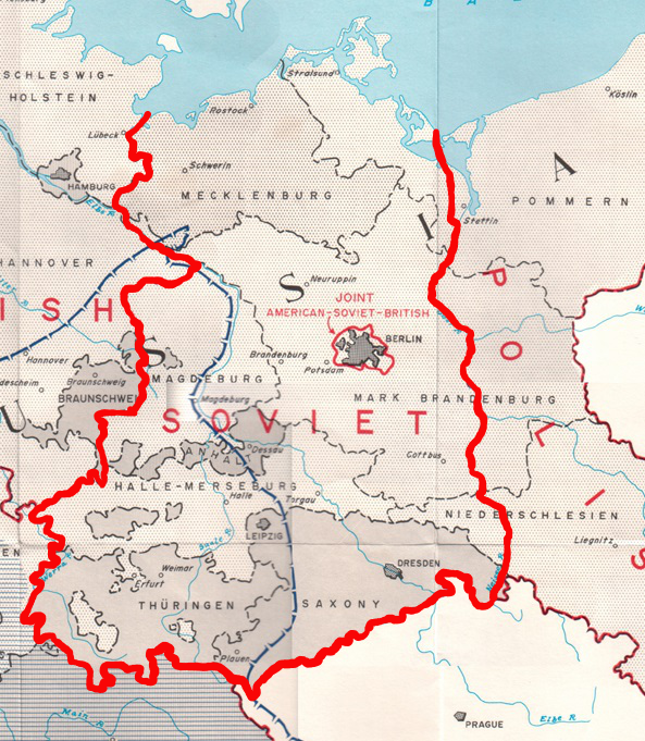
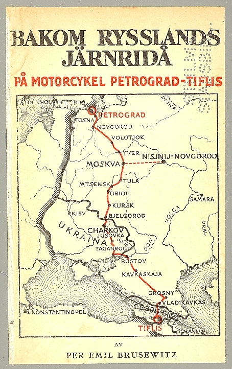
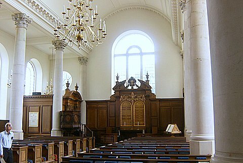
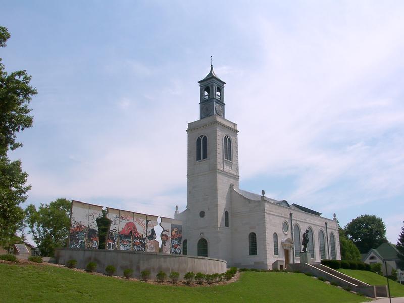
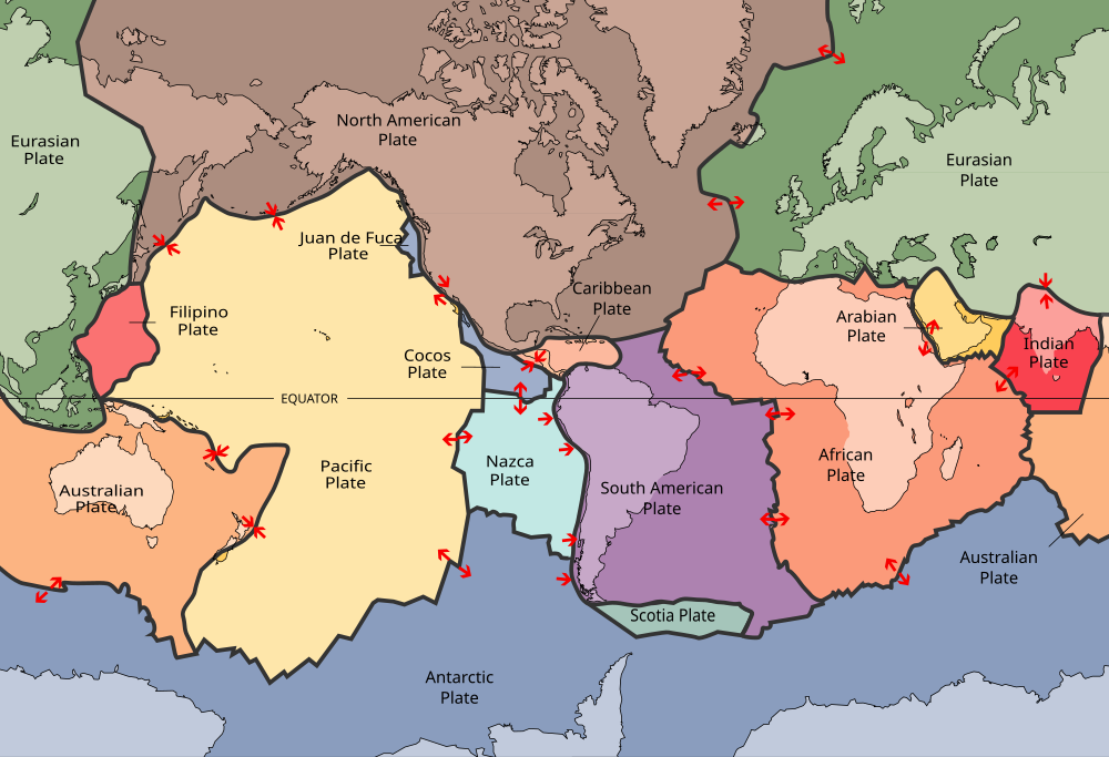
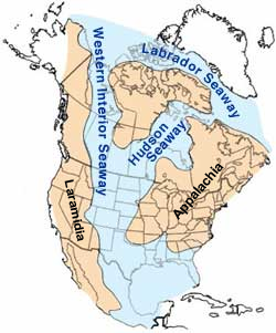
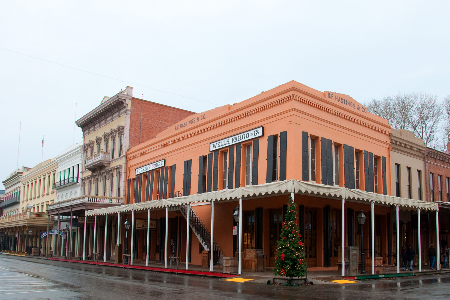
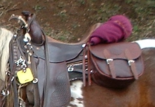
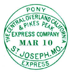
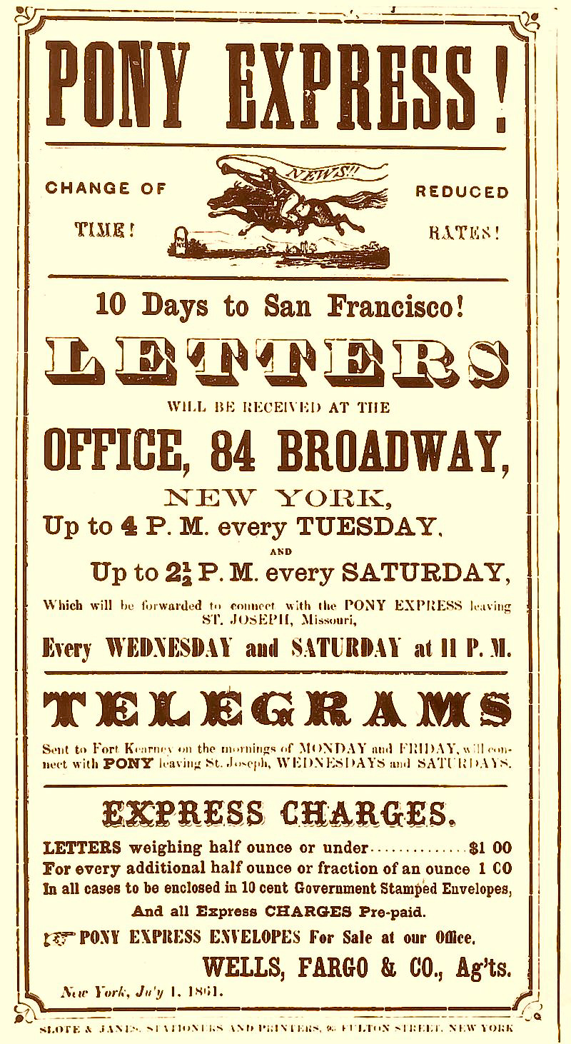
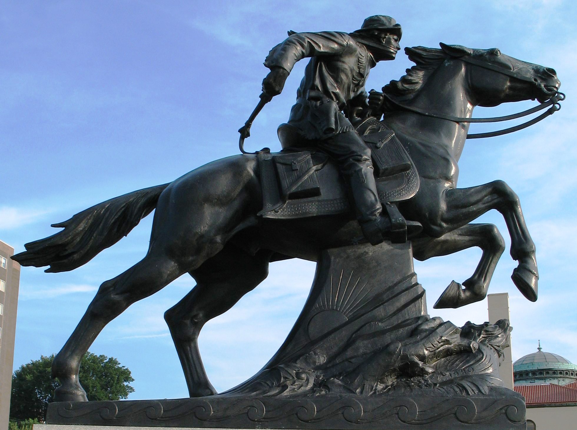
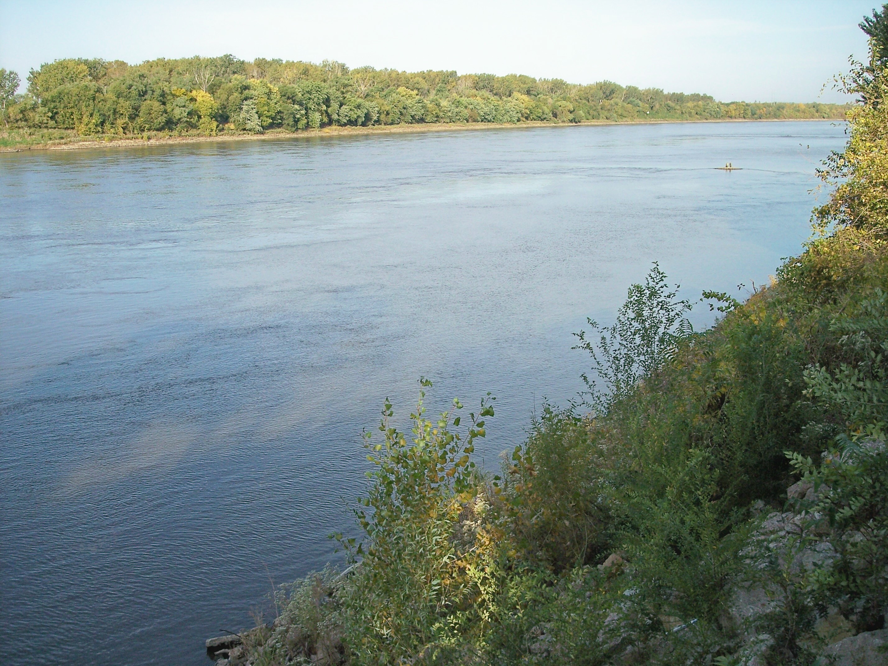