|
Reflections 2015
Series 4
February 28
Texas III: Dallas - Galveston
| | You may want to again copy and paste the map of Texas for easy reference:
http://www.lib.utexas.edu/maps/united_states/texas_2002.jpg
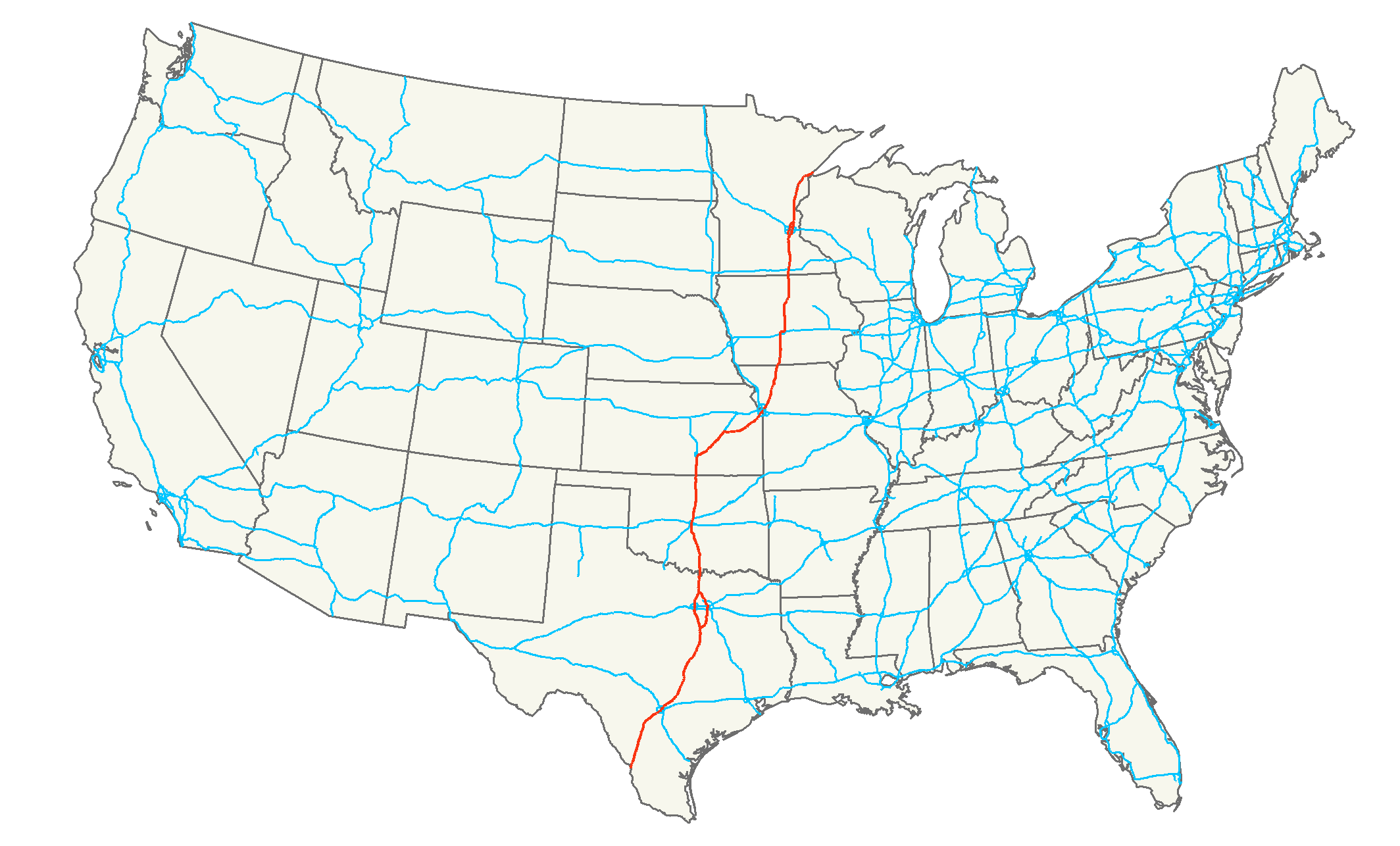
| | | | Dallas The LBJ Library was right next to an entrance to I-35, and off we went. I was familiar with the northern portion of the road in Minnesota, which runs from Duluth to the Mexican border, and of the quirk that it splits at the Twin Cities (click), with I-35W serving Minneapolis and I-35E serving Saint Paul. I thought that was unique, and didn't exist anywhere else. I now found out that not only does it exist somewhere else, it's at the Texas end of the very same road, where I-35W serves Fort Worth and I-35E serves Dallas, as you'll see here when you copy and paste this map we saw in the previous posting:
http://ecso.swf.usace.army.mil/Pages/Maps/Dallas_FortWorth_map.gif
| | | | So at the split, I kept right. But the problem with driving on an Interstate is the tangle of roads within an unfamiliar city. When almost there, I'd have to quickly switch on a left exit to I-30 for a bit before arriving at the hotel. I'd reviewed the route in advance, and was relieved when I made the connections correctly. But I'd have to use I-30 again the next day to get to I-40 (see map), which bothered me—but I found a way around that problem. Now copy and paste this map of Dallas that we also saw earlier:
http://www.johnnyroadtrip.com/cities/dallas/maps/downtowndallas.gif
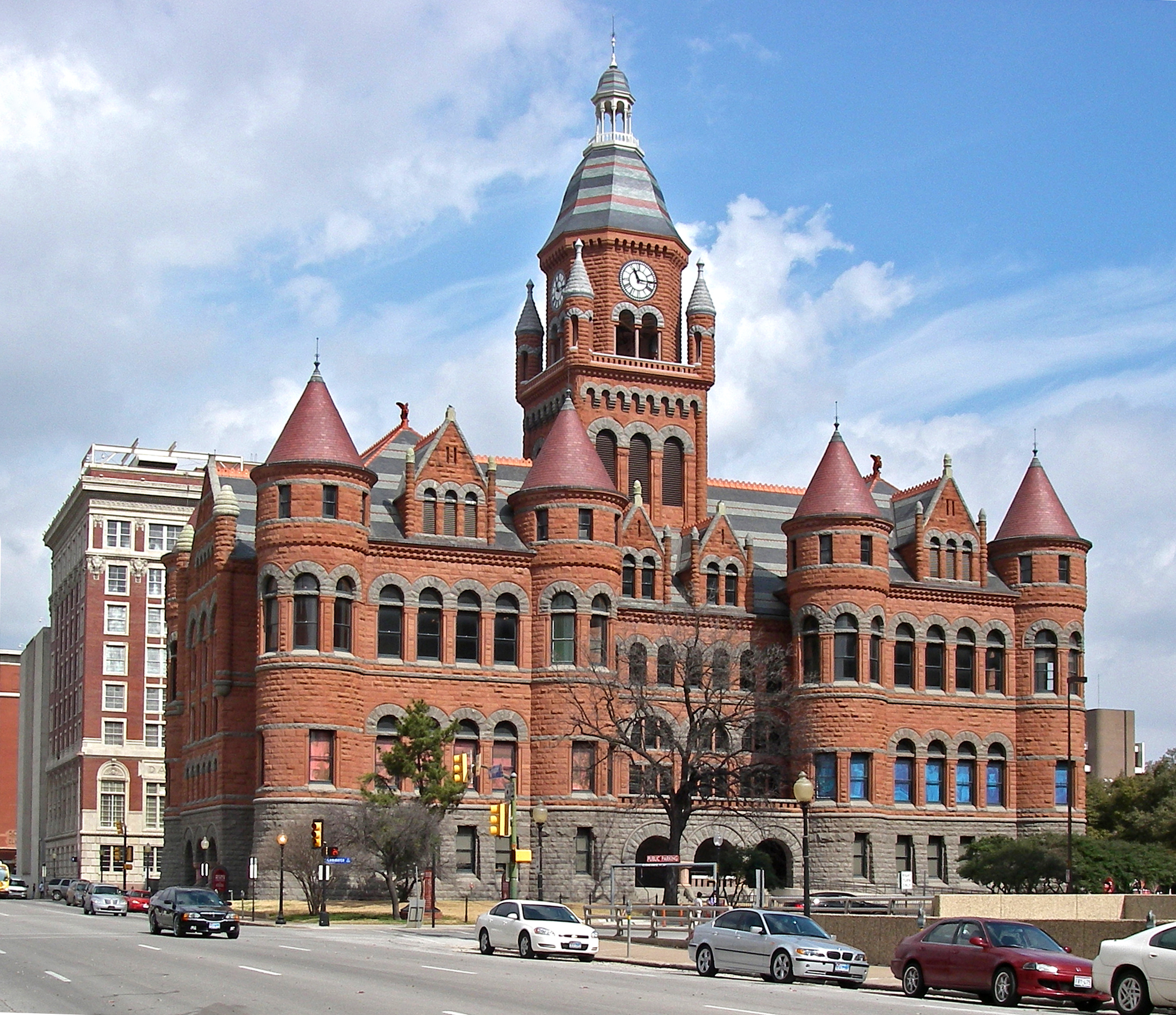
| | | | At the lower left, the tangle of two Interstates left me off under confusing overpasses where you see the number 77. But it was only a block to that circular road you see straddling the train tracks. The hotel is in the left semicircle and the Dallas rail station is in the right one, on the here unnamed Houston Street. My usual preference is a nice quite b&b, but my primary aim is location, location, location. The Hyatt Regency Dallas was a large glass box, not my usual choice, but well located for my purpose. The price was reasonable, and the front desk was very helpful. When I checked in, I asked for a town view. She warned me that I'd be facing the noise of the trains (there was no noise, and the view of Dealey Plaza was worth it), but I told her that was ideal for me. She also readily gave me a one-hour late checkout at 1:00 the next day, which I knew I'd need according to the plans I'd made. Everything was now in place for an informative late afternoon and following morning. | | | | There was maybe still an hour and half of daylight, so I just dropped off my bag in the room without unpacking and set out. The lower level of the hotel has a tunnel under the tracks, and you can exit up to the tracks or to the station—I tried both routes over the two half-days. Just to show how close I was to what I wanted to see, check the map to see that, when I reached Houston Street, I was between Young and Wood. One block over I was on Jackson, at the modern, rather nondescript Dallas County Courthouse. But one block further, on Commerce Street, is where I finally found the "delicious distraction" I referred to in 2015/1 when I was trying to use my few seconds' viewing time from the train to concentrate on Dealey Plaza, and this beautiful red building on the right drew my attention. And here it was, one block away. | | | | It was the former Dallas County Courthouse, on the National Register of Historic Places. It was built in 1892 of red sandstone, so popular with the Victorians, and it became known as the Old Red Courthouse. When the modern courthouse we just passed replaced it in 1966, it became a local history museum, and is now known as the Old Red Museum. It's in the Richardson Romanesque style we just saw on the bank in Fredericksburg, but this is a more magnificent example. H H Richardson, along with Louis Sullivan and Frank Lloyd Wright, form the triumvirate of leading American architects. This building is not by Richardson, but in his style that was so popular at the time, as is obvious by the massive, round Romanesque arches, most notable on the entry (click), but also on many windows. Beyond that, it's a Victorian castle. As we walk past it to the other side, on Main Street (Photo by Fredlyfish4), the arches at the entrances stand out even more. | | | | But turning about face here between Commerce and Main we see we're at the top of Dealey Plaza (see map), and between two of the three streets that merge here to go through the so-called triple underpass under the rail line. I'd always been confused by the geography of this area, but now it became quite clear. I now used the time I had late that arrival afternoon before sunset to walk all around the Plaza and learn what I could before visiting the museum in the morning. | | | | Let's step back and look at it from (approximately) the hotel room (Photo by Father of Nehrams2020). Actually, you may want to copy and paste it into a separate window, to be able to follow the following description more easily:
http://upload.wikimedia.org/wikipedia/commons/2/25/DealeyPlazaAbove.jpg
| | | | Now that last statement isn't exactly true. The view from the room was actually back a little further, and not at as good an angle. But this is the view of Dealey Plaza from above. You can tell here just how the Plaza developed as an urban embellishment. The rail line that the Texas Eagle had used comes up from Dallas Station (out of the picture at the bottom). There was presumably a grade crossing here at one time, but an underpass was built under the tracks. Rather than just sending Main Street (in the center) through it as it comes from downtown Dallas at the right, it was a graceful solution and a good traffic plan to include two other downtown streets, Elm Street, further left, and Commerce Street, further right, and so the three merge in the form of a trident. You'll now recognize the Old Red Museum between Commerce and Main, facing the plaza on Houston Street. | | | | And the Plaza was then landscaped into a park, which it still is, and named after George Bannerman Dealey, a local newspaper publisher and civic leader, who had campaigned for the area's revitalization. Dealey Plaza was completed in 1940 as a WPA project. Curiously, it had already been quite historic, since Dealey Plaza was the site of the first Dallas home, first courthouse, and first post office, from which the city grew. | | | | All four lawn areas of the park slope downward as the roads drop toward the triple underpass, and the two outside lawn areas have white, curved stone pergolas as an embellishment. The sloped lawn in front of the pergola on the far side is the one that became known as the "grassy knoll", where Zapruder took his film and where conspiracy theorists talk about other shots being fired. Along the upper side of Dealey Plaza along Houston street can be seen monuments that long predate Kennedy, although a Kennedy monument has been added to them. (I disliked the much larger, but rather ugly, monument to Kennedy on the back half of the block the Old Red Museum is on.) At the bottom of the "grassy knoll" in the middle of Elm Street is a small white circle indicating where John F Kennedy was assassinated on 22 November 1963 at 12:30 PM. The orange building near the far pergola was the Texas School Book Depository. Oswald's shot came from the rightmost window on the sixth floor, the floor with arched windows. This whole area is now the Dealey Plaza Historic District, which is a National Historic Landmark. | | | | There are various diagrams online showing the route of the motorcade, and I think this is the clearest one, now that we know the geography of the area. Copy and paste:
http://www.mapmanusa.com/images/book-maps/bill-oreilly-killing-kennedy-dealey-plaza.jpg
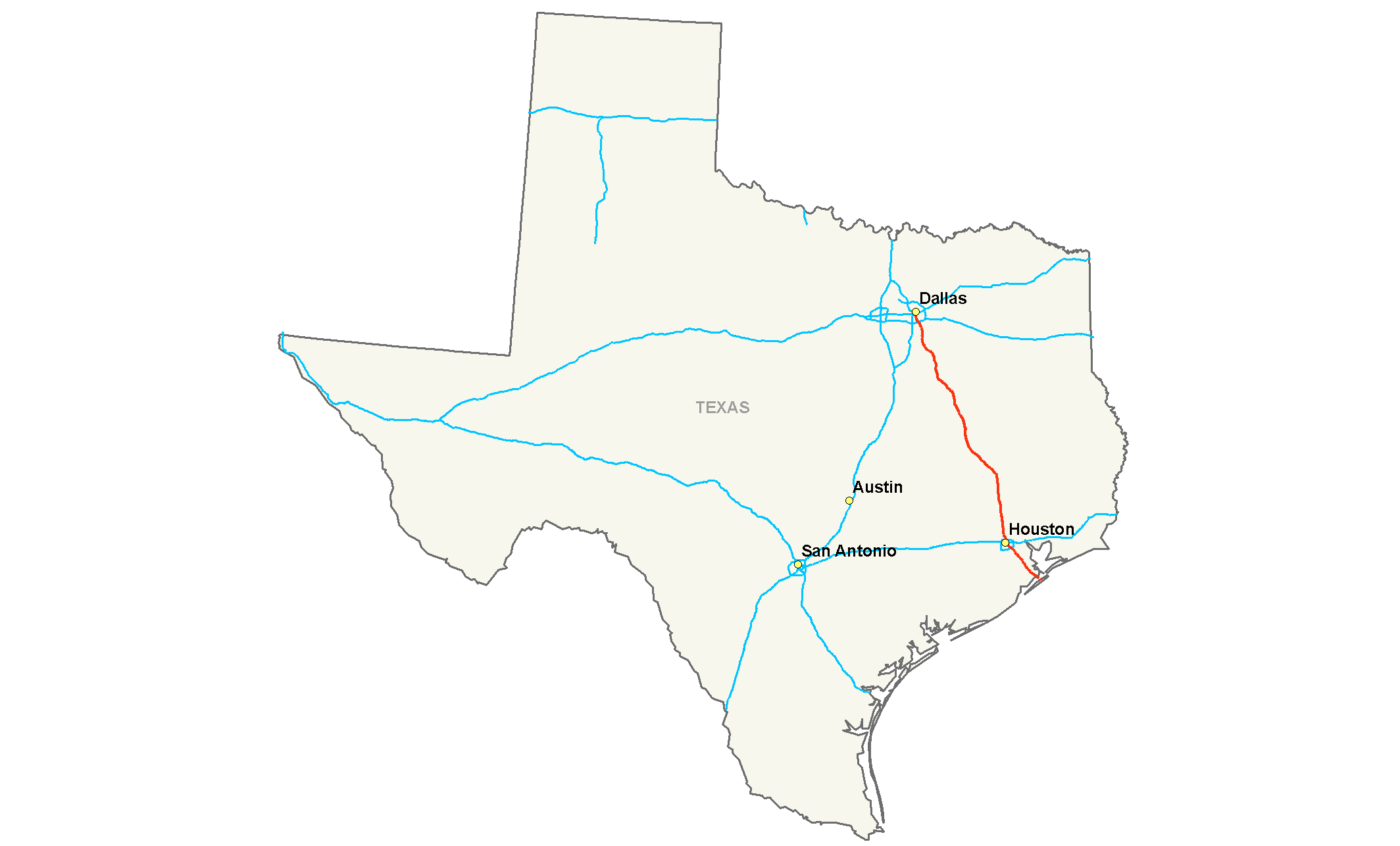
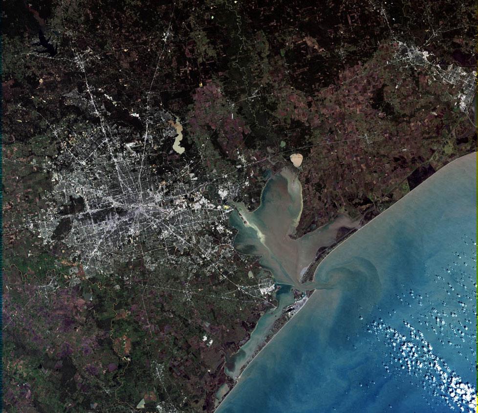
| | | | We've already discussed the geography of this sketch. The motorcade was coming down Main Street, and easily could have stayed there through the underpass. But it went out of the way, turning right onto Houston Street, and then turning left on Elm and taking that street towards the underpass instead. It would seem that that must have been done so that the motorcade could more easily acknowledge the people waiting there. One wonders if the car would have been less in the line of fire had they stayed on Main Street. | | | | I had found out online that the Museum opens at ten, and, because of great interest and little space, has a timed-ticket admission policy, where every half hour, only a certain number of people are admitted. It was recommended one buy the ticket online, and print it out. I bought my ticket enough in advance so that I had no trouble getting a ticket for the first group entering, at 10:00. | | | | I wanted to grab a quick breakfast beforehand, and walking down Houston Street the evening before, I'd noticed Cindi's New York Deli. It was busy, and had table service. They really knew what they were doing. My bagel with Nova lox had the requisite cream cheese and onions, and, as with the best delis, capers, the same item that makes Königsberger Klopse so good. I now retain a mental association of the odd juxtaposition of Dallas and bagels and lox. | | | | The building known in 1963 as the Texas School Book Depository (Photo by Andrew J Oldaker) had been rebuilt in 1903, after destruction by lightning, in the commercial Romanesque Revival style—notice the curved arched windows—which is less robust and massive than Richardson Romanesque. It had had various tenants in the first half of the 20C, in 1963 it was a multi-floor warehouse for the storage of school textbooks, and was also an order-fulfillment center. When I was there I was interested to learn that the company had just leased the building a few months earlier, so they were not any sort of long-standing tenant, or even owner of the building. On top of that, I learned that Lee Harvey Oswald had just applied for a job with them one month before, and was a temporary employee. I find it so odd to see how events align all at once to make history. | | | | The Texas School Book Depository Company moved out in 1970, and in 1977, the building was purchased by Dallas County. The lower five floors were renovated for use as county government offices, and the building is now officially called the Dallas County Administration Building. In 1989, the sixth floor opened to the public as the Sixth Floor Museum at Dealey Plaza containing Kennedy-related and assassination-related exhibits. In 2002, the seventh floor, which seems to have been something of an attic area, opened as a gallery, but when I was there, a temporary exhibit had just closed and there was nothing to see up there. The museum was founded by the Dallas county Historical Foundation, rents the space from Dallas County, and is self-sufficient in funding, relying on ticket sales and donations. | | | | Take another look at the last picture. The right side is on Houston Street, and the left side, with the front entrance, is on the Elm Street side of Dealey Plaza. The fatal window is on the Dealey side on the sixth floor with rounded windows, but is the last, unrounded, window on the right. I joined others who made the mistake of walking up to the front entrance, which has nothing to do with the museum. A sign says that's the entrance for the five lower floors of offices, and one should make two right turns to get to the back of the building for the museum. | | | | The entry to the museum is quite clever, effectively making it a totally separate unit from the main part of the building. There was a one-story ticketing area attached to the building, and then an external elevator attached to the building going up to the 6th (and 7th) floors. Some of the 10:00 people had already started entering, and there was a substantial line of last-minute planners waiting, four abreast, for the next open entry period. I flashed my printed-out ticket, and was waved right inside. | | | | Moving from exhibit to exhibit, panel to panel, photo to film, there's the story of the Kennedys, the reasons for their visit to Dallas and how the events occurred, including Jack Ruby shooting Oswald. It reviews how four government investigations pointed to Oswald and how at least five witnesses said they saw a rifle at the window in question. Still, there are those who say that some people at the time, believing that there were shots coming from the grassy knoll, dropped to the ground, and that some saw two men and a puff of smoke there. | | | | On reaching the window in question, one finds a corner display behind two plexiglas walls, cordoning the area off completely. There are piles of blank boxes simulating the boxes of textbooks that would have been there, including some piled up at what is referred to as a sniper's perch, with three spent shells. The window is somewhat open from the bottom, although in reality blocked with plexiglas. While you can't go up to that window, all the next windows on the right, the round-top ones, have the same view, so you can judge for yourself. However, over all the years, trees have grown considerably, so it doesn't look the same. Later, when one is diagonally across the 6th floor, there's another plexiglas area with boxes behind, showing where the rifle was found that was traced to Lee Harvey Oswald. | | | | There was one poignant photo on display that was unique, in that it didn't show anything, but that was just the point. It was taken on the other side of the triple overpass and shows the backs of people waiting for the Kennedys and looking toward the underpass, wondering where the motorcade was. Seconds after this picture was taken, the motorcade would have come zooming through on the way to the hospital. | | | | The video of the funeral was the most emotionally wringing. It showed Big Ben tolling every minute for an hour. It showed religious services of all kinds, all over the world of many religions. It showed marchers in Berlin, some holding Kennedy's famous "Ich bin ein Berliner" quote, and others saying "Wir haben einen Freund verloren"/ We've lost a friend. | | | | Leaving the museum, I went and stood next to the plinth at the corner of two walls next to the grassy knoll, on top of which Zapruder stood when he took his pictures, and also stood, as others did, on the white spot in the middle of the Elm Street side of Dealey Plaza marking the fatal location. | | | | I went back through the tunnel to the hotel, and checked out. The timing was good, since it was 12:45 and I had gotten the late checkout at 1:00. Knowing it was a long ride still to Galveston, and being concerned about getting on that tangle of interstates behind the hotel, I was glad that the night before, Google maps had given me an easier, and quite pleasant route, given the emotional morning. On the Dallas map, you'll see that Hotel Street leaves from the side of the hotel instead of from the back. It goes, on this quiet Sunday afternoon downtown, over and under various highways, but then delivered me exactly to the entrance ramp of I-45, southbound, leading via Houston to Galveston (see Texas map). A perfect ending to a tightly scheduled and very brief Dallas visit. | | | | Passing Houston Most people are aware that the primary interstates end in zero for east-west routes, and five for north-south routes, most of these going totally across the country. Therefore I was surprised when I found out that I-45 does no such thing. It starts in Dallas, and goes via Houston to Galveston. In other words, I'd be driving the entire length of a "primary" interstate this afternoon. I-45 is the only inTRAstate inTERstate ending in five that does this. It's the only primary interstate entirely within one state, and the shortest primary interstate. | | | | The long solo drive via Houston to Galveston wasn't that bad, but going through the tangle of interstates within Houston was difficult, since there was suddenly a lot of traffic on a Sunday afternoon, and some connections between highways were left exits. This is the intersection of I-45 and I-10 in downtown Houston. But it went fine. | | | | There was nothing that had interested me enough to stop in Houston. Although I've never shown that much interest in the space program, I paid my hommage to it in Florida when we visited the Kennedy Space Center at Cape Canaveral. But Houston's name remains attached to the phrase "Houston, we have a problem" from the Apollo 13 moon flight. Actually, no one ever said that. What was actually said was "Houston, we've had a problem", but everyone will always remember the misquote, which perhaps is more dramatic, the present tense implying more the possibility of being able to do something about it. There are other phrases that were never said in the way they're remembered, such as "Play it again, Sam" (it was "Play it, Sam, play 'As Time Goes By'"). Other phrases were never said at all in the original, but appeared in later versions, including "Elementary, my dear Watson", which is Hollywood hype added to a movie. It's gone so far that now there's even a Sherlock Holmes-type TV series called "Elementary", concentrating all this falseness into a single word. Understanding how the human mind chooses—chooses—to remember things can be fascinating. But I digress. | | | | Until reaching this area, I never realized the extent that Galveston today is an adjunct to Houston, since it's really quite close, although in reflection, given the earlier importance of Galveston, I suspect it was the parent and Houston its child that did well and surpassed the parent in importance. Review this map, since this is our last stop in Texas and the large Texas map doesn't show it as well as this unfortunately rather small map. You see the tangle of interstates in Huston, with I-10 going on toward Louisiana, our following destination. You see I-45 coming in from the north, then going on to its terminus in Galveston. | | | | The upper part of the bay you see is Trinity Bay, into which the Trinity River flows, but the lower portion is Galveston Bay. You can see that shipping for Houston must pass Galveston. Notice the secondary, more easterly route from Galveston to I-10 via Texas City. You can see the barrier island called Galveston Island, with Galveston at its eastern end, and the Bolivar Peninsula, named after the South American hero, with Port Bolivar facing Galveston across the entry channel to the bay. Whenever one sees a peninsula like this, one suspects it might have once been a barrier island that eventually became attached to the mainland, but I don't now. | | | | We'll use this wide-area map again to show our exit route from Galveston, and for now, it'll be of interest to inspect this satellite image of the same wide area. After that, as we approach the city, copy and paste the link to this medium-range map:
http://www.thecityofgalveston.com/galvestonmap.html
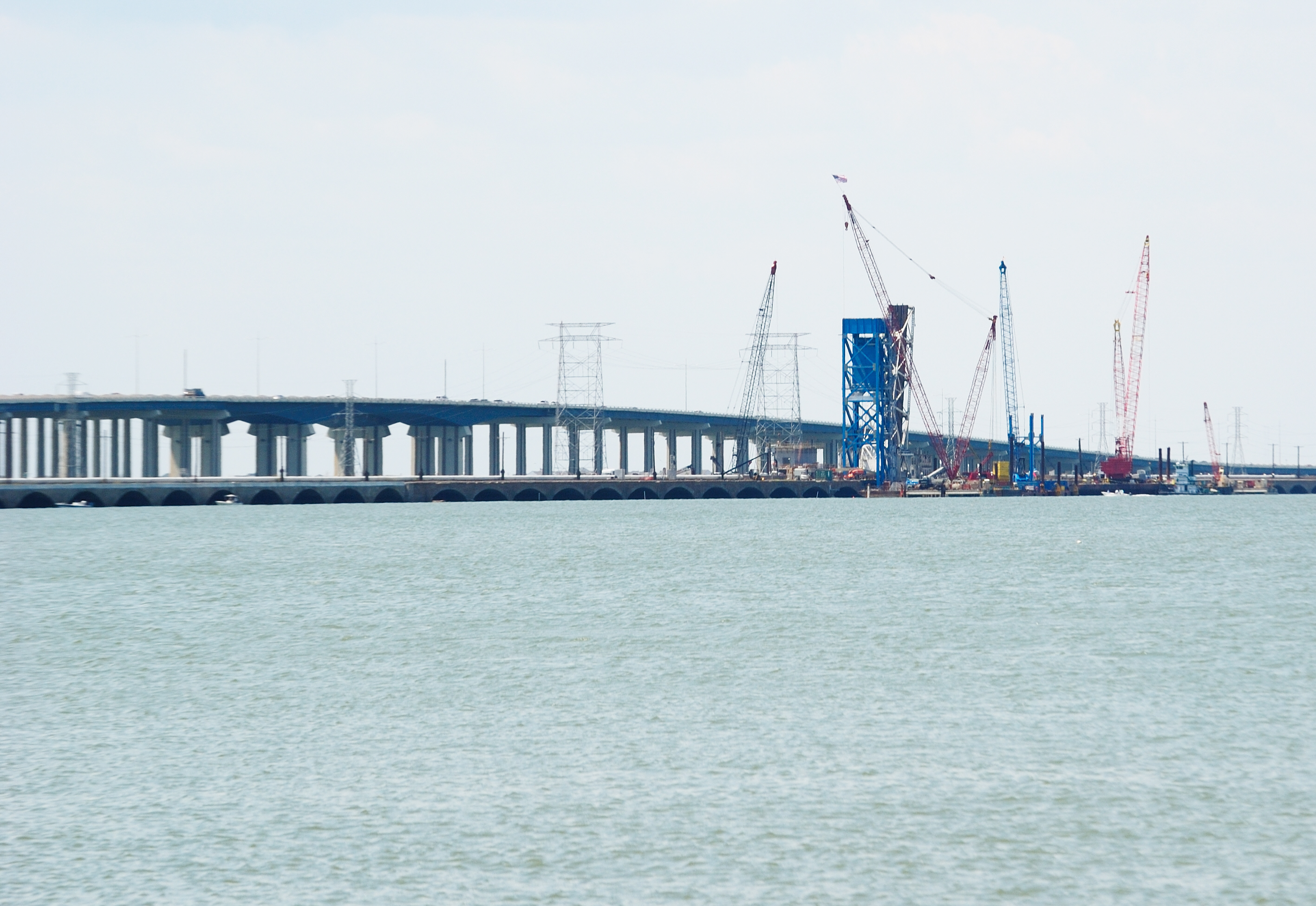
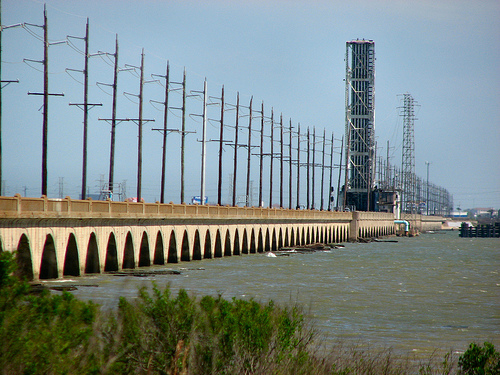
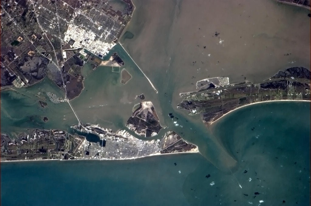
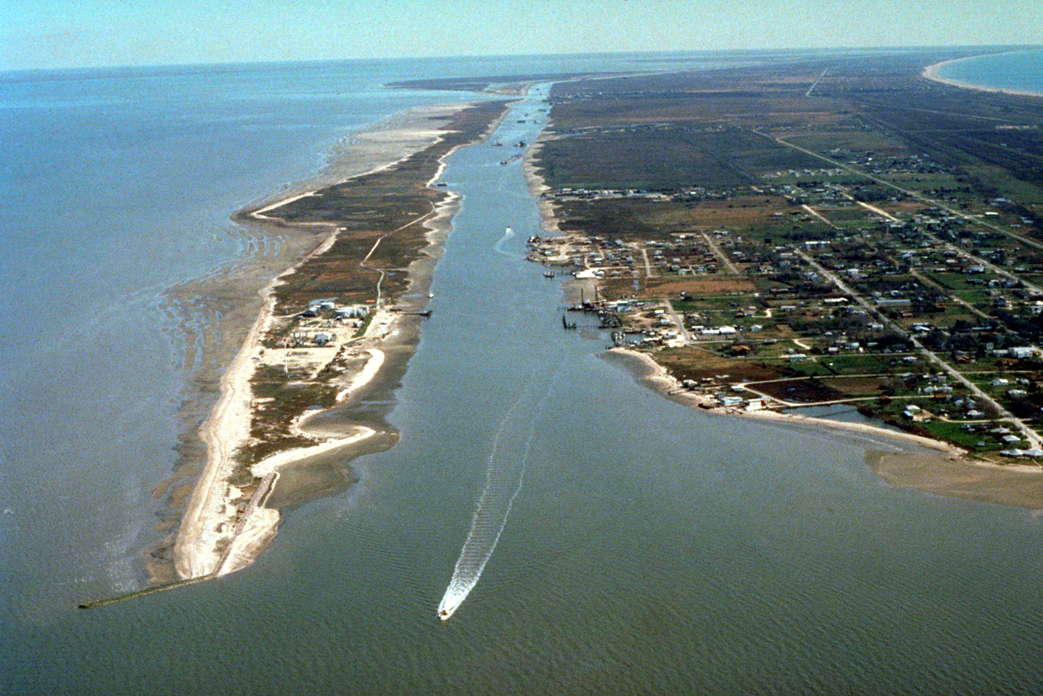
| | | | At this closer range, at the Gulf, review Galveston Island and Port Bolivar. Between Pelican Island and downtown Galveston is the port, where cruise ships now stop. Also notice how Pelican Island is the closest point to the Bolivar Peninsula (more later). Then inspect both I-45 and the secondary route through Texas City. Both merge to cross over the Galveston Causeway (Photo by Patrick Feller). But if I left it at that, I'd be telling a half-lie, and you wouldn't be understanding this picture. There are TWO causeways involving THREE crossings, and they provide the only land access to the island. In this view looking out from Galveston, the higher causeway in the background consists of two separate spans, one for each direction, which today are the only road connection. They were completed in 2006 and 2008. The pair replaced the second road bridge from 1939. | | | | But it's the lower causeway in the foreground that's the star of the show, including the lifting section in blue replaced in 2012. I was able to look down from the roadway and noticed it at the time, and have since read further about it. It was built in 1912 and is on the National Register of Historic Places. It originally carried both a roadway and rail line before the roadway was moved to its own bridge, so now it's just a railroad causeway (Photo by Nsaum75), used today, unfortunately just for freight traffic (more later). | | | | Galveston The somewhat remote location from today's point of view belies the importance of Galveston in the past. French explorer LaSalle in 1684 named the island Saint Louis. To this day, the strait at the western end of the 51 km (32 mi) island is still called, partly from the Spanish version, San Luis Pass. As a barrier island, it's only about 3 km (2 mi) wide at best. In the 1780s, a Spanish military settlement on the island was named Gálvez in honor of Bernardo de Gálvez, the Commander General of Louisiana (do remember that this area was Spanish when the French sold it out from under them). Gálvez later rose to the position of Viceroy of New Spain. The bay was called Gálvez Bay.
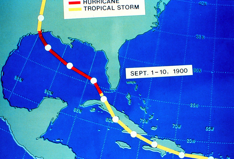
| | | | I have found some idiotic statements online that the Spanish were the ones that altered the name from Gálvez to Galveston, when it's obvious that the suffix –ton is a short form of the English word "town". It would instead seem far more likely that, once the area was under the influence of the English language—perhaps under the Texians—Galvez Town had to be distinguished from Galvez Bay, since they had the same name, and the former developed into "Galveston". As an interesting additional development, Galvez Bay is now called Galveston Bay. Think about it. | | | | The first European settlements came in about 1816. The natural harbor has historically provided the best port site between New Orleans and Veracruz, and it developed into one of the busiest seaports in the US, particularly capitalizing on Texas's rapid rise in the cotton trade. Galveston became important enough that it served as capital of the Republic of Texas. In the mid-to-late 19C Galveston became the largest city in Texas and its business district, the Strand, became known as the "Wall Street of the South", and Galveston became the richest city in Texas. It was also the cultural center of Texas. At the turn of the 20C, Galveston was second only to Ellis Island as an immigrant entry point. | | | | Into the 20C it became a summer getaway, known for its beaches. By the time the Roaring Twenties came around, it became a popular resort, with an illegal, though widespread, sex trade and gambling. It attracted many celebrities from around the country, and seems reminiscent in many ways of Las Vegas today. It was a high point in Galveston's economy and prosperity. But then troubles plagued the city. After the 1900 hurricane, the port was rebuilt quickly, and by 1912, Galveston was the second-leading exporter in the US, after New York. But after the 1915 hurricane, people became wary of investing in Galveston. The opening of the Houston Ship Channel in 1915 allowed Houston, Texas City, and other locations to begin to surpass Galveston as leading ports and commercial centers. As an obvious indicator of change, by 1930, map makers were showing Houston, and not Galveston, as the major city on the Texas coast. | | | | The 1900 Galveston Hurricane One of the main things that attracted me to Galveston were the stories of one of the most disastrous and famous hurricanes in recorded history, and its aftermath. Dating to before hurricanes were given peoples' names, it's usually just referred to as the 1900 Galveston Hurricane, with a round-number date that's easy to remember. With all their prosperity, Galvestonians had become very complacent. Despite what had happened to Indianola, Galveston had easily survived numerous storms, and people believed any future storms would be no worse than previous ones. Calls for a seawall were disregarded. Ironically, sand dunes along the shore were cut down to fill low spots in town, removing what little barrier there was to the potential invasion of the Gulf of Mexico.
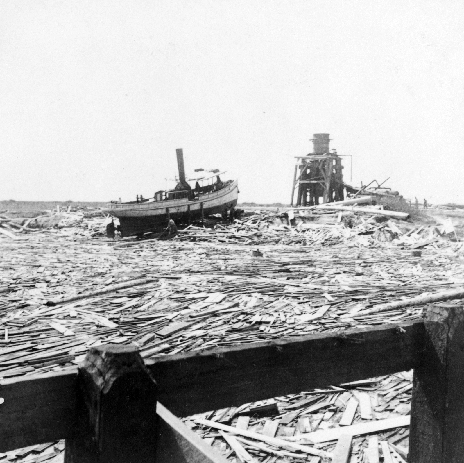
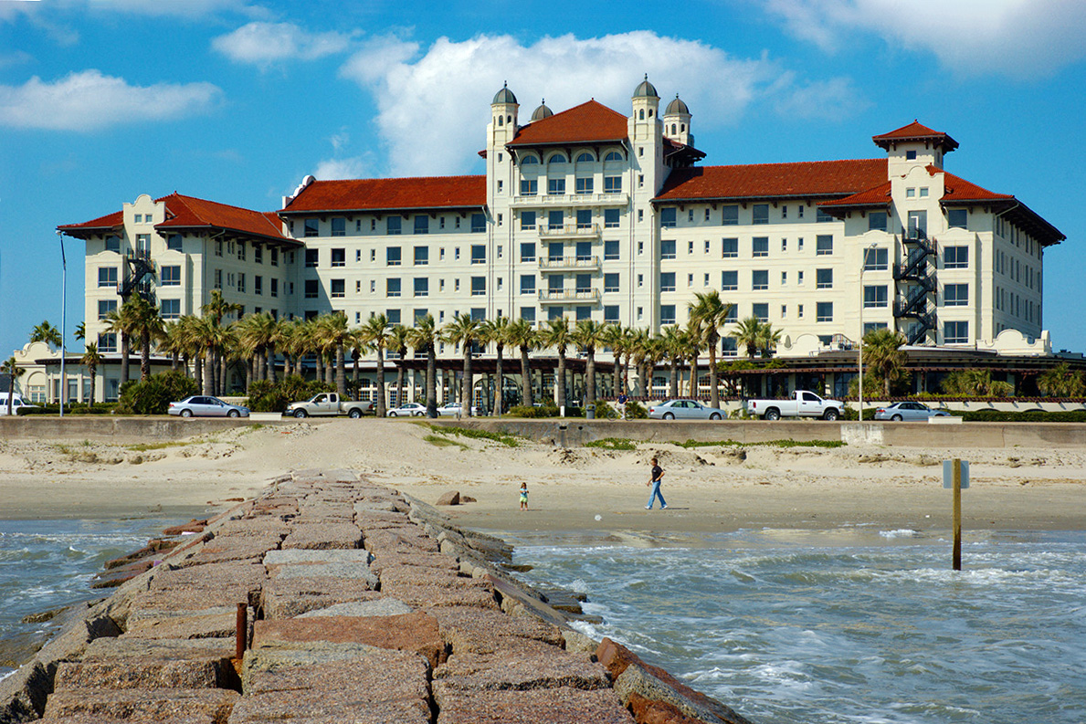
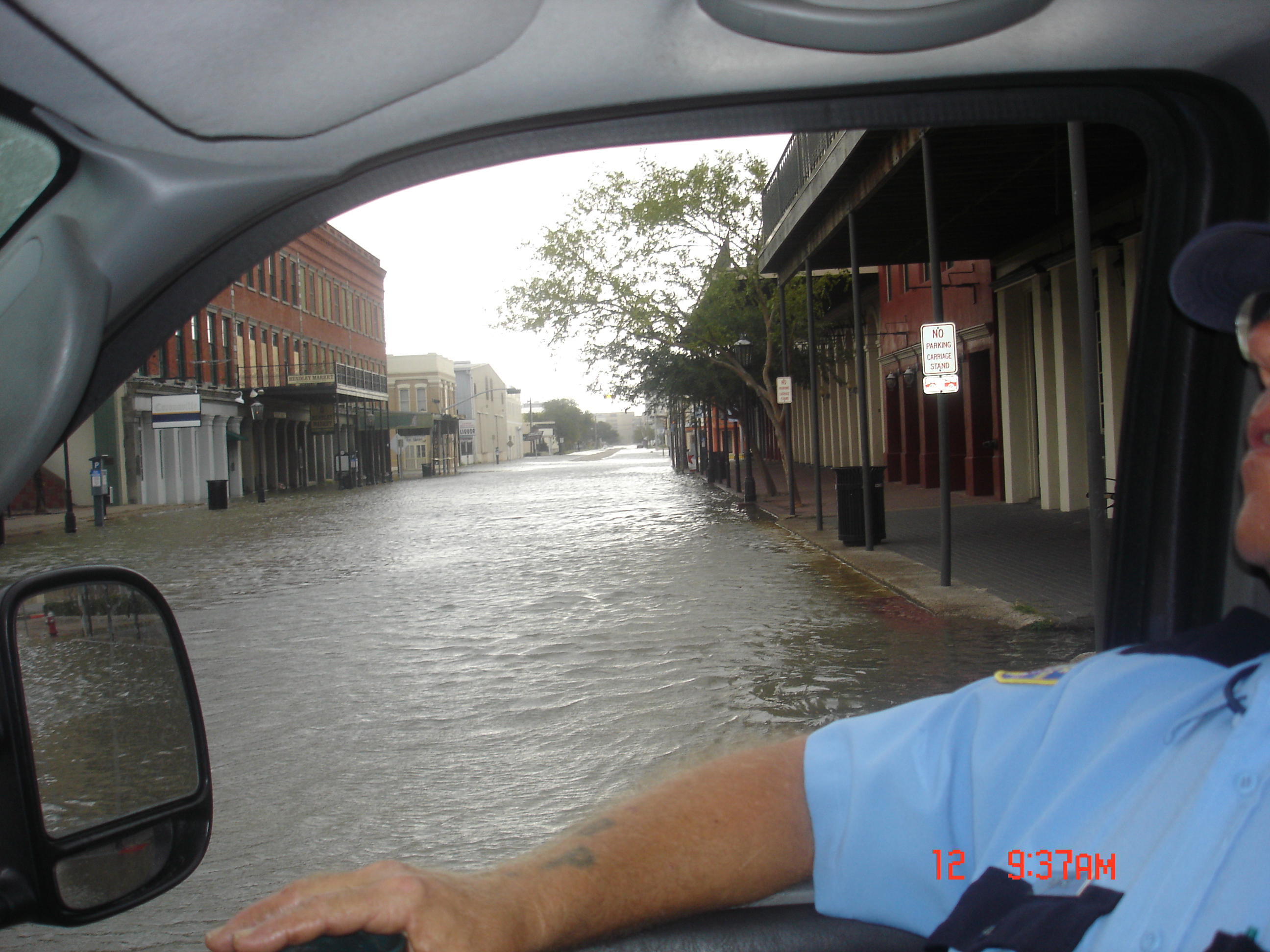
| | | | It was an unparalleled disaster, killing thousands and destroying 1/3 of Galveston when it struck on 8 September that year. This is the route it took. It had estimated winds of 233 km/h (145 mph), making it a Category 4 (5 is the very worst). I was curious about definitions, so I referred to the website of the National Hurricane Center. By the definition of a Category 4 hurricane, well-built framed homes can lose most of the roof and/or exterior walls. Most trees will be snapped or uprooted and power lines downed, which will isolate residential areas. Power outages could last weeks to months, and most of the area will be uninhabitable for that same period of time. | | | | I also heard various numbers as to just which hurricanes were the deadliest and costliest, so again I went to an original source. In a 2011 report from the National Hurricane Center (http://www.nhc.noaa.gov/pdf/nws-nhc-6.pdf), Table 2 listed Mainland US tropical cyclones causing 25 or greater deaths, from 1851-2010. It ranks as #1 the 1900 Galveston Hurricane (Cat 4) with 8,000 dead, with a footnote saying it could be up to 12,000. [It is also considered to be the greatest natural disaster of any sort to ever hit the United States.] #2 was a 1926 Florida storm (Cat 4) with 2,500 (could be 3,000), and #3 Katrina in New Orleans in 2005 (Cat 3) with 1200. The list of 52 storms drops quickly into the hundreds, then tens. | | | | As to the costliest storm, Table 3a is not adjusted for inflation, so all the storms listed are from the last few decades, which isn't helpful. The first part of 3b ranks storms by the inflation of 2010 dollars, and yields as the first three of the costliest, Katrina, Andrew (Florida, 1992) and Ike (2008, which also hit Galveston), but this, too, isn't as helpful. It's the second part of 3b that gets the most interesting, because it skews the numbers not only by 2010 dollars, but also by the population of coastal counties, as well as changes in personal wealth. The results are strikingly different. The #1 costliest storm was the 1926 Florida storm above (C4), in adjusted dollars at about $165 billion, #2 was Katrina, 2005 (C3) at $113 billion, #3 was Galveston 1900 (C4) at $104 billion, and #4 was Galveston 1915, a follow-up C4 storm at $71 billion. To complete the list with Galveston's third big storm, #9 was Ike in 2008(C2) at $30 billion. | | | | In 1900, the highest point in low-lying Galveston was only 2.7 m (8.7 ft) above sea level, and the hurricane brought with it a storm surge of over 4.6 m (15 ft), which ran over the entire island. It knocked buildings off their foundations and the surf pounded them to pieces. Over 3,600 homes were destroyed. After this picture was taken, 80 bodies were found in the wreckage. Many in Galveston had to be buried at sea. There was a wall of debris facing the Gulf, and there was floating wreckage--flotsam—everywhere, this picture showing the bay near Texas City. The few buildings that survived were mostly solidly built mansions, and the stone commercial buildings along the Strand. This is a Galveston Storm Marker (Photo by Katefan0) on the Strand put up on the centennial of the storm on those buildings that survived it. | | | | In addition to these photographs, there is some interesting film footage shot. This clip is one of several that are interesting on the topic, not only as an early news report, but because of who made it. The story was of enough importance that Thomas Edison sent a crew to Galveston to film the aftermath. The storm was on 9 September, and the crew shot this footage on the 24th. It is rare to see newsfilm footage dating from as early as 1900 as in this 0:46 YouTube video of searching the ruins on Broadway, Galveston. | | | | A Unique Solution There had been earlier calls to build a seawall in Galveston, but now they would no longer go unheeded. Just as rivers, notably the Mississippi, have levees to protect areas from floods, this seawall was to function as a barrier in the same way. Construction of a seawall on the inland side of the beaches began just two years later, in September 1902, and the first 5.3 km (3.3 mi) segment was ready in the summer of 1904. Then concentrated work was done for about another 6-8 years. From 1904 until 1963, the seawall was extended to its present 16.7 km (10.4 mi), which is one-third of the island's Gulf frontage. It starts at the very east end of the island, at the Galveston Channel, and therefore covers a most of the built-up area of the city. This period picture shows the seawall under construction. The base is 4.9 m (16 ft) thick and the wall is about 5.2 m (17 ft) high. The curved part faces the beach and the Gulf. | | | | But how about that straight part? Does the back of the seawall form a wall blocking the view of the Gulf? That's certainly true about most levees. THAT is where the Galveston solution was so unique and so dramatic. Because of the height of the seawall, to "level the playing field", the level of the entire city was raised. Sand was dredged to raise the height of Galveston, but also to make it into a slope. At and behind the seawall, the ground level was raised the same height as the seawall, 5.2 m (17 ft), but that sloped down to the bay side near the Strand, where it was raised by about 2.4 m (8 ft). Because of this slope, any water in the streets would run downhill into the bay. Over 2,100 buildings were raised in the process, including the massive, stone St Patrick's church. This entire engineering feat was so successful that when that second, similar hurricane hit Galveston in 1915 with a storm surge of 4 m (12 ft), that was less than the height of the seawall and the city was safe and there were very few fatalities. The seawall was listed in the National Register of Historic Places in 1977, and the building the seawall and raising the island were jointly named a National Historical Civil Engineering Landmark by the American Society of Civil Engineers in 2001. The street that runs along the top of the seawall is Seawall Boulevard, a nice seaside drive. The sidewalk adjacent to it is claimed to be the longest continuous sidewalk in the world at 16.6 km (10.3 mi). | | | | Immediately after the 1900 hurricane, Galveston worked to bring itself back. In 1911, the luxury Hotel Galvez
opened on Seawall Boulevard. It is still there (Photo by wools). Click to inspect the beach, seawall, and Seawall Boulevard. Hotel Galvez is on the National Register of Historic Places, and participates in the Historic Hotels of America program, the official program of the National Trust for Historic Preservation.
| | | | While the Hotel Galvez is still with us, another improvement that opened in the same year, 1911, is not. It was the Galveston-Houston Electric Railway, which became the fastest interurban system in the US. Interurbans were electric railways similar to light rail, or streetcars. They were extremely prevalent in North America between 1900 and 1925. As the name implies, they went primarily between cities and towns; unlike railroads, they were completely passenger-oriented. With most roads still unpaved making carriage or auto traffic more cumbersome, they were a fast, convenient mode of transportation. In 1915, there were 24,900 km (15,500 mi) of interurbans operating in the US, and for a while, interurbans were the fifth-largest industry in the US. Yet by 1930, most were gone. They paid taxes on their route system and roads for automobiles were publicly subsidized. Few remain today. | | | | In any case, the Galveston-Houston Electric Railway existed from 1911 to 1936. In the years 1925 and 1026, it was recognized as the fastest urban railway in the US, covering the 80 km (50 mi) between the cities in as little as 75 minutes. It roughly followed the route of I-45, but of course, on the older 1912 causeway, which was considered a great feat of engineering. Part of it today is used as a utility right-of-way for high-tension power lines. Do copy and paste this link:
http://upload.wikimedia.org/wikipedia/commons/c/cd/HouGalvCauseway19130.png
| | | | The illustration shows the 1912 Galveston Causeway being used by both rail traffic and an interurban—the difference is obvious. Then copy and paste this link:
http://upload.wikimedia.org/wikipedia/commons/5/5a/HouGalvCauseway1913.png
| | | | And here we see both trains and period automobile traffic. Both illustrations are dated 1913 and are apparently from a book entitled "Houston: Where Seventeen Railroads Meet the Sea", an intriguing title, since all passenger rail traffic, interurban and standard, is now gone from the area. But there has been talk of reestablishing some form of passenger train service between the cities, which seems particularly desirable given their close proximity. The old interurban right of way could perhaps be used, particularly to bypass the current freight traffic. | | | | As to the seawall, after Hurricane Alicia in 1983, the Corps of Engineers reported that the seawall had avoided $100 million in damage. But then Galveston's third modern hurricane struck, Hurricane Ike in 2008 (13 September), and large waves swept right over the seawall. There was a mandatory evacuation of the island, although up to 40% of the residents may have stayed there. There were storm surges of up to 6.1 m (20 ft), which is higher than the seawall, and the worst happened again. Sometimes even having a house on stilts doesn't do that much good. Widespread flooding included downtown Galveston; for instance, the courthouse took in 2 m (6 ft) of water. This is a view of the Strand after Ike (Photo by Grynslvr2). | | | | The Bolivar Peninsula, which of course had no seawall, was covered by 3.7 m (12 ft) of water. Media estimates of lost homes there were between 80% and 95%. Many who did not evacuate remained unaccounted for. | | | | Our Arrival in Galveston Those of us that have always lived on the seaside take the ocean for granted and find it hard to understand the plight of inlanders who often have make it an overnight trip to get to the sea. As kids, we'd be taken to Coney Island or Rockaway at the drop of a hat. I've also taken the subway to the sea, including a few times recently. So when I mentioned to the driver who picked me up in San Antonio to go get the car at the Enterprise office that one of the places I was going to was Galveston, she brightened up immediately and started telling me how over the years they'd take beach trips out to Galveston. In other words, Galveston was a distant Oz, a beach that happened to have a city attached. When I told her that my hotel happened to be on the beach (it was too late for beach visits, anyway), but that I was there to see the seawall and the historic part of town, she admitted she never knew there WAS a historic part of town. I'll tell later a similar occurrence that happened in Mississippi, just to show we all have different reasons to travel, and don't necessarily appreciate—or anticipate--the reasons of others. Anyway, the larger-scale of the two maps that will guide us around town will be this one. Copy and paste the link, and keep it handy until we leave town:
http://www.galveston.com/maps/GalvestonMap_010614.pdf
| | | | We come across the causeway and look at the older one next to it (not shown). We also find that having driven I-45 for its entire length from Dallas, it ends by becoming an attractive central boulevard named Broadway. Actually, like many cities not happy with a single word name like that, it's called Broadway Avenue--also known as Avenue J, since most east-west routes are lettered avenues and north-south routes are numbered streets. We also spot Pelican Island—the port lies between it and downtown Galveston—and the ferry to the Bolivar Peninsula. And then we spot our two goals, the beach, seawall, and Seawall Boulevard on the Gulf, and downtown, where the concentration of numbers is. But then we need the smaller-scale map for the finer points, so now copy and paste this link and also keep it handy:
http://www.galveston-captain.com/images/placesmap.jpg
| | | | The numbered streets do start at 1st Street in the east and peter out in the central area in the 50's, although there are a few 70's and 80's as well in the distant western area. But the only numbers you need to remember are all in the low 20's, from 20th to 25th Streets, with the latter being the most important of the group. These are the five blocks of the historic Strand downtown, and that's also the stretch of Seawall Boulevard we'll stop at first. But before that, let's check out the lettered avenues. They start with Avenue A at the port, and the highest I find is Avenue U, but because the grid at this end follows the tapering island, our stretch of five blocks ends at Avenue Q. Well, actually, at the oddly-named Avenue Q ½. But as it turns out, many of the downtown avenues have acquired other names, from Avenue J-cum-Broadway Avenue on in. Harborside Drive is rarely Avenue A, and the Strand is "never" Avenue B. | | | | It's obvious that it's a simple right off Broadway Avenue onto 25th Street that will get us to the Gulf. I'd looked for a b&b when planning, but the one I wanted was already booked months in advance, so, since I could get a modest place on the beach free on points, that was the way to go. Yet I was surprised at the end of 25th when I was waiting at a light to turn left onto Seawall when I spotted a huge amusement pier, visible on our smaller map. It was like the Steel Pier in Atlantic City or the Santa Monica Pier, full of rides and other attractions. It wasn't what I'd wanted in my line of sight when looking out at the Gulf, but so be it. The modest Four Points by Sheraton was two blocks in, on Seawall at 23rd. It was adequate, but unfortunately was perpendicular to the Gulf, so most windows faced sideways. I faced both the parking lot and the amusement pier, but I really didn't need look out the window much. By the way, the Hotel Galvez was steps away at 20th. | | | | After the visit to Dallas and the long drive, it wasn't worth trying to do much other than to walk across Seawall Boulevard to look at the seawall, beach, and Gulf. I wasn't aware originally, and only understood later, why there was a dropoff to the beach without having noticed any rise in driving here—it's because the whole town had been raised! What an unusual feeling. There were two huge, informative granite historical markers right across from the hotel that told about the engineering project. I have a picture including the markers (Photo by Texasbubba) that tells more of a story than at first glance. | | | | First click to enlarge to read what you can of the markers. But this is not the current view that I saw. This picture was taken in 2008, right after Hurricane Ike. So as you look down to the beach level, you see hurricane debris, and in the Gulf, the ruined building that stilts didn't help. But then take another look at the markers. You can tell that each one consists of three parts, stacked on top of each other, and that the middle section is just a bit off center from the base, but that the uppermost part has been substantially pushed askew by the storm surge coming over the seawall. This has all been repaired, but this photo carries with it a symbolic connection between the storms of 1900 and 2008. | | | | Our Full Day in Galveston It's a new day and we have it all to spend in Galveston before leaving Texas tomorrow. Since there are significant buildings in several historic districts, let's start with them. It's easiest to go into town on broad 25th Street, which has the additional advantage of being the border to the Silk Stocking Historic District (in pale blue on our smaller-scale map). We can check out 24th and the side streets, but a special prize is just outside this district, so we stay on 24th and cross Broadway and come across Ashton Villa, the star on our map and #2. Copy and paste this link for it:
http://upload.wikimedia.org/wikipedia/commons/3/3c/Ashton_Villa_Galveston_Texas.jpg
| | | | This Victorian Italianate dates from c 1859. Because it was sturdily built with thick brick walls, Ashton Villa withstood the 1900 hurricane. It's gorgeous, but does something strike you odd? Maybe it looks a little low? With the grade raising of the city, its basement was filled in with sand, and its grounds were topped with 0.6 m (2 ft) of soil. In other words, it looks a little low because it's slightly buried! Yet during Ike, it took in about 0.5 m (1.5 ft) of water, and required further restoration. It's on the National Register of Historic Places. | | | | Continuing east on Broadway we can enter the Lost Bayou Historic District (darkest blue on map). This was where the unavailable b&b was that I was considering. Much of the area between 20th & 23rd, and between Avenue L & the Gulf had been covered by a small stream called Hitchcock's Bayou, which was "lost" when the grade level was raised. The 1900 storm is always current in Galveston. | | | | On the left side of Broadway, in medium blue, is the East End Historic District, the largest. Copy and paste:
http://upload.wikimedia.org/wikipedia/commons/b/bc/Trube_Castle%2C_Galveston.jpg
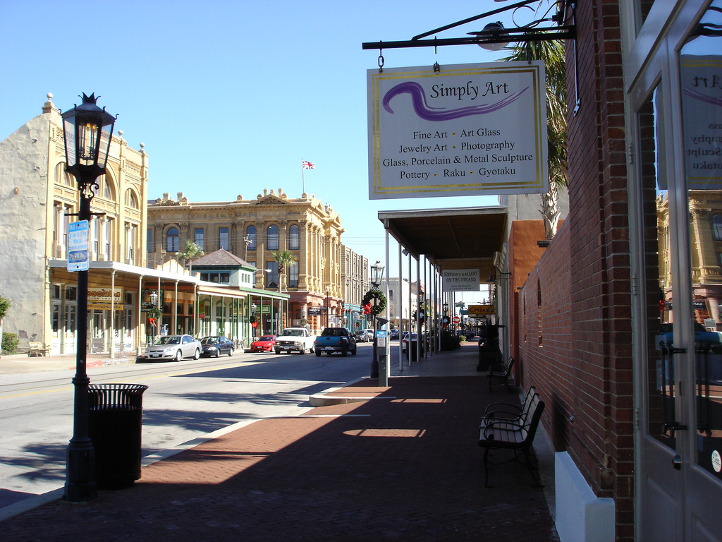
| | | | This is the absolutely dreamy 1890 Trube Castle, with its unique corner stoop. Click to read the original family's name on the bottom step. But the most famous mansion in the district, probably in town, is the ornate Bishop's Palace (Photo by Rwminix), right on Broadway at 14th, #3 on the map. It was built between 1887 and 1893. The American Institute of Architects has listed it as one of the hundred most significant buildings in the US, and the Library of Congress has classified it as one of the fourteen most representative Victorian structures in the US. Sturdily built of stone, it withstood the 1900 hurricane, and the family that built and owned it welcomed hundreds of survivors into their home. In 1923 the Catholic Church bought the house, located opposite a church, as the residence of the local bishop, hence the current nickname. It is now open to the public for tours. Be sure to click to inspect the details. | | | | We now go to the five-block Strand Historic District. Online advice was to start at the Railroad Museum at the west end head of the Strand, on 25th Street, # 16 on the map, where parking is free and it's just a few steps into the district. | | | | The museum is in the former Santa Fe Union Station, sadly no longer in use for passenger service, such as we saw on the causeway pictures. On four tracks behind the station there are the standard railroad cars to review, period sleeping car bedrooms, pullmans, beds that slid out from underneath, private cars, and post-office sorting cars where mail was sorted en route. If there was a station that the train wasn't supposed to stop at, a mail bag was thrown off as the train sped through the station, and a hook from the post-office car swooped up a local mail bag from its station hook. | | | | This is the former Santa Fe Union Station (Photo by i_am_jim), with its front door on the right under the US and Texas (!!) flags, facing east down the Strand. The close part dates from 1913 and in 1932 the tower and right wing were added. At first I didn't care for the building, but then I noticed the beautiful Art Deco decoration in the tower, and it won me over. It just doesn't look like a railroad station (the tracks are on the extreme left)—which it was—but it was also meant as an office building—which it does look like—to house the general offices of the Santa Fe Railroad's Gulf Lines. In 1964 the rail office closed, and in 1967 the last trains departed. The offices are now commercial offices and the rest is the railroad museum. | | | | But for me, the best was inside this unusual rail museum. Not only does the building look like the office building that it is and was, the waiting room for the station looks much more like a hotel lobby than what it is. And when you enter those front doors, this is the waiting room that you see (Photo by Bill Olen). It STILL looks more like a lobby than what it is/was, but what the museum has done to evoke the period is unique. While that newsstand in the back is real, selling snacks and papers, the rest is a work of art, evidently called The Waiting Room, as that sign on the right says. As you walk in and turn around, you can better inspect the life-sized white plaster figures (Photo by i_am_jim) in period dress, accompanied by 1920s-1930s period music playing softly in the background. These are not department store mannequins, but works of art, ghost-like figures from the days when real travelers waited here for trains. Of course, I sat down next to one and participated in the tableau, although my presence alone didn't make it into a tableau vivant. On a wall there was a 1930 system map of the Atchison, Topeka, and Santa Fe railroad, which added to the sense of loss. There were the routes you'd expect, to San Francisco, Los Angeles, Denver, St Louis and Chicago, but then also the Gulf Lines I hadn't been aware of down to Dallas/Fort Worth, Houston, Galveston, and even a roundabout spur line that came down the Bolivar Peninsula from the far end, up to Port Bolivar opposite Galveston. | | | | Walking across the street, we're on The Strand itself. It's a National Historic Landmark District consisting mainly of Victorian commercial structures (Photo by Bill Olen), usually of brick or stone, that survived the storms, as opposed to the Victorian residences we've seen. They date from when the Strand was a major business district, but today they've been recycled as restaurants, antique stores, curio shops, art galleries, and the like. The two oldest buildings still standing on the Strand date to 1855 and 1858, and many others to the 1870s and 1880s. This corner building (Photo by Patrick Feller) is today Luigi's Italian Restaurant, but you can also see what it was in its former incarnation (Photo by WhisperToMe) , before it was recycled. | | | | As we've seen, the street is officially Avenue B and the reason for the change is interesting. In the heyday of the district, there was a jeweler who didn't think Avenue B was an elegant enough name for a prestigious district. He was familiar with the street in London called the Strand and decided to start using that name on his stationary. Later, neighbors followed the practice, and so the much more familiar name for Avenue B came about. | | | | Walking along, I was interested to note a "1900 Storm Survivor" plaque on one building, which was at my height and was meant to show the water level reached. But then about half again higher was another mark labeled "Hurricane Ike High Water 9-13-08". | | | | As you can see from our map, there are a number of interesting sights a couple of blocks inland from the Strand, and, while not technically part of it, do add to the flavor. In particular, one is advised to walk down Post Office Street, also known as Avenue E. On it you will find, between 20th and 21st, what is billed as the Grand 1894 Opera House, #8 on the map. Copy and paste this link:
http://upload.wikimedia.org/wikipedia/commons/5/5f/1894_Grand_Opera_House_Galveston.jpg
| | | | Like the rail station, it doesn't look like what it is. It functions today as a not-for-profit performing arts theater. There's a long list of famous names who have appeared here, from which I'll just select a few. From the earliest period, Bernhardt, Paderewski, Pavlova, Sousa. From a middle period, the Marx Brothers, Burns & Allen. From a more contemporary period, Willie Nelson, Lisa Minelli. I found out recently that it was here that Holland Taylor performed her Ann Richards show when she was touring. In 1993 the venue was named "The Official Opera House of Texas" by the 73rd Texas Legislature. | | | | I've seen the building described as Romanesque Revival. Perhaps it is, inside, but as for the front entrance (Photo by Wiki name), if anything screamed Richardson Romanesque, this is it. This architect had to have been influenced by H H Richardson, because if there ever was a massive, curved stone arch, this is it! The arch at the top of the entry is so massive that there are no sides to the entry. The upper arch overwhelms the whole thing. I really like it. | | | | Let's walk up 22nd Street to get back to the Strand (Photo by Patrick Feller). 22nd is on the right in the picture, and Mechanic Street/Avenue C is in the foreground, so that's the Strand behind it. Click to see architectural details, and to confirm that we're seeing the Crown Princess in the background, and how these big ships overwhelm these smaller buildings. The day I was there, there were two ships in, the Navigator of the Seas (Photo by emijrp; taken in Cádiz) and the Carnival Magic (Photo by Sgt. 6202; actually taken in Galveston precisely 33 days before I saw it there—it's amazing what you can find online). It was a Sunday, and many ships cruise weekend-to-weekend, and traffic control near the wharf was trying to guide all the arriving cars. Galveston is the homeport, either year-round, or for part of the year, for a number of ships. | | | | Walking back down the Strand, we'll come across the place of my sad downfall, at 24th Street. Copy and paste this:
http://www.lakingsconfectionery.com/userimages/aboutpic1.jpg?rand=1114034507
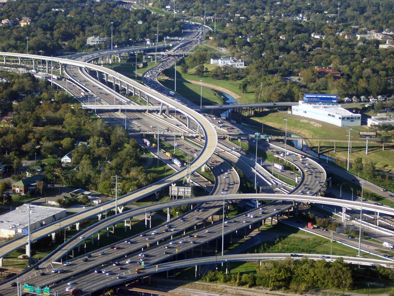
| | | | This innocuous-looking historic building houses La King's Confectionery. It's an old-fashioned, very large maker of homemade candy, particularly chocolates, and also makes ice cream and has a soda fountain. If you're there at the right time, and I was, the Candy Master makes taffy from start to finish in an open viewing area. One machine winds the taffy and a 95-year-old smaller one wraps the pieces. Every once in a while, he tosses a wrapped candy to someone in the crowd. I got lucky. Watch this 1:43 YouTube video of La King's Confectionery. He tosses a taffy at 0:40. | | | | Check out the size of the store, the candy counters, and the seating area. As I've stated in the past, I don't eat lunch when I travel, and don't snack. But my first downfall came as I started my walk. He tossed me a taffy, and I got the urge, so at the chocolates counter I bought a quarter-pound of something sinful, sat down at a table and gorged. But then at the end of the walk, I couldn't resist, and went back for a second downfall. However, this time, it was a quarter-pound of sugarless fudge, so it wasn't as bad. These are the little temptations of life. | | | | Finally, it's seawall time, and we drive back down 25th Street to the hotel area, but turn right onto Seawall Drive for a seaside excursion along the Gulf. Look at our large-scale map to see the route. | | | | Actual riverside or seaside drives are rare for any length, as views are often blocked, as we'll see driving along the Mississippi, so it's a pleasure to drive along the Gulf here. From the amusement pier at #19, the greater length of the drive is in this westward direction—and you can see the seawall represented on the map. We want to see where and how the seawall ends, and come eventually to a fork. We take the left fork leading in front of several apartment buildings, and finally Seawall Drive comes to an end with a dropoff ahead like the one we've had all along on our left. We turn around, go back to the fork, and take the other route. It's a very odd feeling to suddenly go down a slope, and find ourselves much lower behind the backs of those same apartment buildings. | | | | We turn around again and go back into town so we can see the east end. This 1:14 YouTube video shows what an Eastbound Ride along Seawall Drive looks like. You'll see early on the black handrails down to beach level, but only later can you judge your actual height above beach level. | | | | We then pass the amusement pier and Hotel Galvez, and find that Seawall Boulevard moves a bit inland and ends at Galveston Channel. The map shows that the seawall stops, but when I got out of the car at the channel, I know I was standing on some sort of a wall, so I can't be sure about that. There were a number of people there, and it was a pleasant spot to watch the water and ships in the 370 m (1,200 ft)-wide (at its narrowest point) channel. A right turn takes you along the East End Lagoon Nature Preserve (#2) to other good views at East Beach (#1). This is the view from the International Space Station. Through the Galveston Channel flows the commerce to the Port of Houston, the largest inland port in the US, as well as to Galveston and other communities around the Bay. About 7,000 ships a year visit Houston alone. | | | | It was at this point that an idea struck me. I had planned to leave the next day by backtracking over the causeway and taking that other road through Texas City, but wasn't happy about that. I knew there was a ferry, but had heard there could be long waits of up to two hours, and tomorrow's drive to Natchez would be the longest one of the trip, so I didn't want to chance it. Still, I drove over to the ferry terminal (#3) to see what it was all about. | | | | It's a free ferry, provided by the Texas Department of Transportation to connect the two parts of State Highway 87, just like the ferry in Tadoussac, Québec. But the better news was that the large parking lot had only a handful of cars in it. It was worth trying to leave via the ferry and Bolivar Peninsula, if for only to have another route to try. | | | | It's local growth that adds traffic for the ferry, but even more during the summer. This is also an evacuation problem, or providing emergency services, especially since the Bolivar Peninsula has few such services of its own, and no hospitals. A tunnel was out of the question, but a bridge was suggested, using Pelican Island to connect to Port Bolivar. However, the bridge project was cancelled. | | | | Bolivar Peninsula After breakfast on the travel day I hurried to the ferry, hoping rush hour would not be a problem. As I pulled into the large parking lot, it was empty, and the guy waved me right through, and straight ahead. I pulled right onto a ferry, which had maybe a couple of dozen vehicles on it. Once I parked I looked behind me to see about another 6-8 spaces available, but also to see the gate being closed. I was the last one to make this sailing. I'm just guessing it might have been another half hour until the next one—I hope not more—but on a long driving day, you don't need to lose another half hour.
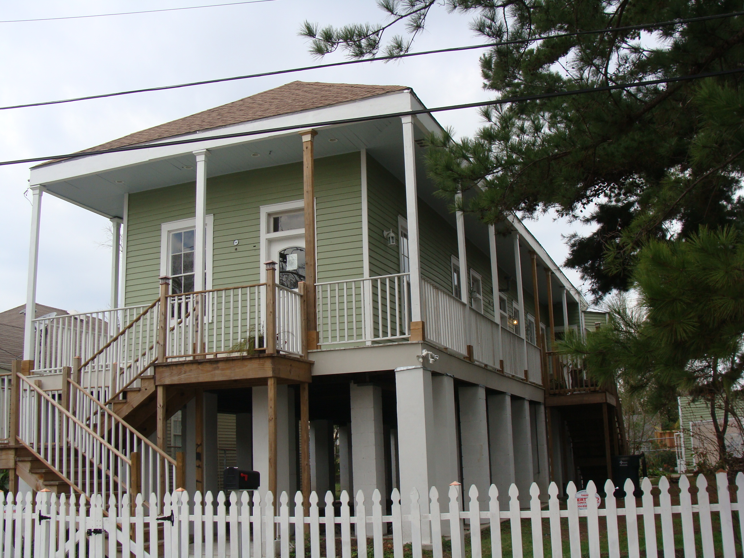
| | | | I walked around the main deck, then climbed the stairs up to the lounge area up top. The 4.3 km (2.7 mi) crossing to Port Bolivar was scheduled for 18 minutes, and it was time well spent. This short "ocean voyage" was invigorating, with good views from below and above. Behind us was Galveston, north was the bay with Houston in the distance, south was the channel to the open Gulf, and ahead was Port Bolivar. Watching just a bit of this 3:27 YouTube video of the Galveston-Bolivar Ferry should give an idea of the experience. | | | | The route ahead was both rural and quite simple. Instead of backtracking on TX-87 westbound to and over the causeway and then taking the route through Texas City to I-10, the ferry connects us to TX-87 eastbound to beyond the end of the bay, and then TX-124 will take us up to I-10 into Louisiana. This way we can try to get more water views. | | | | But as is usually the case, water views are only occasional. Sometimes we can see the bay for a bit, sometimes the Gulf, but that's the way it is when the road isn't a designated seaside promenade. Still, it's a quieter route than the alternative and gets us where we're going without backtracking. | | | | Over the years I've seen many stilt houses along the Gulf Coast, mostly in Florida, but also elsewhere. The need to protect a house from flooding while raising it is understandable, although it's usually less than fully successful in a hurricane. But they do look droll sometimes, like having a child's head on an outsized adult body. In a way they look a bit like giant spiders, all legs. Usually the area between the pilings is used as a carport, and for bulk storage, giving the look of an open-air garage underneath the house. I've also seen houses where the pilings we partially, or even fully walled in, probably with inexpensive plywood walls, that are easily replaced when necessary. Another alternative is to screen them in to make additional semi-outdoor living space. These houses then look like spiders in skirts! | | | | Driving on the Bolivar Peninsula there are lots of these houses, some in clusters. I saw a group of them that gave the impression of spiders at a tea party. Some of these are actually quite elegant (Photo by jc.winkler). These houses are on the Louisiana coast just ahead of us. Click to see how the area of the pilings can be utilized. And now I understand that since Katrina, there's more stilt house construction within New Orleans as well. This house (Photo by Karen Apricot), near the New Orleans neighborhood of Carrollton, was raised when rebuilt after Katrina. But as we've seen in earlier pictures, even the stilt technique can't always save the house.
| | | | Eventually the road turns left and becomes TX-124 going north. Suddenly it rises very steeply over a bridge, and it becomes clear that we're rising high to clear the Intracoastal Waterway. This gets me very curious, so I've done some post-trip research. The bridge here is the High Island Bridge, and what it's crossing is an Intracoastal Canal section of the Intracoastal Waterway. I never realized—or knew—how much of the Waterway is actually a canal, and I'm surprised that the Waterway does not go through Galveston Bay. Let's go back in distance a little with this picture. It looks east, the direction we're going. The Gulf is off to the right, and Galveston Bay is to the north, on the left. Towards the right is Port Bolivar, where the ferry dropped us off a while ago, off the picture. On the horizon toward the right is TX-87, that we just drove along on. As it turns out, the Waterway avoids the Bay on the left, and a special canal runs the length of the Bolivar Peninsula—and beyond—as part of the Gulf Intracoastal Waterway. While driving north, some of the views might have been of the Bay, but others were of this canal. I've found one more picture that shows a tug pushing barges (Photo by Patrick Feller) along the Bolivar Peninsula, giving the impression of boats passing through fields. I did not see anything like this, but did get to see this canal from the high bridge over it later on. | | | | Shortly after the bridge, we start noticing some bobbing heads. We're lucky enough that we're finally seeing some Texas oil wells even as we're about to leave Texas. The bobbing heads on both sides of the roadway as we drive by are officially called pumpjacks (Photo by Flcelloguy), and familiarly called nodding donkeys. They exist all around the world, but I'm glad we got to see some in Texas. This is a 0:18 YouTube video what a nodding donkey looks like as you drive by (although this one is actually elsewhere, along the Mississippi River). Curiosity got the better of me, so I found this 0:32 YouTube video animation that shows how it works underground to suck up the petroleum. | | | | Well, we're about to leave Texas for Louisiana on our way to Natchez, Mississippi tonight. Let's take another look at that earlier map to see how we leave. You see High Island, where we swung north over the canal and past the pumpjack area to meet I-10 and take it all the way to Baton Rouge. We'll pass near Port Arthur, but go through Beaumont, Texas. East of that is the Sabine River (like "marine"!!) where, as we now know from our Texas history, and confirmed on our large Texas map, we depart Texas for parts east. | | | |
| |
|
|
|

