|
Reflections 2014
Series 6
May 20
China XIV: Beijing I
| | We had visited the factory at Sifang in Qingdao on Day 9 and then boarded the train to Beijing. Copy and paste this link in another window for a rather good rail map to follow the route:
http://www.johomaps.com/as/china/chinarail.html
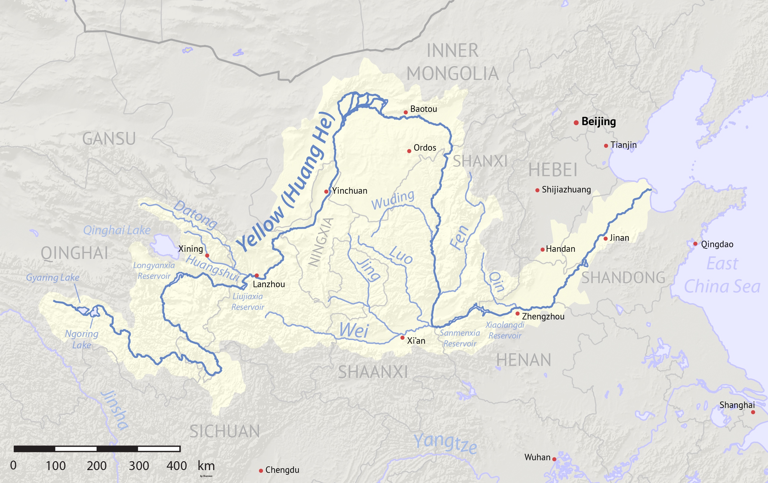
| | | | I knew (possibly as the only one) that we'd be crossing the Yellow River (Map by Shannon) en route, I see only now probably at Jinan (compare both maps), but it was pitch-black darkness outside the train, so not only didn't I see it, I didn't know when we crossed it. Later, leaving Beijing to the west for Tibet, we crossed it at night again, and when in Xi'an, I didn't see even the local river, let alone the Yellow River itself some distance to the east. | | | | Beijing We arrived in the early evening at Beijingnan (Photo by Max Farrell). Beijing South Station is new (2008) and is the largest in Beijing and one of the largest in Asia, blah, blah, blah. We didn't stop to look around, and it was dark anyway, so I cannot comment about its appearance in the picture. I read now it was designed by a British firm in collaboration with a local one. It's apparently of architectural importance, but we were just whisked to our waiting tour bus. What do you think we were, a special rail tour group or something? This is the station that was the final stop of the train we took out of Guangzhou, but got off of in Wuhan to go to Nanjing. | | | | Take a look at the Beijing Metro and rail map at this link:
http://www.johomaps.com/as/china/beijing/beijingmetro.html
| | | | Get a first impression of the layout of Beijing. That light blue rectangle adjacent to some lakes in the very center is the historic Forbidden City, around which all geography centers. Immediately to its south is that blasted Tian'anmen Square, about which I'll have a great deal to say shortly. You can also take preliminary note where the Temple of Heaven is located. | | | | There are five rail stations of varying importance in Beijing. Look to the east to find Beijingdong, which has a lot of freight traffic and only a few passenger trains. On the north(west) side of the city center, Beijingbei is also small and serves passengers going north
and northwest. As it turns out, the three stations we had occasion to use are the three big hub stations in Beijing and are all on the south side. The main Beijing Station to the southeast we used later to go to Tangshan on what I now see is the Jingqin Line. To the (south)west is Beijingxi, which seven of us used later for Tibet. But as you see, Beijingnan is in the south center, and is where we arrived. The yellow lines shows the two stations that have high-speed service.
| | | | The light white circular lines are the many ring roads Beijing has, which we'll discuss shortly on a map that shows them better, when I'll explain why I have an issue with the Second Ring Road, and its Metro line. You can see how the Metro lines and the ring roads indicate the historic center and the Forbidden City, simply by encircling it. You can see that the major stations, including Beijingnan, are well integrated into the Metro system, which we never got to use. Instead, we were schlepped by the tour bus through the elephantine boulevards of the capital to our hotel. | | | | Now if I had been on my own, I would have done the same sort of thing I'd described in Nanjing, taken the Metro from the station to the hotel. Follow on the map. We'd take the light blue line four stops north, the red line four stops east, and the purple line one stop north to Dengshikou. Google Maps tells me it's then a two-minute, 160-meter/yard walk east to the hotel. You can find for yourself how we could have planned to leave, several days later, by Metro to Beijing West for Tibet. But, so be it. | | | | Beijing, whose population in 2012 was 20,693,000, is China's second city in population after Shanghai. It's history goes back three millennia. It's had several names, and one old one that one still sometimes comes across is Beiping, or Northern Peace. We've mentioned in the past that its current name means "Northern Capital" in contrast to Nanjing, or "Southern Capital". While we know that the J in Beijing should be one of the CH sounds, in English it has two possibilities in free variation, either the French J (ZH) as in "déja vu" or the English J as in "jam". This variation is consistent with the two American pronunciations of "garage". | | | | While Beijing is the current, modern version of the present name in English, old versions, such as Pekin or Peking remain as fossils in set expressions in English, and do not get updated. The dog is a Pekinese, also Pekingese, but not Beijingese, and the delicacy is Peking Duck, not Pekin Duck or Beijing Duck. However, a little quick research shows that other common languages have not necessarily updated the name to the pinyin Beijing as English has. French still uses Pékin, Spanish Pekín, Portuguese Pequim, Italian Pechino, Russian Пекин / Pekin, Dutch, Swedish & German vary between Peking/Beijing. | | | | Destroying Signs of the Past: What's Missing? Most of us have major political issues with the current Chinese government as to democracy, human rights, and censorship, but we'll keep that as a separate matter. But I've indicated that I have cultural issues with Beijing as it's been altered by the present regime. I said early on in the China postings that, while I was looking forward to Shanghai, and happily give it the same three stars Frommer does, I knock down Frommer's three stars for Beijing to my personal two stars. Frommer has to give it three because no one should miss it—and I agree—but while I was in Beijing I was satisfied, and enjoyed many things about it, but was not ecstatic, as I knew I would be when I was in Shanghai. | | | | My issues can be summed up by references I've made to the Second Ring Road and its Metro line, the "elephantine boulevards", and "that blasted Tian'anmen Square", and are listed under the present rubric "Destroying Signs of the Past". We know that physical traces of the past get destroyed all the time through war, uprising, and sometimes willful destruction, but we don't expect as much of the latter in modern times, when we're much more aware of historic preservation. And oddly, I'm NOT referring to the Cultural Revolution, which is a situation unto itself, and a special case. I'm talking about willful destruction that was perpetrated in the 1950's by the present regime, who wanted to show its muscle, and where Mao wanted to put his personal imprint on the city. Fortunately, though, historic preservation seems to be high once again on the current regime's list, as we've indicated in discussions of other cities. | | | | I was first put on to the problems when the Frommer book said that events of recent decades have damaged Beijing more than at any time since the 14C. It said (Frommer's China, 2012, pp 59-60): Particularly severe was the ruin that took place in the decade after the Communist victory in 1949, when Mao, in a desire to put the stamp of his own dynasty on Beijing, leveled the city walls and the Imperial Way and paved over both. . . . Swaths of hutong have been leveled to make way for office towers. You may remember when we mentioned in Shanghai that hutong are the back lanes, mostly residential, on a human, not vehicular scale, that Beijing has been known for. It also said on p 64 that The city center . . . was originally surrounded by a complex of walls and gates destroyed in 1958 to make way for the Second Ring Road (Er Huan). Perhaps this bothers me more than it bothers you, but the hutong continue to disappear as Beijing is modernized and the monumental Ming relics mentioned are now mostly gone for good. Much of the modern architecture is admired, but the price being paid in the removal of the old lanes is questionable. Too much Old is being lost in quest of the New. | | | | We'll discuss the loss of hutong shortly. We'll discuss the loss of the Imperial Way when we talk about Tian'anmen Square. We'll start with the lamentable loss of much of Beijing's city wall system. | | | | Beijing City Walls Understanding just what walls were torn down can be confusing. You know the term "Forbidden City", but you also need to know the terms "Imperial City", "Inner City", and "Outer City". It's not complicated, but even when I was there I wasn't totally sure of the distinctions. Once again, I learn so much more post-trip. We've seen that the historic city, which once was the entire city, is in the center of modern Beijing, so let's take a look at it. Here's the historic city (Map by kallgan), and if you want to save it in a separate window for reference, here's the link:
http://upload.wikimedia.org/wikipedia/commons/f/fb/Beijing_city_wall_map.jpg | | | | It all starts with the INNER CITY, which is the equivalent of any walled city anywhere else. It's where the people lived, and were protected by city walls. Beijing's Inner City started as the remnant of earlier constructions, which were then added on to in the late 1300s and early 1400s. If you remember that men is "gate", you can review the names of all the men and see how many there were. I'll try to consistently write this word apart from the rest of the name. Make note of two gates around the Inner City. First is the one front and center, officially known as the Zhengyang Men or "Gate of the Zenith Sun" (that is, the sun straight above), because of its importance as the center of things. However, that's only its official name. In day-to-day use, it's called Qian Men (Q=CH), which is simply "Front Gate" a more practical name, since it once was the main entrance to the Inner City. The other gate that retains its importance is the Desheng Men or "Gate of Virtuous Triumph" on the north side of the Inner City. Note the locations of the Bell Tower and Drum Tower in the Inner City, artifacts that appear in historic Chinese cities, notably Beijing and Xi'an, used for signaling. Also note the Shichahai, a series of three scenic lakes. | | | | The OUTER CITY was an expansion of 1553, curiously a bit wider than the original. I find that while Nei Cheng does mean Inner City, in reality, what is referred to by outsiders as the Outer City is actually called the Nan Cheng, which we now know to translate as the South City. I have no information as to why the expansion to the south was done, other than the obvious—more room. It also might have been in order to enclose the all-important Temple of Heaven. It seems to me that its addition is like adding an enclosed porch onto the front of a house—suddenly there's a new front door and the old entrances are now interior entrances. The new front door is the Yongding Men in the south. Think of the City Wall surrounding both the Inner and Outer Cities the principal "figure-eight" City Wall. | | | | So what we have so far is a walled city in two parts, because of expansion. The main part then, the Inner City, was meant to include the royal area, and so the Imperial City was built within the Inner City between 1402 and 1424 around the royal palace, completed in 1415, known as the Forbidden City. The exotic-sounding, unusual name "Forbidden City" simply meant that it was the palace compound not open to the general public, just as any royal palace wouldn't be. The Imperial City had a collections of gardens, lakes, and shrines acting as a buffer area between the palace (Forbidden City) and the rest of the Inner City. We should mention two lake areas within the Imperial City that we'll discuss more later: the Beihai (North Lake) in today's Beihai Park, followed by the double lake, the Zhongnanhai (Central-South Lake) to its south. The space directly to the south of the Forbidden City is another park, Zhongshan Park, ending in the Tian'an Men (Heavenly-Peace Gate) area. It should be noted that, on entering through the Tian'an Men, one is not really in the Forbidden City as many believe, but just at the Imperial City's Zhongshan Park. The gate through which you actually enter the Forbidden City is the Wu Men (Meridian Gate). | | | | So we now have two more walls. There was a wall around the Imperial City, and, not surprisingly, a wall around the Forbidden City. The Wu Men is part of the wall around the Forbidden City. The Tian'an Men is part of the wall around the Imperial City. Apples and oranges, although most visitors don't know the difference. I didn't either, when I was there, and the difference between the three walls continued to confuse me the whole time, but now I finally understand it. | | | | | | In regard to public accessibility only, I suppose you could call Buckingham Palace London's Forbidden City, since public access is almost nil, and the Buckingham Palace Garden, which has a bit more public access, London's Imperial City. The difference remains that the garden forms a buffer only on the west side of the palace, and there is only one single wall/fence surrounding them both. |
| | | | Finally on our map, note the Imperial Way, a ceremonial route, projecting south out of the Tian'an Men to another gate, called here the Daqing Men, but also known as the Zhonghua Men, or Gate of China (as there was in Nanjing). This, not Tien'an Men, was technically the southern entrance to the Imperial City, although this gate was purely ceremonial, and not defensive, as the gates to its north and south. | | | | The walled city we've just described can be seen on this 1875 German map (click in pink area), where it's obvious that the walls are intact and there is little beyond them out in the countryside. The "Figure-Eight Wall" clearly protected the city and had to have stood out when viewed from a distance. Even at the late time of this 1916 Norwegian map (click), outside the walls there is built-up area only near the gates, and the southern part of the Outer City is still empty. The Imperial Way (under the D in STADEN) is still intact. All three sets of walls are still shown as being intact, although in reality, it was already the beginning of the end. While the map is dated 1916, in actuality, in 1915 much of the wall surrounding the Imperial City (on the Norwegian map Kejsarstaden) was demolished in order to improve traffic. I'm going to declare that move parallel to a theoretic taking down the fence around the Buckingham Palace Garden (but keeping the Palace off limits) to allow full public access to the garden. It's an unfortunate change, but at least it didn't alter the face of the city. It should be noted that the part of this wall that was retained was the very visible southern part, which includes the Tian'an Men, so that today is a gate in an incomplete wall, a one-sided straight wall that doesn't surround anything. | | | | Well that leaves us with two walls, right? I'm very pleased to say that the wall around the Forbidden City, in other words, the palace, is totally intact. That's what confused me when I was there. Why was I seeing a wall when I'd heard about the destruction? It's so nice to finally understand. But now it's time to talk about the Beijing City Wall, the figure-eight. | | | | When I was writing about Tianjin (2013/23) I came across a quote that fascinated me. The Concessions in Tianjin thrived through the 1930s up until the start of hostilities, and there were plenty of Westerners in the area. G.H. (Gould Hunter) Thomas was an American living and working in China between 1936 and 1939 and commented on the Tianjin-Beijing area. He wrote on March 23, 1939: | | | | | | The country is so flat and ordinary between Tienstin and Peking that one could almost imagine to be riding across our Midwest plains. The sudden appearance of the great walls of Peking comes as a startling experience, even when they are expected. |
| | | | American architect and city planner Edmund Bacon (father of actor Kevin Bacon) visited Beijing in 1933 as a 23-year-old graduate of Cornell University's School of Architecture. He described Beijing and its fortifications as "a work of monumental geometry, symmetrical and precise". Describing its architectural achievement, he said, perhaps with a bit of hyperbole, that it was "possibly the greatest single work of man on the face of the earth." Architecture critic Paul Goldberger, referring to Bacon's visit in the Thirties, said in the New Yorker on June 30, 2008 that in the Thirties "you could still see that the city, from the walls surrounding it to the Emperor’s Forbidden City at its heart, was conceived as a totality . . . Even the hutongs, the warrenlike neighborhoods of small courtyard houses set along alleyways, which made up the bulk of the city’s urban fabric, were as essential to Beijing as the temples and the Imperial compound, which has the same intricate mixture of courtyards and lanes. Beijing was all of a piece." | | | | The entire perimeter of the City Wall around both the Inner and Outer Cities reached nearly 60 km (37 mi). The wall, with its gates, towers, barbicans and moats, formed the most extensive defense system of Imperial China. It was well maintained during the Ming and Qing dynasties. No openings were broken through, and any damage was reported promptly, and swiftly repaired. During the Republican period in the first half of the 20C, in addition to the walls to the Imperial City being largely removed, there were other incidental changes due to warfare, neglect, and rail improvements, but largely of a minor nature. Thus the City Walls of Beijing survived in substantially complete form until the 1950s. | | | | Once the Communist government took over in 1949, government-sponsored city planners decided that the wall and moat system were hindering both traffic and the expansion of the city and had to go. It was objected that the Beijing city walls were the most sophisticated and well-preserved system of city walls in China, and suggestions that openings could be cut in the walls to increase traffic flow, and that a public park be built around the wall and moat system, were silenced by political pressure. But in 1958, Mao Zedong spoke up and declared that demolition was a political issue. The wall of the Outer City was completely torn down, and the demolition of half the Inner City wall began. | | | | In the Sixties, the Sino-Soviet political split caused fears of invasion, and it was decided that an underground railway would be a good defense measure, and work on the Beijing Metro started in 1965. However, instead of using tunneling to build the Metro, the cut-and-cover system was used, where by a trench is dug and then a roof built over it to artificially support the street above. The cut-and-cover method is usually used when building a subway under a major street, to reduce the amount of demolition needed. But in Beijing the choice was either tear down houses and relocate people, or build the metro where the walls and moats were located, meaning that they would have to be removed, and this was the decision that was taken. Despite the Beijing mayor's efforts to preserve at least some gates and towers, by 1970 most of the wall was gone, as was the Gate of China in the center of Tien'anmen Square. | | | | But it wasn't only the Metro. Beginning in 1972, the order was given to construct the Second Ring Road above and adjacent to the Metro. Then the moats were covered and converted to sewers. Sic transit gloria mundi. | | | | ▲An Aside: Ring Roads▲ Most major cities have a beltway or ring road running around them. Beijing is one of the few cities to have multiple ring roads. We made reference to a better ring road map before, and this is it—copy and paste in another window:
http://www.johomaps.com/as/china/beijing/beijing1.html
| | | | First note the growth—urban sprawl—that Beijing has experienced beyond historical core. Believe it or not, there's presently a 7th Ring Road under construction, to be completed in 2015. It's so far out that it's largely not in Beijing, so rather than calling it Beijing's 7th, it's really the region's 7th Ring Road. Even the 6th Ring Road, built in the 2000s, is too far out to fit on this map. But we can have some language fun from here on in. | | | | You may remember from Shanghai that lu is "road". I've now learned that huan is "ring". If you remember your four directions, we're all set. Look at the road with a yellow "5" that's named in the upper right-hand corner. It says Bei Wuhuan Donglu, plus the name in Chinese characters. We know the syllables don't have to be joined in transliteration, so let's simplify it to Bei Wu Huan Dong Lu. Knowing we're up to the 5th road, we can guess numbers and we have "North Five Ring East Road", or the Northeast [section of the] Fifth Ring Road. Move to the middle/center, where you remember our old friend 中 and you may remember that it's "zhong". So Bei Wu Huan Zhong Lu is the North Central Fifth Ring Road. Check out the three other designations on this ring road and see if you follow what they say. But we can't see the name at the bottom of the map, so go ahead and put the pieces together and provide it in Chinese. | | | | If you got Nan Wu Huan Zhong Lu for "South Central Fifth Ring Road", I would say you got it right. And I don't speak Chinese, either (though some reading this do). Keep moving in from the bottom to #4, Nan Si Huan Zhong Lu, and #3, Nan San Huan Zhong Lu. But before we get any closer, we have to go back to our earlier Metro map:
http://www.johomaps.com/as/china/beijing/beijingmetro.html
| | | | We again see here less clearly, in white, the roads we've been discussing. But before we get to the 2nd Ring Road there's an odd surprise. The 1st Ring Road exists in name only, and is actually rarely referred to by that name. Before any of these highways were built, there were extensive tram lines in the city from the Twenties to the Fifties. One major central circular line, Tram Line 4, had a square route around the Imperial City, which was referred to as the Ring Road. The trams are gone, and the reference to this "1st" Ring Road" is almost never made, but it affects the numbering of the subsequent highways. | | | | I've found out the names of the streets where this line ran. Apparently four metro lines have been laid beneath them. Look at the Metro map and, visually connect, around the Forbidden City, the red, light blue, brown (but running straight), and purple Metro lines and you'll see where that tram ran and what streets constitute the (actually nameless) 1st Ring Road, the Yi Huan Lu. | | | | But beyond that, look at the dark blue Metro line, and you'll see the route of the former walls around the former Inner City. You'll also see the Er Huan Lu, the 2nd Ring Road, which is actually the innermost ("first") of the highways. But the road is larger than that, so trace its white route also around the former Outer City, forming that figure-eight shape we said the Beijing City Wall used to have. | | | | Was building the 2nd Ring Road worth the historical losses? It is often congested, and traffic jams are common, particularly on the northern stretch. It's considered a transportation bottleneck, with few links to expressways. In a way, it's a "wall" of its own. While pedestrians, bikes, and motorbikes have overpasses at their disposal, cars and other vehicles can cross it only at full junctions or by making a U-turn under an overpass. The speed limit is only 80 km/h (50 mph) and slower at sharply turning sections. This is the western side of the 2nd Ring Road where it passes one of the few remaining gates in the City Wall, the Xibian Men (Photo by Wikipedian DF08). | | | | Remnants of the Past Now that we know what has happened, let's look again at our map of what used to be Beijing's Old City (Map by kallgan). With a couple of exceptions, all the walls are gone except around the palace compound itself, the Forbidden City, which now blends into an extensive surrounding neighborhood with the sense of mysterious isolation gone. Picture the Kremlin Wall in Moscow being removed and the palaces of the Kremlin standing naked to the open city. Look at all the city gates on the map. One would expect they're all gone, but that's only mostly true, not completely. So what's left? The Tian'an Men of course. South of that, the Zhengyang Men, better known as the Qian Men, but the ceremonial Gate of China in between is gone. These are the only two I saw for myself (pictures later). On the same axis, the Yongding Men in the former Outer Wall was actually rebuilt in 2005! (More later as well). In the north, the Desheng Men (1437) was spared--this is a night view of it (Photo by FANG Chen). It would have been nice to have seen. Where the Inner and Outer Cities came together, the directionally named Xibian Men, pictured a moment ago, and the Dongbian Men (pictured in the next paragraph) survive. (An educated guess: because of their location, they seem to be the Western Turn Gate and Eastern Turn Gate, respectively.) | | | | The biggest surprise is that there's actually a section of wall remaining, in the southeast. Find on the map the section of the southern wall between the Chongweng Men and the already-mentioned preserved Dongbian Men plus a bit of the eastern wall swinging north beyond that. This remains and is preserved in the Ming City Wall Relics Park, as the longest extant part of the wall at 1.5 km (0.93 mi). It's over five and a half centuries old and is surrounded by green park space to the south and east, which had been, ironically, one of the suggested preservation plans for the entire wall. This is the part of the park that includes the Dongbian Men (Photo by DarthVachel). | | | | As an indication of the change of heart from destruction to preservation, when restoring the wall in the early 2000s, the authorities, wanting to preserve its historical integrity, solicited donations of Ming-era bricks from city residents. Of the two million bricks used in the restoration (Photo by J Aaron Farr), about 20% were genuine Ming-era bricks. | | | | But what stroke of fate caused this section of wall to be overlooked in the period of destruction? To see, copy and past this map of central Beijing in a separate window, and keep it handy, because we'll be coming back to it:
http://www.johomaps.com/as/china/beijing/beijingcheng.html
| | | | Find the Beijing Zhan (Beijing Station), which was built in 1959 just barely on the INSIDE of the walled city. When the Metro was built, after the station at the destroyed Chongwen Men, the line had to swing north to serve the rail station. Thus, that section of the wall (in gray) didn't have to be torn down for Metro purposes, and remains for us today. I would love to say I visited the park, but I didn't. However, I was aware of it, and when leaving from the station to Tangshan, I had a good look at the wall there, not far from the train. I'm thankful for little mercies. | | | | The Beijing City Wall was the best in China, and is gone. The best preserved remaining ones are in Nanjing, Xi'an, and Kaifeng. I understand the wall in Kaifeng, which is south of Beijing, is largely a Qing restoration, so is therefore newer, but the other two are Ming originals, although also with Qing and modern restorations. I did get to see the Nanjing wall fleetingly, and made sure that I not only saw the Xi'an wall, I rode around its top entirely around the Old City. Some things do work out right if you make them happen. | | | | I would draw a parallel between the former Beijing City Wall and the former Penn Station. New Yorkers who are savvy about architecture, history, and historic preservation realize the loss of Penn Station every time they step into what is essentially today a basement under Madison Square Garden that used to be just the train level but that continues to use the name Penn Station. As they, and the reader, realize what used to be, you will understand my feelings about Beijing, especially on the first full day there. | | | | Positive Developments The positive development of the establishment of the Park was supplemented by the rebuilding of the Yongding Men in the southern part of the former Outer City, which lines up on the same central meridian axis of Beijing with the other more famous gates leading right into the Forbidden City. With the coming of the Beijing Olympics, there was a stronger call for restoring ancient architecture. There were even demands for a partial, or even complete, reconstruction of the walls around the former Inner and Outer Cities. The rebuilding of Yongding Men is an early example of such reconstruction, and there will most likely be more reconstructions in the future. A planned restoration of the moat system around the Inner and Outer Cities will become part of the public waterways network. It's possible that all the gates and corner guard towers around the former Inner City will be reconstructed. But one problem is that the sites of at least three gates are now busy roads with highrises. In those cases, they could be reconstructed nearby. More likely would be the reconstruction of parts of the city wall, which would require less funding. | | | | We've mentioned that that former front gate in the south-central part of the Outer City, Yongding Men, built in 1553 (Photo provided by Kallgan, PD-CN) and shown here in 1950, was reconstructed in 2005 (Photo by Charlie fong 冯成) right on the site of the old gate. However, an obvious modification is that, while the gate still straddles that north-south central meridian axis coming down from the Forbidden City, the picture shows that traffic is diverted to circulate on both sides of the gate instead. I never got to see this gate, either, but you can do what I did. On Google Maps, enter "Yongdingmen" and you'll see that the road from the south splits in the park area ("Yongdingmen Square") around the gate, goes over both the 2nd Ring Road and the South Moat (!!!), and then straddles the gate, as in the picture, before coming together again behind it. | | | | Historic Setting of the Imperial Way & Gate of China The second great loss was the removal of the historic setting in order to create that Great Void, the Big Nothing, that is, Tien'anmen Square as it is today. Recall that on our "Cities" map, there was a narrow projection from the Tien'an Men in the wall of the Imperial City down to the Qian Men (Zhengyang Men) in the wall of the Inner City. This was the original Tian'anmen Square, designed and built in 1651, before it was bloated to four times its original size in the 1950s. It consisted basically of the route of the Imperial Way via the Gate of China (shown here in 1912), which is the third successive name for that ceremonial gate. | | | | Three maps in sequence will show the changes. Copy and paste the link to this map of the square from the Ming Dynasty, and click to enlarge:
http://www.greatwall-of-china-beijing.com/images/tiananmen-square-map-ming-bigpic.jpg
| | | | Follow the north-south route between the two walls with their gates. This is the Imperial Way running down to the gate known in the Ming Dynasty as the Gate of the Great Ming. On either side of the Way are rows of government buildings, with military structures to the west and civil structures to the east. This may remind one of the statues in Nanjing near the Ming tomb of military and civil figures (2014/3). The Imperial Way lay along the central meridian axis that the major gates lay on. | | | | Now copy and paste this link to the map of the square in the Qing Dynasty:
http://www.greatwall-of-china-beijing.com/images/tiananmen-square-map-qing-bigpic.jpg
| | | | It's similar except that the side areas are now called the Thousand-Step Corridor, and the ceremonial gate has moved on to its second of three names, now the Gate of the Great Qing. This layout remained until modern times, except that during the period of the Republic, the gate got its third name, Gate of China. This is another picture from the German Bundesarchiv dating from the first quarter of the 20C. It shows the historic layout of Tien'anmen Square (Bundesarchiv, Bild 137-009043 / Salzmann, E.v. / CC-BY-SA) viewed from the gate at the south, Qian Men (or Zhengyang Men). It shows the Gate of China, the Imperial Way and the Thousand-Step Corridor, leading up to the Tian'an Men in the distance. | | | | In 1954, the Gate of China was demolished in order to enlarge the square. Over eleven months in 1958-9, by demolishing various buildings, Mao Zedong attempted to make the square what he hoped to be the largest and most spectacular in the world, being able to hold 500,000 people. In the center was built the Monument to the People's Heroes. On the sides, Mao ordered the destruction of all the old ministries and replaced them, on the west side, with the vast but largely empty Great Hall of the People and equally vast, but unimpressive, museums on the east side, all done to celebrate ten years of Communist rule. Then, the year after Mao's death in 1976, a Mausoleum for him was built to replace the former Gate of China, which placed it on that central meridian axis of the city. At this point, the square was increased again in size to accommodate 600,000 people and to become fully rectangular with the long axis north-south. This does not include the Great Hall or museums on the sides. Copy and paste this link for the map showing what Tien'anmen Square looks like today:
http://www.greatwall-of-china-beijing.com/images/tiananmen-square-map-bigpic.jpg
| | | | Disregard the poorly-placed inset map at the bottom. Although the Tian'an Men itself is not shown at the top, both Metro stops there are indicated, as is the boulevard separating the square and the gate, Chang'an (Da) Jie, both to the west and east. It took me quite a while until I remembered that Chang'an was the ancient capital of China that was replaced a short distance away by Xi'an. You see the hugely oversized rectangle of the square with the Monument and Mausoleum, leading down to Qian Men (Zhengyang Men). The Great Hall and museums are on the sides, across tree-lined boulevards, virtually the only greenery visible from the barren, oversized, dull, desolate square that has replaced the historic setting. | | | | If Mao wanted a spontaneous gathering place for his followers, a major impediment is today's fence around the square proper, with airline-type security checks to prevent demonstrations, which emphasize the futility of his intentions. The student prodemocracy demonstrations over seven weeks in 1989 and their violent suppression still define the square in the minds of most outsiders and of most Chinese. The demonstrations lasted seven weeks, ending on 4 June 1989, so this is now the 25th anniversary of that event. Outside the event is referred to as the Tian'anmen Square Demonstrations/Protests/Crackdown/Massacre, which are all names that are somewhat misleading, since they give the impression that the events only took place in Beijing, when in reality they took place in many cities in China. In Chinese, however, the events are referred to by the date of the crackdown and are known as the June Fourth Incident, or simply June Fourth, just like the reference to the events in New York are called September Eleventh, shortened to Nine Eleven. The Chinese government of course considers the matter as being "too sensitive" as it censors the internet and other forums, so shorthand references have developed. One is to refer to the event as May 35th; another is to call it VIIV, which are the Roman numerals for 6 and 4; another is to refer to it as Eight Squared, which is 64, or 6 and 4. | | | | Visiting Beijing I've now learned enough additional post-tour information to make me more knowledgeable than I was at the time, even though I was armed with maps and basic details, so we now have enough background information to start our virtual visit. After our evening arrival the night before, we started Day 10 of the group tour with a combined visit to Tian'anmen Square and the Forbidden City. I was glad to find that out that morning (typically, at the last minute) because I wanted to get what was bothering me about cultural loss done and over with so I could enjoy the rest of the Beijing stay. | | | | En route to the scene, Wendy, who lived in Beijing and therefore was not only our full-trip guide, but also the local guide, said we'd combine the Square and Forbidden City in one massive visit. Although I'm sure we did that because of time restrictions, I also believe it was because of the area restrictions as to parking, dropping off people, and political restrictions regarding the Square in particular. She said we'd start in the south from the bottom of the Square to the top, then walk completely through the Forbidden City coming out at its north end. She warned the walking distance was 3 mi (5 km). Take a look at the Beijing map you're holding in reserve in another window and follow our route from the hotel. Although we went in our bus, use the Metro to guide you. Find again our hotel at Dengshikou Metro Station on the Purple Line. You now can understand that, since the Blue Line was where the City Wall was, our hotel was within the former Inner City, which is divided by the palace into the Xi Cheng (West City) and the upscale Dong Cheng (East City). Pass the Red Line under Chang'an (Da) Jie that runs between the Square and palace, and then turn to the Blue Line that brings us to the area of the Qian Men. The bus actually dropped us off south of the museum area, facing the gate from the side. You can preview here the extensive, convoluted walk we had to see the Square and palace. | | | | One interesting development was that the wife of one of the couples in our group was rather frail, and that there were wheelchairs with pushers that could be hired near the Square, which Wendy arranged for with the woman's husband. It was interesting to watch how, during the walk that took the whole morning, the pusher with our lady scurried about, through security checks and across the huge Square. In the Forbidden City, there were a number of places with steps up, then down, and the pusher knew just where to zip around the steps and appear on the other side. It was a point of additional interest to watch our lady keep appearing everywhere we went. | | | | Tian'anmen Square While we've seen a plan of the Square, copy and paste this link for a better view:
http://www.chinaspree.com/china-travel-guide/images/tiananmen-square/tiananmen2.jpg
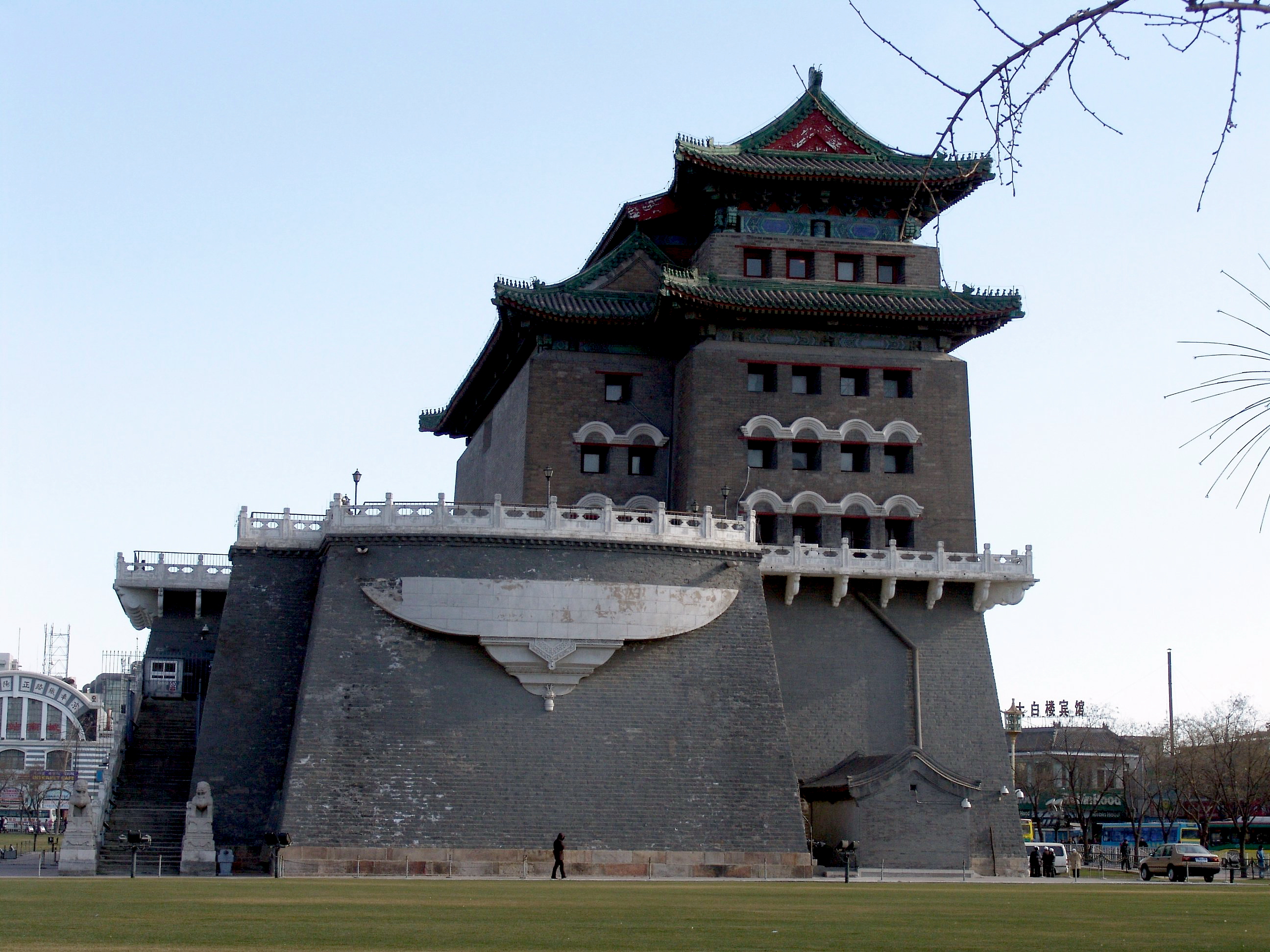
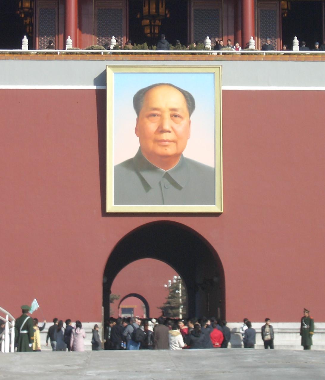
| | | | North is in the upper right-hand corner. The bus let us off on Qian Men Dajie just before the Square. I was already in an ill humor because I knew that where we were standing was where the City Wall had been torn down and around the corner was the Square that was formed by more desecration and destruction. Wendy started by pointing out the Qian Men (Zhenghang Men) straight ahead of us, built in 1419. I only now see on this map that the street was cut through so that the two parts of the tower are no longer joined. As far as I can recall, I only knew to look for the Gatehouse of the Qian Men (no attribution available), which was and still is the tallest of all gates in the City Wall. I didn't know to look for the Arrow Tower (Photo by Saad Akhtar) of the gate across the road. | | | | The visit started, perhaps appropriately, with a minor crisis the we, as kindergarteners, were kept unaware of. Wendy turned us around the corner and up the street along the museums and blithely just chattered away as we walked under the trees—but not in the Square. Whatever her Plan B was I don't know, because all of a sudden we stopped when there was some military activity across the road in the Square. At this point, she finally told us that things are OK now and the Square is open. It had been closed! We backtracked a bit and crossed over to where there was a security checkpoint in the fence so that we could enter the Square and proceed with Plan A. It just seemed so typical, and did not help my ill mood. Nor did the overcast sky, for which I was carrying my collapsible umbrella, but it didn't rain at all—the heat and humidity just continued. | | | | We crossed to the center of the obscenely large Tien'anmen Square that had neither trees or benches. Just picture a paved airport parking lot with no cars, but with people wandering around. What a wasteland. Turning around, we could see behind us the Monument and Mausoleum (no attribution given), that is the ten-story Monument to the People's Heroes and the Mausoleum of Mao Zedong in the background (check map). We were told that the Mausoleum could be visited—not that we had any time—but I had no interest. I've also read that it's unclear if it's really him, a wax statue, or a wax overlay on top of him. Nothing I need to know or want to find out. | | | | Continue checking the map to understand this 180° panorama (Photo by Saad Akhtar). Click to enlarge to inspect ● on the left the view to the west, which includes the Great Hall of the People, used for ceremonial activities, meetings of the Communist Party, and meetings of Parliament; ● straight ahead the view to the north with the Tian'an Men; and ● on the right the view to the east, with the museums, largely dealing with political history. But aside from the barrenness around you, the most chilling thing in this cold-weather picture is subtle. Look around. Any ideas? | | | | In the previous picture, take a closer look at all the lampposts (Photo by Joshua Doubek) fitted with security video cameras. The Square is also heavily monitored by uniformed and plain-clothes policemen, and, although I didn't see any, I understand now that there are numerous fire extinguishers in the area to put out flames should a protester attempt self-immolation. Nice place, right? | | | | Mao wanted this wasteland to be the largest city square in the world at about 880×500 m (960×550 yds). Records show that apparently it's the fourth largest, since there are three lesser-known ones that are obscenely larger, and quite a few lesser-known ones that are smaller, but still huge. Way down on the list is the first name I recognized, Place de la Concorde (Paris), which is just 20% of the size of Tien'anmen Square. These are other squares I've heard of, and also visited, and the percentages in size they are of this Square: Red Square (Moscow) 17%; the New Haven Town Green (Connecticut, US), apparently the largest square in the US, 15%; Zócalo (Mexico City) 13%; Palace Square (St Petersburg) 11%; Wenceslas Square (Prague) & Place de l'Étoile (Paris) 10%; Piazza del Duomo (Milan) & Schlossplatz (Berlin) & Washington Square (New York) 9%; Praça do Comércio (Lisbon) 7%; Trafalgar Square (London) & St Peter's Square (Vatican City) 5%; Alexanderplatz (Berlin) & Columbus Circle (New York) & Piazza San Marco (Venice) & Plaza Mayor (Madrid) 3%. Is there something wrong with all of these cities that they have no claim to such gigantism? | | | | At the upper end of the Square were the photographers I described in another posting, waiting like vultures to take pictures of tourists. But I'm no tourist, I don't approve of pictures with a famous icon used solely as a background, and I was in a foul mood anyway, so I stood aside, even as the photographer pursued me to join the group picture. I continued reviewing my surroundings on the Square while the rest of the group was photographed, the results to be purchased, voluntarily, at the hotel that evening. Then it was time to cross Chang'an Dajie to the Forbidden City—but we were fenced in. No problem. A ramp leads down to the Metro station under the street where one leaves the secure area of the Square, crosses under the street, and comes up on the sidewalk before the much less controlled area of the Forbidden City. | | | | In sum, Tian'anmen Square today is famous only for being famous—or infamous, as the principal cite of the June Fourth demonstrations. And in that regard, we need to mention the statue that was put up, and torn down, that of the Goddess of Democracy. It was erected right in the Square, between the Monument and the Tien'an Men, at a height of 10 m (33 ft) over four days, by students from a local art school. It was made out of foam and papier-mâché over a metal frame, and made as large as possible in the belief that the larger it was, the less likely it was to be destroyed. But destroyed it was, though it's been copied many times around the world. This replica is located in Canada, in Vancouver BC (Photo by Dr kwan). | | | | But probably the most famous image of all is of the unknown individual referred to as Tank Man, also as the Unknown Protester, who temporarily stopped a column of tanks from proceeding to its destination in a show of nonviolent action. He acted on June 5th, the morning after what turned out to be the violent end of the demonstrations suppressed by force by the Chinese military. Contrary to what I'd always thought, this did not take place on Tian'anmen Square, but on Chang'an Avenue, which lies between it and the Forbidden City. In addition, it didn't take place between the two at all, but two blocks east in front of the Beijing Hotel, whose height is a point of significance. This hotel complex is on the north side of the street and is on the block that runs up to the famous and upscale Wangfujing Avenue, whose metro station is shown on the city map you're keeping on the side. The man stood in the middle of the broad boulevard, directly in the path of the column of tanks heading east. Pictures show him in a white shirt and black pants with a shopping bag in each hand, a perfect image of day-to-day life. The tanks stopped and the man gestured with his bags. The lead tank tried to drive around him but he kept blocking it. Finally the lead tank turned off its engines, as did the others, resulting in a nonviolent impasse. | | | | The man then climbed onto the lead tank and tried to talk into various openings, eventually apparently having a short conversation with someone until the commander emerged from the hatch. The man got down, engines were started again, and the man got in front of the tank once again, continuing the impasse. What then happened, according to video footage, is that two figures in blue appeared, pulled the man away, and disappeared with him into the nearby crowd, and the tanks continued on their way. But there is disagreement as to who the two men might have been, according to Western reporters. It's possible, ominously, that they were security officers, but it's also thought that they might have been local citizens concerned for the man's safety, who wanted to keep him from trouble. | | | | Though there have been guesses as to the man's identity, no one really knows, nor does anyone know of his fate. Chinese officials have claimed nothing happened to him. One strange possibility is that the man did just disappear into the crowd, never knew of the pictures taken of him circulating the world, and still lives locally unaware of his celebrity. But the answer is not known. Still, nine years after the event, Time Magazine listed him among the hundred most important people of the 20C. | | | | The pictures referred to were mostly taken from upper floors of the Beijing Hotel, which explains the high perspective of the pictures, of which there are several, all of which had to be smuggled out of China, often with difficulty, by Western reporters. | | | | The most famous picture was the one taken by Jeff Widener of the Associated Press from the 6th floor of the Beijing Hotel, one of four similar versions he took. It shows a close-up view, clearly taken from a distance, of Tank Man with four tanks. It has the advantage of compactness and intimacy. However, it should also be viewed in conjunction with the wider shot taken by Stuart Franklin of Magnum Photos from the 5th floor of the Beijing Hotel, which shows the whole story of the full column of tanks coming down the street. Here we can see that he wasn't just blocking a few tanks but an entire division. And in this view, you can see Tian'anmen Square in the distance to the west. As an ensemble, these photos are widely considered among the most iconic pictures of the 20C. | | | | Forbidden City / Palace Museum (Gu Gong) So there we stood on the sidewalk, having come up the ramp (with our wheelchair and pusher) out of the Metro station, in front of the gate, the actual Tian'an Men, ready for the second part of this adventure. But first we really should look at the name. I'm getting tired of saying I don't speak Chinese (as some readers do), but after a while, you can't help learning words here and there; just think of what we managed with the names of the ring roads. Well, we should know men by now as meaning "gate', and I've been regularly using it. Perhaps we know, or should learn now, that 'an means "peace", as in the ancient city of Chang'an—we're standing next to the street with that name—which means "Perpetual Peace' and the city that took its place, Xi'an, which has to mean—what? | | | | Why, Western Peace, of course. New, perhaps, is tian. Later, when we visit the Temple of Heaven, or Tian Tan, we'll see the word again, so it means "heaven". So what do we have in Tian 'An Men? Heaven-Peace-Gate. You can see why it's translated as the Gate of Heavenly Peace. You can also see why these words in transliteration only look confusing when run together, especially since, when written in hanzi characters, they're separate. Even Xi'an should more logically be Xi 'An. But I'll fight that battle another time. | | | | The only problem now is that, here on the sidewalk, we're too close to see it, so we have to mentally spring back to the Square to get a better view of the Tian 'An Men from a distance (Photo by Daniel Case). The first thing that struck me when I saw it was the ugliness of its lower part. I even asked Wendy at the time if that was how it always was, which she affirmed. It's my opinion that the bottom part of the Gate has all the charm, freshly painted as it may be, of the back wall of a supermarket, near where they keep the dumpsters. What a letdown. | | | | The upper part of the gate, though, which is the gate house, is quite charming, as it includes the impressive Imperial roof styling (attribution not given). The gate was built in the Ming Dynasty in 1420, but has been rebuilt many, many times after wars, natural disasters, and deterioration. The most recent was in 1969-1970, when it needed to be completely rebuilt, but what was done was described euphemistically as a "renovation" to keep public concerns at bay for this national monument. | | | | The lower wall is further defaced, in my opinion, by the two placards, which read in Chinese "Long Live the People's Republic of China" and "Long Live the Great Unity of the World's Peoples". And of course, there's Mao's portrait (Photo by Poco a poco). Wendy pointed out that each October 1, the founding day of the PRC, the portrait is rehung after being repainted. I read further that this is done by the original artist, and is done because of the effects of weathering and air pollution. It weighs 1.5 tons and is 6×4.6 meters (yards) in size. Enough. Let's go inside. | | | | But what is it the entrance to? Even when there, with maps in hand, I thought we were entering the Forbidden City, yet wondered why there were gardens. When we came to the Meridian Gate, it was pointed out as being "important" rather than being the actual entrance. When we went beyond, it was a confusion of buildings, some that had been public, some private for the Imperial family. It was, even with my map in hand, a cacophony, a confusing embaras de richesses. The only thing I remember clearly doing was trying to spot the royal throne inside a large room. Well, now I know a lot more, as do you, if you've been following. The Tian 'An Men is not the entrance to the Forbidden City at all, despite what myriad tourists allow themselves to believe. It's the entrance to the Imperial City, period, and the gardens are in the buffer zone for the palace. However, it is the largest of the gates to the Imperial City. | | | | I found a very nice way to illustrate this. Copy and paste this link, then click to enlarge, and you'll find, not a picture, not a drawing, but a 3-D SimCity replica of the area:
http://www.dingsanbai.com/wp-content/uploads/2011/11/forbiddencity.jpg
| | | | The Square should by now be recognizable, as well as Chang'an Avenue down by the Beijing Hotel, and Tian 'An Men. I see now that there's a bit of a moat there with bridges. I did not see that at the time, perhaps because the Metro exit brought us up beyond it. Entering, you see an intermediate gate, with parkland and the odd pavilion on both sides. Then you come to a moat, which is unfortunately colored an unreal bright blue on this simulation, with the Meridian Gate. The scale in actuality was so large, that, as we entered the gate I was unaware we were crossing a moat! On this map it's much easier to see the spacious public palace areas in the foreground, and the warren-like little residential areas in the back. There are so many pavilions and buildings that it's easy to see why the palace is called a (forbidden) city. Find the little garden in the back, and then the exit on the north side over a moat that I DID see, and walked along, up to the northeast corner to get the bus. For future reference, note the contemporary government buildings on the lakes in the Imperial City buffer zone to the west of the palace. | | | | At this point, I need to go back to the beginning of my knowledge of this subject, which is not here in Beijing but in Taipei, when I was in Taiwan four years earlier (2009/43-44). One of the essentials I really had to see there, and which I really enjoyed, was the National Palace Museum. I understood correctly then that, in the 1930s, with the Japanese invading, the extensive collection of artwork and artifacts based on the Imperial collections of the Ming and Qing dynasties was evacuated from the Forbidden City. At the end of WWII, part of the collection was returned, but part was brought to Taiwan in 1948 by the Nationalists. I understand this part was relatively small, but of high quality and is today exhibited in the National Palace Museum in Taipei. I suggest the reader refer to 2009/44 Ctrl-F "National Palace Museum" to read of the grapefruit-sized ball of ivory carved into 17 balls, one inside the other, each one carved in a hollowed-out lace-like pattern. There are pictures of the green-and-white jadeite cabbage (bok choy) carved from one piece of two-color jadeite so that the green is at the top and white at the bottom. I have a coaster on my coffee table showing this. There is also a picture of a stone that looks like a cut of meat, made of jasper. They are all exquisite museum pieces. | | | | But my error in the National Palace Museum in Taipei was that the Palace Museum in Beijing with the rest of the collection was an art museum in the Forbidden City. Makes sense, right? Wrong. The Palace Museum IS the palace, and has been since 1925, after the last Emperor was finally evicted the year before. Put another way, the Palace Museum is the Forbidden City. I did not understand this yet even when I was there, and was wondering why we didn't go into some art museum as part of our tour. In Chinese, the Palace Museum is called the Gu Gong, or "Former Palace", which I suppose makes the situation clearer than in English. Actually, I do believe there IS an art museum within the complex, but I've already seen the cream of the crop, and don't miss at all not having seen this collection. In retrospect, I'm intrigued at how the Taipei and Beijing experiences have blended together and complemented each other. | | | | The Gu Gong / Palace Museum / Forbidden City is the largest and by far most intricate Imperial palace in China. It's a complex of red-walled wooden buildings and pavilions topped by glazed ceramic tiles, which on almost all buildings are an Imperial yellow, which is the color of the Emperor. (I didn't realize they were wooden when I was there or the significance of the yellow tiles—I learn so much more in post-trip research, which enhances the experience.) | | | | Reportedly requiring a million workers, construction was completed 1420 on the location of an older palace, but lakes excavated in the 12C were kept and expanded. The palace housed 24 Ming and Qing Emperors from then until 1924 (a half-millennium plus four years)—the Emperor that abdicated in 1912 was allowed to live there in the Inner Court (the residential section) another dozen years. | | | | The Forbidden City is laid out according to the compass points, with most major halls opening to the south, considered the most eminent direction and the direction associated with Imperial rule, which explains why the former Imperial Way in Tian'anmen Square ran to the south. This axis remains the central axis of Beijing. | | | | In the south-center of the complex is the symmetrical outer court, with ceremonial halls. Surrounding the outer court, in an inverted U is the asymmetrical inner court, which served as the living quarters and consisted of smaller buildings and some gardens. There are reportedly 980 buildings over 72 ha (180 acres), measuring 961 m (3,153 ft) north to south and 753 m (2,470 ft) from east to west--which is a lot of walking. All buildings exhibit traditional Chinese palatial architecture, and have influenced culture and architecture in East Asia and elsewhere. It's been declared a UNESCO World Heritage Site as the largest collection of preserved ancient wooden structures in the world. | | | | Because of fires and ransacking over time, fewer buildings remain from the Ming period, and more are Qing buildings. I now find out that only half of the Forbidden City is open to visitors. This is expected to increase to 70% by 2020 after further major renovations are done beyond what has been completed so far. Still, at present, some of the structures, particularly in the residential Inner Court, still present a gentile shabbiness. | | | | And of course, the name is unique. The simple explanation is that you couldn't enter without the Emperor's permission, but there's just a bit more to that. The Chinese name is Zi Jin Cheng. We've seen that the last word means a walled city, as in my Dongcheng neighborhood, also Xicheng. (This is of course ironic in that those walls are now gone.) The whole name translates as "Purple Forbidden City". The first word refers to the North Star (I'm not sure why it's purple), which in traditional Chinese astrology was the abode of the Celestial Emperor. The Forbidden City, as the residence of the Terrestrial Emperor, was its counterpart, forbidden to the general public. Thus the Chinese name, confusing to Westerners as it might be, makes reference to both heaven and earth, tying them together, which is something we'll see again when we go to the Temple of Heaven. | | | | We left off with having exited the Metro station in front of the Tian 'An Men, so let's enter through it. You can refer back to the SimCity version, but copying and pasting this link in another window for this layout of the Forbidden City will be more helpful, and then click to enlarge it:
http://www.travelchinaguide.com/images/map/beijing/palace-museum.jpg
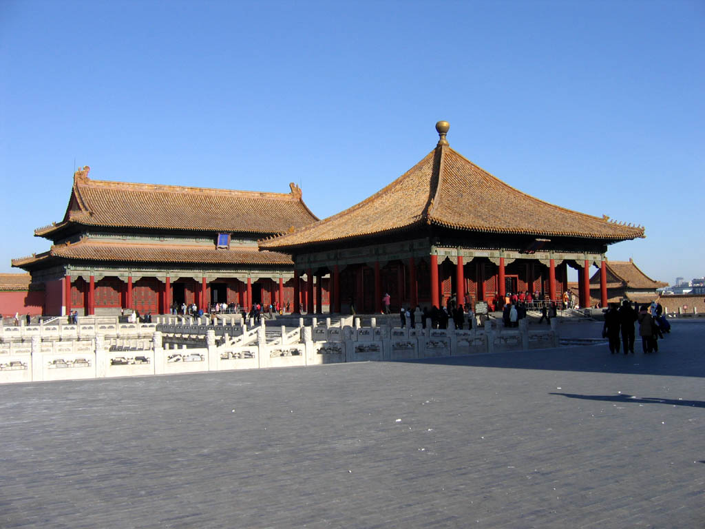
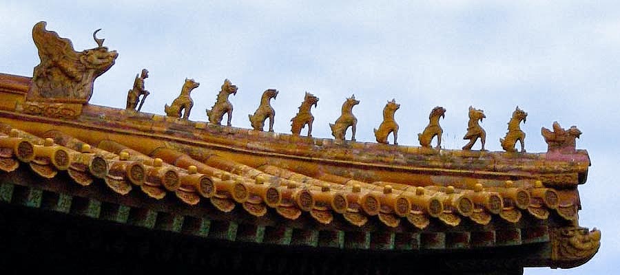
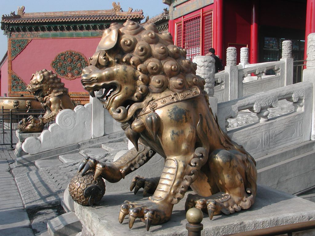
| | | | This is the very map I'd printed out in advance and had with me, yet it still seemed such a potpourri of buildings, pavilions, people, and confusion, that I only straightened it out in my mind, happily, now. I think I can walk us through it with ease. Leaving the Tien 'An Men at the southern end, we now realize we are entering the Imperial City only. There's an intermediate gate between the gardens, which acted as a buffer. Now realizing that there's a moat around the palace walls, here visible on both sides, we come to the Wu Men, or the Meridian Gate (Photo by Gisling), built in 1420. It's more than just an "important" gate, it's the entrance to the Forbidden City, today the only one the public can use. Check out the layout again. The wall around the Forbidden City is pierced only once on each side. We're entering on the south side by the Meridian Gate. We'll exit, as the public must, by the Shenwu Men on the north side, the Gate of Divine Might (translated differently on the layout). The Donghua Men, or East Glorious Gate and Xihua Men, or West Glorious Gate are not centered in their respective walls, but located way to the southern ends. | | | | It was believed that the Terrestrial Emperor was the Son of Heaven and should live in the center of the universe. They considered that the noon meridian went through the center of this, the largest gate, down Tian'anmen Square and beyond, and built the entire Forbidden City around this axis. | | | | Look again at the picture to see that the Meridian Gate has five openings, a large central one, two others near it, and two further to the side. Three guesses (really) as to who got to use the large central one, and the first guess doesn't count. | | | | Your first guess that it was the Emperor is of course right. The second person that could use it could do so only once in her lifetime, and that was the empress, only on her wedding day. For the third, we have to reflect back to the Chen Clan Academy in Guangzhou (2014/1), which was originally built to prepare younger family members to live and study for the Imperial examination, the civil service exam given in Qing Dynasty China to select the best possible candidates for official administrative positions. It was the three top scholars of this triennial examination who were allowed to leave the exams through the central opening. All other officials and servants had to use the four side arches. Not knowing the significance at the time, I really don't quite remember which opening we walked through, but it has to have been the center one. | | | | I made a note of one example of Chinglish I found in the Forbidden City: "Relic protected, no scratch". So when you get that itch, resist the urge. | | | | The rest of the layout can be greatly simplified. Disregard structures on the lower sides. We pass through the Gate of Supreme Harmony and come three important buildings with the word "harmony" in their names (only two are named on the layout). They, plus the side buildings we're disregarding, constitute the Outer Court, the ceremonial center of the palace. | | | | The closest parallel I can think of is the tour of the White House. One visits the large public rooms on the ground floor, while the presidential living quarters upstairs remain private and off limits. The Outer Court is like the public rooms. The inverted-U surrounding it to the north is the Inner Court and would have been private in Imperial days. | | | | Passing through the gate one comes to the main courtyard (no attribution given) of the Forbidden City (click for detail), with its most prominent feature, the Hall of Supreme Harmony (click) (Photo by Saad Akhtar). It's the largest hall in the complex and rises some 30 m (98 ft) above the square on three levels of a base made of marble. This building was the ceremonial center where the Ming and Qing Dynasty Emperors held their enthronement and wedding ceremonies. It's also the largest surviving wooden structure in China. While all three of these "Harmony" buildings encompass a throne, this one has the main one, the Grand Chair of State, the Dragon Throne (Photo by DF08), located in the center of the Hall of Supreme Harmony in the center of the Forbidden City in what was regarded as the center of the world. All the gates and walkways a visitor had to pass through before reaching the Emperor on the Dragon Throne were intended to inspire awe. Our group climbed the marble stairs, and some of us squeezed into the crowd of locals to peek beyond the barrier into the dark interior to see the throne. | | | | Behind this building are the Hall of Central Harmony and the Hall of Preserving Harmony (Photo by Jacob Ehnmark). The former, the smaller building in the foreground, is shown but not named on the layout. It was used by the Emperor to prepare and rest before and during ceremonies in the hall in front of it. The latter, behind it, was used for rehearsing ceremonies and was also the site of the final stage of the Imperial examinations. | | | | One aspect of Chinese Imperial architecture is definitely worth mentioning, the Imperial roof decorations, which were only allowed on official Imperial buildings. They appeared on the roof along the ridge where two sides came together, near the lower corner. They consist of a row of small figures, made of glazed ceramic, forming an outward marching procession. This shows a short, simple one (Photo by Leonard G.) with only one central figure, indicating a minor building. The lead statuette is always a man riding a phoenix, representing the authority of the state. At the end of the procession there's always an Imperial dragon. In between will be an odd number of mythical beasts, either 1, 3, 5, 7, or 9, representing the status of the building and the importance of the duties performed in it. While the maximum number of mythical beasts is nine, a number frequently encountered (Nine-Dragon Screen), the Hall of Supreme Harmony is unique in having ten figurines (Photo by Leonard G.) between the phoenix and dragon, indicating the highest status in the Empire for this building. But a careful inspection will show there are only the maximum number of nine mythical beasts. Behind them is instead a special tenth figure, an immortal guardian holding a sword pointing downward in front of him. He's called a hangshi, which means "ranked tenth", and is unique to this building. Finally, note in both of these last pictures the imperial yellow glaze on the roof tiles reserved for the Emperor. | | | | After the three "Harmony" halls, our group continued north on the west side and stopped in a number of somewhat downtrodden residential courtyards with views into rooms, but this whole area was not particularly interesting. Perhaps the ongoing renovations will improve it. I was also aware there were two things I was wondering if we'd see, but didn't. We did not go north on the east side, and perhaps this area is not ready—although actually, after a while, enough is enough. But a bit of recent inspection of the layout shows that one of the items we didn't see, the Nine Dragons Screen in the Forbidden City (Photo by Stratos Malasiotis), is located here (see layout), and an often-seen pair of guardian lions (Photo by Allen Timothy Chang) is supposed to in front of the same building. I'd been wanting to see one of historic Beijing Nine Lions Screens ever since I'd seen the copy in Hong Kong, but I knew I'd scheduled seeing the one in Beihai Park, so that didn't bother me. And I've seen plenty other guardian lions. Still, on my own, I'd have sought these items out. | | | | When we reached the Imperial Garden at the top of the layout, I knew we were almost done. It seems to be the only garden within the walls of the palace itself, but it didn't impress particularly. However, there was one thing I saw there I'd never seen anywhere else. There was a pool around a fountain with coins in it, which is fairly standard, but this pool also had paper money floating in it. I assume they were of low denomination, but that was unique for me. | | | | We left the palace at its north end via the Shenwu Men (Photo by kallgan). The sign simply means Palace Museum. We had to walk to the northeast corner to get our bus, but it was pleasant to finally see some beautiful wall with corner towers and moats (Photo by Charlie fong). This is actually the northwest corner, but they're all the same. But still, it made one think again about what was lost when the City Wall was taken down. | | | | China Railway Museum We went to one of our spectacular lunches, and in the afternoon, mercifully only one short visit was planned, to the China Railway Museum, also known as the Beijing Railway Museum, located some fifteen minutes northeast of downtown. After the boring fiasco at the Shanghai Railway Museum I was quite dubious, but this was a totally different, pleasant experience, since it had rolling stock exclusively. It was in an airplane-hanger type of facility with a large concrete floor that had eight exhibition tracks leading right and eight leading left (Photo by choo chin nian). Locomotives (Photo by 颐园新居) and assorted passenger coaches (Photo by 颐园新居) were crowded together one behind the other. In some cases you could climb up and sit in the cab (Photo by 颐园新居). This YouTube video (3:40) shows more. At the very end, see if you can pause the video at 3:35 to catch what for me was the pièce de résistance of the museum and which here is relegated to a backdrop for the end shot. It's the little sweetheart in the foreground, although when I was there it had been moved to its own place in the central area, which I would consider a place of honor.
| | | | The very oldest locomotive in China was the Rocket of China dating from 1882. More about that in the next posting when we get to Tangshan and back to Mr Sun. What you are looking at here is the second oldest locomotive in China dating from 1887. It's name is rather odd, and to verify it, you can see it written on the cab door: 0. I suppose you just call it "The Zero". Its smokestack is longer than the Rocket of China and I think that makes it cuter. I wondered if either of these two was the oldest locomotive I've ever seen, so I checked, and it was close, but not the case, by one year. When I was in Norway on the Deutschland to Greenland in 2012, I stopped in Stavanger at the rail station, where they exhibited, inside the station itself, the Hugin of 1881 (2012/18, Ctrl-F "Hugin"). | | | | Wangfujing That evening back at the hotel there was a little free time, so I decided to try to walk the neighborhood of the hotel, as I'd done with reasonable success in Shanghai. From coming and going I knew the neighborhood was among the new overbuilt and over-modernized areas, where hutongs there for a long time had been plowed under. We'll explain more about the neighborhoods of little back alleys and lanes called hutongs later when we actually visit a preserved hutong neighborhood (!!), but I knew that this hotel neighborhood would represent the third (and, thank goodness, the final) area of loss for me after the City Wall and Tien'anmen Square. | | | | I knew the larger area was the upscale Dong Cheng / East City, and we'd been informed in advance that we'd be staying at the Park Plaza Beijing Wangfujing. It was a perfectly fine hotel with all conveniences. I can't fault it, only its neighborhood. Frommer gives it one star, and says it has "good value for business or leisure guests looking for comfortable rooms in a good location without the usual amenities." Well, I don't use gyms urban swimming pools and didn't miss those "amenities" in the slightest. I only disagree about the area it was in. | | | | I've learned more about the hotel since. I thought it was a local isolate, but now, having looked up more, know there's a Park Plaza hotel chain. On top of that, they have three hotels in Beijing; there's also a Park Plaza Beijing Science Park and a Park Plaza Beijing West, so I finally understood fully the meaning of Park Plaza Beijing Wangfujing. Also, before leaving, I'd checked that Wangfujing was a major commercial street nearby that gave its name to this entire section of the Dong Cheng. This is not odd--streets often give their names to districts--when you consider that, in New York, the whole financial district is called "Wall Street" and the entire theater district is called "Broadway". Similarly, this whole commercial district was called Wangfujing. So when I set out on my evening walk—and it was still hot and humid at 7:00--I wanted to get the feel of the neighborhood and perhaps walk over to the actual Wangfujing. | | | | Copy and paste this otherwise rather extraneous map, which is valuable in that it shows the streets of the Wangfujing neighborhood:
http://images.mybeijingchina.com/hotel/beijing/crowne-plaza/location-map.jpg
| | | | The blue line is the moat around the palace, so you see we're close. First note how many regular streets in this neighborhood use "hutong" in their name, some of them being large boulevards. Perhaps some in the back streets are genuine lanes or alleys, but it wasn't worth it to try going searching. I can only speculate that, when the real hutongs were plowed under, some of their names were maintained on the new larger streets. Some may consider that a form of preservation. I think calling a major boulevard a hutong is obscene. | | | | The Crown Plaza Beijing Wangfujing is on the right, between Ganmian Hutong and Jinbao Street, which is its street address. I turned west to where it crosses Dongnan and becomes Jinyu Hutong, which irritated me. But irritating me more was the fact that the things I saw starting on Jinbao and continuing—and I wrote names down for posterity—were a Ferrari showroom, a Mercedes Benz showroom, and a Rolls Royce showroom, intermingled with a Godiva chocolate shop, a Chanel boutique, and an Apple Store. You mean to tell me I came to China to see THIS? | | | | In the heat, I continued down the two VERY long blocks, past office buildings that could have been in Midtown New York, and finally reached the intersection with Wangfujing. Straight ahead I could see the palace wall in the distance, but I wasn't about to go any further in that direction. I looked down Wangfujing, which runs several blocks further off the bottom of the map to the Beijing Hotel, the scene of Tank Man. It appeared as a broad, pedestrianized street. I had no energy to actually walk down it to look at shops, to probably find more Godivas and Ferraris, neither of which I needed, so I turned back to the air conditioning of my hotel. | | | | So now, after the fact once again, I researched Wangfujing, which is apparently popular for shopping both for locals and visitors. It has been commercial since the Ming Dynasty, and in the Qing Dynasty, a well yielding fresh water was found here, followed by the building of ten aristocratic estates and princely residences. I am informed that "Wang Fu" means "princely mansion" and "Jing" is "well", so there we have Wangfujing, or perhaps, to my preference, Wang Fu Jing, that is, Princely Mansion Well. | | | | This is pretty much the view I had down Wang Fu Jing (Photo by Ian Sewell). I understand this marker designates and commemorates the actual Jing that gave the street its name. | | | | So let's leave our shoppers on Wang Fu Jing (Photo by Saad Akhtar) and go rest for the evening. Tomorrow is another big day, and includes the Great Wall of China. | | | |
| |
|
|
|

