|
Reflections 2014
Series 4
April 12
China XII: Shanghai I
| | I said earlier there are two stops I was looking forward to, Shanghai and Xi'an. I had to work hard to have Xi'an added to my itinerary, but Shanghai was already included. I looked forward to it, especially having reviewed its Concession history, and was amply rewarded. | | | | Shanghai It's the prettiest name, in my opinion, of any city in China, and perhaps anywhere, and certainly one of the most exotic. In contrast to this, unfortunately, it's also developed into a verb, with very negative connotations. | | | | | | In English, it's "to shanghai"; German has schanghaien, Swedish sjanghaja. In French it's instead a noun: a shangaïer is the poor sucker who got shanghaied. Tricking, intimidating, or outright kidnapping men off the street in port cities (out of bars, boardinghouses, bordellos), even those with no sailoring experience, was a 19C custom in the era of sailing ships, when a lot of manual labor was required on board. Laws were such that once someone had signed up aboard a ship that had sailed, it was illegal for him to leave until his time was up, even if his signature had been forged. On the US west coast, the practice was common in San Francisco, Portland & Astoria, Seattle & Port Townsend, with Portland eventually leading the way. On the east coast, New York was prime, followed by Boston, Philadelphia, and Baltimore. In Europe, London and Hamburg were the major locations for it. The practice stopped when laws finally were enacted against it. In the US shanghaiing became a federal crime in 1915, which ended the practice. Also, sailing ships were by then on their way out, and newer ships didn't require as much manual labor, anyway. Shanghai would have been a common sailing destination and unfortunately ended up lending its name to the practice. Even though the practice has disappeared, the word hasn't, and it still means to trick or force someone to do something they don't want to do. |
| | | | On a more pleasant note, let's get back to Shanghai, the city. The pretty name has a very interesting origin. Shanghai is written 上海. Of its two syllables, it's the character of the first one that's the more interesting, and on the second, the word. Let's start with what we know. The character 上, with the pole ABOVE the crossbar, means "above, up", while 下, with the pole BELOW the crossbar, means "below, down", so we see that the "shang" syllable is "above". | | | | With the second syllable, "hai", we may possibly recognize having seen that word. If not, I'll quote from 2013/21, where we mentioned "the only island province, Hainan. "Hai" means "sea" as it does in "Shanghai", so Hainan means "Sea South", that is, "South of the Sea". That doesn't make sense until you realize that the sea reference is the Hainan Strait separating the island from the mainland." In the case of Shanghai, what we know as the East China Sea is called the Dong Hai, literally the East Sea. | | | | So "Shanghai" is "Above-[the]-Sea". But what does that mean? And to what extent is Shanghai actually on the sea, or even on the Yangzi River? Well, the name first appeared in the 11C, and Chinese historians have concluded that during the Tang Dynasty, Shanghai WAS actually on the sea—at least more nearly so than today. Standing on sand dunes looking down to the water, you are "above the sea"; perhaps we should say "Upon-the-Sea". Or maybe we should look at it like towns that in English are named "Seaside". | | | | Seaside indeed. While major shipping today, because of size, no longer comes to the downtown area proper but is concentrated instead in the nearby Yangzi River, shipping (sans shanghaiing) is part of what makes Shanghai a transport hub with the world's busiest container port, to say nothing of a hub for rail and air. It's also a global financial center, and by population, Shanghai is the biggest city in China and the largest city proper by population in the world, almost reaching 24 million in 2013. | | | | Let's start by looking at a map of the Shanghai area (Map by Joowwww). If you want to copy it into a separate window, use this link:
http://upload.wikimedia.org/wikipedia/commons/thumb/2/2c/Shanghai_administrative_Puxi_Coloured.svg/949px-Shanghai_administrative_Puxi_Coloured.svg.png
This is a simplified map, with all names omitted, of Shanghai's 17 administrative divisions, which together are the equivalent of a province. The eight principal downtown districts are in color and the nine outlying districts are beige.
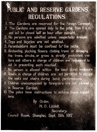
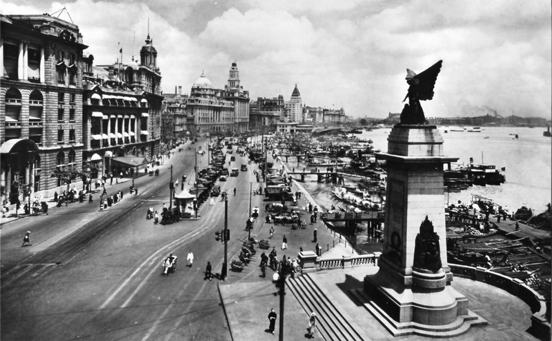
| | | | It's also obvious that the downtown is defined by the local river, the Huangpu, or Yellow River, not to be confused with China's second largest river further north, the Huang He, which also translates as Yellow River. Yellow muddiness seems to define both rivers. Note on the map that in the northern part of the city we find not only the Yangzi River, but actually the mouth of the Yangzi, as it empties into the Dong Hai to the right, or, as we said, the East [China] Sea. We can see that the Huangpu is the last significant tributary of the Yangzi. | | | | So is Shanghai on the sea, as its name tells us? Is it on the Yangzi? Well, yes and no. Technically, outlying areas of Shanghai border on both. But in the sense that London is on the Thames, Paris is on the Seine, and New York is on the Hudson, it must really be said that Shanghai is on the Huangpu. As in the other cities, that's the river you see when you walk along the riverbanks downtown. Perhaps the situation should be best described by saying that Shanghai is in the Yangzi delta, which implies both the river and sea being nearby. I was hoping to get another view of the Yangzi while in Shanghai, beyond the fleeting glimpse I got from the train in Wuhan, but it never happened, and when we took the maglev to Pudong Airport at that eastern point of the city, I specifically asked if we'd see the sea from there and he said no, and we didn’t, so I do have trouble reconciling statements of just to what extent Shanghai is "on" the Yangzi or the sea. | | | | Pudong Airport gets its name from its location in Pudong, which is that large beige district stretching from the airport all the way back to the Huangpu. Pudong is well known, as it forms the entire "other bank" from downtown, like Paris's Left Bank, London's Southwark, or like New Jersey, across the river from New York. For years, I've been reading in the papers how rapidly it's developed, and when I saw it, what it used to look like was hard to believe. A couple of decades ago, despite its location opposite downtown, it was mostly rice paddies. Now the western, in-town section of Pudong bristles with skyscrapers! | | | | There is a quirk in the name of the Huangpu. When it combines with other words, it drops the "yellow" syllable and shortens to just "Pu". When I learned that before going to China, it struck me that that's how Pudong gets its name! It's Pu-East (or, if you insist, Huangpu East). I was further surprised when I found that you can also refer to downtown Shanghai as Puxi, or Pu-West. Knowing about these names ties everything together. About 48% of all the residents of Shanghai live in Puxi. Despite efforts to promote the rapidly-developing Pudong, Puxi remains the center of culture and entertainment. | | | | We can now state that it's the Puxi districts that are shown in color on the map. We'll just name two. The dark green area in the center is the Huangpu district, named directly after the river. It's the city's core, and contains almost everything you'll want to see. I'll also mention that the red area to its west, still central, but at the edge of the core, is the Jing'an district. I mention it only inasmuch as that's where out hotel was, and where I walked some of the neighborhood on my own. Jing'an and the hotel we had were fine, I have no complaints. Still, if I had gone to Shanghai on my own, I'd definitely have stayed right in the center, and as close to the Bund as possible, if for nothing more than for evening strolls. As it was, going to the Bund the two times we did involved visiting from outside, and not living there. That's why I live in downtown Manhattan, the core, the historic Nieuw Amsterdam, and why I prefer my way to travel. | | | | Shanghai Concessions I know different people have different ideas about travel, which I accept, but I do not understand people who will go to an interesting place and look at it purely superficially, like it turned up overnight like a mushroom on a lawn. Places have history, and one misses so much when disregarding it: the past is always present. Shanghai is a good case in point. Up to the mid-20C, almost all of Shanghai was a European city planted in Asia. How can you disregard that? | | | | 2013/23 was our introduction on the concessions in China, and we concentrated on Tianjin. We noted that its multiple concessions were built to supplement what was then called the "Chinese City" at its edge. When we discussed Darien in 2013/24 we noted that the Russian Concession there, too, had been built up around a "Chinese City". But the only former Concessions I had visited thus far were the two that shared tiny Shamian Island in Guangzhou (2014/2), which was so small I could visit it in one hour, and it was always a tiny supplement to the walled city of Guangzhou. Shanghai, like Tianjin, by the mid-20C was just the opposite, a huge Western city surrounding a small, historic "Chinese City". | | | | In that earlier posting we looked ahead to see that Shanghai had had three Concessions, two of which early on joined together. In the 19C-20C period, a time of urban growth around the world, the Concession area expanded to totally overwhelm the original Chinese settlement, and that situation remained until after WWII. | | | | In a nutshell, this is how it came about, and in a moment, once we understand what happened, we can look at a series of interesting historical maps and trace both the growth of the Concessions and of three main roads within them that are major Shanghai streets today. The British Concession was established in 1846, the American in 1848, and the French in 1849. We've discussed how each concession had its laws, its money, its post offices its left- or right-hand traffic pattern. But after a decade-and-a-half, the British and American Concessions merged in 1863 to form what was called the Shanghai International Settlement, parallel with the ongoing French Concession. It's my take that the British were actually running the International Settlement, and it was still thought of as the (enlarged) British Concession. For much of the period, the (former) British Concession remained the business and financial center of Shanghai, and the French Concession became and remained the premier residential and retail district of Shanghai for all Westerners living in all parts of the city. Everything came to an end in 1945-1946 when the regions came under Chinese administration, but to this day, the term French Concession in particular is used to bring to mind the reawakening elegance of that area. | | | | The oldest map I found shows Shanghai in 1884, or use this link in a separate window:
http://upload.wikimedia.org/wikipedia/commons/thumb/b/b6/Shanghai_1884.jpg/616px-Shanghai_1884.jpg
| | | | Click to enlarge slightly. Already, everything is clinging to the Puxi shore of the river. The "Chinese City" stands out to the south, and is very close to a circle. It still had its city walls. Squeezed in around its northern side, in an inverse-U form, is a still very petite French Concession in light pink. It was important that the French have a piece of the riverbank, called the French Bund, but also the Quai de France, and the concession then expanded westward, building on this unusual early shape. | | | | The British Concession, still quite small, is in bright blue, and reaches up to Souzhou Creek, named after the city of Souzhou to the west. What was then the British Bund, today only known as the Bund (no one refers any more to any other bund in the city), ran then, as it still does to this very day, along the riverbank from Souzhou Creek to the main street separating it from the French Concession. In dark pink, across the Creek is the still small American Concession. Even though these two ones were merged two decades earlier and both are under the administration of the International Settlement, this map still shows the two in different colors. | | | | We move ahead to Shanghai in 1907 and have to copy & paste this link in another window:
http://www.lib.utexas.edu/maps/historical/shanghai_1907.jpg
| | | | The Chinese City is still walled, and the Chinese Bund and Quai de France are named here. The French Concession has expanded slightly to the west. As for the International Settlement, the British area, with Nanjing (Nanking) Road already standing out, has expanded considerably to the west south of the creek. Notice the racecourse that has been set up in its new area and the country area known as Bubbling Well. This is the Jing'an District today, where we stayed. The American area has expanded considerably downstream to the east. The railway has arrived. The station building would be built in 1909, but would be later turned into the Shanghai Railway Museum we visited. | | | | Copy and paste this link to see Shanghai in 1912:
http://www.lib.utexas.edu/maps/historical/shang_hai_evirons_1912.jpg
| | | | 1912 was the year the Chinese City lost its walls, to be replaced by broad streets. The French Concession has expanded west considerably. A misspelled Bubbling Well is still identified in the countryside. Find the numbers 1-2-3-4 in the key to note that the French Consulate is still in the French Concession, while the three others are in the International Sector. We'll see on later maps that the French Concession had just as many other nationalities represented as the International Sector. French today spells Shanghai the English way, but the old CH spelling is at the top. I add to this map one more 1912 map:
http://www.lib.utexas.edu/maps/historical/chang_hai_1912.jpg
| | | | We show this so you can click to enlarge to notice how thoroughly French language and culture is ensconced in its concession, as is English in the International Sector, and how other Western languages and nationalities are represented in both areas. How Chinese is this Western city? Hardly at all. Find the Bund, and, starting at the Palace Hotel, trace the Nanjing (Nanking) Road shopping street past the racetrack, now called a recreation ground, to where it becomes Bubbling Well Road leading to today's Jing'an. Now go back to the Bund and find the Public Garden, established in 1886 and today very logically called Huangpu Park, which is the basis for a very well-known, but fictitious, urban legend. | | | | Most of Shanghai being a very Western city, the movements of the Chinese population living in the Chinese City were restricted, that is true. The Public Garden was entirely closed to Chinese people between 1890 and 1928. But there has always been an urban legend that said that there had been a sign at the entrance to the Public Garden that said something like "No Dogs or Chinese Allowed". That story works better in the repeating than in reality. This is a copy of the Shanghai Public Garden regulations from 1917. Regulation #1 restricts the Gardens to the Foreign Community and #4 restricts dogs and bicycles from entering. While #1 is crass and unfair, it's a sign of the times; still, the urban legend wording never existed. | | | | The final historic map is the best, because it's the most recent and the most extensive. It's the map I printed out and brought with me to use as we went around the city, to accompany a modern map. It's Shanghai in 1935, based on a map from that year, but redrawn here by the US military in 1944. 1935 was two years before war came to Shanghai, which was the beginning of the end of the Concessions. You can also copy and paste this link in another window:
http://upload.wikimedia.org/wikipedia/commons/e/eb/Shanghai_1935_S1_AMS-WO.jpg
| | | | I like this map a lot, and took a copy with me because of the detail you can see concerning the last years of the Concessions, and draw parallels with today's map. You may want to do as I've done, enlarge the map and scan across it to see the international, and Western, nature of the city, in both the French and British areas. You see all the separating borders very clearly. | | | | Around the circular Chinese City, by now unwalled, the narrow neck of the French Concession extends well to the west. Let's find our first street of importance, Avenue Joffre. Along with the short Rue de Ningbo (Ningpo) to the right and, to the left, running off the map, Jordan Road, this trio of streets now has the one name Huaihai Road (Huaihai Lu) and remains to this day, one of the two most famous shopping streets in Shanghai, along with Nanjing Road. Huaihai Road is more upscale, and preferred by the locals, while the splashier Nanjing Road, with much of it now pedestrianized, is more the venue of tourists. I, as a visitor and not a tourist, took a look out the bus window down Nanjing Road from the beginning of the pedestrian zone, but felt no need to venture down its length. We did walk across Huaihai Lu, but I'm no shopper, so I didn't really miss anything. | | | | This is a view of Huaihai Road in the 1930s further down from where we were. Note the Cathay Theatre on the left, built in 1932 (I cannot explain why the traffic is on the left here in the French Concession). This is that same intersection today (Photo by Baycrest), and that's still the Cathay Theatre on the left. I just googled it, and it shows both Chinese and foreign films. Wanna go? Anyway, I find it interesting and very indicative that many locals still call the major center section of Huaihai Road by its original name, Avenue Joffre. Some things never die. | | | | Within the International Settlement, there seems to be nothing of interest in the ex-American Concession north of Suzhou (Soochow) Creek other than that the old rail station is still at its edge (notice how the old Wade-Giles spelling always favors, and is closer to, the English spelling and pronunciation rather than concerning itself with the Chinese pronunciation as the pinyin spelling does). So let's concentrate on the ex-British Concession, starting by the river. Notice first how at this date, and for a few decades beyond, Pudong (Pootung), despite being opposite the very center of the city, has few buildings, mostly industrial, and beyond is nothing but rice paddies. This is a stark contrast to the bristling of skyscrapers that has developed in the last couple of decades. | | | | Start with the Bund. Most, probably all, of these buildings are still there, and are the premier sight in the city. Note the Public Garden with the British Consulate, and just find and make note of two clusters of names we'll discuss more later. Find where Nanjing Road (Nanking Road) takes off, our second major street, and note the Palace Hotel, Cathay Hotel, and Sassoon House. Further down note the [China] Bank of Communications, the Customs House, and what is here called the H & S Bank (Hong Kong & Singapore Bank) famous today as the HSBC Bank (HSBC=Hong Kong & Shanghai Banking Corporation)—some things do change, slightly. | | | | It can be said that the heart of Shanghai today starts at the Bund and is bordered by the two shopping streets, Nanjing Road in the north and Huaihai Road in the south, both streets stemming from the two Concessions. Go back to Nanjing Road and follow it. Today, three blocks in, at Henan Road, its pedestrianized section starts (today) for a considerable distance. Trace it to the still-existing recreation ground we've watched develop over the years. This entire section, the shopping area, is now called Nanjing Road East. Continue on the same road, now called Bubbling Well (a familiar name!) Road, past Bubbling Well Cemetery, to where it leaves the Concession and joins another road. Bubbling Well Road is now called Nanjing Road West, extending a famous name considerably further. (And into today's Jing'an!) | | | | Today, the recreation ground is divided in two. A major street cuts through it, dividing it to the People's Park on the north side and the so-called People's Square on the south side, which is the site of Shanghai's municipal government building, a museum, and concert hall. | | | | OK, just one last road, and you'll see where all this is leading to (pun intended). Go back to the river, and let's investigate the street I referred to earlier as a "main street". That's because it was then, and remains today, the principal east-west street in the city. Then, it divided "Britain" and "France", and remains the southern border of the Bund. Look at its British name: Avenue Edward VII. (This is China?) | | | | Move west on this street. Just after the southern end of the recreation ground, while this street continues three more blocks with the British name, the border nevertheless drops south a short distance and turns on to the very French Avenue Foch, and the main street continues with this French name past Bubbling Well Cemetery. How international (though not Chinese) this must have seemed at the time. After passing Bubbling Well Road, Avenue Foch becomes Western Road. | | | | So! What does this mean today? This entire main street, formerly consisting of Avenue Edward VII, Avenue Foch, and Western Road, now has one name, and it's a Chinese one, so some things do change after all. It's all now Yan'an Road (Yan'an Lu), unfortunately named after Yan'an, the Communist base during the Chinese Civil War. Sic transit. | | | | But there's more change. In the mid 1990's an elevated expressway was built along Yan'an Road, which we used regularly, and it doesn't look at all as ugly as you may think. It runs from the west at Hongqiao Airport and Rail Station, follows the original road in its entirety, and originally ended with a left turn onto the Bund. At another point, a tunnel was built under the Huangpu River, connecting the downtown end of the expressway with Pudong on the other side. This much I saw and noted when I was there. But I just now learned to my great surprise that there has been another improvement. In 2008, to improve traffic on the Bund, in additional to that ramp leading to surface traffic on the Bund, a two level tunnel, one level in each direction, was built UNDER the Bund and Souzhou Creek to funnel traffic to the north. I had no idea when I was on the Bund that there was a tunnel below, and two levels at that. | | | | The last thing to talk about before resuming the regular narrative involves going back to the former Bubbling Well Cemetery, because when I was researching the trip before we went I found something amazing. Look at the indication of the German School and Church, something which already piques my interest for what it was. Note its unusual location in an odd geographic corner opposite both the British Concession AND the French Concession. Depending how you cross the intersection, you end up in either one or the other. Today, most of what you see has changed, and I was absolutely shocked when I was checking hotel addresses before the trip to find out that the rather nice Hotel Equatorial where we'd be staying was located just where the German School used to be! This area is in the center of the Jing'an District I later learned so much more about. I immediately planned before the trip to spend the first evening, if I couldn't walk the Bund, to walk into the two Concessions to see what a feeling I could get. And on the ex-British side, I discovered that the former Bubbling Well Cemetery was now the locally popular Jing'an Park, and on its north side, across the former Bubbling Well Road now Nanjing Road West, was the rebuilt Jing'an Temple, which gives its name to both the park and the district. I was so pleased that, if we weren't going to be downtown by the Bund, these seemed like a decent alternative. And it was. | | | | To now bring our map search up to date, cut and paste this modern map of Shanghai in another window:
http://www.johomaps.com/as/china/shanghai/shanghai1.html
| | | | With the historical background knowledge we have, it's easy to spot most things. Find the expressway from the airport in the west and the tunnel under the river. Note how the traffic can turn under the Bund and exit beyond Suzhou Creek. Note how built-up Pudong is today. Revel in the enjoyment of having the historic basis help us in understanding what's in Shanghai today. | | | | Visiting Shanghai We left off the narrative having finished the Nanjing portion of Day 5 at the Ming Tomb and taking the train to Shanghai. I've since found a very good map showing transportation in the entire region of the Yangzi River Delta. Cut and paste this link in another window:
http://www.johomaps.com/as/china/yangtze_delta_eng.html
| | | | This is eminently clear on showing the high-speed rail, the regular rail, and the airports in the entire Nanjing-Shanghai-Hangzhou (ZH=CH) region and will explain current and subsequent events. Start at the left with the HSR line coming in from Wuhan and stopping at Nanjing South Station, from which we proceeded into Nanjing near the gate called Zhonghuamen, that has its own station adjacent. The train we exited at Nanjing South would have then proceeded via Souzhou North (not downtown) to Shanghai's preeminent rail station, Hongqiao (Q=CH), which is directly connected (not via some side route as is usually the case) to Shanghai's older airport, now mostly with domestic service. (Yan'an Road ends in Hongqiao.) This train would have had further connections to the other major city in the area Hangzhou, but again, as is typical, stopping at a new suburban HSR station, Hangzhou East. | | | | But when we left Nanjing, we did so from the older main station on a regular train, that passed by the Suzhou station downtown (this is the city Shanghai's Souzhou Creek is named after) and then ended up in the older downtown station in Shanghai. This map is an excellent illustration of how HSR routes usually lie parallel to older routes, not only in China, but elsewhere. It also shows again how Shanghai is on the Huangpu and only near the Yangzi River and the sea. In addition, it shows Shanghai's newer, major airport at the far side of Pudong, a major international aviation hub for Asia. It shows the route of the maglev train, discussed in the next posting, from the airport to a point in Pudong closer to Puxi at Longyang Road, which is essentially "nowheresville". It had been planned that the maglev connect, via Shanghai South station, to the Hongqiao rail and air hub and then continue south to Hongzhou, but it was too expensive, and other rail routes were built instead. What might happen with any potential maglev extensions remains to be seen. | | | | Our train arrived in central Shanghai in a complete and utter downpour. We gathered with a lot of locals at a large, open side exit and watched the rain inundate the city. I opened my rollerbag and took out my collapsible umbrella. Women were passing through the crowd selling cheap local umbrellas. But after about 15 minutes, the rain let up and we made our way to the bus. Still, as we rode, alas, not east to the Bund, but out west to what I knew was Jing'an--probably none of the others did, based on questions like "Where's our hotel?"—you could see floodwaters still covering curbs and sidewalks as the rain subsided. It was the only rain we had on the entire trip, fortunately not preventing any movements, but it did nothing to lessen the ongoing heat. | | | | We had been issued the names of all the hotels, so I knew where the Equatorial Hotel was (Google maps are great) and that we were on the SW corner of Yang'an Road and its elevated expressway and Changshu Road. Central Jing'an and the far end of the ex-British Concession lay just barely across the expressway, and the far side of the French Concession along the side street. | | | | On the bus, the guide had come up with another last-minute add-on, like the cruise in Guangzhou. The evening I had already planned for my Jing'an walk, he said he'd get tickets for anyone who wanted to see Chinese acrobats. You may have been interested, but even if I didn't have my walk, I wouldn't have gone. | | | | I set out first to the north. When I say that the white-concrete elevated Yan'an Expressway was attractive and interesting, one of the reasons was how they solved the issue of pedestrian traffic at intersections. Pedestrians didn't cross at grade. Each corner had an up escalator and down staircase, and one level above, but below the expressway, the upper end of all four escalators were connected by broad walkways. Not only did this raise pedestrians above the intersection and its traffic, it allowed for nice views in all directions. | | | | With the hotel right behind me, this is the same view I had from the pedestrian overpass north toward the modern urban area of central Jing'an (Photo by MiLu24). One has to consider what this was on our historic maps. What had been the Bubbling Well Cemetery, used for Westerners, is now Jing'an Park, on the right. Just one block ahead up the side road (Changshu Road) is the intersection of what used to be Bubbling Well Road and is now Nanjing Road West, and the location of Jing'an Temple, which gives the entire district its name. It was just beginning to get dark and there was a very mild mist still in the air, so while these online pictures show daylight views, you have to picture the temple under strong illumination and looking absolutely golden. One has to picture the rural quality of the area even as late as the 1935 map. Follow me as we take the staircase down to the right and peek into the Park, then move up to Jing'an Temple (Photo by Jakub Hałun), which we're continuing to picture under beautiful golden illumination. While the temple was first built in 247 beside Souzhou Creek, it was relocated to this site in 1216. It was rebuilt during the Qing Dynasty, and during the Cultural Revolution of the late 1960's it was converted into a plastics factory, but in 1983 was renovated and returned to its original purpose. | | | | It's closed in these early evening hours, but we're just checking out the neighborhood, anyway. Let's retrace our steps to the pedestrian overpass and leave the ex-British Concession and then continue walking into the ex-French Concession (Photo by Alan Levine), as I'd seen earlier in this SE view from the hotel. One can see among the taller buildings the tree-lined streets and villas from another era. As we said, the past is always present. | | | | The pleasant little streets (Photo by Alan Levine) are filled with trendy boutiques and restaurants, and retain a distinct character, in the residential areas in particular. Stone walls shield villas with interesting architecture, and Tudor mansions (Photo by Eecc) are not uncommon. Still, East mixes with West, and Chinese Guardian Lions protect this house. | | | | Now that we've walked the Jing'an neighborhood, both north and south, take a look at where we were. Copy & paste this link to a map showing the sights of Shanghai, and keep it handy from now on:
http://www.onlinechinatours.com/uploads/city/city20110609880d8.jpg
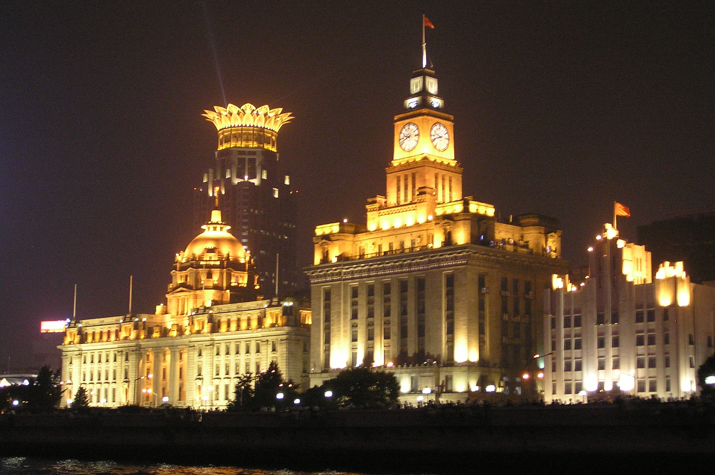
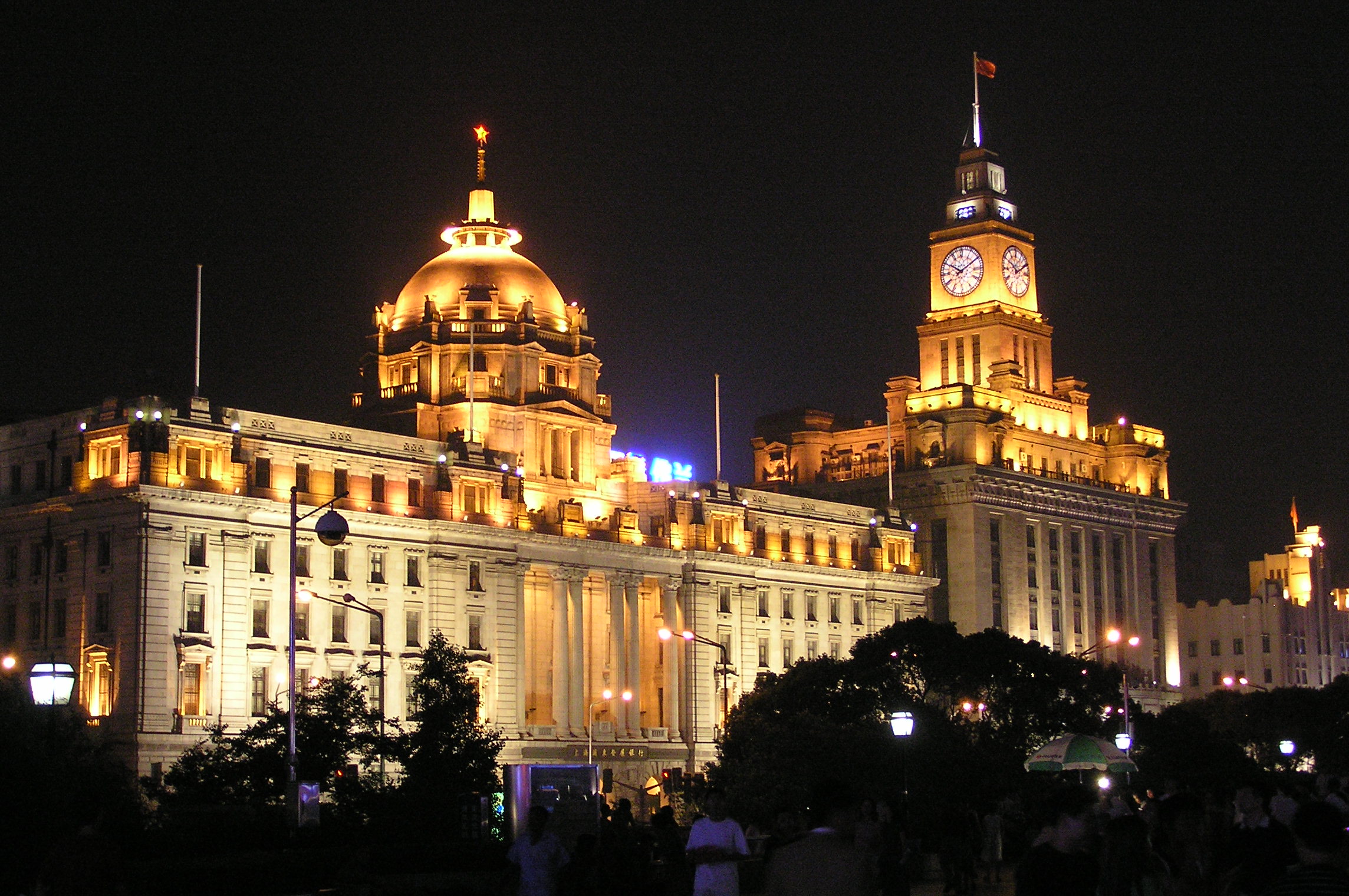
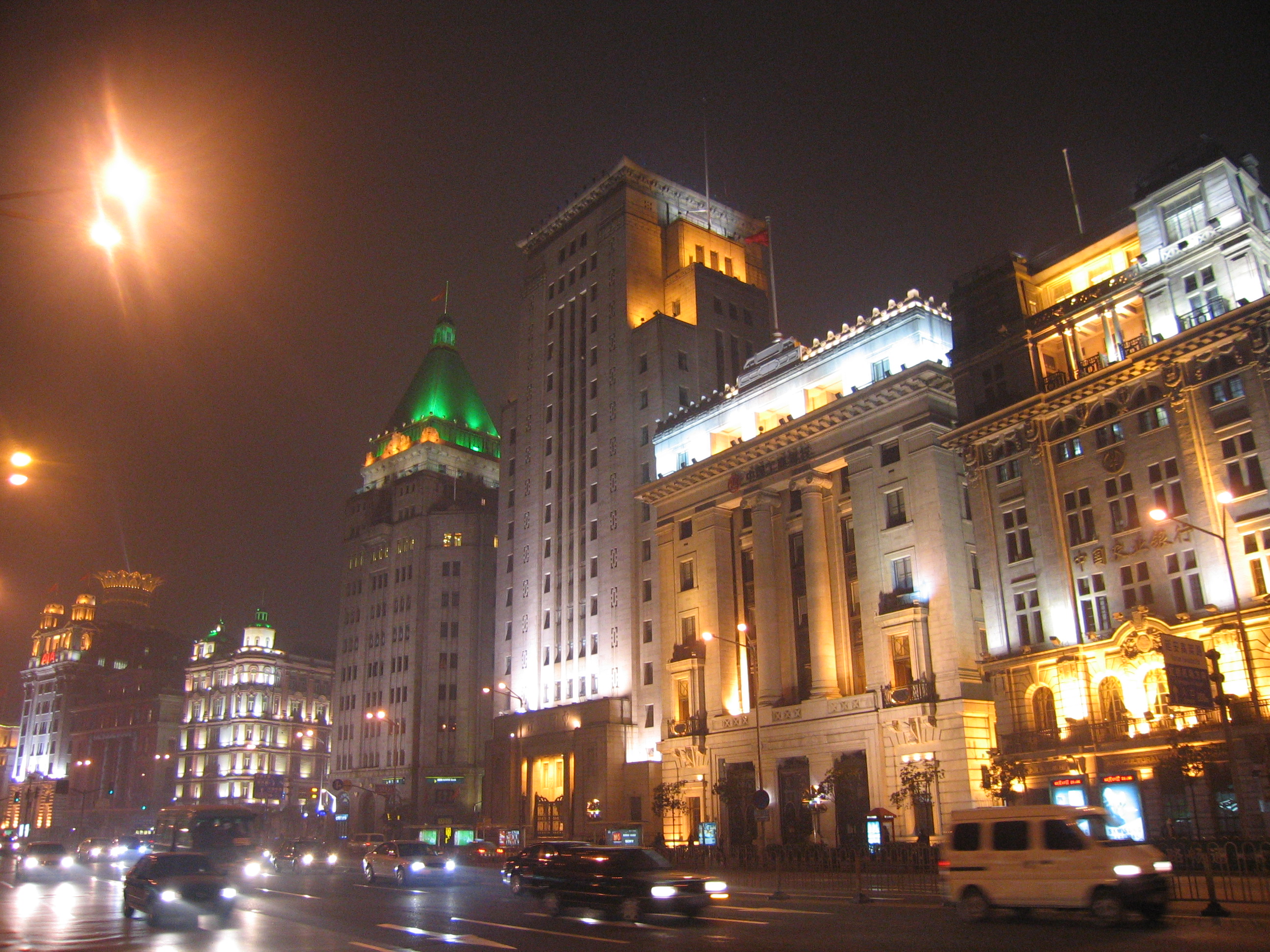
| | | | Find Jing'an left of center, and click to enlarge. Yan'an Road stands out, and the Equatorial Hotel is named, but actually stands right at the intersection with the side road. You can see the short distance north to the park and temple, and then south into the leafy streets around Changle Lu (Road) leading to Huaihai Lu. While it's not the neighborhood around the Bund, it's not half bad. | | | | The next day, bright and sunny, was Day 6 of the group trip. While we had three nights in Shanghai, we had only two full days, and one of them included a factory visit. I was fearful we wouldn't get to see much, which is one reason I tried to see some of the French Concession the night before. I had nothing to be afraid of. The two days were among the best of the whole trip, and we saw everything I wanted to see. There was so much to see and discuss, that our second day will be discussed on the next posting. | | | | But again, like children we were kept in the dark. It wasn't clear what we'd be doing, pretty much until we did it. I don't know if that bothers you, but I don't like it. Still, it worked out. We were to start with the factory visit, and also had no idea where the factory was, or how we'd get there. Was it in town, so we'd just take our bus? Was it out of town? These are the frustrations of group travel. | | | | Well, it was out of town, and we would be taking the train, and to be sure, out of Hongqiao Station, so we got on the expressway in front of the hotel and went west about 20 minutes to the combined station and airport. Follow that on the map, except that it seems to be a few years older than the previous map, so, while the airport is shown there, metro lines are still being planned to reach it, and Hongqiao Station hadn't been built yet. | | | | Well it WAS built in 2010, and, unlike downtown stations, it has huge, airport-sized parking lots around it, which shouldn't surprise anyway, since it's located right at the airport. It's the largest railway station in Asia, blah, blah, blah, but check again tomorrow to see if it still is. As I said about Guangzhounan, all these new HSR stations are modern and efficient, but they do look like airports, and to be sure, this one is, again, right at an airport. If you can't tell one airport terminal from another, it's the same here. So instead, let's look at the station's waiting room inside (Photo by Patrick Nagel) to asses the station's size, and it is formidable (click), and airport-like. Again you can see the security inspection in the foreground that exists in all stations in China. | | | | It had been planned that we were to go see the operations room at the station, but it didn't work out. Instead, we'd see the one at the station where we were going for the factory visit. And where was that? In Souzhou, where we'd passed through the afternoon before coming from Nanjing! I really don't like being kept in the dark about things like this. We proceeded to the platform level (Photo by Patrick Nagel). I'm not sure what platform we left from, but click to see that the train on Platform 25 is headed for Nanjing, so Suzhou would be on the way. And it wasn't a very long ride, since we were now on the high-speed route. | | | | At Suzhou Station, we were taken to see its smaller control room, but it was no big deal at all. We were picked up by factory buses, and I wondered why the station area seemed so suburban. Were we really in a city? Only when writing this posting did I have access to the regional rail map at the beginning of this section and only then did I realize that we weren't in the same downtown Souzhou station I'd noticed the day before, but at Souzhou North. I found out when back in Shanghai that Suzhou is known for its canals, stone bridges, pagodas, and particularly for its famous Chinese classical gardens. The gardens are UNESCO World Heritage Sites, and Suzhou is known as the Venice of the East, and also of China. But we saw none of that, not even the downtown area. Seeing the city wasn't a planned stop either, so I'm resigned to that, but it's odd to plan a factory tour (and lunch) and not get to see just a wee bit of what the city is known for. | | | | The "factory" tour was pleasant, particularly since it didn't seem like a factory and was more like visiting a science museum located in the midst of a green campus. It was the Easyway Software Company, and, as we got off the buses, we were greeted by the man in charge, who was ebullient about his company. He had lived and worked for quite a while in Naperville near Chicago, so he spoke English quite fluently. The company made ticket-entry systems, things like the Octopus Card in Hong Kong, or similar things everywhere, also the turnstile devices to allow entry to rail and metro stations. The "museum" was actually his showroom, meant to show his merchandise to clients, and was rather interesting. But his hour-long tour was sufficient. His buses then took us to one of those wonderful lunches we'd been having, this one in a very nice restaurant in a park area. I think only then did I figure out something else that had been kept from us as the trip had been planned. I assume that we were prebilled for most lunches in the itinerary when we paid for the trip, but now think that the organizers had arranged for the factories to treat us to meals as a courtesy, as VIP clients. It also clarified what had gone wrong on that excursion I had skipped in Guzngzhou where it was realized at the last minute that no lunch would be provided, and those that went were on their own. | | | | As we were leaving the restaurant and boarding the buses to the station to go back to Shanghai, we had another pleasant surprise. The factory owner's assistants came out of the restaurant holding armfuls of colorful cardboard boxes, and one was given to all two dozen of us. What a pleasant thought, even though it was just a trinket involved. The trinket was a framed Chinese embroidery, something China is known for. I'm sure they were machine sewn, but were nice enough, and it was particularly the thought that counts. There were several different designs, which we noted as we all took them out on the bus to the station. Some were rather silly, but I liked one that showed a beautiful blue-and-white vase (it would have been my second choice). But I was most pleased with the one I got. My embroidery, which now hangs in my kitchen, was of a beautiful park scene with a brook and trees. While there is some green and yellow in the background, most of the trees have bright red leaves, since it's autumn. The minute I saw it, I was reminded of the Nanjing guide at the Ming tomb who had said the park there would have cool weather and colorful autumn leaves if we'd visited one month later, in October. So, when I think of the hot China weather I experienced, I also think of my embroidered cool and colorful autumnal park. | | | | On the return in the mid-afternoon, we were informed by the Shanghai guide about another extra, for an extra charge. I had passed on the Guangzhou cruise and the acrobats, but was elated about what he was describing for the rest of the day, a visit to both the French Concession and an evening cruise on the Huangpu! This was wonderful! I didn't mind paying the extra charge, but I still wonder what the trip planners were thinking about for us to do during the rest of this afternoon and evening. Missing Shanghai with only one more day there? I'll be generous and give them the benefit of the doubt. Maybe they thought the factory tour would have lasted longer. But we'll never know, will we, since we Kindergartners were never in on the planning and were never told anything in advance. | | | | One other thing: I'm going to do what I did at the Ming tomb for these two spectacular stops. First I'll describe what was shown us, and then I'll give MY tour. Which do you think you'll prefer? | | | | It was already late afternoon and dimming outside when we took the bus along the expressway to a point in the French Concession perhaps 1/3 of the way east of the river. The bus drove us south across Huaihai Road and dropped us off. We walked through a charming pedestrian district with sidewalk cafés, and many older buildings and villas. We then walked to a very interesting-looking building that was now the Museum of the First National Congress of the Chinese Communist Party, held in 1921, and then went back to the bus. It was a very pleasant walk of about 45 minutes, and at the end we'd seen a very nice, laid-back and historic neighborhood. And we knew nothing about it, beyond that it was part of the French Concession, not even its name. | | | | My tour: During this stop, I had only the vaguest idea of where we were. Only when writing this posting and inspecting our above "sights map" did I find the location. Go along the expressway from Jing'an and exit south to where you see Huaihai Park on Huaihai Road (in blue). It's in the area from here and few blocks south that we walked around—you can see the Party Congress Site. | | | | I have only now, months later, found out that this delightful area is called Xintiandi (X=SH), which apparently means "New Heaven and Earth" ("tian" in the middle we already know from Tian'anmen, literally "Heaven[ly] Peace Gate"). Xintiandi an affluent shopping, eating, and entertainment district. We also have to be aware (I wasn't at the time, and no one told me) that there is a typical Shanghai-style house called a shikumen, a name that means "stone gate" (again we know men as "gate") because of the typical entrance to each house. It's a typical Shanghai architectural style combining Western and Chinese elements that dates from the 1860s. At one time they comprised some 60% of Shanghai housing, but they're disappearing, as today most people live in apartment buildings. Shikumen are 2-3 stories tall and resemble town houses (British: terrace houses) and have a high brick wall for privacy around a narrow front yard to experience nature. As townhouses, they abut each other and are arranged on straight side alleys or lanes known as longtang, the entrance to which usually being surmounted by a stone arch. The name longtang can refer both to the alley/lane that connects the houses or a group of houses themselves. The longtang form a traditional urban alley-community somewhat similar to the hutong in Beijing, which I visited more extensively, and will be described in due course. | | | | Now, while the longtang and their shikumen are disappearing, many in Xintiandi have been reconstituted as book stores, shops, cafés, and restaurants. This, including cafés with outdoor seating, is what I saw walking through Xintiandi (Photo by ヌンヌン), much of which is a pedestrian zone (click). This gentrified neighborhood didn't suddenly spring up overnight, but was developed by a Hong Kong land development company. This may sound less romantic than the spiel given to the group of the "pretty buildings" we were seeing, but it's nice to know how the area got renewed. | | | | I cannot say I had the opportunity to actually look down a Shanghaiese longtang (Photo by Gem; JakeLM) like this with shikumen townhouses on the sides—note the stonework above the doors to each house--but can visualize such an alley-community. But coming down this leafy street (Photo by Uploadalt) we came upon this building with the red stone crests. When we got to the corner, it was pointed out that that building was the Museum of the First National Congress of the Chinese Communist Party (Photo by Pyzhou), which took place in this building in 1921. We were told just a bit about it, and were just told that it was in a "historic building", and nothing more. Still, without having entered the building (no time, and it was closed, anyway), I would say that each crest surmounts the entrance to a longtang, and I found a picture that shows what we did not see, a restored and preserved longtang (Photo by verkhovensky) within the building showing the "stone gate" above each shikumen that gave rise to the name. | | | | This YouTube video runs only 1:36 and gives more of an idea of what the Xintiandi neighborhood is like. | | | | The second part of this evening add-on was the Huangpu River cruise. It was easily the most spectacular thing we did in China, and it was presented reasonably well, but not as well as I would have done, so we'll look at it both ways. You can follow it on our map of sights. | | | | From what I now know is called Xintiandi, we went back up to the expressway and, at the river, turned left to drive up the Bund. At this point, I knew that there was a tunnel crossing the river, but had no idea that there was a two-level one under the Bund. The historic buildings along the Bund were already illuminated as we moved into the evening, but we were too close in the bus to see much that was towering above us. Even pedestrians walking on the levee were a bit close; being out on the river is what turned out to afford the best view. There is an inaccuracy on the map. The Bund starts at the former Edward VII Avenue, now Yan'an Road (and expressway) and ends at Souzhou Creek. These are the exact river borders of the British Concession. This map implies the Bund runs further south. In recent years, to prevent flooding, a levee has been raised between the roadway and the river, and there's a long park along its length. The former Public Garden at the north end, now Huangpu Park, has apparently extended its name to the park on top of the levee. Perhaps this explains why the map has "extended" the Bund, but in reality, it's only the levee that's extended, not the historic buildings. | | | | We of course were not told where we were going for this cruise, or if it was private or public. It turns out we were headed for what I now know from this map is called the International Passenger Terminal to take a public boat, mixed in with many locals, which thankfully, is more authentic than doing it alone. When our bus crossed Souzhou Creek, I knew enough to want to confirm to the local guide that we were now in the ex-American Concession, and he agreed, but made the point that there's "nothing to see there". I agree that that's true, but as I commented to a woman in our group, if he knows he has two dozen Americans with him, mightn't he think that the fact that we were in the ex-American Concession be of interest to them? | | | | The terminal was very busy, but we didn't have long to wait, and shuffled with locals onto a boat. As we moved along, I found another choice piece of Chinglish posted, which I proceeded to write down: "Visitors enter the terminal please direct instructions of the staff, don't stay, don't be crowded, please caution". It's mostly understandable, but it took me a moment to realize that "don't stay" probably meant "don't loiter". Signs like this are a refreshing bit of internationalism. | | | | The main level of the boat had a large, enclosed, windowed room, with plenty of seating, but everybody, and I mean everybody, scrambled up the stairs to the open upper deck, where there were benches for maybe half the passengers. But the sights were so spectacular (pictures will follow in a moment) that people circulated, and seats were always available. We went slowly down along the Bund, then came back more on the also spectacular Pudong side, passed beyond the terminal a ways downstream, then came back. We were all quite satisfied. | | | | Returning on the bus, three blocks inland from the river we crossed the pedestrian shopping area of Nanjing Road at night (Photo by taylorandayumi) and noted all the activity. (The next afternoon we saw the same view of Nanjing road by day [Photo by Agnieszka Bojczuk]). We then drove at night down the street between People's Park and People's Square (Photo by Marcin Wichary) (click), the former recreation ground, which I'd wanted to see, anyway, not inherently, but to see how it had changed from the historic maps. | | | | To jump ahead in order to stay on topic, the last thing we did the next afternoon was to come back during the daytime, take a look down Nanjing Road again, and get off the bus on the Bund. We walked across to the levee, went up the stairs, and spent about 20 minutes in the park on the levee, looking at the river, across to Pudong, and along the Bund. It was all attractive, and I still knew nothing about what I was seeing. The entire cruise and return in the day was to see the "pretty buildings", with no further knowledge. One thing that pleased me. The customs house tower was identified to me, and at four o'clock it struck the hour. That sort of custom is SO Western, and not Chinese, that it was very pleasing to me to experience it. | | | | My tour: What is a bund? Why are these buildings here? What are the most interesting ones to concentrate one's attention on? None of this was presented, so, as usual, I've had to do my post-trip research and have now found out everything I wanted to know. | | | | We've seen the word bund used elsewhere in China, such as along the river in Tianjin. We've seen it was earlier used for other places in Shanghai, such as the French and Chinese bunds, but otherwise, when you talk about the Bund you mean the embankment along the eastern edge of the former British Concession. The word rhymes with "fund", which is a perennial problem for me, since I always want to pronounce it like the German word Bund (U as in "put") meaning "federation", as Bundesrepublik Deutschland. | | | | The word "bund" does mean "embankment" and comes from the Persian word band with the same meaning. The use of the word in China comes from the bunds, or embankments/levees in Baghdad along the Tigris. Jewish merchants and families from Baghdad settled in Shanghai in the 19C, including the prominent Sassoon family, built heavily on this embankment, and the word followed them. Persian, English, and German are all Indo-European languages, and, although any connection is not obvious, the English words, "bind", "bond", and "band", the German word Bund, and this Bund, are all related. | | | | The Mandarin name, however, is Waitan and means "outer bank", in the sense of "downstream bank", since the "inner bank" was upstream adjacent to the old walled city. The entire embankment had originally just been the location of a muddy towpath along the river. While upstream to the south, the former French Bund, the Quai de France, was similar in size to what became the Bund, it functioned more as a working harbor. Eventually, downstream in the ex-British Concession, magnificent Western-style commercial buildings for banks and trading houses from many countries were built along the road creating a major financial center for East Asia and a unique panorama along the river. The style of the buildings is usually eclectic, exhibiting, in varying degrees, these styles: Romanesque, Gothic, Renaissance and Baroque Revivals, plus Neo-Classic, Beaux-Arts, and even some Art Deco. Visually it was (and is) the epitome of Europe transposed to Asia. | | | | A wide avenue dating from the 1920s and 1930s was laid out in front of the buildings, and eventually the entire ensemble, buildings, road, and eventual levee, was simply referred to as the Bund, as seen in this 1928 picture, looking north. At this time, boats still docked here. With the levee and its park, that is no longer practical. Rather than seeing a confusion of buildings, we can start to learn from this older picture. Note three things: ● the whitish dome center left of the HSBC Building; ● to its immediate right, the clock tower (and carillon) of the Customs House—you can even see the clock; and further away, ● the pyramidal dome, which will prove to be bright green in a color picture, of what was then the Sassoon House and Cathay Hotel. You already know more than I did when I was there, when I could identify nothing. | | | | By the early 1940s, the Bund was the location of the headquarters of probably most of the major financial institutions operating in China. Let's connect that with today. When I was in Guangzhou and went to an ATM, it was an HSBC machine, and so was the ATM I used at the Shanghai hotel. HSBC is the modern corporation that developed from the Hong Kong & Shanghai Banking Corporation (HSBC). We know HK is famous for banking; the reference to Shanghai is a reference to the first domed building we just identified on the picture, still known as the HSBC Building. | | | | But similar to what happened to Saint Petersburg after the Russian Revolution, the same happened to Shanghai when the present regime came to power in the late 1940s. The financial institutions were moved out in the 1950s, the hotels, many famous, and clubs, including the Shanghai Club, were converted to other uses, including use as government buildings. The HSBC Building served as the Shanghai City Hall. Statues along the Bund relating to colonial figures were of course also removed. | | | | The decline of those years was fortunately gradually reversed in the late 1970s and early 1980s as buildings on the Bund were gradually returned to their former uses. Financial institutions and hotels returned, and the Shanghai City Hall was moved to a building in People's Square. It was at that time that flooding caused the city government to build the levee with its park, which stand some ten meters/yards above street level. The road was widened to ten lanes, and is now considered a section of Zhongshan Road. While Pudong has bristled with skyscrapers, there are none on the Bund and few nearby because of height restrictions. | | | | This a daytime view of the Bund today (Photo by Daniel Case) also from the south. You can see how wide the levee is. The street is not visible here, but is between the trees and the buildings. Note the access staircase parallel to the levee, one of which we used on that second, daytime, visit. Now let's make use of our knowledge (click). We see the dome of the HSBC Building, which in this picture is covered in green construction netting. The Custom House tower is clear enough to read the time. And now you can see that the pyramidal tower of the former Sassoon House is indeed a bright green. | | | | But if it's impressive by day, the illuminated Bund at night is spectacular (Photo by Ruazn2). Go ahead and identify all you can of what you know. | | | | Close inspection of the map shows that seven east-west streets intersect with the Bund making it eight blocks long. I've read that there are 52 buildings along it. By themselves, the buildings each have a degree of charm, some more than others. But it's the ensemble lined up along the river that intrigues the eye. And if they're attractive by day, they're spectacular illuminated at night, which is why I'm glad I saw them by night first. Even though it was a confusion of structures, all forming a continuous blur, I enjoyed the experience, by night and by day, immensely. But now, with the knowledge of hindsight, I've been able to review the buildings, and will point out the most interesting, first individually, then in groups by day, then at night. | | | | Because of its prominence, we have to start with a building that is NOT on the Bund, but that does add to its character. Starting in the south, two blocks inland from the first block of the Bund is a complex called the Bund Center (2002), which includes 50-story tower rising 198 m (650 ft). What impresses most about the building is that it's surmounted by a crown, which is illuminated at night so it appears golden. This is a river view that includes the Bund Center (Photo by Paul Louis). Behind a typical river freighter (click) is the crowned tower, and you can get a dark but decent view of the buildings of the Bund from their obvious beginning and covering the first four blocks of the Bund up to two buildings you already know. Day is nice, but night is better in this view of the Bund from Pudong (Photo by Ctny). You can see what I mean about the crown, can find our two buildings again, and can see the variety of cruise boats. | | | | Now for the individual details of selected buildings, something I did not have at the time. Moving northward, the third block starts with what by now is an old friend, the HSBC Building (Photo by Diomidis Spinellis), a 1923 six-floor structure in neo-classical style. It was HSBC headquarters from then to 1955. With the city hall now having moved out, it's a banking building again, but houses the Shanghai Pudong Development Bank. (Some things never change.) In this view across the levee, don't let that building in the right background confuse your enjoyment of the classical symmetry. | | | | We already know its neighbor, also on the third block, the 1927 eight-story Customs House (Photo by Diomidis Spinellis), with its iconic tower and bells. It and the HSBC Building serve as the symbols of the Bund and of Shanghai. It remains a customs house. (Some things REALLY never change!) | | | | But I see this set of buildings as a trio. The former China Bank of Communications Building (Photo by Ferox Seneca) is across a narrow side street from the Customs House (on the left) and on the fourth block of the Bund. Completed in 1948, it was the last building to be built on the Bund, right before the government change. It's distinctive because it's an Art Deco building, put up right at the tail end of that architectural period. It's no longer a bank, but houses the Shanghai Council of Trade Unions. | | | | Now let's put our first grouping together. Here's the trio of buildings (Photo by Mr Tickle) we've been talking about. You can even see a bit of that "crown" peering out behind the Customs House tower. And of course we need the same view at night (Photo by Mr. Tickle). You can see why it's worth including the nearby Bund Center in this discussion. Finally, because it, too, is so nice, a view from another angle (Photo by Mr. Tickle). It's hard to get a bad view here. | | | | Let's move to another section of the Bund that's particularly noteworthy. This is the point where the fifth and sixth blocks of the Bund straddle Nanjing Road, before it gets pedestrianized further inland. The two buildings in very different styles we see together form today the Peace Hotel (Photo by Livelikerw), yet act as two different businesses, both bearing the Peace Hotel name (click). On the left, the South Building was built as the Palace Hotel in 1908 in the Renaissance style and is today the Swatch Art Peace Hotel. When built, it was the tallest building on Nanjing Road. The North Building, the larger building on the right—and we now get to our pyramidal green roof—is today the Fairmont Peace Hotel, run by the Fairmont Hotels of Canada. | | | | This building was built in 1929 as Sassoon House, built for Sir Victor Sassoon of the famous Sassoon family mentioned earlier, who possibly brought the word "bund" here from Baghdad. Half of the ten floors housed Sassoon's business interests as well as outside companies, and the top floor originally housed Sassoon's private bachelor apartment. But the other five floors housed the prestigious Cathay Hotel, with a ballroom, restaurant and night club. The steep pyramidal roof, about 10 meters/yards high, originally had a large dining hall. Before 1949, the Cathay Hotel was regarded as the most prestigious hotel in Shanghai. Noël Coward wrote his famous play Private Lives in the Cathay Hotel. And one more thing. The pyramidal roof is faced with copper, which has oxidized to green, which is also why the Statue of Liberty is green. | | | | We need a nighttime view (Photo by Anthony Hartman) of this final grouping. Click to enlarge to appreciate the Bund Center at the far left in the distance, followed in the foreground by both parts of the Peace Hotel straddling Nanjing Road—the green pyramidal roof shows up particularly well under illumination--as well as other Bund buildings to the right. And to bring it all together, we have this panoramic view of the entire Bund at night (Photo by Jhong). Click to enlarge to identify all the buildings we know. This panoramic view is either from Pudong or from a riverboat similar to ours. On the right side, the Bund ends at a dark Souzhou Creek coming towards us into the Huangpu, and a bit of the former American Concession is also visible. | | | | When one turns around from facing the Bund, one sees Pudong and its skyscrapers. The view is nice at night, too (see following video) but here I only have a daytime panorama of Pudong (Photo by Yhz1221) (click). The wide-angle lens makes the river look U-shaped from here, but it's actually only a right-angle turn. Look what's happened to the Pudong rice paddies. Pudong is a financial and business center, home to many skyscrapers including the 1994 radio and TV tower called the Oriental Pearl Tower (Photo by airunp). | | | | As we leave the river, take a look at this YouTube video (2:59) showing the River cruise at night as we saw it, and the levee at night, but which we walked in the daytime. | | | | | | 0:00 – Starts with Pudong at night, but then shows the Bund. If you followed the above, you'll recognize a lot more here than I did at the time.
1:50 – Excellent iconic view, and we hear the Customs House Tower bells ringing!
2:04 – Looking down the beginning of Nanjing Road (not pedestrianized here), with the Peace Hotel on both sides.
2:27 – HSBC Building with the Bund Center peeking out behind, then the Custom House Tower.
2:42 – The ideal lengthwise view from the south.
|
| | | |
| |
|
|
|

