|
Reflections 2014
Series 2
February 6
China X: Guangzhou II: Salem & Canton's 13 Factories - Shamian Island
| | Salem In the summer of 2011, as part of the New England Thrice trips, I spent a few nights in Salem, Massachusetts, and spent July 19 walking the town. Salem is associated with the witch trials and with Nathanial Hawthorne and his House of the Seven Gables, but what I was most impressed with on an international level was the history of Salem as a world seaport as represented by the Salem Maritime National Historic Site. I suggest a review of 2011/20, using Ctrl-F to reach "Maritime Salem"), although I'll summarize a few main points here. | | | | | | Merchant shipping saw extensive growth in Salem as an outgrowth of cod fishing. Over time, almost 1,000 ships were launched out of Salem. During the American Revolution, Salem shipping grew further, and with the experience that Salem captains and merchants gained, after the war they expanded into world trade in all sorts of merchandise to many ports. In 1786, Elias Derby, the leading Salem merchant and shipper, sent his Grand Turk out of Salem, and it returned from China with luxury goods. Asian commerce was referred to generally as the “China trade”, and made Salem enormously wealthy, as evidenced by the fine sea captains' and merchants' homes in Salem's historic districts. The taxes (tariffs) paid on imported goods supplied 95% of the US federal budget in 1792, and the port of Salem was a major contributor. In 1790, Salem was, per capita, possibly the richest city in the United States. Salem’s ships were so common in ports around the world that some thought Salem was a country. By 1790, Salem was the sixth largest city in the US, and a world famous seaport, particularly because of the China trade. |
| | | | That Salem posting has illustrations of historic Derby Wharf, with a replica of a historic ship that would have been used at the time, and of the old Customs House, describing the museum display of the large variety of wares that would have been stored in the warehouse behind it for taxing and transshipment during the time of the China trade. I've also found a new contemporary picture of the port of Salem in the 1770s, just as the period of the China trade was taking off. | | | | With stars in my eyes standing at Derby Wharf, visualizing far-away places, particularly the China trade between Salem and what was then known as Canton (Guangzhou), I hardly expected to be in Canton itself just two years and two months later. Yet so it came to be. | | | | The Canton System In this account, we'll call Guangzhou (the endonym, or local name) by its traditional international name, the exonym Canton (Kanton, Канто́н, Cantâo) since that's the name it was known externally by during the period of history we're discussing. And of course, the local language and cuisine are still called Cantonese—nobody calls them, internationally, anything like "Guangzhouese". | | | | Centuries after China traded with the West along the routes of the Silk Road, the Portuguese settled Macau in 1557, which was the beginning of the 17C and 18C maritime period of international trade with China. From that early period on, China tried to restrict European trading to Macau, but in 1683-4, the Qing government gradually relented restrictions on foreign trade, and the Emperor allowed foreigners ("barbarians") to trade with China in four cities, including Canton/Guangzhou. Canton became the preferred port for most foreign trade, but its location at the head of the Pearl River Delta was in its favor, as well as its long experience in balancing the requirements of the Beijing government with the needs of the merchants, both Chinese and foreign. | | | | By 1686, Westerners were also allowed to live in the trading houses in Canton, which was a major advancement for them, and a major concession for the foreigner-wary Chinese. Originally, foreigners could trade in the trading houses in season only, and couldn't even be in China at all in the off-season. Then they were allowed to stay in Macau in the off-season. Finally, they were not only allowed to use the trading houses all year long, they were also allowed to live in them. But this slow progression shows the ongoing wariness of the Chinese toward foreigners. | | | | By 1757, the Emperor limited Westerners to Canton alone, and nowhere else. The Portuguese from Macau, the Spanish in the Philippines, Arabs from the Middle East and others had already been trading in Canton by the 1690s. The French and English joined them, as did Dutch groups in 1717 and 1729, Denmark in 1731 and 1734, Sweden in 1732. Two later arrivals were the US and Australia. The first ship from the US arrived in 1784, and one from Australia arrived in 1788. If that last date makes you feel as incredulous as it made me, you're in shortly for the same surprise I had. | | | | The Canton System was extremely profitable to three groups. The (1) Emperor and his government received both customs payments and a large fee for giving a monopoly on all foreign trade to a group of (2) Chinese merchant firms, which formed a merchant guild, or hong (hang in Pinyin) to trade with Westerners. The Westerners knew this guild as the cohong, a word derived from gonghang, meaning "officially authorized merchants". As a sign of the Chinese government's wariness of foreigners, the cohong had to guarantee every foreign ship coming into the harbor and take responsibility for every person connected to the ship. Finally, the (3) foreign merchants and their companies made fabulous profits. Some of the young men that served in the Canton trading houses arrived at the ages of 16-20, and went home after a very few years as wealthy men, having founded international trading companies that in some cases long survived them. These men sound a little like the dot.com entrepreneurs of the era. | | | | Canton with its trading houses were by then one of the world's great trading ports, and what, according to my guess, could have been compared to a "world trade center" of the era. Canton maintained this distinction until the First Opium War, a result of which was the opening of other Chinese ports to world trade in 1842 (more below). | | | | This unique privilege that Canton had made it the third largest city in the world by population in the year 1800 (note that at that time, seven of the top ten world cities were in Asia, the remaining three in Europe): | | | | | | 1) Beijing 1,100K; 2) London 861K; 3) Canton/Guangzhou 800K; 4) Edo (Tokyo) 685K; 5) Constantinople (Istanbul) 570K; 6) Paris 547K; 7) Naples 430K; 8) Hangzhou [SW of Shanghai] 387K; 9) Osaka 383K; 10) Kyoto 377K |
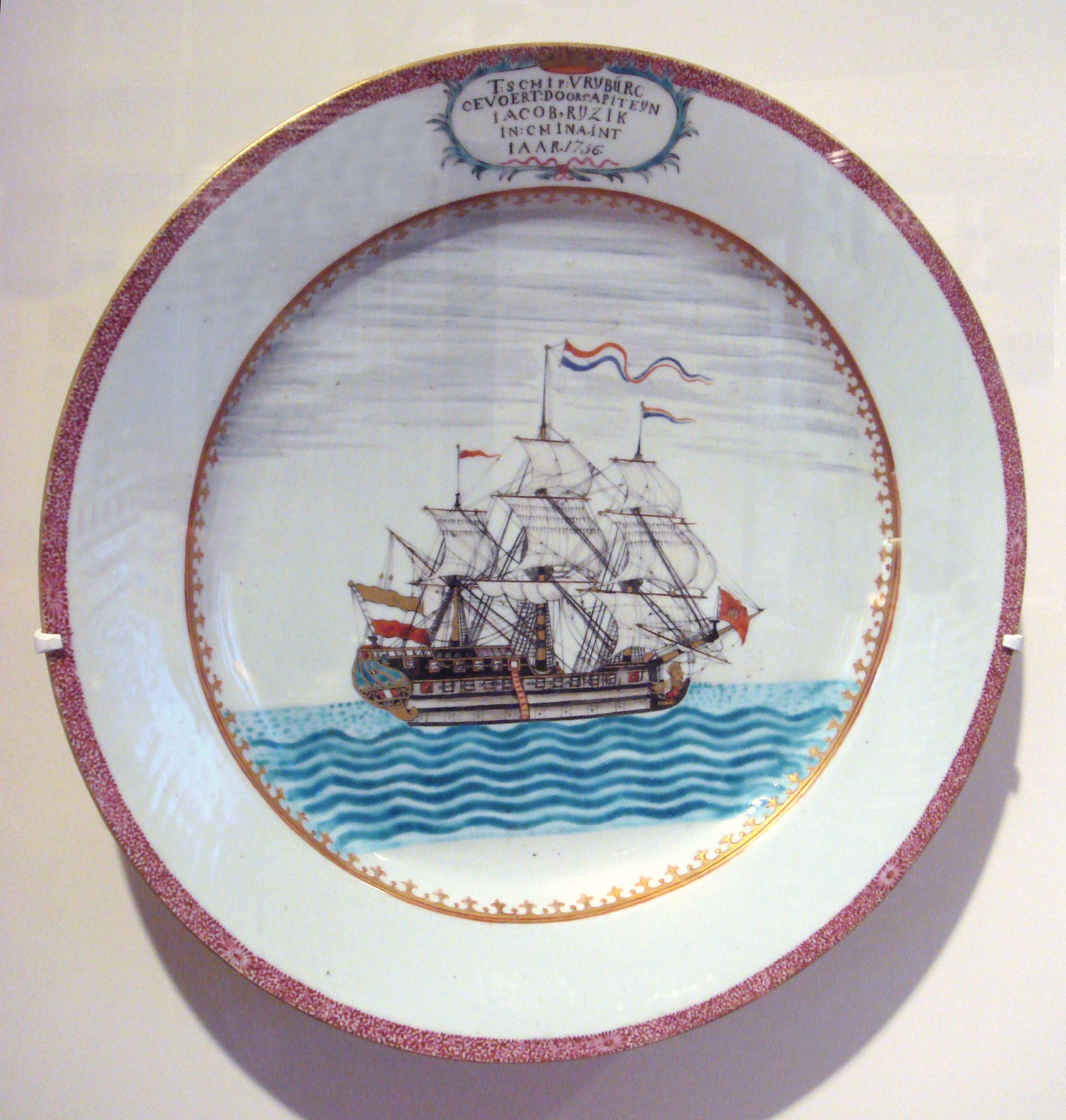
| | | | The period of Canton's uniqueness as THE trading port for all of China, the 8½ decades from 1757, when Canton was declared the only port, to 1842, when other ports were again opened, is referred to historically as the Canton System of regulating foreign trade. The Canton System was China's attempt to control and regulate trade with the West within its borders. Seen from the foreign point of view, it was a complement to the China Trade. | | | | China Trade Also known historically as the Old China Trade, the China Trade was an external reflection of the Canton System of trade used within China. While many European nations had been involved in their own China Trade for decades, while the US was a British colony, it was absolutely forbidden to trade with China, that right being held by a group of British merchants known as the East India Company. But once the US was independent, it was free to trade with China, and the first American ship to do so was the appropriately named Empress of China, out of New York, which arrived in Canton in 1784 and returned with a very profitable cargo largely consisting of tea. (The above-mentioned Grand Turk arriving in 1786 was the first ship in Canton out of Salem.) | | | | The other latecomer to trade with Canton was, as mentioned earlier, Australia in 1788. But how could that be? That must have been a misprint. It was just in 1788 that the First Fleet arrived in Australia with the very first settlers. How could they go right into maritime commerce that very same year? | | | | I couldn't believe it, either, so I set out to check, and the result was one of the more interesting outcomes of this story. Online sources weren't getting me the answer, so I decided to go right to the horse's mouth, as it were. I went to the website of the National Library of Australia and played around with that for a while, feeding in words like "China" and "Canton" and that led me to the website of the State Library of New South Wales, which is actually the oldest library in Australia (Australia originated in NSW), and this is what I found out, put in sequence with the earlier history. | | | | For a fuller description, go to 2010/11, then Ctrl-F "First Fleet", but the essentials are these. What is known as the First Fleet was a group of 11 ships that left Great Britain on 13 May 1787 with settlers, many prisoners, for Australia. The fleet consisted of two Royal Navy ships, three supply ships, and six convict transports. One of these convict ships was the Charlotte. After the fleet attempted an unsuccessful landing in Botany Bay (the next inlet south of today's Sydney) the ships swung north and pulled into what is today Sydney Harbour, officially called Port Jackson. They turned to its south shore and into Sydney Cove, the heart of today's city. The fleet, including the Charlotte, arrived in Sydney Cove on 26 January 1788, a date celebrated now as Australia Day. | | | | The fleet had accomplished its mission, and the ships scattered to various fates. The information from the Library pointed out that the Charlotte left Sydney some months later on 6 May 1788 under charter to the above-mentioned East India Company stopping in Canton to take on a cargo of tea on its return to England. The East India Company was a major player in Canton and carefully guarded its shipping routes, including its newly established Sydney-Canton one. Still, it's hard to imagine, though true, that commerce with Canton took place within months of settlement in Australia. This commerce grew quickly. American vessels, including the Hope in 1793, started to stop in Sydney on the way to Canton, and by 1798, English merchants in India also broke into the East India Company's monopoly and started trading between Sydney, Canton, and India. By the second decade of the 1800's, Sydney traders had arranged lucrative shipping deals of cargoes involving India and Canton suppliers. | | | | Curious about the fates of the other ten ships in the First Fleet, I found that two others were also involved with Canton. The Lady Penrhyn was under contract to first go to northwestern North America to trade in furs, then to go to Canton to trade them for tea and other cargo. However, she left Sydney on 5 May, but only made it to Tahiti before having to turn around. On 19 October, she did stop in Macau on her way to Canton to pick up a cargo of tea. The Scarborough left Sydney with her on the same day, but the source only says she "went to China". In any case, the Australian connection to Canton did seem to start with a bang, having direct connections with the First Fleet that initiated the colony. | | | | Chinaware We know that major cargoes out of China were silk (going back to the days of the Silk Road) and tea, which has been mentioned specifically several times, but we should not forget the third member of the popular trio, porcelain. Simply put, porcelain is a high-quality type of ceramics, for which the Chinese have always been noted, and which other countries have tried to duplicate. | | | | The English word comes from French porcelaine which comes from Italian porcellana. Most languages use variations of the word: GERMAN: Porzellan; DUTCH; porselein; SWEDISH: porslin. The Italian word means "cowrie shell", based on the lustrous transparency of this ceramic and its similarity to the inside of sea shells. Perhaps we should stop there, but I'll go for broke and get piggy: the Italian word is based on porcella, or "sow", based on the seashell's supposed resemblance to female pig genitalia. I'd like to know who it was that first put those two images together. Is that more than you wanted to know? Anyway, the next time you see pork served on porcelain, know that the two words are related. | | | | Back on course. English, however, seems to be the only one of these languages that uses an alternate word, and, as a matter of fact, more commonly so. Your dishes can be porcelain, or, in English, they can be china. Amazing. Figurines, on the other hand, are always "porcelain", only tableware porcelain can be "china". English uses "porcelain" in a more exotic, upscale sense, and "china" in a more everyday sense, to describe the same thing. | | | | But do be amazed. Can you think of any other country whose name is used as a product? We keep our china, also known as chinaware, in a china closet, so very connected is the concept of porcelain tableware with China. The closest I can come up with is not a good example: Danish pastry is shortened to Danish, but that's the adjective form, not the name of the country. We don't say we're having *Denmark and coffee, do we? But that's a thought to consider the next time you have Danish on china. | | | | We use the word "china" so commonly that the term has even come to include everyday dishware. Therefore, we have to say "fine china" when we're actually talking about porcelain dishware. This stepping-down of a word's meaning from fancy to everyday is not rare. Consider words like brassware, goldware, silverware, each one designating objects made from that metal. Only the last word has shifted meaning considerably. Referring to "silverware" no longer includes silver teapots and silver trays, it only includes silver cutlery when you say you're putting silverware on the table. And then the word suffered a denigration of meaning from fancy to everyday just like "china" did. Today, "silverware" has moved down from meaning "silver cutlery" to just "cutlery", which, more often than not, isn't even made of silver. Worse still as to loss of meaning, "silver" alone can refer to cutlery, made out of anything. The most extreme example I can think of is really quite common, the expression "plastic silverware". | | | | In addition to Chinese domestic chinaware being sold through the Canton System, a foreign market also developed. Some of it was done on spec, where Chinese artisans would decorate porcelain with generic foreign scenes for foreign sales, and some of it was done to order. This porcelain is known as Chinese Export, and, as anyone who watches Antiques Roadshow knows, as valuable as period Chinese porcelain is, Chinese Export ware is even more prized. Generically, there could have been pictures of European royalty on the porcelain, or perhaps someone commissioned a representation of his manor house by sending a painting to China to be copied. For instance, this is a Chinese Export porcelain plate from Canton made for a Dutch sea captain (Photo by World Imaging) of the ship Fryburg in 1756. | | | | And this is an example of Chinese Export ware c1810 made for the American market. Since the American Eagle with stars, a popular motif and highly prized today by collectors today, was generic, it doesn't seem to have been a specific commission. | | | | Perhaps the most spectacular of the known Chinese Export ware are the two Sydney punchbowls that include early hand-painted scenes of Sydney dating from before 1820, just three decades after the founding of Sydney and the start of its commerce with Canton. Both punchbowls rose from anonymity within the last century and are of Cantonese origin. One of them was presented to the above-mentioned State Library of NSW in 1926. It had come back to Sydney via London. The second, similar one, came back to Sydney 80 years later, in 2006, by a route that included the Newark Museum in New Jersey USA, and resides in the Australian National Maritime Museum. It's been suggested that the two bowls were commissioned by two different early government officials of NSW in the first years of the 19C, but there is little proof of this. Apparently it's relatively common for the Canton trading houses, or hongs, to be illustrated on punchbowls, items that were in common use at the tie, but is exceedingly rare for ports that traded with Canton, such as Sydney or New York, to appear on punchbowls. | | | | The two bowls are very similar, but not exactly the same. Although the inner centers of both bowls are identical, showing an indigenous Australian group, the outer sides, which both show panoramic views of Sydney Cove are not. The Library one shows the view from the east (where the Sydney Opera House is today) and the Museum one shows the view from the west (where the Sydney Harbour Bridge is today). Showing two opposite views of the same thing such as this was apparently typical for the period. All the above would have been done from illustrations presented to the artisans by the persons commissioning the works, but the decorative borders and trim would have been left up to the painters. | | | | I'd like you to look at two pictures I've chosen, both of the Library punchbowl. Both photos are by the State Library of New South Wales, and it's unclear if I'm allowed to link to them directly, so I'll ask the reader to copy and paste each link in a separate window:
http://upload.wikimedia.org/wikipedia/commons/4/46/Sydney_Cove_punchbowl_side_and_inside_view_a281005h.JPG
http://upload.wikimedia.org/wikipedia/commons/8/88/SLNSW_Sydney_Cove_panorama_with_numbers_%28high_res%29.pdf
| | | | Just the one bowl can give an excellent idea of these works of art. The left picture is of the Library bowl, showing the continuous Sydney scene on the outside and the floral decoration on the upper outside and inside. Not visible is the black-and-white aboriginal scene on the inside bottom. The right picture adds history to art; it shows the detail of the Sydney view to the west over Sydney Cove, which is the more interesting of the two. Move your cursor to the bottom until the plus and minus signs appear, and hit the plus sign to enlarge. On the left is the remnants of the worn-off monogram, perhaps of whoever commissioned the bowl. The yellow structure at Point 1 is where the Sydney Opera House is located today. The beach at the left is the present location of Circular Quay, with all its ferries. On the opposite side, on the right, is where the Sydney Harbour Bridge is located today. This is not only a very early view of Sydney Cove, it also shows the importance that Canton had already taken in Sydney life. | | | | Factories I've been discretely and judiciously using the word "trading houses" for the facilities in Canton up until now to avoid making you as confused as I was when I first saw the real word, "factories". Factories? How were these offices factories?
| | | | The word "factor", when applied to a person, means "doer", in other words, "he who does [something]". Look upon a factor as a "facilitator". A factor is therefore an agent, or a trader. Now what do you call their offices? A trader is in a trading post, an agent is in an agency, and a factor is in a factory. | | | | The confusion involving this concept exists only in English, which is defective in having a more sensible word. Presumably "factory-1" meaning "agency" developed into "factory-2" meaning "place of manufacture", or "place of fabrication". Notice that last word, which is the form other languages use for the second meaning: FRENCH: fabrique; GERMAN Fabrik; DUTCH fabriek; SPANISH fábrica, and more. Therefore, when German talks about a Faktorei, Dutch about a factorij, and Portuguese about a feitoria, there's no confusion between the two concepts, since the words are entirely different. Only English uses "factory" to cover both concepts. An image that comes to mind is the well-known street on the waterfront in Savannah, Georgia, called Factors' Walk, which runs along the front of the former factories/agencies there. | | | | Most cities in the world started as factories in the first sense. As the Phoenecians, Greeks, and Romans spread across the Mediterranean, the settlements they founded also involved trade with the home country, and therefore a factor with a factory. This was the case with Venice, Naples, Rotterdam, New York, Shanghai, Lisbon, and others. They also flourished during the Hanseatic League, which was founded on trading, and therefore had factories all across the Baltic. The factory in each settlement served as market, warehouse, and perhaps customs house. | | | | But in English, we rarely use the word "factory" in this sense, because of the confusion. The one instance that comes to mind is the York Factory in Manitoba on Hudson's Bay. When I was in Churchill (2011/27-28-29), I noted on the map that the site of the York Factory was on the southwest shore of Hudson Bay about 200 km (120 mi) southeast of Churchill. The Hudson's Bay Company functioned at York Factory from 1821 to 1873, and it continued to operate as a fur trading post until 1957, when it was closed down. It's now a historic site, an outpost run by Parks Canada. | | | | In the US, factories were called trading posts, and agencies (Indian agencies), but most frequently "forts". The reason for that is that legislation was often passed requiring military garrisons at the trading post, making it a "fort", even though de facto they were principally trading posts. Often the business conducted began to take on a semi-governmental nature, and today there are cities across the United States that have "fort" in their name. Some that come to mind are Fort Lauderdale, Fort Pierce, and Fort Meyers in Florida, and Fort Collins in Colorado. In many of these "forts", fortifications were minimal, and the term was used for any outpost in undeveloped territory. They were usually trading posts, or perhaps a combination of an army post and trading post. These "forts" can be pictured as early "factories". | | | | Canton's Thirteen Factories Now that we know what we're talking about when we say "factories", it's time to be impressed by the fact that Canton was of such importance in its day that it had thirteen of them. But one difference should be obvious. The factories we've been talking about had been set up in the wilderness, and were usually the foundation for a new settlement. But Canton had existed for centuries, so the Thirteen Factories (Thirteen Hongs) were add-ons to an already-existing urban fabric. Still, the factors functioned like any other agents. | | | | In sum, the factories included living quarters, warehouses, and offices for trade. The factory buildings lined up along the waterfront, each with its distinctive national flag. The British were the first to arrive, but soon after the Austrians, Danish, Dutch, French, Spanish, Swedish, and
Americans followed them. The trading quarter comprised the entire foreign quarter of Canton under the name “Thirteen Factories.” This land survey of the Thirteen Factories was taken in 1856, and was published in 1910. If you want it in a separate window, use this link.
http://upload.wikimedia.org/wikipedia/commons/3/3a/Plan_of_Canton_Factories.jpg
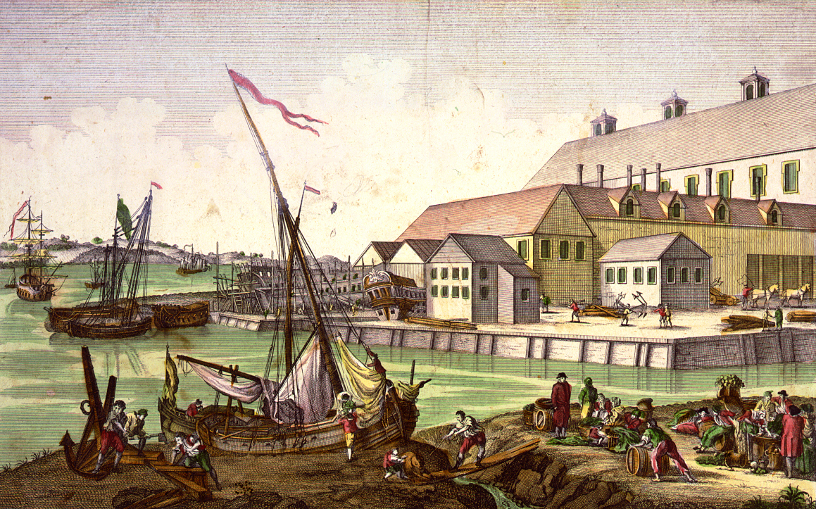
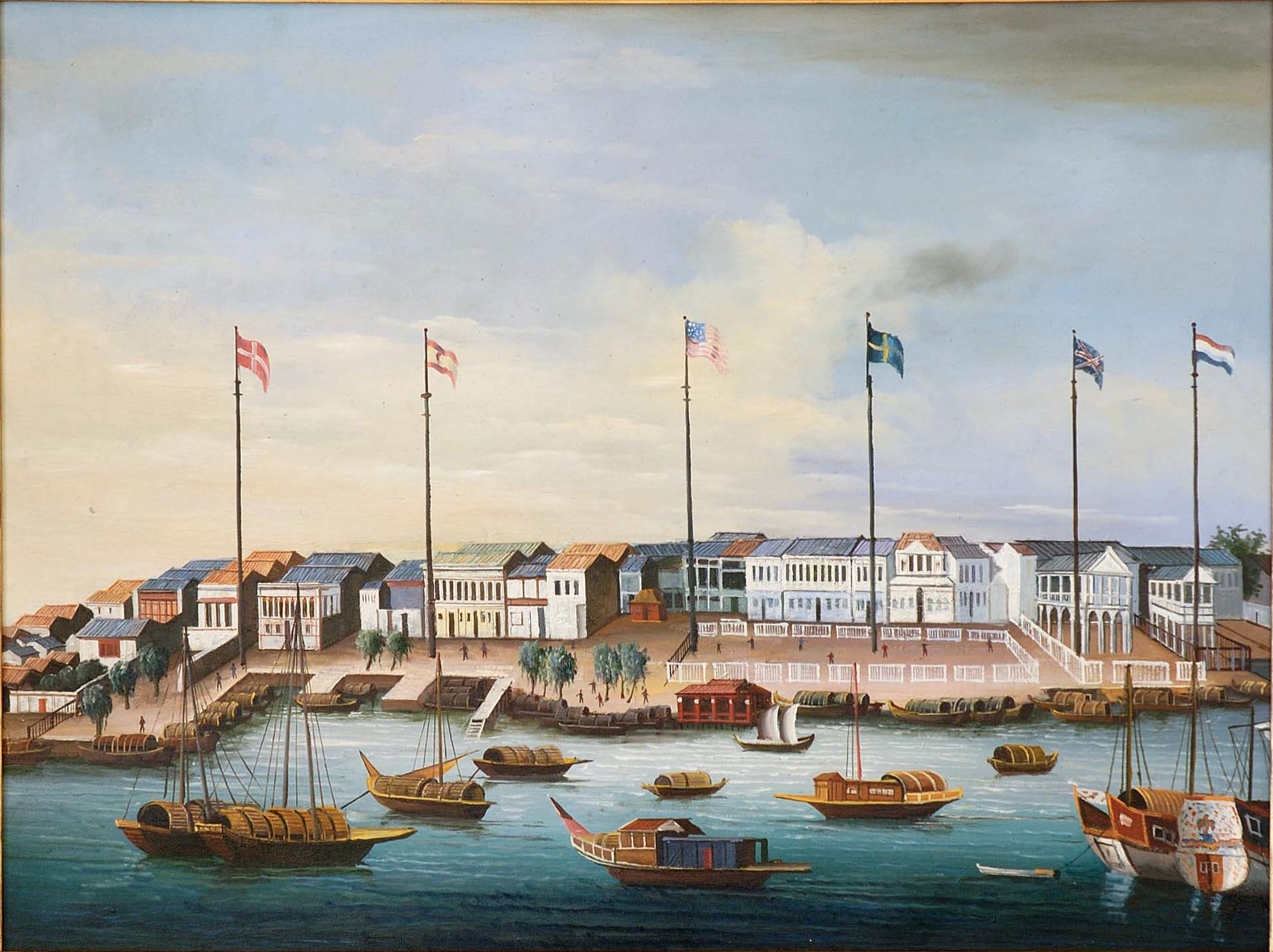
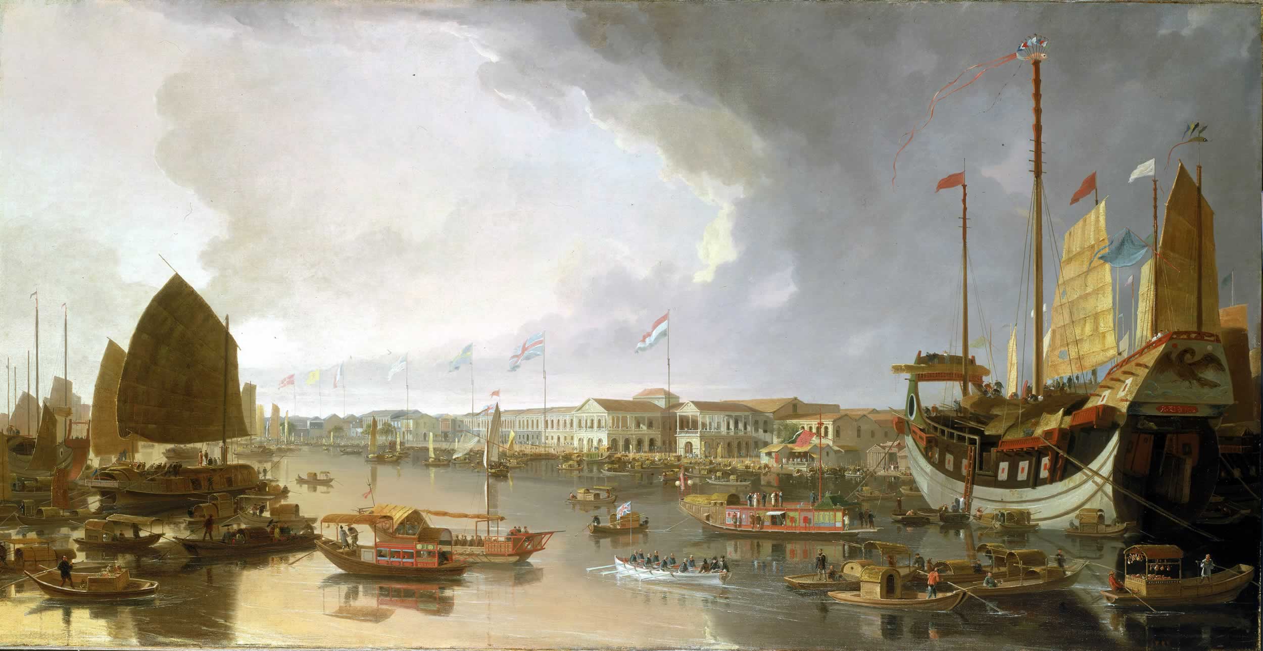
| | | | First note at the bottom that the map's on its side, with north to the right, so you can adjust to the fact that it's situated on the north bank of the Pearl River, which is located to the left. Then note on the lower right that it's 200 yards (meters)—diagonally--to the SW angle of the City Wall, a fact we'll discuss later. Most of the factories are set back from the river with two gardens between them and the water. Click to enlarge to note the names of each of the Thirteen Factories all lined up in a row. Finally, on the upper left note that the five streets have names, indicated by letters, but make particular note of the street designated by a's, which is the long main street to the back of the factories called Thirteen Factories Street (or Road), which we'll refer to again later. | | | | Both Chinese and Western artists frequently painted the distinctive facades of the factories lining the river, and the throngs of Chinese and foreign ships of all sizes and shapes. I suspect that the factories were "THE things to see" because of their foreign uniqueness. One artist showed a rather general harbor scene c1850, including the flags and gardens, but emphasizing the ships. More helpful in imagining the historic reality of the buildings is this somewhat stylized, primitive version c 1820. Even clicking to enlarge it, I can't determine what flag is second from the left, but the others are L to R Denmark, US, Sweden, Great Britain, France. The flags may or may not correspond to the survey map of the factories. | | | | These paintings may have possibly been done by Chinese artists, but are unattributed. We have two by a British landscape artist, William Daniell, that are strikingly Western, and very similar to each other. Compare his darker view with his lighter view. Both date from the first decade of the 19C, and to me, both have very Venetian qualities. The lighter one in particular makes me think of Canaletto. | | | | One more painting, from the 1850s or 1860s, probably Chinese, but I'm including it to discuss the flags. From the right, we see Denmark, Great Britain, France, the US—and what? Whose flag is red, and shows a city gate? | | | | It's not a country. It's the flag of the city of Hamburg (Image by Greentubing). If Hamburg to this day bills itself as the Hansestadt Hamburg (Hanseatic City of Hamburg), even using HH on license plates (it benignly allows the smaller city of Hanover/Hannover to use the otherwise more prestigious single letter H), why wouldn't it have had a city-to-city representation in Canton? | | | | Location of the Thirteen Factories When I was in Guangzhou/Canton, as much as geography is always very important to me, two things bothered me. Where had the Thirteen Factories been located? Even more important, where was the historic center of town? | | | | It always surprises me, and saddens me, how some people can come to a new place and either show themselves around, or be led around by others, and still have no idea where the city grew from. They see the city purely "as is", not how it might have looked "before it was updated", and least of all, how it originally looked before 20C sprawl hit it. In a case like London, where one is aware of "The City" perhaps many people realize that that's where the London grew from, but I think others just see it as just one more interesting area. I'm afraid that many visit the Wall Street financial district because it's interesting, and don't realize it's the site of Nieuw Amsterdam, whence New York grew. | | | | In China, some places are easy. It's logical that Beijing grew around the palace in the Forbidden City, for instance. Once one learns that Tianjin had a "Chinese City" before the concessions were added, one can see where the city started. Before one is misled in Shanghai to think that it grew around the Bund, one has to realize that it, too, has its "Chinese City", which was the original city. But how about Guangzhou/Canton? When we looked at the pink and yellow maps, there was no way to see where the historic center was. And I felt lost, while I was there, not knowing that or where the Factories had been. | | | | This is where post-travel research comes in. A few online clicks and all was resolved, and quite amazingly. Once one sees the older maps, the modern maps seem to have a whole new face, much how one understands people better once one has seen older photos of them. This first map is a good place to start. It shows Canton in 1860. Use this link if you want to put it in a separate window.
http://upload.wikimedia.org/wikipedia/commons/d/da/Canton1860.jpg | | | | 1860 was a turning point for Canton since it was the end of the Second Opium War, which we'll discuss shortly, and Canton was in confusion, having lost several battles in addition to China losing both wars. The map shows that historic Canton was without any doubt on the north bank of the river. The island to the south where my hotel was was still rice paddies, as was much of the area around the city. The city walls were still there—Ming walls; no surprise—and the city has expanded a little beyond them, mostly to the west, where Shamian Island, oddly spelled here, is obvious. Click to enlarge to see that the southern branch of river crossroads we discussed is labeled "Macao Passage". The city walls are curious because of the two walls on the south side. After the first wall was built, the river silted up, considerably extending the riverbank, so a second wall was built, not only to include the new area within the defenses, but also to protect against flooding. I've never seen this in a city wall before. For later reference, note the Five-Storeyed Pagoda at the north end. | | | | If you click on the upper-left area within the walls, you'll see the notation "LARGE PAGODA", which I would presume would be the Flower Pagoda of the Temple of the Six Banyan Trees (2014/1). But most revealing is the area between the walls and Shamian Island, where one sees the notation "OLD FACTORIES". Now we've found the location, which corresponds to the statement on the map of the factories that said it was 200 yards (meters) to the SW angle of the City Wall. | | | | Actually quite a bit more interesting because it's clearer to read is this map of Canton in 1910, just a half-century later. Use this link if you want it in a separate window.
http://upload.wikimedia.org/wikipedia/commons/3/33/Plan_of_Canton.jpg | | | | 20C sprawl still hadn't had much of an effect yet. All the walls are still there, and the pagoda is very visible. Although the Chen Clan Academy/Chen Family Ancestral Hall had already been built in 1894, it isn't shown; it lies due west from the pagoda, and was apparently outside the walls. Again note the Five-Storeyed Pagoda at the north end. | | | | Look at the table at the left. #10 is the British Consulate and #11 is the French Consulate, both from 1860, the year the wars ended. From then on, the Western powers didn't put up any more with being kept outside the walls, just one more indication of the eroding power of China to establish its own rules. And there we have #2, listed as the Foreign Factories, but what is meant is the site of where they had been, and #1, the Custom House. Of particular interest is the statement that the sandbank that became Shamian Island (in its alternate version, Shameen Island) had been reclaimed from the river only in 1859, indicating that it was just a part of the harbor earlier, including during the period of the Thirteen Factories. Therefore, in the previous map of 1860, Shamian Island was a brand-new entity. It was turned over to two concessions in the following year, 1861, but that story is also on its way. | | | | We need a sad word about the city walls. I've seen a statement saying how they had been a subject of local pride, mentioned back in the day in every written account by visitors to the city (including the present one). It survived, surprisingly, into the 1920's and was torn down on the orders of none other than Sun Yat-sen when he ruled the city, in an attempt at modernization. Historic preservation was not then what it is now, even in China. The space where the walls had been became wide avenues surrounding the old city—but as we've seen, it's much harder to identify the old city on a map without them. The only section of the approximately 600-year-old wall that still remains today is a stretch of about 200 meters (yards) located immediately next to the Five-Story Pagoda in that large park to the north. | | | | We now all have superior knowledge regarding the yellow map we'd been using. Copy-and-paste it again in a separate window:
http://www.travelchinaguide.com/images/map/guangdong/guangzhou-tourist.jpg | | | | Look to the right of the Shamian Island area. I think it's safe to say that Renmin Lu, in its south, central, and north sections (nan, zhong, bei) is the site of the western part of the wall. Although we can find the park in the north where the remnant of the wall remains, on this map, the Five-Storeyed Pagoda isn't mentioned. It's a little harder, but not impossible, to estimate the road (lu) where the eastern side of the wall might have been. Leaving Yuexiu Park, it might have been Yuexiu Lu. | | | | Go back to Shamian Island at the meeting of the waters, and note that, lying between the island and Renmin Nan Lu is the Guangzhou Culture Park. Any guesses as to what had been there before, and what the reference to culture is? | | | | Here's a much better modern map of Shamian Island which we'll get more use of later, but for now, copy and paste it in another window (Map by Doug Peterson). Scan your cursor at the bottom to get the plus sign to enlarge.
http://www.dpeters2.com/maps/shamian_island_map.pdf
| | | | This park is of course the site of the Thirteen Factories. It's actual name is Wenhua Gongyuan, or Wenhua Park, and it runs up to Renmin Nan Lu. As I didn't get to see the remnant of the wall, neither did I get to see this park, but I think we can all use our imagination. I would assume there's a marker, in both Chinese and English, explaining the history that took place in what is now the park. | | | | And on this map there's one other prize from the past. Note that the road running along the north side of the park is called Shisanhang Lu. Well, we know that "lu" is "road", and "hang" is Pinyin for Cantonese "hong". And Google Translate tells me that "shisan" means "thirteen", so still being used today is the historic name of Thirteen Hong Road, that is, Thirteen Factories Road, on which, back in the day, all the factories backed. | | | | End of the Canton System & the Old China Trade We said the Canton System lasted 8½ decades from 1757, when Canton was declared the only open port, to 1842, when, as a result of treaties after the First Opium War, other ports were again opened and the Canton Factories, no longer holding a monopoly, began their decline. But was that historic decline inevitable? Not at all. It was forced. | | | | Few are as much of an Anglophile as I am, but it is obvious that the huge turnaround in world trade was orchestrated by the British to their own advantage and was a rank manifestation of imperialism. When I casually mentioned in the Hong Kong posting that I'd learned in the HK History Museum about how the Opium Wars came about, resulting in HK being turned over to Britain, it didn't strike me as being as serious as it should have. I now have to editorialize here in discussing this matter. | | | | As described in the Hong Kong posting, while Europe had a tremendous appetite for Chinese goods passing through Canton, particularly silk, porcelain, and, most especially, tea, China had little use for what Britain was selling: tin, lead, copper, wool, and cotton. The contrast in merchandise is almost amusing. This situation resulted in a huge imbalance of trade. To correct this, the British started importing opium from India, its colony, into China via Canton, a financial move that was very successful, but that obviously caused widespread addiction. In essence, Britain became a drug dealer in opium, from which heroin is made, even though opium was illegal in Britain. One can imagine what the US government would do if Mexico or Columbia decided to pay for US goods, over the counter, in heroin. | | | | Of course the Chinese tried to stop it. They destroyed supplies of opium that had been brought into Canton, but then made the mistake of also boarding British ships in nearby international waters to dump their opium supplies into the sea before reaching Canton. A war started, the First Opium War of 1839-1842, which many British, including William Gladstone, who was later Prime Minister, thought shameful in its goals. | | | | But the drug dealers prevailed, and the Chinese sued for peace. These were the treaties that forced China to pay an indemnity to Britain, opened four ports to Britain, gave British subjects extraterritorial privileges in treaty ports, and ceded Hong Kong. Britain brought China to its knees on its own soil, and thus began the Unequal Treaties, which lead to the Concessions we've discussed. It was the beginning of the 110 years (1839-1949) of China's "Century of Humiliation" (2013/23). | | | | The next year, the US and France negotiated similar treaties with China. But a little over a decade later, conflict broke out again a the Second Opium War of 1856-1860. China lost again, and among other concessions, had to open ten new treaty ports, including Tientsin (Tianjin), had to allow foreigners, including missionaries, to travel throughout China, and had to cede Kowloon to Hong Kong. | | | | While Macau had essentially been long out of the serious trading picture, now Britain effectively overthrew the international mercantilist system in Canton, which over time, moved to British-controlled Hong Kong. British Hong Kong became, and still is, the premier trading and financial venue in the Pearl River Delta, and indeed, in South China. | | | | Canton itself was a battlefield in both Opium Wars, and several different events can be referred to as the Battle of Canton. In the First Opium War, there was a Battle of Canton in both March and May 1841. Just as a curiosity, we present two maps that show military activities around Canton in May 1841. I find this regional map of Canton of interest largely because it shows the river approaches to the city. Its purpose is to show the position of British ships, but it does show the network of channels and the large island opposite the walled city, among other islands. The unique city wall is shown, including the reference to the Five-Storied Pagoda, and within the walls we see the Flower Pagoda again. The factories, including the British Factory, seem to be a bit misplaced. The closer view is of interest to see how an attack on a city wall is being prepared. | | | | Once other Chinese ports were opened up after the First Opium War, the Thirteen Factories gradually lost commercial importance. I wondered, though, how they disappeared, and read that the factories burned down in 1856 in the first year of the Second Opium War. That sounded benign enough, but I was hoping against hope that the destruction happened as part of regular warfare, such as during a bombardment of the city, which I know took place, and was not the result of something more sinister. But that was not the case. Unfortunately, British soldiers willfully burned down the Thirteen Factories, which was multinational property, and occupied them. | | | | You should read the below one-page dispatch on this event written to the US government in January 1857 by Peter Parker, the American Commissioner in China, about the events of mid-December 1856. It covers not only the burning by the British, but also, quite interestingly, reflects the common anti-China feeling of the era by Western governments, including the US, who participated in the Unequal Treaties. Parker reacts to the gross unfairness of the US government's even considering asking the Chinese government, of all things, for indemnification for its losses in the burning, and not the British. | | | | | | http://books.google.com/books?id=HGlHAQAAIAAJ&pg=PA1156&lpg=PA1156&dq=Thirteen+Factories+burn&source=bl&ots=Yb2FuaDoBm&sig=nHcHoH8wbnc55r99zdyn1Q1hi98&hl=en&sa=X&ei=ga3sUtL6GaK8yAGBu4C4DQ&ved=0CD4Q6AEwAw#v=onepage&q=Thirteen%20Factories%20burn&f=false |
| | | | We've documented the Thirteen Factories with contemporary paintings, and so we should do the same with their destruction. Copy and paste the following link in another window. It's a small painting by a Chinese artist, oil on copper, that hangs in none other than the Metropolitan Museum of Art in New York. It's called The Burning of the "Factories" in Canton. The size adjustment is at the upper left.
http://www.metmuseum.org/collections/search-the-collections/12865#fullscreen
| | | | Shamian Island Background It was a casual, off-the-cuff mention in Frommer's China that put me on to Shamian Island. I've since found it to be a stop on some online scheduled tours, but for the most part, unless you're interested in the wealth of history it represents, you'll miss it, and with it, you'll also miss the pleasure of the most charming, tranquil setting I found in all of China. | | | | Well, let's see how Shamian Island came about and what relationship, if any, it had to the Thirteen Factories. Actually, we know most of the story. The Factories were destroyed in 1856 and businesses dispersed, ending a long period of Canton being the major commercial center that it had been. By this time, Macau's commerce was in steep decline, and Hong Kong had been in existence since 1842 as a result of the treaty ending the First Opium War, and on its way to becoming the commercial center it is today. Finally, the treaty ending the Second Opium War included the establishment of concessions, including the small pair of concessions on Shamian Island given to the British and French, who had joined with the British in that war. Even though the British were nearby in Hong Kong, they still wanted a Western presence in Guangzhou/Canton. | | | | Frommer's China characterized Shamian Island historically as a mere undesirable sandbar the Chinese pawned off on the Westerners when they demanded a new enclave. Nonsense. When we see that Shamian is just across the narrow canal from where the Factories had been, and is also clearly defined as being separate from the city by the canal and the Pearl River, it's clearly just a "step to the side" for the location of the foreign quarter. As we've seen, in 1859 the sandbank was reclaimed from the river, and then also claimed by the British. By 1861 the two concessions were in place on the island, and lasted until 1945-6. | | | | The island's name is true to its origin, since sha mian apparently means "sandy surface". Shamian is the official Mandarin name of the island today, although historically, the name appeared as "Shameen", a version that was apparently influenced by the Cantonese pronunciation. Roughly the western 3/5 of the island became the British concession and the eastern 2/5 the French concession. Each concession had its own municipal offices and police forces, in which the British employed Sikhs from India and the French employed Annamites (Vietnamese) from Indo-China. Import-export companies, banks, and other commercial enterprises from most Western nations set up shop on Shamian Island in large stone buildings, and residents built stone mansions along the waterfront and elsewhere. Architecture is totally Western on the island, and could be period buildings in Britain or France, although they were climate-adapted. | | | | After the concessions ended in 1945-6, trouble came with the new government in 1949. Mansions became government offices, churches became factories, apartments were divided up between many families. You know the drill. We've discussed what happened to French cathedrals in Tianjin and the Russian cathedral in Harbin. But that is now reversed. The French church has been restored and is functioning. On entering the island, one now sees a sign that declares that the "Shamian Ancient Buildings" comprise a historic district. The island today is a peaceful reminder of Western colonial empires. It has quiet, park-lined streets, and historical buildings, many of which are slowly being reverted to commercial use, particularly Western use. | | | | Before leaving home, I knew quite a bit about Shamian, but not all I now know. I have several good maps now, after-the-fact, but when I went, I felt I was lucky to have found this map online (Map by 建燁). I printed out a larger version of it to carry with me. | | | | The obvious problem with the map is that I don't speak or read Chinese. It also doesn't show the several small bridges that span the canal. Still, this sweet, defective, wonderful, terrible little guy got me everywhere once I reached the island, so I'm including it here in this little place of honor. It was a matter of "flying by the seat of your pants", which, actually, I'm pretty good at when push comes to shove. Also, once I got there, the streets were marked extremely clearly in both Chinese and English, and I found everything I wanted. This map let me know that there were three E-W streets, and five N-S cross-streets. With that, I could guide myself everywhere on this petite island which is only about 900 meters/yards by 300 meters/yards. Piece o' cake. Now that I've found better maps, I can analyze more what I was doing, and understand it better, but this map served me well. In retrospect, I can tell you that the upper-right red dot is the French Cathedral, and the lower-right one is the White Swan Hotel. Don't ask me about the others. | | | | We have one historical map of the island to set the mood, much as youthful pictures of friends let you know more about them today, and then we'll go back to the modern one we saw earlier. This is what is known as a cadastral map, which is a government map made out for tax purposes. To copy and paste into another window, use this link:
http://upload.wikimedia.org/wikipedia/commons/1/10/Shameen_Canton.jpg | | | | The map is undated, but we can assume it's perhaps early 20C, somewhere in the midpoint of the concession period. We see the canal was historically on the north and east side, the river on the west and south. We see the three E-W streets, appropriately named Canal Street, Central Avenue, and Front Avenue. (It's unclear if Central Avenue was then just a regular wide boulevard, or the broad mall and park it is today, with only two narrow lanes of traffic.) Along the Pearl River is an embankment, or promenade, or esplanade, which in Asia is usually referred to as a bund (rhymes with "fund"), a word that derives from Hindi, and before that, from Persian. (We also saw bunds in Tianjin, and the most famous one is in Shanghai.) It's divided into the English Bund and the French Bund. Note that in the period (no longer) there were four sets of steps along the bunds to alight from boats. Note also the shape of the western end of the English Bund, since the island has since been extended here, and also note that the river forms the western border of the island, not the canal, which has also been changed. | | | | The five cross streets seem to be unnamed, other than the one on the left having a partial designation of "Hart Terrace". Therefore, we'll use the current Chinese system, which numbers them 1-5, east to west, so that what is today called Shamian 1st Street was the border between concessions (marked) and Shamian 5th Street was at least partially Hart Terrace. There were two bridges, the English Bridge at what we'll call Shamian 3rd Street and the French Bridge at Central Avenue. Along the Bund are two public gardens, both of which you may recall from the Chinese map. | | | | Be careful when you click, since it becomes VERY large, but do so to see what you can find to typify the era. In addition to various international businesses, there are consulates and post offices. I found three places of interest. ● Facing both Central and Front, just east of 4th, was Jardine Matheson. Founded by two Scotsmen in Canton in 1832 and dealing in opium, cotton, tea, silk, and more, it was one of the hongs trading in the Thirteen Factories. It moved its head office to Hong Kong in 1844, but apparently kept an office in Shamian. ● Go to the English Bridge at Canal and 3rd to find Watson's. There's nothing special about this chemist and druggist shop other than that I have a 1923 advertisement for them, where they boast about being located opposite the English Bridge, and also just two doors down from the Victoria Hotel. Then find the ● Victoria Hotel at Canal and 2nd. There is also nothing particularly special about this other than I have a 1913 letter mailed from the hotel. It's marked Registered in Shameen, mailed on June 4 that year. The Republic of China was barely a year or two old, and there's a stamp of the Republic with what seems to be Sun Yat-sen on it. I understand that, on the back, there are dates saying it reached Shanghai on June 17, Yokohama on June 22, San Francisco on July 9, and Seattle, its destination, on July 11-12. We cite and show these items to show life on Shamian/Shameen in the early 20C, including the slow movement of mail. | | | | When I finally got to walk around on the island, I took notes on some present commercial and other structures on the former Central Avenue. There was a modern French Chamber of Commerce and Industry in China in one historic building. Some others probably don't still have their original tenants, but have impressive stone façades, some with dates, including the 1870 Netherlands Bank, the 1907 Imperial Maritime Customs, the British Guangzhou Club, the Asia Oil Company, and the unusually named Residence for Indian Nationals. I also noted that I saw the British 1868 Canton Club and the German Consulate. If you check the above map, they are/were both on Central Avenue west of 4th. It's possible the Club might still be there, but the Consulate may or may not be in the same building. | | | | My penchant for reading public signs leaves me with the following well-intended, but now somewhat amusing message, engraved in stone, on a building we'll call the XXX: "This cornerstone of the XXX was well and truly laid by Mrs McIsaac on the 7th January 1905". I hope the dear didn't strain herself. | | | | Let's finally get back to the modern map we saw above (Map by Doug Peterson). If you haven't kept it, copy and paste this link in another window, then hover at the bottom for the plus sign to enlarge the map:
http://www.dpeters2.com/maps/shamian_island_map.pdf
| | | | We've already discussed the site of the Thirteen Factories to the east, but again note its close proximity to the island. The whole on-shore neighborhood has contemporary, rather tall buildings, right up to the canal. The Inner Ring Road, which is elevated, comes over the river in the southeast and skirts the canal on two sides. On the left, you can see where the mainland has been extended outward on landfill so that the canal now has a third section, to the west of the island. The Bund, as such, is gone, although the river is accessible in the park. The whole western end of what had been the Bund, including the park, has been extended by landfill as well. | | | | The author of the map has kindly provided some very helpful translations on the right, including some numbers. But we already know the directions, and maybe a bit more. All 5+3 streets now have names that start with "Shamian", such as Shamian Yijie, or Shamian 1st Street. The former Canal Street is now Shamian Beijie, or Shamian North Street, Central Avenue is now Shamian Dajie, or Shamian Main Street, and Front Street is Shamian Nanjie, or Shamian South Street. Although my map at the time was in Chinese, the on-site street signs were so clear that I was able to pick up these names right away. | | | | The English Bridge at 3rd Street is gone, but there are now three others on the north side. I entered at the one at 4th Street. The French Bridge, which I did leave from, may or may not be the original, but there's another one nearby on the east side. | | | | Day 3 (Group Tour) I've been talking in advance about being on the island without having yet picked up the narrative, but we now have all the background we need. Although this was the third day of the Group Tour, it was the day I played hookey and spent on my own. I'll say again that the planned visit to not rail, but bus facilities, on an extra-long, extremely hot day, which had a bike ride scheduled as part of it, seemed too off-the-wall. I would have just spent the entire day writing in my air-conditioned hotel room, which I did, except for the trip to Shamian Island I worked out for first thing in the morning. | | | | After breakfast, I met with the others in the lobby as they were about to leave for their very full day. Once they were gone, I stopped by the concierge's desk. The young man's English was wobbly, so we both went to the reception desk where a woman spoke fluent English. We decided that the concierge would get me a taxi at a flat rate for Shamian Island, which would drop me off, and then pick me up again an hour later to come back to the hotel. I decided, quite correctly as it turned out, that the heat precluded a longer, more leisurely visit. | | | | It must be obvious that I like having control over what I do. I think it's the only way to go. I do not like taking taxis, especially when there's a language barrier, because of the iffiness of the whole effort working out well. I would have preferred taking the Guangzhou metro, both to have the experience of using it and to avoid the need of a taxi. The problem was, this was such as last-minute decision, since I had (foolishly) considered that the bus could have stopped by the island the day before. But as I check out the metro system now, well after the fact, although I find there's a stop right at the hotel, any stop near the island would have involved considerable walking. In cool weather, that would have been fine, but given the heat, all the walking on the island would have been more than enough. So even in retrospect, the taxi was the better choice. | | | | The whole adventure lasted just an hour and a half. The taxi left the hotel at 9:00, I was on the island between 9:15 and 10:15, and we were back at the hotel at 10:30. The taxi was airconditioned, but even at that morning hour, the heat was horribly intense for a walk-about, even in the shade. I suggest you follow the Shamian adventure on the modern map you have in another window. | | | | After a zig or two, we were on the elevated Inner Ring Road, crossing the Pearl River, then tracing along two sides of the canal. Seated in the taxi, I couldn't see over the railing of the expressway, so I couldn't see the island down on my left or the site of the Thirteen Factories down on my right—and anyway, I didn't know yet at that time that that's where the Thirteen Factories had been. To my surprise, we overshot the island by several blocks in order to use the closest expressway exit and then drove back along, and somewhat under the expressway. We finally turned right on the little bridge over the canal, which, given the size of the expressway and the city streets, seemed impossibly small. I suppose I have to agree, tour buses wouldn't make it, maybe at best smaller vans. The taxi crossed the petite Shamian North Street onto the end of Shamian 4th Street, and he dropped me off. | | | | Then began the language-barrier theatrics, which I do not enjoy, but which I do participate in when necessary, and which, of course, do work. I got out and stood at his window. I gave him half the agreed-upon flat rate. It was just 9:15, so I wrote 10:15 on a piece of paper—at least numerals are intercultural--and gestured toward the ground: here! He indicated that he understood, and drove off. I was fully dependent on him, which is a feeling I do not like, especially when I'm trying to enjoy something new. Either he'd be back in an hour, or I'd spend the rest of my life on Shamian Island. In reflection, that might not have been a bad thing. I have to think about that. | | | | A Visit to Shamian Island Even though the island today is fully Chinese, crossing over the canal on that petite bridge (Photo by David Wong) was like leaving Asia for an Asian version of Europe; taller, bulkier more modern buildings on the town side, medium-sized, very European buildings on the island side, and all surrounded by parks and trees. It should be obvious by the trees and lower buildings that this view is southbound from the town side, under the expressway, just the way I entered the island. | | | | The hour I'd allowed was ideal, given the heat. Using my Chinese map (!!!) I decided on my route: Shamian North Street, cut across to Shamian South Street and the park to see the river, then back to Shamian Main Street end to end, from which I could see all five side streets and anything else I wanted. | | | | I stepped back to the canal to begin there. The views to the west and to the east along the canal (Photo by David Wong) showed the expressway viaduct actually standing in the water. I would have preferred the view without the viaduct, but actually, it really didn't affect the view that much. The taller buildings on the town side can be seen here, and since we're looking east, not to far in the distance would be the park on the site of the Thirteen Factories. We see the next bridge at 2nd Street, meaning the old English Bridge at 3rd Street would have crossed somewhere along here. Note the charming strip park between the narrow street and the canal. | | | | This strip park in particular would have invited one for a leisurely stroll, except for the heat, based on which I had constrained my time in the first place. I therefore never left the 4th Street area along the canal where I'd entered, and enjoyed the canal views from a distance, such as this tranquil one along the embankment down to the 2nd Street Bridge again (Photo by David Wong). Having seen the old map we know that the Victoria Hotel and Watson's would have been along here. Click to note the narrowness of the strip park and of the street. This tranquil view on the water reminds me of a mini-Île Saint-Louis in Paris. | | | | | | The Île Saint-Louis (Map by OpenStreetMap) is one of two natural island in the Seine, immediately upstream from the better-known Île de la Cité, which has Notre Dame Cathedral. I'm not saying that this prized residential area reminds me of a larger Shamian, although it, too, has three streets plus several cross streets. What I'm saying is that the buildings and esplanades along the Seine, such as here on the Quai d'Orléans (Photo by Aleksandr Zykov) remind me of a larger version of Shamian North Street along the canal, both showing a charming blend of 19C architecture, nature, and water. |
| | | | Let's now all walk the two blocks down 4th Street, past Main Street, to South Street (follow on the map), then turn left towards the park. I was unaware at the time of the luxurious, large White Swan Hotel ahead, which was under renovation, anyway. We then arrive at the gates of the Shamian Gongyuan, or Shamian Park (Photo by David Wong), the former English Garden, now extended a bit further into the river. This Wikipedia Commons photo is by the same photographer who took many of the pictures in this section, but here he goofed, and took a picture into the sun. I would have skipped the picture, but it has things in it we should see. | | | | We are looking south across the narrow Shamian South Street. I now realize that that huge white building is the White Swan Hotel. We're looking at the attractive entrance to the park, and at two couples nearby. Or are we? Click for a closer look. | | | | No, when we walk across the street, we see it was just one real couple walking along, while near the gate are two of the fantastic bronze statues that Shamian is known for. Usually, when you expect to see statues, you expect politicians, kings, generals on horses. But Shamian's statues, as I see it, come in two themes. Most of them are just plain, everyday people, sometimes whimsical, sometimes not, going about their business, such as these people. But two statues I found were historical in nature, yet in a very different way. Let's cross back to the north side of the street where we were just standing, and check out the two statues on either side of 3rd Street, one with three women and one with two men. | | | | Looking up narrow 3rd Street, on the left is this interesting historical statue showing change over time, in this case, how Chinese women looked in the late 19C, early 20C, and today, the contemporary woman being in shorts, sandals, sunglasses, and with a mobile phone to her ear. When was the last time you saw a life-size bronze statue that showed even one of these four items? | | | | The other historical statue of this nature is on that sidewalk just steps to the right, on the other side of 3rd, but unfortunately, I couldn't find a picture of it. No matter, it's easily described. It shows two middle-aged 19C men, seated at a slight angle to each other. The left man is Chinese, and is dressed in the period, pillbox hat, long robe, slippers. In my mind's eye, at least, he had a wispy beard, stereotypical of the era. On the right is a Westerner, looking like he just stepped out of Dickens' Christmas Carol. Most striking is the large top hat of the era that broadens toward the top. (He might also have been WC Fields.) Anyway, the historical interest in this pairing is that the Chinese man is holding in his lap an abacus, and demonstrating its use to the highly interested Westerner. This is the type of historical statue that's heartening to see, showing a blending of cultures. | | | | Let's now go into the park, and cut through to the far-side railing overlooking the Pearl River. I couldn't find a picture of the river FROM Shamian Island, but what I did find is much better, anyway. This is a view from ACROSS the river of the crossroads intersection of three branches of the Pearl River that we saw on the pink map called Bei e Tan (Photo by Onteien), or White Swan Pond. Perhaps the White Swan Hotel is named after this. In any case, this street across the river, with the flowered promenade and known for its nightlife and bars, also uses the name Bai e Tan. Shamian Island is the dark green swath to the left, and that misty gray area in the distance to the left of that is the large island where my hotel was. The Pearl River enters from the left, then splits at this crossroads, partly flowing between the two shores in the center and partly flowing off to the right. Although this is seen from the opposite bank, it shows how nice the river looks at this point. | | | | While our purpose in cutting through the tranquil park is to see the river, there are some surprises in store on our turning to go back. Around a nearby table are people playing mahjong (Photo by Romain Guy), looking very much like those in this picture taken elsewhere. What could be more typical of Chinese everyday life? And nearby were people doing tai chi, which is a story in itself. | | | | The full name is known generally as T'ai chi ch'uan, but that's the Wade-Giles spelling that has become the international standard. Rewritten in Pinyin it's Taijiquan (with not only that demon Q but also a demon J). But the name is usually shortened to simply tai chi in English. Curiously, while it's a martial art and is practiced for defense training, it's also practiced for its health benefits. Many of the training forms involve slow movement, and practicing this slow movement supposedly focuses the mind and brings about a state of mental calm and clarity. | | | | Tai chi exercises are regularly done in parks all around the world. I saw people doing it in Hong Kong Park earlier, and later on in the park surrounding Beijing's Temple of Heaven, shown here (Photo by Craig Nagy). But in Shamian Park, they were practicing it beside the mahjong players and among the trees, as here (Photo by Sigismund von Dobschütz). | | | | The Hong Kong people were doing it silently, the Beijing people had a recording going of appropriate Chinese music, similar to those in this YouTube video, taken in an unknown park on a chillier day. But when I was in Shamian Park, the couple of dozen practitioners also had recorded music playing, and I was very pleasantly surprised when I heard what the music was they were doing their movements to. You have to picture tai chi movements plus this music. | | | | Talk about serendipity. I could not believe my luck in encountering such an intercultural experience. You may know that "Hava Nagila" means "Let us Rejoice", and starts out Hava nagila, hava nagila, hava nagila ve-nismekha. | | | | My mind's eye is at it again. It wants to tell me that I saw ping-pong tables nearby in the park, although no one happened to be using them. If so, I would have encountered the Chinese trifecta of mahjong, tai chi, and ping pong, all at once. But alas, I think my mind's eye is overexcited with the luck of the moment and is lying to me. Is there such a thing as a difecta? | | | | Let's leave the park now and walk just one block up 3rd to Main Street. The central mall garden (Photo by CABINCAM), seen here from the far west end, fills most of its center, with (click to enlarge) just one lane of traffic on each side before the sidewalks and western-style buildings. This is another spot in the park (Photo by Vmenkov). You can imagine how pleasant it would be to spend more time here, if it weren't for the heat. | | | | Walking the length of the mall gives lots of chances to observe the Western architecture (Photo by Bernardmarianovella)—note the car on the narrow side lane. Looking at this next Western building also affords us a view of the very helpful and complete street signs (Photo by Zhangzhugang) on Shamian. Click to enlarge to read it. We're on Shamian Dajie (or Da Jie), Shamian Main Street, which is a Greenway. Typical of the signs, it also shows the way to the cross streets, here Shamian 3rd & 4th Streets. Even with a Chinese map in my hand, how could I have gotten lost during this adventure? | | | | I've quoted a cornerstone above, and now have a picture of a historic plaque (Photo by David Wong) on a building. Let's see what we can learn from it. I knew that what Americans call a landmarked building the British call a listed building ("put on an official list"), but learned here that it can also be called a gazetted building ("put into an official gazette"). At the end of the inscription, what is "6 月" telling you? Remember that symbol as the square sun with two curved "legs" making it a crescent moon. The plaque was erected in June (2001), which is the sixth moonth, er, month. | | | | When approaching the eastern end of Main Street, we're in former French territory, and on the north side of the street is the restored French Chapel of our Lady of Lourdes (Photo by Anthony Hartman) , here seen from its 1st Street side. It dates from 1890, and I was able to visit the interior. | | | | We have only scratched the surface of the types of bronze statues available all around Shamian. A surprise was two figures in cowboy hats seated on a bench playing fiddles, perhaps in a hoedown in the US. It gives a whole new dimension to the meaning of "Western" on Shamian Island. | | | | How about this typically whimsical one of three kids (Photo by Luisvivas), perhaps on their way to school? Click to enlarge to see the door keys hanging around their necks. And how about this kid mailing a letter (Photo by Chintunglee)? This has to be reminiscent of Norman Rockwell. Find two noteworthy comments about this scene one could make. | | | | Anyone who has ever seen a tall, round British postbox will recognize this as just that, and not a Chinese one. It has to be a reflection on past British presence on the island. What else is commentable? Hint: click. | | | | The lower part of the box has the monogram of Queen Elizabeth II, so this is not a British postbox of a century ago, but of today. This is another interesting juxtaposition of cultures. | | | | One final statue, but a bit hard to see, even with the two pictures I have. Looking down the mall we spot sort of a Pied Piper statue (Photo by David Wong). Click to enlarge to see a woman in a skirt playing a violin. She's leading five toddlers behind her, the first clutching her skirt, and most of the rest clinging to the one before. This next picture of the whole intersection (Photo by Zhangzhugang) makes a quarter-turn to the right, so that the statue is now on the lower left. Click to see the manner in which many touching hands have polished a couple of those five bronze toddlers. Otherwise, this principal intersection of the central mall and a side street typifies the island: Western architecture in a beautiful arboreal setting. | | | | It's time to leave. Remember, this walk took just the one hour I'd allotted for it, and, dripping with sweat and wringing out sodden tissues, I went back to 4th and the canal, where the taxi was dutifully waiting, so I wouldn't be spending the rest of my life on Shamian. More's the pity. | | | | After swinging down Main Street and leaving via the French Bridge, a quarter-hour later I was back at the hotel, but, as I always fear with taxis, there was a glitch, fortunately minor. When I paid the driver the second half of what we'd thought was an agreed-upon fixed rate, he pointed to the meter, and apparently said there was more due. I got the concierge, and it wasn't a big problem, maybe 15% over what the driver apparently considered to be just an estimate. Still, it all worked out well, yet my concern about taxis continues. Pay your subway fare and you're done. You also know where the station is to get off, and a train will appear there when you return. With a taxi, things are never quite as fixed. | | | | A second shower of the day on my return to my room was a sure thing, and I spent the rest of the day until dinner writing, which allowed me to catch up on Hong Kong enough to be able to publish that posting directly from China a week later. | | | | Shamian Island is more traditionally Western-looking than anything in Hong Kong. While HK has a strong English flavor, signs in Chinese overwhelm the view, something like when one is in a Chinatown abroad. Of course Shamian had signs in Chinese, but they were discrete, as you saw in the pictures. The hour on Shamian was time very well spent, and was one of the most intensely concentrated cultural experiences I had in China. | | | |
| |
|
|
|

