|
Reflections 2014
Series 18
November 10
Canada Redux III : Tides – Prince Edward Island
| | Tides In what direction to tides move? While the story of tides is not overly complicated, if we use what we observe at a beach as an example, we'll probably be misled and answer "in and out". We would not be totally wrong, but the in and out movement of tides is secondary. What's primary? Tides go up and down. So despite the fact that we talk about incoming and outgoing tides, we have to rely more on the terms "high tide" and "low tide" to realize up and down is the primary direction involved. But why up and down? | | | | Here's a simple image. The Moon orbits the Earth and the Earth turns, so it's a cat-and-mouse adventure as to when the Moon will be over your shoulder. But when it is, it's pulling you upward. That's you, the building you're in, and all the land around it. While Mother Earth's gravity is pulling you downward, the Moon's "come hither" attitude is pulling you upward. | | | | | | You know about the Earth's gravity pulling everything downward, because you've dropped a pencil more than once in your lifetime. If you can't picture the Moon's gravity pulling everything upward, then let's use a vacuum cleaner as a model. As you run the hose of a vacuum cleaner over a blanket, most of the blanket stays flat, but the area below the hose rises, then falls again as the hose passes over. Hose=Moon. Vacuum=Moon's gravity. |
| | | | But nothing happens as the Moon pulls you upward. The ground around you is solid, and it doesn't rise. Nor does the building, Nor do you. Bummer. | | | | But wait. Water is fluid and moves. What if you got on a ship and went out onto the ocean? When the moon shows up and starts pulling you upwards towards it, you actually do rise a couple of meters/yards! But so does the ship rise. And so does all the water around you rise in a huge bulge in the ocean, which is called high tide. So you can't tell at all that you're rising! Double bummer. | | | | Can we ever win this battle? Yes, we can. Unfortunately, there are no utility poles in the middle of the ocean for us to measure our progress upward, but if we're close enough to shore where we can see a cliff plunging into the sea, we can measure the difference. Or look at the "black rocks" at Peggys Cove, which show the tidal range. Best of all, wait until the ship pulls up to a pier, say at low tide, and note the angle of the gangway between ship and pier. If the tide is low enough, the gangway will point upwards, otherwise it'll be at least even. Then go take a nap for six hours and afterwards look at the gangway again. You'll see the steep slope downward from how it was earlier. While you were napping, the moon caused you to rise! | | | | | | There is a very common push-pull misconception here, that the tidal water is pushing you upward. An example is the metaphor indicating how change affects everybody, that a rising tide lifts all boats in the harbor. That's looking at what happens totally subjectively. Objectively, there's not a pushing, but a pulling: the Moon is pulling you upward, pulling your boat and all the other boats upward, and pulling the water upward as well. |
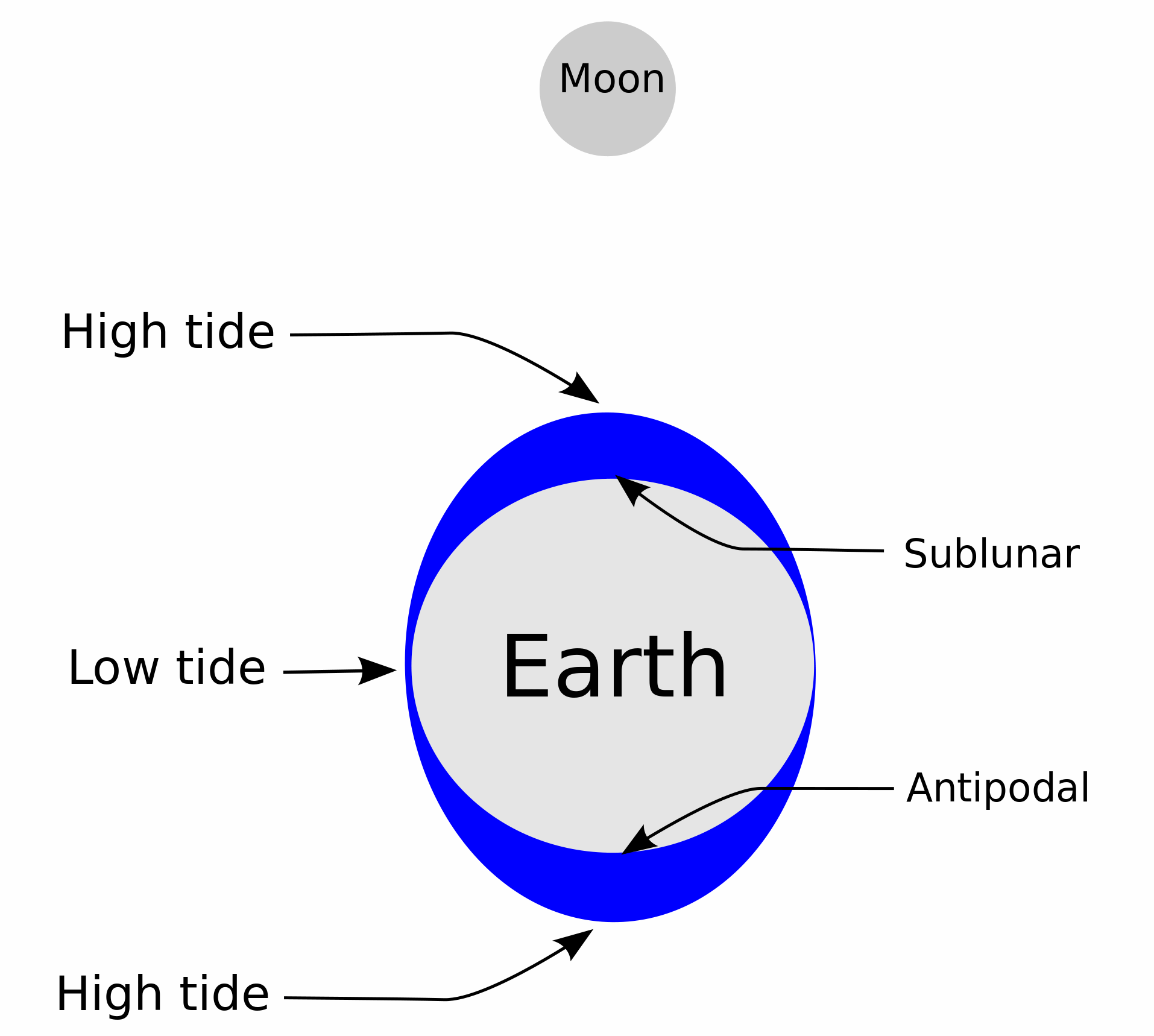
| | | | What we've been talking about is the vertical tide, which is the primary manifestation of tides. So let's go to the secondary step. Stick a garden hose in a bucket and turn on the water. The bucket fills, which we can compare to a vertical tide. When the water reaches the rim of the bucket, it overflows, in other words, moves horizontally. Ha! We have a horizontal tide. | | | | A horizontal tide, the one that goes in and out, consists of the overflow of a vertical tide. The water rises vertically in the ocean, and then has to spread out horizontally. You can't have a horizontal tide if there weren't a vertical tide first. In other words, in-and-out happens after up-and-down. [Note: there is also an additional phenomenon that operates quite differently, and is limited to where it exists. It's called a radial tide, which revolves like the radius of a circle. We'll get to that later.] | | | | If we can see the vertical tide against cliffs and piers, how do we see the horizontal tide? Let's start small, with reefs. At low tide in the ocean, there are exposed rocks. High tide comes, then spreads horizontally across these rocks, hiding them and creating an even worse navigation hazard. Or look at a small island. At low tide it has extensive beaches around it. At high tide, the water moves in horizontally on all the beaches, partially covering them, so that at high tide, the exposed part of the island is smaller than at low tide. | | | | But then think of any beach, anywhere. The difference between low tide and high tide is called the tidal range (Image by Jared), which would include the "black rocks" in Peggys Cove. If the beach has a steep slope, as in the illustration, the (horizontal) tide doesn't come in too far. The more gradual the slope, the further the tide can come in. In extreme cases, with a low, very flat beach, the tide can come in for many kilometers/miles, creating huge wet, muddy tidal flats that come and go as the hours pass. The most extreme example is the Bay of Fundy. | | | | The Bay of Fundy in the Maritimes is known for having the highest tidal range in the world. (!!!) Seeing the phenomena caused by that fact is one very good reason for visiting the Maritimes. We're going to end up talking about those phenomena in three segments. One we've already done. We talked in the last posting about the New Brunswick side of the Bay, including the Reversing Rapids ("Falls") in St John, and the mushroom-like Hopewell Rocks, exposed at low tide. The subject is coming up now in relation to the following discussion on the tidal bore at Truro. Finally, we'll be talking about visiting the Nova Scotia side of the Bay later on in the narrative, in a later posting. | | | | I think the situation we've seen so far is straightforward and uncomplicated. But when we ask the seemingly innocuous question why most places (not all) have TWO high and TWO low tides a day, given that we only have one Moon to create that bulge in the ocean that we call high tide, and also given that that Moon does NOT pass our way twice a day, then the explanation becomes really weird. Only the intrepid should now continue to venture into the World of the Anti-Bulge (cue the creepy music). | | | | While we can picture a bulge in the ocean under the Moon (the sublunar bulge), it seems counterintuitive that there should be a second bulge in the part of the ocean totally OPPOSITE the Moon! As we know, a point on the earth opposite a given point is called the antipodes (that I like to call the anti-foot), then this secondary bulge is called the antipodal bulge. I like to shorten that to anti-bulge. Take a look at this illustration (Image by Chiswick Chap). | | | | Of course the bulges are grossly exaggerated for the purpose of illustration, and the image assumes no land masses blocking the tides in oceans of constant depth. I'm going to try to explain it as I understand it, and in my own words. The Moon's gravity isn't all THAT strong. After all, it's much smaller than the Earth. It can pull nearby waters to it, but halfway around the Earth, those waters get drawn up, but not replenished by waters in the lower area. Also, the thickness of the Earth at that point is a factor. All this creates an area of low tides. The low tide areas also affect the waters in the antipodes to create the anti-bulge, where the effect of the Moon IS felt, but much more weakly. | | | | | | One other point needn't complicate things too much. The sun also has a tidal effect. While the sun is much larger and its affect much more powerful, it's further away, so the result turns out to be much less. Nevertheless, there is also a pair of much smaller solar bulges. When solar bulges coincide with lunar bulges, they supplement each other to result in extra high tides. |
| | | | This is another excellent illustration (Image by Krishnavedala) that should further help to clarify a difficult-to-understand situation. The satellite is the Moon (or the Sun), and the vectors (arrows) show water movement. The gravitational effect raises a nearby bulge (high tide) up to where the Earth presents its full girth, where the flow is forced both ways (low tide) to create an anti-bulge (high tide). | | | | Now, as the Earth revolves, any given point passes into high (sublunar) tide, low tide, high (antipodal) tide, then low tide again to complete a day. Given a 24-hour day, each change takes roughly six hours. | | | | Now after all that esoterica, it turns out that not every place on Earth has two daily tides, as this map (Image by KVDP/Michael Pidwirny) shows. While it's true that most places do have two-a-day (semidiurnal) tides, as shown in green, some have one-a-day (diurnal) tides, in yellow, and others still have a mix-and-match combination of tides, in red, called a mixed tide. These include two uneven tides a day, or one high and one low per day. Factors for these mixed tides are the size of the body of water involved, the size of the continental shelf, and the direction the coast faces. | | | | I have some additional material here about what we've discussed, and more, from a scientist at the University of Wisconsin. Copy and paste this link in another window to compare with the following comments:
http://www.uwgb.edu/dutchs/EarthSC202Notes/TIDES.HTM
| | | | TWO BULGES: I'm sure his explanation of the anti-bulge is more complete, and more accurate.
MOON & SUN: Good illustration of one supplementing the other.
NODES: The second of two maps shows how the continents stifle the free movement of tides, so that the tides circulate around nodes.
BAY OF FUNDY: The first map shows how many hours high tide arrives in the Bay of Fundy after high tide in Boston, across the Gulf of Maine. The second shows what we'll discuss more shortly, how the unusual funnel shape of the Bay squeezes water into both branches of its inner end to achieve amazing results, not only exceptionally high tides at this point, but tidal bores in the rivers leading into the Bay.
RADIAL TIDE: The most useful item here we've only touched on, and will discuss more now. Read what it says about the swirling water in the glass, and compare it to the quite unique radial tide that appears in the Gulf of St Lawrence, at the other side of the Maritimes from the Bay of Fundy. These two bodies of water make the Maritimes a textbook example of all kinds of tidal phenomena. Watch the radial tide circulating around a central point, Québec's Magdalen Islands, which are located in just the right point to feed this phenomenon. As the swirling water in a glass centers around a relatively stationary medial point, the tide enters the Gulf of St Lawrence through the Cabot Strait and then swirls around the islands. The tide affects, in order, Newfoundland, then Labrador, north-shore Québec, Québec's Gaspé Peninsula, New Brunswick, Prince Edward Island, and finally Nova Scotia's Cape Breton Island. At the northern tip of that island, the twelve-hour-old high tide swings in from the left as the new tide, the second of the day, enters at the right.
BOSTON TEA PARTY & TARAWA: You might find this additional historic tidal information of interest.
| | | | Bay of Fundy Tides As mentioned earlier, we'll split the Fundy information between this point, because the tidal bore comes up in the near narrative, and later on in the narrative, when we actually arrive at the Bay of Fundy. Let's start with copying and pasting this map of the Gulf of Maine (click):
http://www.gulfofmaine.org/images/gommi/map-gulfofmaine.jpg
| | | | You see the international border between the US and Canada. Also note an error. The border hits land at Campobello Island. St John is, to be accurate, up the coast to the right at the next indentation. On the map, we at first note the enclosure of the Gulf between Cape Cod and Nova Scotia. You can now picture more easily the above time difference between high tide at Boston and when it arrives at the Bay of Fundy, 3, 3.5, 4, and 4.5 hours later, the last two up the right fork, the Minas Basin. Also note the impediments of water entering the Gulf of Maine via channels around underwater reefs. All this has to be a factor in channeling water up into the Bay of Fundy, which, as you can see on this map, is relatively shallow as compared to the Gulf of Maine, and gets shallower still the further in you go. Now copy and paste this map:
http://www.yellowmaps.com/maps/img/_preview/CA/regional/tidalmap.jpg
| | | | It's clear here that the Bay of Fundy, while primarily located between NB and NS, also borders an area of the coast of Maine. These are the depths in meters/yards of the incoming tide. It rolls in on this flat tidal plain, which gets shallower and narrower the further you go. | | | | It's helpful to picture the nozzle effect. Watch the water dribble out of a garden hose. Then impede the flow with your thumb and watch how much faster the water sprays. Or a toothpaste tube. Pressure on the bottom doesn't do much. The same pressure near the nozzle makes toothpaste shoot out all over the place. The Bay of Fundy serves as a nozzle, squeezing water ever tighter, making it pile up, and flow faster, the further inland it goes. | | | | Beyond St John, on the St John River, with its Reversing Rapids ("Falls"), the Bay then splits around Cape Chignecto, forming two even smaller nozzles! When talking about NB, we mentioned Fundy NP and the Hopewell Rocks on Chignecto Bay, defined by its cape. The deep tide here then shoots up the Petitcodiac River at the city of Moncton as a tidal bore. But the south fork, defined by Cape Split (where "13m" is written) is the Minas Basin, leading to Cobequid Bay, and then to the (here not named) Salmon River to Truro, which we'll visit momentarily. The tide comes up here as an even more spectacular tidal bore. Note also two other rivers with tidal bores off the Minas Basin, the Shubenacadie, right next to the Salmon, and the Avon, right where the words "Minas Basin" are. | | | | Note these facts:
● The highest tides on Earth occur in the Minas Basin, as shown. The water level at high tide can be as much as 16 m (53.5 ft) higher than at low tide.
● Both upper basins of the Bay of Fundy have tides FIVE TIMES HIGHER than typical tides on the Atlantic coast of North America.
● Nova Scotia actually bends when the tide comes in. As 14 billion tons of seawater flows into the Minas Basin daily, the Nova Scotia countryside actually tilts under the immense load.
● Cape Split squeezes water coming into the Minas Basin through that narrow Minas Channel. The tides flowing through that channel are as powerful as 8,000 train engines or 25 million horses.
| | | | We've been tiptoeing around the term tidal bore. It's much better seen (we'll have videos) than merely described, because the description sounds too unbelievable. But we'll try. Picture an incoming tide squeezed by the Bay, by the Minas Channel, by the Minas Basin, by the mouth of the Salmon River. Nozzle after nozzle! The tide gets narrower and narrower and goes faster and faster. These rivers just listed are all located in just such a way so that twice a day, a huge RUSH OF WATER "bores" its way upstream as a wave, which flows upstream, actually on top of the water flowing downstream (!!!). This downstream water is the normal, natural freshwater flow of the river, plus the remnants of the tidal bore six hours earlier. You've gotta see it to believe it, and we are about to do so. | | | | One last preliminary point about the word "Fundy". There are two theories as to the origin of its name. The garbage theory is that it comes from the Portuguese fondo/fonda which means "deep" (think "profound"). Why Portuguese? And the Bay isn't as deep as the Gulf of Maine! The other theory makes more sense. Now remember, the Bay splits in two, and also there's Cape Split on the Minas side. The theory is that the former French name—and the French were most definitely in this area--for Cape Split (which is now Cap Split) was Cap Fendu, which means the same thing. Fendu? Fundy? Why not? Let's get back to the narrative. | | | | Truro Tidal Bore We left off the narrative in the last posting driving up from Peggys Cove to Truro. Copy and paste that same Nova Scotia green map we used before:
http://www.wtcchalifax.com/site-tcl/media/wtcchalifax/Nova%20Scotia%20Map.jpg
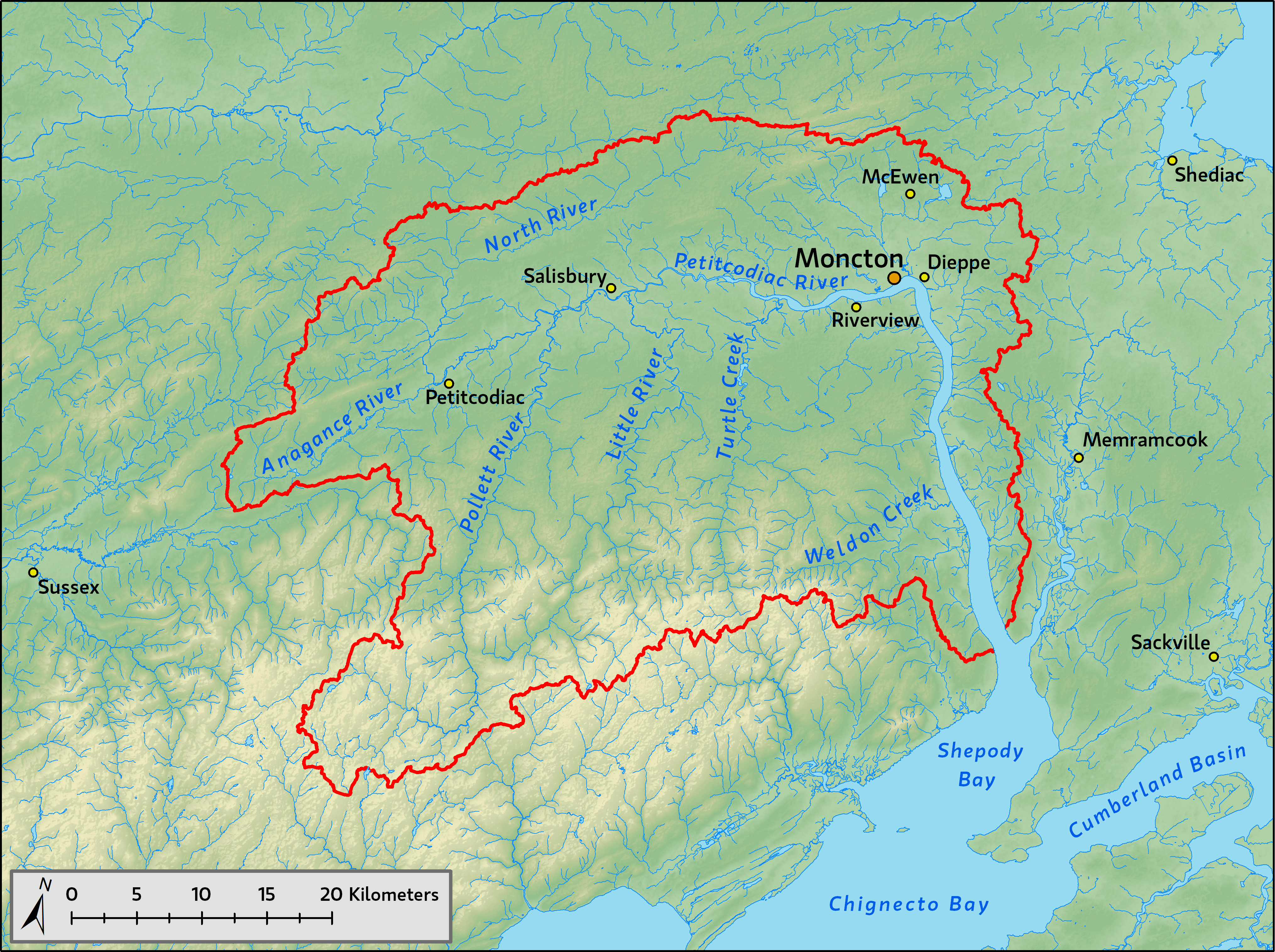
| | | | Reacquaint yourself with the two arms of the Bay of Fundy, and, at the end of the Minas Basin, find Truro, our first destination, where we'll stop on the way to Charlottetown, Prince Edward Island. Highways in color are superhighways. The superhighway in blue is the Trans-Canada Highway. While we're driving up 102, let me explain my past, unfortunate, tidal bore history. | | | | It was part of passing through NB in 1969, when we really didn't have the tidal schedules we needed, which today are online at your fingertips. We were lucky at the Reversing "Falls" and hit it right, seeing it flow in both directions. At Hopewell Rocks, we saw low tide, but weren't about to wait six hours to contrast the view at high tide. We then drove up the Petitcodiac River to Moncton and its Bore View Park, where tidal information was posted, including the two daily bores. Here our luck ran out, and had to wait 3.5 hours for the tidal bore to come. Which we grudgingly did. And it was a fizzle (but now I know why!). Yes, we did see water flowing upstream on the surface of the natural flow going downstream, but it was hardly more than a mild ripple, not a huge wave. So for a long time, I've been "down" on tidal bores. They're nothing, right? Wrong! | | | | Here's the explanation of what happened at Moncton (MUNK.ton) as I've now found it out. This is the watershed of the Petitcodiac River (Map by Cornforth). Minas Basin is off the map to the lower right, so we see just the Chignecto Bay with the river flowing into it. Note Moncton at the top of that uppermost bend, but note Riverview slightly upstream as well. | | | | One has a feeling that Canadians know what they're doing, and tend to do things right. But on this trip, I've come across at least three environmental idiocies, all involving the free flow of water versus rock-and-earth causeways, to which I'll add this story that I've just found out about. We saw our ripple in 1969, and I now see that it was just in 1968 that a controversial rock-and-earth causeway was built between Riverview and the upstream area of Moncton. Its purpose was to prevent agricultural flooding (there has to be better ways) and to connect the two communities (bridges, anyone?). Before this causeway, the river had one of the world's largest tidal bores of 1-2 m (3.3-6.6 ft) and that moved at 5-13 km/h (3-8 mph). After the causeway was built, the bores reached about 5 to 75 cm (2 to 29.5 in). I'm sure we were unlucky enough to have gotten our ripple in the low range of that. | | | | Right from the beginning the causeway caused tremendous silting problems in the river just downstream from it. It restricted the movement of fish and reduced salmon catches by 82%. In 2003, the Petitcodiac River was declared the most endangered river in Canada because of all this. But finally, wiser heads prevailed, and in 2010, the causeway's gates were opened permanently as part of a $68 million project to restore the river, to be completed by 2015. The river then began flushing itself of the silt, and the tidal bore is restoring itself to what it once was. This is an aerial view of Moncton and the Petitcodiac River (Photo by sebpaquet), but I don't know if it was before or after the opening of the gates. Bore View Park is at the high point of the loop in the river, and the causeway is closer to us. | | | | To shift our attention back to the Minas Basin and Truro, copy and paste this map:
http://www.bofep.org/Publications/Fundy%20issues/minas_map.GIF
| | | | You know many of these places, and we'll be coming back to them later in the trip. But for now, just reference again Cobequid Bay, and the Salmon River going right into and beyond Truro. | | | | Now as we're approaching Truro, we have to explain something. We're visiting the NS side of the Bay of Fundy at the end of the trip, so what are we doing here now? It's actually a clever, last-minute save. As opposed to the 1969 trip, today we have online schedules for the tides and bores. Check out this website: http://bayoffundytourism.com/tides/times/ | | | | Click on any tide schedule—they're updated weekly--but particularly check out the tidal bores at Truro and Moncton. The problem is, although there are two bores a day about twelve hours apart, the times can be either more or less convenient. I'd originally wanted to see the bore when coming back through this area in a couple of weeks to see the Bay of Fundy, but the times for the day I'd be here were something awful like dawn and sunset. Not only would that be more awkward to see, but it would require an overnight stay in Truro. As luck would have it, the day I'd be passing Truro between Peggys Cove and Charlottetown, I discovered that the bore would be coming through at midday (actually, 12:53 PM) and midnight. Couldn't be better, so that's why we're stopping to see the bore on the way to Charlottetown, and separately from visiting the Bay itself, later. | | | | We're at Exit 14 for Truro, so copy and paste this excellent map:
www.trurons.com/truromap/
| | | | It's interactive, so if you touch it, you'll start drawing lines--just hit "reset" at the upper left. Now, although I'd say I'd never actually been IN Truro itself, that means finding my own way around. But actually, the Ocean came through town just two days ago. Start at the top center, find Main Street, and the rail line is right next to it. It crosses the Salmon River, which runs right through town, and I remember seeing high riverbanks from the train window. The line bends, the station is on the street called Esplanade, and then continues on to Halifax, from where you see highway 102 returning. From the center, though, Prince Street leads right to meet us as we come off the highway at exit 14, where we turn left under the highway. At a cluster of turns, south of which is the Tidal Bore Inn, we turn right for no more than 15 seconds and we're at the Salmon River at South Tidal Bore Road. It couldn't be closer or easier. We park on the left with a perfect view of the river, at an ideal ten o'clock angle down the green lawns to the river. | | | | Actually, the place is a bit disheveled. There's a closed pavilion that maybe does business in the summer. Behind us is an old, boarded-up mom 'n' pop type motel, which has a perfect view, but apparently wasn't successful. There are abutments for a bridge over the river that used to connect to what is now called North Tidal Bore Road on the other side. It's still early, but there are one or two cars waiting already. The whole time, there won't be more than about ten or so. But we're at an ideal point, which is apparently considered the mouth of the river (it's hard to tell, as it keeps on widening gradually on the map) and the head of navigation. | | | | My own experience on 28 May 2014 was this. I arrived a good 1.5 hours before the announced time of 12:53. I looked around a lot, and then devoured that leftover muffin from breakfast. The river was low, and high muddy banks were exposed on both sides, as was a huge mudflat on the other side, way off in the left distance. It was very obvious that the water at that time was flowing downstream, to the left. It would have been fresh water from the river, plus the remnants of the salt water from the previous bore at around last midnight. I remember seeing some rocks exposed in the river. Actually, at this point I was totally bored (pun intended), so I sat in the passenger seat to have room to work, opened my laptop, and continued writing about China. | | | | Deeply engrossed in my work, even with the car door closed, I heard it before I saw it. It had come ten minutes early! So much for total accuracy in forecasting. I closed the laptop and jumped out of the car, locking the laptop inside, and stepped up to enjoy the spectacle. I hadn't missed anything, as the sound had preceded the visual, and the tidal bore rushed upstream (Photo by Jakemete), piggybacking on the water flowing downstream (don't worry about this teaser, videos will follow). As it came, any exposed rocks in the riverbed were hidden, water rose up the banks, and that large tidal flat disappeared as well. | | | | It was all over within a couple of minutes as the bore disappeared under the highway overpass. And then it stopped. Stopped! Once fully arrived, having reached its full extent, it reversed itself immediately, and started flowing downstream, but much more slowly. It was eminently clear why the expression "the tide turns" means what it does. I hung around for another half hour, watching the river start to return to the way I first saw it when I arrived. | | | | As promised, I have two YouTube videos of the Truro Tidal Bore. I couldn't decide which one I preferred, but I'm sure you'll want to watch both: | | | | | | | | On both videos, watch that large tidal flat in the left distance disappear under water. It will reemerge after the tide turns. Also note how the roar of this wave is constant. Compare that roar to the sound of waves at a beach you've visited, where the roar is only intermittent, until the waves break. This wave doesn't break until it's done playing out. Especially on the second video towards the end, you can see the remaining large bare mud slopes on the sides of the river under the lawns. You see this all over, and they have to indicate that at times the water does get this high. | | | | The Missing Acadians While I was killing time waiting for the tidal bore, I went over to read a historical marker near that closed pavilion. Normally, I'd be glad to hear about people being proud of settling a community, but this one bothered me. I copied it down verbatim: | | | | | | FIRST LANDING - In 1760-62, near this head of Cobequid Bay, the first English-speaking settlers of the townships of Onslow and Truro landed. Of Ulster Irish, Scottish, and English stock, these pioneers were among those brought to Nova Scotia from New England by the government to take up the lands formerly occupied by the Acadians. |
| | | | The tone of the prideful statement didn't sit well with me. At least they mentioned that the land was not their ancestors', but neglected to mention it had been stolen from the former owners. It was only later that I found Cobequid on the maps of disappeared Acadian villages after the deportation (copy and paste):
http://greenerpasture.com/Content/ancestorimages/acadia.jpg
| | | | I've since checked. The original Mi'kmaq name for the Truro area was a word meaning "end of the water's flow", which was altered by Acadian settlers to Cobequid when they arrived in the area in the early 1700s. By 1727, they established a village by that name near what is now downtown Truro. In 1755 began the expulsion of the Acadians. The town was resettled in 1761 by Ulster Scotch-Irish Presbyterians, who arrived via New England (one source says New Hampshire) and renamed the city Truro after Truro in Cornwall. But then, people taking over other people's homes and property happens anytime ethnic cleansing takes place; Europe in the 20C is a good example of that. | | | | But the juxtaposition in Truro of history and natural science gets to me, the historic tragedy of the deportation taking place at the location of a natural phenomenon. I can visualize soldiers forcing people onto ships, but only during the slack tide between tidal bores. I find that image particularly disturbing. | | | | Prince Edward Island We're now on our way to the former Île Saint-Jean (Saint John's Island), now called Prince Edward Island. But the question is why is this our destination. My opinion: of the three Maritime Provinces, Nova Scotia (NS), which includes the fourth area, Cape Breton Island, is the prime destination. New Brunswick (NB) is nice enough, but best utilized as I've done it, to visit as a pass-through area. PEI (I'll also be using the official two-letter postal code, PE) is charming, certainly a destination, with a pleasant countryside and a petite Victorian capital. It's worthy of vacationers, people who want to spend some time there, but it has little to see of deep substance for travelers, if you know what I mean. And after several visits, I've paid my dues there as well, having enjoyed those visits. Besides, if we're headed north on NS, then south, why cut over to PE one more time? | | | | Confederation Bridge It's the bridge, plain and simple. Look at the green NS map again. Both times we drove, it worked out that we took the ferry out of Pictou NS and left on the former ferry out of Borden PE over to Cape Tormentine NB. Then, the Deutschland docked in Charlottetown harbor and we strolled around the pleasant, low-rise town. But son of a gun, when I wasn't looking, they went and replaced that latter ferry with a looooong bridge over Northumberland Strait. Originally just referred to as the Fixed Link, since that was just what it was, because of the Charlottetown Conference that led to Canadian confederation, it was finally named the Confederation Bridge. The bridge was what tipped the scales for me to go enjoy PE and Charlottetown once again, even though the drive was out of the way. So on the green map, let's follow the superhighways past Amherst on the NS/NB border, cross the border and immediately turn right on the NB road up to the bridge, both of which can be discerned on the map.
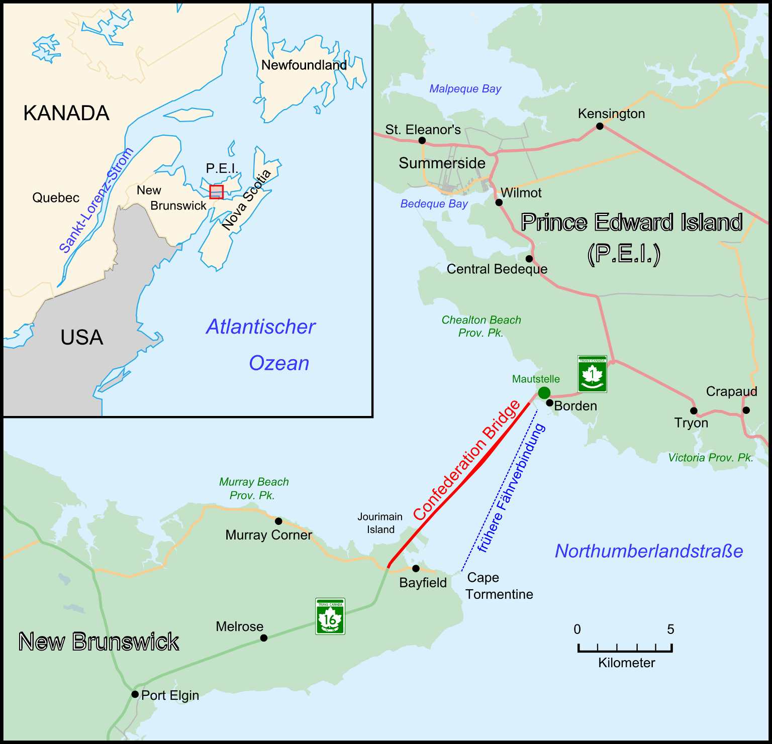
| | | | Put the green NS map aside for now and copy and paste the link to the map of PEI:
http://www.photoscanada.com/gallery/albums/prince_edward_island/map_of_prince_edward_island_canada.jpg
| | | | It's a small, banana-shaped island, and the smallest province. Disregard all the dashed lines on both sides of the Northumberland Strait, because they show railroads that do not exist anymore, with the exception of the Ocean through Moncton and Amherst. But you can see the road connection from Amherst into NB and to the bridge. You see Charlottetown on its unusual, X-shaped harbor. The majority of islanders live in or near here. The center of the island has the most interesting spots to visit, including PEI National Park on the beachy north shore facing the Gulf of St Lawrence. And that's pretty much it for PEI. | | | | As we approach the Confederation Bridge (Map by Wladyslaw), this German map shows us that it leaves NB from the Bayfield area, while the former ferry left from Cape Tormentine, but the destination is still Borden on the PE side. Since we're here to see the bridge, let's take the last exit before the bridge and drive to the right down a country road so we can get a side view (Photo by Wladyslaw). | | | | The bridge is 12.9 km (8 mi) long and 11 m (36 ft) wide, with just two lanes (Photo by Share Bear). The speed limit is low, but the openness of the bridge gives just a little bit of an eerie feeling, including navigating both the curve and rise (Photo by Dr Wilson) along the way. I don't know why the curve was added—currents perhaps--but the rise is the navigation span for ship traffic on the PE side. Then coming down from the span (Photo by WikiPedant) is a little eerier still, a bit roller-coaster-like. The crossing takes about ten minutes, and afterwards, we pull over on the Borden side (Photo by WikiPedant) to look back and see the bridge from there. It's the same south face of the bridge, but now from PE. Here again both the curve and rise are obvious. | | | | The toll is one-way, and so is the ferry fare to Pictou. You get onto the island free either way, but then pay to leave. You can mix-and-match as to ferry and bridge. The bridge costs C$45, and the ferry C$69 (both figures are slightly less in US$). It would have been logical, if you look at either the NS or PE map, to have left by the ferry, also for old times' sake. But it was still shoulder season. The ferry in the summer leaves very frequently, but in May only like five times a day, and I didn't want to play around with that. Anyway, the bridge is cheaper, so I left as I came. You pay leaving by credit card into a machine. | | | | The bridge opened in 1997. The number of visitors visiting the island increased from 740K the previous year to 1.2 million the opening year when the bridge was a novelty, but then has dropped back to an average of 900K annually, still an increase. The only problem with that is that the number of people spending the night on the island has decreased, because many that might have spent the night just visit the island on day trips out of Moncton or even Halifax. Tourism officials have responded by building more attractions for day trippers, such as golf courses. But the bridge has helped agricultural exports, and has also brought more commerce to the island. | | | | Charlottetown Petite. Cozy. Low-rise. Victorian. Atmospheric. That's Charlottetown. On our PE map, let's follow the route from Borden into town. Note also that that the distance from town to the north shore is even less than what we're doing now, so narrow is the island. Also note a geographic point, which will get into much more deeply shortly. Charlottetown lies on an unusually-shaped harbor, one that looks like an X, with the outlet on the lower right leg of that X. Therefore, the town snuggles in a peninsula between the two upper arms of the X, so we have to maneuver around that North River to enter town from the north. Copy and paste this link to a map of Charlottetown (click):
http://princeedwardtours.com/wp-content/uploads/2012/04/charlottetown-map1.jpg
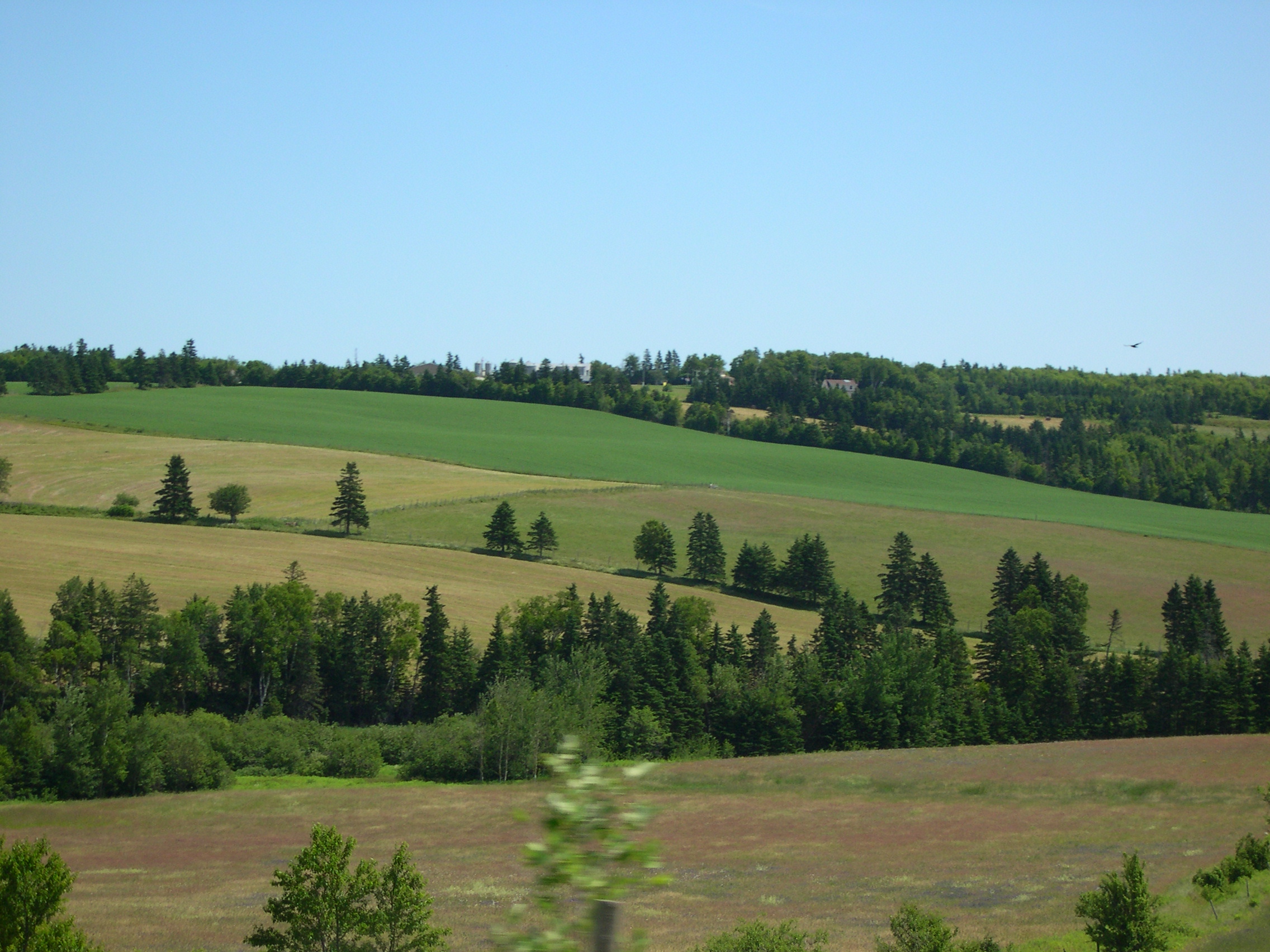
| | | | North River Road will bring us down close to Victoria Park. We'll zigzag on Euston and Rochford, noting already the Victorian quality of this neighborhood so very close to downtown. We pass Rochford Square, actually a park, one of four laid out symmetrically around the center. Check them out. Then we turn right (outward) on Grafton to the Heritage Harbour House on the right, a Victorian-style mansion now a B&B. Note how close we are to both Victoria Park and downtown. Location, location, location. Plus a charming B&B. We'll take a late-afternoon drive around the Victoria Park area for the water views, and leave the rest for tomorrow. | | | | Naming here was a family affair. Think of George III. His wife was Charlotte of Mecklenburg-Strelitz, and the city got named for her. His fourth son, who was to be the father of Queen Victoria, was Prince Edward, hence the island's name. And the main historic street is Great George Street. I can't find any specifics, but that does seem to be named for George himself. And the town, founded in 1768, is petite. In 2011, the population was only 34,600, and the urban area 42,600. | | | | The next day is our one full day on the island, and we'll start with the historic best. It's no distance at all from the b&b down Grafton Street to Province House (see map), but we'll take the car, since we'll be going further. We'll go around to the front of Province House and can park right on Great George Street. | | | | Great George Street is the epitome of Charlottetown historic urban architecture and political history. The cluster of important buildings around it are part of the Great George Street Historic District. The street is wide, and just six blocks long, leading from the waterfront up to Province House, and couldn't be more centrally located. | | | | The wharf is where the Deutschland docked on our earlier visit. It's also where on this trip I saw the Maasdam of the Holland America Line pulling out. In 1864, it's where the representatives of the Charlottetown Conference arrived, and walked up the slight ascent of the six blocks of Great George Street to Province House for their historic meeting. Probably half the structures they saw along Great George Street are still there. While the buildings are of various domestic architectural styles and functions (residential, commercial, governmental), they are all of similar scale and setback, and the view is harmonious. | | | | As an example of the look of Great George Street, there are the Great George Inns, restored houses forming one Inn. Most iconic of them is Pavilion House (Photo by JustLiza) (click). It was built in 1846, and, at the height of its popularity, it hosted some of the delegates from the Charlottetown Conference. In 1990, the current owners began restoring it, as well as adjacent buildings, turning most of an entire city block into one hotel, which opened in 1996 as the Great George. | | | | Across from the Inn is the distinctive St Dunstan's Basilica (Photo by JustLiza). My clearest memory of seeing this involves the large historic marker describing it, that had a column each in English, French, and Mi'kmaq, which was the first time I saw that much written in Mi'kmaq all at once. | | | | At the top of Great George (see map) one block of Richmond Street is set aside as Victoria Row, because of the magnificent row of commercial stone buildings on its south side in an impressive Victorian style. Turning around under the front arch at the entrance to Province House, we look back to see the viewscape down Great George Street (Photo by Jim Logan). From the left, we see typical period buildings, between the trees we look six blocks down to the water, then St Dunstan's. The people you see are just leaving Victoria Row, not visible to the right. This is the heart of Charlottetown. | | | | But let's check where we're standing: in the archway at the entrance in the south façade (it has a simillar north façade) of Province House (Photo by Laurenp3412). Opened in 1847, its architectural style includes Greek and Roman influences, which were common in public buildings all across North America at this time. Note the windows one flight up. When we enter, we find it's too early in the season for tours, but that's no problem. We go up the fancy staircase to find three rooms upstairs. Those windows behind the columns in the façade are of a large library, used at the Conference and still used today. Windows not visible to the left were to the Confederation Chamber, the historic room where the delegates met in 1864. I have no pictures. The windows to the right on the façade in that picture are of the PEI Legislative Assembly Chamber (Photo by Charles Hoffman), the only chamber in the unicameral PEI system. This room is the same size and similar in style to the Confederation Chamber. While much of the rest of the building has been turned over to Parks Canada for historic purposes, the Legislature does actually meet in this room. If it looks small, welcome to PEI! There are only 27 delegates to the entire legislature! The ornate chair in the center belongs to the Speaker. Normally, delegates of the currently governing party sit to the Speaker's left (off the picture, but a mirror image) and the opposition sits to his right, in those few places you see. But as it turns out, the party presently governing has an overwhelming majority of 24-3, so those three front benches are the opposition and behind them as well as opposite them are the majority delegates. | | | | To see if we can tie all this together, look at this aerial view of Charlottetown (Photo by Martin Cathrae). Once again, just to make us crazy, north is to the left. Click and look at the center bottom, where the trees give way and you can see a large, open street. This is Grafton Street (see map). The block away from downtown has the b&b, one of those buildings on the left side. Two blocks into downtown you might be able to see the opposite side of Province House, set back from Grafton. You have to estimate where Great George is, running past St Dunstan's to the harbor. Now off to the North Shore. | | | | Prince Edward Island National Park On the PE map, you can see it's just a short drive to the beachy side of the island, where the PEI National Park has been established along the shore. The road that runs for 50 km (25 mi) along the dunes and beaches is called Gulf Shore Parkway. During the season, when people are using the road and the park to go to the beach, there's a toll, but one advantage of being in the preseason is that there's no toll—and no crowds of people. | | | | But there's one thing that will surprise, if you don't expect it. We noticed it the first time years ago when we got off the ferry from Pictou. PEI is red! That is, its earth and sand almost everywhere is one shade of red or another. Let's look first at the pastoral landscape we've been passing through so far, an area of farmland and rolling hills (Photo by Dylan Kereluk). But look close, and note even here the red earth trying to peek through. But once on the Gulf Shore Parkway there are plenty of stopoffs to look at the severe red cliffs (Photo by chensiyuan), some rockier than others (Photo by Ryan Tir). At some points you can walk down below and walk along the red sand beach (Photo by Qyd).
| | | | That (Fictional) Girl On that first trip to PEI in 1980, shortly after our being surprised by the red earth, we saw directions to Green Gables, in Cavendish on the north shore. It meant absolutely nothing to me at the time, but Beverly froze. GREEN GABLES! WE'VE GOT TO GO TO GREEN GABLES! It was at this point that I first became acquainted with Anne of Green Gables. Beverly, as a young teenage girl, had become intensely involved with the series of books, and its fictional heroine, but had forgotten that Green Gables was located on Prince Edward Island until we saw those directions to it.
| | | | It has to be a gender thing. I suspect that many females reading this will have the knee-jerk reaction that Beverly had, harking back to their teenage years, and that most males will wonder what the fuss is all about. (And some will know it from TV and films.) And it isn't really a matter of being acquainted with Canadian literature or not; just as you don't have to be acquainted with Swiss-German literature to know who Heidi was, just as you don't have to be acquainted with Swedish literature to know who Pippi Longstocking/Pippi Långstrump was, you don't have to know Canadian literature to be enamored with Anne of Green Gables, and with the author of the books, Lucy Maud Montgomery. I got a condensed and very rapid education at the time as we without a doubt added Green Gables to our itinerary on the spot. We toured the house the stories were based on, and those enlightened ones who had read the books recognized this corner with an ooh! and that room with an aah! as though they were part of their DNA. | | | | Here are the results of my Green Gables education at the time, further enhanced by current research. Green Gables is the name of a 19C farm in Cavendish, on the north shore of PEI. Simple enough. The house is white with green trim and with a green roof, including the several gables, hence the name. The property is adjacent to, and on the inland side of, the PEI National Park, and today constitutes a component of the park, so the plot thickens. Why have a farmhouse in a National Park? | | | | Lucy Maud Montgomery was born in nearby New London in the late Victorian era. When her mother died, she was brought to Cavendish to be raised by her mother's parents. She would also frequently visit her cousins, the MacNeill family, who owned a nearby farm built sometime between 1830 and 1870 named Green Gables. (Aha!) She also became the local postmaster, and her life in the community formed a strong impression on her. She would later include much of her experience in this rural community at the turn of the 20C in her subsequent writings, most notably in her 1908 literary blockbuster Anne of Green Gables. | | | | Montgomery wrote the book, which has become a literary classic, as fiction for readers of all ages, but since the middle of the 20C it's become considered a children's novel, which is just about the time Beverly would have read it. It tells of an 11-year-old orphan, Anne Shirley, and of Matthew and Marilla Cuthbert, a middle-aged brother and sister who have a farm (coincidentally called Green Gables) who want to adopt a boy to help them. But Anne is sent instead in error, and the novel apparently tells how Anne works her way into the affections of the Cuthberts, the local school, and the town. Montgomery used the house and surrounding area as the romantic basis for Anne's adventures, including places such as the Haunted Wood and Lovers' Lane. | | | | Anne of Green Gables, whose first edition was apparently published in the US, in Boston, was an immediate success and has sold more than 50 million copies and has been translated into 20 languages. It's one of the most notable literary landmarks in Canada. (Who knew?) Montgomery became famous in her lifetime and had an international following. In 1909 there followed Anne of Avonlea in 1915 Anne of the Island, and more came after that later on. Montgomery published 20 novels, most set on PEI, and numerous short stories, poems, and essays. | | | | The house was designated a National Historic Site of Canada in 1985. Montgomery never actually lived in the house, but upon her death, her wake was conducted in the living room of Green Gables for several days prior to her funeral at the local church and burial in the local cemetery. | | | | It will be of no surprise whatsoever that Beverly and I did make our way to Green Gables (Photo by Peter Broster) that first time years ago and that we toured it end to end. I saw its nooks and crannies, including the so-called Anne's Room (but she's fictional!) (Photo by Ewok Slayer) as an enjoyable experience touring a 19C farmhouse, while Beverly and the others who'd followed Anne's adventures in years past kept on "recognizing" this nook and that cranny by name. | | | | On this trip I did homage to Anne and to Beverly's enjoyment of our earlier visit by stopping off at the Green Gables site, and viewing it from outside, but not touring it again. There also now is a small free museum adjacent about Montgomery, Anne, and Green Gables, which I did visit. | | | | Since I found out how international Anne has become, I looked up how the name of the novel has been translated, especially since the architectural concept of a gable may or may not translate.
The name in English, Anne of Green Gables, is a little unusual, since the preposition "of" uses the house to identify "which Anne" is being referred to, in other words, "Green Gables Anne" as opposed to any other.
German uses Anne auf Green Gables, ducking the bullet of translating the name of the house, but using the preposition for "at" with the result of it saying "Anne at Green Gables". It works fine, but the implication slightly different from the original.
Dutch uses Anne van het Groene Huis, or "Anne of the Green House". It has the same preposition as English, but ducks the issue of what a gable is.
Italian uses Anna dei Tetti Verdi, or "Anna of the Green Roofs". Her name altered; same preposition; dodging the issue of a gable.
Spanish has Ana de las Tejas Verdes, which is the same as the Italian: altered name, same preposition, roofs not gables.
Swedish has Anne på Grönkulla, which uses the preposition for "at" like German does.
French has Anne . . . la maison aux pignons verts, or "Anne . . . the House of Green Gables". While French does actually have a word for "gable", the weird ellipsis avoids any preposition whatsoever, so no relationship is shown at all!
| | | | Two final thoughts on this subject: my small, sloped-roof single room in the Victorian b&b at Louisbourg a few days later was called Anne's Hideaway. It would have been dastardly of me, and possibly anti-Canadian, not to have recognized the reference. | | | | The President of Ireland, Mary McAleese, a female as you will note, during a state visit to Canada in 1998, referred to the Confederation Bridge leading to Prince Edward Island as the "Span of Green Gables". I rest my case. | | | | Port-la-Joye / Fort Amherst A look at our map of PEI will show how we've moved from the Charlottetown end of the National Park to the west end, which shows the protruding little green park area indicating Green Gables. We'll begin our return to town on that gray road across the rolling central hills. But first I want to go somewhere I haven't been before. Michelin makes reference to a certain Fort Amherst in an out-of-the-way area on the end of a peninsula, but it looks enticing. Maybe it's worth a bit of an extra drive. (And it is.) | | | | On the map, continue to note the odd X-shape of Charlottetown Harbour. From the southwest of the X, we see, in order, the West River, the North River, and the Hillsborough River (from the East) converging and emptying to the southeast, which is the entrance to the harbor. Geologically, this must have been interesting historically. There actually are rivers on the inner ends of each branch, but most of the lower reaches of each are in fact estuaries, forming the X-shaped harbor. Historically, some degree of subsiding of the land must have taken place so that the sea flooded the mouths of the three rivers forming four peninsulas. In any case, Charlottetown is located on the northern peninsula, between the North and Hillsborough Rivers, but before heading back, we're going to head down that winding gray road to the southern peninsula for some mild adventure. (No, that's not an oxymoron. Skydiving is wild adventure. Discovering interesting geography—and history—is mild adventure.) | | | | Doing what we do to write up travel experiences, so that "we're all taking the trip", depends heavily on maps and pictures. I've now found the ugliest map I've ever used on this website that, as it turns out, shows just exactly what we need to continue. Forgive me for subjecting you to this map, whose link you should copy and paste in another window, then click to enlarge:
http://www.peifa.org/userfiles/Charlottetown%20Closed%20Status_April%2029%202011.jpg
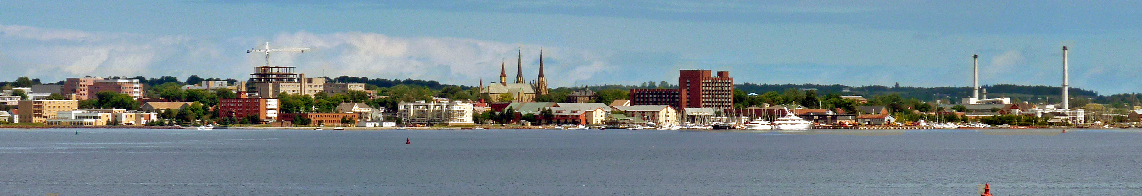
| | | | Now let's study closely this beautiful horror (now THAT's an oxymoron!). The original purpose of the map is apparently to show which areas of the harbor are safe for shellfish harvesting, but let's ignore that for the beauty of the detail shown. The green area on the lower right is the open sea of the Strait of Northumberland, which we crossed to get to the island. The other green area, the three red areas, and the black area, are all Charlottetown Harbo(u)r. | | | | You can see how small the built-up area of Charlottetown is. You can also see exactly how we arrived yesterday from the Borden end of the bridge, entering from the west. We didn't stay on the dark red road, but turned IMMEDIATELY south as soon as we'd cleared the North River, zigzagging a bit to arrive at the Victoria Park area at the bottom, near downtown, for the b&b. | | | | But today, returning from Green Gables, we're working our way along that southern peninsula to its far eastern end. The first surprise is pleasant. Just at the point where there's a sharp right turn in the road is a cluster of houses. It looks like a regular, suburban community, except that there's a sign proudly pointing out that most of the people who live in that community are Mi'kmaq. We make our right turn and continue to a left turn that takes us out to the entrance to the port. | | | | It's still early in the season for the visitor center to have opened, but everything is clearly explained outside on signs. It's more than just the British Fort Amherst. The complete name now gives full historic credit to the facts of the situation; it's called the Port-la-Joye--Fort Amherst National Historic Site, and the visit is an enjoyable end to our day and to our PEI stay. | | | | Port-la-Joye appeared earlier on the map we saw of Acadian settlements whose inhabitants were later deported. But the first European settlers on PEI were French military personnel brought over from Fortress Louisbourg on Île Royale (Cape Breton Island), who founded a settlement on this peninsula at the entrance of the natural harbor in 1720. The French military also transported Acadian settlers here from Louisbourg, and Port-la-Joye then became the capital of Île Saint Jean (PEI). When it was taken over by Britain, the French fort was changed to the British Fort Amherst. At first, it continued to be the British capital, but in 1768 this area beside the port entrance was abandoned entirely and the capital moved across the harbor to what became Charlottetown, which is opposite the entrance instead of being adjacent to it. | | | | Visiting the site today, we see just earthworks remaining from Fort Amherst, but also other indications of where Port-la-Joye had been next to it, as well as monuments commemorating the Acadian deportation. This is Warren Cove (Photo by MTLskyline) in the harbor as viewed from the grassy earthworks of Fort Amherst. But then walking over a little further, one can stand on the cliffs right at the entrance to the harbor, which would have been where the Deutschland entered that time we were on it. In addition, one could see all three of the rivers from a series of grassy lawns, and also one had an excellent panoramic view of Charlottetown across the harbor (Photo by MTLskyline). It's a beautiful end to a nice visit. | | | |
| |
|
|
|

