|
Reflections 2011
Series 26
October 25
North Coast II: Climate - Arctic & Tundra - Subarctic & Taiga
| | I suspect that most people who think about it at all (which immediately reduces our database dramatically) just feel that there’s some sort of a cold area up there in the north called the Arctic--and way down in the south called the Antarctic--and leave it at that. But it’s more refined than that. There’s also a Subarctic. What’s that? Might there also be a “Subantarctic”? If not, why not? Many have heard the word “tundra”. Just what is it? Fewer know the word “taiga”? What’s that? A trip to the north coast of North America is a good occasion to clarify all this, and to add it to what was said about the pair of cold-weather 2006 trips to Spitsbergen (2006/6) and to Antarctica (2006/15). | | | | I had first researched all these terms, and then at the last minute came across something even broader and more helpful, the Köppen-Geiger climate classification system. We’ll present this first, just out of general interest. The advantage of this broader knowledge base is so that, in addition to the cold-weather climates that are our present topic, we can also refer to the temperate and warm-weather climates we’ve discussed over time. | | | | Climate via Köppen-Geiger Although it’s been modified considerably up to the present day and still has its faults (as I understand), Wladimir Köppen first established this system in 1884, and it’s still the most widely-used system of climate classification. Köppen was a Crimean German (Krimdeutscher), a descendant of ethnic Germans who, along with Russians and Ukrainians, were sent by Russia to the Crimea starting in 1783 to dilute the local Tatar population. Köppen himself modified the system in 1918 and 1936, and then collaborated again with German climatologist Rudolf Geiger on further changes, so Geiger’s name is often attached to Köppen’s. (No, it’s not THAT Geiger. It was Hans Geiger who in 1908 was on of the developers of the Geiger counter.) | | | | The Köppen system is based on the concept that local vegetation is the best expression of climate. In other words, the flora that grows in a location indicates what the location’s climate is (evergreens versus cactus). Therefore, the boundaries of climate zones have been drawn based on native vegetation, but also combine information on temperature (hot, moderate, cold), precipitation (high, low), and the seasonality of precipitation (dry season, wet season). The Köppen scheme divides climates into five main groups indicated by the letters A to E, broken down into types and subtypes, indicated by additional letters. We’ll concentrate at the end on the two “chillier” ones, D and E. This is the Köppen-Geiger map of the world’s climates (Map by Peel, M. C., Finlayson, B. L., and McMahon, T. A., University of Melbourne). | | | | Group A: Tropical Climates Tropical climates are characterized by constant, year-round high temperatures (at low elevations). For a climate to be called tropical, the cutoff is a temperature average ABOVE 18°C (64°F). Included climates are: | | | | | | Tropical Rainforest Climate (Af, f for forest), which shows a year-round average precipitation of above 60 mm (2.4 in), is usually found near the equator, and has no natural seasons
Tropical Monsoon Climate (Am), which results from the monsoon winds that change direction according to the seasons, and does have a driest month
Tropical Wet-and-Dry (Savannah) Climate (Aw, w for wet), which has a pronounced dry season and is usually on the outer margins of the above.
|
| | | | Group B: Dry (Arid & Semiarid) Climates Here, precipitation is less than potential evaporation. The driest areas are the Desert Climate (BW); less dry ones are the, Steppe Climate (BS). Further breakdowns are based on temperature. In each case h indicates that the coldest month is nevertheless ABOVE FREEZING, and k indicates that at least one month falls BELOW FREEZING. [I just got an epiphany for the unexpected letters. Köppen was German. W is for German Wüste (desert, wasteland); h & k are for heiss & kalt (hot & cold). Let there be light.] | | | | Group C: Temperate Climates As the name indicates, these climates exist in a midrange between warmer and colder ones. They have a warmest month average temperature ABOVE 10°C (50°F) (the Group E Polar Climate cutoff) and a coldest month average temperature between the above Group A tropical cutoff of 18°C (64°F) and the below Group D Continental cutoff of -3° C (27°F). The second letter in the code indicates precipitation: w indicates dry winters, s indicates dry summers, f indicates significant precipitation year-round. The letters a, b, c indicate degree of summer heat from highest to lowest. I’ll just indicate climate names and select locations. For these, the last letter of the codes moves in order from a to d, warmest to coolest: | | | | | | Dry-Summer Subtropical or Mediterranean: Adelaide, Athens, Barcelona, Cape Town, Lisbon, Los Angeles, Perth, San Francisco, Santiago de Chile
Humid Subtropical: Atlanta, Belgrade, Brisbane, Buenos Aires, Hong Kong, Houston, Milan, Odessa
Maritime Temperate or Oceanic: Bergen, Hamburg, Hobart, London, Melbourne, Vancouver, Wellington
Maritime Subarctic or Subpolar Oceanic: Reykjavik, Tórshavn (Faroe Islands), Bodø (Norway)
|
| | | | Group D: Continental Climates These climates, like Group C, also have a warmest month average temperature ABOVE 10°C (50°F) (the Group E Polar Climate cutoff), but a coldest month average BELOW -3° C (27°F). They usually occur in the interiors of continents (hence the name) NORTH of 40°N. In the Southern Hemisphere, Group D climates are extremely rare, not only because of the smaller land masses, but due to the almost complete absence of land at all between 40°S and 60°S. As in Group C, the second letter in the code (w, s, f) indicates precipitation and the third (a, b, c) indicates summer heat, but this category has an additional letter here for temperature, d, specifically to cover the cold of eastern Siberia (see below for all temperatures). | | | | | | Hot-Summer Continental: a = warmest month ABOVE 22°C (72°F), but with at least four months above 10°C (50°F): Ankara, Beijing, Chicago, Toronto
Warm-Summer Continental (this area lies right north of the previous): b = warmest month BELOW 22°C (72°F), but still with at least four months above 10°C (50°F): Moncton (New Brunswick, Canada), Saskatoon (Saskatchewan, Canada), Revelstoke (British Columbia, Canada), Fargo (North Dakota, US), Helsinki, Minsk, Vladivostok, Växjö (Sweden)
Subarctic Continental or Boreal Climate or Taiga Climate (this area continues poleward): c = three or fewer months with average temperatures above 10°C (50°F): Kirkenes (Norway), Murmansk and Irkutsk (Russia), Anchorage, Mount Robson (British Columbia, Canada), Sept-Îles (Québec, Canada)
Subarctic Continental with Extremely Severe Winters: d = while continuing to indicate summers above 10°C (50°F) (the Group E Polar Climate cutoff), it ALSO includes coldest month temperatures below -38°C (-36°F): occurs ONLY in eastern Siberia.
|
| | | | Group E: Polar Climates, Arctic & Antarctic These climates are all characterized by year-long temperatures BELOW 10°C (50°F): | | | | | | Tundra Climate (ET): warmest month average BETWEEN 0°C (32°F) and 10°C (50°F); this climate occurs almost only on the northern edges of North America and Eurasia, plus nearby islands, but exceptionally, on some islands near Antarctica (light gray on above map): Longyearbyen (Spitsbergen, Svalbard); Barrow (Alaska, US); Nuuk (Greenland); Vardø (Norway); Iqaluit (Nunavut, Canada); Provideniya (Russia); but in the south, also Grytviken (South Georgia Island). Tundra Climate is also found at high mountainous elevations outside the Arctic, above the tree line.
Ice Cap Climate (EF): year-round average temperatures below 0°F (32°F); found only in Antarctica and central Greenland (dark gray on above map).
|
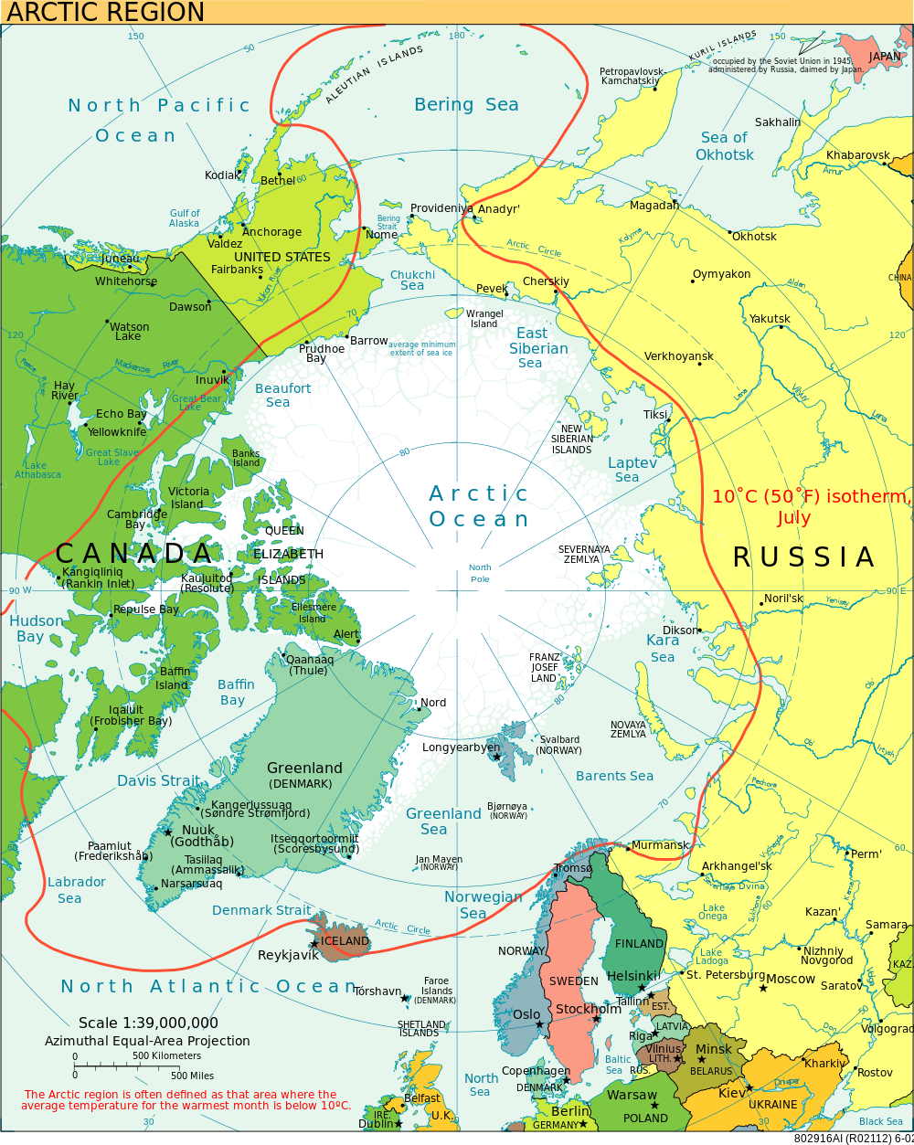
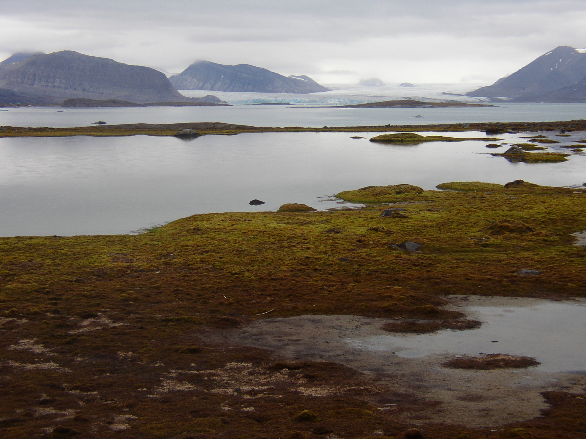
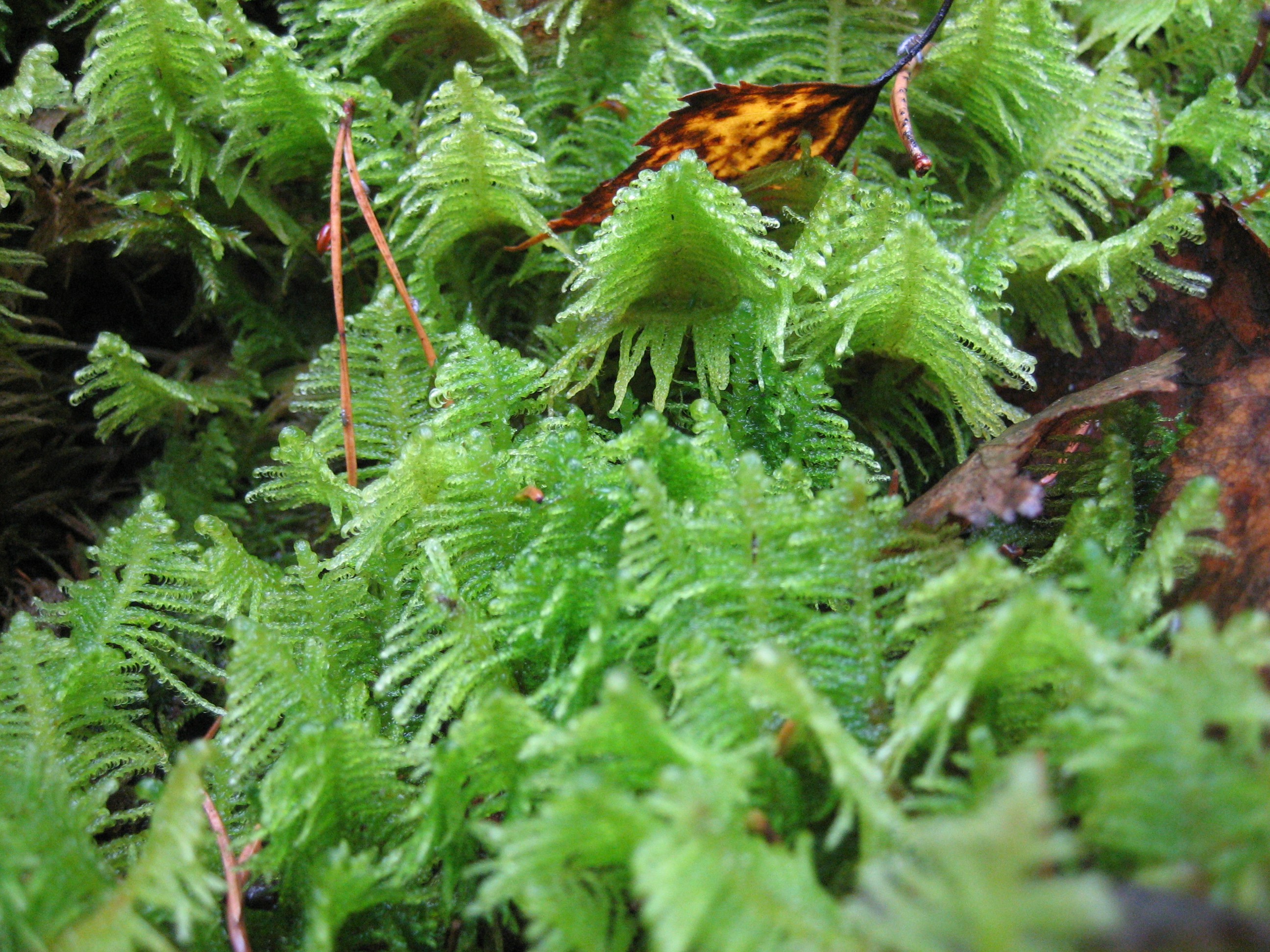
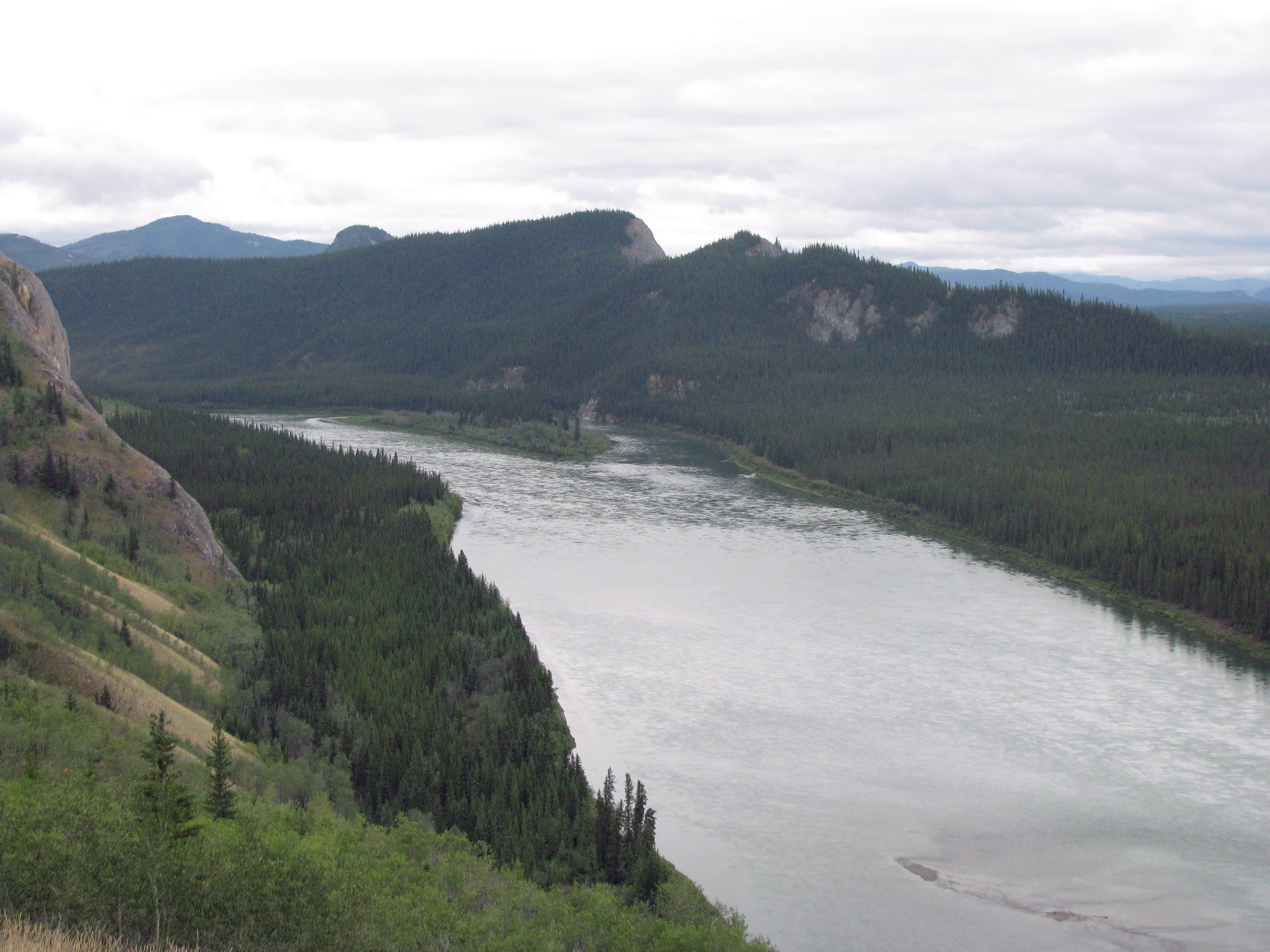
| | | | Comments on Climates As I review the Köppen Groups, I’m rather amused by my experience within the last year or so: Group A, Tropical Rainforest, on the Amazon; Group B, Desert Climate, in the Australian Outback; Group C, Temperate, in Florida. But as mentioned, it’s Groups D & E that are of present significance. | | | | Moving toward the North Coast on the trip to Churchill, both New York and Toronto are Dfa, Hot-Summer Continental, Winnipeg would be Dfb, Warm-Summer Continental, and Churchill would be Dfc, Subarctic Continental/Boreal/Taiga. We will concentrate on Churchill in the Subarctic surrounded by a taiga landscape of boreal (northern) forest. Remember, it’s the vegetation, the flora, that defines climate zones. | | | | In Group E, while we discussed the Ice Cap Climate of Antarctica sufficiently in 2006/15, we will discuss the Arctic’s Tundra Climate in relation to past stops in Spitsbergen in the Arctic (2006/6) and, fleetingly, to South Georgia Island and the Falklands on the edge of the Antarctic (both in 2006/15). All are characterized by a tundra landscape, with its LACK of major vegetation. | | | | I have three detailed Köppen maps covering the “top of the world”. This one of Asia (Map by Peel, M. C., Finlayson, B. L., and McMahon, T. A., University of Melbourne) shows the gray Arctic and tundra area, followed by the green Subarctic and taiga area (interrupted by the colder zone). The blue tones going SE toward Vladivostok (near Korea) are warmer variations of this. This is just the area through which I took the Trans-Siberian Express, and remember being impressed by the boreal forests. | | | | In Europe (Map by Peel, M. C., Finlayson, B. L., and McMahon, T. A., University of Melbourne), the grey Arctic/Tundra diminishes (although still visible in mountain ranges, such as the Alps), but the green Subarctic/taiga area thrives, with its blue variations. | | | | Finally, in our area of concentration, we have North America (Map by Peel, M. C., Finlayson, B. L., and McMahon, T. A., University of Melbourne). Beyond Greenland’s ice cap in dark gray, the Arctic/Tundra area is clear, covering the Arctic islands and northern coast, including about half of Hudson Bay. Churchill on the SW side of the Bay is in the Subarctic/Taiga area, with blue variations southward. | | | | Arctic & Tundra Now that we’ve identified our climactic regions, let’s concentrate on specifics. | | | | THE ARCTIC The Arctic is primarily water, the Arctic Ocean, but includes around its perimeter land areas that are parts of four large countries, Canada, Greenland, Russia, and the US (Alaska), and two small ones, Norway and Iceland. Some like to define the Arctic as simply the area within the Arctic Circle (66° 33'N), the limit of the midnight sun and polar night. To me that seems too mathematical, and doesn’t take the actual geography, flora, and fauna properly into consideration. Using Köppens temperature parameter instead, this is the area of the Arctic (click to enlarge) as determined by the area enclosed by the 10°C (50°F) July isotherm. The northernmost tree line roughly follows this isotherm, so it aligns with using vegetation as a definition of climate zones. Note that, by this definition, the Bering Sea down to the Aleutian Islands is included; that only the upper portion of Hudson Bay is in the Arctic, leaving Churchill in the Subarctic, and that Norway’s Svalbard, including the island of Spitsbergen and its capital of Longyearbyen, snuggle up to the 80°N latitude, which is the furthest north I’ve ever been, and is well into the Arctic. | | | | Since the Arctic is an ocean surrounded by land, the climate is moderated by the ocean water, which can never have a temperature below −2°C (28°F). This relatively warm water, even though it’s covered by the polar ice pack, keeps the North Pole from being the coldest place in the Northern Hemisphere (see eastern Siberia above). On the other hand, Antarctica is a continent, and being a land mass, is much colder than the Arctic (see Ice Cap Climate above). | | | | TUNDRA A biome (or ecosystem) is a system of climatic conditions affecting a community of plants and animals. Tundra is a biome where tree growth is hindered by low temperature and a short growing season. The word tundra comes from the Russian тундра. In the tundra biome, trees can only occasionally appear and survive, in scattered form. The boundary between the tundra and the forest is called the tree line. The vegetation that can normally appear and survive in tundra, given the low temperature and short growing season, consists of dwarf shrubs, grasses, mosses, and lichens, all growing low on the ground or on or near rocks. | | | | The subsoil of tundra is permafrost, or permanently frozen soil. As seen in this distribution of tundra, its largest areas are north of the taiga belt in northern Russia (hence its Russian name) and Canada. It also exists, surprisingly, on islands near Antarctica that are far enough away to not be affected by its ice cap: South Georgia Island and the Falklands. | | | | My personal experience with tundra is primarily with Spitsbergen, where we walked around on shore, but also with Norway’s North Cape, South Georgia, and the Falklands. Tundra is frozen for much of the year, but in summer you can see areas of stark, yet beautiful, landscape, as in this scene in Spitsbergen. Note particularly the vegetation. | | | | Subarctic & Taiga Between the Arctic to the north and the temperate forests to the south is the Subarctic, with its characteristic landscape of taiga. | | | | THE SUBARCTIC The Subarctic (click to enlarge) is a region in the Northern Hemisphere immediately south of the Arctic. It covers areas of Russia, Mongolia, the US (Alaska), Canada, Iceland, Norway, Sweden, and Finland. The subarctic climate is also called the boreal climate, “boreal” meaning “northern” (as opposed to austral), or the taiga climate. It’s characterized by long, usually very cold winters, and short, cool to mild summers. It’s a continental climate, found on large landmasses, away from the moderating effects of an ocean. | | | | While the Arctic is an ocean surrounded by land, allowing for a Subarctic land area, the Antarctic is just the reverse, a continent surrounded by water, the Southern Ocean, with no land area to account for anything that could be called the “Subantarctic”. | | | | TAIGA Taiga is pronounced like “tiger” without the R, although in the original Russian, тайга́ is end-stressed: tai.GA. It should not surprise that both the words tundra and taiga are Russian, given the size of Russia and how much of its landscape is involved in these two biomes. | | | | The taiga biome is characterized by coniferous forests, dominated by larch, spruce, fir, and pine. After the ice cap climate and tundra climate, it’s the land biome with the lowest annual average temperatures. As seen in this distribution, taiga is the world’s largest land biome, making up 27% of the world’s forest cover. The largest taiga areas are in Russia and Canada, but taiga also covers parts of Norway, Sweden, and Finland; the northern parts of Kazakhstan, Mongolia, and Japan (Hokkaido); Alaska; northern Minnesota, Wisconsin, and Michigan; northern New York; Vermont, New Hampshire, and Maine. From these latter entries it would become obvious that, what we referred to as the North Woods in 2011/24, is taiga. | | | | In some ways, taiga represents a transition between tundra further north and temperate deciduous forests further south. Taiga soil is poor in nutrients, since it lacks the organic enrichment deciduous forests offer. In the cool, moist climate, fallen leaves and moss can remain on the forest floor for a long time, not contributing to the soil. The soil is acidic due to falling pine needles, and the forest floor has only lichens and mosses growing on it. Grasses try to find some sun to grow in; lichens and mosses live on the damp taiga forest floor and on tree trunks. | | | | This typical taiga landscape is on the Yukon River in Yukon. | | | | Naming the Arctic The North is “bear country” for two entirely different and unrelated reasons, only one of which is polar bears, and that’s not how the bear connection got into the name. The bear reference was to the two constellations, Ursa Major and Ursa Minor. Ursa Major is best translated as “Larger Bear”, but “Great Bear” is also used. It’s the most prominent northern constellation. Ursa Minor is best translated as “Smaller Bear”, although “Little/Lesser Bear” is also used. It’s the most northern constellation. In both cases, it’s a female bear (ursa) referred to, not male (ursus). | | | | Start with the Greek word for “bear”, arktós / αρκτοσ (perhaps easier to read when all in capitals: ΑΡΚΤΟΣ). Add to the root αρκτ- the suffix -ikos / -ικοσ which is the same as “-ic”, and you have arktikós / αρκτικοσ (ΑΡΚΤΙΚΟΣ), whose meaning now becomes metaphoric and means “northern”, “of the bear (constellation[s])”. We can picture “Arctic” as being like “bear-ic”, “bear-ish”, “having to do with the bear(s)”, (in the sky, not the white ones on the ground and on the ice). | | | | Perhaps some people think that “Antarctic” is as “positive” a name as “Arctic”, but that doesn’t seem true. The name doesn’t tell what it IS, it tells what it ISN’T. In modern languages, as well as Latin and Greek, “anti-” can shorten to “ant-” before a vowel, so a reconstructed Greek antarktikós, is the anti-Arctic, which appears as Antarctic, or “opposite the Arctic”. Therefore, its name, rather than referring positively, perhaps, to a southern constellation, refers negatively as “anti-northern” “opposite the north” or “opposite the bear (constellation[s])”. Isn’t that rather convoluted? | | | | By the way, centuries ago, the root arct- shortened to simply art-, and the C was quite logically also dropped in spelling. Modern spelling restored it in about 1600, simply for historical purposes. Still most English speakers usually still SAY Artic and Antartic, and only rarely feel compelled to say ArKKtic and AntarKKtic. | | | |
| |
|
|
|

