|
Reflections 2016
Series 9
May 12
Visiting the Northwest Angle - Back to St Paul & New York
| | Going to the Northwest Angle had been on my bucket list for a long time, and now was the chance to do so, just for a couple of nights as a side trip north out of Bemidji, the day after visiting Lake Itasca. As with everything, it had been well-planned, and worked out very well. The few people I met were friendly and helpful. | | | | Yet, the experience was unusual. I suppose even from the planning stages it seemed different from other travel, a little weird, a little odd-ball. Because of that in retrospect I feel I can say there was a certain malaise that permeated the two days. There were a lot of little things. One was that the international border crossing was unlike any I've ever done before—and I've done more than my share of them. The region visited was so very remote, more than I'd realized. There was also an ongoing feeling of loneliness for those two days. The entire area was of such low population, and that was creepier than I thought it would be. Such loneliness is particularly unusual for me, since I am and always have been a loner. I meet with friends regularly, but am perfectly comfortable living alone, working online for days at end. I'm also perfectly comfortable traveling alone, meeting people along the way. While I'm also usually a solo diner in restaurants when traveling, even then I'll often get talking to people. Still, this loop trip seemed a lonesome experience. | | | | It started some six months earlier in the planning stages. I knew that where I was going was heavily frequented by fishermen, yet everything I read said there was nature and wildlife to enjoy as well, and when not fishing, people could go around and do other things. Well, that wasn't really so, and I felt like a fish out of water—pun most definitely intended. | | | | The route was easy to plan, and I learned about the peculiar border crossing. What I was looking for was (1) a place to stay, and (2) a boat ride to get to see that northwesternmost pinpoint, which tends today to be referred to frequently as the northernmost point, a more up-to-date way of looking at it, while the older term is more historic. I really wasn't looking for much beyond that. | | | | The internet does wonders for finding these places. What I noticed was that everything physically on the Angle was located along its north shore, literally on the south side of Angle Inlet, opposite Ontario on the north side. But I also learned why the local Chamber of Commerce refers to the area as the "Northwest Angle and Islands". While most of the islands in Lake of the Woods are Canadian, two larger nearby islands, Flag Island and Oak Island, plus a few islets, are on the US side of the water border, and there are accommodations not only in the Angle itself, but on these islands. Talk about the remotest of the remote. Furthermore, just about every one of these places uses words in their name like "resort, lodge, camp, outpost". What was I getting into? | | | | I certainly didn't want to be on one of the islands, but I wanted to be as far out (east) on the Angle as possible, and on Young's Bay I found family-run Young's Bay Resort. I want to emphasize in all this that it was a delightful place and I enjoyed my stay there, within the parameters of the ongoing feeling of malaise. When I called and spoke to the young woman who managed the resort, she explained that early October would be low season. They're very busy in the summer, and even moreso in the winter, with ice fishing, but there wouldn't be many people there when I was there. That a hotel is not full is normally not a problem, but that did add to the emptiness of the area. | | | | Should you be interested, their website is www.youngsbayresort.com, but I'll be including many of their photos within the posting. What I found online is that they have seven cabins in five buildings, two being duplexes. I could see that paired Cabins 4 & 5 were smaller despite their still being for four people each, so I arranged to be in Cabin 4. Interestingly, the October rate was still part of the summer rate, $35 per person, in winter $55, so you can see the winter is really the high season. Of course that wasn't final—my rate was for a minimum of three people (winter minimum two), so my cabin for four would include three ghosts, two of which I'd be paying for. Oddly, the down payment is only $20, apparently about half of the single rate. In addition, they take no credit cards whatsoever. The $20 deposit was to be mailed as a check, and they otherwise have an ATM on the premises. I asked about a restaurant, and they said they had one, but I was highly dubious of how well that would work in low season. So, since the cabin had a kitchen, I decided to stock up on food in Bemidji, and also on gas before even crossing into Manitoba and the Angle. I'm giving these details to sketch out the location and to show how different it is from my usual getting a B&B or hotel room. | | | | Since there was no information about boat rides, I asked the manager. At best, there were people who did full-day fishing tours including a picnic lunch. Actually, this was reminiscent of my problem in the fishing resort of Venice, Louisiana, last year when I wanted a ride to the mouth of the Mississippi, and fortunately, found one, despite everyone else being a fisherman. At Young's Bay, the manager put me in touch with Deb Butler, who's run a water taxi service for a number of years. I called her, and we decided she could do for me what I needed, at an hourly rate. As it turned out, one hour was all I needed to see what I wanted. | | | | So in Bemidji that evening, after dinner, I set out to buy groceries—the last time I did that on a trip was when I was at Allan's house in Annapolis Royal, Nova Scotia for a week. If I'd been in a walkable part of Bemidji, down near the statues, I could have easily gone shopping on foot. But here in the newer, auto-friendly part of Bemidji—and I say that negatively—I'd checked out in advance on Google Maps that there was a huge supermarket right across from the hotel, Lueken's Village. But walking wouldn't be easy because of the four-lane highway between it and the hotel, plus the large hotel parking lot and market lot. What a way to live! | | | | I had to drive from the hotel parking lot to the next corner to make a U-turn to enter the market parking lot—so near and yet so far. I got some sandwiches and supplies, then found it was raining when I had to reach the car. It was just one more bother leading up to my malaise, and at that point, I hadn't even thought of the affect of rain on dirt roads.
http://www.minnesota-map.org/minnesota-road-map.gif
| | | | Day 24: Bemidji to the Northwest Angle; Angle Inlet 1 The new day was rain-free, but largely overcast, which didn't help the mood. Look again at the above Minnesota map (click) so we can all follow the loop route we'll be taking, which will involve both sides of Red Lake, which is the largest natural freshwater lake entirely within Minnesota. You see the peninsula that almost separates it into the Upper and Lower lake. Lower Red Lake lies entirely within the Red Lake Indian Reservation, home to the Red Lake Band of Chippewa, where Ojibwe is the official language. | | | | From Bemidji, follow Highway 89, which swings around the lake, with occasional views. It's only just over a couple of hours to Roseau and the international crossing just north of it, open days only, 8-24.
When we return after two nights, we'll re-enter via Warroad, the major crossing here, open 24h. We'll then swing over to Baudette to see the Rainy River, and then take highways 72 & 71, which, after getting us nice views of Upper Red Lake with wild rice in the foreground, will take us back to Bemidji, where, via Cass Lake, we'll go to Walker to spend the night on the shores of Leech Lake.
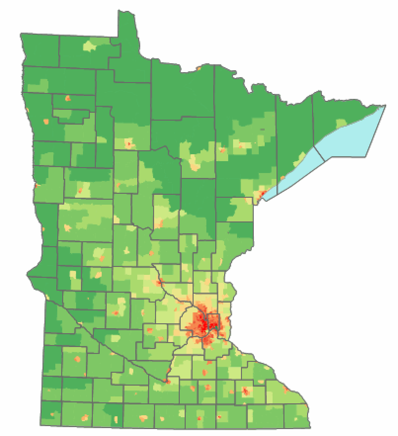
| | | | But the farther north we go, the fewer people there are here in the North Woods, as this map of Minnesota population distribution shows (Map by Ravedave). Nearly 60% of the state's population lives in MSP, and the darker the green, the fewer people. You can tell that central Minnesota, where we've been, has more people than northernmost Minnesota. I almost feel that we can distinguish now between "up north" and "way up north" (my term).
http://www.nativecanadian.ca/images/Reserv2.gif
| | | | I also offer this map to show population. I've driven across Canada on the Trans-Canada Highway, portions of which are shown here by maple leafs, and I know how sparsely populated western Ontario is. On this map, that seems to carry over to the Angle, and into easternmost Manitoba, but then note how many roads indicate population centers in Winnipeg and its surroundings. Winnipeg is only about two hours or so from SE Manitoba and the Angle, but population-wise, its region is a world away.
http://www.angleinnlodge.com/images/map2.jpg
| | | | The best map I could find is above giving directions to Angle Inn Lodge on Oak Island. Young's Bay Resort is at the end of the mainland, but the directions are still valid. So here we go. We've passed Lower Red Lake, then later passed Roseau on 310, and right after that, we cross the border. This crossing, and the Warroad crossing later, involve the real border (my term), the 49th parallel. We'll come to the unusual (to my way of thinking) Angle border shortly. We turn onto 12 (unnamed) and zigzag onto 308 to the town of Sprague, which is small, quiet, and very residential, with the only visible business being a gas station at the T-intersection into town. 308 remains paved until about halfway to the Angle border, then becomes gravel and/or dirt. I'd known this in advance, but didn't yet know that all the roads in the Angle are also unpaved. The loss of paving is another indication of leaving civilization as we know it. And now, we reap the results of last night's rain. While driving on the road is not difficult, the car now acquires a mud skirt halfway up all sides, including in the wheel wells. Welcome to rural Manitoba, and, shortly, the Angle. We turn onto 525.
https://farm3.staticflickr.com/2845/13750567594_9bd75799d0_c.jpg
| | | | We soon arrive at the N-S border to the Angle. Notice the unpaved road, and don't miss the mud splattered on the sign. I remember reading somewhere—I don't have the exact quote—that this road connection via MB only dates from the 1970s. This means that, when I first learned more extensively about MN geography on the wedding trip in 1962, the only way to reach the Angle was via the lake (or air—note the float plane on the map). | | | | If you have a good sense of direction, you may also feel how unusual it is to cross between Canada and the US in an E-W direction. But there's more to it than that. No official agent is at the border (no surprise, we did our homework and knew it in advance). Still, we pull to the side at the border and look north (!) for this border view (Photo by Jidanni). MB is on the left, MN's Angle on the right, and well north of here, this continues to be the border between MB and ON. Apparently, according to regulations, trees are cut to maintain a line of sight all along the border, which explains the clearing in the background. Still, that seems silly here, since the border is not manned. I scrambled all around the geodetic survey marker at the border between countries. In the foreground of this picture, there's apparently some old marker, which isn't there any more. There were no people here when I was, although a car passed me by into the Angle, which is probably the first car I saw since the "real" border. | | | | While the border is unstaffed on either side, that doesn't mean you don't have to report in. Check the map again. Once the road enters the Angle, it turns north to a T-intersection with the cross road that goes left to the village of Angle Inlet and right (all the way, not shown here) to Young's Bay in the east. At that T-intersection is a shack called Jim's Corner. I don't know who Jim is/was nor what makes it his "corner". But for those who were unaware, this other border sign gives more information.
http://i1.wp.com/amateurtraveler.com/wp-content/uploads/2011/07/P10707551.jpg?resize=500%2C393
http://file2.answcdn.com/answ-cld/image/upload/f_jpg,w_672,c_fill,g_faces:center,q_70/v1/tk/view/cew/3/8/0/2/8/3802807211/0fcb0df236855654db105a85b444f20096666b01.jpeg
| | | | If you like, watch this short (1:01) YouTube video of the border crossing. Obviously, I'm not the only one to think it odd. Otherwise, after about 15 minutes, you arrive facing the back of Jim's Corner, as in the second photo. It's a shack about the size of a walk-in closet. Note the arrow pointing east to Young's Bay Resort and many others, the preponderance of words such as "resort, lodge, camp" in their names, and the Island Passenger Service, which is Deb Butler's water taxi. Welcome to the Angle, deeper into the North Woods than I'd expected to ever be. | | | | Once you pull around to the front of Jim's Corner (Photo by Alanjj) (entry road ahead, town to right, Young's Bay to left) you see how simple it is. Click to confirm where it says that the area is officially the "Northwest Angle and Islands". It's busier in this picture, so it must be summer, but actually, I did cross paths here momentarily with a group of three fisherman who were just finishing checking in to go back into Canada, so I knew there were human beings around. | | | | Inside Jim's Corner there's a phone with two buttons, one with a US flag, one Canadian. I pushed the US button and a scratchy voice spoke to me with static (it was no better two days later on the Canadian phone). You're told to say something like "I'm reporting my arrival in the US from Jim's Corner, NW Angle", and when returning "in Canada". I have to assume I was speaking to an agent at Warroad, since that's the major "real" crossing. I was asked my name, birth date, nationality, and car license number. Nothing more. Not an address to know where I was from, and most surprisingly, not a passport number or even driver's license number. | | | | Here's a very short YouTube video (0:20) at Jim's Corner. But things were even stranger. That earlier sign had said there was a videophone. This video shows one as well. I did not have a videophone in front of me, and if one was there, it wasn't operating and had a blank screen, so the scratchy voices I talked to in each country were even more ethereal. But I was finally in. Legally.
http://amateurtraveler.com/wp-content/uploads/2011/07/P1070758-500x375.jpg
https://c3.staticflickr.com/7/6187/6079570486_0dd60f2313_z.jpg
| | | | Now what can you do if you don't fish? I decided to go a bit west from Jim's Corner into the village of Angle Inlet. Houses were very sparse, but the Angle Inlet Post Office is easily found. It's again about the size of a walk-in closet, but the sign points out that it's the "Most Northerly PO in the Contiguous US". Actually, the most distinguished-looking building I found in the whole Angle was the Angle Inlet School (elementary), which is part of the Warroad School District. It's colorful playground is the brightest spot in the Angle. It's one of the few remaining one-room schoolhouses in the US.
http://www.youngsbayresort.com/data1/images/aerial_photo.jpg
| | | | In a moment we're back passing Jim's Corner again and another 15 minutes gets us to the end of Young's Bay Drive at Young's Bay and Young's Bay Resort (above). It was totally deserted. I had easily found my cabin #4, and parked next to it, then walked up to the store. The manager had told me she picks up her son at the school in mid-afternoon, and so the store she works out of was locked, so I felt I had to wait. The resort faces east, so we arrived in the back of the photo. There's so much parking ($2 a night) because people going off to the islands leave their cars here. I think that low building on the left is the restaurant, but it didn't look inviting, especially during low season, so I was glad I had my groceries. In the front area is the dock, then the store, then the marina, which is protected by an area of wild rice, for which Minnesota is famous. I had an overview of water and wild rice from my cabin, and the picture shows the brown cabins lined up behind the marina. | | | | | | Wild rice, a grass and its seeds, is not directly related to Asian rice. It grows in shallow water, such as here in the Superior National Forest—and outside my cabin window. Also, gardeners use it as an ornamental. I learned to eat wild rice in Minnesota. Cooked wild ride looks like this (Photo by ElinorD), although I prefer it blended with Asian rice. |
| | | | As I was waiting on the steps leading up to the store, a middle-aged man approached me. He was Human Being #1 (HB1) that I spoke to at any length during this side trip. Let me show you where we were:
http://www.youngsbayresort.com/images/marina2.jpg
http://www.youngsbayresort.com/images/store.jpg
| | | | The first link shows the dock and launching area looking out toward the lake. Right to the left is the Young's Bay Resort Store. I was standing on the steps, wondering why the building was raised up—so were the cabins—thinking about buildings on the Gulf Coast raised for fear of hurricanes. But it struck me that in the winter, raising buildings like this keeps them out of the deep snow! This is not only Minnesota, this is the Northwest Angle! | | | | I mentioned the remoteness, and HB1, whose name I never got, says he comes up here all the time, about a half-dozen times this past summer alone. I didn't ask just where he was from, but in greatest likelihood, he was from The Cities, and this rather distant location was his spot Up North. When I mentioned the mud, he told me he avoids coming right after the rain for just that reason. Well, a regular would know that, but in a four-week tightly scheduled trip, I had no such flexibility.
http://www.youngsbayresort.com/images/marina.jpg
http://www.youngsbayresort.com/images/cabin4_5/Cabin%204%20Outside%20View.jpg
http://www.youngsbayresort.com/images/cabin4_5/Cabin%205%20Porch-1.jpg
| | | | The first link is to the view of the marina from the store, with the cabins on the left and the wild rice on the right. We walked past that and came to twin cabins 4&5 (second link), the smallest ones, for four people each, with a common screened porch. Mine was the closer one here, #4. Note how it's raised above the ground. Given its rural look, it's really quite nice. The third view shows the common porch, from the opposite side. You can see the back of the store, and the marina. | | | | We walked up to my door, he turned the knob, and, to my surprise, we walked in. It was at this point that he—a guest, not an employee—pointed out that "we don't use locks here". A revelation. Then he pointed out as he left that she'd turned the heat on, so she must have been expecting me. And so things do get resolved.
http://www.youngsbayresort.com/images/cabin4_5/Cabin%205%20Living%20%26%20Kitchen.jpg
http://www.youngsbayresort.com/images/cabin4_5/Cabin%205%20Bedroom.jpg
| | | | This is Cabin 5, so mine was the mirror image, but right behind the porch (to the right), is the common room, basically a living room, dining room, and kitchen. To the right of that is a row of three rooms, the bath, and two bedrooms with two beds each and a chair. It all was quite comfortable for such a rural setting—you can see the dark knotty pine paneling everywhere. You can just picture four fishermen friends being comfortable here. I, however, had three ghosts, two of which I was paying for. | | | | Fortunately, the wifi was perfect, so I settled in, did some writing online, and admired my water and wild rice view. After a while, I went to find the manager, who was Human Being #2 (HB2) here. She was behind the store counter, and very pleasant. Her little boy was drawing with crayons at a nearby table. The store was like a convenience store you'd find at a gas station, heavy mostly on potato chips and such (particularly now in low season), with some refrigerated items, fishing gear, sweatshirts and tee-shirts. Still, I was glad I'd carried in my own supplies, and so I returned to my cabin, wrote, had dinner, and thus ended the day. You will have to admit, this was not a usual type day I describe, and neither was the second day. | | | | Day 25: Angle Inlet 2 Human Being #3 was the only one whose name I knew, since I'd planned to meet Deb Butler of Island Passenger Service at 9:00 for my boat ride. I was waiting at the pier when I saw her boat enter, but pull over to the marina. When she came back, she explained she'd brought a couple in from an island, and the woman was ill. I commented about how isolated this area is, and her point was that you have to balance risks with the pleasure of living here. Maybe.
http://2.bp.blogspot.com/_oMrDt2JRVTk/TUx_5NhnMzI/AAAAAAAABV8/LHmKd9JLY7Y/s1600/Screen+shot+2011-02-04+at+5.37.11+PM.png
| | | | Deb's boat was small, and I sat in the passenger seat to her left as we went for our ride. It was chilly, though sunny, in early October this far north, and I appreciated the plastic shields all around the low cab we were riding in. She turned into Angle Inlet (see map) and I knew just where we were after a few minutes when I saw through the trees on my left the colorful playground equipment at the school in town. As we went along, Ontario was on our right, and it wasn't too long until we were close to the Northwest Point. Manitoba was straight ahead, where MN and ON came together to just touch it. She stopped the boat when she said she didn't want to risk scraping bottom, but asked if I wanted to go any further. I saw the white buoy up ahead, and was satisfied. I'd seen Benjamin Franklin's pinpoint, the basis for the Angle's existence, and the northernmost point in the continental US. (I know, I was further north in Churchill MB! But still!) | | | | I learned more from Deb about the area than from anyone else. (But who was there to talk to, anyway?) I found out that kids beyond elementary school age go to school by bus in Warroad; they sleep when going and do homework returning. Electricity comes to the Angle from a Roseau company via an agreement with a Manitoba company. Anyway, I hadn't known how much time it would take to see what I'd wanted to see. As it turned out, an hour was sufficient, and to fill the hour, we pulled out of Angle Inlet and encircled Flag Island and saw Oak Island, including Deb's home which I think was on Flag. | | | | I'd heard about ice roads, but had difficulty picturing if they really existed. When I rented the car in St Paul, I mentioned I was going to the Angle to the young man who picked me up at the hotel, then did the paperwork in the office. I was surprised when he said that not only did he often go to the Angle, he usually went in winter, and avoiding Canada, by driving his car across Lake of the Woods on an ice road. I knew lakes froze in the northern winter. I could understand people walking or skating on the ice, maybe even riding on a snowmobile, but had difficulty picturing people actually driving a car or truck over ice, and for several hours to a distant location, to boot. Well, for Deb that was old hat. She said ice roads are not government-built. Residents and resorts in the Angle pay $350 a season to have an ice road privately plowed and maintained connecting to the southern end of the lake. I've also found that there are other ice roads, such as up to Kenora ON on the north side of the lake. So I went searching for pictures:
http://media.twnmm.com/storage/18219644/1085
https://shawglobalnews.files.wordpress.com/2015/01/ice-road-lake-of-the-woods.jpg?quality=70&strip=all&w=720&h=480&crop=1
http://storage.torontosun.com/v1/dynamic_resize/sws_path/suns-prod-images/1297653945542_ORIGINAL.jpg?quality=80&size=420x
| | | | This first one shows a beautiful bright and sunny day out on the ice road on Lake of the Woods. The second one shows gloomier weather, but this is a route a boat would be taking in the summer. But oops! The third one was from a Kenora newspaper, telling about how a Kenora couple rescued a family stranded on the ice road after their truck broke through the ice on a major ice road south of Kenora.
http://www.sunsetlodgeresort.com/uploads/1/5/3/2/15323020/2913906_orig.jpg
| | | | Now that we're talking about ice roads, I'll show this map, and you'll understand that red line. Angle Inlet is at the top left, where the border is indicated. Young's Bay, where we started out, is shown. You also see the US islands, which are a couple of small islets, then Flag, that we went around, and Oak that we saw. The reason I waited until now to show the map is that the map comes from the website of Sunset Lodge on Oak Island, from which I copied this information: For driving directions, use Young's Bay Resort . . . . It takes about 10-15 minutes to drive (winter) or boat (summer) from Young's Bay to Sunset Lodge. . . . In the winter months, Sunset Lodge is accessible by vehicle on plowed roads from Young's Bay directly to our front door. . . . [Y]ou drive around Jerry's Bar to the right where you will get on the ice road. Once on the lake head to your right and then you will begin seeing signs for Sunset Lodge! You can also arrive by snowmobile from either Young's Bay or the south shore of Lake of the Woods.
http://426ijy9zj7l114g7e292hi14.wpengine.netdna-cdn.com/wp-content/uploads/2015/01/Traveling-the-ice-road-from-Youngs-Bay-Angle-Inlet-Mn-to-Flag-Island-Lake-of-the-Woods.jpg
| | | | It boggles my mind. It sounds like you'd drive right off the dock and onto the ice. And I cannot understand the above picture. The caption says it shows traveling the ice road from Young's Bay to Flag Island (the closer of the two), but it looks like the ice is melting! If it had, hopefully it refroze. But would you do this?
https://i.ytimg.com/vi/-f-ucZvW5-g/maxresdefault.jpg
| | | | Finally, look at this picture of the tail end of a pickup truck that was traveling on an ice road six miles from shore (!) on Lake of the Woods too late in the season, and broke through the ice. If you want to see more, this is a short (1:00) YouTube video of the actual sinking. | | | | Our boat ride took just over an hour, and as I paid Deb—cash of course, this is the Angle!—she finally admitted after our phone conversation months ago and after the hour's ride, that she though it a little odd that I'd be willing to come this far and pay for a short boat ride like that. I still enjoyed what we did, but was disappointed that she didn't fully understand my travel motivation in this situation. | | | | It was still early, just late morning. If I'd thought it would be over so quickly, I could have planned just one night here, but, given the distance and effort, a day's rest wouldn't hurt, either. I went back to the cabin and wrote online during the afternoon. Later on, I went to the store and got cash out of the ATM to pay my "hotel" bill, so I could leave promptly in the morning. | | | | Day 26: Angle Inlet to Walker After admiring one more time over breakfast my view of the inlet and wild rice paddy, I was on my way. I stopped at Jim's Corner to talk to Canadian immigration, then crossed the N-S border one last time. After a while, I hit the paved road again, and felt I was returning to civilization. Sprague, too, was a step upward in events. After that, I turned east to the crossing at Warroad, and even then, felt that the Canadian side was unusually quiet as compared to the activity on the US side.
http://www.lakesnwoods.com/images/Lakeof79.jpg
| | | | On this map, you see where 313 hits 11, the main road. Right there was Varsity Car Wash, which I eagerly took advantage of, so I know I wasn't the first one to appear in Warroad with a mud skirt on the car. Right behind it was Warroad High School, so I also knew just how much of a ride those kids have—it took me 1h20. And even without a map, not far away I found Lake Street, which led to Lakeview Park, which gave me what I wanted to see, the view from the southern edge of Lake of the Woods. I don't know where the ice roads leave, but there was a boat launching ramp here which seemed like a good candidate. | | | | Years ago, on a trip along Lake Superior to Thunder Bay ON, I crossed the border over the Pigeon River. This time I didn't want to leave this area without inspecting more of the lake, but I also wanted to cross over the Rainy River into Ontario. In addition, doing this formed a nice part of the loop we're taking out of Bemidji. As we ride along the lake, take notice on the map of the small communities of Swift, Roosevelt, Williams, Graceton, and Pitt for reference below.
https://johnsavageau.files.wordpress.com/2010/02/baudette.jpg
| | | | Baudette, above, is a nice enough town. I drove across the small, attractive Baudette River to check out the layout of the town. Then I took the bridge (adjacent to a rail bridge) into Ontario. When the Canadian agent asked where I was going, I said to Rainy River (see map). She raised her eyebrows and made it clear that there was nothing to see there. Sometimes people just don't understand. I looked around the town, and then found historic markers telling about the Great Baudette Fire of 1910, including a sign next to an old locomotive that had shuttled people during the fire between Baudette and Rainy River. Clearly, serendipity had found an interesting event. | | | | The Baudette Fire of 1910 was a wildfire in the North Woods that left 42 dead. It started on 4 October and entirely consumed Williams and Graceton, then Pitt (see lake map). At the time, Baudette had a twin town across the Baudette River called Spooner. The fire approached Baudette and Spooner on the evening of 7 October and entirely consumed them both, including the bridge connecting them. Spooner, like some other towns nearby never recovered, and eventually merged with Baudette in 1954. | | | | The fire jumped the border and heavily damaged, but didn't destroy, Rainy River, plus two smaller towns to the east. It also spread west, and heavily damaged Roosevelt, Swift, and Warroad, and even continued on to jump the Canadian border there to damage Sprague MB. Rainy River's residential area was not affected, and residents welcomed people from Baudette/Spooner into their homes for quite some time while their homes were being rebuilt. | | | | I crossed back over the border to a US agent who also thought border-hopping was odd, but pointed out a marker in a nearby park in Baudette that also spoke of the fire. After that, I suddenly had an urge to celebrate my return to civilization with brunch. I went back into Baudette on West Main Street and found Alice's Family Restaurant, a large diner. I had something simple like waffles and coffee, but the interesting part was chatting with the waitress in the almost empty restaurant, who was Human Being #4, the last person I conversed with on this side trip. She told me how she came to work up here in the north, and it turns out she was originally from Bloomington, where Beverly was from, so that was another common topic. | | | | Afterward I went east on 11 (see lake map) a bit and then did a right turn south on 72 toward Red Lake. The feeling of malaise was lifting. I've gone back to lots of places—on this trip, St Louis, Hannibal, more--since revisits sometimes have a greater value than original visits. But in the case of the Angle, it was on my bucket list, I've checked it off, and once is enough.
http://www.minnesota-map.org/minnesota-road-map.gif
| | | | We need to go back to this Minnesota map we've used before (click). We drive from Baudette down to Upper Red Lake (the largest entirely within MN), and stop at a viewing area to admire the wild rice paddies and lake view. We zigzag into Bemidji, coming in from the north, and drive past Paul Bunyan and Babe. But we want to go further, and swing toward the town of Cass Lake, then down to Walker on Leech Lake for our booked hotel. There are nice lake views from town and from the hotel grounds. Leech Lake is the third largest in MN. This map details the local area.
http://www.d.umn.edu/cla/faculty/troufs/Buffalo/images/map_res1.jpg
| | | | Day 27: Walker to Stillwater Leaving Walker, we have one additional destination before St Paul, Stillwater MN, on the St Croix River at the Wisconsin border. As it turns out (see MN map), we drive through Pine River on the way. My in-laws used to have their cabin on Jail Lake ("Yale Lake"), a quarter hour NE of Pine River, partially on dirt roads. We then reach Brainerd, where we cross our northbound route of several days ago. Continuing east, we come to Mille Lacs (pronounce the S in English—it rhymes with "relax"). A little knowledge of French will tell you that Mille Lacs is a "Thousand Lakes", so it is Minnesota's second-largest inland lake and so we make the three-lake trifecta, the three biggest inland lakes in MN in just two days. We pull up to a viewing area on the lake where the morning sun makes it look just perfect.
| | | | We cut east on 95 through Princeton and Cambridge to reach the St Croix River (rhymes with "Troy") (Map by Kmusser), the border between MN and WI. Today and tomorrow we'll follow the St Croix to its confluence with the Mississippi, then return to St Paul.
http://www.lakesnwoods.com/images/Taylor3.jpg
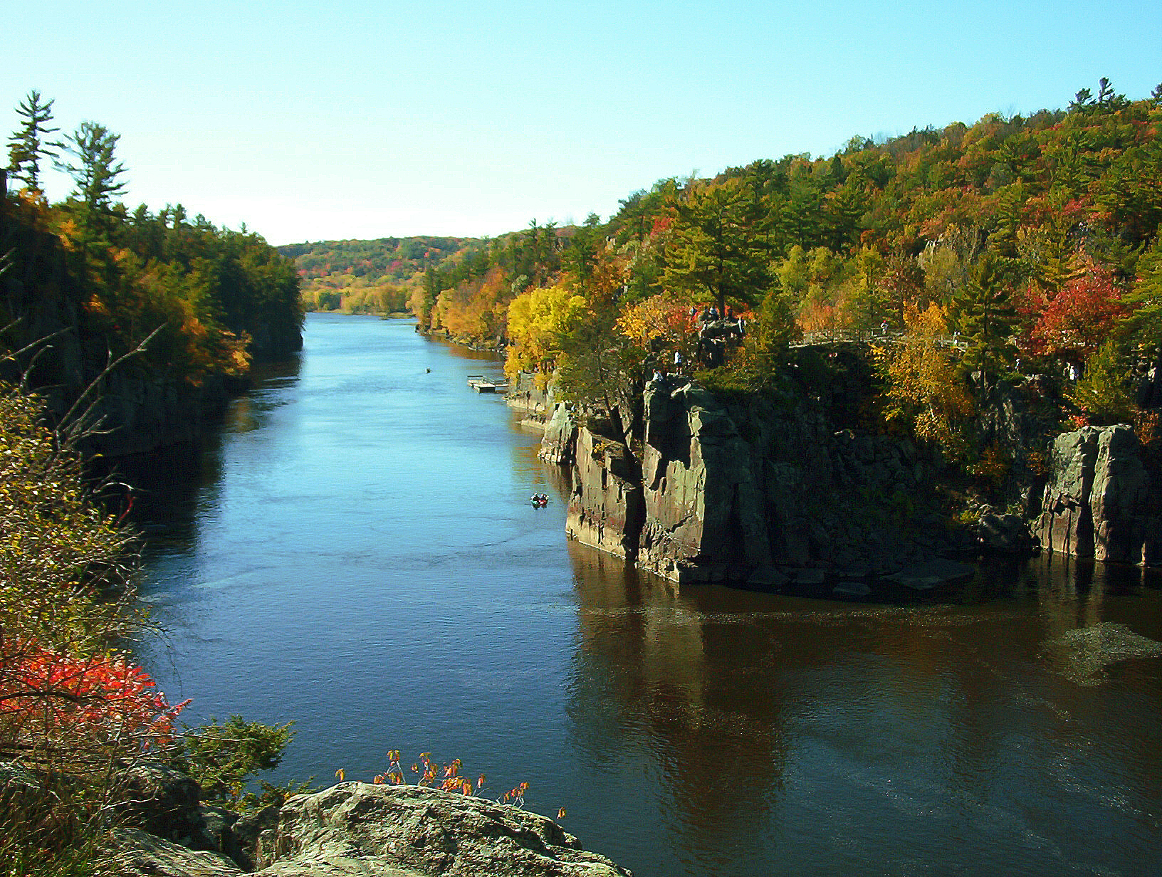
| | | | Highway 95 is seen better on this detailed map of the area, showing where 95 takes us to the river, then along it to Stillwater. Our first stop is Taylors Falls, which I've visited in the past to see the rocky gorge along the river, including the Dalles (rhymes with "pals") of the St Croix. (Dalles are river rapids running between the sides of the gorge.) But as we approach Taylors Falls, traffic stops. At first I suspect an accident, but later find out that, for the second Sunday in a row, local events have taken their toll on our itinerary. Last Sunday, the Minnesota Marathon prevented us from visiting Summit Avenue, so we postponed that to our return to St Paul tomorrow. But today, the absolutely perfect, unseasonably warm fall weather and ideal tree color have drawn everyone and his brother out of the adjacent Cities on a Sunday afternoon to the St Croix. As we inch through town, we watch people enjoying life in sidewalk cafés, but don't dare get out of line for fear of not getting back in--and there's no parking anyway. After 50 minutes, we finally reach the offending traffic light where US 8 crosses us and then crosses the river (see detailed map). Knowing we can't stop, we cross over to adjacent St Croix Falls WI and have to be satisfied with views from the car while crossing the bridge. Under better circumstances, these are the Dalles of the St Croix looking south from the bridge (Photo by 123dieinafire) on a fine autumn day (click), and this is probably a view to the north (Photo by Aaron Fulkerson). | | | | But the traffic continued to plague us. Rather than turning back to Taylors Falls, we proceed south on the Wisconsin side to the next bridge at Osceola (see map). But off the bridge, it's impossible to turn left on 95, so we turn right, then make a U-turn. Crazy. Continuing south, we see the river occasionally, then approach Stillwater. Entering town, we have a shorter traffic jam of 30 minutes.
http://www.discoverstillwater.com//wp-content/uploads/2013/04/about-map.jpg
| | | | This is a good map, but is on its side. We enter from the north, to the right. Most of what we want can be done on foot from the hotel, but there's one destination best reached by car, so we zigzag over to Pine between 3rd and 4th to see the former Washington County Courthouse (Photo by Iulus Ascanius). It's another indication of the importance of county courthouses in smaller US communities. It's well located on top of a hill and its grounds cover a full block, so it looks good from all directions. Click to see the details of its Italianate style. When it opened in 1870, the county was doing a booming business in the lumber industry, and the building reflected the county's wealth. Over a century later, in 1975, the court moved elsewhere, so the building is now a community center.
http://www.scenicpathways.com/wp-content/uploads/2013/12/stillwater-1010281.jpg
| | | | It's not far back to the Lowell Inn on 2nd at Myrtle. It dates from 1927 and is a local landmark. Over the decades, I estimate Beverly and I treated ourselves to a dinner there three times, once with her parents, so it's a special destination. This time, I though I'd stay overnight for the first time. But each time we went to Stillwater, it was deserted--we may even have found street parking. But this time, it was like a World's Fair was in town, with car traffic and pedestrians everywhere. I don't know if there was always a parking ramp next door, but there is now, and they validate, so that solved the problem. I checked in, but it was still mid-afternoon, with time to see what I wanted to see, all walkable from the Inn. | | | | I walked around Main Street to admire the architecture, then went to Lowell Park at the river's edge. There were crowds everywhere, and some events were being held in the park, making it more hectic. What I wanted to see was the Stillwater Lift Bridge (Photo by jkmarko), where highway 36 from the Cities (see town map) joins 95 to cross over to Wisconsin. It dates from 1931 and is listed on the National Register of Historic Places. Only once I got to Stillwater did I find out it some changes were in store (see below). Several of us in the crowd watched it open to let river traffic pass, and then I decided, with others, to walk across to Wisconsin and back (Photo by Michael Hicks). This view is from the Minnesota side—click to see the pedestrian lane on the right—and I make it a practice to walk between states as often as I can, particularly over bridges.
http://www.lowellinn.com/wp-content/themes/lowellinn/images/dining/s2.jpg
| | | | But it was dinner time, and I wanted my special meal. Lowell Inn has two dining rooms, but the Matterhorn Room, which dates from c 1959 (above, click), is set aside for fondue of all kinds, and this is where we always had come. The carvings around the room were done by a woodcarving master from Switzerland, Eddie Blatter, who lived in the hotel for three years while he designed and hand-carved the room. | | | | As it turns out, despite the crowds in the streets, Sunday night is not a favored dining time, and there were only three other tables occupied, all couples. The fondue menu is a four-course prix fixe menu, and unlike some places, they offer fondue for a solo diner as well. The first course is cheese fondue, made from gruyère and fontina cheeses, served with pieces of pumpernickel and ciabatta breads, soft pretzels, and balsamic roasted vegetables. Second course is a salad of mixed greens, red onions, cherry tomatoes, julienne carrots, beets, and cucumbers, served with a trio of dressings on the side.
http://www.lowellinn.com/wp-content/themes/lowellinn/images/special/dnr.jpg
http://www.lowellinn.com/wp-content/uploads/2016/03/menus_img5.png
| | | | The third course is a meat fondue. which both links above illustrate. They offer beef tenderloin, shrimp, and duck breast, but I'm not a fan of duck and asked them to double up on the beef. The dipping sauces are horseradish, cocktail sauce, remoulade (like tartar sauce), plum sauce, and German mustard. You have a choice of red cabbage or spaetzle. I love 'em both, but spaetzle wins for me. The fourth course I remember well from years ago, Grapes Devonshire. I remember green grapes, although now they serve red grapes. They're tossed with sweetened Devonshire cream and sprinkled with brown sugar. On two occasions over the years, Beverly and I served this dessert, but simplified it by using sour cream—still great. If you are a glutton for punishment, there's an alternate dessert option, at extra charge—what else but chocolate fondue (only done for two) with fresh fruit, marshmallows, and pound cake. | | | | But that's not all. It was at Lowell Inn that I first learned years ago to have a prix fixe meal with, at additional cost of course, a paired glass of wine for each course. Lowell Inn gives three options, a house wine option, a regional wine option, and even a "Lift Bridge Beer Option". I took the regional wines, and had a Riesling from Germany with the cheese, a Grüner Veltliner from Austria (always a favorite of mine) with the salad, and a Montepulciano d'Abruzzo from Italy with the meat. It was well worth coming back to Stillwater and the Lowell Inn once again for a great meal. | | | | Day 28: Stillwater to Saint Paul Monday morning brought a temporary change in weather. The overcast and strong wind only served to emphasize how dismally empty Stillwater's streets suddenly were again. I drove down Main Street, and around Lowell Park on the water again. But before I left, on a whim, I drove over the Lift Bridge to Wisconsin and back, just knowing that it's now scheduled to become a pedestrian and bike bridge, as a new, very large, bypass bridge called the St Croix Crossing is being built south of town to carry route 36 to Wisconsin.
http://www.newsline.dot.state.mn.us/images/12/March/Loop%20Trail%20map.jpg
http://www.dot.state.mn.us/stcroixcrossing/images/fall15/2-sm.jpg
| | | | As we continue south on 95 to the confluence with the Mississippi, we only have occasional peeks at the St Croix. But shortly we pass the construction site for the new bridge, as in the first link, and are pleased to learn that a loop trail for pedestrians and bikes is being planned between the Lift Bridge and the new bridge. This is closely reminiscent of the Walkway Over the Hudson being paired with the Mid-Hudson (vehicular) Bridge as a walking trail (2011/8). The second link, from the MN side, shows the St Croix Crossing under construction. The strange thing about this online picture is that it was taken on 29 September 2015, just 13 days before I saw it on 12 October, so this is pretty much just what I saw. It's scheduled to open to traffic this year.
http://pics4.city-data.com/mapszip/zma17339.png
http://www.seamslikenew.com/images/map.jpg
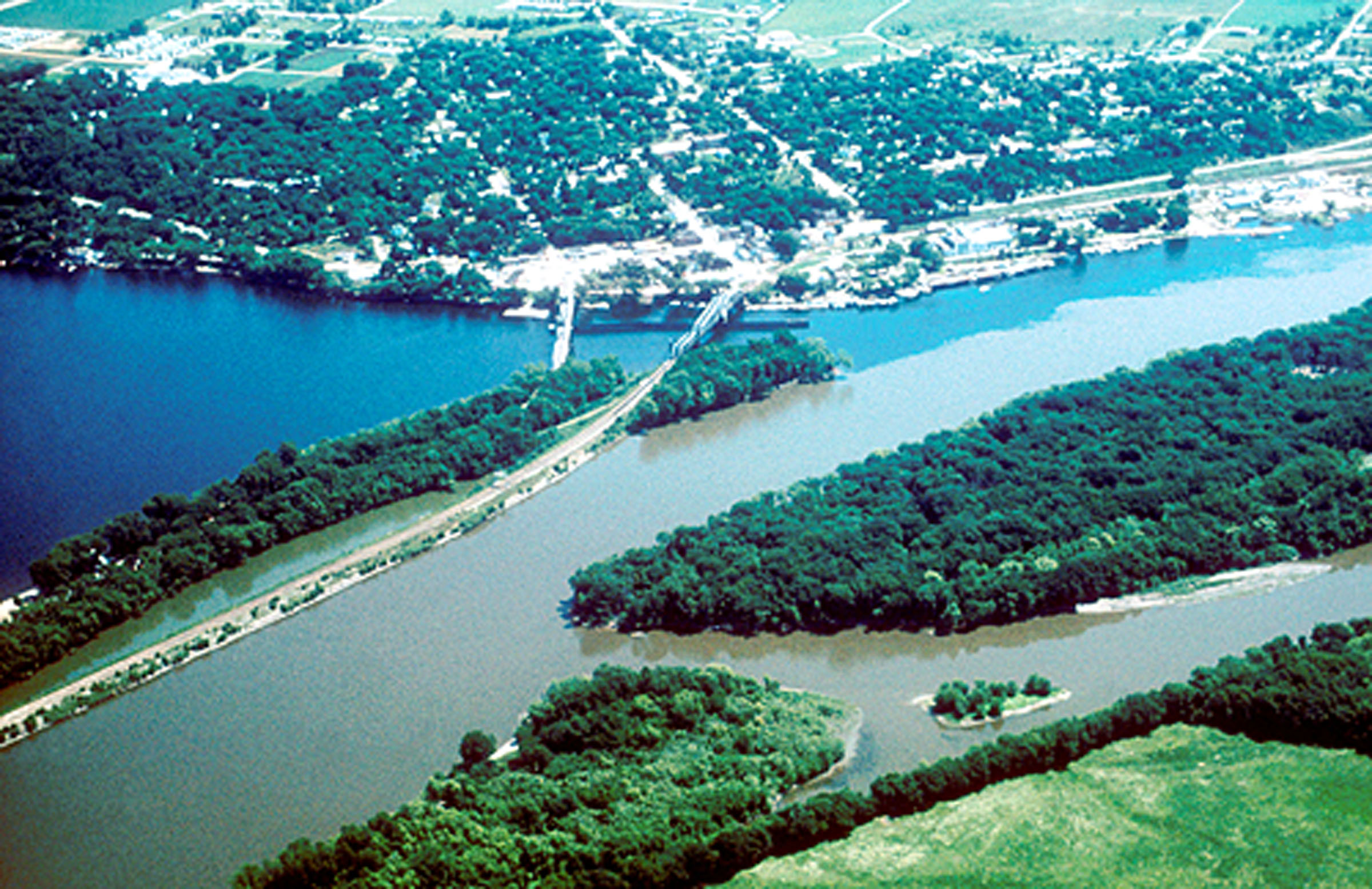
| | | | The first map shows the lower St Croix, and how the thin black line of 95 (not named) reaches the Mississippi with no town on the MN side (Hastings MN is across the Mississippi). But on the Wisconsin side is Prescott, so we cross over (second map) and drive a bit along Lake Street (the river is wide here), then along Jefferson Street, and here our serendipity works out well. Just where Monroe Street bends is the entrance to the Freedom Park Overlook on the Mississippi bluffs, as well as the Great River Road Visitor Center. | | | | Use this aerial view of the confluence as a guide (no attribution). The lower right is the Hastings side of the Mississippi. We've just been riding along Point Douglas, a bit of MN that almost blocks the St Croix's mouth. Note the difference in color of the two rivers, and how they stay separated for a while. This is just the area the American Queen passed at night before our arrival in St Paul. Beyond is Prescott, and the Overlook is probably just off this picture to the right.
http://3.bp.blogspot.com/-qFtDlJFBElE/VEUaaOCqJ-I/AAAAAAAABOQ/KjbwYrk_avM/s1600/IMG_4033.JPG
http://www.freedomparkwi.org/Resources/image5.png
https://s-media-cache-ak0.pinimg.com/736x/cd/77/a9/cd77a9c4353fe3d09ffc7083f8baa0c9.jpg
| | | | The first view is of the Great River Road Visitors Center at the Freedom Park Overlook, on bluffs about 122 m (400 ft) high. The other two are views from the bluffs, our last views of the Mississippi on this entire trip.
http://www.minnesotamonthly.com/Guides-Resources/Maps/Where-Twin-Cities-Maps/2012-Where-Map-Metropolitan-Area.jpg
| | | | We've used this map before, when we first left St Paul upstream. Now, rather than staying on the east bank, we cross over to Hastings and continue up along the west bank of the Mississippi, just along where the AQ went at night. This way we enter St Paul from the part of town across the river from downtown, just to see skyline views from here. We re-enter town on the Wabasha Street Bridge, and you'll remember this map:
http://moon.com/wp-content/uploads/2014/08/01_04_DT-St-Paul.jpg
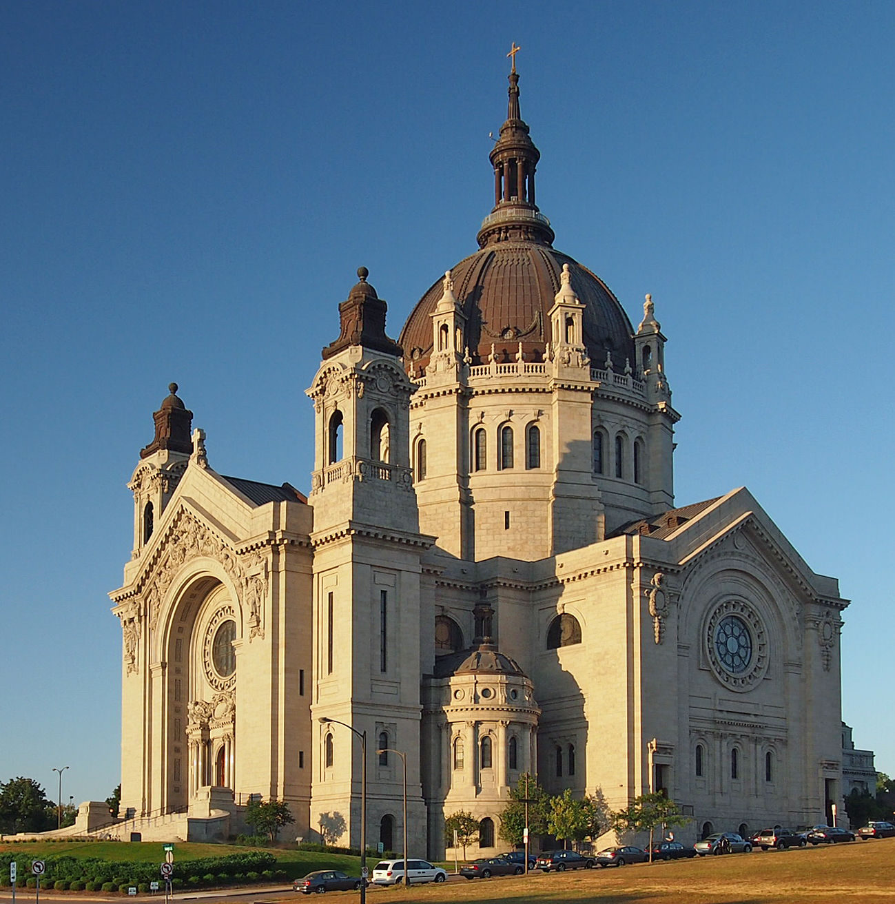
| | | | A bit of zig-zagging gets us up to our catch-up destination from last Sunday, Summit Avenue, with the Cathedral of St Paul (click) in a prominent location (Photo by McGhiever). Its style, featuring a distinctive copper-clad dome, and location overlooking downtown St Paul make it very distinctive. It's the third-largest completed church in the US and the fourth tallest. The current building, which opened in 1915, is the fourth cathedral in St Paul to bear this name. Its open design (click) (Photo by MPHaas) allows for extensive, unobstructed views. The dome (Photo by Nheyob) is 23 m (76 ft) in diameter and 57 m (186 ft) high.
https://www.ramseyhill.org/resources/HomeSlideShow/Cathedral%20Hill.jpg
| | | | The most notable part of Summit Avenue begins at the Cathedral, and in the very next block and across the street—should you doubt its proximity, the above evening picture will prove it--is the James J Hill House, the mansion of the magnate of the Great Northern Railroad. The Hill House (Photo by Teemu008), completed in 1891, was very large and the "showcase of St Paul" until his death in 1916. It covers 3,344 m2 (36,000 ft2 ad includes 42 rooms, 22 fireplaces, and 13 bathrooms. We toured it once years ago, and it's formidable. It is, as you may now be able to recognize, in the massive, rugged Richardson Romanesque style with the huge rounded arches, randomly sized red sandstone blocks of stone, and sturdy pillars. | | | | | | I've just now read that there is interest in building a St Paul Funicular from Summit Avenue just west of the Hill house (see map) down and across I-35E, Thompson and Smith to 7th Street (a major thoroughfare) at Walnut. Shades of Dubuque a century and a third later! |
| | | | One of the best-preserved Victorian residential boulevards in the US is Summit Avenue, which runs for 7 km (4.5 mi) from downtown to the Mississippi. It's lined with over 300 mansions for the late 19C elite, and remains a tony address. Other cities may have similar streets, but well-preserved Summit Avenue is notable for having preserved its historic character and mix of buildings, which can't be said for some of the others. It's part of two National Historic Districts and two St Paul Heritage Preservation Districts. | | | | Mansions started to appear on the hill in the early 1850s as St Paul grew. The oldest remaining house dates from at least 1859. Growth was strong in the 1880s as city water service arrived in 1884, a cable car appeared on nearby Selby Avenue (see map) in 1887, and in 1890, early streetcars began operating on nearby Grand Avenue, and with improved access to downtown, the area became a fashionable place to live. | | | | | | There was a decline during the Depression in the 1930s as many old mansions became rooming houses, or stood vacant for many years. But the height of the bluffs prevented downtown from expanding, preserving much housing stock. The area began to turn around again in the 1960s and 1970s as young couples could afford to buy Victorians and restore them, and today the area is fashionable again. |
| | | | But we actually haven't finished talking about the formidable James J Hill. He and his family had been living in Lowertown St Paul, but it began to become commercialized and Hill's possessions began to overflow his house, he decided to move uphill. Between 1882 and 1886, 46 new houses had been built on Summit Avenue. In case you think that teardowns are a new idea, Hill bought three lots and tore down the first house that had been built on Summit, in order to replace it with his mansion, both because of the proximity to the Cathedral and the commanding view of the city and Mississippi. He wanted his new house and its location to add to his status as the "Empire Builder".
http://www.placeography.org/images/3/32/Summitavenue.gif
| | | | This small map shows just the east section of Summit Avenue. The Hill house is not named, but is on the south side, halfway between Selby Avenue and Nina Street. We now drive down Summit admiring the mansions along the boulevard and the autumn colors of its trees. There's one building in particular we're looking for, and we find it on the north side, beyond Kent Street near Dale Street. It's the F Scott Fitzgerald house, where the author lived in a third-floor apartment. The Fitzgerald House (Photo by McGhiever) is also known as Summit Terrace, and it's part of several row houses. Because of that design, it was called the "New York Style", and like the Hill House, is also has the flavor of the Richardson Romanesque style. It's a brownstone two bays wide; the bay on the right is a multi-sided window bay two stories high, while the bay on the left includes the entrance, recessed under a round arch that itself is flush with the front. Above there's a gable with two windows, also with rounded arches.
| | | | Fitzgerald's parents moved here while he was studying at Princeton. In 1919, he rewrote here the manuscript that became his first novel. He lived here writing short stories, then moved to New Orleans. This house is closely associated with his fame, and his works reflecting the Jazz Age. His full name was Francis Scott Key Fitzgerald, and was named after his (very distant) famous second cousin, three times removed on his fathers side, Francis Scott Key, who wrote the words to the Star-Spangled Banner. He apparently rarely used his full name, and called himself F Scott Fitzgerald. Less formally still, he was Scott Fitzgerald. | | | | It was time to return the car to Enterprise and get a ride to the hotel, the same one we stayed in just over a week ago. Since we rented and returned at the same dealership, and had a few extra Enterprise points, we had been able to plan to get one free day on points on the rental. I spent the rest of the afternoon writing online. | | | | Beverly's cousin Steve had been a groomsman at our wedding in 1962, and I've kept close to him and Lynette over the years, and Lynette is even on my website mailing list. While most of the family lived in Minneapolis, it was always a bit quirky that Steve & Lynette lived in St Paul, where I once visited them at home a half-century earlier. This time, I'd gotten in touch with them in advance, and they invited me to dinner at their house, so Steve came to pick me up. It was a pleasant evening of reminiscing, but the thing that struck me most was their story of ethnic change. We're aware that the large majority of earlier Minnesotans emigrated from Scandinavia and Germany, and for a very long time kept up their ethnic rituals. But in recent decades, particularly after the Viet Nam war, immigration from Asia, as well as Africa and Latin America has expanded considerably to Minnesota. It was particularly interesting to hear how a new type of ethnic food and celebrations had been taking place at their church, while the Scandinavian customs were in decline. | | | | Day 29: The Empire Builder: Saint Paul to Chicago The next morning, the Empire Builder was due in from the West Coast and scheduled to leave St Paul at 8 AM en route to Chicago. While we know that the freight railroads slow Amtrak down, especially this far from the origin of the train, but we really had to be there on time. After an early breakfast, it was only a four-block walk down 4th Street to the St Paul Depot, although the October darkness at that time was not exactly a plus. | | | | Sure enough, the train was posted as being delayed, which eventually extended to two hours, but it was finally in. In the past, I'd ridden coach on this segment, and wasn't enthusiastic about it, so I'd booked a day rate on a roomette, which was cheaper than the overnight rate. Apparently, so had one other person, so we were allowed to take the elevator down to the track first. This is the Empire Builder at St Paul Depot, showing the brown brick station reaching out to above these outer tracks. As an example of how much is available on the internet, you'll recall that we just saw an internet picture of the St Croix Crossing near Stillwater that was taken just 13 days before I was there. Same thing here. This picture of an 11-car Empire Builder was taken on 27 September 2015. I took this train from the very same spot on 13 October 2015, just 16 days later.
http://www.dot.state.mn.us/passengerrail/images/empirebuildermap.jpg
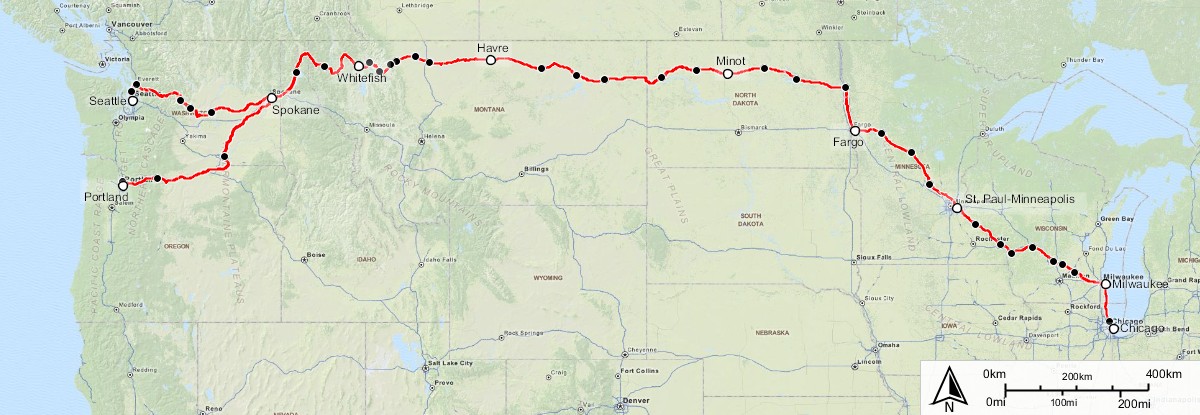
| | | | Above is the route of the Empire Builder within Minnesota, which we used in 2016/6 when discussing the Northstar Line. Our first stop was in Red Wing, where it was fun to be at the station we'd only recently visited on our AQ stop. We rode along Lake Pepin, that wide part of the Mississippi, and crossed over to La Crosse WI, where we'd also stopped on the AQ. To continue, this s the complete route of the Empire Builder (Map by Jkan997) as we crossed Wisconsin on the way to Chicago. This train is Amtrak's busiest long-distance route, carrying over a half-million passengers a year. | | | | It was easy to remember the first time I went from The Cities to Chicago on this train (in coach!), except then it was still part of Hill's Great Northern. It was after the wedding trip in 1962, and Beverly was moving east. Flying was out of the question, mostly because we had to transport so many wedding and shower gifts, and having a lot of checked baggage was far easier by rail, which would be transferred automatically in Chicago. As it was, we'd still be taking wedding and shower gifts to New York in our bags over visits for years to come. I remember Beverly's mother tearfully seeing us off at the now gone Great Northern Station in Minneapolis. The train crossed the Stone Arch Bridge, and I definitely remember it stopping in St Paul, since at the time, I hadn't ever been to St Paul. | | | | Along with everything else, it was hectic at the time in Chicago because of a necessary transfer by taxi. We've discussed how big cities like Paris, London, and St Petersburg have multiple rail stations, based on the different private railroads which each built its own station. While now, transfer in Chicago is easy, because Amtrak uses only Union Station, it was not so easy in 1962. I wasn't sure about the details, so I checked with railfan friend Dave, who, in addition, works for Amtrak, as to Chicago stations in the day. He assured me that the Empire Builder did use Union Station then, although its route getting there was different. But at the time, the Lake Shore Limited (yes, this current trip is a duplicate of the wedding trip) run by the New York Central, departed from LaSalle Street Station in Chicago until 1968.
http://images.travelpod.com/cache/accom_maps/JW-Marriott-Chicago.gif
| | | | Today LaSalle street just serves commuter rail, but at the time we needed a taxi. On this map, find Union Station center left on Adams Street, west of the Chicago River. Then find the LaSalle Street Station at the bottom center. Google maps says a drive would be 5-6 minutes, and even a walk would be 12, but it's a bother when you're changing trains, and trying to catch the second one. But we did it. | | | | | | I once saw a documentary about Chicago that had a great segment. I've tried to find it on YouTube, but it isn't there, so you'll have to picture it. The heyday of Hollywood in the '20s, '30s, and '40s was the heyday of rail travel, and celebrities going between the coasts would be among those that had to do the taxi schlep in Chicago between trains. A local Chicagoan developed the hobby of shooting films of the celebrities he could spot as they climbed in and out of taxis. I remember a picture of Clark Gable smiling and waving at the camera, and others. But in particular I enjoyed seeing Laurel and Hardy. Stan gave his goofy grin to the camera and did his iconic head scratch, ad Ollie beamed and twiddled his tie to the camera on the way to the taxi. Marvelous. |
| | | | Day 30: The Lake Shore Limited: Chicago to New York But now the transfer is all within Union Station, and is so easy when you're a sleeping car passenger and have the Metropolitan Lounge to wait in. This is the Lake Shore Limited (click) leaving Chicago's Union Station, with the Willis Tower (ex-Sears Tower) in the background, and this is its overnight route to New York (Map by Mackensen), with a section going to Boston. I particularly remember after the train split in Albany and we were going down the Hudson valley how my window's view was not to the river, but inland, and how at one point I got a beautiful final view (after the views in Minnesota) of trees with fall color with the setting sun giving a golden aura to the scene. | | | | Freebies There was a time when I knew little about getting travel free on some sort of points or another. I really got started with Starwood Hotels and their Starpoints, and have gotten nice hotel accommodations in a number of places. I also remember how I was able to fly to Japan, then back from Taiwan, free on air miles. But on this trip, there were all of a sudden a nice string of freebies, which I want to summarize now. I'm really quite pleased that I've learned to play the game. The following were free on points on this trip: | | | | | | The flight on United, New York to Memphis on Mileage Plus points.
One night at the Westin Kansas City on Starpoints.
The Missouri River Runner, business class, from KC to St Louis, on Amtrak Guest Rewards.
The one day (half-day) car rental in Dubuque to go to Galena, on Enterprise Points.
One free day of the Minnesota car rental on Enterprise Points.
|
| | | |
| |
|
|
|

