|
Reflections 2016
Series 8
May 7
Enclaves & Exclaves
| | We left the narrative in Bemidji, having just returned from Lake Itasca. When planning the trip, there were two options at this point. On was to drive back down to St Paul directly to go back to New York. The other was to go see the Northwest Angle. I had heard of it on my first trip to MN, the wedding trip in 1962, from family who were catching me up on Minnesota. I remember they talked about Minnehaha Falls, Lake Itasca, and the Northwest Angle, in an attempt to get an Easterner interested in the state. It worked, and I didn't realize how little I really knew at the time about MN. Well, I've picnicked and visited Minnehaha Falls numerous times, have now returned to Lake Itasca a second time, so one place in that grouping is left on my bucket list. It'll be a two-night side trip out of Bemidji, the second side trip after Kansas City out of St Louis, and will be described in the posting after this one. | | | | But first we have to know what it's all about. We often talk about the physical map, discussing rivers, tectonic plates, islands, ice caps, and more. Sometimes we go to the political map, where humans draw lines between themselves and other humans, as when we discussed the growth of the US, of Canada, and of Australia. But I've now had a lot of fun on the political map collecting new general information on enclaves and exclaves, more than we've reported on piecemeal in the past, and I think these results are both more comprehensive and more accurate. Let's discuss the leading ones of these to see how the Northwest Angle fits in. | | | | Enclaves & Exclaves The list of enclave-and-exclave-type territories is amazingly large. Just think of all the tiny nameless bits and pieces of US states on the "wrong" side of the Mississippi alone. Wikipedia has a very long list of thousands of flyspeck properties like this around the world, and we won't have anything to do with that. The places we mention will be a select list of the most interesting ones, mostly on the national level (between countries), to some extent on the subnational level (between states or provinces, even cities), although the subnational ones can go on down the line to counties, school districts, and anything else that has man-made borders. | | | | We'll ▲ first discuss the general topic, with prime examples; ▲ second, we'll discuss three special situations that are particularly unusual; ▲ third, we'll discuss the anomalies specific to the US/Canadian border, ending with Minnesota's Northwest Angle, which we'll finally visit together in the next posting. | | | | I: (True) Enclaves & Exclaves These are the definitions and explanations I've put together. The examples that follow will make them clearer.
ENCLAVE: A TERRITORY ENTIRELY WITHIN ANOTHER ONE, WITH ONE SINGLE SURROUNDING LAND BORDER
EXCLAVE: A SEPARATED PORTION OF A PARENT ENTITY; (1) IF IT HAS TWO OR MORE SURROUNDING LAND BORDERS, IT'S A FREESTANDING EXCLAVE; (2) IF IT HAS ONE SINGLE SURROUNDING LAND BORDER, IT'S SIMULTANEOUSLY AN ENCLAVE
| | | | Don't confuse a landlocked country with an exclave. Picture an independent territory with just land borders (no coastlines). If that territory has two or more land borders, it's a landlocked country, like Switzerland. But if that territory, even if independent, has only one land border, the only possibility is that it's located within a foreign territory, that is, as an enclave. | | | | But what if that territory is a parent with offspring in the form of one or more satellites, still without coastlines. If that satellite has two or more land borders, it's a freestanding exclave of that parent. But if that satellite has only one land border, again the only possibility is that it's an exclave enclaved within a foreign territory. This kind of satellite has a nature that is simultaneously exclave/enclave. | | | | "Enclave" describes the relationship between a territory and a single surrounding territory. "Exclave" describes the relationship between a satellite and a parent territory, be that satellite freestanding or enclaved. | | | | The list of places on a ▲▲▲ national level, is an easy one to make, because there are in the world only three nations that are ●● enclaves, and since they are independent, they are NOT also exclaves: Lesotho, San Marino, Vatican City. | | | | This is Lesotho (Map by Htonl), totally enclaved in South Africa (don't be confused by the provincial borders of SA). You see Lesotho's one, single, surrounding land border. But your eye is sure to wander to nearby Swaziland, which on the map looks like a twin. But it has two land borders, with South Africa and Mozambique. This makes it just a landlocked country, like nearby Botswana, or Switzerland or Hungary.
http://www.maps-of-europe.net/maps/maps-of-san-marino/san-marino-on-map-of-italy.jpg
http://stanfords.s3.amazonaws.com/coverage/182250_vaticanWM_gizi_cov.jpg
| | | | While I've been to South Africa, I've never been to Lesotho. On the other hand, I've been to the other two, which are both enclaves in Italy. San Marino is in the northern third of Italy, and I've driven up into the mountains from Rimini on the Adriatic. You will now be tempted to think of Andorra and Liechtenstein, but they are again landlocked countries, Andorra bordering on both Spain and France, and Liechtenstein on Austria and Switzerland (with which it however has a customs union.) Vatican City is an enclave in Italy on the national level, and in Rome on the subnational level. In this case, your mind moves to the UN. Just as foreign embassies enjoy extraterritoriality, but with the host country sovereign, that is also the case with United Nations Headquarters in New York, the UN Office in Geneva, Interpol HQ in Lyon, NATO HQ in Belgium, and others.
http://blog.brillianttrips.com/wp-content/uploads/2011/09/20110928-015205.jpg
| | | | The three entities that follow are simultaneously ●● enclaves & exclaves, and we talked in 2004/13 about visiting the first two. Llívia is an exclave of Spain enclaved in France (see map). When you leave Puigcerdá to the north, you see signs that you're entering France. Then, after 6 km (3.7 mi), signs say you're entering Spain, specifically, Llívia. While today, all Schengen borders are open, at the time of our visit, there were still border checks between Spain and France—but not on this road. We also talked in that posting about visiting Campione d'Italia, an exclave of Italy enclaved in Switzerland. Campione is on Lake Lugano (Map by Tschubby)--not named here. Place names are in German on this map, and the borders here are wild. In Campione, legal tender is the Swiss Franc, though the euro is widely accepted, but then that's the case everywhere in Switzerland, surrounded by Euroland. Campione is within the Swiss customs union; license plates and phones are Swiss; Italians here benefit from the Swiss health system; mail may be sent using either a Swiss or Italian postal code; security is provided by Italian Caribinieri (military police). Since writing the first piece, I think I've figured something out, and have added this to that posting: Campione d’Italia seems to mean "Champion of Italy", which doesn't seem to make sense, but further research shows that campione can also mean "piece", and a separated Piece of Italy it is.
| | | | For the third one in this group, we have to go from southern to northern Switzerland to find Büsingen, an exclave of Germany enclaved in Switzerland, on the Rhine, specifically on a section of the Rhine known as the Hochrhein / High Rhine. Büsingen (Map by Warhog) is surrounded on three sides by the Swiss Canton of Schaffhausen, which separates Büsingen from the rest of Germany by a strip of land 700 m (2200 ft) at its narrowest. As with other exclaves, Büsingen is simultaneously an exclave of the Bundesland of Baden-Württemberg and other subnational entities. But it's part of the Swiss customs union and usually uses the Swiss franc. There are strict regulations as to how Swiss and/or German police can make arrests. Children attend local school up to fourth grade, after which parents can choose either a Swiss or German school. Either Swiss or German postal codes apply, either stamps are valid, either phone system can be used. Büsingen has its own German license plate designation starting with BÜS. These plates allow vehicles to be treated as Swiss. But there are very few BÜS plates, and it's the rarest license plate designation in Germany. | | | | | | While Büsingen is the international exclave to note on the High Rhine, there's a subnational one here we can slip in. Look at this map of the Swiss Canton of Schaffhausen (Map by Tschubby) surrounding Büsingen, which has its own two exclaves, one to the south, which borders both other parts of Switzerland and Germany to its north, and the eastern one, an enclave in Germany. (We'll come back here down below to discuss Swiss Stein am Rhein at this point and German Konstanz upriver.) |
| | | | A ●● freestanding exclave is represented by Nachchivan, an exclave of Azerbaijan. Nachchivan (Map by Kheo17) is separated from the country's principal area by Armenia, which it borders along with Iran, and to a tiny extent in the NW, Turkey. Again, having two or more borders disqualifies it from being an enclave. I've never been to the Caucasus. | | | | On a ▲▲▲ subnational level, there is a number of enclaves and exclaves on the provincial level in France, Italy, India, and far beyond. There is also a great number of capital cities around the world that exist as ●● enclaves within a local province or state. I understand that this applies to Vienna, Brussels, Prague, Berlin, Budapest, Bucharest, Kiev, Addis Ababa, Phnom Penh, Kuala Lumpur, Taipei. | | | | | | This also applies to the Australian Capital Territory (ACT), the location of Canberra, as discussed in 2010/12. We'll say a bit more again when we discuss the associated Jervis Bay Territory below.
If you are looking to see in this list the District of Columbia in the US, home of Washington, it is not an enclave, but simply a landlocked entity, since it has two borders, with Maryland and with Virginia.
|
| | | | In the US, this is a sampling of urban enclaves:
https://detroitography.files.wordpress.com/2013/08/1102494_10151786578616575_1840816300_o.jpg
http://u.realgeeks.media/davidsellsdenver/denver-metro-map.jpg
http://www.caltenantlaw.com/LAparts_files/LA.jpg
| | | | First map: in Michigan, Hamtramck and Highland Park adjoin one another, and the pair together form an enclave in Detroit.
Second map: in Colorado, Denver has two separate enclaved cities, Glendale is the white blank further north, and Holly Hills is further south.
Third map (click): in California, Beverly Hills (to the west) and West Hollywood (to the east) adjoin one another, and the pair together form an enclave in Los Angeles. To the north, San Fernando forms its own enclave. Santa Monica, because of its coastline, is referred to as a semi-enclave, and belongs in category II below.
| | | | Earlier in this trip (2015/18), we visited a major subnational ●● freestanding exclave, the Kentucky Bend (Map by Jim Efaw). | | | | II: Semi-Enclaves & Semi-Exclaves Santa Monica above was the perfect example to introduce this second category. Water makes the difference. If you see a coastline on any level of enclave or exclave, national or subnational, its status moves down a notch and it becomes a semi-enclave or semi-exclave.
SEMI-ENCLAVE 1: AN ENCLAVE (ONE SINGLE LAND BORDER) WITH A COASTLINE
SEMI-EXCLAVE2: AN EXCLAVE WITH A COASTLINE; (1) IF WITH TWO OR MORE LAND BORDERS, IT'S A FREESTANDING SEMI-EXCLAVE; (2) IF WITH ONE LAND BORDER, IT'S SIMULTANEOUSLY A SEMI-ENCLAVE
| | | | | | 1THE COASTLINE MUST BE SHORTER THAN THE LAND BORDER. THIS PROVISO IS TO AVOID INCLUDING PORTUGAL, DENMARK AND CANADA, WHICH EACH HAVE ONLY ONE LAND BORDER, BUT A LONGER COASTLINE
1WATERS SEPARATING THE PARENT COUNTRY AND FREESTANDING SEMI-EXCLAVE MUST BE INTERNATIONAL OR FOREIGN, NOT DOMESTIC. DOMESTIC WATERS TIE TOGETHER TWO ENTITIES RATHER THAN SEPARATE THEM
|
| | | | On a ▲▲▲ national level, again this first one is an easy list to make, because there are in the world only three nations that are ●● semi-enclaves, and since they are independent, they are NOT also semi-exclaves: Monaco, Gambia, Brunei. | | | | This is Monaco. It has one single land border, with France, but it can also be easily reached by water, avoiding France, as many wealthy people do with their yachts. This classifies Monaco as a semi-enclave.
In West Africa, Gambia, also known as The Gambia, consists of the north and south riverbanks of the Gambia River, and is surrounded on three sides by Senegal. Its short coastline makes it a semi-enclave. Alex Haley's TV series Roots was set in Gambia.
In the East Indies, on the island of Borneo, is Brunei (Map by Ranking Update), which rhymes with "sky". As the map shows, roughly the southern two-thirds of Borneo is part of Indonesia, and most of the northern third is part of Malaysia. Brunei, in green, is the only sovereign state completely on Borneo. I now see that Brunei comes in two parts. Each part has a coastline, so we're in the right category. It seems that the eastern part consists of one district, while the western part consists of three districts and includes the capital, so that would apparently be the principal part. But both parts are connected by domestic territorial waters. For that reason, the two parts do count as one single semi-enclave in Malaysia. At the very most, the eastern part, because it's not easily accessible, can be considered a functional exclave of the main part, described below, but still part of it.
| | | | The entities that follow are simultaneously ●● semi-enclaves & semi-exclaves, and the first one is going to knock your socks off because of its large size. Alaska, because of its one land border and coastline, is a semi-enclave of Canada and a semi-exclave of the US. It is also by far the largest semi-enclave/semi-exclave in the world. This map shows the Economic Exclusion Zone of the US, which I believe is exactly the same as its territorial waters. The only way to reach Alaska by land from the continental US is via Canada, and the only way by sea is via either Canadian waters or international waters, since the domestic territorial waters don't adjoin. | | | | Spain has two so-called autonomous cities on the Moroccan coast, Ceuta & Melilla. As autonomous cities, they are considered an integral part of Spain, as shown on this map (Map by Anarkangel). and are therefore each simultaneously semi-exclaves of Spain and semi-enclaves in Morocco. I have taken the ferry ride from mainland Spain to Ceuta as a day trip, but have not been to Melilla. Note the tiny purple marks on the map indicating international borders. You expect them for these two places, and also for Gibraltar. But also note the several ones on the Moroccan coast, better illustrated here (Map by Aotearoa). These are several tiny Spanish islands in Moroccan waters, and two rocky crags (peñones along the coast. We mention these just to say that there are thousands of flyspeck territorial claims around the world like this, and that we are just discussing here the most significant. | | | | Still on a national level, we have some ●● semi-exclaves of interest. After WWII, Russia took over the northern half of the former East Prussia, including the city of Königsberg, renamed the city Kaliningrad, and called the territory the Kaliningrad Oblast (Region). When looking now at the map of Russia, or the Russian Federation, click to find in the west the Kaliningrad Oblast, which is a freestanding semi-exclave of Russia, with two different borders, with both Lithuania (#3) and Poland. | | | | Again on the west coast of Africa, we come across Cabinda. This map shows Angola in pink (Map by Azylber) with its freestanding semi-exclave of Cabinda in red. Cabinda borders both the Republic of the Congo in green and the Democratic Republic of the Congo in blue. The territorial water of the latter separate Cabinda from the rest of Angola. Now on this map look up the coast at a small gray rectangle, with an island to its northwest. This is Equatorial Guinea, which we'll discuss below. | | | | In South America, French Guiana is considered an overseas department and region of France, as this map shows (Map by TUBS). That makes it a freestanding (two borders) semi-exclave of France in South America, where it borders Suriname and Brazil. | | | | On a ▲▲▲ subnational level, we'll just mention again the city of Santa Monica being a semi-enclave in Los Angeles (see above). But we also have to include Gibraltar here, since, unlike Ceuta & Melilla and Spain, it isn't an integral part of the UK, but rather an overseas territory of it. It's a semi-exclave of the UK and a semi-enclave in Spain. As we saw on the earlier map, Gibraltar (Map by Eric Gaba) is on Spain's south coast. As English calls the formation the Rock of Gibraltar, Spanish calls it El Peñón de Gibraltar, so now you can imagine what those two claims of peñones on the Moroccan coast must be like. | | | | I have the perfect example illustrating land and sea borders in a semi-enclave/semi-exclave. The first time we went to Gibraltar, political relations between Spain and the UK were very tense about Gibraltar, and the land border between Spain and Gibraltar was closed to all traffic. We were in the Spanish city of Algeciras (Map by Dr. Blofeld, based on work by Miguillen), right on the west side of the Bay of Gibraltar (note here how close Ceuta is), and we were advised to simply take the ferry across the bay, so we were pedestrians in Gibraltar on our first visit (which, as with all novices, we never considered we'd ever repeat!). The point is, the land border isn't all-important in a semi-enclave—you can get there by water! | | | | Many years later, when we were driving through Spain again, the Gibraltar border was open, and we drove in and around Gibraltar. Do realize that there's a regular traffic light where the road crosses the runway, just in case a plane is landing or taking off. Weird! "The Rock" faces north, inland, in its iconic view, which many people don't realize, and then slopes to the south, so the view on entering via the land border is spectacular. It was on this second visit to the area that we went to Ceuta. | | | | III: Functional Enclaves & Functional Exclaves The third and final type is another step downward, almost to the point of falling off the ladder—are these places REALLY enclaves and exclaves? Just as the catchword "WATER" made the difference moving down from enclaves/exclaves to semi-enclaves/semi-exclaves, we also have a catchword in this next step down, "ACCESS". Look at it this way. If your hand itches, it's accessible, and you can scratch it. If your back itches, even though it's still a part of YOU, it's far less accessible and you have to resort to other means to reach the problem. | | | | It might seem a bit weird, but if you can't easily access a part of the parent territory, either by land or by (domestic) water, even though that part is attached to the rest, functionally it's "foreign" and is considered a functional enclave or functional exclave. | | | | I have a perfect personal example. When we built our house in Purchase NY we had an acre of land on the north side of Beverly Road (yes, Beverly). The house was to the east, because a narrow branch of Blind Brook, maybe 2 meters/yards wide, ran down the western edge. The entire brook was within our acre, since the western property line ran along the slope from the brook up to the neighbor's driveway. Beverly Road crossed the brook on a handsome stone bridge, facing our house. We rarely had to access that slope, maybe on occasion to do some weeding, but when we did, we weren't about to wade through the water. Instead we went down our driveway to the public road, turned right across the bridge, turned right into the neighbor's driveway, and walked down his one meter/yard of the riverbank to our one meter/yard on the water. | | | | Now that west bank was absolutely a part of our acre, across the stream, but it wasn't easily accessible, other than across public property and the neighbor's property. Being attached, was it an enclave or exclave? Technically, no, but for practical purposes, yes. That bank would be considered a functional (or practical) exclave of our acre and a functional (or practical) enclave in the neighbor's property. | | | | | | But if easy access is added, the status might change. If we had put a log bridge across Blind Brook like the one where I crossed the Mississippi at Lake Itasca, we could have reached the other side while still staying on our own property. According to some opinions, a bridge would have negated the area being a functional exclave/enclave. Personally, I consider the accessibility of the situation as nature presented it, and don't count a man-made bridge as negating anything. Form your own opinion. |
| | | | So now let's move this image up to an international level for our definition:
FUNCTIONAL (PRACTICAL) ENCLAVE/EXCLAVE: A PART OF THE PARENT TERRITORY ACCESSIBLE BY LAND ONLY VIA AN EXTERNAL TERRITORY, OR VIA DOMESTIC WATERS
| | | | It's somewhat amusing to try to decide whether such a territory is a functional exclave of the parent or a functional enclave within the parent, since you have to leave the parent to access it, then come back to a remote section of the very same parent. I suppose they're both. | | | | On a ▲▲▲ national level, we have to start with the "poster child" for this sort of situation, since it's always cited as the prime example, the Kleinwalsertal in Austria. We'll explain the name shortly. It's usually cited as a functional exclave of Austria, which it is, but I see it more urgently as subnational first, a functional exclave of the Bundesland (state) of Vorarlberg, and then subsequently rising up to the national level. | | | | Let's see what we're talking about, using this map of Austria (Map by Golbez). First note what we mentioned earlier, that Vienna is an enclave in Lower Austria. Also, we should point out, that Tyrol comes in two parts, the larger being North Tyrol, and East Tyrol being a (subnational) exclave of it. But our point here is to show that Vorarlberg is by far the westernmost Bundesland, attached to the rest of Austria only via Tyrol.
http://www.landblick.com/_hintergrund/vorarlbergkarte.jpg
| | | | Look at the map and see how Vorarlberg is so far west that it hugs Liechtenstein and Switzerland (Schweiz). To its north is Germany (Deutschland). Now let's play "find the functional exclave". The area is mountainous—after all, it's in the Alps. The darkest brown is the very highest mountains, but pay attention to the lighter brown area. Looking at the valleys, where does the water flow? | | | | While the Rhine in northern Switzerland/southern Germany around Büsingen, Stein am Rhein, and Konstanz, is called the Hochrhein (High Rhine), once your so far upstream that you're this side of the Bodensee (Lake Constance), it's called the Alpenrhein (Alpine Rhine), and that's where we see Vorarlberg water flowing. So where's the anomaly? | | | | Look at the upper right and you'll find a valley, or Tal (think "dale") surrounded by very high mountains, that "does its own thing". The stream there has carved its way to the northeast instead, to work its way up into Germany and to the Danube. The Tal you have found is the Kleinwalsertal.
https://www.vorarlberg.at/jpg/trinkwasserversorgung2012.jpg
| | | | That map showed waterflow, this one shows roads, and the situation is not any simpler. Unless you're a mountain climber, you can't reach the Kleinwalsertal from the rest of Vorarlberg. Nor does it help to go next door to Tyrol, as that first map also shows. You have to leave Austria and go to Germany, then come back into Austria's Kleinwalsertal to access it. That's the textbook definition of a functional exclave. | | | | In southwestern Switzerland is the canton known in French as the Valais, a name used also in English. It's where Zermatt and the Matterhorn are located. The name in German, though, is Wallis, and the people from there are the Walser (VOL.zer). If you really require an English word, I supposed it could be "Valaisians". In 1270, a number of these Walser emigrated across Switzerland to settle in what is today the canton of Graubünden/Grisons, in Liechtenstein, and in Vorarlberg. Two valleys here are named after them. Look in the last map and find, right in the center "G. Walsertal", for Grosses Walsertal, the Great Walser Valley. But the valley we're talking about, which also can be rendered as the Kleines Walsertal, is the Small Walser Valley. The Walser dialect of German to this day remains distinctive from others around it.
http://www.gasthof-bergblick.at/images/anreise/anreise.jpg
https://skimap.org/data/981/1/1289535629jpg_render.jpg
| | | | These two maps show Austria's functional exclave from the German side. You have to make your way from Tyrol to the Bavarian town of Oberstdorf, and only then can you drive back into Austria on the one road available into the Kleinwalsertal. We did this years ago, but I don't remember what village we stayed at. There are no trains, the closest rail station being in Oberstdorf. The second link is looking SOUTH from Bavaria at this skiing area. The border isn't shown, but click to find Oberstdorf in the lower left, then on the right, follow the Breitach River and the road up the valley to Riezlern, Hirschegg, Mittelberg, and Baad at the end of the road. This last map shows the Kleinwalsertal (Map by Lencer) very clearly from the Austrian point of view, and how the highways in yellow to the south in no way connect to this valley.
| | | | Take note of Mittelberg. You may think that this sort of a functional exclave is a quirk with little real import, but I've found something in German Wikipedia, and not in English. It involves the current refugee crisis. Late last year, as the refugee situation in Austria worsened, Mittelberg was ready to do its part to settle refugees in town. Housing was prepared, as were German language courses. But then bureaucracy reared its head, since there was no legal way to bring refugees in the main part of Austria through German territory to the Kleinwalsertal, and all plans were cancelled. | | | | We now move to the British Isles, where water becomes a factor in the situation of Northern Ireland (Map by Peeperman). It's a functional enclave in [the Republic of] Ireland and a functional exclave of the UK. Its one land border is with Ireland, and can be reached by land only through Ireland. This at first looks a lot like the Alaska "semi-" situation, but in this case, unbroken domestic territorial waters between Northern Ireland and Scotland—I've made that crossing twice by ferry—bind Northern Island to the island of Great Britain as a single unit. Therefore, based on convenience of access, it's only a functional exclave. | | | | We can now get back to Africa and to our above reference to Equatorial Guinea, formerly Spanish Guinea. We see again here its two regions, one insular, one on the mainland. The insular region consists mainly of Bioko (Formerly Fernando Pó), with the capital, Malabo. Though smaller, it has to be considered the primary region, as opposed to the continental region, Rio Muni, bordered by Cameroon and Gabon. Rio Muni appears to be a freestanding semi-enclave, with two borders, but like the previous example, domestic territorial waters between the two parts of the country limit it to being a functional exclave. | | | | On a ▲▲▲ subnational level, we can go back to the High Rhine, where Büsingen was an international exclave and Schaffhausen had two subnational exclaves. Let's look again at that map of the Canton of Schaffhausen (Map by Tschubby) in order to see how the Swiss city of Stein am Rhein is part of the Schaffhausen exclave in Germany, yet part of Switzerland (Photo by Hansueli Krapf), the main part of which is indeed on the south side of the river. In this picture, north is to the left as we look upstream on the Rhine. German Wikipedia gives me some extra details about this situation. North of the Rhine (left) is Stein am Rhein proper, including the Old City (click), school, shopping, the monastery, and castle. The area south of the Rhine is called Stein am Rhein vor der Brugg (standard German: vor der Brücke, or "beyond the bridge"). This is where the rail station and most of the industry is. Residential neighborhoods are on both sides. Since the city is split in two by the river, Stein am Rhein vor der Brugg is a functional exclave of Stein am Rhein (subnational—both sides here are connected to Switzerland), since you can't get there from everywhere, only via the bridge, which even gives its name to the functional exclave. On the other hand, some would consider that that very bridge might negate its being a functional exclave.
Further upstream still on the Rhein is the German city of Konstanz, and this map of the Landkreis (District) of Konstanz (Map by Hagar66) shows the whole stretch of High Rhine we've been discussing. From the left, going upstream, is the Canton of Schaffhausen (unnamed) surrounding the German enclave of Büsingen, the exclave of Schaffhausen (unnamed) containing Stein am Rhein, and finally the German city of Konstanz in red. It, too has a functional exclave on the south bank of the Rhine.
http://www.orangesmile.com/common/img_city_maps/konstanz-map-0.jpg
| | | | Unlike Stein am Rhein, this is on the national level, since this functional exclave of Germany is a functional enclave in Switzerland, with no land border with Germany. On the other hand, access is helped by two road bridges, a rail bridge, and a bicycle bridge between them. Thus we see that functional exclaves can be blatant, like the Kleinwalsertal, and rather iffy, like these bridge situations. | | | | Here we can bring up the Jervis Bay Territory (JBT) (JAR.vis), referenced above in connection with the Australian Capital Territory (ACT). For our discussion of both, see 2010/12. The JBT (Map by Kelisi) was established in 1915 to give the ACT access to the sea. It was established as its own territory, and not a branch of the ACT (Map by Martyman)--this map shows both within New South Wales (NSW). However, there is a relationship in that the laws of the ACT apply to the JBT, which also administers it. Now we said above that the ACT is an enclave within NSW, which can be seen here. The JBT, having a coastline, is a semi-enclave within NSW. Using the strictest legal definition, that's the end of it. But from the de facto point of view, which would consider them connected, the JBT, reachable by land only through NSW, works simultaneously as a functional, freestanding semi-exclave of the ACT! | | | | Within the US, we can cite some large and obvious functional exclaves in Michigan and Virginia, and some smaller, more subtle ones. The Upper Peninsula of Michigan (Map by Phizzy) is a functional exclave of the Lower Peninsula as it can be reached by land only externally, although it is connected by domestic waters (shown). The Mackinac Bridge also connects them. In exactly the same situation is the Eastern Shore of Virginia (click), the peninsula on the southern tip of the Delmarva Peninsula. It, too, has a man-made connection, the Chesapeake Bay Bridge-Tunnel.
https://c1.staticflickr.com/9/8326/8149670838_995e2f8204.jpg
| | | | Smaller is the city of Carter Lake IA on the Missouri River, which we discussed in 2015/5. It can only be reached by land from the rest of Iowa via Omaha NE. The river provides a domestic water connection, but here there is no bridge. And finally, we have two tiny functional exclaves of Delaware in New Jersey, because of the Twelve-Mile Circle. We've discussed the Circle in the past, and will do so even more fully as part of the upcoming trip along the US east coast. But in a nutshell, the Circle dates back to 1681 and had three effects: (1) it traced the distinctive arc denoting the northern border of Delaware with Pennsylvania; (2) it, quite unusually, gave Delaware the entire stretch of the Delaware River falling within the Circle. You'll see that north and south of the circle, the river is evenly divided between DE and NJ. (3) it gave Delaware all three islands in this section of the river. You see Pea Patch Island, but the other two were close to the NJ shoreline, and the channels have since been filled in, making these two ex-islands functional exclaves of DE and functional enclaves in NJ. Only the one at the bottom shows on this map, so let's move to this map of Salem County NJ (Map by Omnedon). Click to see the larger one, now at the end of a promontory on the NJ shore, called Finns Point, and the smaller one further south, which is divided between DE and NJ, with the odd name of Artificial Island, because some of it was formed with reclaimed land.
| | | | Particularly Unusual I've kept three situations for now that are of special interest for being particularly unusual. After these, we'll discuss the anomalies on the US/Canadian border.
| | | | I. Ellis Island, with Liberty Island I see these both in the Hudson from my window looking left. The situation with Liberty Island is unusual, but that of Ellis Island moreso. It all started in colonial days, with the establishment of New Jersey. Its eastern border was defined as reaching the western Hudson shoreline, but not its center, as was the usual practice. Since all the Upper Hudson was exclusively in New York State, this was presumably to do the same with the Lower Hudson, making that river exclusively a New York river. I remember reading somewhere once (I can't find the quote now), that Andrew Hamilton once complained that, when he went fishing off a New Jersey pier, he was fishing in New York waters.
| | | | The border matter was resolved, though, when the two states established a compact, ratified by the US Congress in 1834, that moved the Jersey border from the shoreline to the middle of the Hudson, and further down, to the middle of New York Harbor's Upper Bay.
http://www.ezilon.com/maps/images/usa/new-jersey-county-map.gif
| | | | Click to confirm this on the above map. Of course, as the state line moved, so did the borders of Bergen and Hudson counties get extended, as well as shoreline cities, such as Jersey City. But there was a problem with this solution. There were two small islands off the shore of New Jersey (and Hudson County and Jersey City, etc), and it had been agreed that they would remain part of New York State (and New York City, and New York County [Manhattan], etc). They were Liberty Island (originally, Bedloe's Island) and Ellis Island, which would remain as exclaves of NY enclaved within the waters of NJ.
http://pics4.city-data.com/mapszip/zma1940.png
http://www.buyersadvisors.com/countymaps/hudson_county_map_files/image_map3.gif
| | | | The first map shows Jersey City with the mid-Hudson border. The lower unnamed island is Liberty, the upper Ellis, both here counting as exclaves of Manhattan enclaved in Jersey City waters. The second map shows the borders of Hudson County, and in its waters are enclaved Liberty and (unnamed) Ellis, exclaves of New York County. | | | | This is the situation to this day with Liberty Island, which is why the heading lists this as of secondary interest. But Ellis Island's situation is more complicated and interesting. The Federal Government acquired Liberty Island in 1800, and Ellis Island in 1808, and in 1892, opened the famous immigration station on Ellis. But the island was tiny, and to accommodate the main building, plus hospital outbuildings, began to use landfill to expand Ellis, expansion that continued until 1934. The landfill came from the construction of New York's subway tunnels, plus ballast from arriving ships. The island now has a Museum of Immigration.
http://www.statuelibertytours.com/templates/rt_fresco/images/subway-map.jpg
http://static.comicvine.com/uploads/original/12/125228/4071929-3153875001-Ellis.gif
| | | | The first map shows both islands today. Traditionally, access was only from the New York side, but now there are ferries from New Jersey as well. You'll note how Ellis Island is rather large due to all the landfill, looking like a squared-off C. The second map is more revealing. On the right (north side) is the main building, the rest being outbuildings. But the dark green shows the location and shape of the original Ellis Island, so all the rest is landfill. | | | | Now comes the disagreement between NJ and NY that developed, followed by a lawsuit by NJ that went all the way to the Supreme Court. NY always felt that the extension of NY land was still NY land, and NY appealed to history and sentiment to prove its argument. But NJ argued that landfill and rock dumped in NJ waters, based on the original 1834 compact, remains part of NJ. In 1998, after five years of litigation, the Supreme Court found 6 to 3 in favor of NJ, and the entire landfill part, which is nearly 90% of Ellis Island, but which didn't exist at the time of the compact, became part of NJ. Only the area of the original island, according to that compact, remained part of NY. The problem of the new state line running through some buildings was solved by NY and NY agreeing to share jurisdiction of the island, which nevertheless remains Federal property. Of course, aside from the glory, it does come down to what happens to the sales tax collected from visitors. | | | | So while Liberty Island remains a NY exclave in NJ waters, Ellis island is a bi-state island! The NY exclave in Ellis Island is an enclave actually physically within NJ soil. You can see now why NJ has established its own ferry routes. Look at the ferry routes in that map again and determine how many changes of water and land jurisdiction there are, between NY and the islands as opposed to between NJ and the islands. Yet when I visited Ellis Island (Photo by WPPilot) years ago it was all in NY (click to inspect).
http://matchbin-assets.s3.amazonaws.com/public/sites/383/assets/J95K_02JCredistricting5_2.jpg
| | | | One final view. This is a recent map of Jersey City. It's a rare view showing the two exclaves, Liberty Island's covering the whole island and Ellis Island's covering just the small original area. | | | | | | This little aside about Marble Hill is here, not because it's so very odd, but because it’s the other exclave of Manhattan. But this one is not interstate, or intercity, it's interborough and intercounty. The slender, northernmost tip of Manhattan Island originally had two lobes, one much larger than the other, around which the Harlem River flowed. But in 1895, the Harlem Ship Canal was built to cut off the larger of the lobes, making what was left, called Marble Hill, and island, here in pink, with the rest of Manhattan in gold, and the Bronx in white. In this 1896 map, it's just that, an island. But in 1914 (Map by Iseeaboar) the original part of the Harlem River to the north of that island was filled in, physically connecting this piece of Manhattan to the Bronx. As of that point, Marble Hill became an exclave of the Borough of Manhattan and of New York County enclaved in the Borough of the Bronx and in Bronx County. Since the Bronx is the only part of NYC on the mainland of North America, Marble Hill is the only Manhattan neighborhood also on the mainland of North America. |
| | | | II. United Arab Emirates (UAE) & Oman We are now back on the international level, and it involves my second around-the-world trip in 2010, this time not by rail, but by air, which centered on Australia. But from Perth, I flew back to New York via the UAE (See 2010/24), which was an exhilarating experience in an Arab, Islamic, very modern, yet quite traditional world. I rented a car and drove around all seven Emirates, and even stuck my toe into Oman.
| | | | It's easiest to start with Oman. Click to see the larger main part (Map by TUBS) in white and two exclaves in red. All three parts border the UAE at the upper left (unnamed).
http://www.dailyplebiscite.com/wp-content/uploads/2016/02/madha-nahwa.jpg
| | | | The larger one is a semi-exclave (with a coastline) called the Musandam Governorate on the Musandam peninsula, jutting into the strategic Strait of Hormuz, the narrow entry into the Persian Gulf. With Iran opposite, it controls the strait. Between the two is the small enclave (no coastline) of Madha. It would seem that Madha is an exclave of Oman, and it is, but since it's controlled by, and is considered part of, the Musandam Governate, it's an enclave in the UAE that's really an exclave of Musandam. But there's more to Madha, see below. | | | | The United Arab Emirates (UAE) consists of a crazy quilt of seven emirates (Map by Aotearoa) with multiple enclaves (click). My hotel was in Dubai; the first day I drove to huge Abu Dhabi; the second day I drove a "northern circuit" clockwise out of Dubai to visit the other five emirates. But look at the patchwork on this map. I've just taken time to count enclaves and, not counting areas disputed with Iran, these are the results:
1) Abu Dhabi is a single unit.
2) Umm al-Quwain is a single unit.
3) Dubai has one tiny exclave.
4) Ras al-Khaimah has one large exclave to the south.
5) Ajman has two tiny exclaves, including one under joint control.
6) Fujairah has three exclaves including one under joint control.
7) Sharjah has four exclaves, including one under joint control, and one rather unique one called Nahwa as a counterenclave in Oman's Madha.
http://geosite.jankrogh.com/enklaver/madha/madha_guessed_map.jpg
| | | | And so we finally come to the consummate madness, enclaves within enclaves, or counterenclaves. Nahwa is an exclave of the UAE's Sharjah enclaved within Oman's exclave of Madha, which in turn is enclaved in the UAE, bordering two emirates. On this last satellite map, I came south down the beautiful coastline on the Gulf of Oman, part of the Indian Ocean, turned inland into Madha, then continued to Nahwa. Being in Madha was the only time I've been in Oman. | | | | III. Baarle Calling this entry just Baarle (rhymes with "Carla") is cheating slightly. These are actually twin cities, dizzyingly intertwined. To differentiate which is which, the Dutch city is called Baarle-Nassau and the Belgian city is called Baarle-Hertog, but when looking at a map, it's like looking at two wrestlers during a match, where you can't tell whose arm or whose leg is whose. These are politely called "commingled communities", and there are enclaves and counterenclaves here galore. We discussed Baarle in 2004/13, during Beverly's final trip. The two communities are small—the population of Baarle-Nassau is 6700 and of Baarle-Hertog is 2600. The joint town is pleasant, but neither community is of any great importance. It's the map that's the draw.
http://thedabbler.co.uk/wp-content/uploads/2014/01/baarle.png
| | | | Let's first place the location of Baarle. This map of Belgium is from the Belgian point of view, and so just shows Baarle-Hertog embedded in the Netherlands, and you see how close to the border it is. By the way, notice in the center of Belgium how, typical of many capital cities, Brussels (unnamed) is an enclave in another province, as mentioned earlier.
http://www.citymetric.com/sites/default/files/bodyimage_201505/baarle_n.png
http://www.citymetric.com/sites/default/files/bodyimage_201505/baarle_h.png
| | | | These two maps function as a pair, each centered around the combined urban area of Baarle, and each showing its surrounding hinterland. The first one shows the Dutch "host town" (my term) of Baarle-Nassau, with its surrounding township. The township doesn't reach the Netherlands/Belgian border to the west, but is contiguous with it to the SE and SW. Note the bits and pieces of enclaves everywhere, as well as the arched curve in the SW international border, for what follows. | | | | The second map shows the Belgian "guest town" (my term) of Baarle-Hertog, and bits and pieces of enclaves again. It's smaller, simply because of its "guest" status. I was surprised to just find out something I didn't know when we were there, that it, too has a larger township, but it's located that distance away completely in Belgium adjacent to that arched curve.
http://oasis.halfmoon.jp/traveldia/eur05w/temp/baarle-map.png
| | | | Looking here at the center of the commingled towns, things look reasonable superficially. Baarle-Nassau (cream) doesn't seem too mixed together with Baarle-Hertog (lilac). But when you look at the map showing the enclaves--and counterenclaves (Map by Tos), things really start to look confusing. Belgian Baarle-Hertog (H), the "guest" town, has 22 non-contiguous parcels. Enclaves H1 and H2 are connected at a single point. Dutch Baarle-Nassau (N), the "host town" has 8 parcels, 7 of which are counterenclaves within the two largest Belgian enclaves, 6 in H1 and 1 in H8. The rest can be seen here:
http://www.grenspalen.nl/archief/baarle-map%20met%20enclave-aanduidingen-overview.gif
| | | | Only H1-16 are on the previous map in town, while H17-22 are outside the built-up area. Similarly, only N1-7 are counterenclaves in town. N8 is farmland in Zondereigen, actually in the larger part of Baarle-Hertog less than 50 meters/yards south or the arched curve! | | | | How did this happen? Money, on the one hand, religion on the other. In the 12C, the area was swampland. In 1198, Hendrik I, Duke of Brabant (Brabant today is a province in central Belgium) turned over some land to Godfried II van Schoten, the Lord of Breda (today a city in the Netherlands), and this land is today in the Netherlands. Since Breda was part of the House of Nassau, that is the suffix used today in Baarle-Nassau. | | | | But Hendrik kept those lands that were paying him rent! This is the area that is now in Belgium. Hendrik was a duke, the Dutch for "duke" is hertog (like German Herzog), so that is the suffix in Baarle-Hertog. The absurdities of the border were never addressed since then. The border between Belgium and the Netherlands was formalized in the 1843 Treaty of Maastricht, but that drew the line in such a way as to put Belgian Catholics on one side and Dutch Protestants on the other, even if that meant having borders going through buildings, so no real progress was made there.
http://wtc-made.nl/wp-content/uploads/2014/03/baarle-nassau.jpg
http://www.ponderosa.nl/data/pageimagesl1/37_baarle-nassau-baarle-hertog_full.jpg
https://continentalbreakfasttravel.files.wordpress.com/2014/08/p1020609.jpg
http://newsimg.bbc.co.uk/media/images/45720000/jpg/_45720580_chittenden-baarlestill.jpg
| | | | 1) Entering Baarle, you already have the indication that they are two towns, each sign already having the appropriate flag. 2) Tiles are used on the sidewalks to show that you are stepping between the NL and B. 3) The border also zigzags. 4) These are two adjoining café visitors in two different countries. | | | | With all these borders, many buildings are located within both countries. In these situation, the voordeurregel applies. (deur is "door"; voordeur, literally "fore-door", is the front door, so this is the "front door rule".) The address is in the country that contains the front door. The further implication here is, of course, that when you go out the back door, you might very well be in a different country. And then a restaurant might do something like this, just for the fun of it (although valid!):
https://farm1.staticflickr.com/143/324797968_95158e1e7f_o.jpg
| | | | There are two mayors, town councils, police stations, and churches. The tourist office is affiliated with both the Dutch and Belgian tourist boards. There are two power grids, one from each country each supplying its own citizens. There are two post offices, one for each country, with two postal codes. There are two phone networks, with two phone area codes, but all calls within Baarle are at local rates. Gas comes from the NL, water comes from B. Rubbish is collected weekly, once by B, once by the NL, although the recycling center is used by both. However, the two volunteer fire services merged in 2010. The two town councils have set up a joint council to look after things like electricity, water and gas supplies, highway maintenance and refuse collection. They have a common cultural center with a library, but with two entrances. | | | | Sunday shopping was valid here before anywhere else in the Netherlands, since it was already legal in Belgium. To this day, fireworks are bought in Belgium and smuggled into the Netherlands. For a while, one of the countries had a curfew, so when the curfew hit, several restaurants were able to just move the patio seating around the corner and continue serving. | | | | I remember clearly walking down one street that kept changing countries. Aside from the tiles in the pavement, you could also see by the house numbers where you were. This would be a
Dutch house number, identifiable by the national red, white, and blue colors, and this would be a Belgian house number, identifiable by the flag (Both photos by LennartBolks). This eases the task of each postman. By now, you should not be surprised that one house numbering system stops when the other picks up at a border, then resumes again later.
http://hooiberg.speld.nl/speld.nl/wp-content/uploads/12874400_982866968456523_910912588_o-670x386.jpg
http://www.strews.in/wp-content/uploads/2015/04/zsfd-af.png
| | | | But what if the front door itself lies on the border? That's the case with this well-known house in the first picture. The second picture gives the answer. It has two addresses, with two numbers, and two flags. It also seems to have two doorbells!
http://geosite.jankrogh.com/enklaver/baarleB.jpg
https://youngnotions.files.wordpress.com/2012/11/baarle6-inside.jpg
| | | | One last example, this time a business whose entry is on the border. This is a bier distributor, whose name takes advantage of the situation: De Biergrens means The Beer Border. Notice that it has two different phone numbers. The second picture, most likely again just for fun purposes, shows the border inside. | | | | Anomalies on the US/Canadian Border Our last topic before resuming our narrative in the next posting involves the major border anomalies between Canada and the US. Again, there are many little quirks we won't mention, and we've already discussed the Alaska situation. We're here just talking about the main east-west border between the Atlantic and Pacific, and this map should give us good guidance (Map by Noddy). It shows those US counties that are located on the US-Canadian border, and a similar map can be drawn correspondingly from the Canadian side. It immediately throws the east-west border into a contrast between counties where the international border is a land border, in green, and a water border, in blue. Three things should strike you. | | | | The ● first is that the Eastern Border between New England (plus two counties of New York State) on the one side and Québec and New Brunswick on the other is almost completely a land border. The exceptional water border here is at the Atlantic end, where the line runs through Passamaquoddy Bay next to Campobello Island, discussed immediately below. Of the few straight lines here, Maine has one unusual one that runs directly N-S that we'll refer to later, and the other is the border on the western edge is a straight E-W line at the 45th parallel, also discussed right below.
The ● second is what I like to refer to as the Long Border, which runs between mid-continent at Lake of the Woods and the Pacific. It, too, is mostly a land border, and once again, the exceptional water border is at the ocean end, at the Strait of Juan de Fuca and the Strait of Georgia.
The ● third is what I call the Water Border. It's quite irregular as it wends its way along the St Lawrence and through four of the Great Lakes. It then runs between Minnesota and Ontario, and just what that's all about will be the major topic of discussion in this posting.
| | | | But what we'll find along the entire border is simpler than you may think. There are no enclaves/exclaves. There are no semi-enclaves/semi-exclaves. Everything we mention will be some sort of a functional enclave/functional exclave involving access through the other country, or via domestic waters. And over time, we've visited and discussed all but the Northwest Angle, so much here will be a summary of past postings. We start with the two notable functional exclaves of Canada functionally enclaved in the US. They both, along with the first US exclave, involve the Eastern Border.
http://www.berthaday.com/images/passamaquoddy_%20bay_%20map_500x553.jpg
| | | | The Atlantic end of the border divides Passamaquoddy Bay between Maine and New Brunswick. If the border had been placed down the center of the bay, we wouldn't be having this discussion. But the water border was placed just off the US shoreline on the west side of the bay leaving several islands close to the US on the Canadian side. Canadian islands in Canadian waters are not an issue, except for the fact that Campobello Island, just recently discussed in 2014/17 and associated with FD Roosevelt, while located in NB is attached by a bridge to Maine. This means that island residents who want to go to the rest of NB have to cross to Lubec ME, go through US customs, go up to Calais ME (pronounced like "callous"), then go through Canadian customs to enter St Stephen NB and continue on. Visitors on the US side who want to see both have to go through Canadian customs once for the island, US customs to return, then once more through Canadian customs at St Stephen. The island is in Canadian waters, and if you have a boat, you could avoid the hassle, but otherwise, because of this practical access through another country, the island is a functional exclave of Canada. | | | | While natural borders usually squiggle along a river or mountaintop, straight-line borders are notorious for causing trouble, since they cut right through everything in their path. These will be the only kind of border that will come up during the rest of this discussion. The one in question here is the straight-line border that runs along the 45th parallel between Quebec and Vermont, plus a bit between QC and NY (Map by Bazonka).
http://maps.googleapis.com/maps/api/staticmap?size=608x289&markers=size:large|color:red|Derby%20Line,VT,USA&zoom=15¢er=Derby%20Line,VT&sensor=true
https://c1.staticflickr.com/7/6085/6065637719_ebe4d6937e_b.jpg
| | | | As it does so, it divides Derby Line VT and Stanstead QC (first link). For many years, this was no problem, since people walked between one and the other just as they do in Baarle. But after Nine Eleven, the border was closed, as were all streets but one between the two sides, separating neighbor from neighbor. There are two legal border crossings, one right in town where Main Street crosses the creek, and one a bit out of town where I-91 crosses the border. Note Caswell Avenue and the Library, as follows. | | | | This border situation was described more fully in 2011/24 during our visit, but it comes down to the fact that, in 1904, the Haskell Free Library and Opera House was purposely built straddling the border as a sign of friendship, to be used by patrons from both sides, and it functioned well until the border was closed. Now, aside from a number of private homes (shown on the second link), the most significant border-straddling building anywhere along the border is the Library. The second link also shows, without naming streets, where Main Street crosses the river at the customs station. You see Caswell Avenue, and Rue Church / Church Street in Stanstead, nominally still entering Caswell Avenue next to the Library. But it is not a normal entry point, and is the exception we just noted. | | | | Local American patrons, plus anyone else legally on the US side, including Canadians and visitors (and me), just walk into the front door of the Library. About a third of the way in, they see the line on the floor indicating the border (no attribution; Canada right, US left), and just step across it to the Canadian part of the building in the back. The same is for the opera house upstairs. | | | | Local Canadian patrons, plus anyone else legally on the Canadian side, including Americans and visitors (and me—I tried this, too) walk up (or park on Rue Church) and come to the special signs on the border here explaining that they can legally take a few steps along Caswell Avenue in the US to walk into the front entrance, but may go nowhere else in Derby Line. Once inside the building, they can cross over the line in the floor, returning to Canada. The only other option to avoid crossing through the US would have been to try to sneak into one of the emergency exits in the back of the building, but they lead to the upper floor, and that, of course, is in any case a non-option. Thus, just the rear two-thirds of the Library is a functional exclave of Canada functionally enclaved in the US. | | | | We now come to the three notable functional exclaves of the US functionally enclaved in Canada (plus two adjacent flyspecks, just for the fun of it). Oddly, the three anomalies go from the subtle, to the obvious, to the blatant.
https://iamyouasheisme.files.wordpress.com/2008/08/alburgh_vt.png
| | | | The subtle one also involves the 45th parallel border between VT and QC, shown at the top of this map. When I visited this exclave, I didn't know I was in an exclave until much later, which shows just how subtle it is. In 2011/24 we described a visit to Vermont in which I wanted to drive from St Albans in the north to Middlebury in the center, but using a roundabout route to see the north end of Lake Champlain (see map). I came from the east, crossed the bridge to get to Alburgh, crossed the bridge into New York State to visit Rouses Point. Waiting at the traffic light off the bridge, looking right you could see the line of cars waiting to cross at the customs station into Canada. There's a rail crossing there as well, for Amtrak's Adirondack. I turned left to visit Rouses Point, then backtracked via Alburgh to take the bridge to Isle La Motte, then backtracked again to continue to the south, island-hopping along the way. So do you see any functional exclave here? | | | | It's so subtle that some say it doesn't exist anymore, but note the V-shaped, triangular peninsula that has branches of the lake to its east and west. It's only connected by land at its northern end, and that connection is to Canada. You are looking at the peninsula called the Alburgh Tongue. In its naked (non-bridge) state, it's a functional exclave of the US functionally enclaved in Canada, and as well as of Vermont in Quebec, and so on down the county, school district and other levels. The only land access is across the international border to the north, and another thing that's so unique is that there's no legal crossing of that border! Why should there be, when just over to the west is the major New York City-to-Montreal international crossing at Rouses Point? But then those will argue that all the bridges negate any access problems. Still, I'm with those who go back to the natural lay of the land and consider the Alburgh Tongue to be a (very subtle) functional exclave/functional enclave. | | | | | | https://c2.staticflickr.com/8/7678/17486964793_e1be8e6347_o.jpg
http://mt0.googleapis.com/vt?pb=!1m4!1m3!1i13!2i2430!3i2946!2m3!1e0!2sm!3i288000000!3m9!2sen-US!3sUS!5e18!12m1!1e47!12m3!1e37!2m1!1ssmartmaps!4e0
This last map we saw just glosses over the first of the two flyspeck situations we'll come across, so we'll include these two additional ones to show Province Point VT. Look in the first of these two maps to where the Alburgh Tongue ends on its east side to how the land dips once again for a tiny promontory below the straight-line border shown more clearly in the second map. It's a mere 1 ha (2 acres) in size, and, I believe, uninhabited. Despite its flyspeck status, it's still a functional exclave of the US/VT functionally enclaved in Canada/QC.
|
| | | | We'll now jump to the Long Border at the other end of the continent. The straight-line boundary that causes the other two US anomalies lies 4° further north than the Vermont straight-line border, but stands out for its length along the 49th parallel (Map by Bazonka). | | | | We visited the NW US and discussed its early history completely in 2008/20, so let's just summarize now how the territory was divided. Spain had been interested in expanding north from California—the Spanish name of the Juan de Fuca Strait between WA and BC, the adjoining San Juan Islands and town of Port Angeles are just one indication of its northward exploration. Russia was interested in expanding south from Alaska—the existence of Alaska's panhandle, Fort Ross (Rossiya [Russia]) in California, and Russian Hill in San Francisco are indications of that. | | | | But it came down to the two nations in the east who wanted to expand westward into this area, Britain and the US. This large territory between California and Alaska (no attribution) was called by the British the Columbia District (after the Columbia River) and by the US the Oregon Country. Both nations wanted the entire territory, but a compromise was reached by the Treaty of 1818, which, however, had to be actually finalized later in the Oregon Treaty of 1846. | | | | | | We can point out here, though, about some very interesting land exchanges, using this map showing US expansion. Look at the green area on the Long Border. This had been the northernmost tip of the 1803 Louisiana Purchase, but was ceded to British North America (BNA, later Canada) in 1818. It remains to this day the only permanent significant cession of US territory to another power.
Look at the larger dark blue area on the Long Border. This is the Red River basin that we've discussed, which was part of Rupert's Land and the Red River Colony. This was Britain's last permanent major loss of territory in what is now the continental US.
|
| | | | In the Treaty of 1818, Article II set the boundary between BNA and the US along "a line drawn from the most northwestern point of the Lake of the Woods, along the 49th parallel of north latitude . . . [to the] Stony Mountains", which are, of course the Rocky Mountains. There's a fallacy in this wording which will become apparent. But the Oregon Country/Columbia District lay west of the Rockies, and Article III provided for joint control and settlement of that area for ten years, after which each side could claim land. | | | | While the agreement was a friendly one, the wording set off an fierce struggle in the next two decades for each side to settle the land to validate any claims to it. While settlers were sent from BNA, more came from the US on the Oregon Trail. By the middle 1840s, the amount of US immigration, as well as a renewed US effort to claim the whole region, led to a renegotiation of the treaty. It was then the Oregon Treaty of 1846 that ended the joint control of the area and was meant to settle on a common border. But as this modified version of the above map shows, the British wanted the border after the 49th parallel to continue down the Columbia River, leaving a disputed area, since the US wanted to permanently extended the 49th parallel Long Border all the way to the Pacific, as this 1846 US map (click) shows. But that would have put Vancouver Island into two countries, including what eventually became the city of Victoria, today the capital of BC. So the 49° claim was modified at the very end in the west, to turn at the Strait of Georgia (on this map, called a Gulf) and go around Vancouver Island along the Strait of Juan de Fuca to the Pacific, better seen here:
http://www.tofinobcbritishcolumbia.com/maps/vi-maps/southern-vancouver-island.gif
http://i2.cdn.turner.com/cnn/2011/images/09/08/t1larg.pointroberts.map.jpg
| | | | The first map shows the line on the 49th parallel bending at the Strait of Georgia, part of the Inside Passage to Alaska. It then zigzags between islands, but usually maintaining a steady distance from Vancouver Island. On this map you can see the Spanish-named Strait, Islands, and Port Angeles. You can see that odd, sharp point where the border turns back on itself at what looks like a whopping obtuse angle of 320°. since it seems to leave an acute angle of about 45°. This requires the ferry (shown) from the mainland to Vancouver Island (and Victoria) to cross over international waters for a bit of its route. On the mainland, you see the major city of Vancouver BC, south of the mountains. Continuing down the Municipality of Delta, we come to a functional exclave of the US functionally enclaved within Canada, Point Roberts. Of course, if I had been Emperor at the time, I'd have bent the Long Border about 45° south as soon as it hit water avoiding its crossing over Point Roberts and then making that sharp 320° angle, but I had no such power. | | | | The second map just shows the same situation simplified, how Point Roberts is de facto a southern suburb of Delta (not shown) and of the whole Vancouver metropolitan area—Vancouver's downtown is just 35 km (22 mi) north. The nearest larger US city is Bellingham WA, although Blaine WA (not shown) is a closer town just across the border from Canada. This functional exclave is not subtle, as the Alburgh Tongue was, but perfectly obvious, since anyone going there has to go through customs. But neither is it well-known outside the area. Yet I was certainly aware of it at the time of my revisit to Vancouver in 2005 on the Round-the-World by Rail trip (see 2005/6). I came in early that morning on the Canadian and rented a car at the station for the day, to be turned in at the airport that evening for the flight to Asia.
http://www.infobarrel.com/media/image/35906.jpg
| | | | Look at this closer map to see that Americans in Point Roberts, called locally The Point, or even Point Bob, can reach the rest of the US directly (without passing through Canada) only by boat, or by private plane. There is a small airport (Point Roberts Airpark) and a large marina (Point Roberts Marina Resort) for air and water access. The population is just over 1300. They can shop locally, but for major purchases go into Canada to shop. Their cable TV is from Vancouver. Point Roberts functions as an over-the-border suburb of Vancouver and is reasonably built up. There are no medical facilities of any kind, and US insurers don't pay for Canada services, so even emergency cases rush off to Bellingham WA, even though Vancouver's closer. But on the other hand, some have called Point Roberts "the best gated community in the US" because of the security the nearby short border affords. On my visit, I found that 56th Street in Vancouver (see map) becomes Tyee Drive, the only entry into the Point, where there is a standard, full-service border crossing (Photo by Gniatroid) in both directions. Driving around a bit, I found there was nothing special to see in suburban-appearing Point Roberts, except a few nice water views. This is how it looks from the air (Photo by Madereugeneandrew), looking north to Vancouver and the mountains beyond.
https://c4.staticflickr.com/8/7685/17920444388_7a5733e104_o.jpg
| | | | There is an elementary school (Photo by Gnatdroid) in Point Roberts—this is Point Roberts Primary School, the only school on the Point, but it provides only grades K-1-2-3. From fourth grade on, students take a 43-minute, 42 km (26 mi) bus ride via Delta, marked in blue on the above map, crossing the international border twice each way, to go to high school in Blaine WA. However, school buses do have expedited border passage. Note the aptly-named Boundary Bay they drive around. I would estimate, without having precise facts, that Canadians on Campobello Island have the same medical, educational, and shopping situation as Point Roberts, but in reverse. | | | | Mail that has to cross the US/Canadian border can take "forever", since it doesn't go point-to-point as domestic mail would, but has to go to a central distribution center in each country. Many business people in Vancouver with US customers have figured out something clever. When they have to mail something to the US, they send an employee over the border to nearby Point Roberts to mail it there, using US postage. They also might maintain a PO Box in Point Roberts, so US customers can write to them there, for an employee to pick up. On reflection, it's possible that this is done in other places along the border, and by merchants on both sides, such as between Niagara Falls ON and Niagara Falls NY, but it just seems so special in Vancouver, since Point Roberts is so tiny and so nearby. | | | | Even though I knew of this little trick, I was still caught unawares, since it seemed distantly academic somehow. I like, and recommend, the excellent maps put out by International Travel Maps & Books in Vancouver, and in February 2015 put in an online order for several maps, including of Nova Scotia and Ecuador. I was in no hurry, since I didn't need them for quite a while. Still, they came quite quickly, and when I finally caught on and looked at the envelope, sure enough, they'd been mailed to me from Point Roberts. | | | | Finally, we move back to the center to the Water Border between Canada and the US. As we saw on the map, it runs along the St Lawrence and through four of the Great Lakes. But where it runs after that between Minnesota and Ontario is rather unusual, and, to my chagrin, I misunderstood that stretch rather badly. I knew where Lake of the Woods was on the border, and I'd seen the names on the map of Rainy River and Rainy Lake (click), and just automatically assumed that all that water just flowed down to nearby Lake Superior and on to the Atlantic. Either you thought the same, or never even considered it. It's only now that I've become better informed. Most of the water here runs the other way! | | | | To better understand this, I first went to check the continental watersheds in North America formed by the continental divides (Map by Pfly). On this trip we've been so used to water flowing south in the Mississippi system to the Gulf of Mexico that it's easy to forget other watersheds. Find Minnesota on this map, and you might imagine as I had that, since the Great Lakes empty down the St Lawrence into the Atlantic, all upper Minnesota waters were included. Well, that's true for some waters here, but then note the northernmost waters in Minnesota, including ones we just mentioned, flow north into Hudson Bay. | | | | I refer back to what we saw on the Minnesota map in the previous paragraph, where everything from Lake Superior to Lake of the Woods seems to be water—and that's almost totally true, since this is the western end of the Water Border between the countries. But let's start at the eastern end of that, near Lake Superior. This is a region of wilderness straddling the border called—appropriately-- the Boundary Waters, which is characterized by a vast network of waterways (Map by Kmusser). And crossing this region northeast-southwest is the Laurentian Divide, parallel to Lake Superior and about a quarter of the way into the National Forest. And so, some water here does flow east. Flowing into Lake Superior is the Pigeon River, running along the top of this map and forming the border, with the customs stations at the Lake Superior end. It starts a bit off this map in Mountain Lake.
https://www.ec.gc.ca/eaudouce-freshwater/8C50C138-DF45-4DD6-9257-B28B0C6B6805/X-20140128144528338.jpg
| | | | But then west of the Laurentian Divide, sure enough, the entire watershed runs northwest, from the chain of small lakes in the east, into Rainy Lake (Lac à la Pluie—the French voyageurs were here first) in the center, then down the Rainy River (Rivière à la Pluie) further west, and into Lake of the Woods (Lac des Bois—these are the North Woods!) itself. According to the Canada/US International Boundary Commission, the Ontario boundary with the US, from the St Lawrence to Lake of the Woods, runs 2,700 km (1,678 mi) on water and only about 1 km (0.6 mi) on land. That tiny bit of land involves three portages of relatively equal length crossing the Laurentian Divide in the Boundary Waters region. | | | | As it turns out, water from Rainy Lake, Rainy River, and even Lake of the Woods, all lying on the border, becomes a Canadian affair, since they're all in the watershed of the Nelson River (Map by Kmusser). Just as the Red River flows north to Lake Winnipeg, so do the waters of Lake of the Woods, via the Winnipeg River. They all end up in the Nelson, which flows into Hudson Bay. So we now have a connection with the trip to Churchill (2011/28). On this map, Churchill is unnamed, but is in the inside of that next bay north of the mouth of the Nelson. I just never expected that water I saw in Lake of the Woods would end up so near Churchill. | | | | Now that we're fully familiar with the Water Border, we can look into its history, and what a provenance this history has! While the Long Border dates to the 19C, the Water Border is earlier, dating to the 18C, and specifically to Benjamin Franklin, representing the US opposite Britain while negotiating the Treaty of Paris of 1783 that ended the American Revolution. As Britain recognized American independence, borders were beginning to be set separating eastern BNA from the new US. The border along the St Lawrence and through the four Great Lakes was not an issue, and once beyond that, it was agreed to run the border up the Pigeon River, across to Rainy Lake and the Rainy River, and then into Lake of the Woods. But THAT's when the problems presented themselves. Where do you end an ongoing line like this? | | | | When you doodle with pencil and paper, you probably sketch some closed images, such as circles, squares, triangles. It's rarer to just draw a line that dead-ends for no apparent reason. But that's just what Franklin and the British had to do, particularly since they were mid-continent here and had no idea what the future held as to any westward expansion. But things were even worse than that. Remember, Fort Snelling, the earliest US outpost in this area, wasn't started until 1819, and here it was only 1783 that negotiators—in Paris!—were trying to figure out what to do about where a line might go across, and possibly beyond, Lake of the Woods. They were really working in the dark.
https://www.minnpost.com/sites/default/files/imagecache/article_detail/mitchell-map-detail_main.jpg
| | | | We may be used to using Google Maps or Rand McNally—dare I include International Travel Maps in Vancouver?—but the best map they had to go on at the time was the Mitchell Map. It was entitled "A map of the British and French dominions in North America" and dated 1755-1757. It was made by John Mitchell, a Virginian educated in Britain, was reprinted several times in the late 18C, and was the most comprehensive map of eastern North America during the colonial era. For that reason, it was used as a primary map source during the Paris border negotiations. We'll look at the whole map in the moment, but above is a detail from the Mitchell Map involving our area in question. Lake Superior is reasonable in shape, but the Pigeon River, Rainy Lake, and Rainy River are highly questionable. Worst of all, the destination farthest west they were going to deal with, Lake of the Woods, looks like a potato. While I said that for effect, it's significant, since the lake is shown as an oval lining up the long way with the direction of the other waterways from Lake Superior. It is nothing like what the lake really looks like, and therein lay the problem. | | | | Working in the dark as they were, the diplomats negotiating the Treaty of Paris stated that the boundary between the US and BNA would run . . . through the Lake of the Woods to the northwesternmost point thereof, and from thence on a due west course to the river Mississippi. . . . There are two huge problems in that statement. Probably the worse one was the second, since such a misconception of geography caused the diplomats to unwittingly agree on a geographical impossibility. | | | | Let's start with the first problem. Instead of looking like an oval potato lining up to the northwest, Lake of the Woods (Map by Indefatigable) is highly irregular in shape. It's also very large, over 110 km (70 mi) long and wide, contains over 14,552 islands, and has some 105,000 km (65,000 mi) of shoreline. That makes it the sixth largest freshwater lake located, at least partially, in the US, after the five Great Lakes (the Great Salt Lake is not freshwater). That's far from being a potato. Measuring by eye, the lake is mostly Canadian, maybe two-to-one. | | | | This modern map shows the Rainy River entering it at about Baudette MN/Rainy River ON and the Winnipeg River leaving it to the north, just beyond Kenora ON, which is apparently the biggest city on the lake. For our discussion, aside from the ON and MN waters, note the corner of the lake that falls in Manitoba and the green land bulge above it, part of Minnesota. You also can see where the border crosses what was finally determined to be the northwesternmost point in the lake. But how do you find the northwesternmost point in a lake with so many bays and inlets? | | | | That issue wasn't resolved for over four decades. It wasn't until 1825 that British astronomer Dr Johann Tiarks surveyed the lake and identified two possibilities. One was Angle Inlet, the inlet we just saw that was the one determined to be correct. The other was in the area of what is today Kenora. Check the map again. If this other choice had been correct, the lake would have been divided more evenly today, east to west, between the US and Canada. | | | | Look on the same map at the four lobes of the lake reaching to the northwest, and compare them to this rough sketch (Sketch by Strafpeloton2), used to illustrate his method. At each lobe he drew a 45° line running SW-NE, and the point where the line touched the shoreline of the lake was a candidate for the northwesternmost point. The winning candidate turned out to be Angle Inlet.
| | | | | | However, this iconic pinpoint in the history of the US and Canada was moved south about 1,500 m (5,000 ft) in a 1925 treaty to avoid certain irregularities in the border. While the longitude remained precisely at 95°W09′ 12.20783″, the original latitude at 49°N23′ 51.324″ then became the corrected latitude of 49°N23′ 04.12373″. Still, it's a historically iconic location, where the Water Boundary dead-ended at a pinpoint. |
| | | | But while finding the proper pinpoint was solvable, the second matter was not. This is where we have to look at the entire Mitchell Map (it's a large file that may load slowly; click to enlarge). Take some time and review the principal map of its day—you can note how NC, SC, and GA at this point still not only reach the Mississippi, but still claim territory way beyond. | | | | Trace the Mississippi as perceived in the mid-18C from the Gulf north--New Orleans is close to the only familiar name. When you reach what was to become Minnesota, you'll see Lake Pepin, that widening of the Mississippi, but its name is next to some other, perhaps imaginary lake in the St Croix River. You can't miss Saint Anthony's Falls. Shortly beyond the falls is the note that that's as far as the river has been explored: Thus far the Miſsisipi has been ascended, not only using an old spelling, but one that quaintly includes the long S, ſ, described in 2011/22. | | | | At the upper left of the map is the statement that the head of the Mississippi is not yet known, but that it's "supposed" to arise at about 50° N, off this map. (It also says quite naïvely that the western part of North America apparently extends as far to the west from here as it does to the east. I'll say.) | | | | As it turns out, Lake Itasca is at 47°N15, well south of even the Long Border at 49°. But the whole point is that, based on what the Mitchell Map said, the border should extend WESTWARD from the pinpoint in Lake of the Woods, which is impossible. As long as the Mississippi is, it was thought to be even longer, which brings us to the height of irony: Franklin and the Brits were 10,000 years too late! Lake Agassiz, which had flowed down the Red River to the Minnesota River and down the Mississippi Valley had long since disappeared, replaced by Lake Winnipeg and a northward flowing Red River, unattached to the Minnesota and Mississippi Rivers. | | | | What we have then is like two tunnelers digging from opposite sides of a mountain and not meeting straight on, but side-by-side. One solution is to zigzag the tunnel, and that's exactly what was done with the border. In 1783 the Water Border was laid out westbound to a pinpont in the lake, which turned out to be Angle Inlet. In 1818, the Long Border was laid out on the 49th parallel coming eastward to the lake, yet not to Angle Inlet, but well south of it. The result looked like this (Map by The Illusional Ministry). As a matter of fact, since Tiarks didn't determine the pinpoint until 1825, the negotiators in 1818 weren't sure if the Long Border would intersect Lake of the Woods north or south of the pinpoint. Either way, they allowed in Article II in the Treaty of 1818 for a north-south border to connect the two, as you see on the map. It's the only N-S line on the entire border between the Pacific and Atlantic, other than that one between Maine and New Brunswick that we pointed out. Since the Long Border did end up near the south end of the lake, to be joined there by the N-S line, what eventually turned out to be Manitoba received a piece of the lake. But more disturbing, this new N-S border didn't run entirely on land, thereby cutting off a D-shaped promontory in the lake from Canada, but not connecting it by land (only water) to the rest of Minnesota. And so we have this third functional exclave of the US functionally enclaved in Canada, which is called the Northwest Angle, or as the handful of locals call it, "The Angle".
After Canadian Confederation, the short N-S border at the Angle became the basis for an extension north within Canada to become the border between Manitoba and Ontario.
Had I been Emperor in 1818, just as I would have bent the Long Border at its western end 45° south to avoid Point Roberts, I'd have bent its eastern end 45° north to connect to Angle Inlet and perhaps leave enough of a land connection to avoid the exclave situation. But I wasn't so lucky.
While the longitude of the N-S border is a little over 95°W09′, it's both a curiosity and an irony that the longitude of Lake Itasca, well to the south, is a little over 95°W12′, amazingly similar. If Franklin and the Brits had somehow decided not to go west to meet the Mississippi but to turn south at that point, they would have actually met the Mississippi at its headwaters.
http://www.nationsonline.org/maps/USA.jpg
| | | | We've seen the subtle functional exclave of the US in the Alburgh Tongue and the obvious one in Point Roberts. Our third and final major one is blatant, and cannot be more blatantly obvious than the Northwest Angle. On the above map, right in the center of the US, it looks sort of like a flag flying on top of a building. On this map, where straight lines appear curved to reflect the curvature of the earth, use the 50° parallel in Canada to compare the NW Angle with anywhere else on the border, notably Maine. Again, the northwest corner of the Northwest Angle is at about 49°N23′, making the Angle the only part of the US outside of Alaska north of the 49th parallel. The village of Angle Inlet MN is a tad further south at 49°N21', but is still the northernmost township in MN. The northernmost point of both Maine and New England is Estcourt Station at 47°N28', located at the tip of that little notch in the Maine border (see map). | | | | The population of the Angle is very low--it was only 119 at the 2010 census. 70% of the land of the Angle is held in trust by the Red Lake Indian Reservation (Ojibwa). The land is mostly forest and the area is mostly water. Because of laws restricting fishing, some residents of the Northwest Angle suggested in 1997 leaving the United States and joining Canada. The following year, a constitutional amendment was proposed to allow the residents of the Northwest Angle to vote on seceding from the US and joining Canada. This angered the leaders of Red Lake Indian Reservation, which holds most of the Northwest Angle's land, and nothing came of it. | | | | | | I found out when there that most resorts offer to help fisherman get both Ontario and Minnesota fishing licenses, since boats will cross between the waters of both. I also suppose that fishermen in the south end of the lake need both Manitoba and Minnesota fishing licenses. |
| | | | One can reach the Angle without crossing the international border through Manitoba by crossing the Lake of the Woods. This can be done by aircraft, by boat when the lake is free of ice, or by ice road in the winter months. (!!!) Since there are no automobile ferries currently operating on the lake, vehicles coming from the rest of Minnesota can only reach the Angle domestically in winter, by ice road. While the ice is forming in late autumn and breaking up in the spring the lake's surface cannot be safely crossed. At these times domestic access to the Angle is possible only by air. | | | | Until now, I've always been confused by the name "Northwest Angle". Northwest of what? What angle? Let's look at this same map again of the area (Map by The Illusional Ministry). The problem with the word "angle" is that the meaning has shifted from one place to another, probably with few realizing it. The literal reference to an "angle" is the 90° dogleg made northward by the Long Border. This is now located at the Manitoba waters, and no one is referring to that when they talk about the Northwest Angle. Instead, the meaning has shifted to mean "the exclave of Minnesota caused by the Angle", and refers to the D-shaped promontory, as shown on this map. | | | | | | Before we leave this map, we have to talk about the other flyspeck functional exclave. In almost the same way that Province Point in Vermont abuts Québec and is adjacent to the Alburgh Tongue, here we have Elm Point MN, which abuts Manitoba adjacent to the Northwest Angle. But it's too tiny for you to see it on the map. The larger area shown in white is Buffalo Point in Manitoba. Actually, Elm Point is the tiny promontory pointing south off Buffalo Point into Minnesota waters, and includes two small pieces of uninhabited land just to its west. This next view shows it even better:
http://4.bp.blogspot.com/-edDm1UokyKk/TgijTjTBO2I/AAAAAAAAOHg/zMpSkEq1IYo/s1600/Northwest+Angle+Elm+Point.jpg
|
| | | | Our last task about the name involves "Northwest", since this location doesn't seem to be particularly northwest of anything. my problem was, I was looking to the present and not to the past. Let's look again at the map showing US expansion, and specifically how the US looked when it started out at the very beginning after the Treaty of Paris. When we were in Mississippi, I pointed out that the southwesternmost location of the nascent US was that wedge-like point which is today just part of the MS border, but which then pointed into Spanish territory. The Natchez Trace was built to access Natchez and that area. Now look at Minnesota, which was way to the northwest of the rest of the country at that time, and Lake of the Woods was the most extreme point to the northwest. You can even better now understand why Franklin and the others were interested in the northwesternmost corner of this northwesternmost lake.
| | | |
| |
|
|
|


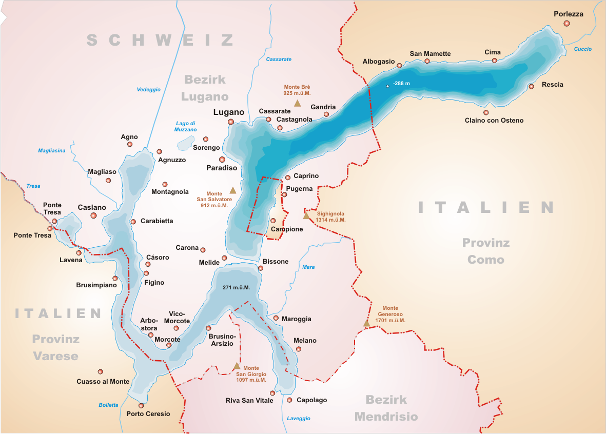
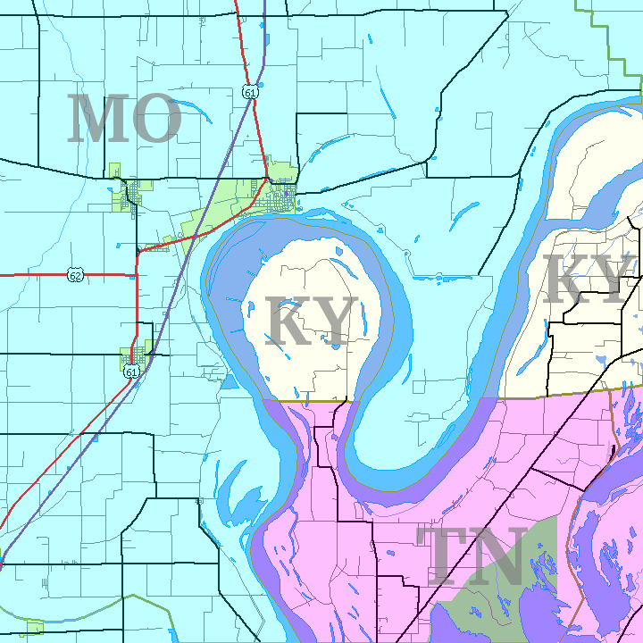
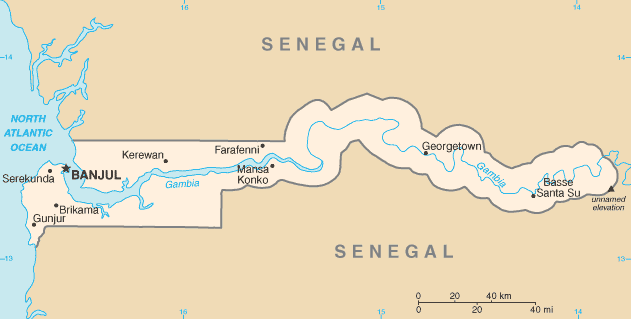
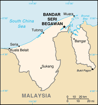
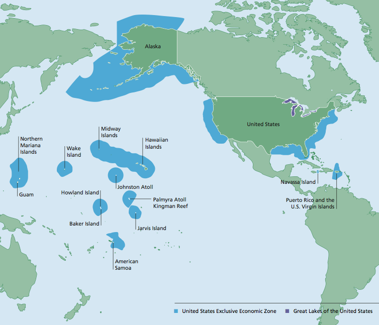
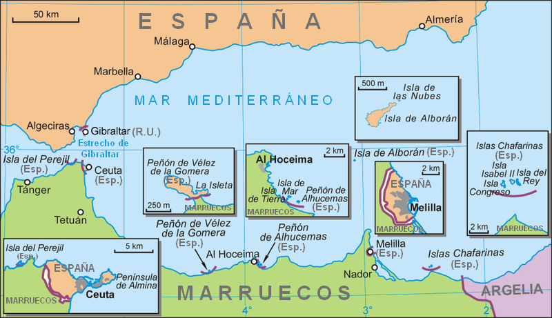
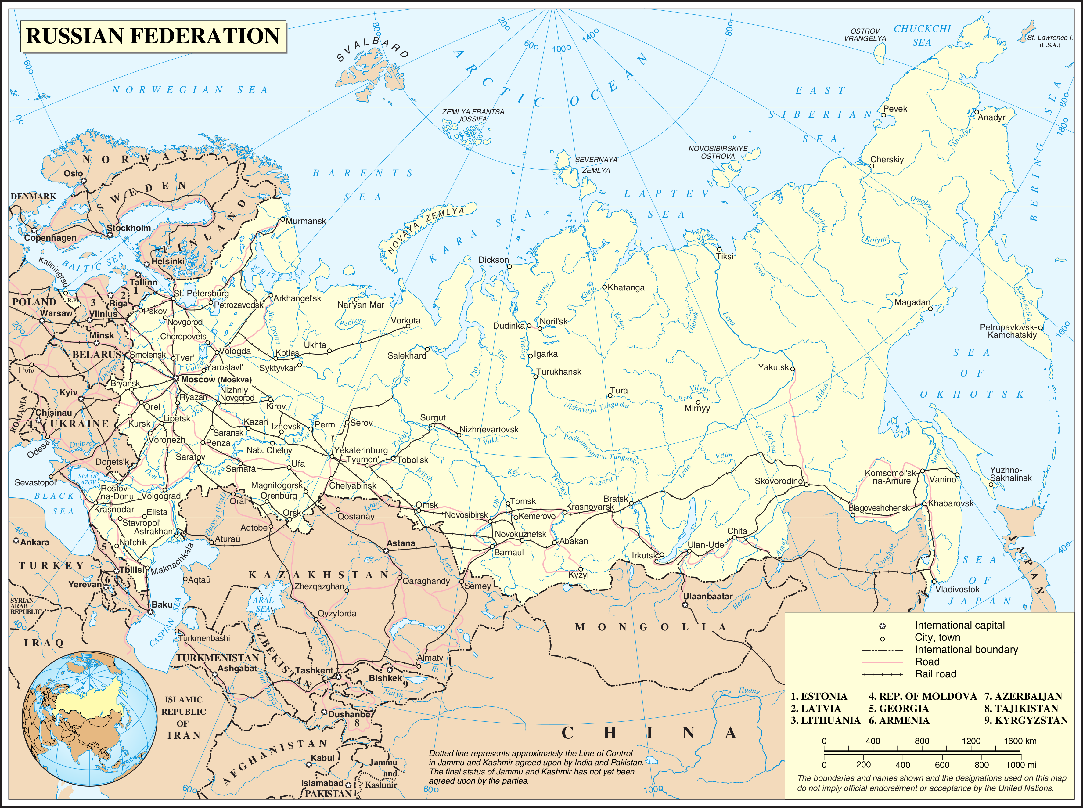
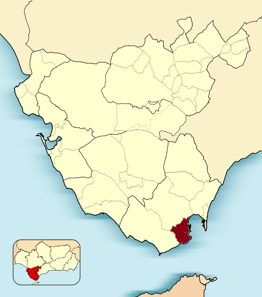
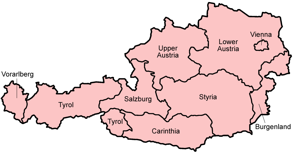
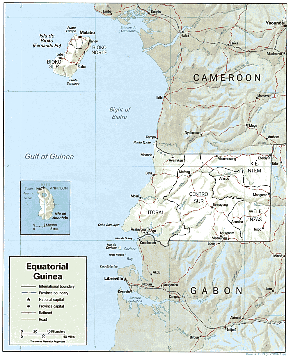
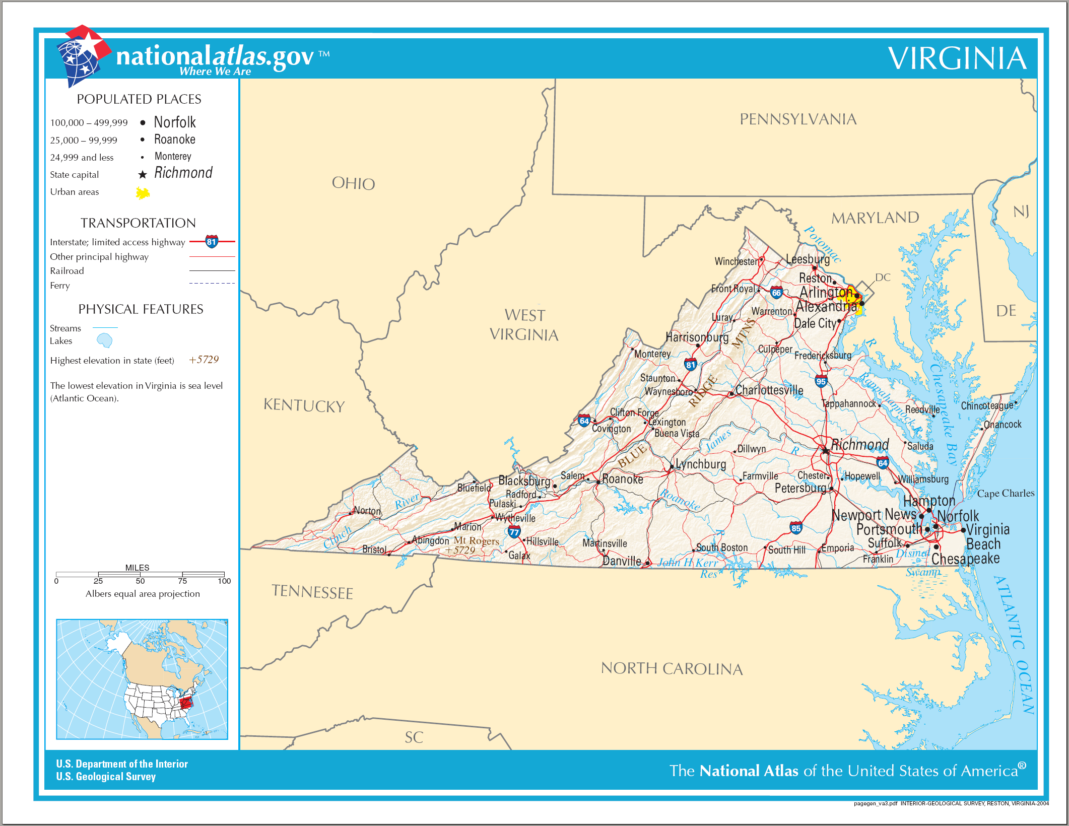
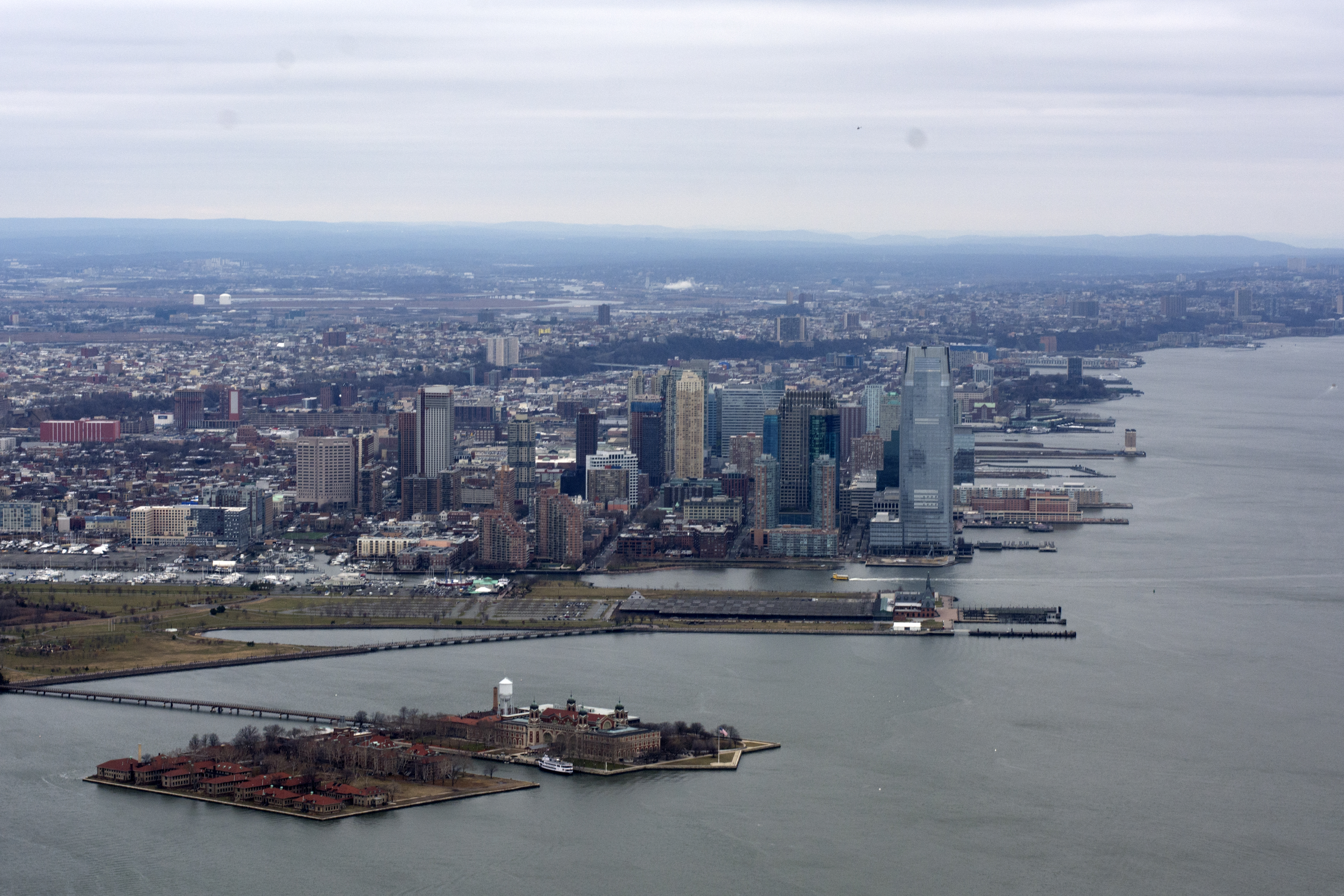
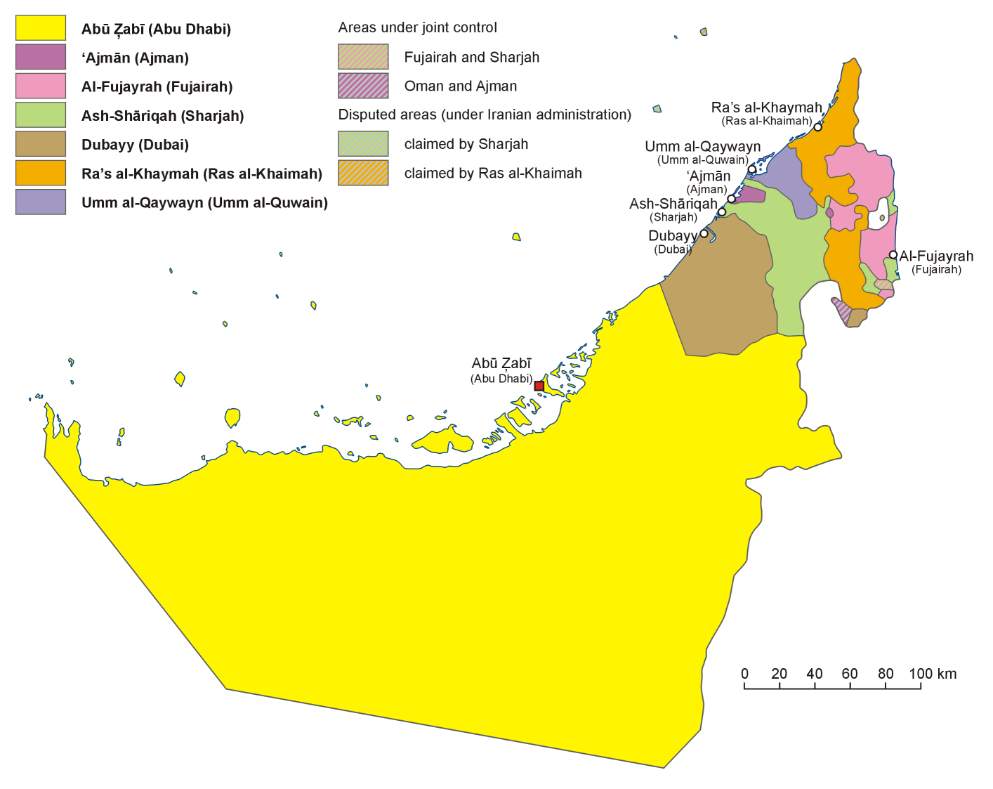
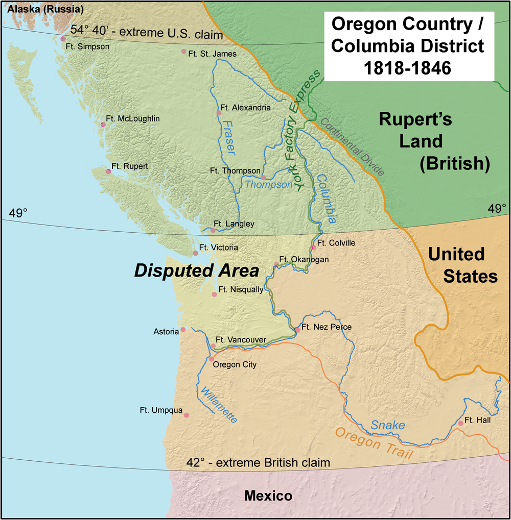
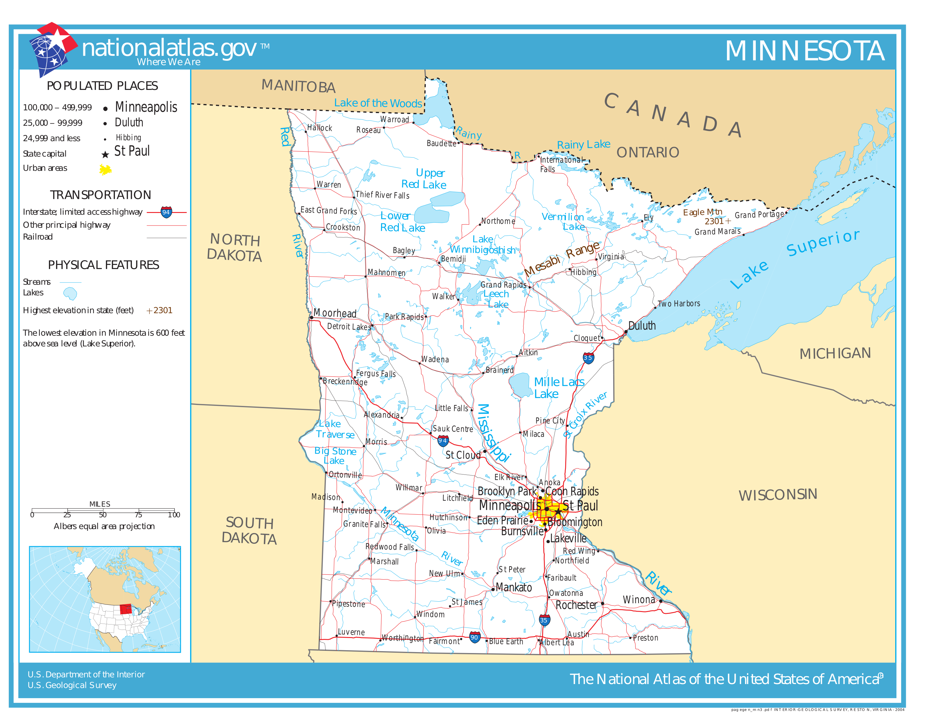
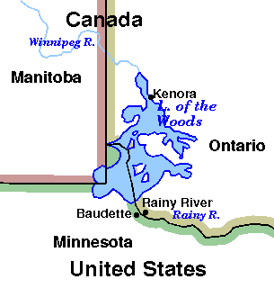