|
Reflections 2016
Series 7
April 23
Mississippi River XIII: "Up North" to Lake Itasca
| | "Up North" We are now ready to continue upriver, and should look ahead to see what's there. For this we have to refer back to 2011/24 when in New England , specifically in ME, NH, VT, and found we were in the North Woods. We pointed out that that term covers the huge east-west forest that covers regions from New England to over a large part of Canada north of the Great Lakes, ending up in the Upper Midwest, and its scientific name is the Laurentian Mixed Forest, named after the St Lawrence River. But while I was able to show a map of the Midwest section, I couldn't find one that covered the entire binational region. The following two I've now found are less than perfect, but do illustrate what we mean.
https://mylifeasaninteriorplain.files.wordpress.com/2011/12/north_america_vegetation.jpg
http://www.evergreentrad.com/wp-content/uploads/2011/12/whitepinepinusst-1899-crop-2-enhanced.jpg
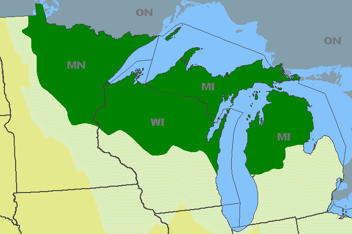
| | | | The first one is very rough in showing natural regions of North America, but does show in light green what they call "Mixed Coniferous-Deciduous Forest", a blend of the adjacent regions in dark and light green. The second map seems a bit off the mark, since its purpose is to show the distribution of just white pine (which is, of course, coniferous), and not referring to a mixture of types. But the dark green shows just the regions of New England, Canada, and the Upper Midwest we're talking about that are referred to as the North Woods. So now we can show again the map we did in the original posting that bring us to the North Woods of MI, WI, MN in, appropriately, forest green. In any case, this mixed forest has characteristics of each of the other two: conifers such as pines, spruces, and firs, and deciduous trees such as aspens, oaks, paper birches, mountain ash, and maples. But it fails to explain what the pale blue and beige areas are all about, so let's try further.
http://pubs.usgs.gov/fs/fs-0059-99/figure2.gif
http://www.myminnesotawoods.umn.edu/wp-content/uploads/2007/04/MN-four-biomes-236px.gif
| | | | But it's the North Woods that's now of particular interest, and I'm pleased with this map that shows it particularly well. It runs a border around the North Woods, setting them off from the rest, and it shows in red the metropolitan area of MSP, where nearly 60% of Minnesotans live. The North Woods are used for recreation, forestry, and mining, notably for iron ore in the so-called "Iron Range" region, where the Mesabi Range is the best known. The deciduous forests are now partially cleared, settled, and farmed, as are the prairies, now given over to intensive agriculture. | | | | Now that the centers of population and recreation are clarified, I'd like to indulge in a bit is satirical teasing about each of the two areas, based on my half-century of familiarity with the region. What I like to abbreviate as MSP, is, as you know, usually referred to as the Twin Cities. This is done on the basis that having two cities next to each other as though this is unique to Minnesota—forget Dallas/Fort Worth further down on I-35, San Francisco/Oakland; Tampa/St Petersburg (and Clearwater!), and many more. Also forget twin cities that have merged, such as Buda and Pest to form Budapest, and New York (Manhattan) and Brooklyn to form today's New York. | | | | But the feel that the Twin Cities are so unique and so fundamental to the existence of the Minnesotan world that, unbeknownst perhaps to outsiders, the designation is very often reduced locally in everyday speech so simply The Cities, as in "When will you be coming back to The Cities?", which, out of context, sounds a bit bizarre. | | | | As for the recreational area, it is universally known in The Cities as Up North, where apparently, no other directions in Minnesota are important. Well, maybe they aren't. While northern Minnesota is huge, saying you're going Up North is adequate information for friends and family. But no, it gets a bit more bizarre. An alternate designation is Up to the Lake or Up to the Cabin. It's perfectly common to hear "I'm going Up to the Lake late Friday and will be back in The Cities late Sunday". No lake need be designated. You may or may not know where the individual may have a cabin, or a friend's or a family cabin, or if he rents a unit at a resort, no more than if he were talking about "out in the garage". You don't have to know what his garage looks like any more than you have to know just what lake he's talking about, or if it's near or far. It's just a given, a way of life. Lakes located Up North are apparently generic. | | | | | | I know whereof I speak. My in-laws had a cabin that my father-in-law had built himself. If Beverly and I were visiting during the summer, we'd very likely end up spending a weekend Up at the Lake/Up at the Cabin/Up North. Both my in-laws were working, but late Friday afternoon the car got loaded and off we'd go for a four-hour ride to the town of Pine River, then onto dirt roads to the cabin and lake, arriving in darkness. We'd unload the car by the light of the car headlights until we got inside. Saturday was relaxing, early Sunday less so, knowing a long haul was ahead again, then Sunday evening we'd finally be back in Bloomington. I did it only several times in the decades I visited. Others do it all the time.
This brings to mind a couple of family stories, one of which I was involved in personally. I've said my father-in-law sometimes had an immigrant mentality, which is why he moved his family to Bloomington during the war. Another example is the time I heard about, which had to have been sometimes in the 1950s, where he came home one day and announced to the family that he'd bought land on a lake. He hadn't told anyone of his plans, least of all my mother-in-law, but she apparently resisted resorting to strangulation. Anyway, she, Beverly, and Beverly's brother Phil decided to make the best of it and asked him where it was. He told them "Yale Lake". Knowing he had pronunciation problems in English, they tried to confirm that that was actually the name, but he just mumbled something in reply, so they let it go, and proceeded to tell everyone the prestigious name of the lake the family now owned property on.
But, though he spoke fluent English, he did have pronunciation problems, especially when excited. For instance, every once in a while, I became "Wince". Once when I was driving the family somewhere, he suddenly realized we needed to turn, and excitedly said "Weer left, Wince!" In addition, he was of the school that thought that it was Yack and Yill that went up the hill. The fact that the family name was Johnson (Yohnson) didn't make life easier. So when the family first went to see the plot of land he'd bought Up North, his "Yale Lake" turned out to be—unbelievably—Jail Lake, so they had to change what they'd told people about their lake to a decidedly more downmarket name.
|
| | | | Day 22: Minneapolis to Grand Rapids After breakfast, we're ready to drive Up North, and we take 4th Street SE right outside our door at University Inn, connect to Main Street, and pass Nicollet Island on our way upstream. It's our intention to drive as close to the Mississippi as possible, although we know we won't see any more on the narrower river here than we saw on the broader one down south. It's just a matter of driving along as closely as possible, taking a peek here and there, and also getting a better look on bridges across the river.
http://www.fhwa.dot.gov/byways/Uploads/static_maps/000/000/398/Minnesota_Section.png
http://50.59.38.231/grandrounds/images-map/map_NE1.gif
| | | | The first link is to the northern end of the Great River Road. Landmarks along our question-mark route are St Cloud, Little Falls (not shown, but the Lindberg State Park is), Brainerd, Grand Rapids (our stop for tonight), and Bemidji (our stop for tomorrow night). Bemidji is the stop, since Lake Itasca itself is in a rural area best accessed out of Bemidji. The length of the Mississippi between St Anthony Falls in Minneapolis and Lake Itasca is 793 km (493 mi). | | | | The second link shows our start. It again is presented for completeness, since it shows the northern end of the Grand Rounds in Minneapolis beyond Nicollet Island. Only the odd riverside park provides something to see, but there is something worth mentioning on the upper right of this map. This is the newer St Anthony, the place that adopted the name after the original one at the Falls became Northeast Minneapolis. The St Anthony Parkway you see also refers to this place.
http://www.stonybrook.edu/gmaps/minneapolis/_Media/northstar_888.jpeg
http://www.northstartrain.org/images/ExpansionMapRev1sm.jpg
| | | | Our route along the east bank of the river, through local towns, is parallel to the Northstar Line, the reconstituted commuter line that leaves from Target Field, as we noted, and which is shown on the maps. The first bend in the route is where the line crosses the Mississippi, Nicollet Island, and the East Channel, to gain the east bank and continue upriver. Take note of the town of Coon Rapids, mentioned earlier. As we said, it's the current head of navigation on the river, since there's no lock at its dam. As we pass Anoka, we can see the Anoka station to our right. Humorist Garrison Keillor is from Anoka. The second link shows the proposed expansion of the Northstar Line, which would extend the present 64 km (40 mi) of the route by another 43 km (27 mi) and bring it to St Cloud, our first stop of the trip. St Cloud presently has an Amtrak station (I went to peek at it), and that would presumably be used for the commuter line.
http://www.dot.state.mn.us/passengerrail/images/empirebuildermap.jpg
http://www.dot.state.mn.us/passengerrail/images/passvisiondesignmap.jpg
| | | | Since we're talking about rail and about Amtrak, this first link shows the route of the Empire Builder through Minnesota. After Grand Forks ND and Fargo ND, it crosses the Red River we discussed earlier and cuts diagonally across MN via St Cloud and (ahem) The Cities to Red Wing, then crosses over to LaCrosse WI, places we've visited. It's obvious that the only Amtrak route here would connect major destinations on the West Coast via MSP to Chicago, and therefore would run diagonally. But the second map presents high hopes. The only other state I know of that is actively restarting and extending commuter lines is Massachusetts, around Boston. I'm so glad to see in MN not only the light rail and Northstar Line developing, but also future plans like these. The Phase I (gold lines) would continue adding commuter rail around MSP, to Duluth, MN's third largest city, and along the diagonal route in both directions. Moorhead MN is a twin city (fancy that!!!) of Fargo ND, so Phase I de facto gives Fargo service to MSP. The green Phase II lines would later return service to locations of lower population in the S and SW, but the line on the ND side is, I'm sure, pointing across the US/Canadian border toward Winnipeg MB. Remember this is the Red River valley, where the river flows north through Winnipeg. St Paul Union Depot would be the focus of activity, although there is also talk of once again adding Minneapolis as a stop for long-distance trains, at Target Field.
http://www.dot.state.mn.us/ofrw/maps/MNRailMap.pdf
| | | | Considering there is as we speak only the Empire Builder route and local service in MN, it is stunning to think that in the heyday of passenger rail service, almost every town everywhere was connected to a rail network. First passenger rail was lost leaving just freight trains, and even some of those lines were abandoned. This is a map of freight railroads in Minnesota, and it doesn't even show the abandoned lines. Four railroads, in color, own the most track. It can be assumed that all these lines once had passenger service. Compare the future plans we just saw, and you'll see that it's a matter of reusing some of these routes. Grand Rapids (not shown) is where the green lines converge SW of Hibbing. We'll stop at the former station there and in Bemidji, just to take a look at where there used to be stations for passengers. | | | | So we've reached St Cloud. When first in MN, I assumed that, since it was named after the city near Paris, it had the same pronunciation, since in French, "Cloud" sounds just like the English word "clue", but here, it's totally anglicized into one big, willowy cloud. This is St Cloud (Photo by WikiMRVM.R.Voigt), but the view is to the south here, to where we just came from. Moseying around, we follow a street sign saying Riverside Drive, and ride from some distance in a pleasant residential neighborhood right along the river, in the upper left side of the picture (click). We also cross the river to downtown to look around for a quick visit. The town owns and operates a hydroelectric dam here to generate power.
http://www.minnesota-map.org/minnesota-road-map.gif
http://mississippiheadwaters.org/maps/mhb-counties-map.jpg
| | | | Mississippi Headwaters The first link is to a good map of Minnesota (click) for general orientation from now on. Do use it to follow our route through Coon Rapids, Anoka, and St Cloud, and now beyond to Little Falls. The second map is more precise, just for the river route through this part of the river called the Mississippi Headwaters. Use this one, too, since it concentrates on the river better. | | | | We come now to Little Falls, site of the boyhood home of the aviator Charles A Lindbergh. By now we should know that any river features appearing in a name have to be long gone, and so there are no longer any little falls in Little Falls. But the local dam does generate hydroelectric power for the surrounding area. We cut through town and cross over to the west bank, then go a bit south, to where we find Charles A Lindbergh State Park, named not for him, but for his prominent father and US Congressman. Yet in the park, right along the river, is the 1906 boyhood home of the aviator (Photo by McGhiever). It's nice enough to see the outside and the view of the river from here, and it's closed anyway this late in the season. Now I can refer back to St Louis, when I discovered Lindbergh's connection with that city. Along with having visited Roosevelt Field on Long Island, where he flew from (now a shopping center), this completes my Lindbergh trifecta. | | | | We pass through Brainerd, which is where our return route south will eventually cross our present route in an X. At Aitkin (rhymes with achin' [back]), we purposely go left at an intersection to where the river has to be (it is) to get a glimpse of it. Otherwise, we proceed on to Grand Rapids for the rest of the afternoon, and night. | | | | Arriving in town, we come across a reminder of Frances Gumm, who was born here in 1922 and left at age four to became a Hollywood star with a tragic life, dying in 1969 at age 47 in London. But closer study of her time in Grand Rapids already foretells the sort of life awaiting her. Since we're in Grand Rapids, we'll summarize just the story of her childhood here and then up to age 13 elsewhere. | | | | Her parents were vaudevillians who settled in Grand Rapids to run a movie theater which also had vaudeville acts. Her mother was an overbearing show biz mom named Ethel Milne, and her father was Francis "Frank" Gumm. When her mother found she was pregnant with her third child, she tried to terminate her pregnancy by unsuccessfully throwing herself down a flight of stairs. Nevertheless, Frances Ethel Gumm was born in 1922 and named after both parents. The whole family called her Baby. | | | | It's impossible to know why Ethel did what she did, but it could have been the serious rumors of Frank's affairs with young men and teenage boys, including ushers in his theater, might have been a factor.
https://s-media-cache-ak0.pinimg.com/736x/01/ef/26/01ef267ab828313d15f1e56a028a2e6a.jpg
| | | | Two years later, in 1924, Baby, at age two (picture above; does the face look familiar?), joined her older sisters Mary Jane ("Suzy") and Virginia ("Jimmie") in a dance routine on the stage of her father's theater during a Christmas show that included Baby's first solo, "Jingle Bells", accompanied by Ethel on the piano. The "Gumm Sisters" performed there for the next two years. I had assumed they moved to California then, in 1926, just for reasons of show biz aspirations, but it turns out that they primarily had to leave, since Frank's actions grew so out of bounds for Grand Rapids sensibilities. They moved to Lancaster, north of Los Angeles, where Frank did then purchase and operate another theater. Ethel, as the girls' manager, tried to get them into movies, and had them endure countless classes, auditions, and performances. The Gumm Sisters did make some film shorts together as a trio. This is Frances c 1928 at six years (familiar yet?):
https://s-media-cache-ak0.pinimg.com/736x/aa/17/d0/aa17d0834468c11d12ddae3d765ff053.jpg
| | | | From 1926 to 1932, they also made hundreds of stage (vaudeville) and local radio appearances all along the West Coast and as far east as Detroit, and in 1932, Baby Frances became the center of the act as Baby Gumm, since she was by far the most talented and popular. These are two undated photos of the three Gumm Sisters:
http://www.judygarlandmuseum.com/images/judy_garland_as_child.jpg
http://a5.files.biography.com/image/upload/c_fit,cs_srgb,dpr_1.0,q_80,w_620/MTE5NTU2MzE2MjIyNzUyMjY3.jpg
| | | | In 1934, the Gumm Sisters were performing in Chicago at the Oriental Theater with comedian George Jessel. After their name drew laughter from the audience (legend has it that they were once erroneously billed in Chicago as the Glum Sisters), Jessel encouraged the girls to choose a more appealing stage name. He suggested "Garland". There are several theories as to the origin of that choice. The most logical to me is that the 1934 classic screwball comedy film "Twentieth Century" was playing at the Oriental at that very same time, and the female lead, played by Carole Lombard, was named Lily Garland. | | | | By late 1934, the three Gumm Sisters were being billed as the Garland Sisters. Also in 1934, a popular Hoagy Carmichael song appeared called "Judy", and Frances chose this to be her new first name. In 1935, the act broke up when the eldest sister flew off to Reno to get married. Frances, again clearly the most talented of the trio, could now become a solo act. She had now become Judy Garland and was soon discovered by MGM and signed to a contract at age 13. The rest of the story of Frances Gumm you already know. But what a difference a name makes.
http://static.panoramio.com/photos/original/49896016.jpg
http://www.visitgrandrapids.com/wp-content/uploads/2015/05/area-attraction-map-grand-rapids.png
| | | | And what was the reminder of all this as we drive north into Grand Rapids? It was the 1892 Judy Garland Birth House, above, maintained by the historical society as a museum. It's been moved four times from its original location in town, where a clapboard house of this style fits in far better than at its current location. It's now on Highway 169 well south of town (see map), a big boulevard characterized by shopping malls and large parking lots. We drive up to it to take a peek—it's only open on weekends, anyway—but it seems misplaced. Instead let's listen to this YouTube video (2:42) of Frances Gumm, aka Judy Garland, singing Over the Rainbow. She was about 17 in 1939 when she sang this, playing a much younger Dorothy.
http://assets-upmpaper.upm.com/images1/north-america/blandin-mill.jpg
| | | | Hold on to the map of Grand Rapids. We drive up US-169, and just before the big intersection, we cross the Mississippi, which by now has swung west. We pull left and stop and see what is called here the Blandin Reservoir (see above picture, looking west). Grand Rapids is named for the 5.6 km (3.5 mi)-long series of local rapids that characterized the river here. But we're not surprised that today there are no grand rapids in Grand Rapids. In the early 20C, the Blandin Paper Mill, on the right, built the dam you see that forms in the river the "reservoir" in the distance. | | | | We now drive up to the intersection with US-2, which is right where Frank Gumm's theater was located. We're in the center of town, and we check out the former rail station referred to earlier, which is now some sort of tourist information office. But the town is attractive and in a nice residential area a few blocks north of US-2 (which we use in the morning to continue west), we check in at the Morning Glory B&B, where we have a nice room on the main floor, which even has its own entrance to the front porch. | | | | Day 23: Grand Rapids to Bemidji & Lake Itasca In the morning, we have a nice long conversation over breakfast with the husband-and-wife innkeepers about their running a B&B and my running a travel-and-language website. Then it's off to Bemidji (see maps) seeing on occasion the Mississippi in a very open landscape of forest and lakes:
https://childlake.files.wordpress.com/2011/10/hsitesmaplarge.jpg
http://www.casslake.com/images/largemap.jpg
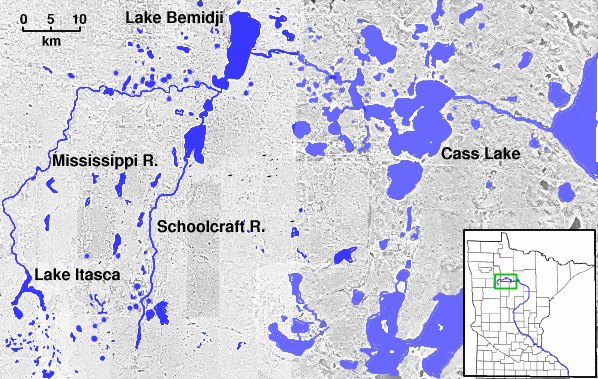
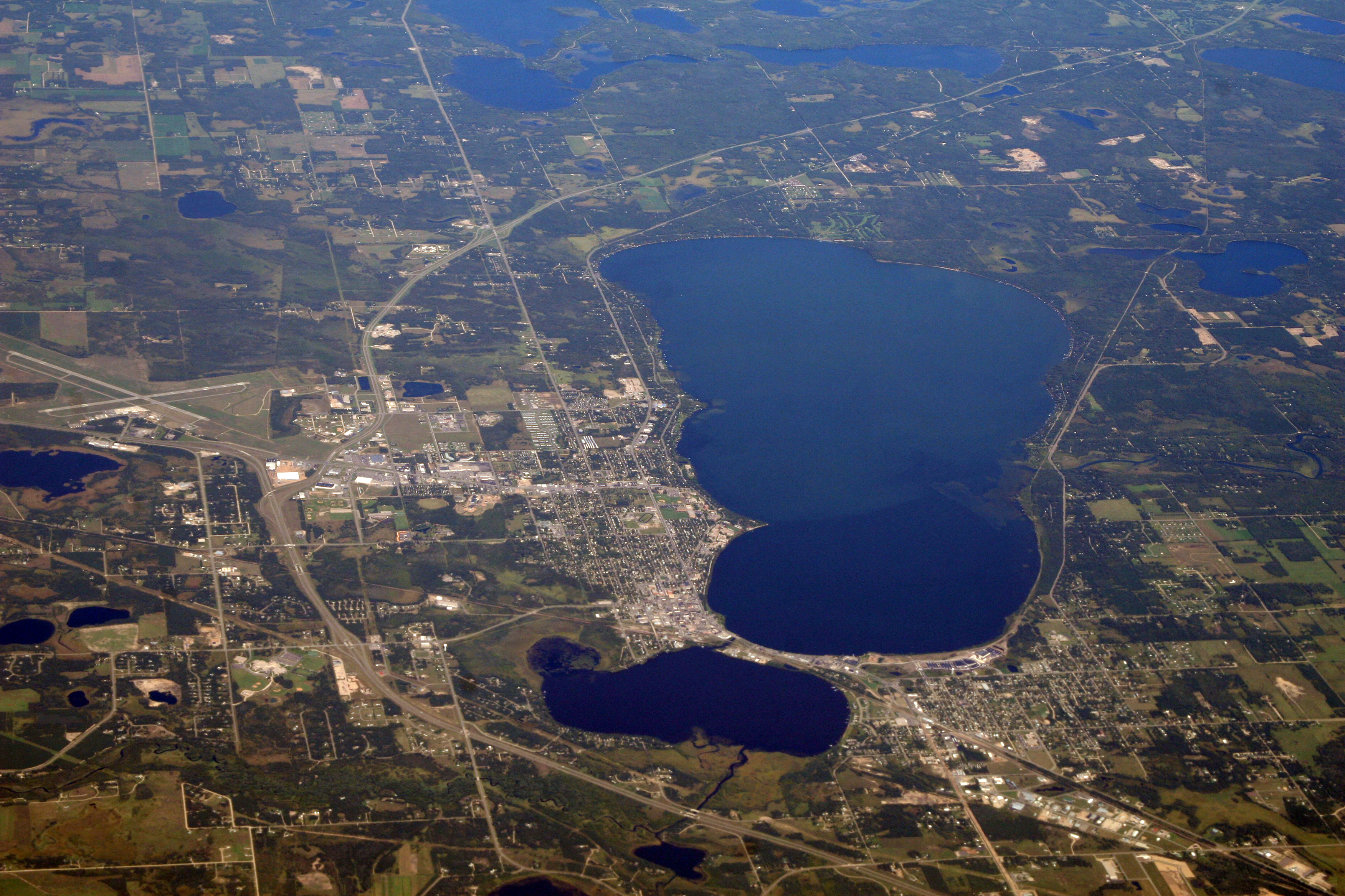
| | | | As this first map shows, shortly out of Grand Rapids we enter both the Chippewa National Forest, and, perhaps more interestingly for many, the Leech Lake Indian Reservation, the home of the Leech Lake Band of Ojibwe. We'll see Leech Lake itself later in the trip, when we spend the night in Walker (see both of these maps). Let's discuss the lakes we do see right now, on the second map (click), where you can clearly tell how they're connected by the Mississippi, although we're not always driving right next to it. We get a peek at Lake Winnibigoshish from the road. Its name comes from the Ojibwe language meaning "brackish water", and is related to two other names we all know. For one, Lake Winnipeg in Manitoba. The other involves a Siouan-speaking tribe of Native Americans who call themselves the Ho-chunk Nation, which is their endonym (internal name). But the Algonquian name for this tribe, that is, the exonym (name applied externally), is Winnebago, which has become popularized due to a brand of motor homes. | | | | We then come to Cass Lake, which was visited by General Lewis Cass on an expedition in 1820. Low water prevented them from going further upstream, and so they designated Cass Lake as the headwaters of the Mississippi, since downstream from here, the river is navigable throughout the ice-free season. But a dozen years later, in 1832, Henry Schoolcraft, a member of the expedition, came back and went further upstream to Lake Itasca, and is credited with designating that as the source (more to follow). Later we'll pass through the town of Cass Lake again on the way to Walker, but now it's on to Bemidji, located at the south end of Lake Bemidji and adjacent to Lake Irvine (click). | | | | To concentrate on the river and lakes, without roads in the way, look at this map (Map by Decumanus). From Lake Winnibigoshish, follow the Mississippi upstream through Cass Lake, Lake Bemidji, and Lake Irvine, to a fork. Here the Schoolcraft River, named after you-know-who, enters from the south, while we continue west to the upside-down Y of Lake Itasca. | | | | But now we're in Bemidji, and this aerial view (Photo by Doc Searls) shows us everything. Start at the bottom center, where the petite Mississippi, coming from Lake Itasca, trickles into Lake Irvine, then goes under the causeway into Lake Bemidji, to leave on the right, at the end of the darker water. From the lower right, our highway, US-2, enters, as do the rail tracks, over the causeway (and the Mississippi), to reach downtown, clustered nearby. The tracks continue to the former passenger station we mentioned earlier, but we park downtown and walk around. (While we'll stay downtown, then visit Itasca, we'll be back to the northern part of town for our hotel later—you see how US-2 is such a wide boulevard at that point, without the charm and walkability of downtown.)
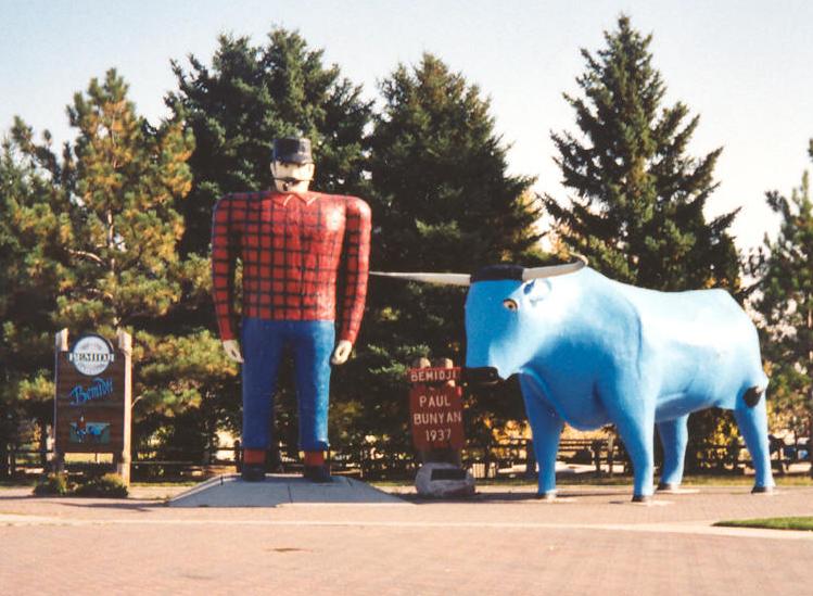
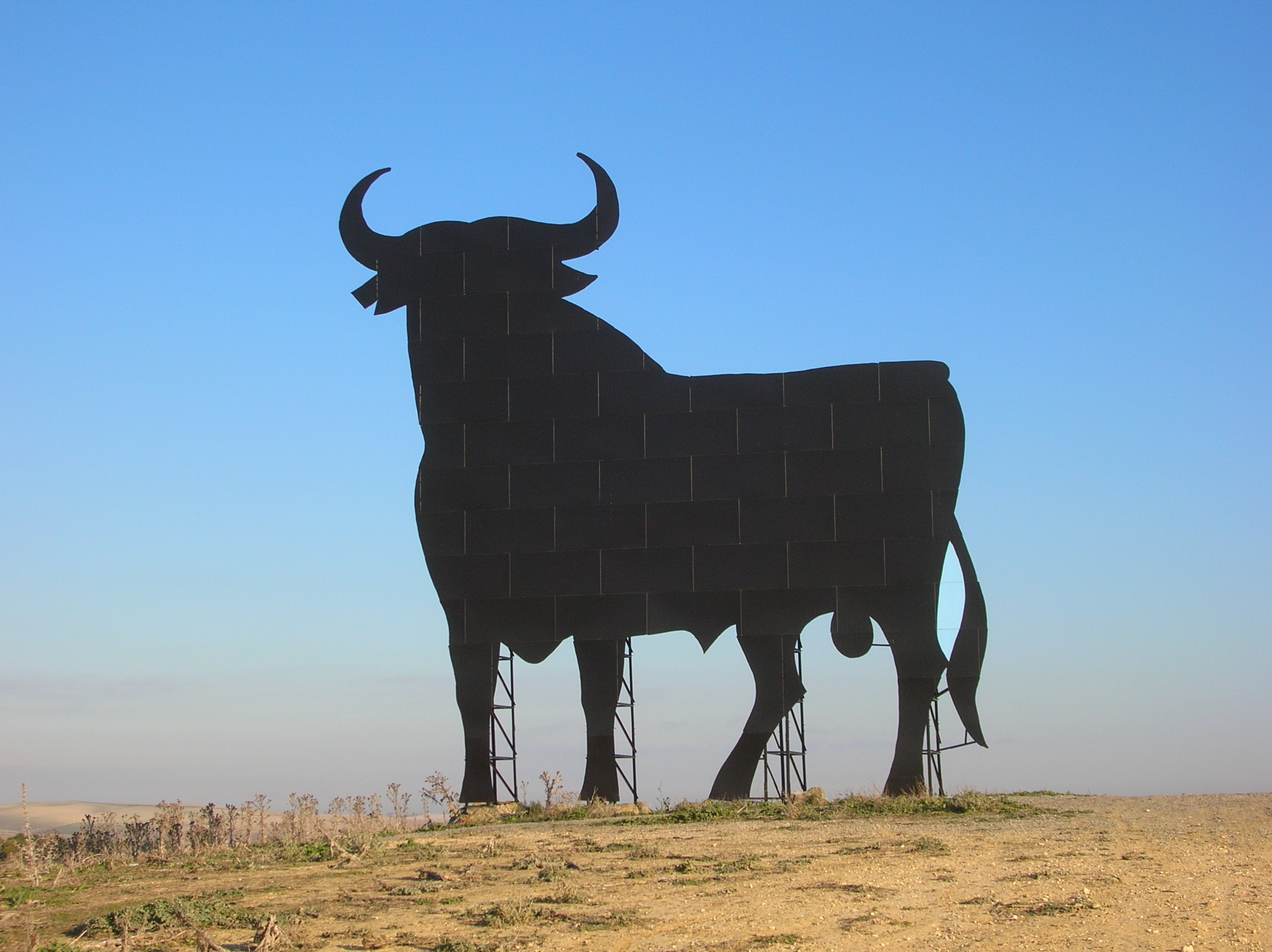
| | | | Since the area from here to Lake Itasca is totally rural, Bemidji is the urban center of the area, and you can see why it calls itself "the first city on the Mississippi". After walking over the Mississippi and back, we go to that little park right there that sticks out into the lake to see the major feature of Bemidji, the statues of Paul Bunyan & Babe the Blue Ox. | | | | Paul Bunyan is the giant lumberjack of American folklore, who is usually accompanied by his colorful bovine companion. Tall tales of his superhuman exploits were developed in the oral tradition of loggers in logging camps. Many US states across the North Woods from Maine to Minnesota, claim him as their own, as do parts of Canada. His likeness appears in many of these North Woods locations, and beyond. But something unusual then happened with this folkloric character. In 1916, freelance writer and adman William B Laughead wrote a promotional pamphlet for the Red River Lumber Company, in which he popularized the figure for commercial purposes. Laughead created the first pictorial representation of Bunyan. He increased Bunyan's height to impossible proportions, making him a giant. And he gave the name "Babe" to the blue ox. | | | | There are a number of hypotheses about Paul Bunyan's surname, but the commentary focuses on a French Canadian origin. There was a Québecois expression, now out of date, that was a euphemism for Bon Dieu! (Good God!) that took the altered form bon yenne, which, it is suspected, is the basis for THIS Bunyan.. But the English surname Bunyan is, oddly, just an alternate spelling of "bunion", describing a painful swelling of the big toe. | | | | In the 1930s, Bemidji wanted to attract visitors by reflecting on the logging and lumberjacking history of the city, and so built two promotional statues as a roadside attraction. They used the winter carnival of January 1937 to introduce the two as carnival mascots. This is Paul and Babe today (no attribution). If the statues appear a bit klutzy, consider them folk art, or primitive art. Paul is about 5.5 m (18 ft) tall, and Babe is about 3 m (10 ft) tall. From nose to tail, Babe measures about 7 m (23 ft). | | | | | | There's another example of tradition turned into advertising turning into a local icon. Those who have driven in Spain will probably have seen the Osborne bull (Photo by Grez), as there are a number of them—this one is near Seville. It's a 14 m (46 ft) high black silhouette image of traditional Spain in the form of a bull in semi-profile. Starting in 1956, the Osborne Sherry Company, which had been founded in 1772—more tradition—erected these, with writing on them, as advertising billboards near major roads throughout Spain to promote their products. The original image was smaller and slightly different. Then, when restrictions appeared requiring billboards to be 150 m from a road, the
current larger image was used to comply with the law. But then, in 1994, all roadside advertising was banned, so the bulls had to go to. But by this time, they were so well-known nationally that the public response resulted in the signs being retained as icons of Spain, but with the advertising blacked out. The courts allowed this on the basis that they'd become part of the landscape and had "esthetic or cultural significance", making them public domain images. So it's the same story as Bunyan and Babe—tradition to advertising to icons.
|
| | | | We leave Bemidji to spend the afternoon at Lake Itasca in Lake Itasca State Park, Minnesota's oldest state park, founded in 1891. There's a fast road that gets there in a slightly roundabout way, but instead, we've checked out the local roads, nicely paved, that cut diagonally to the park in a rural area closer to the river and going through Becida (see MN map). This is the section of the tiny Mississippi (Map by Decumanus) that we're relatively close to, crossing it three times. The first shows it as a beautiful, winding stream in a reed-filled wetland. The second gives us a quaint view with high grasses. Here the river is just a stream about 2 m/yd wide. The third view was from a raised bridge, so that the river was just a narrow stream below. We end up coming due south to the park and lake, both of which face north, which is counterintuitive, since we always picture the Mississippi flowing south—but this is the end of that question mark the headwaters make. This map shows how Lake Itasca has three arms, and how it looks like an inverted Y. We're headed for the top of the North Arm. | | | | We enter the park on a beautiful autumn day, but it is the beginning of the off-season, and most facilities such as campgrounds and the lodge are already closed, although the entire park and visitor center are available. Still there's a $5 auto fee, so we pull up to a tiny building to pay it, but it, too, is unmanned in the off season. But how clever. There are instructions to take an envelope, fill out the forms on its back and tag, keep the tag to put on your dashboard, and drop the envelope with the payment into an adjacent slot. Works for me.
http://media-cdn.tripadvisor.com/media/photo-s/01/3a/33/06/headwaters-area-trail.jpg
| | | | This map of the entry area is turned on its side, with north, roughly, on the left, where we enter. The Park Drive crosses the river (off the map), and also mentions the Wilderness Drive, which we'll do later. You see how many times you can cross the river just in this area, but we take the short Headwaters Trail over a wooden footbridge, right to our destination. This is IT! We're THERE!
http://m1.i.pbase.com/o4/83/606383/1/59308661.bm_593333_MississippiHeadwaters.jpg
| | | | We'll start with this standard iconic view of Lake Itasca with the Mississippi River flowing (roughly north) out of it. My other time here, probably in the 1960s, I was impressed by that over-excited tourist sign, now much less so. After all, we know where it goes, since we've now seen it end-to-end between here and South Pass. I also argue with the distance mentioned. The total distance varies according to who's measuring it, but the US Geological Survey's number is 3,730 km (2,320 mi). We can add that here, we're 450 m (1,475 ft) above sea level and that Lake Itasca has an average depth of 6-11 m (20-35 ft). But the picture is über-pretty, ready for a postcard. The autumn day really was as nice as this, though. | | | | But we have to mention the stepping stones, which is the thing I remember most about being here before. They are officially the very first crossing of the Mississippi River. When they look as neat as they do in this picture, you can walk across them, and Beverly and I did so, both ways, those years ago. It's just as well that that was long checked off my bucket list, because this time, things were less than perfect. The water flow seemed higher, the stones were more out of line, there were branches and debris piled up along the stones on the lake side. It didn't look inviting, although I considered it, but better safe than sorry--I didn't need a mid-afternoon bath. | | | | But this small, clear brook will eventually carry runoff from nearly 2/3 of the US and enough silt to make the muddy plume at the mouth visible from space. But here, you can not only see the bottom, but can wade across, if the fancy strikes. However, the only fancy that struck me was to lean down and dip my fingers in the water on the river side of the stepping stones. | | | | If that introductory picture was an almost-postcard, then this view (Photo by Christine Karim), although it is on an overcast day, reflects real life more. And then I walked a few steps downstream, and found this log bridge, which I do not remember seeing on the earlier trip (although it could well have been there):
http://www.johnweeks.com/river_mississippi/pics01/logbridge01.jpg
| | | | This shows again more what the weather is really like today on our visit, and it's obvious that the previous picture was taken from this log bridge. Here, you do see people attempting the stepping stones. Later, I checked a list of all the crossings of the Mississippi, and the first was called "headwaters dam covered with rock–-pedestrian ford" and the second was called a "footbridge". People were managing the footbridge as well, and so would I. | | | | You see the low height above the water, though it looks much higher from eye level when you're standing on it. It only has the width of two feet placed closely side-by-side. I now understand why aerialists use a balance stick, because there's no way I would have made it there and back unless I held my arms WAY out like a bird, and also stepped along VERY FAST. Thus, I again avoided a mid-afternoon bath, yet did get to visit both banks. | | | | But the nicest part about being at The Source involved a very well-placed park bench and me joining a gentleman sitting on it for a little talk on this nice autumn day as we both admired the scene. He loves this spot and comes periodically, and has seen his share of people falling off the stepping stones. It was pleasant to just sit and ponder for a while. | | | | Well, actually, there are two things to ponder besides the natural scene. First, it's not exactly all that natural a scene--sorry. You may be aware that Central Park in New York started out as an uninteresting landscape, and that Olmstead and Vaux imported trees and soil, crafted streams and ponds to make it what it is. Central Park looks absolutely natural, but it's mostly man-made. Well, something similar happened here at The Source. In the 1930s, the Civilian Conservation Corps (CCC) was brought in to "improve" the location. The whole area where we are now was a natural swamp, and the Mississippi exited from the lake at a point rather far east of this central area, so bulldozers were brought in and it was all changed. The swamp was drained and the channel was centered to create a more "pleasant experience" for visitors. You didn't think those stepping stones were natural, did you? But the result is worthwhile, even if most visitors are unaware that The Source as they experience it was man-made. It's just another example of how Life Imitates Art to make a more dramatic, show biz presentation. | | | | The other thing to ponder is the name "Itasca". Do you like it? Do you suspect it's a Native American name? I think the name is OK, though not marvelous, and anyway, we have no choice. When Henry Schoolcraft found the lake, that's what he named it. Finding the source was a romantic 19C quest--Zebulon Pike and others searched for it. But an Ojibwe chief named Ozawindib ended up guiding Schoolcraft here in 1832. I hope neither missed the lack of stepping stones at the iconic location. | | | | Schoolcraft had been active as an official in Michigan and named several of Michigan's counties. He amalgamated ("frankensteined") together parts of words from various Indian languages (some even out-of-state!) and from Arabic, Latin, and Greek, thereby creating faux Native American names with absolutely no basis in fact. Sometimes real Native American words were eradicated in favor of his made-up words that, romantically speaking, sounded Native American—at least to him. The Michigan counties he named are Alcona, Allegan, Alpena, Arenac, Iosco, Kalkaska, Oscoda, Tuscola. | | | | I looked up Alcona County, and at first, it was called Negwegon County, after a well-known Chippewa chief who was a US ally against Britain in the War of 1812. This is a name that would seem quite reasonable and authentic, until Schoolcraft got his hands on it and gave it its pseudo-Indian name. I don't know what the original names referred to in three cases (Alpena had been Anomickee, Iosco had been Kanotin, Kalkaska had been Wabassee). But we have some of his naming methodology here: Arenac is based on Latin arena "sand" with a Native American suffix, meant to mean "a sandy place" and Oscoda might be from two Ojibwe words, "ossin" (stone) and "muskoda" (prairie). But does Ojibwe allow joining of words like that or is that pure Schoolcraft trying to say "stony prairie"? | | | | Now to the point. "Itasca" may seem Native American, but it's nothing of the sort. Actually, it's a combination of two Latin words, very poorly put together by Schoolcraft. The explanation you always see is that he took Latin veritas "truth" and combined it with caput 'head", gluing them together, then lopping off the first and last syllables: [ver]itasca[put]. I fully believe that that's what he did. I am no Latinist, I just "do" modern languages, but I know how languages work. Not knowing Latin doesn't mean that we can't look at this job Schoolcraft did and shoot holes in it, ending up with a piece of Swiss cheese. Do you see any problems before we start? | | | | I checked my facts online. Schoolcraft couldn't, but he had access to dictionaries and grammars. So let's get started with some online research. I find several Latin words for "source" but down the list is caput "head" with the subcontext "(of a river) origin, source, head", so score one for Henry. | | | | The motto of Harvard University is well-known to be veritas, "truth". We see within it the root VER- which also appears in "verify, veracity, veritable, verily, verdict", all of which involve truth. (Though harder to see, even English "very" is based on that root.) But Schoolcraft's using this word in this form ends up with a meaning of "truth source". That wreaks havoc on his fundamental notion and makes it "veritable" nonsense. Where lieth the "veracity" here? We need to "verify" the facts and decide on a "verdict". | | | | When we look it up, we get an answer in triplicate: vērus, vēra, vērum. We can dispense with the macron over the E, but we do realize that this is a case of differences in grammatical gender, masculine, feminine, neuter. So we look up caput and find it's grammatically neuter, so it requires verum. We now have our two words. Are we done? | | | | No we are not. As a native speaker of English, Schoolcraft used English word order where it's inappropriate. Germanic languages such as English normally put the description before the thing (the adjective before the noun). So do Slavic languages. English says "blue water"; Dutch blauw water; German blaues Wasser; Swedish blått vatten. We can even add Russian, which says голубая вода/"golubaya vodá". | | | | | | You may not know the Russian word for "water", "vodá" (va.DA), but you certainly know its diminutive "vodka", literally "little bit of water". But to get the feeling the diminutive here implies, I'd go out on a limb and consider it something like "a spot of water", "off-water", "looks like water", or even "fun water". |
| | | | But the Latinate (so-called "Romance") languages normally put the description after the thing (the adjective after the noun): French l'eau bleue; Italian acqua blu; Spanish agua azul. Why do they do that? Because they all descend directly from Latin, which did the same thing. So Schoolcraft used English word order for his two Latin words and had them turned around. (This is why I questioned above his joining of two Chippewa words.) | | | | Our corrections of Schoolcraft's efforts rather radically change veritas caput to caput verum. Now according to Schoolcraft's methods of creating pseudo-Indian place names out of Latin roots, instead of getting Itasca, lopping the end syllables off of [ca]putver[um], he would have gotten the not-very-pretty Putver. Let's test it: Lake Putver. Maybe that's why he avoided telling the whole veritas?
https://c1.staticflickr.com/3/2575/3901401877_13cda5925e_b.jpg
| | | | As we walk back toward the visitor center, we take better note of a mid-sized, waist-high bronze statue we'd looked at only quickly in our eagerness to get out to the lake, but now have more time to look it over. And here, we finally have a look into a Native American viewpoint of Lake Itasca. The statue's called Heartwaters-Caretaker Woman, and is by the Chippewa artist Jeff Savage. He resides within the Fond du Lac Reservation, runs a cultural center and museum there, and is a member of the Fond du Lac Band of Lake Superior Chippewa, also known as Ojibwe (alternate spelling, Ojibwa). You'll recall, we were on an Ojibwe reservation yesterday. The purple area on this map covers the region of the Chippewa/Ojibwe:
http://www.nativevillage.org/Archives/2010%20News%20Archives/APRIL%20News/Anishinaabe-Anishinini_Map.jpg
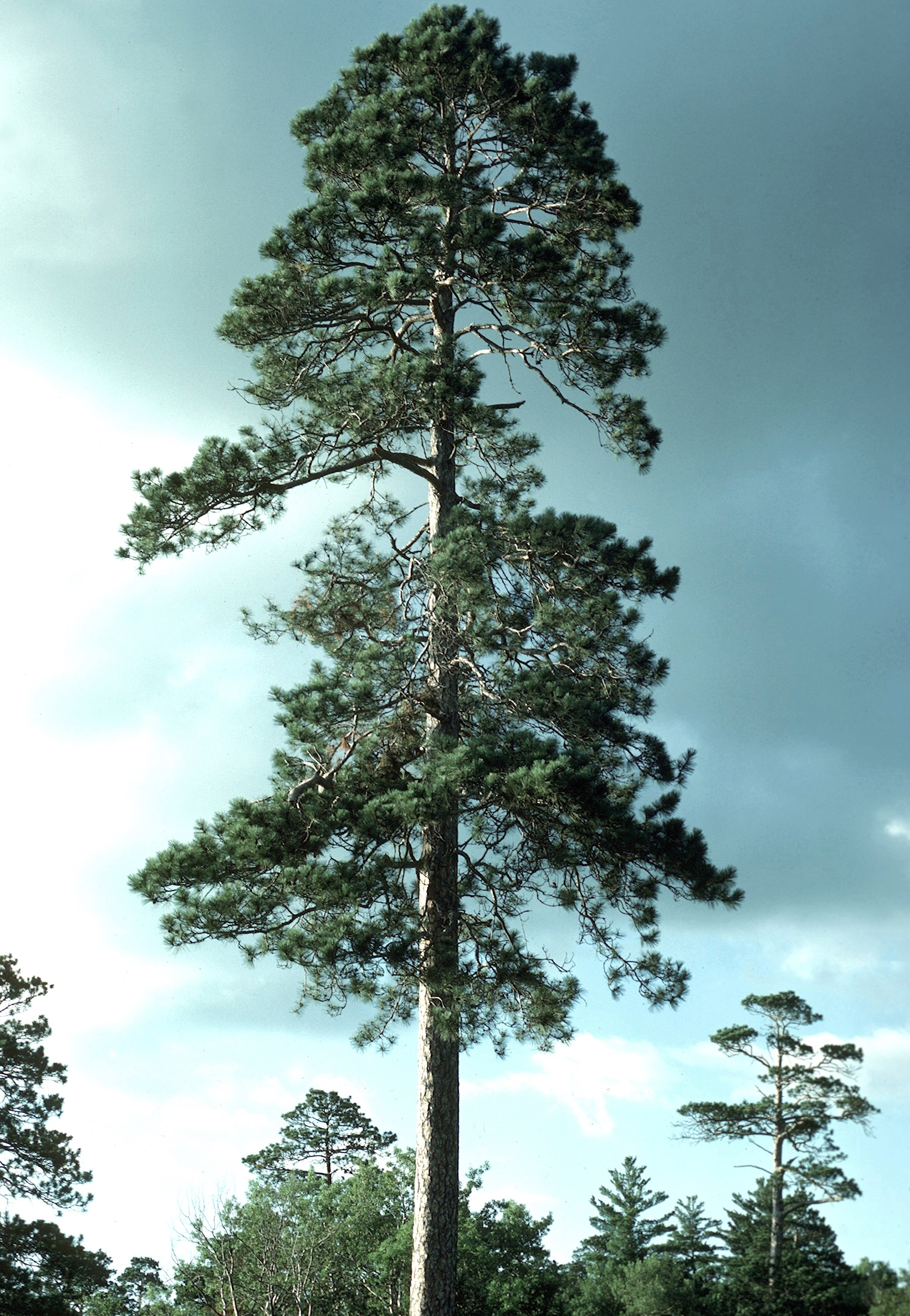
| | | | In the Heartwaters-Caretaker Woman sculpture, the Caretaker Woman is leaning over, releasing a clutch of small turtles from a basket. Her flowing hair is like flowing water. Her cupped hands are around a bowl representing Lake Itasca, with the life force of the headwaters spilling out of the bowl. | | | | The turtles are strong water symbols and the symbol of natural life. They represent the universal cycles of life in Ojibwe belief. The round shell of the turtle represents the seasonal cycles, and also the earth, moon, and sun, while the four legs point in the four cardinal directions. Turtles show us all directions of life, since they live in the water, walk on land, and breathe air. They are standing watch over the headwaters. | | | | The artist points out that caring for the waters is the sacred work of women, and explains that the Caretaker Woman's act represents the renewing of life, renewing of the seasons, and a continuation of the waters of life. | | | | Both the Caretaker Woman and the turtles are on a drumhead, which symbolizes the heartbeat of the Ojibwe Nation, as well as the heartbeat of the water that flows from the heartland of the continent. Hence it's the Heartwaters that the Caretaker Woman is overseeing at the headwaters of the Mississippi. | | | | In addition to Lake Itasca, the other thing the Park is known for, and for which it was also founded to help preserve, is the old-growth pine forest surrounding Lake Itasca. It's the most extensive stand of virgin timber left in the state, and one of the few places in the state that has preserved the ancient pines. It encompasses old-growth red pine and white pine. Actually, logging operations in the late 19C and early 20C—logging ended around 1920--depleted the large pine forests here, and, while pine restoration has been attempted dating back to 1902, there has been limited success. This is an old-growth red pine in the Park (Photo by Joseph O'Brien).
http://www.yellowmaps.com/usgs/topomaps/drg24/30p/p47095b2.jpg
| | | | To better see the pines, as well as Lake Itasca, we can take the 16 km (10 mi) Wilderness Drive around the North, West, and East Arms of the lake. Check the above US Geological Survey topographic map, and click to enlarge. Start at the top of the North Arm, at the Source. The road, like the lake, is also in three parts, and has a west, south, and east section. If you fail to see the west section on this map, neither can I. I checked, and this map is dated 1972, which has to explain why Beverly and I didn't take this drive on that first visit—part of the road wasn't built yet. | | | | The west and south sections are narrow and therefore one-way, so we have to drive counterclockwise around the lake. The west section is the best for seeing trees. This (apparently newer) road is narrow, about wide enough for a car-and-a-half, in case you want to pass. There are numerous wide spots to pull off, should you want to wander into the woods. There are also a lot of signs pointing to the oldest white pine here, the tallest red pine there, and the like. On a beautiful day like today, it's a great visit to the North Woods. | | | | As you can see, much of the south section doesn't border the lake, but the southwest corner is extremely interesting—and controversial. First take a look at Nicollet Creek, here misspelled with only one L. You can see how it drains Nicollet Lake, and then flows into Lake Itasca's West Arm. We stop here and take a look. We go a little further and also stop at Elk Lake, draining into Lake Itasca. Actually, a stream from Little Elk Lake further to the south first drains into Elk Lake as its longest tributary. Are we SURE Lake Itasca is the source of the Mississippi? | | | | Well, no one ever has been. If this were the Nile or the Amazon, any one of these tributaries might be considered the true source. In 1887, one Willard Glazier campaigned to considered Elk Lake, which he called Glazier Lake, to be considered the true source of the Mississippi. But from early on these claims were refuted, and even today, near Elk Lake there's a historic marker discussing the controversy and essentially dismissing it. In 1888-9, each lake and stream was checked out by Jacob V Brower, a land surveyor and president of the Minnesota Historical Society—the visitor center here is named for him. He spent five months exploring the area, and decided that Nicollet Creek flowed only intermittently and therefore shouldn't qualify as the source. This southern area was the watershed of Lake Itasca, and Nicollet Creek might qualify as the "infant Mississippi", but that "It was not until the waters flowed out of Lake Itasca that they united to form a true river". | | | | Believe what you will, but in any case, we covered all bases by visiting these locations on the Wilderness Drive—one of them has to be the source. And anyway, so much of this is show biz. The outflow at the North Arm of Lake Itasca is much more dramatic than here, and attracts loads of visitors, even though it's "landscaped nature". | | | | The rest of the south section of the road is still one way, but offers little new. The east section is two-way, because it's in the built-up area of the park, as all the little black dots indicate. They indicate the lodge, campgrounds, marinas. This sort of "wilderness" is of a much lower grade than we've been seeing, so the best of the drive is at the beginning. And so we return to the north entrance. As we leave the Park, let's take another look at this simpler map (Map by Matthew Trump) of the Itasca area (Nicollet is again misspelled, doubly this time) to review our perspective of all the factors involved in determining the source. | | | | Since we've come to the end of the Mississippi River part of this trip, we can now review what we've experienced via the music of Ferde Grofé, also spelled (and pronounced) Ferdie and short for Ferdinand von Grofé. He was born in New York City, of French Huguenot extraction, and from a family of classical musicians. He was both an arranger and composer, and his most memorable arrangement is that of George Gershwin's Rhapsody in Blue, where Grofé took what Gershwin had written for two pianos and arranged it for a full orchestra. | | | | I was only familiar with the one highly popular part of his Grand Canyon Suite when I found he also wrote a Mississippi Suite, and several others based on US landscapes. These are the ones I've found: Mississippi Suite (1925); Grand Canyon Suite (1931); Death Valley Suite (1949); Hudson River Suite (1955); Niagara Falls Suite (1960). | | | | I was also interested in seeing that the full name of the first one was "Mississippi Suite (Tone Journey)", although I'm sure it applies to all his suites based on landscapes. That seems to be a unique term, since normally, a piece of orchestral music that illustrates or evokes the content of a poem, painting, or landscape is referred to as a "tone poem" (or "symphonic poem"). The term seems to have been first used in German by Carl Loewe in 1828 as Tondichtung; later, Franz Liszt used it as Symphonische Dichtung. This genre of music, a direct consequence of Romanticism, is different from traditional classical symphonic movements in that this music is intended to inspire listeners to imagine scenes, images, or moods. Grofé's escalating the term "tone poem" to "tone journey" seems particularly appropriate to our travel themes where we visualize scenes, images, and moods. | | | | The Mississippi Suite (Tone Journey) is an orchestral suite in four movements depicting four scenes encountered between Lake Itasca and New Orleans. They're entitled: I Father of Waters (the river's birth in the Chippewa lands); II Huckleberry Finn (ruminating on Huck's prankish nature); III Old Creole Days (Grofé's interpretation of spirituals on plantations); IV Mardi Gras (celebrating in New Orleans). This YouTube video runs for 13:28: Mississippi Suite. It is nicely illustrated. The "art gallery" of paintings shown for much of it is alone worth this "journey". I hope you recognize the first picture you see as George Catlin's painting of St Anthony Falls. Several portraits of Native Americans that follow are also surely Catlin's. | | | | | | While the following doesn't really belong here, it's too much fun to leave out. Grofé's Grand Canyon Suite consists of I Sunrise; II Painted Desert; III On the Trail; IV Sunset; V Cloudburst. But it's the middle selection, On the Trail, that is probably the most popular piece he's written and is often found as a "single" on recordings or in concerts. It involves the guided mule ride one can take down the precipitous trail from the rim of the Grand Canyon to the bottom. The selection is notable for the music evoking the obvious rocking of the mule ride, and also gives a good impression of a sudden passing rainstorm. But the visual element of how this video was put together is a sight to see—note the credits at the end. This is Leonard Bernstein conducting the New York Philharmonic, and it runs 7:29 on Youtube: On the Trail.
[If you're really interested in the entire piece, also well illustrated, this is the complete Grand Canyon Suite with Bernstein and the NYPhil, running 33:08. For other suites I direct you to YouTube, where they are available.]
|
| | | | We leave Lake Itasca State Park and take the same countrified route back to Bemidji, peeking at the river again. We arrive the cozy, pedestrian-oriented downtown area with the statues, but then drive to our hotel in the north side of town, on a wide auto-oriented boulevard with large parking lots in front of shopping centers and strip malls. This is the way things look in the 20C-21C, with locations being easily drivable but not too pleasant visually. Still, the hotel is very nice and well situated for tomorrow. | | | | We are finished visiting the Mississippi, but as I mentioned earlier in the trip, we have a second side trip to take in addition to the one to Kansas City, this one further up north for just two nights. In the oddest of senses, it's very distantly Mississippi-related. More next time. | | | |
| |
|
|
|

