|
Reflections 2016
Series 6
April 20
Mississippi River XII: Minneapolis-2
| | Day 21: Minneapolis-2 On our second day in MSP it's time to get the car for a week's rental, Monday to Monday. I've arranged with Enterprise in St Paul for them to send someone to pick me up at the hotel to bring back to their office, and I phone them to confirm. Since I had 500 extra Enterprise points, although I couldn't get a free rental like in Dubuque—but that was only one day—I nevertheless got one day free in this rental.
http://www.lakesnwoods.com/images/Mendot44.jpg
| | | | I wanted to pick up the route at the river where we'd gotten off the AQ, so made my way to Sibley Street, past Union Depot, and turned right at Lambert Landing & Lower Landing Park down Shepard Road, which is part of the Great River Road. We go here right along the Mississippi, one of the few places you can do that for any distance at all, Elsah IL being another. As we start out, note on the map that there's a small part of St Paul to the south, on the west bank, so both cities are primarily on opposite banks from each other, but each having some territory on its non-principal bank. | | | | We pass Pike Island and the adjacent Sibley House (see map), and then get the view ahead, across the Mississippi, of Fort Snelling up on its bluff (Photo by AlexiusHoratius). An alternate view here shows the confluence (Photo by Bob Wesen), as seen from the south side. The Minnesota River is entering from the left, the Mississippi coming toward us and turning to our right. That's part of St Paul in the right background, with the Highway 5 bridge to Fort Snelling, which is hidden on the left. We are still on Shepard Road on the St Paul side, and it spirals up the bluff to join Highway 5 (see map) to cross the Mississippi to the Minneapolis side, leaving St Paul until we return in a week's time. | | | | Before we leave this map, note the X-shaped intersection at Fort Snelling which two bridges here form part of. We've used the NE spoke, to St Paul, coming over the bridge over the Mississippi, and will be using all three others today. The SE spoke goes over the Mendota Bridge to Mendota, a St Paul suburb. The SW spoke goes to the airport, and beyond to Richfield and Bloomington, Minneapolis suburbs. The NW spoke goes up to Minnehaha Falls and Minneapolis. Now discard that map and move to this detailed map of the same area, principally the X-shaped intersection ("the X map"):
http://mcaaconference.org/commonimg/map_3618_1.gif
| | | | Reorient yourself to Shepard Road joining Highway 5 to cross the Mississippi on the NE St Paul spoke. Now for a little "stunt", we're going to use the SE spoke, which is Highway 55 crossing the Mendota Bridge over the Minnesota River. We go just a little bit into Mendota, then find a spot to turn around. And from here, this is what we can see:
http://stmedia.startribune.com/images/ows_1366136420231.jpg
https://sdate.files.wordpress.com/2010/08/bike_1_st-paul-skyline.jpg
| | | | The first view is back over the Mendota Bridge we just crossed. The Minnesota River is below, and, since you can't see any water down below, you already have an idea of the height of the bluffs here. Right of center is Fort Snelling on the opposite side, and you can see its gray Round Tower, part of its fortifications. But the spectacle is the Minneapolis skyline in the distance. I assume the dark black building is the IDS Tower, now the tallest in MN, and good luck spotting the Foshay Tower—I can't. But do realize that years ago, it would have stood out as the only show in town. From roughly the same spot, here's the little "stunt": we turn 90° to the right and can see the St Paul skyline in the second picture. I don't know of any other place you can see both skylines so easily from the same spot. | | | | We return over the Mendota Bridge, but before visiting Fort Snelling and Minnehaha Falls, I need to take a personal detour, a second sentimental journey after the Foshay Tower, for a few hours down the SW spoke, past the airport, to Bloomington. For this, we go back to this larger MSP map from the last posting:
http://www.minnesotamonthly.com/Guides-Resources/Maps/Where-Twin-Cities-Maps/2012-Where-Map-Metropolitan-Area.jpg
| | | | Find our X-intersection on this map and follow Highway 5, I-494, and I-35W to 98th Street in Bloomington, where Beverly was from, and let's inspect some geography. Both Richfield and Bloomington are separate municipalities from Minneapolis, although suburbs of it. Still, more than other places I feel, they function as extensions of Minneapolis. Note how downtown N-S Minneapolis streets such as Nicollet, Lyndale, Penn, and many others run right through Richfield and Bloomington to the Minnesota River. And even more strikingly, the E-W numbered streets continue to the river as well: Minneapolis runs from the low numbers we saw downtown to roughly 62nd Street, Richfield runs from there to about 78th Street (and nowadays, I-494), and Bloomington continues to roughly 112th Street near the Minnesota River. | | | | In addition, neither Richfield nor Bloomington have a downtown core in the traditional sense that MSP and other cities have. There were small settlements made by early arrivals (Bloomington is named after Bloomington, Illinois), such as Oxboro on 98th Street, but as the area grew, while remaining separate municipalities, de facto, both are extensions of Minneapolis. Someone from Bloomington would probably tell locals that's where they were from, but would tell outsiders they're from Minneapolis, which is what Beverly told me when we met at Middlebury. With streets extending from Minneapolis, there certainly would be no reason to say they're from St Paul. | | | | Anyway, the quick sentimental journey in Bloomington involves taking a quick look at the shopping area we used so often on our visits in the former Oxboro on 98th Street, driving down past the church where we got married in 1962, and driving out to the cemetery where my in-laws are buried to pay my respects, since I was not able to attend my mother-in-law's funeral in 2011. | | | | But the best part was visiting friends on the "old street". Find Penn Avenue between 98th and its end at 102nd. To its immediate left is a stream, Nine Mile Creek. To the immediate left of that is Brookside Avenue, not shown, which runs these same four blocks, with Beverly's family having lived right off 98th. Literally across the street are family neighbors and close friends LaVonne and Al, who I've known since the wedding in 1962, which they attended. LaVonne remains as a website subscriber and occasional correspondent, and I emailed her in advance saying I'd like to stop by that morning. Gracious as ever, she invited me to lunch, and told me she'd also invite Gloria, who now lives in my mother-in-law's house. LaVonne checked with Gloria, and we could have a house tour after lunch. | | | | It was superb. LaVonne served an outstanding lunch, and the conversation was great. LaVonne knows a lot about Brookside Avenue—and so do I after 53 years of visits—so I joked that we two should become local historians. Gloria has traveled, and taught at a local college. After a delightful lunch, we all went across the street and Gloria showed me how nicely she's improved the house, including connecting kitchen and dining room, and building a deck outside the dining room. It was a great sentimental journey, and I'm glad I took the time to do it. | | | | | | As an aside, I'll include a family story I "inherited". The whole family was Swedish-American, but while my mother-in-law was born in (northern) Minnesota, my father-in-law was an immigrant who crossed the Atlantic alone at age 16. While we picture Sweden today as a prosperous country, the reason there was so much Scandinavian immigration was that there was a lot of poverty at the turn of the 20C. In any case, my father-in-law brought many "old country" ways with him. What comes to mind now is that Beverly had been born in Minneapolis, where the family lived. In 1943, her father began to fret about what could happen with the war, and he decided everyone should be able to grow their own food. (He'd grown up on a small farm named Stenslund, which is where Beverly and I got engaged the Christmas of our Mainz year.) Thinking about the war, he uprooted the family from Minneapolis and moved them to then rural Brookside Avenue in Bloomington. Their original house lot was large, they did grow their own vegetables, and I believe Beverly said they once kept a cow in the garage. It was this sort of "history" I had between 1943, my arrival in 1962 and the following years, and this visit in 2015 that gives me this perspective on the neighborhood. |
| | | | Back to Fort Snelling and the X-map. We return past the airport and see the more active part of Fort Snelling, in brown, is now for the army reserve, while Historic Fort Snelling remains by the rivers. We start out on the NW spoke to visit the fort, and will continue on it later through that bit of Richfield in white to Minnehaha Falls and Minneapolis. You can discard this map now, as we'll have other detailed maps from here to Minneapolis:
https://www.nps.gov/common/uploads/photogallery/mwr/park/miss/A3C5E17A-155D-4519-3E6B3C5502A09919/A3C5E17A-155D-4519-3E6B3C5502A09919-large.jpg
http://www.historicfortsnelling.org/web_assets/hfs/HFS_siteGuide_updated.jpg
| | | | Fort Snelling In this aerial view, you should by now be able to recognize our X-intersection and see that our area of interest, the Fort Snelling National Historic Landmark (NHL), run by the Minnesota Historical Society (MHS), is near the river. Actually, let's refine that. You can see that the bridge from St Paul cuts through the area in a tunnel so as not to disturb it. All the buildings to the left are of less interest, the Visitor Center, where we enter the site, is for those who don't know the history, and some older outbuildings in the process of being restored. We have to continue to drive over that tunnel on that white road to the front gate in order to reach what is described here so enticingly as the "Frontier Fort". Well, I suppose that's what it is.
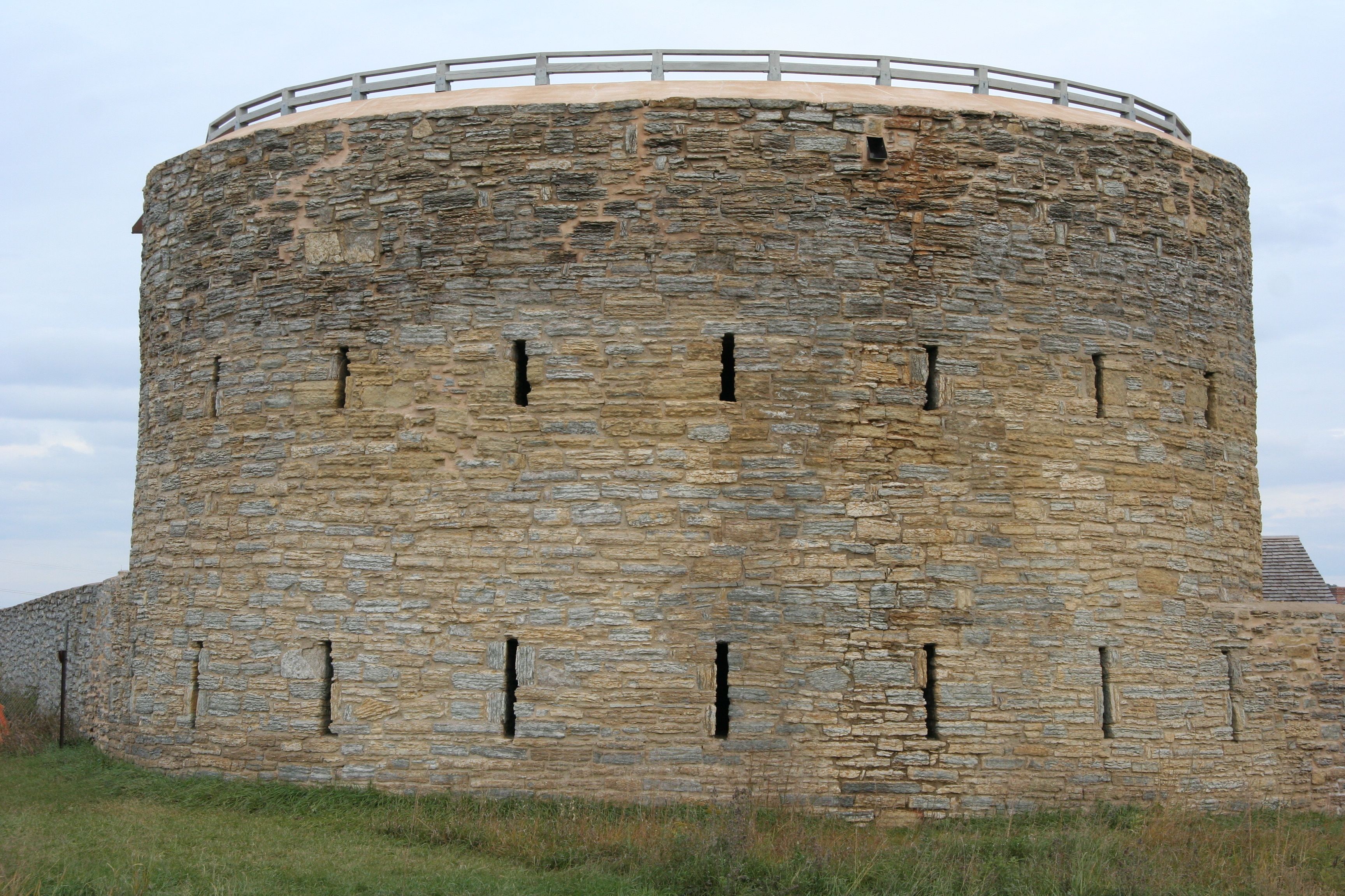
| | | | The second link is to a sketch that shows that front gate along with the famous Round Tower on the left. At this time of the year, the Fort is open only on Saturdays, so it's closed today. In any case, I've visited it in the past, where there are historic reenactors to give a flavor of the past. I remember when Beverly and I were talking to a costumed "frontiersman" who remained in character—and we played along--and was explaining how he'd just gotten back from hunting—or maybe fur trapping. It's a nice touch. | | | | The Round Tower (Photo by Jonathunder) is the oldest, and most iconic, part of Fort Snelling. As the sketch shows, it's just down the outside wall from the front gate (Photo by Ben Franske). This is the view from the Round Tower over the interior grounds (Photo by The Statue With The Dictionary). Once again, the bluffs are beyond, and you are looking across the rivers, without seeing them, to the other side. To see water, you have to go to the retaining wall and look down, but this view up the Mississippi toward Minneapolis should give an idea of the look of the beginning of the Mississippi Gorge here at its south end. Be sure to click to see the skyline. (If you want another smile, look at this closeup from the south (Photo by steve lyon), then click to find the Foshay Tower among its taller brothers.
| | | | Minnehaha Falls/Creek/Park: Orientation From the Fort we continue north to Minnehaha Falls. Use this map, our "Minnehaha map"—it's for bikes, but suits our needs--and click to enlarge:
http://1.bp.blogspot.com/-m2BlbsXbD9g/UiS5vkcHcpI/AAAAAAAAEEQ/258Ju9m5Weo/s1600/BikeMap%2312MinneapolisSEMinnehahaDetail270574.tiff
| | | | At the bottom, you see how Minneapolis peters out even earlier than 60th Street at this point in favor of Richfield and the airport. From our X-intersection at the Fort you see how much parkland there is here along the Mississippi River Gorge. Our NW spoke becomes Highway 55, then Hiawatha Avenue, which runs, mostly straight as an arrow, to downtown Minneapolis. (Fear not, there's also a Minnehaha Avenue snuggling alongside it on one side or the other most of the way.) But I present my street-grid challenge again about streets showing history: if the street grid is so N-S/E-W oriented, how do you explain the angular Hiawatha Avenue? | | | | Usually, there are two explanations. One is that it was a country road predating the street grid, which is the explanation for Broadway in New York City. The other is that it was a rail line doing the same. I've always thought this situation was just the rail line, but on reflection, it could also have been a country road predating even the rail line, given how it connects the Fort, the Falls, and downtown. | | | | But as we drive up Hiawatha Avenue, we find that (light) rail is not far behind. We see the Blue Line coming up from Bloomington, on this map still using its older name Hiawatha Line, so you see the basis for that name. Sure enough, there's a station for Fort Snelling, and the 50th Street station serves Minnehaha Park, showing again that, the more things change, the more they remain the same. | | | | We're now going to concentrate on the main part of the park, in the north. On the left, we see Minnehaha Creek coming all the way from large Lake Minnetonka in the west. Minnehaha Parkway runs along it for much of the way, although here at its end, they're slightly separated. To explain the notation "Grand Rounds", take a quick look at these two links:
http://www.fhwa.dot.gov/byways/Uploads/static_maps/000/000/352/MN_GrandRounds.gif
http://50.59.38.231/grandrounds/images-map/map_M1.gif
| | | | The Grand Rounds National Scenic Byway (first link) is a linked series of park areas in Minneapolis that, roughly, encircles the city for about 80 km (50 mi). The roadways are meant for pedestrians, bikes, and cars. Much of it was build by the Civilian Conservation Corps (CCC) in the 1930s. The first map shows in dark red how it connects lakes, the Falls area, and the Mississippi, where it's part of the Great River Road (other GRR sections are in light red). The second link shows the Minnehaha Byway, in the Creek/Park/Falls area we're in now. You can see better how Minnehaha Parkway follows the Creek partially, but not entirely. Let's return to our main Minnehaha map. | | | | Across the river, you see the Ford Assembly plant. It's for that reason that everybody calls the aptly-named Intercity Bridge you see the Ford Bridge, and Mississippi Lock & Dam #1, which we'll visit shortly, the Ford Dam. Notice how the Minnesota Veterans Home is poorly placed, surrounded by the park. I suppose it's nice the vets have nice views, but it seems to just block views for others. It's hard to tell on this map just where the Falls are, and hard to see how the Creek flows south of the Home, so we have this map, which has the great advantage of also showing elevations:
https://www.topoquest.com/place-detail-map.php?id=647924
| | | | You see how Minnehaha Creek, once it crosses under Hiawatha Avenue soon reaches a gorge and drops into it as Minnehaha Falls. It then turns southeast in its gorge, past the Home, and into the Mississippi. In the past, I've hiked this short gorge from the Falls to the River, which runs about 1.2 km (0.75 mi). In any case, Minnehaha Falls can NOT be seen from the Mississippi. | | | | This little elevation drawing finally shows me just where it was that I went hiking. But two interesting points can be raised. First, it's a definite fact that, 10,000 years ago, Minnehaha Falls were located on the bluffs, right at the Mississippi, and, over time, the Falls have eaten away at the rock, ever moving backwards, creating its own gorge, and hiding itself inland. This is exactly what the Niagara River did as Niagara Falls created Niagara Gorge. | | | | The second point is one to which I have no answer, just a question for all to ponder. The Minnehaha Gorge is Y-shaped. Why? (No pun intended.) The northern part of the fork had to have been created by water. There is no other creek here. My (unproven) hypothesis is that, although the Creek enters the Gorge from the west today, perhaps the very same creek once entered from the north. Try and find a better explanation. | | | | Minnehaha Falls: Becoming a Travel Destination Minnehaha Falls, of course, were known from the early Fort Snelling days, since they were on the road to St Anthony Falls. At first, they got the name Brown's Falls, but later returned to their original Native American name. No industry ever came to Minnehaha Falls, since the mills at St Anthony Falls economically overshadowed any commercial potential their waterpower may have otherwise had. Thus, they were never urbanized, and became part of Minnehaha Park when it was designed in 1883 as part of the Grand Rounds Scenic Byway. | | | | The first name we'll mention of people who attracted travelers to the Upper Mississippi and Minnehaha Falls area is Giacomo Beltrami, an Italian author and explorer. He was a passenger on the maiden voyage of the Virginia in 1823, which was the first steamboat to come up the Upper Mississippi. At the time, Fort Snelling was still called Fort St Anthony. He compared the wonders of the river bluffs and wooded hillsides he saw with the scenery of the Rhine. (Well, maybe, maybe not. The Rhine can be really spectacular.) He went beyond to the north and claimed he found the source of the Mississippi. (He did not.) In memory of a good friend he'd lost in Italy, Giulia Spada dei Medici, he named the lake he thought was the source Lago Giulia, which today is Lake Julia, north of Bemidji. We'll be in Bemidji in three days, when we visit the real source, Lake Itasca, southwest of Bemidji. In any case, today Bemidji is the county seat of Beltrami County. | | | | The real turnaround that brought attention to the area involved George Catlin, the famous American painter, author, and traveler who specialized in portraits of Native Americans of the Old West, and who therefore became quite knowledgeable of the western frontier. He established himself in St Louis as a base of operations, and between 1830 and 1836 made five journeys to visit the Old West. On the 1830 trip, he accompanied none other than William Clark (of Lewis & Clark), who was on a diplomatic mission up the Mississippi into Native American territory. All in all, Catlin eventually visited 50 tribes to increase his knowledge and for subjects for his portraiture. | | | | In any case, as more and more steamboats began coming up to Minnesota, in 1835, Catlin arrived from St Louis to visit Fort Snelling and St Anthony Falls (we'll show his Falls painting below). Catlin was impressed with the scenery he found, and in his writings proposed a "Fashionable Tour" of the Upper Mississippi, writing "I leave it for the world to come and gaze upon [it] for themselves." He suggested a trip "by steamer to Rock Island [in today's Quad Cities], Galena [ha!], Dubuque, Prairie du Chien [in WI, between Dubuque and LaCrosse], Lake Pepin, . . . Fall of St Anthony". Thus Catlin was the traveler who was the impetus for visitors to come to this area, and also the basis for the slogan-like name of the trip. | | | | The idea of such a trip spread quickly, with numbers of visitors increasing rapidly. Most visitors in the earlier years were men, but there were some women who would hazard a trip to the outposts of the US. One of them, a vivacious lady of 80, was Elizabeth Schuyler Hamilton, the widow of Alexander Hamilton. She arrived on the steamboat Burlington, and visited Minnehaha Falls, St Anthony Falls, and Fort Snelling, where the officers of the fort accorded her a royal reception, as befitted a queen of fashion. Thus the Fashionable Tour was stamped with the approval of the celebrated lady. | | | | Sightseers, artists, and photographers than began to arrive for the tour singly, in honeymoon couples, in small groups, and even in large groups in parties of hundreds. Sometimes the steamboat companies wised up and offered their own tours of the area, once they had brought the people there. Package tours were offered from places as far away as New Orleans and Pittsburgh, and some steamboats began to limit themselves only to excursionists who wanted to make the tour. As the fame of the tour spread, by the mid-1840s, visitors from New York, Washington, Pittsburgh, Cincinnati, New Orleans, St Louis, and Galena were making the trip, and spreading the word of what was to be seen and done in the area of Fort Snelling. | | | | So just what was the tour? Passengers disembarked either at a landing in St Paul, or in Minneapolis. [Remember, landings are for commerce. If Minneapolis didn't have one, steamboats have those antenna-like gangways upfront called "stages", hanging from winches that can drop passengers on a riverbank or concrete levee, which is what happened to us on the AQ in Vicksburg and elsewhere.] Leaving from St Paul, passengers went by stagecoach to St Anthony, then out to Lakes Calhoun and Harriet (see Grand Rounds map above), then to Minnehaha Falls and Fort Snelling, then back to St Paul, where, if this were a day trip, they could even catch their steamboat to leave. | | | | Later, another option evolved. The Rock Island Railroad was the first to reach the Mississippi, from Chicago to Rock Island (Quad Cities), in 1854. There was a special celebration at that time to commemorate this union of rail 'n' sail. It included a voyage of 1200 people-- ex-President Millard Fillmore was among them--in seven chartered steamboats to St Paul for the Tour. | | | | By the 1870s, the railroads had arrived completely and one could go all the way from the East to MSP by rail, extending the Fashionable Tour to thousands more. In 1878, the Chicago, Burlington & Quincy railway published a promotional booklet, A Guide to the Summer Resorts of Minnesota. It describes the pleasant ride by carriage from Minneapolis via Minnehaha Falls to St Paul. The round trip from St Louis to Minneapolis, which featured Pullman sleeping cars, was $30. | | | | But with the decline of the steamboats in the face of competition from the railroads, the day of the Fashionable Tour passed as well. Local excursions continued to be popular, but the great, gala excursions by steamboat were gone. | | | | Minnehaha Falls had also attracted artists and photographers (see "Hesler" below). In the previous posting, we saw that German-American artist Albert Bierstadt of the Hudson Valley School had painted St Anthony falls in the 1880s. He also left us with a beautiful painting of Minnehaha Falls (click). Its date is unknown, but could logically be from the same period. | | | | Minnehaha Falls: Longfellow & Minnehaha Now we've moved ahead into the railroad period of the 1880s, but we need to go back to the height of the steamboat period in the 1850s. The Tour, including Minnehaha Falls, was also at its height. 1852 was when Charles Hoag named Minneapolis. Since Longfellow and his characters weren't involved yet, we can see he wanted his "Minnehaha City" named directly after Minnehaha Falls. | | | | So where does Longfellow come in? And how and why? He'd been interviewing Native American chiefs to get an idea of their legends, although Longfellow's Song of Hiawatha would be a highly romanticized version of whatever he might have learned. But he needed a name for Hiawatha's lover. He certainly knew of Minnehaha Falls because of its nationwide fame because of the Tour, and he'd read what some local writers had written about it. But what convinced him to use the name of the Falls for his character? After all, Longfellow never visited the Falls himself. | | | | I always picture photography as being newer than it is, even though Matthew Brady's Civil War photographs of the 1860s are so well known. But photography is older than that, and in the 1850s, Alexander Hesler was an award-winning photographer working in Illinois, principally Chicago. Hesler is most famous for his photographic portraits in 1858 and 1860 of Lincoln. This is an 1860 photograph of a 51-year-old, beardless Abraham Lincoln, located today in the, Museum of Fine Arts in Boston. This was among those used in the 1860 political campaign. | | | | But in 1851, Hesler, probably on the Tour, visited Minnesota and made this daguerrotype of Minnehaha Falls. When this photograph reached Longfellow's attention, it convinced him, along with what he'd read, to name his character Minnehaha in the epic poem published in 1855. As well-known as Minnehaha Falls had been domestically, Longfellow using the name in a literary context brought the name world-wide fame. | | | | Minnehaha Falls: Visit So now we have sufficient ammunition to visit Minnehaha Falls, so let's go back to our main "Minnehaha map". The park is a historic district, and we have three buildings to start with, a blandly trivial one, a historic one, and an absolutely charming one. They are all in easy walking distance of each other, and of the Falls. | | | | Look at the very end of Minnehaha Parkway, just before the traffic circle. In Longfellow Gardens is the Longfellow House. Because of this location it's been moved to, it's easily spotted when driving by. But don't get excited--as we said, Longfellow was never here. A Minneapolis businessman was an admirer of Longfellow, and had a residence built for himself, which was later moved to this location. The house was a 2/3-scale replica of Longfellow's home in Cambridge, Massachusetts (Photo by William Wesen). It looks nice enough, and does serve as a park administration office and information center, but is really a triviality. | | | | On the map, move south to the Depot, and across the road from it, in the park, is the John H Stevens House. We've talked about him before, and there's a lot of history here. In 1852, when Charles Hoag came up with the name Minnehapolis, with an H, and George Bowman, the editor of the St Anthony Express, published it across the river, they then presented it to Stevens at a meeting, and it was accepted. The Stevens House (Photo by McGhiever) had had three locations in town, the first two near the river, just east of Nicollet Avenue, the third further east. It was moved to the park in 1896. What's its importance otherwise? It was the first authorized house, built in 1850, on the west bank of the Mississippi where Minneapolis would develop. He was allowed to build by Fort Snelling because he provided ferry service to the former St Anthony. But in the following five years, the Stevens house became a community center, a hub of civic and social activity, and has been called the "birthplace of Minneapolis". Hennepin County was organized here. Minneapolis was organized here. And, as we saw, this is where Hoag had his name for the town formalized—without the H. The house would still have been by the river in 1852, and, since Hoag intended for Minneapolis to be "Minnehaha City", it's particularly appropriate that, when a new location for the Stevens house was being sought, a location steps from Minnehaha Falls should have been chosen. It just seems so right. But how many people get the reference? | | | | Now for the charm. Turn around and look back at the Minnehaha Depot we just referenced. It's located right on the straightaway of Hiawatha Avenue, between it and Minnehaha Avenue, here called Minnehaha Park Drive. We've said this route was a country road, then rail line, and this remains proof of that. It was a stop on the Milwaukee Road railroad and connected downtown Minneapolis, the Park, Fort Snelling, and St Paul, a route that we know because of the Fashionable Tour. On summer weekends in the early 20C, the Depot handled as many as 39 round trips per day. At other times, it was integrated into the region's streetcar system. While all that is gone, it's so ironic that we've spent money to build it back up, since the 50th Street/Minnehaha Park station of the Blue Line is just steps away (see map). | | | | So where's the charm? While the official name of the very petite building is the Minnehaha Depot, it's usually referred to as the Princess Depot (Photo by William Wesen). Note that the track is symbolic. The Depot was built in 1875 in the Carpenter Gothic style, which we discussed extensively in 2011/18 on the visit to Martha's Vineyard, which also included a discussion of the house in Grant Wood's iconic painting American Gothic. This is a tight condensation of the beginning of that discussion: Carpenter Gothic is a manifestation of the Gothic Revival movement that intensified in the late 19C . . . The majority of structures were wooden, and were often both designed and built by house carpenters. The style improvises on features prevalent in authentic Gothic architecture that had been carved in stone, but applied here to wood, with a picturesque result. . . . [T]he style in its improvisation emphasized charm and quaintness . . . Typical of the decoration is the filigree woodwork, characterized by moldings with a profusion of sawn details, known as gingerbread . . . | | | | The Minnehaha "Princess" Depot is owned by the Minnesota Historical Society and run by the Minnesota Transportation Museum. As such, it's only open summer Sunday afternoons, so Beverly and I went out of our way some years ago to visit it and the Stevens House. The interior of the Depot is complete and well-preserved. It has a ticket window, waiting room benches, and a pot-belly stove. The only decent pictures I can find of the interior are in this link to the Hennepin County Library:
http://hclib.tumblr.com/post/55443827259/minnehaha-princess-depot-built-in-1875-and
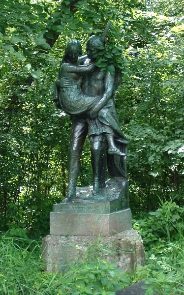
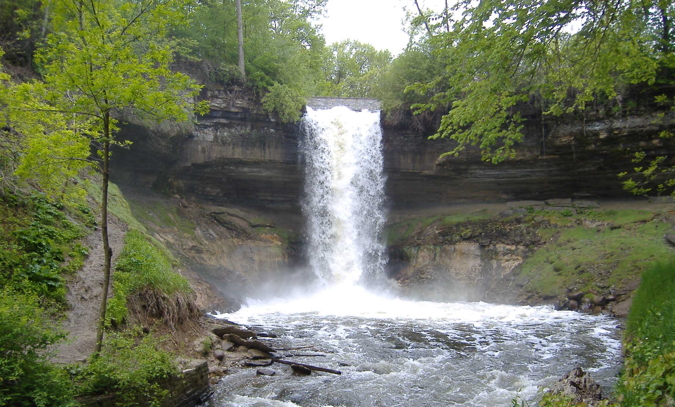
| | | | Steps into the park, we finally come to Minnehaha Falls. At the creek, the first thing we see, just before the actual falls, is the iconic statue of Hiawatha carrying Minnehaha (Photo by Mulad) as they're about to cross Minnehaha Creek. Just a bit further downstream is a bridge over the top of the falls. It's an impressive view to stand on the bridge and see the water shooting out from under you and over the Falls (Photo by Yinan Chen). Click to look beyond the furious water to see spectators at the bridge at the bottom. When we get down there, we see the iconic front view of the 16 m (53 ft) Minnehaha Falls (Photo by The Statue With The Dictionary). Click to move in closer and note the bridge at the top we were just at. You'll also see the walkway behind the falls, though I've never been there. Finally, this short (0:32) YouTube video shows a combination of both views. It's taken from up top, just down a bit from that bridge, yet the side view shows the whole waterfall.
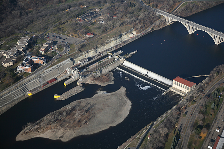
| | | | In the winter, there's always some freezing here, which I've seen in the past, and sometimes the falls freeze solid, which I don't recall ever seeing. This picture shows both the walkway behind, and the frozen falls (Photo by Albert Leung). | | | | Mississippi River Gorge The Gorge of the Mississippi is unique, as there's no other place on the river that has one. It runs from Fort Snelling almost to downtown Minneapolis, but the northern portion, above the Park, is better known, and is part of the Grand Rounds. But as we take Godfrey Parkway to drive out of the Park to go upstream—we'll find out later who Ard Godfrey was--we come across an unplanned diversion, and take it. It's a little riverside road that dips down under the Ford Bridge and brings us to a viewing area next to Lock & Dam #1, known informally as the Ford Dam (see map). This aerial view of the area shows it nicely. While Minnehaha Falls are hidden in the trees, the MN Veterans Home stands out on the riverside, as does the Ford Bridge. You can see the road we just drove down, and the white river bluffs that are now to our side as we stop to view the lock area and dam. While the locks are government property, the dam is private, originally built by the Ford Assembly Plant on the St Paul side as a hydroelectric generating station, and later sold to another private entity.
| | | | Actually, it's a double lock, so it can accommodate two-way traffic more easily, yet the two locks together are the same width as the next single lock downstream. The locks were completed in 1932 and allowed river access to the lower end of St Anthony Falls upriver in Minneapolis. Additional locks were added there in the 1960s extending the head of navigation to the northern part of the city. However, a dam in Coon Rapids (which we'll pass tomorrow), has no lock, and prevents travel any farther north. North of Coon Rapids, the Headwaters area also has power-generating dams, but no locks, meaning the parts of the river between the locks are just de facto lakes for pleasure boating. | | | | This is a view of the double lock and dam from the Minneapolis side, with the Ford plant in the distance, and this next panoramic view is from the St Paul side (Photo by F4fluids). Click to scan the view, and note again in particular the white limestone of the river bluffs on the other side to the right, so you can get an idea of the height of the gorge.
http://50.59.38.231/grandrounds/images-map/map_MR1.gif
| | | | As move up the gorge, we find we're in the next section of the Grand Rounds, the last one before Downtown Minneapolis. There are attractive river roads on both sides now. We're on West River Parkway, which has a matching East River Parkway on Minneapolis's part of the east bank; in St Paul it's called Mississippi River Boulevard.
http://paddletaxi.org/wp-content/uploads/2013/07/mississippigorgel.jpg
| | | | The fine autumnal weather continues up the Mississippi River Gorge, where the river has cut its way into the underlying stone. The Gorge runs for about 13 km (8 mi) from Fort Snelling almost to downtown Minneapolis, although the Grand Rounds starts at Minnehaha Park. The bluffs are about 15-30 m (50-100 ft) high, with the tops across the river being about 160-320 m (500-100 ft) apart. But most interesting is the river bottom. We saw the diagram of how the river bottom rises coming north, particularly as it reaches St Paul, but then said the stretch to Minneapolis rises dramatically beyond that. It's the Gorge that makes the difference, since north to south, the river bottom drops some 33.5 m (110 ft) in that rather short distance. It's the steepest stretch of the entire river. The nature of the gorge has changed dramatically with the construction of the dams. Before the dams, in times of high water, rapids raged down the gorge. In times of low water, giant boulders emerged creating more than a dozen islands, of which only one remains today. | | | | As we approach downtown, we come to the two campuses of the University of Minnesota (see map), reflected in the two stops we discussed on the Green Line, the East Bank (Campus) and the West Bank (Campus). We also come to some flat park land along the river, which offers rare opportunity in town to access the river below the 8 m (25 ft) limestone bluffs. One is East River Flats Park, indicated on our map by a picnic table south of the East Campus. The other, where we make a quick stop, is
Bohemian Flats Park (Photo by Mulad), formerly inhabited by Eastern European immigrants, which is located around the bend, below the West Campus at the Washington Avenue Bridge. This view shows both the bridge and East Campus on the limestone bluffs. The bluffs on the west bank are behind us. The upper deck is for pedestrians and bicycles between campuses, the lower deck now has one car lane in each direction and—surprise!—the Green Line between them.
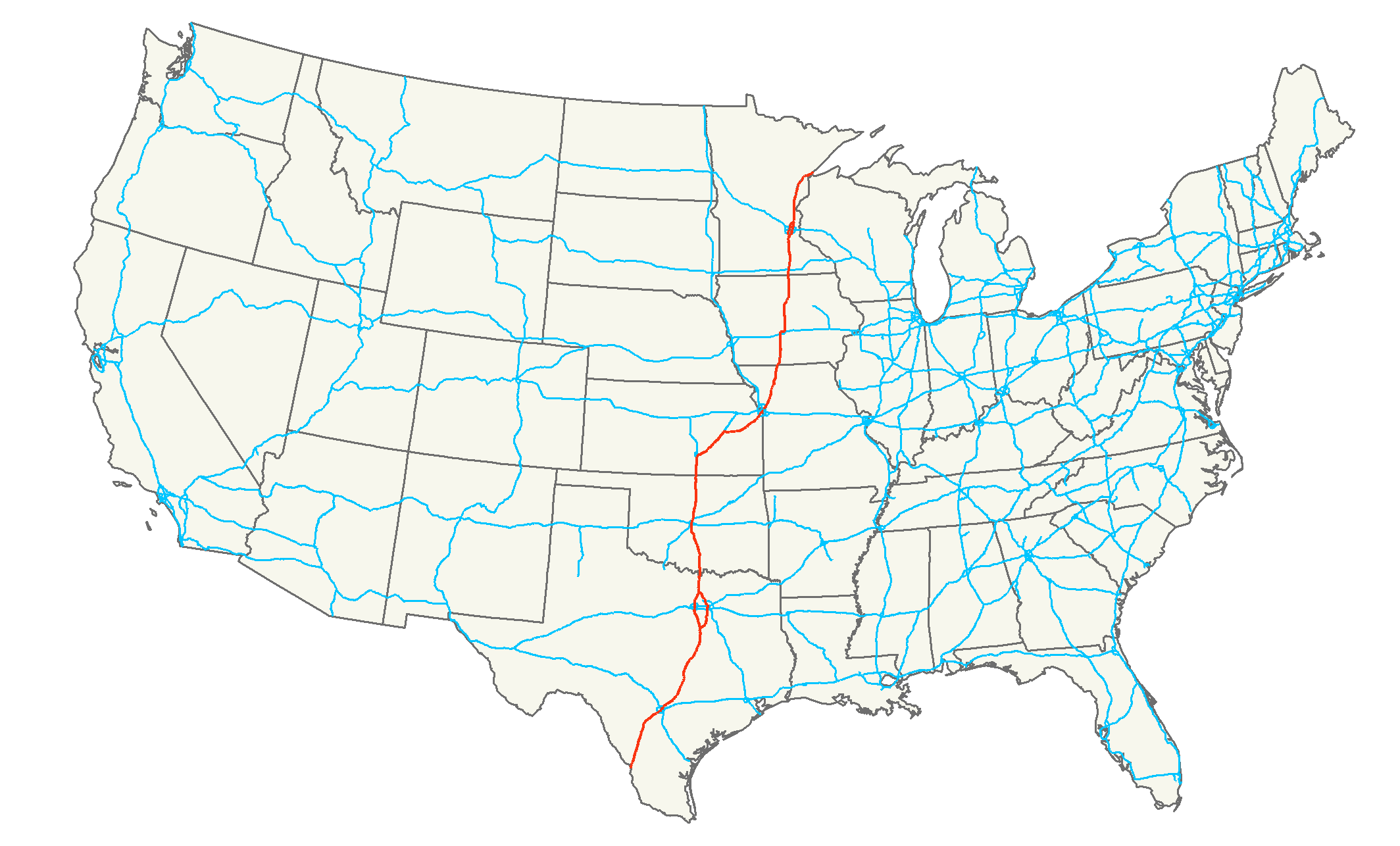
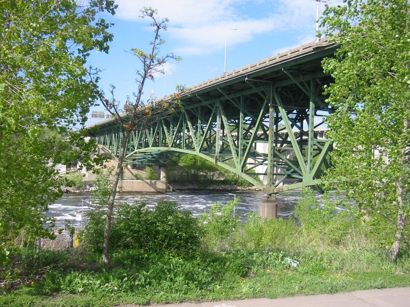
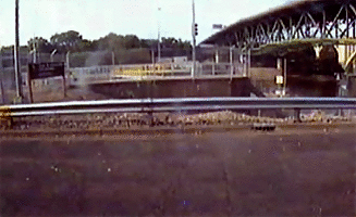
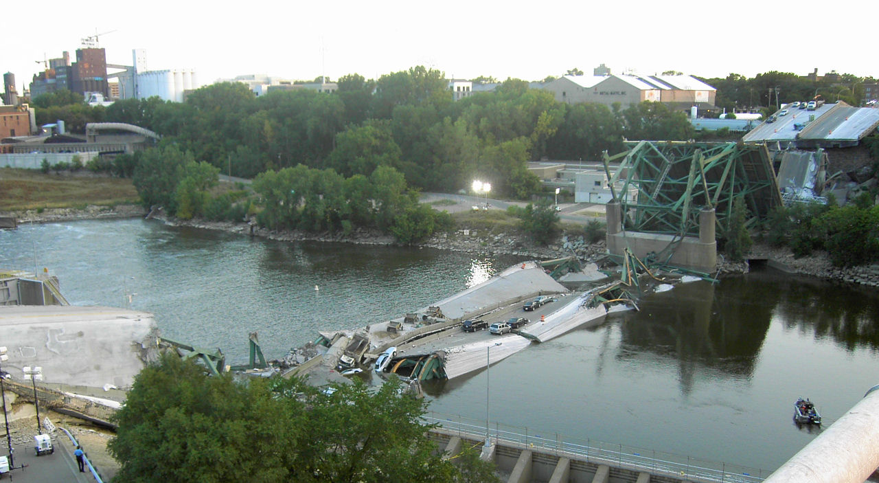
| | | | As it turns out, though we're going to do a clockwise loop downtown, a section of West River Parkway is under construction, so we need a minor detour, and drive across the Washington Avenue Bridge, meaning we crossed this bridge by streetcar yesterday and by car today. We do a quick drive-thru of the East Bank Campus, as shown here (Map by Rfc1394). You see the closed parkway section between the Washington Avenue Bridge and our return route, the 10th Avenue Bridge. It used to be called the Cedar Avenue Bridge to which it used to connect, but since the construction of the interstate, it connects with 19th Avenue S. | | | | As we make our way on east bank streets, we come very close to our hotel for tonight, the aptly named University Inn located at the northwest corner of 10th Avenue SE and 4th Street SE. But there's no time now to stop so over the 10th Avenue Bridge we go, and back onto (1) West River Parkway (Photo by Bolobilly), clearly seen (click) on the left. | | | | It's also a beautiful panorama of (2) downtown Minneapolis, so let's play "Find the Foshay". (You can see its gray pyramid roof to the left of an aqua building.) You can see (3) the yellow "Gold Medal Flour" sign marking the Mill City Museum in the Mill Ruins Park. Peeking under the bridge you get an early preview of the (4) Stone Arch Bridge, and, closer still, (5) what is considered the Lower St Anthony Falls, actually the Lower St Anthony Lock (left) & Dam (right). Also noteworthy, then, is that the 10th Avenue Bridge marks the downstream limit of the St Anthony Falls Historic District. | | | | I had to check the date this photo was taken, which is 2006, and significant. The lesser issue is that it shows on the left the white fiberglass fabric roof of the (6) Metrodome, which was demolished in 2014. Much more to the point is that you can also see under the bridge the green trusses of (7) the I-35W Bridge that disappeared suddenly in 2007. | | | | The I-35W Bridge Collapse Let's first review the highway, which we last saw in Dallas, where we noted that I-35 (Map by Nick Nolte), which runs between the Mexican border and Duluth, splits in two places into west and east segments. Through Fort Worth runs I-35 W, and through Dallas runs I-35E, of which we used a small segment. The same thing happens in MSP. If you look at our St Paul map in 2015/5, you'll see that the interstate going through town is called I-35E. Similarly (see map), going through Minneapolis here is I-35W. | | | | The original bridge carrying it over the Mississippi between the two parts of Minneapolis was opened to traffic in 1967. It was an eight-lane steel truss arch bridge. During the evening rush hour on 1 August 2007, it suddenly collapsed into the river, killing 13 and injuring 145. It had been the fifth busiest bridge in Minnesota, carrying 140,000 vehicles a day. It was determined that the collapse was caused by a design flaw involving a plate that was too thin. The extra weight of additional rush-hour traffic was then apparently too much. This is an aerial view in 2004 of the area. Click to inspect, from left to right along the West River Parkway, the Lower St Anthony Lock & Dam, the original I-35W bridge, and the 10th Avenue Bridge. | | | | The replacement bridge was built the next year, and opened over three months ahead of schedule on 18 September 2008. It was on my MSP trip that year (2008/18) that I drove specifically to downtown Minneapolis to see and drive over the new bridge, on 16 October, when it was just a month old. | | | | This is the I-35 W Bridge next to the 10th Avenue Bridge (Map by RTCNCA). As we drive under and just past it on the West River Parkway, we come to a good viewpoint right at the Lower St Anthony Lock. This is the view from there of the (1) original bridge in 2006 (Photo by Todd Murray). Next we have a gif taken by a security camera trained on the lock. It flashed every couple of seconds and these security camera images just happened to catch the (2) 2007 collapse in animation; this is the collapsed bridge from above (Photo by Mike Wills). Finally, we have a view from the same spot of the (3) new bridge in 2008 (Photo by SEWilco), on opening day.
http://minneapolisrunning.com/wp-content/uploads/2014/06/downtown-river-front.jpg
| | | | Downtown Minneapolis Riverfront We'll present three maps to guide us through the Downtown Minneapolis Riverfront. The ● first one above is for completeness only, since it's a continuation of the Grand Rounds maps. You again see the UM and the I-35W bridge. The blue area downtown is our area of interest, which extends on both sides from here to the Broadway Avenue Bridge at the top, which is the crossover bridge we'll use as part of our clockwise route back to the hotel. | | | | Our ● second map is a historic one, but is not dated, so let's try to date it now, even before we look at it. It shows the Hennepin Avenue Bridge, but there have been four bridges there. The most significant one was the original Hennepin Avenue Bridge, a suspension bridge which was built in 1855, and was the first permanent span to cross the Mississippi—anywhere (St Louis's Eads Bridge dates from 1874). In 1876, a second suspension bridge was built, but in 1891, a steel arch bridge was built, which lasted one year under a century, since the current fourth bridge was built in 1990. | | | | Now let's actually look at our second map, which concentrates historically on St Anthony Falls. (If you'd rather have your own copy to study it, a link to the same map follows this paragraph.) At the top, it says the Hennepin Avenue Bridge is steel arch (though it also makes reference to suspension bridges), so the map must be later than 1891. At the bottom it shows the 10th Avenue Bridge, which was finished in 1929, so the map must be older than that. But it also shows Union Depot, which was replaced by the Great Northern Depot in 1913, so the map is older than that, too. Therefore, our sleuthing has helped us to date this map to between 1891 and 1913.
https://upload.wikimedia.org/wikipedia/commons/f/f7/Stanthonyrecession.jpg
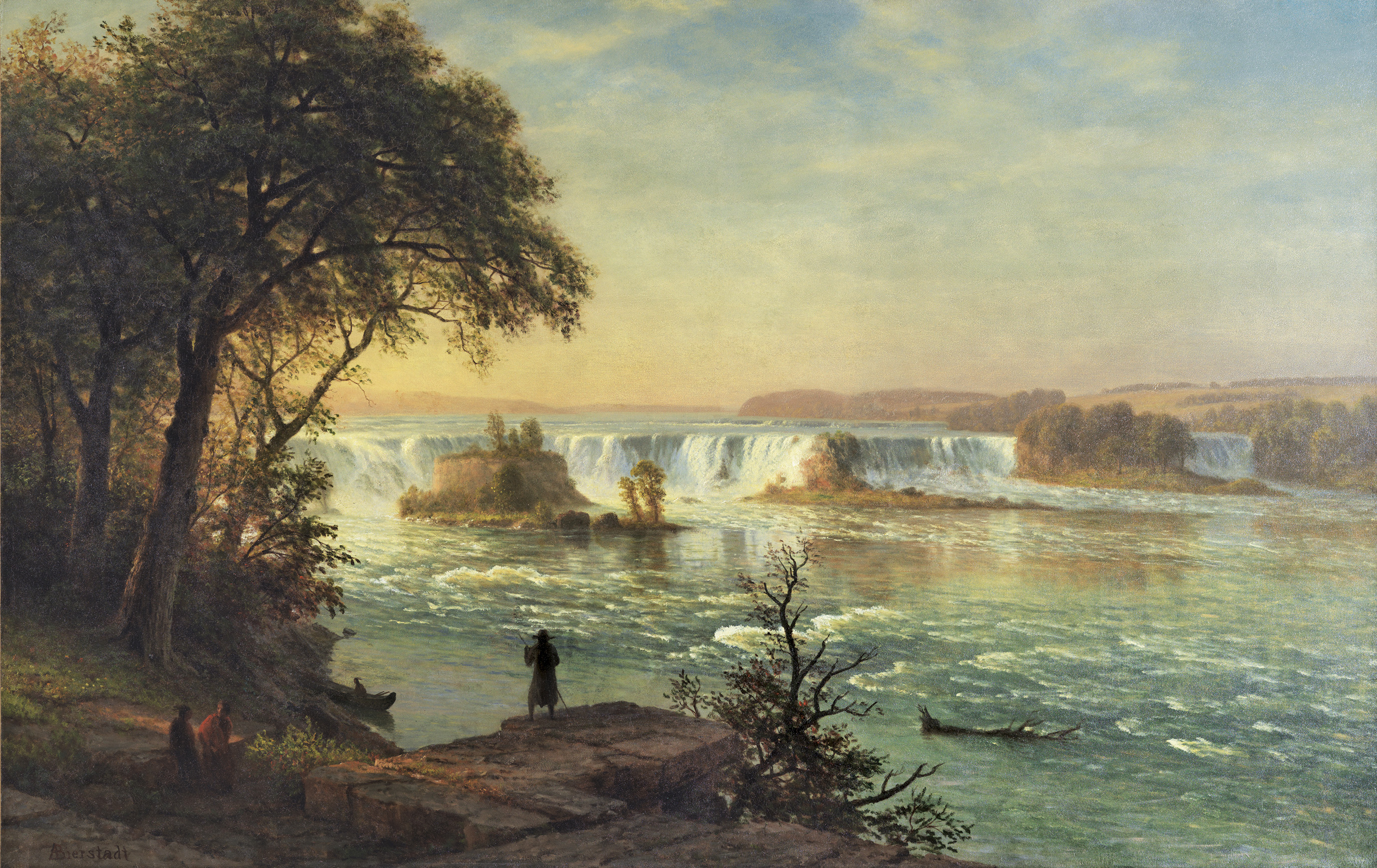
| | | | But look what it says about the Falls. When Louis Hennepin saw it in 1680, this is where it was located, which is actually quite close to where the Lower Lock & Dam are today. Other locations are shown, including what Zebulon Pike saw in 1805, just 125 years later. Apparently the falls were in the process of self-destructing before any of the mills came. | | | | | | Let's have a bit of an art gallery here. Hennepin's view is quite possibly what Albert Bierstadt tried to visualize in his painting we saw in the last posting, which we'll show again now, of St Anthony Falls, though he painted an idealized version in the 1880s.
We also said above that George Catlin, of the Fashionable Tour, painted the falls. This is Catlin's painting entitled The Falls of St Anthony. It's much more solemn than Bierstadt's, but typical of the Catlin's somber Indian portraits. Catlin painted it in 1871, and no industry is shown, so it's hard to know if it represents the falls then, when he first saw them in 1835, or earlier, from his imagination, as Bierstadt did.
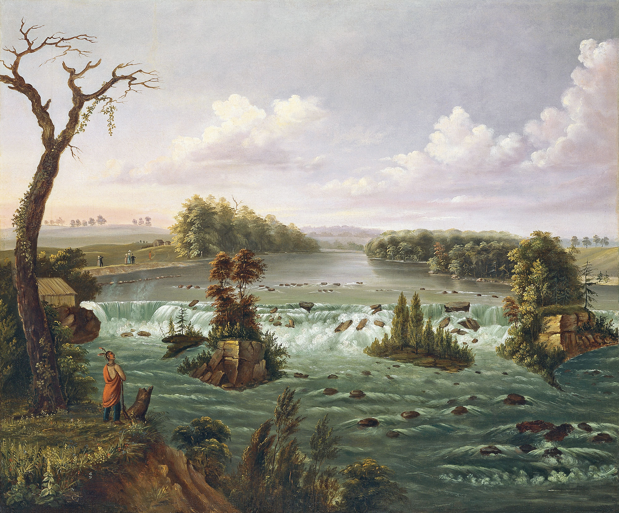
And finally, we have a painting by American artist Henry Lewis, known for his paintings of the West. This is his Falls of St Anthony, done in 1847, the earliest date of these three paintings. Might it be more accurate? It still doesn't show any mills.
I find one thing about this quite amusing. We said earlier that Bierstadt's painting is now located in the prestigious Thyssen-Bornemisza Museum in Madrid, near the Prado. But it turns out that that same museum is the location of both the Catlin and Lewis paintings. Could this museum be trying to corner the market on 19C paintings of St Anthony Falls? Just kidding. If by any chance they display them together, it would make the same nice contrast we just had in our little art gallery.
|
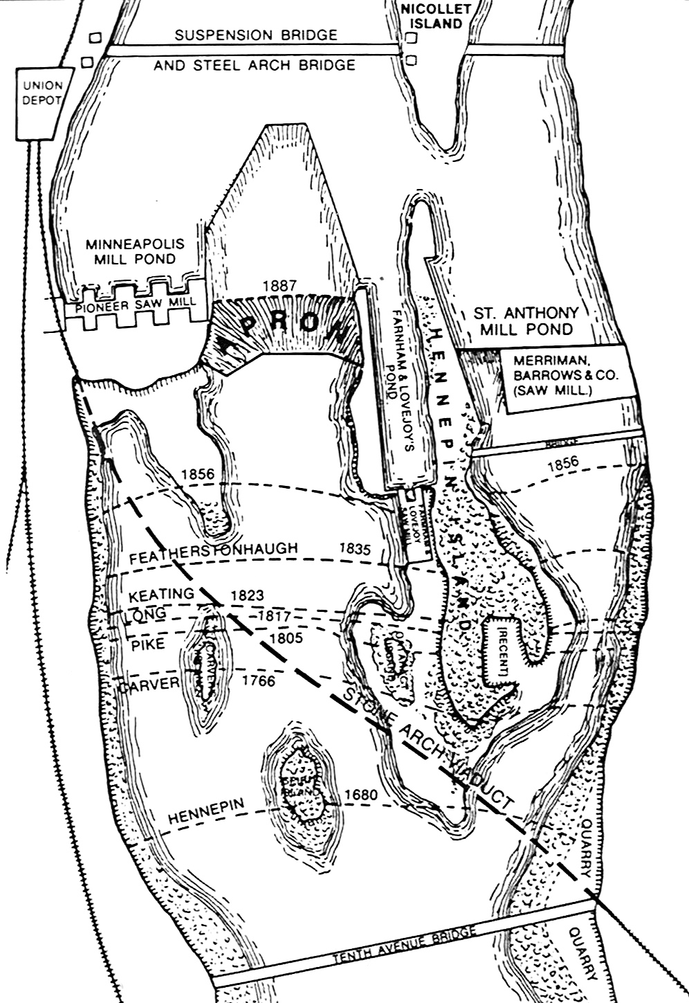
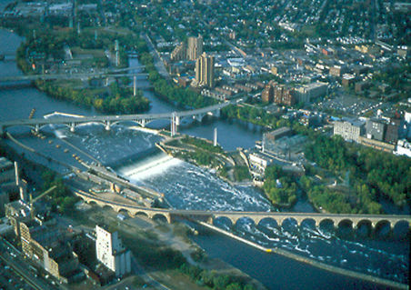
| | | | But industry did harm the falls. The early dams built to harness the waterpower exposed the limestone below to freezing and thawing. Note the two sawmills on this map, also this 1860 sawmill, and also the well-known Pillsbury "A" Mill and another flour mill, the Phoenix Mill, right at the falls. The dams also narrowed the channel, speeding up water flow and increasing damage from floods. It began to look like the falls could become rapids, useless for waterpower, so when the natural falls partially collapsed in 1869, they were replaced by a concrete overflow spillway, also called an apron (as on the map). The work was eventually completed in 1884, although the map shows recession up to 1887. Also note the unusual coffin-shape waterflow upstream of the apron—it might be a part of it, I don't know. | | | | Then, as said, in the mid 20C locks were added to the dams, further altering the general configuration of the river. Today, St Anthony Falls are defined primarily by the Upper Lock & Dam and secondarily by the Lower Lock & Dam. | | | | In addition to Nicollet Island, also note on this map Hennepin Island, which today is more configured into the shoreline. And you cannot miss the graceful swoop of the route of the 1883 Stone Arch Bridge, starting out crossing the river diagonally, then becoming parallel to and joining the west bank. It originally went into Union Depot, as shown, which was the predecessor to the now also lost Great Northern Depot James J Hill built. | | | | We have an excellent aerial view (Photo by Mulad) of what we've just seen on the map, and you should recognize much of what's there. We start at the bottom with the distinctive curvature of the Stone Arch Bridge, formerly for rail, but which today is for pedestrians and bikes. Above that is the Upper St Anthony Dam, with the distinctive coffin-shaped water pattern upstream. To its left is the corresponding lock, and on shore are the mill ruins of the Mill City Museum with the "Gold Medal" sign, and Mill Ruins Park. The green park area to the right includes Hennepin Island, almost part of the shoreline. Crossing above the falls is the 3rd Avenue Bridge, also called the Central Avenue Bridge because of its east bank connection. Crossing Nicollet Island are two bridges, first the Hennepin Avenue Bridge, which splits in two as it approaches the east bank, and beyond it a rail link operated by the BNSF Railway, which now serves the Northstar (commuter) Line.
http://www.mnhs.org/places/safhb/images/riverFrontMap_zoom.jpg
| | | | This is now the outstanding ● third map, which we'll be using from now on. It has everything along the river you'd want to experience. Let's first get oriented in town, where we see it's a bit dated. At the bottom we see the Blue Line, here still called the Hiawatha Line. We do not yet see the Green Line, coming from the right and joining in at the Downtown East Station. Also, the extension of the dual lines one more stop to Target Field is not shown, where it abuts the Northstar Line, whose tracks we do see. The Foshay would be four blocks south on Marquette at 9th. We see the Nicollet Mall, and between it and Marquette above 3rd, abutting the park, is Marquette Plaza, with its internal catenary suspension. | | | | We left off at the 10th Avenue Bridge, here shown properly connecting to 19th Avenue and no longer Cedar, the new I-35W Bridge, and the Lower St Anthony dam and lock. As we continue on West River Parkway, we briefly pass by the new location of the Guthrie Theater. The original theater came to Minneapolis in 1963, the year after I did, and was located for many years southwest of downtown, on an extension of 15th Street W. In 2006 it moved to its new location, here, right on the Mississippi. This is the new Guthrie Theater (Photo by Appraiser) facing the river. Its main theater replicates the signature thrust stage of the original theater, and also features architecturally a 54 m (176 ft) cantilevered bridge facing the Mississippi, visible at the left of the picture. | | | | | | In 2007, the year after this new building opened, I saw an excellent production of the musical 1776 (2007/13). It was the third time I'd seen it. The first time was in its original 1969 Broadway production, where it won the Tony Award for Best Musical. But the second time was by far the most memorable. During the bicentennial year of 1976, Beverly and I went to Philadelphia, where performances of 1776 were being given in a tent right on Independence Mall, opposite Independence Hall, where the actual action had taken place.
I saw 2-3 performances in the original Guthrie Theater. The very first one was in 1963, the same year the theater opened. It was Arthur Miller's Death of a Salesman, with none other than Hume Cronyn and Jessica Tandy. I've been saying for the last half-century that that production was the most memorable and most moving dramatic experience I've ever had, and that includes productions on Broadway, London's West End, or in Germany or Austria. It had one odd quirk. Jessica Tandy had broken her leg, and did the entire performance on the thrust stage in a wheelchair, with one leg in a cast pointing forward. The production so transported you that you did not notice the wheelchair at all, and emotionally were lifted out of the theater, so that when the lights came on at the end, you just sat transfixed for a moment. THAT's what I call a good production.
|
| | | | We then pass (see map) the Mill City Museum (Photo by McGhiever), built on the ruins of the Washburn "A" Mill next to Mill Ruins Park, right on the river. The mill complex dates from the 1870s, is on the National Register, and is part of the St Anthony Falls Historic District. It still sports its "Gold Medal Flour" sign on top. | | | | Right at the mill and park is the iconic Stone Arch Bridge--the previous picture of the mill was taken from it. Again, it was built by Hill for the Great Northern (GN) Railway in 1883 to connect to the first of two now-lost stations. It's the only stone arched bridge over the entire Mississippi. Now that the original Hennepin Avenue Bridge, the first ever, is long gone, the 1874 Eads Bridge in St Louis is the oldest on the river, but the Stone Arch Bridge is second oldest. It is also a Historic Civil Engineering Landmark, on the National Register, and in the Historic District. | | | | This is the bridge c 1905, when all the arches were still intact. Click to inspect the logs floating downstream. This is a postcard photo of the GN's Empire Builder c 1929-1940s, still using a steam locomotive. Notice "Pillsbury's Best Flour" on the mill in the background, on the former St Anthony side of the river. Finally, we have a hand-colored postcard taken from a black-and-white photo, c 1939, of the "Twin Cities 400" (Postcard from the MCAD Library) streamliner of the Chicago & North Western RR, Chicago-bound. This would be the closest in style to the diesel Beverly and I took after the wedding in 1962, loaded with gifts, from the GN Depot, over the Stone Arch Bridge, stopping in St Paul, on the way to Chicago, for connections to New York. | | | | This is finally a panoramic, contemporary view of the bridge (Photo by SamRushing). Click to inspect the falls beyond, and the pedestrians crossing the 640 m (2,100 ft) span, as Beverly and I did once, round trip from the east bank. The width is 8.5 m (28 ft). You'll also see toward the left how the bridge was "altered" (disfigured!), so that, along with 21 stone-arch spans, it also has one (rather ugly) steel-deck truss span, replacing two original arches. This happened during lock construction in 1963, to allow clearance for barges in the lock. This detail (Photo by Appraiser) better shows the lock below. | | | | When walking across the bridge, you get a nice view of the Upper Dam & Falls (Photo by Angela), along with the 3rd Avenue Bridge. You also get to appreciate the gentle curve of the bridge even more (Photo by Steve Karolek). (Speaking of all these bridges, we can add the fact here that no highway or railroad tunnels have ever crossed UNDER the Mississippi River.)
| | | | Continuing on the Parkway, we cross under the Third Avenue Bridge and reach the contemporary (fourth) Hennepin Avenue Bridge, the first one of which was the very first permanent span to cross the Mississippi, in 1855. You'll note on our map that there's a small park here, which I have not visited, but which apparently exhibits pilings and artifacts from not only the first, but the other bridges. At least the "first" distinction has not been forgotten. | | | | We said the Northstar Line serves commuters going to the northern suburbs along the river, something we'll note again tomorrow when we're there. You can see how the tracks from the station at Target Field (not shown) cross here to, over, and beyond, Nicollet Island. I'm pleased to find out on this map that this bridge is called the St Paul & Pacific RR Bridge, named after that very first railroad in MSP, which was taken over by Hill for the GN. | | | | The Parkway at this point gets beautifully leafy. We pass the Plymouth Avenue Bridge, which connects to 8th Avenue NE, because we want to go just a little bit further up to the end of the historic district and cross the Broadway Avenue Bridge, at about 11th Avenue NE. This done, we leave the ex-Louisiana Purchase, ex-Iowa Territory side of the river and will remain for a couple of days on the ex-Northwest Territories, ex-Wisconsin Territory side. Just a bit of that difference can still be found here, not least of which is that we're now in ex-St Anthony, also called St Anthony Main because of the importance of its Main Street, which you'll find on the other side of the map. | | | | Now this map is highly river-oriented, and streets on both sides are parallel or perpendicular to it. But you have to remember, that in reality, downtown Minneapolis lies to the southwest, and ex-St Anthony lies to the northeast. This results in how streets are named and numbered. Downtown being the core, it DOES NOT use the term "southwest". All its numbered streets, either W or E of Hennepin Avenue (the Avenues are N or S). Find 2nd Street N and 2nd Street S. | | | | But on the other hand, the east bank DOES use the term "northeast", and is, in fact, called officially Northeast Minneapolis. Again, Hennepin Avenue is the dividing line, and note that where we are at the moment, ALL streets--and avenues, too--use the designation NE, with no distinction made. So we are now on Main Street NE. But on the other side of Hennepin,, all streets and avenues use the designation SE—find 2nd Street NE and also 2nd Street SE. That's fine, but the result is that, in common speech, whether NE or SE, everything on this side of the river remains Northeast Minneapolis. So this is where the SE is located in the NE! | | | | On Main Street, we're just across the East Channel of the river from Nicollet Island. We first pass the rail bridge, and then note that the Hennepin Avenue Bridge splits. Downtown Hennepin is two-way, but here it's one-way, and is paired with one-way 1st Avenue NE. And then we find the modern entrance to Nicollet Island, the charming little Merriam Street Bridge (Photo by Todd Murray). This picture is taken from Main Street NE, entering Nicollet Island at Merriam Avenue—you'll note on the map that the small island streets have their own names, and don't fit into the city grid, which is, of course, a large part of their charm. I thought at the time that, from its style, this bridge must have been here "forever", but only now am I surprised to find out where it came from—the Broadway Avenue Bridge we just crossed! That bridge was first built in 1887, and was very decorative. Just a century later, in 1887, the Broadway Avenue Bridge was reconstructed, and one of its spans was brought here to become this petite bridge. So this bridge has been here only almost three decades, yet is a century-plus-three decades old! | | | | After years of knowing Nicollet Avenue with its Mall (local pronunciation often shortens it to NIK.lit), and also of Nicollet Island, which I'd never visited before, I've now found out who Joseph Nicollet was. He was a French geographer and cartographer who mapped the entire Upper Mississippi and the Missouri in the 1830s, just over a decade after Fort Snelling was founded in 1819. And Nicollet Island is a survivor. In the early 19C, it was one of six islands near the falls, but with the receding of the falls, all the others were either destroyed or joined to the east bank, as we saw Hennepin Island was. If the falls had continued north and not been stopped in the late 19C with dam and spillway construction, Nicollet Island would also no longer exist. | | | | Go back to the map, and find the surviving building on the island side of the bridge at Merriam Street. This is the lush 'n' plush Nicollet Island Inn (Photo by Appraiser). It's an upscale venue, with a fancy restaurant, and also hotel facilities. It's popular for weddings and large affairs. But how did it get here? Recycling. The building was first constructed in 1893 as the Island Sash & Door Company. Its limestone construction is unique to a time period that depended on cut limestone bricks as its primary building material. The building gets both a casual and solid appearance from the bricks being laid in a random ashlar pattern (see below). In the 1970s, the walls were reconstructed, and windows were added in a regular pattern all around, which changed the building's appearance from industrial to residential. | | | | | | Every time I come across the word "ashlar" in architecture, I know it's a form I like, but can't remember just what it is, and have to look it up again and again. Simply put—maybe I can remember it this way—if a stone wall is very attractive, it's almost assuredly done in an ashlar pattern. "Ashlar" means that the masonry is finely dressed, meaning precisely cut on all adjoining faces to fit together, usually with mortar. The stones can be rectangular, yielding a very geometric look, or can be in a random pattern, as here. Note on this building that each row varies in thickness as it goes along. The visible face on rectangular blocks can be left rough, or finished smooth. As you see on the random pattern, the finished face is indeed left rough. |
| | | | Back on the east bank, we'll continue on Main Street, but first have to mention the Ard Godfrey House two blocks inland, which I visited years ago. History is always with us, and the two sides of the river started out differently. Therefore, we have two "oldest houses". In Minnehaha Park, we saw the John Stevens house, which was the first authorized house on the west bank of the Mississippi, built in 1850. | | | | But we're on the east bank of the Mississippi, with a different history, despite being part of Minneapolis, and it also has its own oldest house. The oldest house still standing in ex-St Anthony is this, the Ard Godfrey house (Photo by Mulad), built two years earlier, in 1848, and so actually the REAL oldest house. Godfrey had been recruited from Maine to build a dam and lumber mill at the falls of St. Anthony. The house has been moved four times and now has a University Avenue address just east of Hennepin. Although each of the houses has been moved four times, the Godfrey house has the advantage of being located just two blocks from its original site on the Mississippi River. You may recall that we drove on a Godfrey Parkway in Minnehaha park. | | | | | | I remember that, like the Princess Depot, the Godfrey house is open on weekend summer afternoons only, so when we saw it, it was just sweltering. The best thing I remember about the house was an extremely clever curatorial trick we found. The living room had a beautiful, black pot belly stove with a black stovepipe rising, then bending into the wall. No air conditioner was visible in the historic house, yet it was beautifully cool. When we approached the stove, we found that its front grate was shooting out cool air, which came down via the stovepipe. Clever curators. |
| | | | Down Main Street we come to the former the former Pillsbury "A" Mill, in front of which are Pillsbury Park and Water Power Park, both of which use part of the former Hennepin Island. It's from Water Power Park that we get a spectacular panoramic view of Upper St Anthony "Falls" (Photo by Bobak Ha'Eri), which now are a concrete spillway, as in Ottawa (2013/2). The concrete wall across the spillway is the lock wall. Click to see the replaced portion of the Stone Arch Bridge; above it is the Guthrie Theater, in black; to the right of the Guthrie are the white silos and reconstructed shell of the former Washburn "A" Mill, now the Mill City Museum, as well as other former mill buildings. | | | | To get to the comfortable University Inn for the night, we have to take eastbound University Avenue SE to 10th Avenue SE, then avoid the bridge by turning left to 4th Street SE, and there we are. We are directly adjacent to the area called, curiously, Dinkytown, which is the student-and-faculty housing, shopping, dining, and entertainment area. It centers four blocks east, on 14th Avenue, after which the University's East Campus begins. And so we end another well-spent day. | | | | Over the years, it never struck me until now how much more the Minneapolis Riverfront offers than other locations on the Mississippi. The importance of New Orleans lies onshore, and its Moonwalk on the Mississippi levee is pleasant, but not the primary reason to visit Nola. The Gateway Arch in St Louis is spectacular, but is not river-related. When you consider the Mississippi in Minneapolis, from Fort Snelling and Minnehaha Falls, up the Mississippi Gorge to the Downtown Riverfront, with its falls, dams, locks, bridges, islands, mill ruins etc, etc, all directly river-related, it now seems to me that Minneapolis is the winner in our little Riverfront contest. | | | |
| |
|
|
|

