|
Reflections 2016
Series 5
April 5
Mississippi River XI: Fort Snelling Confluence - St Paul – Minneapolis-1
| | We now come to the last state on this trip, one in which I have a lot of background. Beverly was from Bloomington, to the south of Minneapolis, and when we came back from the year in Mainz in August 1962, we flew there to get married. In the decades since, we'd visit Minnesota at least once a year if not more, to visit family and many friends. I think I can say I know Minneapolis & St Paul (MSP) and the rest of the state as well as anyone who hasn't actually lived there. | | | | Other than holiday visits, we often worked Minnesota into summer trips in the US. Over the years I've arrived in MSP by car from east and west, by train (Empire Builder) from east and west, and by plane from the east from New York, from the west from Alaska, and that one year, from the south from Mexico City via San Antonio. This year was unique. Not only did I arrive by boat, it was by steamboat, which was the basis of so much history along the Mississippi, including in Minnesota—MSP exist because of the river, and that made it even more of a thrill. | | | | Since Beverly left us in 2004, I visited her widowed mother—plus more family and friends—every year through 2008, after which her mother was no longer able to recognize me. It was usually connected to other travel, like coming back from the Dominican Republic the long way, via MN in 2006, flying back from Alaska (2005/13), continuing on to Denver and Aspen, then the west coast and Hawaii (2008/18-25). It was on this last trip that I went out of my way to drive over the rebuilt I-35 Mississippi River Bridge that had collapsed into the river the previous year (more to follow). In 2007, it worked out that Tim Littler of GW Travel in the UK was going to be in Minneapolis, and we got together, then rode the new Blue Line streetcar downtown for dinner (2007/13). Since my mother-in-law died in December 2011 (two months after my own mother in New York), I hadn't been back until now—and arriving by steamboat. | | | | I wrote a three-part "Minnesota Trilogy" (2003/2-3-4) about the interesting geography and history of the area, plus a point about language. I'm going to summarize—and improve on—each part as it comes up, since so much of it is based on—what else?—the Mississippi River, our presently concentration. | | | | Geography: The Confluence in Minnesota Let's start with the below simple map that shows you just where we're going:
http://media1.s-nbcnews.com/i/msnbc/Components/Maps/Americas/Lake_Itasca.gif
| | | | You see where we came up the river from Iowa and Wisconsin, passing the confluence with the St Croix, which forms the MN/WI border, for our arrival in St Paul. We'll spend a couple of days in MSP before continuing by car to follow the Mississippi to its source in Lake Itasca. You can't help but noticing how the route of the uppermost Mississippi, called the headwaters, forms a question mark. Minnesota is famously known as the Land of 10,000 Lakes, and with good reason, since they are everywhere, including within MSP. Actually, that number is just a rounding off, since officially there are 11,842 lakes over 4 hectares (10 acres) in size. On the map you see the largest interior lakes in the state, and we'll be passing them all later on. | | | | But our "river story" is more than that. Take a look at the route of the Minnesota River (Map by Kmusser), after which the state is named and whose watershed fills most of southwestern Minnesota, but which starts on the border with South Dakota. (Note now, for later discussion, that odd, very abrupt "elbow" bend in the river at Mankato, a 90° turn sending the river to MSP.) Of importance to us, though, is that its confluence with the Mississippi is right between Minneapolis and St Paul. This geographic point is a main point about the settlement history that follows. | | | | But let's first go way back in time. We're going to find out that the uppermost Mississippi River originally was not necessarily that question mark in central Minnesota, but in reality, that was only a local stream leading down to the Fort Snelling area. So what was a lengthier—and more spectacular—source of the Mississippi?
http://www.dandebat.dk/images/1488p.jpg
| | | | As so often is the case, you have to go back to the Ice Age, which we've done in the past in regard to the Great Lakes, the Hudson River, and much more (2010/25). Glaciers moved through the area again and again from 2 million years ago up to 10,000 years ago. The last glaciers did so about 14,000 years ago when the Laurentide Ice Sheet covered the area shown in the map. (On the Greenland trip, we also discussed in 2013/23 the Greenland Ice Sheet, which still exists.) The map shows the maximum extent of the glaciation. It is my personal speculation that it is not a coincidence that the Missouri River in the west, and the Ohio River in the east, seem to follow the shown border rather closely. It's also of interest to see how the formation of the ice took up so much seawater that the continental shelf was exposed as shown, including the Alaska-Siberia connection. But, as usual, I digress.
http://www.oldnaturalist.com/wp-content/uploads/2015/07/Agassizmrbdc.mnsu_.edu_.png
| | | | But all things come to an end, and, about 12,000 years ago, the glaciers melted, and the ice cap retreated. In addition to local streams the glaciers left behind formed by the meltwater, the spectacular thing they left was Lake Agassiz (AGGA.si), larger than the Great Lakes today, and centered in what today is Manitoba. (The borders of the lake shifted, so the lake was never quite this large all at one time.) Before we leave this map, take a close look at Minnesota and you'll see the question mark of the proto-Uppermost Mississippi and also the proto-Minnesota River seemingly starting at the South Dakota border, as we mentioned above. Both were just sandy glacial streams. | | | | We last discussed lake Agassiz when riding the train from Winnipeg to Churchill up on Hudson Bay to see the polar bears (2011/29). The remains of the lake are today Lake Winnipeg, Lake Manitoba, and the others shown (Map by NormanEinstein). (Take careful note of Lake of the Woods for future discussion, because we're going there shortly.)
http://bloximages.chicago2.vip.townnews.com/mankatofreepress.com/content/tncms/assets/v3/editorial/d/c2/dc263714-e47c-573d-89eb-f5b026cb8498/5500b49ff317d.image.jpg?resize=760%2C576
| | | | Then there were other changes. As the red arrows show, Lake Agassiz sprung leaks in some very interesting places: northwest to where the Mackenzie River flows today, into Hudson Bay, to the St Lawrence, into the Great Lakes--and to the south. It was about 10,000 to 12,000 years ago that some catastrophic event burst open the banks of the lake near the South Dakota-Minnesota border. The water poured out, and took over the valley of the quiet, proto-Minnesota River in a huge flood. For many hundreds of years, huge amounts of water tore down the valley, gouging it out and widening it. When the water reached what is now Mankato, it hit hard limestone as well as another channel of water coming north, which caused it to make that sharp left turn and course to what is now Fort Snelling and MSP. This huge, gouging river has been named the glacial River Warren, which is the predecessor to today's Minnesota River. This map also shows how the question mark-proto Upper Mississippi was just a tributary of River Warren, as was the St Croix river that forms today the border between MN and WI.
http://mrbdc.mnsu.edu/sites/mrbdc.mnsu.edu/files/public/mnbasin/fact_sheets/graphics/glaciers/riverwarren.gif
| | | | This small map shows, along with River Warren, "beach lines", indicating the extent to which Lake Agassiz lay within Minnesota. Note how all lines merge close together to the west. Now look at this map of the Red River of the North (Map by Kmusser). It starts at the bottom of North Dakota and flows north to form the line between ND and MN, then enters Manitoba to become Winnipeg's River, ending in Lake Winnipeg. Now no one's told me this, but think it through with me. Where the Red River is was the southern tongue of Agassiz. When it stopped flowing, doesn't it seem that the channel split pretty much where ND and SD come together, that the Minnesota River continued SE, and that the balance of the water turned north to Manitoba? Isn't it odd that today these two rivers flow apart from each other, but were apparently all part of the Lake Agassiz/River Warren complex?
http://mrbdc.mnsu.edu/sites/mrbdc.mnsu.edu/files/public/mnbasin/fact_sheets/graphics/glaciers/river_warren_full.jpg
http://4.bp.blogspot.com/-g1OpNy48RNY/UDtDOA48jYI/AAAAAAAAAtg/vbAIQr9RmT0/s1600/Henderson_cross_section.bmp
| | | | These two last links deal with the valley gouged out by River Warren. The first sketch indicates the size of the valley River Warren carved out and filled bank-to-bank, and also the residual water that settled down into the bottom of the oversized valley to become the Minnesota River. The second link shows a self-explanatory cross section of the valley at Henderson MN, which is downstream from the Mankato "elbow" and southwest of MSP. | | | | So shall we call Lake Agassiz the original, prehistoric source of the Mississippi? We can then reflect on Lake Itasca and the "question mark" moving from just a tributary of River Warren-cum-Minnesota River to flipping places, becoming what we today consider the source for our purposes. But we should never underplay the importance of the Minnesota River.
https://dakotasoulsisters.files.wordpress.com/2012/10/fort-snelling-map.gif
| | | | History: Fort Snelling This map serves double-duty. We'll refer back to it as the 1820s-1830s Fort Snelling map. First it shows the confluence in detail. But it also shows the earliest settlement history after the Native Americans. Everything about the settlement and development of MSP can be seen in this map, as Fort Snelling is the historic centerpoint, not only of MSP, but by extension, of Minnesota. You just have to know where on the map to look to see how the history fell into place. | | | | It all started with a familiar name, Zebulon Pike, who we last discussed in La Crosse. In 1805, his expedition up the river brought him to the confluence shown on the map. You see a longish island at the confluence. Pike and his group camped on the island and bargained with Native Americans to acquire over 40,000 hectares (100,000 acres), and thus the island today is called Pike Island. The negotiated territory was located on both banks of the Mississippi, between St Anthony Falls (in present-day Minneapolis) and the confluence of the St Croix River, which today forms the MN/WI border. | | | | Significant settlement at the confluence began in the late 1810s. Then, following the War of 1812, the US built an entire chain of forts between Lake Michigan and the Missouri River to protect this then very distant area from British/Canadian encroachment. The US Army founded Fort Snelling in 1819 as the westernmost US fort, the farthest outpost of the US military. It was at first named Fort St Anthony, but when it was finished in 1825, it was renamed Fort Snelling in honor of its commander and architect. Fur traders, explorers, and missionaries came to this area under the protection of the fort. | | | | The fort's location on the bluffs was perfect for policing, since it allowed soldiers to control the rivers in three directions, including fur trading routes. They tried to restrict commercial use of the rivers only to US citizens, they kept Native American lands free of white settlement until treaties permitted it, enforced law and order, and protected legitimate travelers and traders. Here, they also tried to keep the peace between the Ojibwe and Sioux (Dakota) people. | | | | This greatly simplified map shows how Minnesota (Map by Fay2) was pieced together, becoming a state in 1858. The east bank of the Mississippi came to the US after the Treaty of Paris of 1783 ending the American Revolution. It had numerous names over time, the last one being Wisconsin Territory. The west bank was part of the Louisiana Purchase. It also had numerous names over time, but the last was Iowa Territory. You'll notice how the question mark of the uppermost Mississippi is crucial to these borders. But you might also wonder why there's a straight line from that to Lake of the Woods. Full disclosure comes from this larger US map showing that in 1818, the US and Britain/Canada did a border swap, so that the bits of the Louisiana Purchase (in dark green) were ceded to British North America (Canada), while the British ceded to the US the blue area, which had been part of Rupert's Land (2011/25). Thus, while western Minnesota was taken from Iowa Territory as the first map showed, the history goes back primarily to the Louisiana Purchase but also partly to Rupert's Land. (In retrospect, it's understandable that Rupert's Land had come so farther south, since this cession was the valley of the Red River, which flows north into Lake Winnipeg.) | | | | But understanding how the river divided territories at one time, you can understand that, when John Emerson brought Dred Scott to Fort Snelling in 1837, it was considered to be in Wisconsin Territory, where Dred married Harriet. Although equally a free territory, it wasn't yet Minnesota. | | | | We can illustrate the area in this period. This is an 1850 oil on canvas of Fort Snelling and Pike Island, with the Minnesota River entering on the left and the Mississippi River entering on the right. It also depicts two houses, which are historic and still there, belonging to two people whose names that are well-known in Minnesota. Today the Sibley Historic Site, which I've visited in the past, is the location of Henry Sibley's home, built of stone in 1835-6. He was a fur company regional manager and first governor of Minnesota. The other is the Jean-Baptiste Faribault's home (Both photos by McGhiever), also built of stone, in 1840. He was a fur trader from Québec who refused to fight for the British in the War of 1812, was imprisoned and had his property confiscated. He became an American citizen and moved to Pike Island. We point out these historic stone houses to show that settlement was well underway here, with buildings that were meant to stay. This second painting by John Casper Wild shows Fort Snelling in 1844 and is particularly demonstrative of the attraction of the area. | | | | The usual development of things is that, when you build large facility, a settlement grows around it, as we see. In Europe, so many castles and cathedrals were the center of settlements. For instance, during Charlemagne's time a castle called the Hammaburg (Burg = "castle") was built, around which today's city of Hamburg grew. Castles were military buildings, meant for protection. In the US, forts were built for protection instead, and consequently, often cities grew around them as well. There have been many, many forts in the US—I've just gone through the list. Many of them never became cities, but at least these have--I've checked: Fort Collins CO, Fort Myers FL, Fort Pierce FL, Fort Wayne IN, Fort Madison IA, Fort Worth TX. From a list of a dozen-and-a-half US cities I've seen that, for whatever reason, at least have "Fort" in their name, with the physical connection to the fort perhaps a bit more tenuous (I didn't check ALL of them) I'll cherry-pick these, whose names I know: Fort Bragg, CA, Fort Laramie WY, Fort Lauderdale FL, Fort Lee NJ, Fort Smith AR, Fort Walton Beach FL. I'd make a wild guess that "Fort" might possibly be the most common word that can be found in the names of US cities. | | | | So the question remains, why is Fort Snelling in the group of forts that has no city named after it? Why is there no such city as Fort Snelling MN? Well, it just never happened, because local forces pulled in other directions. Fort Snelling was the impetus that founded both Minneapolis and St Paul, each just a 25-minute drive away from the fort, a history we'll investigate in a moment, but it never became a city itself. It became a full-fledged army base through WWII, then the historic area was separated, while the US decommissioned the active base in parts between 1946 and 1994.
http://www.minnesotamonthly.com/Guides-Resources/Maps/Where-Twin-Cities-Maps/2012-Where-Map-Metropolitan-Area.jpg
| | | | This is the modern MSP map we'll be using. The brown number 8 sort of blocks the location of Historic Fort Snelling, but Pike Island is visible—it's all now the Fort Snelling State Park, and the fort is run by the Minnesota Historical Society. Now compare this modern map with the following one. | | | | Fort Snelling didn't become a city, but not for want of trying. This is a section of an 1860 map of a planned, but never built "City of Fort Snelling". An entire city grid was proposed, and Pike Island would have been part of said city. Lake Harriet on the left still has that name. Rice Lake is now Lake Hiawatha. Lake Amelia is now Lake Nokomis. Mother Lake apparently still exists, but is much tinier. Richfield as a city does exist, but is today south of all the named lakes, with Bloomington to the south of it and Minneapolis to the north (see above MSP map). (You see on the modern map how the MSP airport comes very close to the historic area.) The nearest numbered Minneapolis street is 59th Street, so if the numbers continued south here along the river, Historic Fort Snelling would be in the low 60's. | | | | We can use Kansas City as a model for what happened here. There, Westport was the main center, until Westport Landing-cum-Kansas City became a major urban business center as well as a transportation center on the Missouri, then eclipsed and absorbed Westport. Fort Snelling was essentially absorbed as well, but only after it, too, was instrumental in forming not one, but two cities on the Mississippi. | | | | History: St Anthony-cum-Minneapolis Now look again at the 1820s-1830s Fort Snelling map so we can see how this was done. Look upstream and you find one of the major phenomena on the Mississippi, St Anthony Falls, the only major natural waterfall on the Upper Mississippi. That some sort of industrial settlement of consequence would eventually evolve at the falls seems obvious. As early as 1680, the falls had become known to the Western world when they were seen and written up by Father Louis Hennepin, another historic name often heard in Minnesota (he also first published about Niagara Falls). These falls he named the Chutes de Saint-Antoine, or St Anthony Falls. The influence of these nearby falls was the basis for the original name for Fort Snelling, Fort St Anthony.
| | | | Early on, it was soldiers from Fort Snelling who went up to the falls and built a grist mill and sawmill. This grist mill was the ancestor of all the flour mills that would make Minneapolis hugely famous as a milling center as the city grew—think of General Mills, Pillsbury, others. By the 1880s there were some two dozen huge flour mills along a three-block corridor around St Anthony Falls, and warehouses nearby to service the mills. From 1880 to about 1930, Minneapolis was known as the "Flour Milling Capital of the World", and also "Mill City". After World War I, the milling industry in Minneapolis began to decline, the industry moved away, and the old mills fell into disuse. The Washburn A Mill closed in 1965 and was nearly destroyed by fire in 1991. Its ruins are now part of the Mill City Museum. | | | | After the falls partially collapsed in 1869, the natural falls were replaced by a concrete spillway, which is exactly what we described in Ottawa on the Ottawa River at Chaudière Falls, which had also become industrialized and replaced by a spillway (2013/2). The blockage of the river by the falls did cause the falls to remain the upper limit of commercial navigation on the Mississippi until dams and locks were built between 1948 and 1963, at which point navigation was extended somewhat to points upstream. Actually it wasn't too much further, only, to Coon Rapids Dam in Coon Rapids, which on our MSP map is the next town beyond Fridley at the top. | | | | While the locks technically make some commercial navigation possible above Minneapolis, the locks in Minneapolis are smaller than most of the locks on the river, making the practical limit for many barges further downriver, with only some reaching Minneapolis. There are fourteen dams in the so-called headwaters area north of MSP, but they are without locks, so apparently just allow local recreational use of parts of the river, as well as generation of power. | | | | But we've discussed the falls, and not the settlement, so let's go back to where the soldiers had built some facilities at the falls, upstream from Fort Snelling. In 1848, the land that would become the town of St Anthony was purchased and the first commercial mill was built at the falls. This town was on the east side of the falls, on the east bank. If things had stayed this way, today we might have the twin cities of St Anthony and St Paul. Who knows, we might have called them the Saintly Twins. But that didn't happen. | | | | Four years later, in 1852, the land on the west side of the falls, on the west bank like Fort Snelling, was opened for settlement and became Minneapolis. If this had remained the status quo, we'd have the twin cities of Minneapolis and St Anthony, and in the distance, St Paul as an outlier. But that didn't happen, either. | | | | | | I've known for a half century about Minneapolis and St Anthony having lain on opposite sides of the river, having been founded separately. Only now does it strike me why, which is why I love to continue my self-education by researching and writing these postings. From what we've discussed, do you see one reason?
What I see is that they had been in two separate contributing territories. The east bank came from Wisconsin Territory, the west bank from Iowa Territory, and the splitting away from those two from those came in 1849, while statehood came in 1858. Perhaps getting established in what had been two different entities, could be a factor, especially when we see that Minneapolis was founded just in 1858, the year of statehood.
|
| | | | The two stayed divided for a while. St Anthony became officially incorporated in 1855, three years before statehood and before Minneapolis was settled. Minneapolis didn't become incorporated until 1867, so there was a 12-year difference in their ages. They continued to coexist as two different (twin!) cities until 1872, when they agreed to merge, in order to use their economic power for milling operations. But the merger took place under the name Minneapolis. | | | | So just as Fort Snelling became part of greater Minneapolis by the early 20C, St Anthony, which still has its own Main Street running parallel to the Mississippi, early on became known as Northeast Minneapolis. Worse, a township further northeast than St Anthony-cum-Northeast Minneapolis later incorporated under the name St Anthony, so the old St Anthony couldn't even use that name, even historically. However, it does refer to itself by the unusual name St Anthony Main, especially for the long stretch along Main Street. | | | | I've waited to this point to insert a historical painting. It was painted by none other than German-American artist Albert Bierstadt of the Hudson River School. We last discussed both him and the School in Ecuador, along with Frederic Edwin Church (2015/16). Bierstadt came to Minnesota and painted this sometime between 1880 and 1887. The painting is now located in the prestigious Thyssen-Bornemisza Museum in Madrid, near the Prado. This is Bierstadt's Falls of St Anthony. | | | | It's a beautiful painting, typical of the Hudson River School, but has to be seen as an idealized vision of something Bierstadt really didn't see, since he didn't paint it until the 1880s. At that time the area would have been surrounded by flour mills, and the falls would have been a concrete spillway since 1862. This would be more what Hennepin had seen, and what those first mill-building soldiers would have seen. St Anthony would have been built on the opposite side, and we're standing in what would become the original part of Minneapolis, where we see three figures. But it IS nice to dream. | | | | History: St Paul While I've visited St Paul in the past, I never could make out any background as to why it's there. I would hear from local people I knew a loopy story about a guy named Pig's Eye who had a tavern there and the town around him became known as Pig's Eye. (This weird early name of St Paul is surely the part that appeals most to people, making it reasonably well-known information). It wasn't until later that a St Paul's church was established and that name replaced Pig's Eye. Loopy, right? The thing is, it's true. But that doesn't explain why St Paul is located where it is, does it? After all, there's no waterfall there!
| | | | Part of the story is indeed the story of Pig's Eye as he was connected to Fort Snelling, but the other part, which we'll tell second, is the major reason why St Paul grew into a major city and didn't remain a little village. This is what really pleased me to have finally found out. | | | | That small settlement developed near the fort, down by the river, as we've seen. There were squatters, government officials, and travelers. Many were Québecois, including a retired trader who'd turned bootlegger named Pierre Parrant. He was blind in one eye, which got him the nickname of Œil de Cochon, or Pig's Eye. When he arrived in 1832, he settled in the squatter's colony near Fort Snelling and set out to set himself up as a businessman distilling his own liquor. He sold it to other squatters, Native Americans, and even soldiers in the fort. All went well until 1838 when the squatters were forced off the land near Fort Snelling, partly because of the whiskey trade, and partly because it was claimed they were depleting the resources in the area. The army moved the squatters further downriver to the low riverbank that is today Lowertown St Paul. | | | | | | Before we continue, consider again the geography. Upriver was St Anthony Falls and a developing mill area. Between the falls and the fort were river bluffs, now called the Mississippi River Gorge, and then the bluffs continue past Fort Snelling and a bit beyond. But a little further downriver is a geographic shift just like what we saw in Dubuque, where the river bluffs were inland, leaving bottomland for downtown Dubuque to develop. In what became St Paul on the east bank, the river bluffs suddenly leave the river and run inland at an acute angle to the river, leaving a bottomland space that became the center of St Paul, whose area closest to the river I've now learned is called Lowertown. And up on those bluffs there developed in the late 19C an upscale neighborhood centering on Summit Avenue, which also gives the neighborhood its name. No funicular, though. More later. |
| | | | So there was a location downriver for the army to move the squatters to. How it would grow to a major city will be our second point, though. Meantime, Pig's Eye Parrant had a bit of luck. He moved there and found a piece of land that included a cave with a spring in it. He put a claim on the land, and on or around 1 June 1838, he completed building a small shack which is today referred to as the first dwelling and first house of business in what became St Paul. Therefore, to the consternation of some historians, this disreputable character became the first non-native resident of St Paul. Since the spring in the cave provided a steady water supply for his still, this place of business was—you won't be surprised--a tavern, called—no surprise again--the Pig's Eye. The tavern became wildly popular with the surrounding community, riverboat crews, and, as ever, Fort Snelling soldiers. | | | | Parrant and his tavern had become so popular that a local resident wrote away to a friend in 1839 and listed his return address as "Pig's Eye". Not long after, the resident actually received mail back that was sent to that address. In this way the growing community became known as Pig's Eye. That name might have remained to this day ("the twin cities of Minneapolis and Pig's Eye"), except for the fact that in 1841 a chapel was established in the area (later to become the Cathedral of St Paul) and the Catholic priest was so aghast at both the local name and the unsavory reputation of the man it was named for that he declared that the settlement would from then on be named after that chapel, St Paul. | | | | But perhaps Parrant is still chuckling about one thing. Take a look at the map of MSP. Move downstream from downtown St Paul to where a little bay on the east riverbank abuts the river, and you'll find that, to this very day, that bay is called Pig's Eye Lake. | | | | | | There's one more bit of off-the-wall St Paul history I want to insert here, just because it's fun. When the Minnesota Territory was formalized in 1849, St Paul was named its capital. But in 1857, a year before statehood, the territorial legislature voted to move the capital to St Peter, which is SW of MSP on the Minnesota River, just north of the "elbow" at Mankato. The reason for the change was that St Peter is it's more centrally located within the state. But one territorial legislator, Joe Rolette, didn't like that idea, so he stole the physical text of the approved bill and went into hiding. Without that text, the move was prevented, and when statehood came, St Paul was still the capital. |
| | | | So what was the second, and far more important, thing, that transformed this little community into a major city? Nothing other than steamboats! So much so that maybe St Paul should have renamed itself once again as "Steamboat City"! Of course learning this fact made me that much happier that I'd arrived on a steamboat this trip for the first time ever. Still, I really feel it's almost unknown among locals what the importance of steamboats was. Later, as in St Louis, railroads took over from the steamboats, but St Paul retained its importance then as a transportation hub. | | | | Steamboats started out in the 1820s with a big bang, and the golden age of steamboats was the period 1830-1850. Since the army moved the squatters from the Fort Snelling area to Pig's Eye-cum-St Paul in 1838, that move fell right into the onrush of steamboat traffic. This is a couple of decades before the earliest railroad period in this area, and local roads along the upper Mississippi were few and far between, steamboat traffic on the Mississippi was the ideal solution. | | | | We've seen how navigation as far upstream as Minneapolis, even with today's dams and locks, is difficult, so you cannot imagine Minneapolis, lying right on the Mississippi, as any sort of a river port, either today or in the past, as you can with so many other cities. I would go out on a limb and estimate that Minneapolis is possibly the biggest city on the whole Mississippi-Missouri-Ohio River complex that isn't, or hasn't ever been, a river port of consequence. | | | | To confirm this, let's take another look at a sketch we showed in 2016/4, the one showing the "stairway of water" coming up the Upper Mississippi because of the dams and locks that were built later. At that time, we pointed out that not only is the river at St Paul already noticeably higher than downstream, there's an additional stark rise in the river right within MSP as it reaches even the Lower St Anthony Falls Lock & Dam in Minneapolis, to say nothing of the Upper one. We can imagine that in the pre-dam period, Minneapolis was just that more difficult to reach, and was not a contender to become a river port. At best, steamboats could make upriver excursions out of St Paul toward Minneapolis, but to my knowledge, there weren't any docking facilities of consequence north of St Paul.
https://www.nps.gov/miss/learn/education/images/LambertLanding_rev_1000_2.jpg
| | | | And so it was St Paul that became the "end of the line" for river traffic, which made it thrive (see painting on above link). There was major construction from the Lower Landing up to 4th Street inland. In this period, St Paul ended up with not one, not two, but three steamboat landings! In that period, of the three, St Paul's Lower Landing was one of the busiest steamboat landings in the entire US. Until the rail era started in the 1880s, Lower Landing was the main source of supply and communication for MSP. In its heyday, it served as the point of arrival for tens of thousands of immigrants entering Minnesota, and also for those going on to the Dakota Territory. That can be understood since each steamboat carried several hundred passengers and the number of steamboat arrivals grew from 41 in 1844 to 256 in 1854 to 1,068 in 1858, the year of Minnesota statehood. At this point, steamboats arrived at an average of 2.8 a day. Since St Paul was the last accessible point on the riverbank to unload boats coming upriver, it acquired the nickname The Last City of the East. | | | | But while St Paul continued to be a transportation hub, steamboats declined and railroads took over. But at first, they complimented each other. In 1857, the Minnesota legislature issued a private charter to build an extensive railway from Wisconsin, across Minnesota, and beyond. But then the state had to later take it over, giving it the new name of the St Paul & Pacific RR (SP&P). Interestingly, though, the first stretch actually built, as of 1862, were 16 km (10 mi) of track between Lower Landing in St Paul and St Anthony. Remember, St Anthony didn't merge with Minneapolis until 1872, and anyway, by having St Anthony as a temporary terminus, the route was all east bank, and they avoided having to cross the Mississippi, particularly difficult at the falls. I think that it can be assumed that this stretch of track was the first built because St Paul, as the transportation hub, was serving St Anthony/Minneapolis, as the milling center. At this stage in history, rail 'n' sail complemented each other, and this stretch of track functioned as an extension of steamboat service up to St Paul. | | | | | | The SP&P, which even had "Pacific" in its name, never got there on its own. It was taken over in 1879 by the Canadian-American railroad tycoon James J Hill, who used it, in combination with other railroads he acquired, as the basis for the northernmost transcontinental railway in the US, his Great Northern Railway (GN), a name he gave it in 1889. The GN made St Paul the most important rail transportation hub in the Upper Midwest. It was the only transcontinental railway that was privately built, without any government land grants to foster growth. The GN crossed the Mississippi to Minneapolis over the graceful and beautiful Stone Arch Bridge, the only stone bridge to cross the river, now a delightful pedestrian crossing (discussed later). The GN was part of the 1970 merger of several railroads, including the Santa Fe we recently discussed in Kansas, and became the Burlington Northern-Santa Fe (BNSF). Because of the size of the area involved with the GN and its economic power, Hill became known during his lifetime as The Empire Builder. Since 1929, a train, the Empire Builder, named after him, has connected Seattle/Portland and Chicago, first under the GN, now as part of Amtrak. I've used it many times, and we'll take that train when we leave Minnesota at the end of this trip. |
| | | | Do remember that that first rail line started right at Lower Landing. It is no coincidence that that's where St Paul's rail station today is located, with a front facing 4th Street. It was in 1879 that ten railroads formed the St Paul Union Depot Company, and the depot opened in 1881. By 1883 Union Depot received 155 trains a day, with 14,000 passengers and 3,500 bags. 17 tons of mail and 200 freight cars were processed daily. In 1889, 8 million passengers passed through the station, and up to 268 trains a day. A new depot, the present one, was built in neoclassical style between 1917 and 1925, the delay being due to WWI. By the early 1920s, there were 282 trains and 20,000 passengers a day, using 10 platforms serving 20 tracks. | | | | Then, just as steamboats had declined, rail service did the same as the mid-20C approached—the same story we saw in St Louis—as cars and planes started to carry the bulk of passengers. A few days after Beverly and I got married in Minnesota in August 1962, we left for Chicago on the Empire Builder, to connect to New York. We left from the 1913 GN Depot in Minneapolis (this is a postcard c 1930), crossed over the Stone Arch Bridge, then stopped at St Paul Union Station, on the way. | | | | Amtrak was founded in 1971, and it decided that two stations in MSP were one too many. It chose the GN Depot in Minneapolis to be the sole MSP station, and that same year, the last passenger train left St Paul Union Depot, on 30 April—it was the westbound Empire Builder. Then, in 1978, Amtrak built a new, small station halfway in between the two cities, in the St Paul neighborhood of Hamline-Midway, and diplomatically called it Midway Station (Photo by McGhiever). We used it a few times for the Empire Builder, but it was in the middle of nowhere, nice enough, but would reflect the urban pride only of a small town, not a big city, and certainly not two big cities. The same year, 1978, the GN Depot in Minneapolis was demolished. Sic transit. Pun most definitely intended. | | | | Then, fortunately, things began to improve (got less "sic"?). In 1974 the St Paul Union Depot was placed on the National Register of Historic Places. It took quite a bit longer, but in 2006-2008 the Ramsey County Regional Railroad Authority purchased the Depot and rehabilitated it. In 2012, the renovation and restoration were complete, and, happily, on 7 May 2014, Amtrak closed down Midway Station and returned to St Paul Union Depot as its one and only stop in MSP. We'll visit it shortly, but it's been done similarly to Kansas City Union Station: it's a large event space, has shopping and restaurants, and, unlike St Louis Union Station, has an Amtrak sales office and waiting room. The tracks below, though. are greatly reduced to just a couple, and there is also a bus station. | | | | Back to steamboats for a moment. St Paul's Lower Landing was reconstructed in 1937 by the Works Progress Administration (WPA) as part of the revival of St Paul's riverfront. It was renamed Lambert Landing at that time after a river activist, and that was where the AQ had announced its final stop. The riverbank area was further altered in the 1960s for the construction of a four-lane riverside road, which became part of the Great River Road. Downstream from the landing it's Warner Road, and upstream it's Shepard Road. When we drive off from St Paul on our second day, Shepard Road/Great River Road will take us along the river to the bridge to Fort Snelling. | | | | I want to make one final KC analogy. In Missouri, Westport faded in favor of Kansas City as a major business and manufacturing center and transportation hub. In Minnesota, Fort Snelling faded in favor of (1) Minneapolis as a major business and manufacturing center and (2) St Paul as a transportation hub. Since each city had its own reason for being, one never collapsed into the other. | | | | The Dakota Word mni Many place names in North America are based on Native American words, and the area we're discussing owes a lot to the Dakota word mni, which means "water"—after all, there are 11,842 lakes here. But the MN consonant cluster in that one-syllable word doesn't work in English, so a vowel, I, is added to separate them, making two syllables. (Think of "Louis" where French LWI becomes English LU.i.) The result, with some additional irrelevant spelling adjustments, is "minne". | | | | When it comes to what came first, the chicken or the egg, at least in this case, the name of the river came first, and the state was named after the river. That becomes clear when we see that the original name of the river was Mnisota for "Blue Water". | | | | There are other similar place names in the state showing an extensive Native American heritage—I'm not familiar all with these locations—such as Minneiska ("White Water"), Minneota ("Much Water"), Minnetrista ("Crooked Water"). But two others stand out, and I know them very well. Look at the MSP map and to the west of the cities, you'll find the huge Lake Minnetonka, and the municipality of the same name. Minnetonka is, quite appropriately, "Great Water". That name is shortened to form the name of the well-known manufacturer of toy trucks, Tonka Toys. | | | | But then trace Minnehaha Creek, the waterway flowing out of Lake Minnetonka pretty much due east, that cuts through Minneapolis and ends at the Mississippi. But inland, just before it does, Minnehaha Creek floes over the very famous Minnehaha Falls, which we'll visit as well later. Which of those two came first, the creek or the falls? Well, the often cited, but incorrect meaning of Minnehaha is "Laughing Water". Not so. What it really means is "Waterfall", which indicates that the falls were named first, and the creek second. Understanding that, it would seem that Minnehaha Falls means Waterfall Falls, but that's a silly way to look at it. | | | | But we owe a lot more to Minnehaha Falls. It was very specifically the name of this waterfall that Longfellow took for his fictional character Minnehaha. Longfellow never actually visited the falls, but read about it and saw a photograph of it, and was inspired to use its name for the companion of Hiawatha. | | | | The name of the Longfellow character, as well as that of the famous falls, has brought the word Minnehaha far and wide. In Minneapolis alone, there's a Minnehaha Park (at the falls), Minnehaha Avenue (leading to the falls), Minnehaha Parkway (along Minnehaha Creek) and the Minnehaha Academy (a private school). There are various places around the US that include the name Minnehaha, but I find the international use most interesting. I've found that there are two avenues in suburbs of Auckland NZ named after her, and in Australia, there's actually a waterfall named Minnehaha Falls, in Katoomba, in the Blue Mountains west of Sydney. German author Frank Wedekind used a Germanized version of her name, Mine-Haha as the subject of a 1903 novella of his. | | | | There's one über-obvious place name that "minne" seems to appear in that we haven't mentioned, Minneapolis. You will find explanations telling you that the Dakota word was combined with a Greek ending meaning "city" to form the name Minneapolis, which therefore "has to" mean "Water City", a rather logical-seeming conclusion. It's all drivel. Don't believe it any more than you believe the statement on the AQ that Hannibal was where the Pony Express left from. Balderdash. Don't believe everything you read. | | | | So whence the name Minneapolis? It didn't come from mni directly as other local place names, but from the famous natural site within Minneapolis, Minnehaha Falls. In other words, Minneapolis is not at all Water City, but Minnehaha City (or, if you will, Minnehaha Falls City). The problem is, the name Minnehaha was so butchered, that no one realizes that Minneapolis is named after Minnehaha Falls, probably least of all Minneapolitans. | | | | | | I thought for a long time the city was named after the fictional character, but that can't be. The city was named in 1852, and Longfellow published his poem using the name of the falls for Hiawatha's companion in 1855. The poem made the name Minnehaha internationally famous, but Minneapolis had already been named three years earlier. |
| | | | So what's the story? How did it happen? It all starts with the choice of a suffix. There are many ways to name cities, often after people. Best is no suffix at all. If you want to honor Sam Houston, call the city Houston (TX). If you want to honor the explorer Frémont, call the city Fremont (CA). And how about Washington DC and Lincoln NE? There's also And of course, there's neighboring St Paul. | | | | If you feel you need a suffix, there's the Germanic –BURG(H). Anyone hearing of Williamsburg (VA) will assume it's named after someone named William (although they won't necessarily know it was William III of England). There's also the French –VILLE. Anyone hearing of Jacksonville (FL) will know it's named after someone named Jackson, and might even think of President Andrew Jackson. I would suppose that -VILLE is the town-naming suffix that remains the most popular today, to the extent that it can even be used humorously: "He lives in Nowheresville", or "Smallville USA"). | | | | But the mid 19C was a period where an appreciation of classical antiquity developed. Classicism was in vogue in architecture and the arts, and this affected the naming of places in the US. We've already mentioned places named after Egypt, such as Memphis TN, Cairo IL, and Thebes IL, and Hannibal MO has a Carthaginian theme. There's also a Carthage in MO and in a dozen other states. Athens GA has even more namesakes around the US than that, as does Rome NY. | | | | This classical interest spread to another way to name places, based on the Greek word for "city", πόλις (polis). By itself, it's the basis for English words like "politics", "policy", "police". It has a long history in ancient times of appearing in place names, such as the Acropolis (High City) in Athens, Heliopolis (Sun City) in Egypt, Persepolis (Persian City) in Persia/Iran. Sometimes the place names were modified, like Tripolis (Tri-City) becoming Tripoli, and Neapolis (New City) becoming Napoli/Naples. Constantinople was named in Greek, the Latin version of which is Constantinopolis (City of Constantine). In France, the Greeks founded Nice, and across the Baie des Anges they also founded Antipolis ("Oppositeville"). In time that changed to the modern Antibes. When you consider that the B is the last pronounced sound in the word, polis there is effectively reduced to just that B. I've also just found out that Sevastopol in the Crimea is derived from Sevastopolis, meaning Venerable City. However, it isn't an ancient name, but was derived in the 18C to reflect genuine ancient Greek settlements in the area. | | | | | | Other than in place names, the word appears in English in "megalopolis" (Great City), "necropolis" (City of the Dead), or cemetery, and "metropolis", which, I'm surprised to find out, literally means Mother City (from which others are colonized). [Cf "mother" in Greek μητέρα / mitera, and in Latin mater.] |
| | | | But there are two very odd quirks about using this word as a suffix, either in regular words or place names. It must be attached by using a connecting vowel, usually O as in Acropolis and sometimes A as in Neapolis. Persepolis is the only one I've found that uses a connecting E. But aside from the fact that this suffix often makes rather long word the second quirk is that, of all things, that connecting vowel is always stressed. This is counterintuitive, since you'd think that the description in the beginning or even –polis at the end is more important than such a connecting vowel. | | | | Based on this background, some New World cities have in the past adopted this suffix. I've found one outside the US, Florianópolis in Brazil, named in 1893 after Floriano Peixoto, Brazil's second president. | | | | Otherwise there are three in North America, with one duplicated between the US and Canada. My point below will be that, while the three names may be pleasant enough, it's difficult to tell just what they're dedicated to because of the suffix used. The one I always thought was the easiest to understand has fooled me. I always thought the capital of Indiana, Indianapolis, was dedicated to the Indians, the Native Americans, as Indian+A+polis, that is Indian City. Wouldn't you? | | | | Well, it's close, but not so. Indianapolis is actually a combination of Indiana+A+polis, in other words, it's a reference to the State of Indiana, and therefore means Indiana City. Indiana in turn may be named after the Indians, but that's a secondary level of dedication. The problem is the clashing of the last A in Indiana with that connecting A, shortening it to Indian. This wouldn't have happened if they'd called the city Indianaville. It's only one example of the problems of using this suffix. | | | | The second place name of this sort appears twice in North America, Annapolis MD and Annapolis Royal NS. Unusually for a name in two different countries, they were named by the same person (2014/20). But, as attuned as I am to word origins, I didn't understand for many years that each Annapolis was named for Queen Anne as Ann(e)+A+polis. Altering the spelling of her name wasn't the problem, as it sounds the same. It was the stressing of the connecting A that took away from one's "hearing" her name. I suspect many people are unaware of the dedication to Queen Anne in either of these cities. If William got Williamsburg, maybe Anne should have gotten Anneburg? No one would mistake that dedication. | | | | And now we come to the main issue, Minneapolis. The name is pleasant enough, but no one knows that it's Minnehaha City. So how do you butcher Minnehaha+A+polis so it's unrecognizable? I discovered the original story pre-internet on my first trip to Minnesota in 1962, and have now found an online corroboration of it. Charles Hoag was the first schoolmaster of Minneapolis and (whoops!) also a classical scholar. In 1852, well before its incorporation in 1867 and its merger with St Anthony in 1872, the Hennepin county commissioners selected Albion to be the name of what is now Minneapolis. Hoag didn't like that name and collaborated with George Bowman, the editor of the St Anthony Express, to find another one. | | | | The name Minnehaha Falls was already in common use in the 1850s, and one night, Hoag was thinking about Indianapolis (!!!), and decided to use that as a model for a new name. He wrote an article that Bowman published the next day in which Hoag proposed the name Minnehapolis—with an H, although he suggested that the H was "silent". He said in the Express: "I am aware that other names have been proposed . . . [but for now] we intend to call ourselves Minnehapolis". | | | | John Stevens was the first authorized resident, and built the first house, on the west bank of the Mississippi in what would become Minneapolis. He was granted permission out of Fort Snelling to occupy the site in exchange for providing ferry service from the west bank to St Anthony. He later served in both the Minnesota House and Minnesota Senate. And so, in a town meeting in December 1852, John Stevens accepted Hoag's suggestion—but without the H. | | | | It would have been so much easier to avoid this suffix and just name the town Minnehaha, Minnehaha Falls, or even Minnehaha City or Minnehahaville. After all, Red Wing works fine, and no one ever tried to make it Redwingopolis. Hoag apparently realized that Minnehaha+A+polis was much too long, and too awkward to say, so he decided to shorten it, but actually cut it in half, from four to two syllables. His only stab at using the latter part was to propose the H, but that would have just been in the spelling and would never have been pronounced, even if accepted in the spelling. To it then came down to just Minne- up front, and to later false interpretations of Water City, but his trying to insert the H proves it was Minnehaha he had in mind for Minnehaha City. | | | | Day 20: St Paul; Green Line; Minneapolis-1 The very first thought I'd had when planning this trip months ago was to rent a car right away. But I knew I'd be arriving on a Sunday, when Enterprise Car Rental is closed. Then I realized that it's easier to spend the first day in MSP as a pedestrian and riding the Green Line anyway, so we'll get the car tomorrow. And this first day turns out to be marvelous: seeing selected St Paul sites first, then a ride on the Green Line to Minneapolis, then one special site there. | | | | St Paul The narrative left off at the end of the last posting with the AQ arriving in the early Sunday morning darkness at Lambert Landing. I purposely described the arrival without any map or picture illustration to give a feeling of disembarking into the dark unknown. I said my window faced the dark Landing illuminated by street lights in the park that stood out like lonesome sentinels. Other than those departing passengers getting on airport buses, there was little to no foot or auto traffic. I crossed Shepard Road and went up Sibley Street under the railroad overpass. In two blocks I was on 4th Street, with Union Station to my right and my well-located hotel four blocks to the left. Otherwise quiet and solitude, but also a rising sun.
https://saintpaulbybike.files.wordpress.com/2014/10/img_6464.jpg
http://publicradio1.wpengine.netdna-cdn.com/newscut/files/legacy/content_images/queen_1.jpg
| | | | But now we know so much more about St Paul, so let's do that again with pictures and maps, so we know what's going on. The first picture shows a riverboat, obviously out of St Louis, docked at Lambert Landing, since such boats and barges use it regularly. We're looking upstream, just as the AQ arrived, facing the Robert St Bridge. Picture it darker than this, and that was the view out my bay window, looking right at the stairway and wheelchair ramp (click). The Landing is between Jackson and Sibley Streets, and you can see the Jackson Street sign on the right. We see three kinds of transportation here, and we'll use all three. Other than the AQ we're debarking from, we're looking up Shepard Road, here the Great River Road, that we'll eventually use to go to Fort Snelling. We also see a freight train on the railroad embankment we have to walk under to get to Union Station, from which we'll eventually leave Minnesota. The second picture above is of the AQ when it was at the Landing in 2012. Why it's black-and-white, I don't know. It's facing downstream, ready for its southbound trip.
http://moon.com/wp-content/uploads/2014/08/01_04_DT-St-Paul.jpg
http://photos.metrojacksonville.com/Other/mi/i-Mrm4Jdb/0/L/st-paul-L.jpg
| | | | The first map is our St Paul map, and we'll get to it shortly. The second one is the Depot Map that shows our arrival better. Look at the park area along Lambert Landing, with the Great River Road next to it. We have two choices of streets with rail underpasses to walk into town, Jackson or Sibley, and we'll take Sibley. You now recognize his name from the Sibley House on Pike Island. After crossing Kellogg Boulevard, we're up to 4th Street, our destination. As we turn left, we see the Green Line streetcar terminal stop at the Depot. We walk a little further east to take a peek at the new carbarn they've built for the line, and peek in to the farmer's market setting up on this early Sunday morning on that last block north of the tracks. | | | | Even though we're still trailing our one bag behind us, since we're here, before we go to the hotel, we decide to take a look at the refurbished St Paul Union Depot we just read about above. It just reopened in May 2014, and we'll be leaving Minnesota from it in a week. This is the roadway leading up to the headhouse (Photo by MaxMillion), in neoclassical style.
http://www.theclio.com/web/ul/17158.40433.jpg
http://www.trainweb.org/milwaukee/464-138-spud.jpg
| | | | This aerial view looking south towards the river shows how, behind the headhouse, the redbrick concourse and waiting room extend over the tracks, which is considered a great architectural achievement. At the river is a good view of the park area around Lambert Landing. Compare this view with the Depot Map, which gives details. The platform and pair of tracks closest to the Landing are used by the Empire Builder. All the rest of the area used to be tracks. Today, some of it still is, used by present and planned commuter rail, and hoped-for high-speed rail to Chicago. Where you see vehicles in place of tracks is the present bus terminal. The second picture is from the 1930s showing a train pulled by a steam engine on its way to Minneapolis—you can see a bit of the brick concourse in the background. Surprisingly for this late date, there's a steamboat at Lambert Landing. | | | | This is the interior of the concourse (Photo by Tpdwkouaa) reaching out over the tracks, containing the waiting area and main boarding hall.
http://www.beyerblinderbelle.com/media/files/2236_stpauluniondepot_projpic03.jpg?w=1200
http://images.publicradio.org/content/2012/12/04/20121204_20121203depot10_33.jpg
| | | | The first link shows the former, and today, partial, railyard below the concourse. Again, compare this to the Depot Map one last time. First is that Kellogg Boulevard we walked past, the bus station, and other present and future rail facilities. Only when you find the metal structure at the end of the brick concourse do you see the Amtrak area, where the Empire Builder stops. That, as you see is what the second link shows. We'll be here next week. | | | | Now go back to our regular St Paul map, where Lambert Landing isn't even shown. But at Sibley & 4th is the Depot, and the farmer's market is nearby. Now from the station, let's walk four blocks west to Cedar Street, where Hotel 340 is clearly marked. This is the well-located, walkable, and reasonably priced boutique hotel we discovered, and it turns out to also be really quite nice and comfortable.
http://static1.squarespace.com/static/546bb583e4b042d77615f753/5485d14ee4b0526621af5b30/5485d14fe4b08d077f825751/1418056015672/1+-+340+CEDAR+STREET.jpg?format=500w
https://media-cdn.tripadvisor.com/media/photo-o/06/c0/9d/0b/hotel-340.jpg
http://q-ec.bstatic.com/images/hotel/840x460/481/48103839.jpg
| | | | Only on arrival do I find out that Hotel 340 takes up only the top three floors of the Saint Paul Athletic Club Building, which accounts for it being petite, with nice rooms, but also with nice facilities. The entrance (first link above) is cozy and impressive, and the lobby has a cozy gas fireplace (second link) that is operating, even now in early October (it turns out it's because a magazine is doing a photo shoot). I liked the lobby so much that I've also included a third link, showing the view to the street from the fireplace. That mezzanine level above has a huge breakfast room, and also the connection to the St Paul Skyway System we'll now discuss, once we check into the room.
http://www.skywaydirectory.com/saintpaul.php
| | | | I knew Minneapolis had a very extensive skyway system, and was rather vague in remembering one in St Paul, but it has a great one as well. Few cities have such systems, though we should mention, how in Kansas City you were able to go from the hotel we stayed at to the rail station on pedestrian bridges over the streets (skyways), and also through the Hallmark Center. Where the skyways enter buildings, there are internal corridors that connect block to block. Find our hotel at Cedar & 4th—right at a streetcar stop. You can see that one could connect all the way back to Union Station without going outdoors, something I didn't do because there's a direct connection missing one block east, with only a longer detour available. With a skyway system like this, if you work it out right, you could go from your apartment to work, go out to dinner, and never go outside—but it's rarely works quite THAT well. | | | | But look what we're going to do now. We're headed to Rice Park and the Landmark Center three blocks west (compare the St Paul map with the skyway map). Without going outside, we leave Hotel 340 on a skyway and cross Cedar, Wabasha, St Peter Streets on skyways and through buildings until reaching the posh St Paul Hotel. We leave the skyway there, and exit this hotel right at Rice Park and the Landmark Center (see St Paul map). | | | | By pure chance, September and early October had record high temperatures in Minnesota. The weather was ideal, and there were fall colors all across northern Minnesota, the colors that were advertised on the AQ but that we didn't see at that time, since it was too early. The weather today in Rice Park is no exception. As the map shows, the park, which dates from 1849, is surrounded by distinguished buildings. The one we'll visit is the historic Landmark Center (Photo by Mulad) on the north side, here with the park on the right. It was built between 1892 and 1902 as the US Post Office, Courthouse, and Custom House for Minnesota. As so often happens with older buildings, those functions moved elsewhere, and by the 1970s, the building was scheduled for demolition (!!!). A citizen's group save it and restored it, and converted it to an arts and culture center. It's now on the National Register of Historic Places. | | | | As you can see (click), the exterior is pink granite masonry with a hipped red-tile roof, steeply pitched to shed snow. The style is Richardson Romanesque, as the massive, round-arched windows indicate. It's adorned by numerous turrets, gables, and dormers with steeply peaked roofs, round corner towers with conical copper turrets, and two towers, the front one with a clock. The vast interior features a five-story skylit atrium (Photo by Jonathunder), which has rooms with 20-foot (6 m) ceilings in marble, carved mahogany, and oak.
| | | | Pleasant as Rice Park is, it has a feature that will surprise. St Paul is the birthplace of Peanuts cartoonist Charles M Schulz, who lived on the west side of St Paul, near the river, from infancy until 1960. For that reason, Rice Park, and also Landmark Plaza, which functions as a practical extension of Rice Park (see map), has a collection of giant statues of characters that most of us are familiar with.
http://ih1.redbubble.net/image.4287288.6294/flat,1000x1000,075,f.jpg
http://brendaandersonbooks.com/wp-content/uploads/2013/07/DSCN3197.jpg
| | | | To give you an idea of the scale of the statues, the first link shows a people-sized bench, where you can sit next to studious Marcie reading, with Woodstock on the left. In the background, athletic Peppermint Patty plays with a ball. No one will mistake the second link as showing Lucy watching Schroeder play Beethoven on his piano.
https://frenchtwistdc.files.wordpress.com/2015/07/img_0850.jpg
http://www.travelingwiththejones.com/wp/wp-content/uploads/2012/06/IMG_0129.jpg
https://frenchtwistdc.files.wordpress.com/2015/07/img_0843.jpg
| | | | When you walk up to a wall, you see from behind Linus and his blanket with Charlie Brown's little sister Sally. You then have to walk around the front to see their faces. And we can't forget the statue of Charlie Brown holding Snoopy. Click to see facial features. And remember that it was just earlier in this very same trip that we saw the statue of Popeye at the bridge in Chester IL, where Elzie Segar had created him, although we didn't go into town to see the statues of other characters in that series.
http://www.vanderkrogt.net/statues/Foto/us/usmn39.jpg
| | | | Finally in Rice Park, it's a little odd to see a statue of a real person, and not a cartoon. This is St Paul's own F Scott Fitzgerald, with the Landmark Center behind him. We'll talk more about him when we go to get a peek at his townhouse later. But what we will do now is to walk north on St Peter Street (see map) two blocks and then turn right a block to go see the Fitzgerald Theater (Photo by Appraiser) with his portrait on the sign (click). It's in Beaux-Arts style and dates from 1910, making it the oldest active theater in St Paul. It's owned by Minnesota Pubic Radio, who restored it in 1980 as the site from which to broadcast Garrison Keillor's A Prairie Home Companion. | | | | The last part of today's St Paul visit hits a bump in the road, but will resolve itself. Look at the map. It's very easy to see where the lower part of St Paul ends and that river bluff starts—just look how the street pattern changes on the left at the Cathedral and upscale Summit Avenue. It's really not too much of a walk from the theater, though uphill—10th Street actually crosses over to it and includes a staircase--but we do make it. And we're surprised. All of a sudden, there are more and more people about, and as we reach Summit Avenue we see it's blocked off, surrounded by lots of spectators. We ask, and find we've stumbled onto the Twin Cities Marathon, and runners who've left Minneapolis that morning are reaching here now, on the way to the nearby State Capitol Building (see map). There's no way we're going to get into the Cathedral, or walk down past the Hill mansion, or more distant Fitzgerald townhouse. When I mentioned to someone why I was here, he stared at me incredulously asking "You mean you didn't come to see the MARATHON?????" Bloody right I didn't. But all is well. When we come back to St Paul by car in a week we can visit these three stops then before turning the car in, and also appreciate historic Summit Avenue even better by driving down it. And it gives us more time for the other things today. | | | | Green Line In addition to restoring commuter rail service, MSP has been good in restoring streetcar service. In 2007 I rode on the first new streetcar line, the Blue Line (originally called the Hiawatha Line), that runs 19 km (12 mi) from Bloomington north into Minneapolis, along with Tim Littler of GW Travel in the UK, who was in town at the same time and who I'd arranged to meet. Notice familiar names of stops on the line, at Minnehaha Park and Fort Snelling, as well as two at the MSP Airport, where the stretch between the two terminals is free.
| | | | I hadn't followed developments, and when planning the current trip, wondering how I'd get without a car from St Paul into Minneapolis, I was delighted to find they'd just finished the new Green Line (originally called the Central Corridor) in June 2014, which fit the day's plans perfectly. The 18 km (11 mi) Green Line is almost the same length as the Blue Line, and they join in downtown Minneapolis. (The Red Line on the map is a Bus Rapid Transit line in dedicated lanes.) The Green Line runs between St Paul Union Depot and Target Field, a new rail intersection in Minneapolis connecting both light rail lines and the Northstar Line Commuter Rail Station . The end-to-end run takes 46 minutes. | | | | There is as ever irony here. The original Twin City Rapid Transit Company's street car line along this route was built in 1890, but was paved over in 1953 and changed to an exhaust-spewing bus route. The old tracks were finally excavated in 2012 during the new construction. Think of tearing out old tracks to be able to lay new ones. Now people along this route as well have woken up and have gone back to quiet, smooth rail. Much track is in dedicated lanes, although there are some street runs. (As well as reflecting on the former streetcar line, one can reflect back to steamboat days, when that first section of the SP&P was built close to here, between Lambert Landing and St Anthony.)
http://extras.mnginteractive.com/live/media/site569/2014/0514/20140514__GreenLineDevelopment_map.jpg
| | | | The above map shows the economic uplift the Green Line has given. Each black dot represents development projects that have appeared along the route. And the map shows one more thing that amuses me. Note how the street grids for the downtowns of both Minneapolis and St Paul have streets parallel and perpendicular to the Mississippi, and yet as soon as development went beyond there, the passion for NS/EW streets took over and most of the street grid you see beyond that disregards the river entirely. This is how street grids reflect history. | | | | There's talk about extending the western end of the line, but more interesting are the plans for the eastern end, whose terminus today is in the middle of 4th Street in front of Union Depot. There are future plans for bringing the Green Line down to the track level below the concourse, where commuter rail is being planned. This would make for a convenient transfer point between light and heavy rail.
http://www.metrotransit.org/Data/Sites/1/media/lightrail/greenlinestations/uniondepot_map.jpg
| | | | We can now drop the St Paul map we've been using and move to this one (click), which is oriented to the Green Line. From up on the bluff, let's take that 10th Street bridge across the interstate down a couple of blocks to the Green Line's 10th Street Station. As in St Louis, you buy a timed ticket from a machine on the platform, subject to occasional official spot checks. But also as in St Louis where we purposely started out the wrong way to cross the Eads Bridge, here we'll go two stops the wrong way, then reverse without even getting off, in order to experience the run starting right from Union Depot.
http://www.thelinemedia.com/galleries/173/uniondepotgreenline.jpg
| | | | This is the Green Line station in the middle of 4th Street outside Union Depot, looking west, toward Minneapolis. You can see there are dedicated track lanes here, so that streetcars and cars don't mix, which is one thing that killed streetcars in the past. One other thing we certainly should point out is that we're looking toward at least one skyway above 4th Street, and maybe two. We get started to the next stop, which is the somewhat unusually named Central Station (Photo by Michael Hicks). As you check the map, Central Station is at an angle, cutting diagonally through the block at 4th & Cedar Streets. Hotel 340—I said is was well-located—is in that southern triangle, while in the picture, we're looking at the northern triangle, with the hotel hidden off to the right. In addition, you see here the beautiful, sleek new cars. | | | | On our map, we continue north and swing around the Minnesota State Capitol Building (Photo by Mulad), which I've visited in the past. But when we reach the Capitol/Rice Street station, the car is suddenly swamped with runners and spectators returning to Minneapolis, since we're near the finish line.
http://extras.mnginteractive.com/live/media/site569/2012/0920/20120920__120923LRT.jpg
| | | | To continue our ride, we can use the above map. It's slightly antiquated, since some stop names have been changed. (Central is called 5th & Cedar, a name they should have kept). But between Fairview and Raymond, we pass over the Amtrak tracks that the Empire Builder uses. The city line is crossed between Westgate and Prospect Park (here still called 29th Av SE), meaning that now, still on the east bank, we're in NE Minneapolis, the former St Anthony. If the Green Line continued on University Avenue, we'd arrive in the middle of the former St Anthony. But instead, we cross the Mississippi between the East Bank and West Bank stations, names that designate more than simple geography. The University of Minnesota is on both sides of the river, and thus you can tell which part of the campus you're in. | | | | This is the second time this trip that I've crossed the Mississippi on light rail after the Eads Bridge, although that was an unusual interstate situation. The next stop is now called Downtown East (named after the former Metrodome on this map). Here the Blue Line joins us, and the Minneapolis downtown fare-free zone runs from here to Target Field. Similarly, St Paul has a fare-free downtown zone between the Capitol and the Depot.
http://cdn3.sportngin.com/attachments/photo/1787/4972/Mpls_dntn_basemap-1.jpg
| | | | Minneapolis-1 At this point, we can move to the above outstanding map of Minneapolis (click as needed). Tomorrow we'll be driving around the Riverfront District, so we'll skip that for now. We can see how the central business district has moved over time away from the river a bit. Move down Marquette Avenue to S 3rd Street and you'll find Marquette Plaza, the building we described in 2016/3 as having an internal catenary structure. You'll find that it's attached to the vastly extensive Minneapolis Skyway System (yellow lines) that seems to go almost everywhere. Actually, it connects 69 full city blocks over 18 km (11 mi). The skyways are owned by the individual buildings they pass through, so their opening times may vary, so one should be wary evenings and weekends. They connect buildings usually one level above the street (Photo by Hephaestos), sometimes two levels, and sometimes even both! (Photo by Jim Winstead Jr) This is the interior of a skyway (Photo by Hephaestos) crossing, as the sign says, the Nicollet Mall (discussed below) between 9th & 10th Streets. Few cities have anything as extensive, and they're all in Canada: Montreal, Toronto, and Calgary (with the most extensive of all). It would see that, if you planned your life right, you could live, work, shop, and dine in downtown Minneapolis without ever going outside! | | | | In the mid-20C, as people stopped coming downtown because of enclosed suburban shopping malls, not only was the skyway system initiated (in 1962) to attract them, but in 1968, about a dozen blocks of the major shopping street, Nicollet Avenue, were converted into the Nicollet Mall, for pedestrian use (see map).
http://mediad.publicbroadcasting.net/p/kosu/files/201408/marytylermoore.jpg
| | | | One of the unusual things that attracts visitors to the Nicollet Mall is the iconic statue of Mary Tyler Moore tossing her tam o' shanter into the air, as she portrays her Minneapolis character Mary Richards. It was used in the opening sequence of her show, and filmed on the Nicollet Mall at 7th Street, where the statue is today. This is a YouTube clip (0:56) including the famous MTM hat toss at 0:52. | | | | Let's now retrace our entry route on this map. To get to inspect the new Target Field station we stay aboard the Green Line beyond Nicollet Mall. You can see the Target Field baseball park, and how the Green Line station also connects with the Northstar Commuter Rail Station, which runs to northern suburbs along the Mississippi River. We now stay aboard to go back to the Nicollet Mall station, still on the same ticket. | | | | We have one planned destination in Minneapolis today, the Foshay Tower. We're going there (1) for sentimental reasons, (2) because we've learned some new fun facts about it, and (3) to meet someone. | | | | Beverly and I flew back in August 1962 from our year in Mainz to get married in Minnesota. She'd flown before, but the first leg of the flight, from Luxemburg to Iceland, was my first flight ever. We stopped in New York so she could meet family, then, while members of my family drove, since we were more in a hurry, we flew on to MSP where her mother had been working on the wedding plans in contact with us in Germany. I'd met her parents when they came out to Sweden the previous Christmas, where we got engaged. If it sounds hectic, it was, since Beverly had to be back in suburban New York in early September for her to begin a new teaching job. | | | | I will add—because it's fun to tell about—that Beverly had five wedding showers. The first had been in Mainz, given by the women in the Middlebury program. There was then one with aunts and cousins, one with her mother's co-workers, one with neighborhood ladies, and one with Beverly's friends. This latter one was cleverly done—it was a his & hers shower, so I could meet the friends' husbands. There were tools among the shower gifts, and to this day, the hefty hammer in my tool box dates from then. | | | | The wedding was on Saturday, 25 August. That night we stayed in a motel in northern Minneapolis, and Sunday was our "honeymoon" day, because Monday we had to start packing loads of shower and wedding gifts to take to New York—and we continued taking gifts back in our luggage on visits over the next few years. | | | | So it now comes down to this "honeymoon". We didn't have time for a trip, and didn't need one, since we'd traveled quite a bit around Europe during the Mainz year. So Beverly suggested we go to downtown Minneapolis—I remember the streets being so empty on a Sunday--and visit a local landmark, the first skyscraper ever built in Minnesota and, at the time, still the tallest building in Minnesota, the Foshay Tower. We'd then go out to dinner at a steakhouse down in Bloomington. I remember we had prime rib, which she knew well, but which I'd never had before. | | | | We'd passed by the Foshay Tower on occasion over the years as Minneapolis sprouted with newer and taller highrises around the Foshay, and always remembered it as our "honeymoon destination". But today is another Sunday, with quiet downtown streets, 53 years and 39 days later, and I was going to visit the Foshay Tower for a second time. I think that rates as a sentimental journey.
http://assets.wminneapolishotel.com/lps/assets/u/W-Minneapolis-foshay-tower-2.jpg
| | | | Now for the new fun facts. I wish I'd known all this earlier! The above picture shows the Foshay Tower in its early years, when it was the "only show in town", with no other highrises in Minneapolis. It has 32 floors and is 136 m (447 ft) high, although an antenna extends that. It was completed in 1929, which explains its Art Deco look. It's on the National Register of Historic Places. It was significant locally, since it was the first building to surpass the height of the 1906 Minneapolis City Hall. It remained the tallest until the IDS Tower, now itself the tallest building in Minnesota, surpassed it in 1972, just a decade after our "honeymoon" visit. As you look at the building, you'll notice it has a slight taper, so that going up, each floor has a somewhat smaller footprint than the one below it. Only now did I find out that the reason for that was that it was meant to imitate the Washington Monument in DC, but with windows. However, the Foshay is just 80% of its height:
http://washington.org/sites/default/files/styles/guide_to_left/public/Military_11_Washington_Monument.jpg?itok=BcW9g8Oz
| | | | So far there's no juicy story apparent, but now we'll meet Wilbur Foshay. As far as I can tell, you have to imagine those gazillionaires who celebrate their birthday by flying all their friends to some fabulous exotic destination somewhere to celebrate, and give no thought to money. It seems that Wilbur Foshay falls into that category. What we're talking about here is the taste and expression involved in conspicuous consumption. And, of course, it WAS the 1920s. | | | | Foshay was a businessman who made a fortune trading in utility companies, building three successive utility empires. The Tower, his lifelong dream, was to be his headquarters, and his name appears in huge letters on all four sides of the top. He planned to use the entire 27th and 28th floors for his private office and residence, which boasted gold-plated faucets in the bathrooms. And he wanted a big party, which was to be a three-day bash, from 30 August to 1 September, 1929. Foshay invited 25,000 guests to the dedication ceremony. He provided all-expenses-paid trips to many who came, which included cabinet members, senators, and congressmen. Special guests received a gold pocketwatch. Half-nude dancing girls entertained. There were fireworks. The military gave 19-gun salutes. The US Secretary of War arrived to dedicate the building. It must have been some bash. | | | | Actually, the most interesting piece of conspicuous consumption was that none other than the March King, John Philip Sousa, was engaged to conduct the music, and beyond that, that Sousa had also been commissioned to write a special march, the "Foshay Tower—Washington Memorial March", to debut at the occasion. For his services, Foshay presented Sousa with a check for $20,000. | | | | But what goes up, must come down. The total cost of the party (in 1929 dollars) added up to $126,894, a huge sum at the time. Within days of the party, Foshay rushed to New York to secure money to keep his company afloat, but his empire collapsed right afterward. At the end of the following month, the stock market crashed on 29 October, leading in to the Great Depression. He was wiped out professionally and personally. He couldn't pay off the Tower's builders. He couldn't meet his payroll. He never lived in his new home. The WB Foshay Company folded, and the Tower was put up for auction. Foshay later faced criminal charges for mail fraud, conducting a Ponzi scheme with shares of his own stock. He ended up in Leavenworth Penitentiary. | | | | Serious stuff. But the amusing part of the story is that Foshay's $20,000 check to Sousa bounced. Sousa was furious. In retaliation, Sousa prohibited the playing of the march he'd written for Foshay as long as the debt remained unpaid. He even had that stipulation written into his will (Sousa died three years later, in 1932). Therefore, the march had only been played at the opening festivities, and Foshay never heard it again (Foshay died in 1957). | | | | But, believe it or not, the impasse actually was resolved. In 1988 a group of Minnesota investors (perhaps Sousa enthusiasts?) raised the $20,000 and repaid Foshay's debt to Sousa's estate. Finally, it was allowed to play the march in public again. | | | | Now would you dare to even try to make up a story like this? | | | | The building changed hands over the years, and finally, in 2008, it became a hotel called the "W Minneapolis—The Foshay", so that's how we'll be visiting it. But now that it's legal, let's be sure to listen to this YouTube video (3:14) of John Philip Sousa's 1929 Foshay Tower--Washington Memorial. | | | | On our map, we do a turnaround at Target Field, and go back to the Nicollet Mall Station, at 5th Street. From there it's just four bocks down Marquette to the Foshay at 9th (Photo by Carol M Highsmith). Once totally open, as we saw, but boxed-in today. The IDS Tower that surpassed it in height in 1972 is the black building behind it. Click and go look to the top of the Foshay, not only to admire the Art Deco detail, but also to see, above the name, the metal bars around the four-sided observation deck on the 30th floor, with detail in this link:
http://amandad6.weebly.com/uploads/2/5/2/7/25278822/2448775_orig.jpg
| | | | I think the angle pushes the IDS Tower a little further away than it really is. The distance view is still as it once was, but now we find there's just the occasional neighbor blocking it a bit. There's also a small museum on the floor below the deck. And I cannot resist showing this view from more of a distance, a view we'd gotten used to over the years as we drove downtown. The Foshay seems so petite!:
http://lh5.ggpht.com/--PvVN6S1Zlw/TxysXvICjHI/AAAAAAAAC6o/TToMyj3gnws/January%25252021%25252C%2525202012%252520%252520Foshay%252520Tower%252520006_thumb%25255B1%25255D.jpg?imgmax=800
| | | | The third reason to have gone to the Foshay is again personal, but illustrates how perfectly things worked out. After a couple of decades of owning a condo in Tampa, I decided to sell it, furnished, after shipping to New York items I wanted to keep. During the summer, the real estate agent found a buyer that seemed perfect, and arrangements were made. He bought it sight unseen, just from photos and descriptions, so the agent had never met him, and neither had I. The agent told me we had to wait a bit until he sold his present condo in downtown Minneapolis. (!!!) That seemed too good to be true, and I asked for his email address to see if we could meet up. I wanted to see who was buying, and it turns out, he wanted to see who was selling. And so we arranged to meet at the Foshay, which was near where he lived! | | | | I had read that Foshay's full-floor retreat on the 27th floor was now the Prohibition Sky Bar, with 360° views, but that it was closed on Sunday. No matter. On the ground floor was the Living Room Bar (the hotel calls the lobby the living room—works for me). It had been redecorated with custom furniture in Art Deco style, and the afternoon's timing was also perfect, since I came down from the deck just at 3:00, the time we'd set, and David was waiting for me.
http://images2.citypages.com/imager/u/745xauto/6645895/dsc_5157.jpg
| | | | I think I've actually found a picture of just where we sat, in that corner over by the window (the chairs that look pink here were actually a more normal beige). We spent a very pleasant couple of hours with drinks and snacks-cum-dinner, getting to know each other, and discussing both Minnesota and Florida. A marvelous way to end the first day back in MSP. | | | | When we were ready to leave, David asked me if I wanted to see the condo he was selling, and that led to another "Minneapolis experience". Although I'd looked up the address of his condo, I hadn't realized that David had come to the Foshay without going outside, just via the skyway system. And we went back the same way. Go back to our map and find where S 7th Street S intersects with 5th Avenue S. They follow the skyways from the Foshay to there, and you'll see how far we went without having to go outside. I saw his apartment on the 19th floor, and then he walked me (outside, finally!) to the Green Line at Government Plaza for my ride back to St Paul, to end a great day. (He sold his condo some weeks later, and David and the agent closed on my condo on 6 November in Florida, with me not present, having signed a power of attorney.) | | | | Tomorrow, with the car, we'll explore the river from St Paul to Minneapolis, and the next day, start our drive up north along the river to its source in Lake Itasca, near Bemidji MN. | | | |
| |
|
|
|


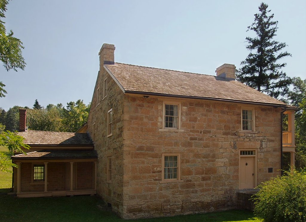
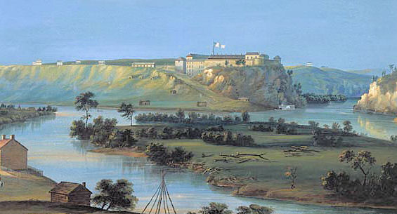
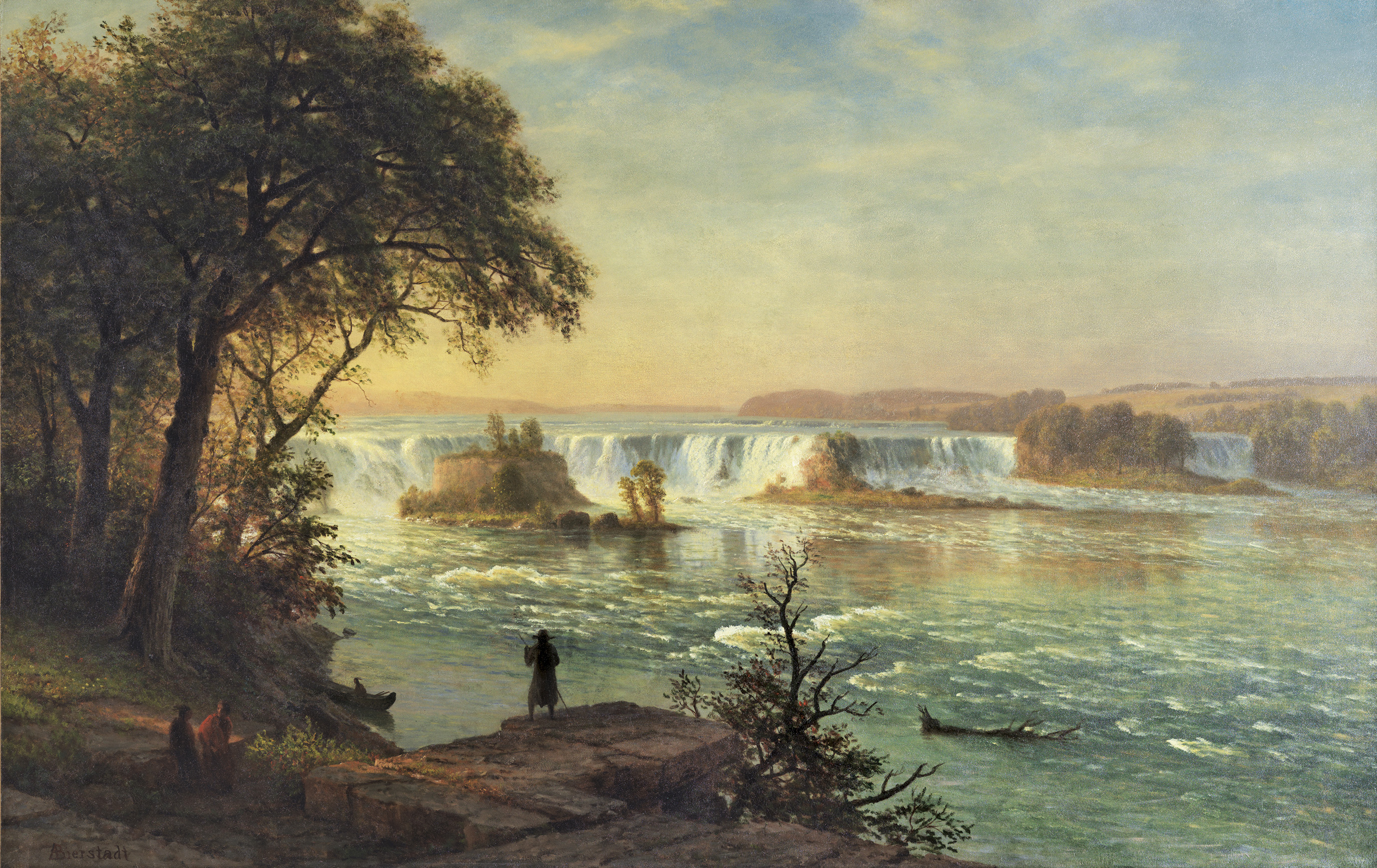
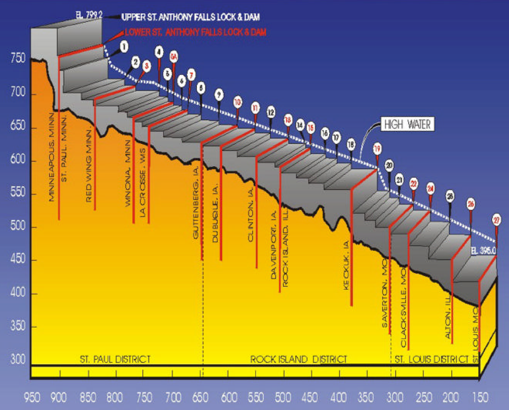
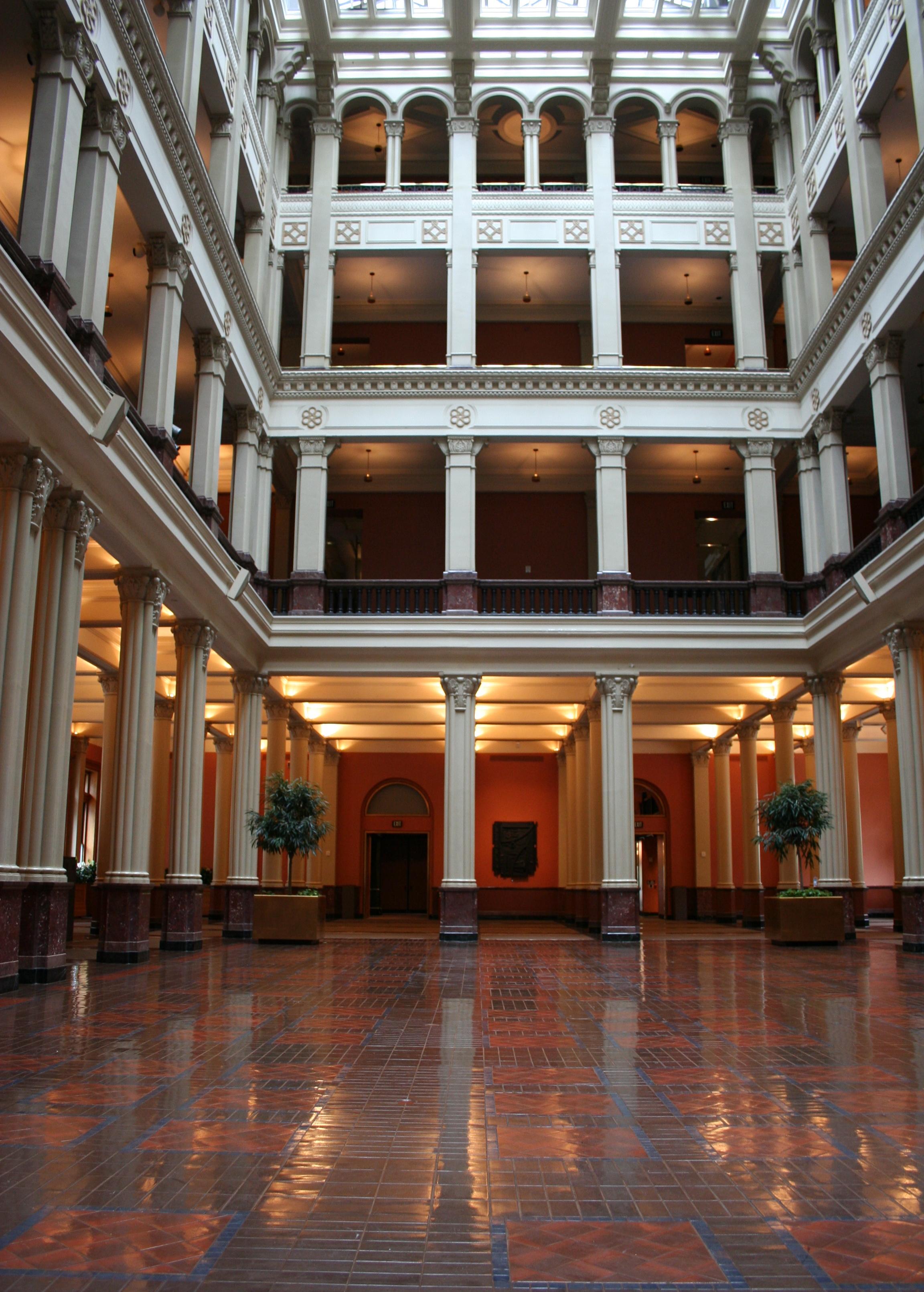
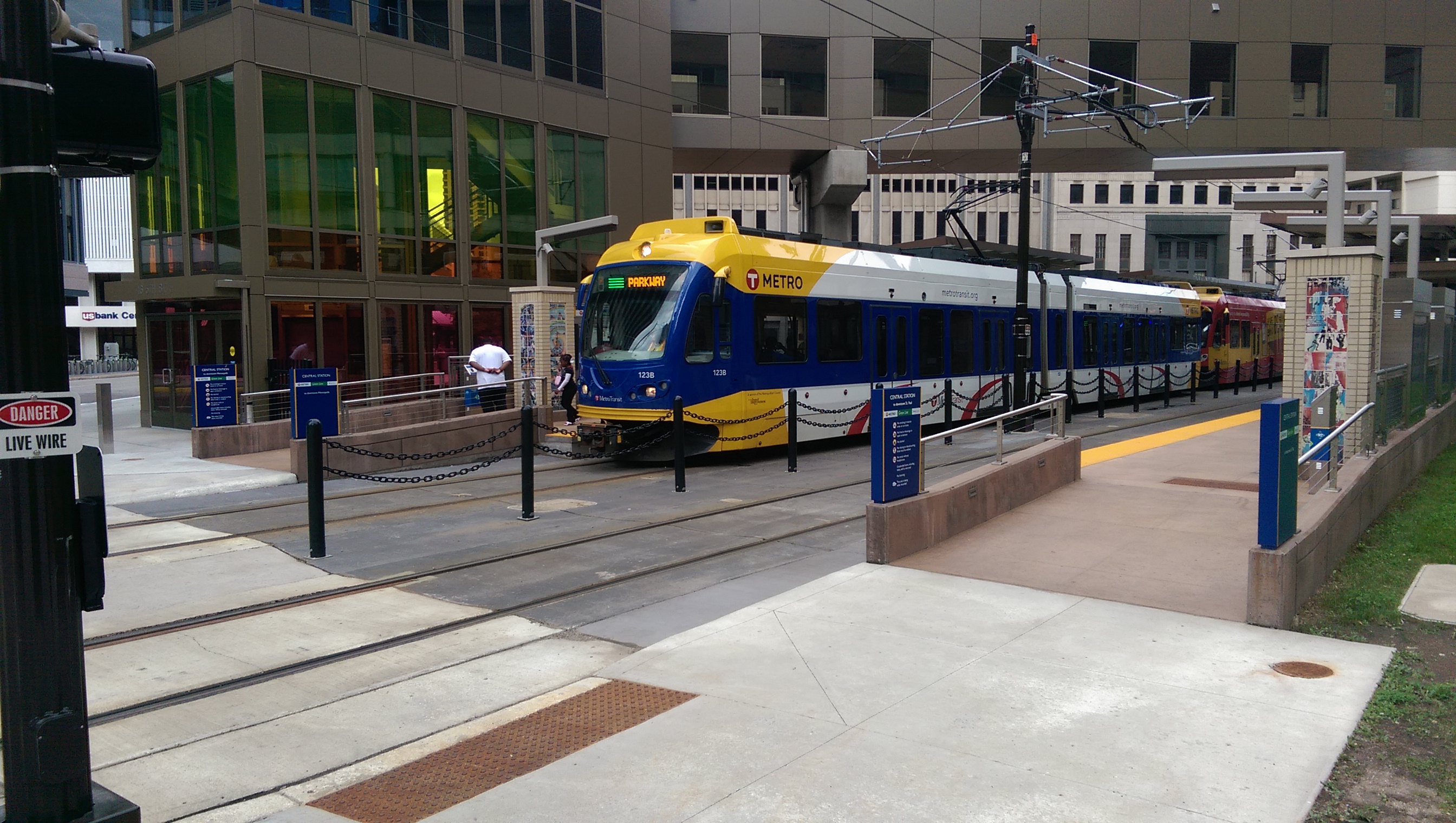
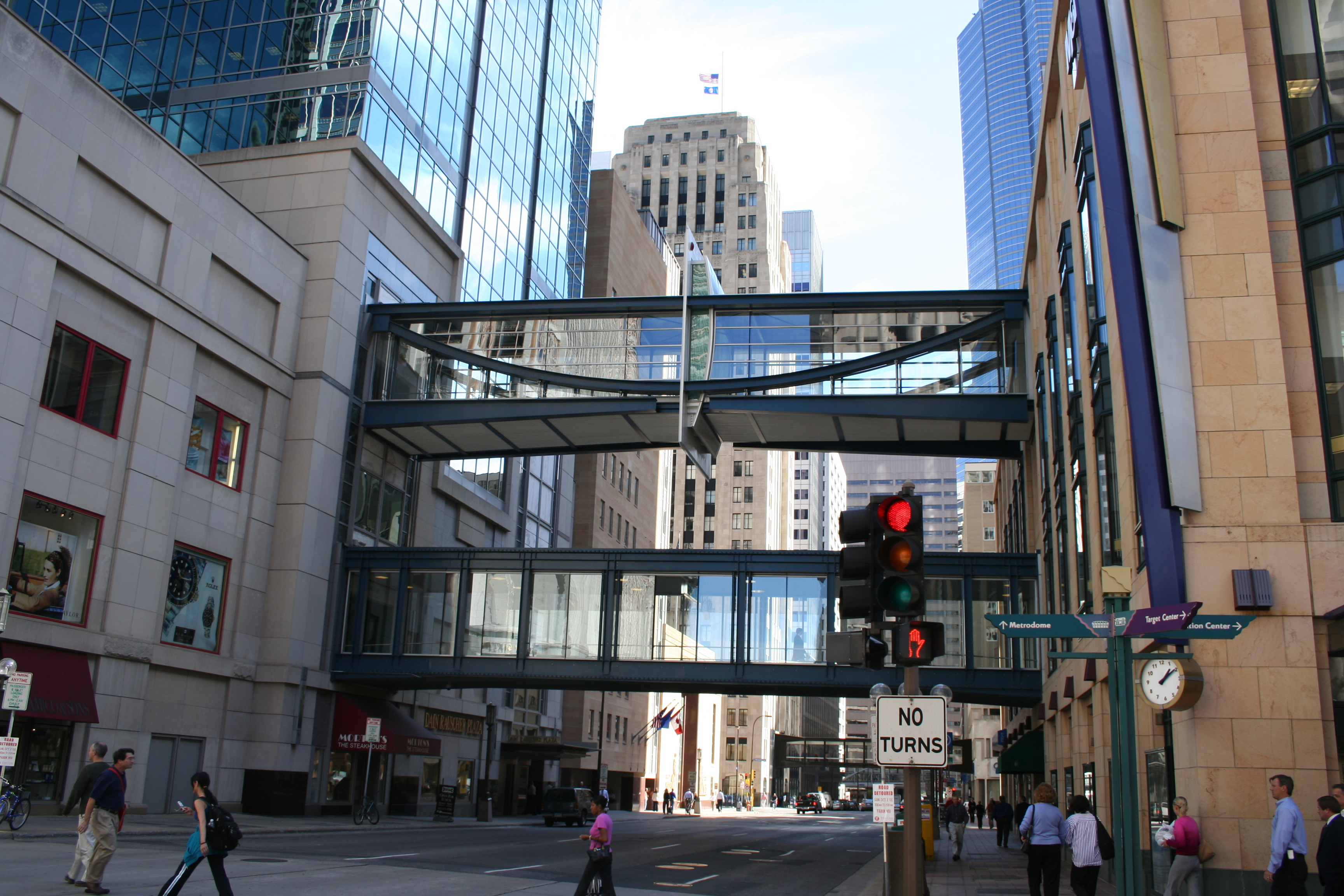