|
Reflections 2016
Series 4
March 23
Mississippi River X: Steamboating, St Louis to St Paul (Hannibal, Galena)
| | Day 13: Transfer to the American Queen in Alton (Continued) As we had known well in advance, because of the construction at the foot of the Gateway Arch, although we were booked to leave "from St Louis", in actuality it was a bus that left from St Louis and brought us up over the Clark Bridge to Alton, on the Illinois side, and upstream. I enjoyed having already been on the landing in Alton earlier, so it was a sort of coming home.
https://ronhaines.files.wordpress.com/2011/02/roadmap-final.jpg
| | | | We've used this "brown" map before, but keep it handy now as a guide for the Upper Mississippi. Last year, we were on the Mississippi from Memphis to its mouth at South Pass, first on the American Queen, then driving, then by private boat to the mouth. This trip we started in Memphis again, drove with many stops to St Louis, will now take the American Queen to St Paul, then will continue by another rental car to the source of the Mississippi at Lake Itasca. There are two side trips as part of this grand excursion, the first was to Kansas City, and the second one, after Lake Itasca, will be a surprise destination even further into northern Minnesota, which will even involve dipping our toe into Canada, so make sure you have your passport with you. | | | | You would think not much was missed in the short distance between St Louis and Alton (see map), but my (very mild) regrets are these. ● Although we did walk down to see the landing in St Louis, it would have been nice to have left from where so many hundreds of steamboats left in the past, including the Arabia. ● We missed completely the Chain of Rocks area. I know we wouldn't have sailed under the bridge I walked over; I assume we would have taken that bypass canal I drove over on the Illinois side. But still. ● Least of all, we missed that newer lock just south of Alton whose construction allowed the removal of the old lock in central Alton, which in turn allowed the construction of that attractive landing just at the Clark Bridge. But there'll be plenty more locks, and anyway, now we've done that stretch vicariously. | | | | As the bus came off the Clark Bridge, we were right at the landing we'd visited when earlier in Alton, which I find comforting, and the American Queen steamboat was waiting for us, and we boarded. We discussed and illustrated the American Queen (AQ) extensively in 2015/8 for the voyage last year, so you can refer back for pictures and explanations and all the facts about it. However, here's a repeat of the deck plan:
http://www.gonext.com/assets/files/AQ_2013_deckplan.pdf
| | | | I said at the time they showed in a video the cabin I'd be in on this trip, and if you do refer back to 2015/8, do a Ctrl-F "Cabin 204", and you'll come to the video. Jump to 3:57 where it shows the door to 204, named the James Madison, described as a Deluxe Bay Window cabin. That window was wonderful, and I still prefer this type of cabin to those described as having an Outside Public Veranda, where there is little or no privacy. Last year, I'd had Cabin 470, named "Henderson", which was a less expensive Inside Single. That was quite cozy, but it was nice this time to have been upgraded to this room with this beautiful, three-sided bay window. It was also nice to be on a low deck, 2, directly adjacent to the beautiful Mark Twain Lounge, where I got good WiFi reception for writing, and to the Purser's Office. I'm also pleased to note that the AQ is a member of Historic Hotels of America. | | | | When we entered any one of the many locks upstream, the stone wall of the lock was VERY CLOSE to the window. The locks filled rapidly, and the view out the window gave the impression that the wall was sinking! But when we reached the top of the wall, there was a public walkway, and you wanted to be careful about your privacy, about workers or the general public seeing more than they should, although I never had any problems. | | | | While it was November in 2014 on the Lower Mississippi, now it was September into October on the Upper Mississippi. November in the South was quite a bit chillier than autumn here in the North, where we had rather good-to-magnificent weather. However, even though this trip was booked as showing "Fall Colors", that was for the gullible, because it was only after the boat ride, while driving in Minnesota, when there was all the tree color you could want—and then some. | | | | I think I have just two new comments about the ship, and then we can get on with the narrative of the trip. I'd loved the calliope music, and this time, too, went to listen to music every time we left a port. But this time they had a gimmick on the day we had no stops, but one that was less touristy than it sounds. One afternoon, everyone who wanted to could play a few notes on the calliope, and then get a certificate, signed by the Captain, about their "accomplishment". All that was required was playing a few notes, so some just did 4-5 in a row. I was bothered by the woman who just pressed the heel of her hand down on some keys—I didn't like that kind of spirit. But what I'd tried to rehearse in advance on my "air keyboard" came off with only a few clunkers: I played the first 18 notes of Scott Joplin's "The Entertainer". It wasn't great, but at least was recognizable. | | | | | | I just dug into the box in the upstairs closet that Beverly and I always called our "memory box", with piles of memorabilia of all sorts, academic, travel, whatever. I knew I had a few of these touristic certificates in there, but was really quite surprised by how many. This is what I found, and what each certificate "certifies", that I've:
2004: traversed the Panama Canal on the Caronia, circumnavigating South America
2004: crossed the equator on the Caronia (actually, once on each side of South America
2004: rounded Cape Horn on the Caronia
2004: overflown the Antarctic Peninsula on Lan Chile, an addition to the Caronia trip
2006: crossed the Arctic Circle on the Deutschland going to Spitsbergen (in German)
2006: ridden the Juno on the Göta Canal from Stockholm to Göteborg
2006: landed on South Georgia Island on the Antarctica trip
2006: set foot on the Antarctic Peninsula
2008: ridden the Blue Train from Pretoria to Cape Town
2008: ridden the Rovos Rail train from Cape town to Dar es Salaam
2009: traversed the Panama Canal on the Queen Victoria, New York to Los Angeles
2011: crossed the equator on the Regatta on the Amazon trip
2012: crossed the Arctic Circle on the Deutschland in Greenland (in German)
2015: and that I'm "duly certified a Calliopist" on the American Queen on the Upper Mississippi
|
| | | | I suppose they're all rather touristy souvenirs, but since I thought I only had 2-3 and not this many, I apparently was not that impressed, and so their value as souvenirs is highly debatable. But they'll go back in the box. | | | | The other point involves dining. I've said in the past I always eat breakfast and lunch in the casual venue of a ship, which on the AQ is the excellent buffet on the Front Porch Café forward on Deck 3, just one deck above me. Traditionally, I've always enjoyed the dinnertime ambience in the formal restaurant, particularly on Cunard. But even last year on the AQ the dinnertime tablemates I had were such fun, that even on that day when I nibbled too much at the Café in advance of dinner, I went to the restaurant anyway and had a cup of tea while the others ate, because of the fun ambience. | | | | This trip not so much. I requested a large table of six or eight, and the first night was put at a table for only four with three thirty-something women. That would have been fine if the conversation had been lively. It started with one woman telling about these marvelous shoes she'd just bought, and went downhill from there. Even the fact that another woman ran a llama farm didn't end up adding much to the conversation. I told the maitre d' after that meal that I'd be eating dinner with my other meals in the Café for the rest of the trip, and I loved it. When I peeked in another time from the windows in the Mark Twain Lounge down to the dining room, I saw that the remaining threesome had been broken up and assigned to other tables. I hope they had fun, because I certainly enjoyed myself in the Café. | | | | This trip on the AQ is my Voyage 53 (Complete, updated list at 2013/7). It is my fourth voyage on a river (1986 Mosel/Moselle River; 1988 Columbia River; 2014 AQ Lower Mississippi), excluding voyages on canals and coastal waters. | | | | We were on board at 2:30, with enough time to unpack. At 4:30 we had a required muster drill, as ever, trying out our life vests. At 5:00 we departed Alton, to the usual calliope music (not by me!). I went up on deck on the starboard side facing Illinois, in hopes of seeing Elsah or anything else familiar, such as the mouth of the Illinois River, but could make out nothing more than highway 100 along that area, largely because it was late in the season and beginning to darken. | | | | Late in the evening, some of us went up on deck to something new for me. In the deep darkness, the AQ had turned on a couple of floodlights, and was using them as headlights to check how close we were to barges or to the shoreline. It was odd to see the lights penetrating nearby wooded areas. At any rate, barges are required to yield to a passenger boat. Then we went through our first lock, which I watched from above, but also from the room to see the wall "drop away"!
http://www.americanqueensteamboatcompany.com/aqsc/media/Design/AQ%20Main%20Itinerary/2015%20Maps/2015-STL-STP-9DAY_1.jpg?width=500&height=500&ext=.jpg
| | | | More precisely than on our "brown map", this is the route map of the AQ between St Louis (Ha! Alton!) and St Paul. We'll be in five states, Missouri, Illinois, Iowa, Wisconsin, Minnesota. Our intermediate stops are Hannibal MO, Clinton IA, Dubuque IA, La Crosse WI, Red Wing MN. Of interest is also Galena, Illinois, across the bridge from Dubuque and a bit south. It's not on the schedule, but we'll cross that bridge—literally—when we come to it. | | | | A person should take such a river trip like this primarily for the fun of being on a boat, in this case, a steamboat. The stops really should be secondary. That is, some places are worth a trip by themselves, such as Vicksburg, Natchez, or Plantation Alley last year. Other river towns, although they might be attractive enough, are just of passing interest. On that basis, if you're going to take just one river trip, the Lower Mississippi has more to offer than here. What's outstanding here? Well, Hannibal with its Mark Twain connection, without a doubt, but that's just an hour's drive out of St Louis, which is how we saw it in 1968. The others are just pleasant towns with 19C architecture. But particularly outstanding for its 19C architecture is Galena, where we don't stop on this trip, so we have to be resourceful. | | | | As you'll recall, the AQ has a couple of buses that follow it and that provide free town tours hop-on, hop-off tours at each stop, following a clearly marked route and route map distributed on board. It's done quite well. But the stops they make in town are always a pretty church, a pretty Victorian mansion, a pretty county courthouse, and so on. Nice enough, but you wouldn't detour on a cross-country road trip just to see this sort of town. On that basis, in some towns I saw nothing wrong in just taking the circle tour for a look-see, and not even getting off the bus. But well see how it goes. | | | | If the Lower Mississippi was the World of Levees, the Upper Mississippi is the World of Locks. There are over two dozen locks, with corresponding dams, in the 1,061 river km (659 river mi) from St Louis to St Paul. These barriers have the affect of changing the waterway from a free-flowing (and free-flooding) river to a series of level basins of water—picture it as one swimming pool after another. This diagram shows how the Upper Mississippi is actually a "stairway of water". Notice now for future reference that, not only is the river at St Paul noticeably higher than downstream, there's a stark rise in the river as it reaches St Anthony Falls in Minneapolis. | | | | Day 14: Hannibal Hannibal has the same simple charm as the other river towns, but stands apart of course for being the location of Mark Twain's boyhood home, making it a major destination. He really is, as we know, Samuel Langhorne Clemens. I'll be using both names. | | | | We last discussed Mark Twain, to my great pleasure, when he was traveling the world and stopped in Australia. It was in 2010/13—do Ctrl-F "Albury" for the section "Mark Twain Speaks Up on Albury". It dealt with the problem of difference in rail gauge in Albury and the need to change trains there in the middle of the night. The quotes I found about Albury are typical Twain. There is also there a link to a picture of Twain's plaque on the Sydney Writers Walk, with another typical quote, this one about Australian history. | | | | We need to first clarify what Hannibal is in the Twain story, and what it isn't. He was not born here, although he was indeed a Missourian. He was born in a tiny place called Florida, Missouri, which I have not visited, but find is located about 45 minutes southwest of Hannibal. The village was not much older than he was, having been founded in 1831 and he having been born late in 1835. He commented that it was "a nearly invisible village" and also said, quite typically "The village contained a hundred people and I increased the population by 1 per cent. It is more than many of the best men in history could have done for a town. However, the village has not fared well, as its population in the 2000 census was 9, and in the 2010 census the village was reported as being uninhabited. However, Mark Twain State Park is there, and includes the Mark Twain Birthplace State Historic Site, so all is not lost. | | | | We will not relate here all of the fascinating Twain biography, which includes shattering family deaths in his later years, his bankruptcy due to a horrific investment, and his necessary constant lecture tours in those years, needed to pay off his debts. We're in Hannibal, and will discuss his early life, starting in Hannibal and into his twenties, when he first became successful as a writer. We'll then jump to two of his residences of his later years, when he wrote his major works, tip-toeing around the tragedies in his later life. | | | | Hannibal had been laid out in 1819 and named after Hannibal, the military strategist from ancient Carthage. In 1839, the family moved to Hannibal which would make him under four years of age at the time. Steamboats docked three times a day, which helped inspire his love for life on the river. But first he worked as a printer's apprentice at a newspaper, and later began to be involved in journalism, including some experience as editor. He left Hannibal in 1853, which would put him at about age 17-18, having lived in Hannibal some 14 years, which is why the house there is described as his boyhood home. | | | | In 1857, when he was 20-21, he went to New Orleans and managed to get himself apprenticed to a steamboat pilot. A river pilot, since he had to know so much of the twists and turns of the river, was paid well, and had more prestige than the captain. He got his pilot's license on 9 April 1859, after two years of apprenticeship, but, contrary to popular belief perhaps, his career as a steamboat pilot was short-lived, about four years, because when the Civil War broke out in April 1861, all traffic on the river was halted. He then went with his brother by stagecoach to Nevada, where his brother had been appointed a territorial official, and he hired Twain as his secretary. While there, he submitted humorous articles to the Virginia City Territorial Enterprise (we discussed Virginia City and the Comstock Lode on the California Trail in 2016/2), and in 1862, he became a reporter, writing serious and humorous pieces as well. | | | | In 1863, Clemens began signing his articles with his pen name, Mark Twain, a Mississippi River phrase which we'll discuss shortly, you may rest assured. He then moved, with his new name, to San Francisco in 1864, where he again worked as a reporter. In 1865, now age 30, he rewrote a tale he had heard in the California gold fields as the short story "The Celebrated Jumping Frog of Calaveras County" (which I clearly remember reading in high school). It became a national sensation, and within months Twain was known around the US, and beyond. | | | | Jumping ahead (frog-like!) to the years of his most famous works, we need to cite two of the many places he lived over the years. While we associate many of his most famous works with Hannibal and the river, it's true that the stories of Tom Sawyer and Huck Finn (and others) are based there, and involve people he knew there, but obviously none of the writing took place there. Any mental image of Twain sitting in Hannibal and writing "Tom Sawyer" or its sequel "Huckleberry Finn" is sorely mistaken. By that period in his life he was long gone from Missouri, except for occasional visits. He'd become a New Englander, and, by extension, a Northeasterner. | | | | He and Olivia (Livy) Langdon, from Elmira NY, were married in 1870 in the Langdon home, and they eventually ended up living in Hartford CT. These two places were where his major works were written, and I've visited both.
https://www.marktwainhouse.org/admin/assets/images/photo_gallery/1308757556-TwainCoverHouse.jpg
| | | | This was Twain's 25-room, Victorian Gothic home in Hartford. At the time, Hartford was a major publishing center, with twelve publishers, and also had the highest per-capita income of any US city. He moved to Hartford, just to the west of downtown, partly to be closer to his publisher, but he also said: Of all the beautiful towns it has been my fortune to see, this is the chief... You do not know what beauty is if you have not been here. He also liked the fact that other authors lived nearby, and—believe it or not—Harriet Beecher Stowe (2016/3) was his next-door neighbor—literally! Her house can also be visited, although I didn't do so at the time. He lived here from 1874 to 1891 and here he wrote, among others, The Adventures of Tom Sawyer, The Adventures of Huckleberry Finn, Life on the Mississippi, The Prince and the Pauper, A Tramp Abroad, The Gilded Age, A Connecticut Yankee in King Arthur's Court. Twain's Connecticut residency would seem to explain why he had a Connecticut Yankee, and not a Missouri Show-Me-Stater, visit King Arthur's court. | | | | But the Clemenses never lost the link to Livy's hometown and family, and they spent many summers in Elmira, which is why I expand Twain from becoming a New Englander to becoming a Northeasterner. Livy's elder sister had inherited from their father a house near Elmira called Quarry Farm (Photo by Lvklock), and the Clemenses summered here for over twenty years—although it didn't literally belong to them, it was their de facto summer home. | | | | Over the summers, he did much of his writing here as well—but not in that house. Because of his cigar-smoking, an octagonal study was built expressly for him in 1874 about 200 meters/yards from the house, with a view he greatly admired:
https://redtreetimes.files.wordpress.com/2009/11/quarry-farm-study.jpg
http://blog.visitmo.com/wp-content/uploads/2010/10/mark-twain-in-quarry-farm-study.jpg
http://www.twainweb.net/gifs/elmira97/e8.gif
| | | | He said, in a private letter: It is the lovliest study you ever saw. It is octagonal, with a peaked roof, each octagon filled with a spacious window, & it sits perched in complete isolation on top of an elevation that commands leag[u]es of valley & city & retreating ranges of distant blue hills. However, in 1952, for purposes of preservation and to protect it from vandalism, the study was moved to the campus of Elmira College (third picture above), where it can be visited today, and where there is an Elmira College Center for Mark Twain Studies. When I visited it, it was described as a gazebo, a designation I always liked and remembered; I've also seen it described as resembling a pilot house on a riverboat, but it seems to be referred to as a study or den now. | | | | Records show that it was during the following summers in Elmira that Twain continued his work on: 1874 "Sawyer"; 1876 "Finn"; 1877 "Pauper"; 1879 more on "Finn"; 1882 "Life on the Mississippi"; 1886 "Yankee". | | | | Mark Twain and his entire family are buried in Woodlawn Cemetery in Elmira, so, of all the places he lived, one has to balance the importance in Twain's life of Hannibal, Hartford, and Elmira. | | | | Origin of the Pen Name His pen name is so well known that I'm sure many people wouldn't be able to give his real name. You may have heard that the pen name comes from a river term he would have been familiar with, and that's right. But there's so much more to it than that, that I had to do more digging. I knew about "Mark" and a lot about "Twain", but just precisely what did the phrase mean to a river boatman? Also, what were the other terms that fit in to the series of expressions such as "quarter less twain"? | | | | To a boater, the depth of the surrounding water is always crucial, and on the fickle Mississippi, which, even today with all the dams and levees, still floods regularly, then recedes again, it was particularly important to know if the steamboat was going to run aground or not, so measurements had to be taken. | | | | Most modern nautical charts worldwide indicate water depth in meters. Of course, what else? This website regularly uses the metric system as well. However, the United States mostly (not completely) continues to use what has been referred to, quite descriptively, as the "US customary system", and so the US Hydrographic Office has always measured water depth in feet, which is one thing, but also in the ancient measurement called fathoms. Probably not too many people in the US could tell you just what a fathom is, so we'll start from scratch. One fathom is 6 feet (about 1.8 meters), and is the basic unit of measurement of nautical depth.
http://oneillseaodyssey.org/wp-content/themes/oneil/images/Lead-line.jpg
| | | | There are modern methods of measuring depth, but in Twain's day, a leadline hung overboard was used, which was a length of rope weighted at the bottom with a lead sinker. Various colored markings on the rope indicated depths. The above picture is just illustrative, but is apparently meant to measure depths at sea, since my information on river depths involves much shorter ropes, only going up to four fathoms, not 20, so use the illustration as a guide, but with the following information, which also involves a terminology that was perhaps unique to the Mississippi. | | | | The lead line used was only 30 ft (9.1 m) long, and had a mark (remember that word!) for 1, 2, 3, or 4 fathoms, which was all that was needed on the river. The person that dropped the lead line into the water was called the leadsman, and the term used was to "heave the lead" and "sing the mark". That's right, in Twain's day, the marks were actually sung, as the steamboat made its way in potentially shallow water. I would love to have heard a leadsman sing out "half one!" or, of course, "mark twain!" As we see, the leadsmen used a jargon specialized to their work, understood by other ship workers but not necessarily by outsiders. | | | | We'll start simply, with round numbers of fathoms, but then give more detail. This is what the leadsman might have sung out about the depth, and what marking was on the rope to indicate that depth. This list goes from bad news to good, as the water gets deeper:
"Mark One [Fathom]" indicates 6 ft (1.8 m), shown by one leather strip
"Mark Twain [Fathoms]", indicates 12 ft (3.7 m), shown by two leather strips
"Mark Ta-Ree [Fathoms]", indicates 18 ft (5.4 m), shown by three leather strips
"Mark Four [Fathoms]", indicates 24 ft (7.3 m), shown by one leather strip with a hole in it
| | | | We immediately note that some specialized language (jargon) is used. The juiciest word is the virtually archaic word "twain" in place of "two", and we'll discuss that below. My guess that "ta-ree" was easier to sing out than "three" and might have been heard more easily. But to the point: Mark One was bad news, indicating shallow water. Mark twain was the first depth that indicated probable smooth sailing ahead, depending on the draft (required depth needed) of the ship. Depths beyond mark twain were better news still. | | | | Now that we know our basics, we can get more details. Just like hours are broken down to quarter-hours and half-hours, so are the fathom measurements used by the rivermen broken down further. Quirky phrases are still used, many appearing backwards from what we'd expect. Less than one fathom was sung as "Half", "Quarter", or "Quarter Less", the last one meaning "Less [than a] Quarter" in quirky, backward language. There were no marks on the rope for these smallest of the fractional measurements. However, above Mark One, all quarters were marked with white cloth, halves with red, three-quarters with black, so an experienced eye could quickly figure out the depth. | | | | Between Mark One and Mark Twain, the quirky readings were "Quarter One", "Half One", and "Quarter Less Twain". Reversing the first two lets them be understood as "One [and a] Quarter", and "One [and a] Half". Just as with telling time, where 1:45 is a "quarter to two", that third reading means, still reversing the words, "Twain Less [a] Quarter", hence "One and Three-Quarters". | | | | The group after Mark Twain is "Quarter Twain", "Half Twain", and "Quarter Less Ta-Ree". Beyond Mark Ta-Ree is "Quarter Ta-Ree", "Half Ta-Ree", and "Quarter Less Four". Anything (happily) deeper than Mark Four was called out as "No Bottom". | | | | Thus Samuel Clemens chose a work phrase he heard all the time as a river pilot, Mark Twain, as his pen name. It is pure coincidence that a "mark" on a rope happens to sound like the male name "Mark", but I'm sure he took that into consideration. Let's just be thankful that he didn't choose as a pen name Mark Ta-Ree! (Or, for that matter, "No Bottom!") | | | | But what about "twain"? People like to use archaic forms because of their quaint nature; think of Eugene O'Neill's "The Iceman Cometh". "Twain" is a virtually archaic form of "two", almost dead, but not quite. Perhaps he chose "mark twain", whose nautical use dates from 1799, because it tended to indicate moving forward into a bright future. | | | | But, to use another archaicism, whence the word "twain"? It comes from the fact that Old English did a lot more with gender than modern English (he, she, it). For instance, it had multiple forms for each number between one and three. As or "two", masculine was "twegen", but feminine and neuter were, in this case, the same, "twa". If this still existed today, we'd be differentiating our "two's", talking about twegen boys, twa girls, and twa trees. (An astute eye will tell you that the system at this point had already started to collapse, since feminine and neuter already doubled up on the same word.) | | | | The feminine and neuter form "twa"--with the W pronounced--lost the W, and altered the vowel, so it's pronounced today TU, though spelled "two". (The W was retained in the related forms "twelve" and "twenty".) The masculine "twegen" lost the G and developed into "twain", but remains as an archaic form used rarely, as in "never the twain shall meet", a phrase first used by Rudyard Kipling in 1892: "East is East, and West is West, and never the twain shall meet." In time gender distinctions broke down, "two" became the leading form used , with "twain" a rare, quaint secondary form with the same meaning. So today we talk instead about two boys, two girls, and two trees. This is, obviously, the simpler of the twain systems. | | | | | | A bit of German for all: The above indicates the Germanic nature of English. Until the 18C, German continued to make the same three-gender distinction: zween, zwo, zwei (TSVÉN, TSVO, TSVAI). Modern German retains only the former neuter form zwei for all purposes. The masculine zween, which, in its pronunciation TSVÉN, so clearly reflects "twain", has disappeared totally. The former feminine form zwo has disappeared, but still clings on for dear life. No, not to indicate things feminine, but as a handy alternate for clarity, say on the phone, where the rhyming pair, zwei and drei, could be confused. In that case, instead of using the familiar eins, zwei, drei, one uses eins, zwo, drei, although zwo clearly sounds archaic. Example: Die Adresse ist hundert zwei.—Hundert drei?—Nein! Hundert zwo!
A further point of interest, probably just to the several German speakers among us: the genitive case for the three forms was zwener, zwoer, zweier. While the first two are gone, the last one still clings on—for all genders—in the rather rare situation where possession is to be shown, but an article is lacking to indicate genitive/possession, so the archaic genitive of the number rises to the task, as in die Namen zweier Freunde / "the names of two friends". It's valid, but carries with it just a soupçon of la-di-da, and so is often paraphrased to appear as it would be for any other number as die Namen von zwei Freunden.
|
| | | | Visiting Hannibal With Twain's riverboat associations, it can't be better to arrive in Hannibal than by steamboat. Find the riverboat landing on this map:
http://www.twainquotes.com/HannibalCemeteries.gif
http://www.twainquotes.com/Steamboats/hannibalstatue.jpg
| | | | It got even better immediately. As the second link shows, there's a small park right at the landing with a most enjoyable statue of "Mark Twain—River Pilot" as the inscription reads. He's shown facing upstream—note the river view--in the direction we are going, and given that he was in his low twenties when he was a pilot, the statue shows an appropriately youthful Twain at the wheel. It was a great way to enter Hannibal. | | | | The Twain Home & Museum is the main thing to see, so I wanted to leave it for last. I took the included hop-on hop-off bus tour the AQ always provides, as it passed through the levee gate and looped around town, although I didn't hop off, just got oriented. It stopped at the usual church, "historic main street" (which I'd walk down later), and the typical things you'd expect in a small riverside town. It also went south of town to the Mark Twain Cave, which appears in his stories, but I just looked from the outside. I then let the bus start its second loop, and got off (see map) at the iconic Tom & Huck Statue. Here Tom & Huck, about 12-14 years of age, are strolling along together in bronze (Photo by Ched). Since the statue lies interestingly at the head of Main Street, it shows the two boys looking down the length of the street. Erected in 1926 and owned and maintained by the museum, it is one of the earliest known statues erected to honor fictional characters. | | | | The Mark Twain Boyhood Home & Museum is on the north side of Hill Street at Main (see map). When we were there in 1968, Hill Street had traffic, which was distracting. Now, the eastern half of that block is a pedestrian area, paved in brick, since there are properties on the south side of the street that are now included as part of the museum. So now the museum complex fills the block up to the Tom & Huck Statue, as well as both sides of Hill Street for that short stretch. It's also amusing to think that John Clemens settled his family at a point in town so close to the river, given that his son became a river pilot. | | | | The next stop is to swing around onto Hill Street to get the most iconic view of all. While you are trying to look at the boyhood home (Photo by Andrew Balet), your eyes are compulsively drawn next to the house to the most famous wooden fence in the world, certainly the most famous whitewashed one, Tom Sawyer's fence. It's most likely a replica, but who cares? Click to read the sign, but also note the handsome brick street paving. However, as with all older buildings like this, the streetscape is surely different. In the day, there would have been similar houses all along the street, where today there's a garden, leading to the museum entrance and the stone museum in back.
http://cdn8.openculture.com/wp-content/uploads/2015/05/21234717/Sawyer-3.jpg
http://previews.123rf.com/images/alzam/alzam1206/alzam120600093/14011881-USA-CIRCA-1972-A-Stamp-printed-in-USA-shows-the-painting-Tom-Sawyer-by-Norman-Rockwell-1894-1978-Ame-Stock-Photo.jpg
| | | | But how iconic can you get? The first link above is to a Norman Rockwell painting of the famous Tom Sawyer fence we just saw, and the second shows that the Rockwell painting was even made into a 1972 US postage stamp. Click on each one in turn to analyze how close Rockwell came to the reality on Hill Street when he visited it, and then how close the stamp engraver came to Rockwell. | | | | The AQ arranges for all entry fees to be included, so you just have to tell them you're from the AQ, and walk right in. The museum has all sorts of Twain memorabilia, such as his clothes and first editions, but I'll report on just one I enjoyed seeing. It's a huge plaster model 2-3 meters/yards wide of a proposed statue of a seated Twain and all his characters posed in two long arcs on either side. It wasn't just the Hannibal crowd, including Becky Thatcher, but included the Connecticut Yankee and others. I wish I'd thought to look and see if the Jumping Frog was among them, but I didn't. In any case, it was proposed that it be erected during the Depression, and the million dollars needed could not be raised, so it was never built. But even the plaster model is impressive.
http://1.bp.blogspot.com/_2QQq0K2UtEo/TaTIaAwo_FI/AAAAAAAACgw/evXavsF0Kfg/s640/P4070047.JPG
| | | | When you exit the museum, you're still within the museum complex in that city block, but now facing North Street and the Tom & Huck statue. Located here is the replica of the Huckleberry Finn house, the home of Twain's childhood friend, Tom Blankenship. The original house was very ramshackle, if not a hovel, with other buildings located on the block, whereas the reconstruction is a rather attractive, though very modest, freestanding cabin. While Twain himself was surely the model for Tom Sawyer, Twain has said that Tom Blankenship was the model for Huck Finn. Tom's mother seems to have died when he was young, leaving Tom and his six sisters with his father Woodson Blankenship, who was a drunkard, as is Huck's. The family apparently dressed in ragged, charitable hand-me-downs, and Tom—and certainly his sisters--didn't go to school because there were no public schools at the time, and the father couldn't afford private tuition. Thus, Tom Blankenship had plenty of time on his hands, and little supervision, to engage in various "adventures". Twain mentions Tom Blankenship in his autobiography: In Huckleberry Finn I have drawn Tom Blankenship exactly as he was. He was ignorant, unwashed, insufficiently fed; but he had as good a heart as ever any boy had. His liberties were totally unrestricted. He was the only really independent person—boy or man—in the community, and by consequence he was tranquilly and continuously happy and envied by the rest of us. And as his society was forbidden us by our parents the prohibition trebled and quadrupled its value, and therefore we sought and got more of his society than any other boy's. | | | | From here you enter the boyhood home from a side entrance, and the revelation of what has been done is surprising and pleasurable. In so many travel situations, it's BEING THERE that's fulfilling. For instance, just being in the Pony Express Barn was a thrill, with no real horses, and no real riders present. That's similar with so many houses. I didn't feel it necessary to tour the Truman house in Independence, for example, since it was a typical, comfortable early 20C house. Just being at the house where the Trumans lived served the purpose of the visit. Similarly, in the Twain house, I doubt that many, perhaps none, of the furnishings were original, since it was a long time between when the family lived there and it became a museum. So the interior is pleasant, and nicely furnished, but not necessarily Clemens-specific. However, what the curators have so cleverly done is to put full-size white plaster statues in several rooms, and included appropriate quotes of Twain's on a board behind him. This is particularly appropriate here, since it was his memories of this house when he was in Hartford and Elmira that inspired him. | | | | This is the sitting room (Photo by Ched) in the front of the house—you can see the inside of the front door and two windows you saw from the exterior; so narrow is the house. The furnishings give the right atmosphere, but the statue of Twain looking at the room, perhaps from afar, while you do the same is just perfect. Click to read the marvelous quote on the board. I liked the quote so much that I wrote it down verbatim to use it before I found this picture online that shows it so well. And what he says is similar in nature to what Thomas Wolfe's "You Can't Go Home Again". One more like this—the next room is the dining room (Photo by Ched). Click to read this equally insightful quote. | | | | Leaving the house, one walks across Hill Street to see the buildings on the other side. On the right is the Becky Thatcher house (Photo by Andrew Balet), the home of the woman who inspired the character for Tom Sawyer's sweetheart. Click to read the sign on the left. We know who inspired Tom and Huck, and we also know who inspired Becky.
http://cdn.loc.gov/service/pnp/cph/3a10000/3a15000/3a15200/3a15269r.jpg
| | | | It was Laura Hawkins, who was two years younger than Clemens. The two were childhood playmates, classmates, and sweethearts. He portrayed her as Becky Thatcher in the Sawyer and Finn books, and used her real name for one of the principal characters in The Gilded Age. He visited with her in Hannibal in 1902 and in Redding, Connecticut, in 1908—I don't know which of those meetings is shown in the above picture. While Huck is missing, we are looking here at Tom and Becky. | | | | To the left of the Thatcher house, is this view (Photo by Andrew Balet), over toward Main Street, where we get (click) an inkling of the typical 19C architecture along the main streets of Hannibal and other river towns. The large white building facing Main Street is the historic Grant's Drug Store, which is part of the museum for preservation purposes, but which is not Twain-related. But definitely Twain-related is the closer white building, the law offices of Twain's father, John M Clemens, Justice of the Peace, so the elder Clemens only had to cross the street to go to work. | | | | We'll now reflect back to our discussion of the Pony Express (2016/1) and to our reference there to this very office. In the 1840s, Hannibal was Missouri's third largest city and St Joseph was the second largest. To connect them, the Hannibal & St Joseph Railroad was organized in 1846 in the office of John Clemens, the very one we're looking at. It reached the furthest west of any railroad of the period (until the transcontinental railroad was built), and therefore was used to deliver mail to the Pony Express in St Joe, on a regular basis, and not only during that first-day emergency. | | | | | | I want to quickly mention an incident here, then quickly erase it from my mind. On the AQ, as on all ships, a daily bulletin is distributed giving the schedule for the next day as well as information on the next day's port. We boarded in Alton, I glanced at what it said about Hannibal. Along with the obvious, it made the bold statement that the Pony Express left from Hannibal. (!!!) I immediately went to the nearby purser's office and made a complaint about inaccurate information, and that no Pony Express horse ever saw the likes of Hannibal, and he said he'd look into it and (hopefully) take care of it. (Don't hold your breath.) It just goes to prove that junk prepared for tourists can sometimes be just that—junk—so travelers should inform themselves as well as possible on their own. |
| | | | While in Hannibal I learned about the Norman Rockwell paintings of the Tom & Huck novels, and that they were on display at the branch on the Museum two blocks south on Main, at Center Street (see map). The former Sonnenberg Building, so typical of Main Street architecture, is now the Mark Twain Museum Gallery:
http://979kickfm.com/files/2013/08/photo-630x472.jpg
| | | | Just look at that glorious cornice! The Gallery fills all two floors of the period building, and most of it has the type of artifacts you'd expect in a Twain museum. I particularly remember a German movie poster advertising Die Abenteuer des Tom Sawyer / The Adventures of Tom Sawyer. But the best reason to go is to see the Norman Rockwell Gallery upstairs. | | | | In the 1930s, new special editions of both the Tom Sawyer and Huck Finn books were to be published, and it was decided that Norman Rockwell should be commissioned to do paintings to be used as illustrations for the books. It would seem that that was a genius move—what better combination to portray Americana than Twain and Rockwell. While other illustrators had worked on similar books, Rockwell was, at the time, the only one to actually visit Hannibal to see the source material. I think all travelers would agree—being there makes all the difference. When describing his Hannibal experience, Rockwell said that: The whole town of Hannibal lives in the memories of Tom and Huck--or rather, of Mark Twain. He depicted things just as they actually were. The Tom Sawyer story is truly autobiographical in the sense that even if Mark Twain didn't personally do some of the things attributed to Tom, he understood exactly how Tom would have done them. That made my task as illustrator an exceptionally interesting one.
http://farm3.static.flickr.com/2531/3694770814_4da5a998df_o.jpg
http://cdn8.openculture.com/wp-content/uploads/2015/05/21235054/Huck-Finn-Rockwell.jpg
| | | | There is an entire series of original Norman Rockwell Tom & Huck oil paintings in the Norman Rockwell Gallery of the museum in this building. Without doubt the most famous one—it was chosen for the postage stamp—was of the fence, as we saw above. Above are two others I've selected. I'll let the museum curator tell you about some details, particularly of the picture of Tom in the window (carefully inspect the two versions), in this YouTube video (1:22) of the Norman Rockwell paintings. | | | | It's time to get back to the boat, but let's first look at this panorama (click) of Hannibal and the Mississippi looking north (Photo by Kelly Martin), the direction in which we're headed. You won't find any of the places we've discussed—I've tried—but I will point out four things. ● Spanning the river is the Mark Twain Memorial Bridge. ● You see the train tracks along the river. The US has lost so much passenger rail infrastructure. You can't take a train from Hannibal to St Joseph any more, or anywhere else, for that matter. ● Now walk to the left across the tracks under the trees. Just above that reddish building in the foreground is the gray levee gate, now open. The levee itself is covered with brown grass and runs diagonally across the picture. ● Then look to the top until you see the Mark Twain Memorial Lighthouse on the river bluffs, built in 1935 on the centennial of Twain's birth. This is Cardiff Hill, a favorite play area of Tom, Huck, and others. Actually, it's aligned with Main Street and the Tom & Huck Statue and has 244 steps leading up to the top. Perhaps the statue illustrates the boys coming down from playing on the hill. I understand there are panoramic views—like we're seeing here—and I believe it does light up, but I also suspect it's mostly ceremonial in nature. | | | | Leaving Hannibal, we heard the calliope play. Then, as we approached the bridge (Photo by Andrew Balet), we watched them lower both black smokestacks into a forward position into their cradles—always a spectacular sight. | | | | Day 15: Steamboating On the ocean, a day with no stops is called a day "at sea", which is slightly odd, since you're at sea all the time, but it's the term that is used (of course on a transatlantic crossing, it's all gloriously "at sea"). Here, it's called a day "steamboating", ditto. This was also the day I became a calliopist (!?), as did others.
http://www.americanqueensteamboatcompany.com/aqsc/media/Design/AQ%20Main%20Itinerary/2016%20Maps/2016-MISS-GRAND-VOYAGE-3WKS_500x500.jpg?width=500&height=500&ext=.jpg
https://www.americantrails.org/quad/images/QCmap600.jpg
| | | | We will continue to stick, as needed, to our brown map and our route map. The first map here is temporary, and just to illustrate the second one. We were in Hannibal yesterday and will be in Clinton tomorrow, but we'll pass the Quad Cities (find them) in the night tonight on the way to Clinton, and they're worth discussing, even though it's not a stop. Again, the AQ said nary a word, so you have to do your own research to be knowledgeable. | | | | The second map shows the Quad Cities region. Why should there be such a large urban cluster here? The reason is invisible today, but it has everything to do with riverboats, including steamboats. Originally there were 21 km (14 mi) of dangerous waters here. There was a series of finger-like rock projections coming out of either bank, causing rapids that were difficult to traverse. It cannot be a coincidence that the largest island in the Mississippi is here, originally called Rock Island (now Arsenal Island), which gave its name to one of the Quad Cities. In addition, the difficult stretch of water was called the Rock Island Rapids. | | | | Over time, the settled area grew because of the rapids. Boat crews needed rest areas before running the rapids. Places were needed to hire expert pilots to guide the ships. Worst of all, when the river was low, places were needed where goods could be offloaded to be brought by wagon to a point beyond the rapids. But today, the rapids—and the activities surrounding them—are gone because of two local locks and dams. But it's an interesting riverboat-based basis for an urban area to develop. | | | | After the Civil War, the region began to feel unified and have a common identity. By WWI, Davenport on the Iowa side and Rock Island and Moline on the Illinois side began calling themselves the Tri-Cities. During the 1930s, East Moline IL had grown enough to be given equal status, and the term Quad Cities came about, three on one side, one on the other. But when Bettendorf IA eventually even passed East Moline in size, some tried to alter the name to Quint Cities, but the name Quad Cities was firmly rooted, and that name never stuck. So we have another of the anomalies that we live with: there are five Quad Cities, two in Iowa and three in Illinois. And the Quad Cities Metropolitan Area is the largest metropolitan area on the river between our two end stops, St Louis and St Paul. And the AQ glides by it—and the former rapids—during the dead of night. | | | | Day 16: Clinton When Clinton was laid out in 1836, it was named New York. If that had lasted, there'd be two places by that name, with the similar confusion between Portland, Maine and its larger namesake, Portland, Oregon. But DeWitt Clinton was the popular two-time governor of New York and one of the driving forces behind the Erie Canal (places in NY State bear his name, such as the Clinton neighborhood of Manhattan and Clinton Avenue in Brooklyn), and in 1855, it was decided to change the name of the Iowa town to Clinton. In addition, the town of DeWitt was founded, also in Clinton County, about a half-hour west of Clinton.
| | | | I took the hop-on tour (and didn't hop off) through the pleasant, attractive river town. The tour also crossed over the bridge to Fulton IL to see an area celebrating its Dutch heritage. Clinton is a nice little town, but if I were driving cross-country, I don't think I'd make a detour to here. | | | | Day 17: Dubuque & Galena Our stop today is in Dubuque (rhymes with "da cuke" [!!]), Iowa, which looks a bit interesting, but is not as interesting to me as Galena, Illinois, across the river. Although I've driven in western Illinois, and did stop in Nauvoo (just south of Burlington IA), from which the Mormons decamped on the Mormon Trail to Utah, I never made it to Galena, which was also the home of General and President US Grant. When planning this trip, I had found out that southbound, the AQ has time for a special bus trip from Dubuque to Galena—for a fee--but not now on our northbound trip. But we want to see Galena. Will we beat the system? As Minnesotans like to say, "you betcha".
http://pics2.city-data.com/city/maps2/cm7617.png
| | | | This map shows how US-20, unmarked at first, comes in from the west, runs through Dubuque, crosses over the Julien Dubuque Bridge to Illinois, then runs down to Galena (the red line is broken on the map). Galena is not directly on the Mississippi, but is on the Galena River (shown), and historically, the heavy steamboat traffic reached it that way. We also see a state line, making this a tri-state area, and how southern Dubuque, including downtown, faces Illinois, but northern Dubuque faces Wisconsin. | | | | Julien Dubuque, from Québec (the French influence came all the way up the river valley) founded Dubuque in 1785 as the first permanent non-native settler. In 1788, he received permission from the Spanish government—they were then in charge—and the local Fox tribe of Native Americans, to mine the area's rich lead deposits. I normally wouldn't bring that up, except the whole area was rich in lead or, which, as you may know, is called galena, so the name of that town shows how it made its wealth in the past. We might as well look at some galena in its crystalline form (Photo by Rob Lavinsky). Galena is technically galena sulfide, PbS; the word is Latin, but otherwise of unknown origin. | | | | So how do we get to go to Galena, and still have time to see Dubuque? It took some work, but was doable. It all boils down to Enterprise car rentals, that I've been using exclusively the last couple of years. Their rates and service are good, they give you points, but best of all, they pick you up and drop you off. We had the larger rental Memphis/KC, and we'll have another larger one in St Paul to see Minnesota. What we need in Dubuque is a quickie one-day (actually, half-day) rental, with pickup and dropoff. And on top of it, I had more than the 650 Enterprise points needed, to this short rental would be free. | | | | I arranged the rental months in advance, then used my cell phone to call Dubuque out of Clinton the day before to confirm the early-morning pickup. Time was of the essence. The AQ was in town only five hours, from 8 to 3, and we had to be back on board at 2:30, giving us 6 ½ hours at the very maximum—I didn't want to even come close to that. I'd checked with the purser that it was indeed OK to debark before the shuttle buses leave. I had a quick early breakfast in the Café (this never would have worked with table service in the dining room) and was outside by 8:00. After they called back to re-reconfirm, a car arrived in a few minutes and picked me up. | | | | I learned later that they used to have an office downtown, but nowadays, they're located in an office park some 10-15 minutes away on the west side of town, but that's still doable. I have found this outstanding map of Dubuque, which we'll call the red map. Keep it handy for the duration of the day:
https://www.topoquest.com/map.php?lat=42.49972&lon=-90.66846&datum=nad83&zoom=4&map=auto&coord=d&mode=zoomin&size=l
| | | | What you see as Dubuque Harbor is just a local marina. The AQ was docked just to the right of the number 30, and this entire area is called the Port of Dubuque. You see how close downtown is, as well as the Julien Dubuque Bridge with US-20. (It would appear that the former rail station is just south of the bridge—more lost infrastructure.) He got us onto US-20, we zipped out to the office park by 8:30, I rented the car, and was back on this map in no time, zipping past downtown and the AQ and crossing the bridge into Illinois (once again!). From downtown to Galena took about 20 minutes. | | | | Galena has been mined in the Galena area by Native Americans for over a thousand years. These deposits made Galena the site of the first major mineral rush in the US. The first American settlers arrived in 1821, and seven years later, the population was about 10,000. By the 1830s, Galena's population was greater than that of the Chicago of that era, and Galena had great expectations for the future. It was in the mid-19C that Galena's present appearance was established, and for just the same reasons that established the appearance of the original Laclede's Landing in St Louis—fire. There was a string of fires in the 1850s which led the city to prohibit new construction using wood, resulting in a downtown today that is mostly brick and stone, giving it its signature appearance. | | | | So it was lead mining, here inland, that established the town, which explains why Galena didn't pop up, like so many towns, on the banks of the Mississippi. Still, the Galena River allowed Galena to become the largest steamboat hub on the Mississippi north of St Louis. But with erosion, the Galena River began to silt up and could no longer receive steamboats. There was further decline in the 1860s as railroads succeeded steamboats—a story similar to the one we heard about the Eads Bridge and steamboats in St Louis. Also, Galena depended too much on the one product, lead, and when lead prices, as well as the demand for lead, fell, Galena suffered as well, and its population dropped from 14,000 in the mid-19C to about only 3400 today. By the 1880s, Galena's decline was such that other river ports took its place, most notably, as we've just seen, Dubuque across the river. The floods of the Galena River also led to the decline, which continued through the 1950s, when many downtown buildings were dilapidated and boarded up. | | | | Then came along the modern historic preservation movement and the founding of the National Register of Historic Places in 1966. But Galena beat that by one year, becoming one of the first cities in Illinois to pass historic preservation legislation and to establish a historic district in 1965. In 1969 the Galena Historic District was added to the Register. Incredibly, it includes 85% of the structures in Galena. | | | | For us to best understand the layout of Galena, the huge size of the historic district in this small town, and for us to best visit it, I've dug up three maps.
http://www.granthome.com/Galena-map-300dpi-RGB-copy2.gif
| | | | This, the first map, is useful for general orientation, but is not the greatest (click), and the street names are hard to read, so I'll point them out. Start with the Galena River, which divides the town. The bridge you see crossing it is for US-20, down which we arrive from Dubuque from the upper left.
Downtown Galena is to the left of the river, which is the basis for the graceful curves on the main streets.
Nearest the river, Water and Commerce Streets are of secondary importance, and are on bottom land that reaches up to the next street, Main Street.
Rising in tiers up the steep hill after Main Street are two others, Beech and Prospect Streets. These last three streets are primary, and give downtown its character. To the northwest of Prospect spreads out a large residential area.
The area to the right of the river is smaller and more spread out, but has some significant structures, notably the Grant House.
| | | | While I've seen two references saying the District covers either 800 or 1000 structures, I found online, in the City of Galena website, the Galena Historic District Database, with an interactive map, that lists, as we speak, no fewer than 1,462 structures in the District. Now that we're oriented, take a look at our second map:
https://www.ruskinarc.com/galena/all/map
| | | | The number of structures in the District is overwhelming. Now that we know where downtown is, we can see the large residential area beyond that upper street, Prospect Street. The concentration of 19C homes beyond Prospect Street, as well as on the south side of the river, was labeled, in the nomination document for the National Register, as "astonishing." | | | | Click on the plus sign to move closer for further inspection—three times should do well. Note the intense concentration of listed buildings on both sides of curving Main Street, obviously the best show in town. Keeping in mind the streets tiered above Main Street, note that some side streets, notably Green and Washington, are so steep that they're closed to traffic, and consist instead of stairways for pedestrians. | | | | But it's this third map will get us around town best, since it's simplified enough for doing so, so keep it handy. Let's go back to that US-20 bridge across the river and look upstream on the Galena River (Photo by IvoShandor). What do we see? A sea of brick, flowing up the hillside, with church steeples. We can judge where Prospect Street, the top one, is because that large building with the green-roofed tower, a former school we'll look at later, is located on it. And an amazing thing is in this picture, hidden in plain sight. Do you see what I mean? Hint: it's green and long. | | | | It's that long, grass covered levee here on the Galena River—we've always seen them only on the Mississippi. And it gets better. At the front end of the levee, there's a brown wall and an aqua-colored gate with cars passing through. It's the pair of levee gates (Photo by IvoShandor), seen here in detail. Now look again at both these pictures, and if you have a romantic imagination, you see a medieval city wall protecting a town, and the city gate letting travelers through. Actually, it works just the same way. | | | | Now back on our map, let's leave the bridge and enter downtown. We're on Main Street, and Branch takes off uphill (Prospect is unfortunately not shown), but they're all high enough not to need protection from flooding. Therefore, we find we're driving through the levee gate right before Water Street (and later, Commerce) split off, since these are the streets needing flood protection. Since we're here, let's drive up Water Street to see two buildings, both shown on the map. First we come to the handsome Galena Customs House & US Post Office (Photo by IvoShandor), serving those functions in that sequence historically. It was built in 1858 as the Galena Customs House, and later became a Post Office, which it still is. It's said to be the longest-operating PO in the US. The building is an outstanding example of Federal style architecture. Click to inspect that cornice (!!), those chimneys, and the window and door detail. In the back is the levee, with people enjoying a stroll on it on the left. | | | | We cut over to Commerce Street (see map) to go see the Old Market House (Photo by Teemu008), now operating as the Galena Welcome Center for visitors. It was built in 1846 in Greek Revival style, not with a large Greek portico, but with Ionic columns on both sides (click). It served as an enclosed public farmer's market, but had offices for the city hall upstairs. This is one of three structures within the Historic District that nevertheless has its own listing on the National Register. | | | | We now back up to the fork with Main Street, since it's one way north (Bench is one-way south) for the pièce de résistance, where most of the red-brick structures are in the Federal style, as was the PO. We first come across the DeSoto House hotel (Photo by Chris Light at en.wikipedia), shown here in a winter scene, looking towards the nearby levee. It opened in 1855 and is reported to be the oldest operating hotel in Illinois. Abraham Lincoln once spoke from the hotel balcony—again, this IS Illinois—and other guests were Theodore Roosevelt, William Jennings Bryan, and Ralph Waldo Emerson. | | | | Now looking up Main Street (Photo by [WT-shared] Ethajek), we see that the commercial buildings around the curve present an unusual architectural harmony. As I look at that beautiful white building with a proud cornice and oriel windows with wide bays, I get suspicious that that façade might be cast iron, as we discussed in St Louis. Maybe, maybe not. | | | | Further up Main, and now looking back (Photo by Chris Light), we see the different levels, a church up on Beech Street, and a building way up on Prospect. | | | | Even our little map shows, further up on Main a one-block diagonal street going up to Beech. Its name is—Diagonal Street. (!) At its lower end is the 1832 Dowling House (Photo by Chris Light), the oldest in Galena. Its style is strikingly different from what we've been seeing. I understand it was built within the grounds of the stockade originally constructed here, which could possibly explain why Diagonal Street is out of line with the others.
https://cdn2.gbot.me/photos/m1/Cw/1284669815/Galena_IL_Turner_Hall_07_-Turner_Hall-3000000016156-500x375.jpg
| | | | As we turn and go down Bench Street, we find, along with residences, more churches and fraternal buildings. One I distinctly remember was the above very handsome Turner Hall, for which I can offer a story.
In late 18C Berlin, educator Friedrich Ludwig Jahn started a physical education movement, not only for self-improvement, but as training against potential Napoleonic invasion. By the early 19C, the Turnverein movement was well under way: turnen means "to do gymnastics" and a Verein is a club, so a Turnverein is best described as a Gymnastics Club. The movement became international, particularly with the emigration of Germans, and Turnvereine were established in a number of American cities, including Galena. In 1848 in Cincinnati OH, the organization now called the American Turners was founded. In German a Turner (plural unchanged) is a gymnast, so the name could have been American Gymnasts, but apparently a German connection was still desired, so an English plural S was added to the German word.
The Galena Turnverein was founded in 1851, and activities became much more social than gymnastic. After the Civil War, the club wanted larger quarters, and Galena wanted a meeting hall, and in 1875 Turner Hall was built. In the early 20C, it became the Turner Opera House for theatrical and musical events. But about the time of WWII, the city acquired the building, and it became a community hall, but deteriorated. In 1960 the Galena Art Theatre was formed, and in 1970 it formed the Save Turner Hall Fund for restoration. Although the city still has to subsidize the building, it's once again a beautiful building on a splendid site on Bench Street.
| | | | We move uphill to Prospect Street (Photo by IvoShandor), lined with multiple intact 19C mansions. It's mostly residential, with the exception, at its far (dead) end, of that large building and clock tower we saw earlier. It once was Galena High School, but has now been recycled as a residential condominium (Photo by Djngsf). It has a nice view, and, as we saw from the river, views of it are equally impressive. | | | | Backtracking a block or two on Prospect, we come to Green Street (Photo by IvoShandor), which, you'll recall, is one of those steep streets that now consists of pedestrian staircases. First, this is the general view of town from Prospect Street, including from the former High School. But what a view down Green Street! Click to see Beach Street crossing; when you get to Main, you'll recognize a corner of the DeSoto House on the left; behind that, between Commerce and Water, is the Custom House & PO on the right, then comes the levee, the Galena River, and a view of the pedestrian bridge to Grant Park on the other side we saw on our map, where we'll be shortly. Marvelous! | | | | We need to drive out of downtown to cross the bridge again to the other side of Galena. At the corner of 3rd Street (see map) we find the Washburne House (Photo by IvoShandor), the second of the three properties here that has its own listing on the National Register. Elihu Benjamin Washburne was a prominent resident who had the house built in 1844-1845, in the Greek Revival style, which is even more obviously so than the Old Market, since these fluted Doric columns are part of a two-story porch. | | | | Our map shows us it's just a zig-zag over to Park Avenue, where the (unfortunately) disused Illinois Central Railway Depot (Photo by Teemu008) faces Depot Park on the river. It's a handsome building nevertheless, facing the disused riverside tracks. | | | | It's only about three blocks up Bouthillier Street to the former home of General & President Ulysses S Grant and his wife, Julia (Photo by IvoShandor), which is the third and finally building with its own listing on the Register. This is the side view, from the road, showing the view of town the Grants had across the river. This is the front view (Photo by Teemu008), down the entry walk. Curiously, including Grant, Galena was the home to nine Civil War generals.
https://travelgardeneat.files.wordpress.com/2012/10/galena-grant-park-10_20_12.jpg
| | | | Finally, we backtrack to Park Avenue (see map) to stop at Grant Park, which has an even closer view of downtown. We park the car and hike up the hill to see the statue of US Grant (above, and on map). It's a rather good likeness—click to read the inscription on the front: "Grant our Citizen". | | | | | | I've talked recently about visiting the graves of Presidents LB Johnson, Eisenhower, and Truman. There's no reason to look for a presidential grave in Galena, since the Grants are neighbors of mine in Manhattan, further up the Hudson. I live in Lower Manhattan, and the Grants are on Riverside Drive at about 123rd Street, at the General Grant National Memorial. I visited it as a teenager on one of my exploratory urban hikes around Manhattan, and it was, I'm quite sure, the first presidential grave I ever visited. So don't ask me who's buried in Grant's Tomb. |
| | | | Well, we saw Galena, but still have Dubuque, and the clock is ticking until the AQ sails, so off we go back over the bridge to get off in downtown Dubuque (check out the red map again). I had the map the AQ gives out of where the shuttle bus stops, so did a quick look-see downtown as though from a bus window. Two places I'll mention are the Grand Opera House (Photo by Dirk Hansen), which now houses general theater and concerts. It dates from 1890 and in 2015 was marking its 125th anniversary. Another place I liked was the 1891 Dubuque County Courthouse (Photo by FluffyGryphon), a spectacular wedding cake of a building. It's worth mentioning here the importance of county court houses in American cities. We talked about the Court House as the focal point of Oxford, Mississippi when visiting Ole Miss, and the significance of Vicksburg Court House during that battle. We'll also point one out later in Minnesota.
| | | | But the major thing I wanted to see in Dubuque was its petite funicular. It's of great interest, not the least for its story. It's commonly called either the Fenelon Place Elevator or the 4th Street Elevator, since it connects the two. Officially, it's run by the Fenelon Place Elevator Company since the impetus to build it started there and the ticket office is at the top, but for our purposes, I'm going to call it the Fenelon Place/4th Street Funicular (FP/4S Funicular), and you'll see why below. While we'll be sticking to our red map, just for the moment, take a quick look at this map:
http://2.bp.blogspot.com/-wnRbgq8psHQ/VXj1uJPspdI/AAAAAAACYAA/ilyhJ86UhEA/s640/Map-Dubuque%252C%2BGalena%2B%2526%2BJo%2BDaviess%2BCounty-Dubuque%252C%2BIA.tiff
| | | | On this map you can see 4th Street in the center coming to an abrupt end, then the short Fenelon Place taking its place. Now that you know where to look, go back to the red map, find 4th Street in red (at the number 608), then some black dots, then a street running a couple of blocks. But what I like most about this map is that it show elevations, and you can see why a funicular is needed up the river bluffs. | | | | We've talked all along about river bluffs on the Mississippi, looking down from Kaskaskia, how Elsah was in a tiny valley in the bluffs, and elsewhere. But the bluffs aren't always right on the water, as you can see in Dubuque. The downtown is laid out on some bottomland, leaving the river bluffs interrupting the streetscape on the west side of downtown—but offering spectacular views downward and across the Mississippi. | | | | You may well know the difference between elevators and funiculars, but make sure you understand the importance of counterweights. A building elevator is not dragged upward as dead weight by some struggling winch at the top. From a car at the bottom, the cable runs to the top over an engine's wheel assembly, then goes down to counterweights on the side of the shaft. When the car rises, the weights fall, meaning the wheel assembly and engine aren't picking anything up at all, just overcoming inertia and friction as it moves the cable, and compensating for the varying weight of the passengers in the cars. | | | | It's possible to put an elevator on an angle up a hill, but such an inclined elevator needs tracks for the car to ride on. There are still counterweights that come down between the tracks as the car goes up. A funicular, on the other hand is quite clever, since two cars are used, which act as counterweights to each other! One car goes up when the other comes down. Usually, a single track is used, which splits into two tracks at the halfway point so the cars can pass each other. We last discussed both inclined elevators and funiculars in Québec. For a review, go to 2013/6 and do a Ctrl-F "Funiculaire du" to read about the Funiculaire du Vieux-Québec, which has a good illustration of two side-by-side inclined elevators as opposed to a one-track funicular. | | | | Most funiculars are large operations built by governments or big companies. The unusual thing about the FP/4S Funicular is that it was built by and for just one person, so therein MUST lie a tale, and indeed there does. It involves JK Graves, a former mayor and former State Senator who became a banker. He lived on top of the bluffs and worked at the bottom. It took him a half hour each way to drive his buggy around the bluffs to downtown, which he did four times a day, including going home for lunch. This was particularly frustrating, since the bank and his house were only 2½ blocks apart. | | | | So he acquired a franchise for the right-of-way and had an engineer build him a cable car that was definitely an inclined elevator. There was a simple wooden building at the top with a coal-fired steam engine boiler and winch. There was a single wooden car, hauled up and down on two rails by a hemp rope. (!!) It ran for the first time on 25 July 1882. He had it run by his gardener (!!) four times a day for his commute to and from work. If this isn't simplistically charming (for a wealthy man!) to establish a cable car, I don't know what is. | | | | Obviously, it drew attention after a while, and neighbors began meeting him at the upper station, asking for rides. Then, days before its second anniversary in 1884, the elevator was destroyed by fire. So Graves had it promptly rebuilt, but, remembering the interest of his neighbors, he decided to open it to the public. He charged five cents a ride. | | | | But less than a decade later, in 1893, the elevator burned again. But this was the time of the financial Panic of 1893, and this time, Graves couldn't afford to rebuild. Since people had come to depend on it for work, school, and shopping, ten neighbors got together and formed the Fenelon Place Elevator Company, and Graves gave them the franchise for the right-of-way. But this group did their homework. They traveled to the 1893 Columbian Exposition in Chicago for new ideas. They came back with plans to turn it into a funicular that year to run on the footprint of the 1882 inclined elevator, now with the standard two cars, and appropriate new rails with a bypass. They now had a streetcar motor to run it, replacing steam power with electric power. And they brought back steel cable to haul the cars up and down, replacing the hemp rope, which, in the fires, had burned, sending the original single car crashing to the bottom, also destroying the tiny lower station. | | | | The company's ownership by the neighbors remained that way almost for another decade. But by 1912, CB Trewin, who had built a house next door in 1897, became the sole stockholder after buying up the shares from the others as they either passed away or moved away. The Trewin family is still the owner and operator. In 1977, the cars were completely rebuilt and the original gear drive was replaced by a modern gear box with a DC motor. | | | | Thus the funicular has always been a neighborhood affair. But the name of the company retains the original term "elevator", because that's what Graves built, although it's been a funicular far longer than an inclined elevator. It also retains the name of Fenelon Place, whereas it's really less for neighbors today and more for visitors to downtown Dubuque, who will be coming, like we will, from 4th Street. That's why I prefer to refer to it as the FP/4S Funicular. | | | | It's listed on the National Register for Historic Places. Its petite size is reflected in the fact that its tracks are narrow gauge, at 914 mm (3 ft). The track length is 90 m (296 ft). The company says its angle is 106°, although I'd rather say that the slope of the hillside is the complement of that, 74°. They also say that height of the upper station above the lower station is 58 m (189 ft), and claim that the funicular is the world's shortest, steepest scenic railway, although other funiculars also make that claim. | | | | We've stopped at a couple of places the shuttle bus stops at, and the funicular is one as well, although I'd done a lot of reading on it in advance, and would have gone here in any case. There is street parking at the end of 4th Street, right at the lower station (Photo by Jesster79) of the funicular, and the first impression is that of petiteness, almost a toy-like quality. Usually funiculars have both ends staffed. Here, the lower station is about the size of a bus shelter, with no one in sight, except for a woman passenger who arrives at the same time as we do. It's so low tech, that a sign inside says to pull the rope from the ceiling to ring the bell, so they know to send down a car.
http://media-cdn.tripadvisor.com/media/photo-s/05/13/10/71/fenelon-place-elevator.jpg
http://www.jtbell.net/transit/images/Dubuque/LowerStationSide.jpg
| | | | I know there are plenty of visitors up top, so the cars are running constantly (first picture), but I wasn't about to miss the opportunity of using the bell, so I pulled the cord. Some pleasures in life are truly simple. And momentarily, a car arrived for us (second picture), and we were underway (no attribution). Click to inspect the tracks, the bypass area, and the more formidable upper station.
https://kimberlyah.files.wordpress.com/2012/06/dsc_0086.jpg
| | | | This view down from the upper station is revealing. Click to judge the size of the petite cars. Note at the bottom of the picture the cables between BOTH tracks, each set pulling one car. Then note how, further downhill, there are only cables in the left-hand track for the lower car, which is acting as the counterweight of the closer one. Not only does 4th Street stretch out in front of us, but in the upper left, you'll see the "wedding-cake" courthouse we visited earlier. Finally, the car arrives at the viewing terrace (Photo by Jesster79). Getting off, you pay your fare at the ticket booth. You can pay one-way, then walk down, or do as probably most do, get a round-trip ticket at this point. | | | | And the views from the bluffs! We'll show three (all three photos by Dirk). Let's start with this wide panorama. First we see 4th Street as a dividing line below. To the left (north), beyond the court house, is Wisconsin across the river. To the right (south), beyond the Port of Dubuque, is the bridge to Illinois. Then let's look at this detail to the north. Click to see how nicely the court house stands out, and then note the nearby "Julien Inn". Actually, this is Hotel Julien, named for Julien Dubuque. It's taken several forms since its founding in 1839, but has housed Abraham Lincoln, William "Buffalo Bill" Cody, and Mark Twain. Finally, we have this detail to the south, where the Port of Dubuque and the bridge stand out more clearly, with the Hotel Julien just to the left of the Port.
| | | | When it's time to leave, another advantage of being a solo traveler presents itself. There's a line to go down, but from up front, they call out there's space for one more in the car that's about to leave, so I get to go immediately. I ride down with a group of schoolgirls from China, with a local chaperon, and we have a bit of a chat. | | | | You may have had enough of the funicular, but there's a rather good YouTube video showing a ride on the cable car. The first part show the complete ride, and you can see how the cables work between the tracks. It does run 6:11, so see how much of it you want to watch. | | | | We're done. It's a quick zip back to US-20, and then out to the office park to return the car. We get our ride back right to the Port of Dubuque, and we have easily an hour to spare, even before the 2:30 boarding time. Boarding the AQ from up front, you have to walk through the Mark Twain Lounge, and I help myself to one of the chocolate-chip cookies always available in a big dish, just to reward myself for proving that you can have your cake and eat it, too. And for beating the system: Illegitimi non carborundum. | | | | I'm sure most people have come across that expression, which has a very clever "translation", and does have meaning, although there is no basis whatsoever for that meaning. The phrase sure looks like it's Latin, and so, as long as one gets the in-joke, one can sound pompous seemingly quoting a classical language to make one's point, but then laugh along with everyone else. It's not Latin. It's mock-Latin, fake-Latin, pseudo-Latin, but it gets its point across. As you probably know, it's standardly "translated" into English as "Don't let the bastards grind you down", and is therefore useful advice. It was contrived early in WWII, c 1939, by British army intelligence, and soon an American general adopted it as his motto, and it spread from there. | | | | But (1) we deal with language here, even fake language, and (2) we've already talked about one mineral, galena, actually galena sulfide (PbS), so it's appropriate we talk about two other minerals now, and even make a reference to a different classical language, Sanskrit. (!?) | | | | We start with a word that has some claim to genuineness, the Late Latin word illegitimus, "illegitimate [person]". The plural is indeed illegitimi "the illegitimate". But while that form has become standard in this expression, when the Brits made it up they did use a bit more Latin grammar (I'm no Latinist, but Wikipedia helps here). They actually used the form illegitimīs, and that long I plus S puts it into the ablative case, which, I'm informed, adds the meaning of "by", in other words "by the illegitimate". So far, so good, but the rest is much more fun. | | | | The word carborundum looks SO Latin, right? Not in the least. It's used standardly as an alternate name of the compound silicon carbide, SiC, now our second mineral of the day, which is used as an industrial abrasive material for grinding, sandblasting, even for sandpaper. It's rare in nature, and most of it sold is synthetic. So this non-Latin word brings to mind the idea of grinding. Put the Latin negative non in front, and non carborundum just "wants" to mean "not grinding", doesn't it?. So we have "by the illegitimate" + "not grinding", and that "yields" the standard English "translation". That's really a priceless bit of artistry. | | | | But there's more. Just as "kleenex" and "xerox" were company names that became generic, "carborundum" started out as an 1892 registered trademark of the Carborundum Company of Pennsylvania, and has now become generic as well. But where did the company get that word? They made it up! It's a combination of "carbon" plus "corundum". OK, but, what's corundum? It's our third mineral, and a very interesting one. Corundum is a crystalline form of aluminum oxide Al2O3, but more interestingly, it's one of the naturally transparent minerals, which makes it particularly appropriate to be used for gems. | | | | Corundum by itself is clear and transparent. But with different impurities, corundum takes on different colors. With one exception, all gemstones made from corundum are called sapphires. By far the most common trace element is iron, which makes the corundum blue, and hence most sapphires are blue, and by default, the word implies that color. But titanium yields a yellow tint, and the gem is then called a yellow sapphire; chromium makes a purple sapphire; copper makes an orange sapphire; magnesium makes a green sapphire. And the exception? Chromium yields a red tint, and in this case, and entirely different word is used. A gemstone made of red-tinted corundum is called a ruby. | | | | This, on the other hand, brings up a very basic point about perception and language. If you give something its own word, you will perceive it as different. If we called a ruby, as with the others above, a red sapphire, we'd no longer consider it a separate category of gemstone. | | | | Tamil is a language of India and Sri Lanka, and the word "corundum" derives from the Tamil word kurundam, which means, not too surprisingly, ruby. In turn, that Tamil word derives from Sanskrit kuruvinda. And that ain't Latin. | | | | Day 18: La Crosse Our stop today is La Crosse WI, a nice enough little town. The AQ docked here at Riverside Park (Photo by Crosscountrycpjon), where this view is downstream, to the south--but we had a much brighter and sunnier autumn day. I took the Hop-on Hop-off shuttle bus, but didn't hop off, since it was the usual type of circuit; an auto museum, a church, another museum, an 1850s Victorian mansion, a garden. As with Clinton, on a cross-country tour, I wouldn't take a detour here.
| | | | The name, though, has to draw interest. Apparently the game of lacrosse was devised by Native Americans across eastern North America many centuries ago, and was quite different, sometimes involving hundreds of players. It was documented in the 17C by French priests in Canada, who thought the stick used resembled a crosier, the stylized hooked staff carried by a bishop, which in French is a crosse. You may feel that word even resembles the word "crosier". The game was NOT invented here in La Crosse. However, when Lt Zebulon Pike (of Pike's Peak fame) mounted an expedition to the area in 1805, he observed Native Americans playing lacrosse here, and commented in his journal about the French name of the ball game. He recorded the location's name as Prairie de La Crosse, which by the 1850s was shortened to La Crosse. | | | | En route to our stop tomorrow in Red Wing, we pass during the night through Lake Pepin, which the AQ keeps silent about, like in the Quad Cities. Lake Pepin is considered an actual lake, but in reality, it's just a rather wide spot in the Mississippi. Though we didn't see it on the AQ at night, I've driven along it in the past, and our train going home will pass right along it. By eye, Lake Pepin is about the last fifth of the distance from La Crosse to, Red Wing, and it ends there. Take a look (click):
http://karthlake.com/wp-content/uploads/2013/07/Lake-Pepin-map.jpg
| | | | Find Red Wing at its north end, then Wabasha MN just beyond its south end. It's definitely the widest naturally occurring part of the Mississippi, and is called the largest "lake" on the river, but you decide if you want to believe it's a lake or not. What I do find interesting is why it's there, and the guilty party is the Chippewa River on the right. It's apparently brought down quite a lot of sediment out of Wisconsin, and has formed over time its own delta within the Mississippi, just north of Wabasha, severely restricting the Mississippi's width and flow and causing this backup of water (see map). But I ask again, is it a lake or a wide spot? | | | | Day 19: Red Wing The city of Red Wing was named after the Sioux chief Red Wing. I've always assumed the early 20C popular song "Red Wing", about an "Indian maid", was named after the city, or else the chief, or both. However, the connection is tenuous. I find that the city and the chief MAY have been an influence on the name of the song, but that's not certain. Another possibility—I'm just guessing—is that, as the independently-named song became popular, people jumped to conclusions and just assumed as I did that there was a connection. This is not unusual in language. In any case, the song remains another reflection on the North American romanticization of the Native American population, as further evidenced in Longfellow's characters Minnehaha and Hiawatha. | | | | The song "Red Wing" was written in 1907 and enjoyed considerable popularity. This is the sheet music cover, and Kerry Mills took credit for the music (but see below). | | | | We have from YouTube an original 1908 duet recording (2:35) of "Red Wing". Jump to where it starts at 0:20. | | | | But just as "Goin' Home" was adapted from Antonín Dvořák's New World Symphony (2015/17), "Red Wing" was adapted from Robert Schumann. In 1848, Schumann composed, for his three daughters, a collection of 43 short piano works which he called Album für die Jugend (Album for the Young). #10 in that group Schumann called Fröhlicher Landmann, von der Arbeit zurückkehrend ([The] Happy Farmer, Returning from Work). This is, on YouTube (0:48) Schumann's Fröhlicher Landmann. | | | | | | This also brings to mind Alexander Borodin (ba.ra.DYIN). By far, his most popular work is the Polovtsian Dances. Though they are from his opera Prince Igor, they are often performed as a solo concert piece. Anyone hearing one section, the "Gliding Dance of the Maidens", immediately recognizes the popular song "Stranger in Paradise" from the 1953 musical Kismet. But I'm now surprised to find out that ALL the music from Kismet was adapted from Borodin's works. |
| | | | There's something else about Red Wing I wanted to discuss that I prepared some illustrations for. But I've just found out some sad news about it. Still, it's something I wanted to see and did see, so let's talk about it anyway. | | | | I've developed an interest in pottery, almost exclusively from watching Antiques Roadshow on TV, both the American and British versions. They discuss pottery from many countries, but it's the American pottery that I've gotten to notice. If you look up the names, you find dozens and dozens of potteries that have made both art pottery, dishware, and stoneware over the decades, but as it turns out, so many of them have been gone for a long time. | | | | One of the names I've gotten to recognize is the Rookwood Pottery of Cincinnati, which was one of the most famous American potteries in the early 20C. Much of their work was hand-painted by artists. But they seem to have been active only between 1900 and 1967. Weller Pottery of Ohio is another name you hear often, but they operated only between 1872 and 1948. An academic connection can be seen in the Newcomb College Pottery of Louisiana, where students worked on Arts & Crafts pottery. But it produced only from 1895 to 1940. | | | | There were many others, but the only pottery workshop I physically visited personally was Stangl Pottery of Flemington NJ. I remember years ago my family would drive more than once across the Hudson to see what was available at Stangl, including hand-painted dinnerware. I still have a set of small, palm-sized Stangl plates I use that I got there. But I now see that Stangl closed in 1978. | | | | Speaking of the smaller potteries, we come to Red Wing Pottery. It was initially set up in Red Wing in 1861 and produced American stoneware, pottery, and dinnerware. It closed in 1967 after a horrendous labor dispute but reopened in 1996 with limited production. Apparently, it's just been squeaking through in recent decades, but when we were there, the bus shuttle made two stops in the northern part of town to visit the current Red Wing Pottery. There were two buildings with museum-like displays, showrooms, demonstrations, and a sales office for the sale of current items. | | | | I just read online today that the current owner and his wife took over in 2013, but lately has been embroiled in trademark disputes and what he calls general harassment from community members, since there still seems to be an undercurrent of local resentment from the 1967 strike. Others seem to deny this. Despite a profitable year of sales, the owner apparently decided to close down last Christmas Eve the large facility we visited in early October. There was great interest from visitors, who flocked to the showrooms when I was there. There is also widespread disappointment in Red Wing, as the Red Wing Visitors Bureau reported. It seems so sad. Fortunately, the owners plan to continue making some products for Red Wing Stoneware and Red Wing Pottery, so perhaps the name will continue. Hopefully it will all be resolved. | | | | Historical Red Wing pottery is still valued by collectors, and is available on Ebay. This is a stoneware crock (Photo by the Minnesota Historical Society) made by Red Wing Potteries—you surely notice the insignia of the red wing.
http://www.go-star.com/antiquing/red-wing-stoneware1.gif
http://wisconsinpottery.org/RedWing/RedWing2002show/dinner/redwing-dinnerware1.jpg
| | | | The first picture shows a collection of such stoneware, much utilitarian, others less so. The second picture (click) illustrates dinnerware patterns by Red Wing. You can see by the dates that many of these are historical styles.
http://www.tias.com/stores/tipp/pictures/te1465a.jpg
http://www.oldandsold.com/articles01/redwing3.jpg
https://s-media-cache-ak0.pinimg.com/736x/77/d0/ae/77d0aee22265b8cd6cc779a81e93edb1.jpg
| | | | I particularly appreciate art pottery, such as these examples. And I love the yellow rooster casserole dish. I hope the pottery makes another comeback. | | | | As I said, I did hop off the bus shuttle at the pottery, and the tour through downtown was really very nice. I got off downtown and walked around the main intersection, which offered a handsome cityscape. From there it was just a bit downhill to the attractive 1904 Red Wing Station (Photo by McGhiever), next to which the AQ was docked. Not only was it a pleasure to see, but it's the first "live" station we saw since Gateway Station in St Louis---so many others formerly had service, such as in Galena. Amtrak's Empire Builder stops here—we'll be doing so later and will be seeing it again, just like in Independence and in Alton. It's the first stop out of St Paul on the way to Chicago. | | | | Then came the last night on the AQ. During the night, on the way to St Paul, we passed the St Croix River forming the border between Wisconsin and Minnesota (see brown map). We didn't see it, but at the end of the Minnesota stay, we will stop by to visit the confluence. We continued beyond that upriver to arrive at Lambert's Landing in St Paul early in the morning. It was an early rising and breakfast, since we had to be off by 8:00. My side of the ship faced the Landing, and it was very dark and rather uninviting at that early hour, despite the many street lights in the park along the landing. It being early Sunday morning, there was almost no traffic or pedestrians. While most passengers were waiting for buses to the airport, the few of us who were pedestrians could disembark at will. Shepard Road runs along the river, and I crossed that and went under the rail underpass up Sibley Street, just two blocks to St Paul Union Depot, from which we'll be going home later. In St Paul, rail 'n' sail are pleasantly adjacent, just as in Red Wing. The depot is on 4th Street, and four blocks west on 4th is our chosen hotel. You know: location, location, location. | | | |
| |
|
|
|


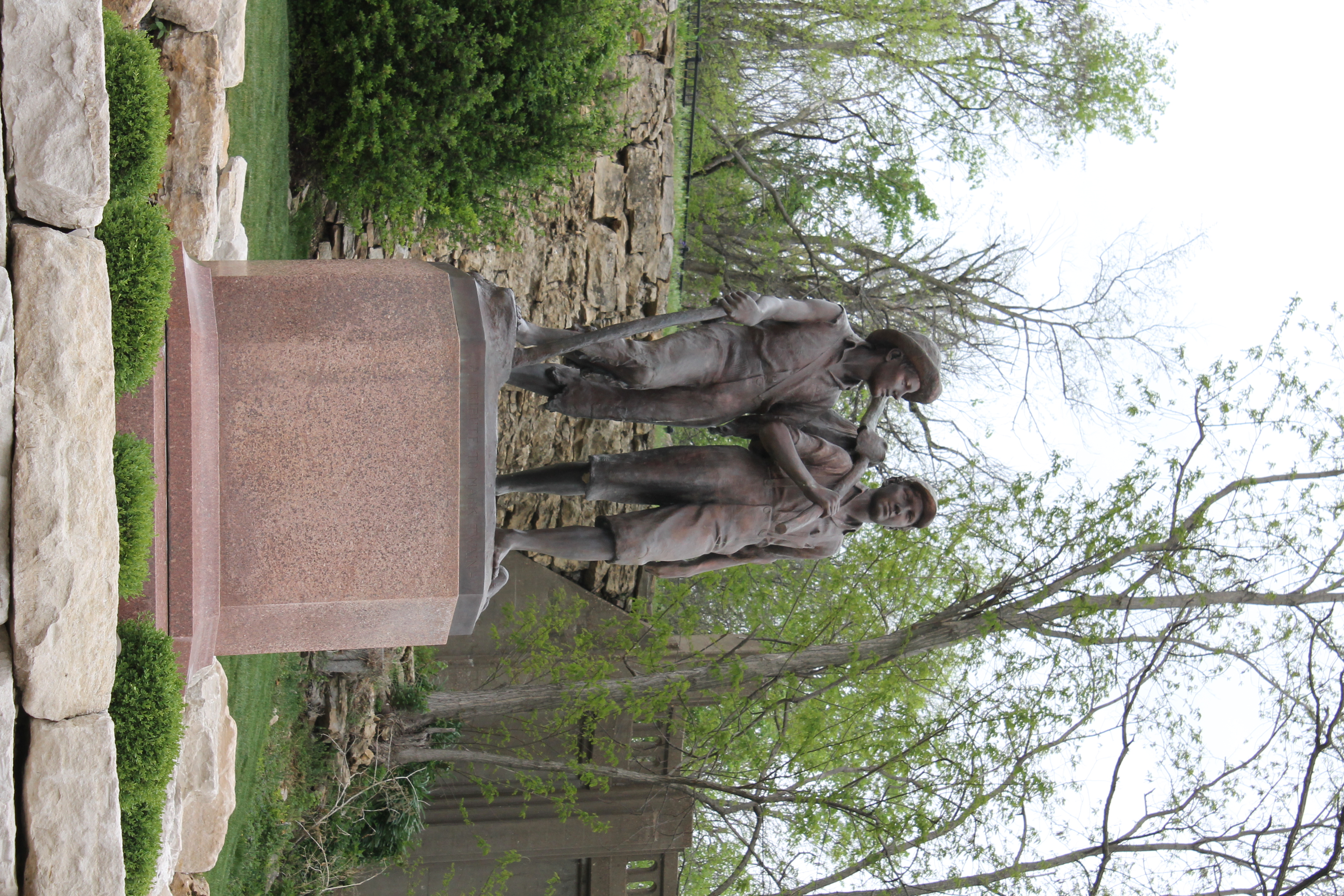
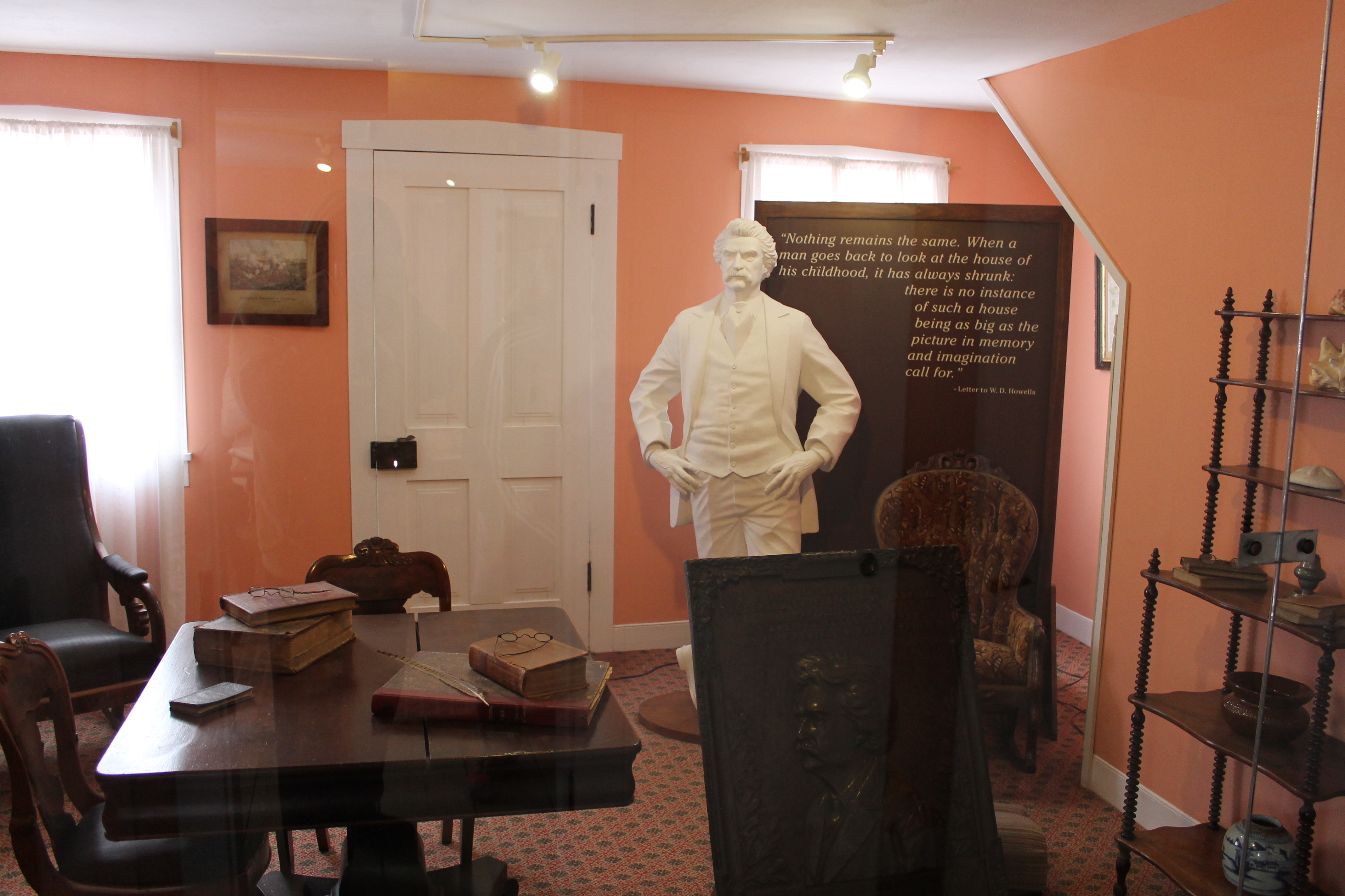
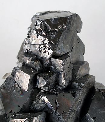
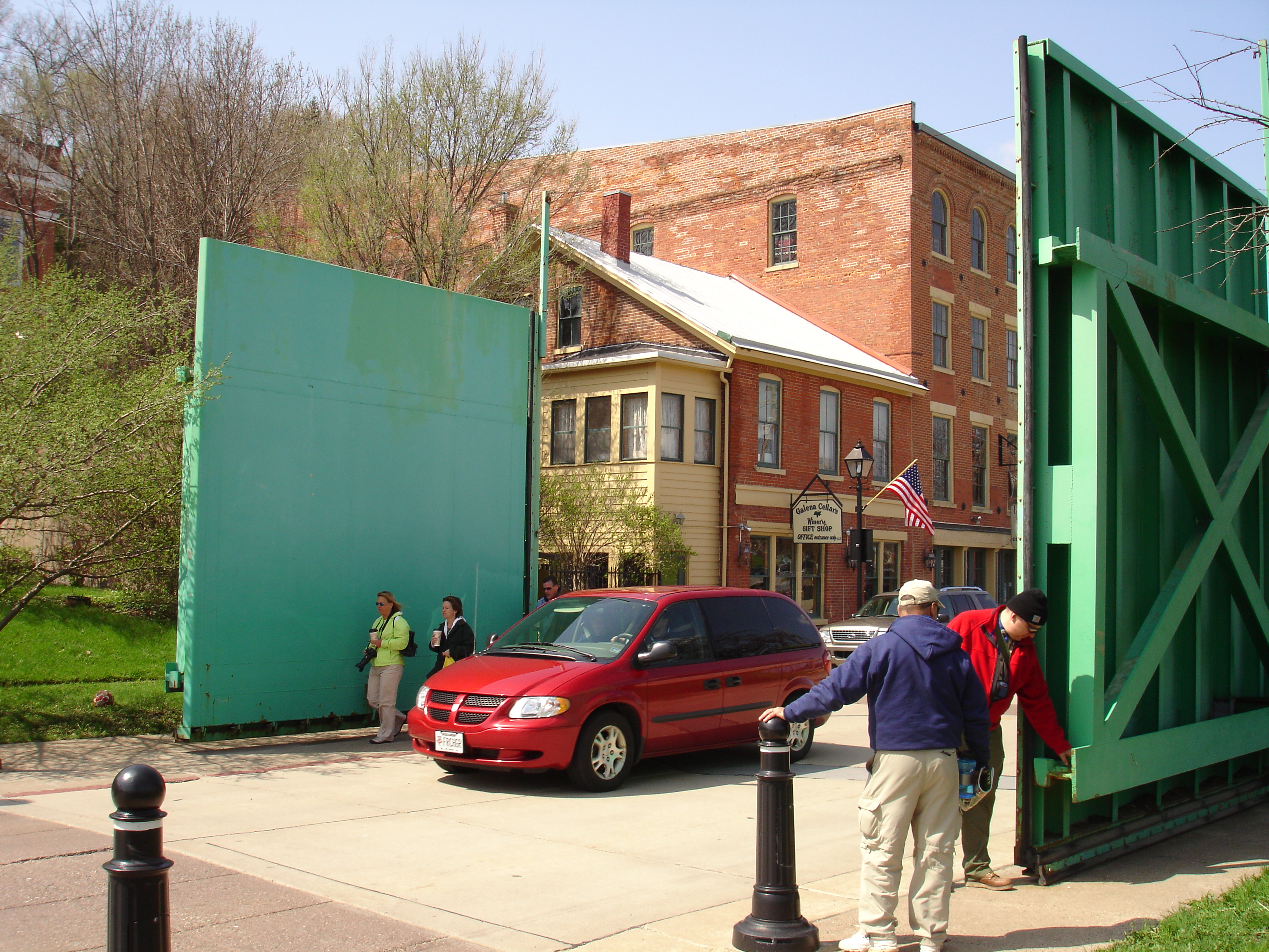
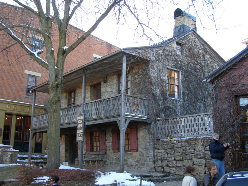
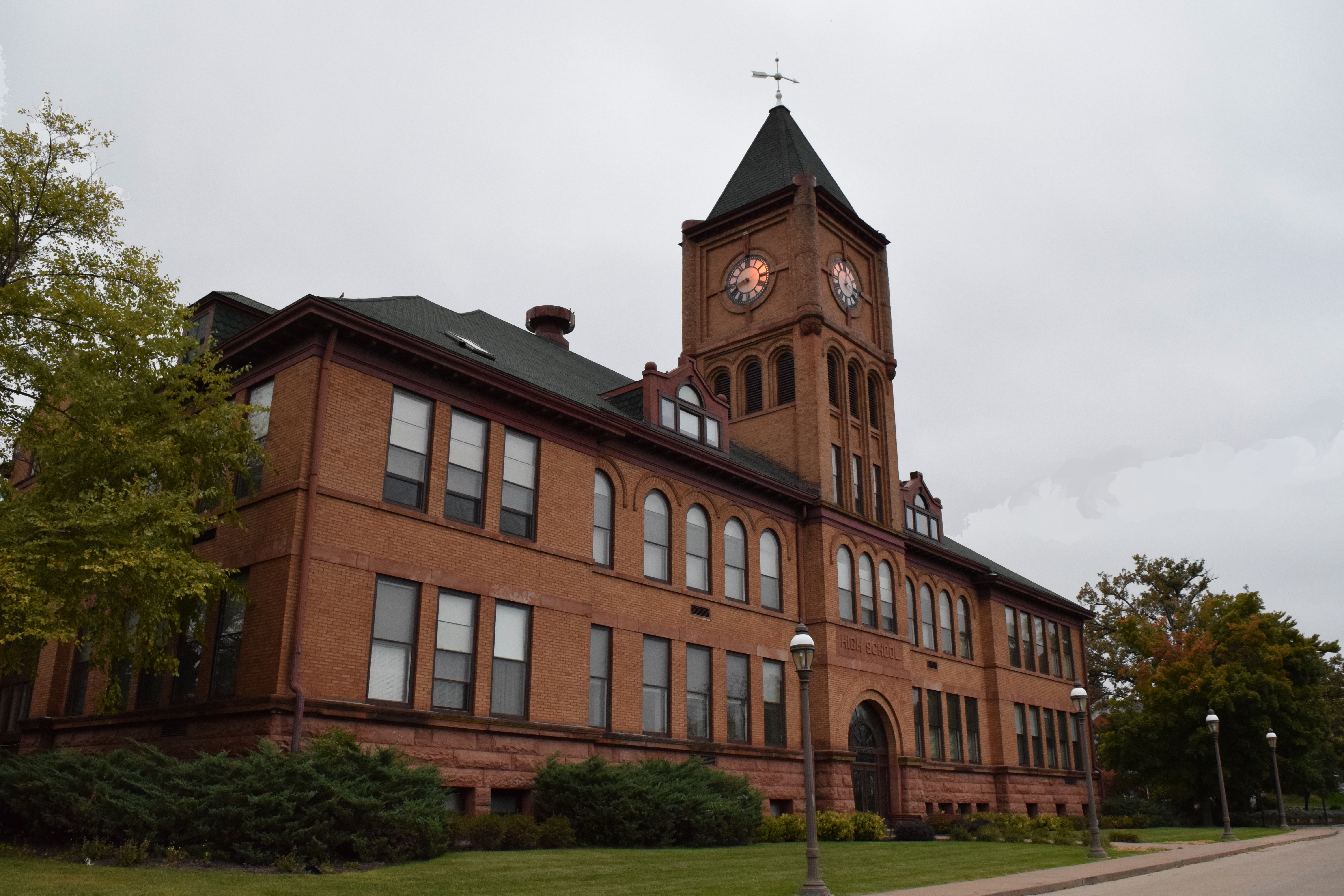
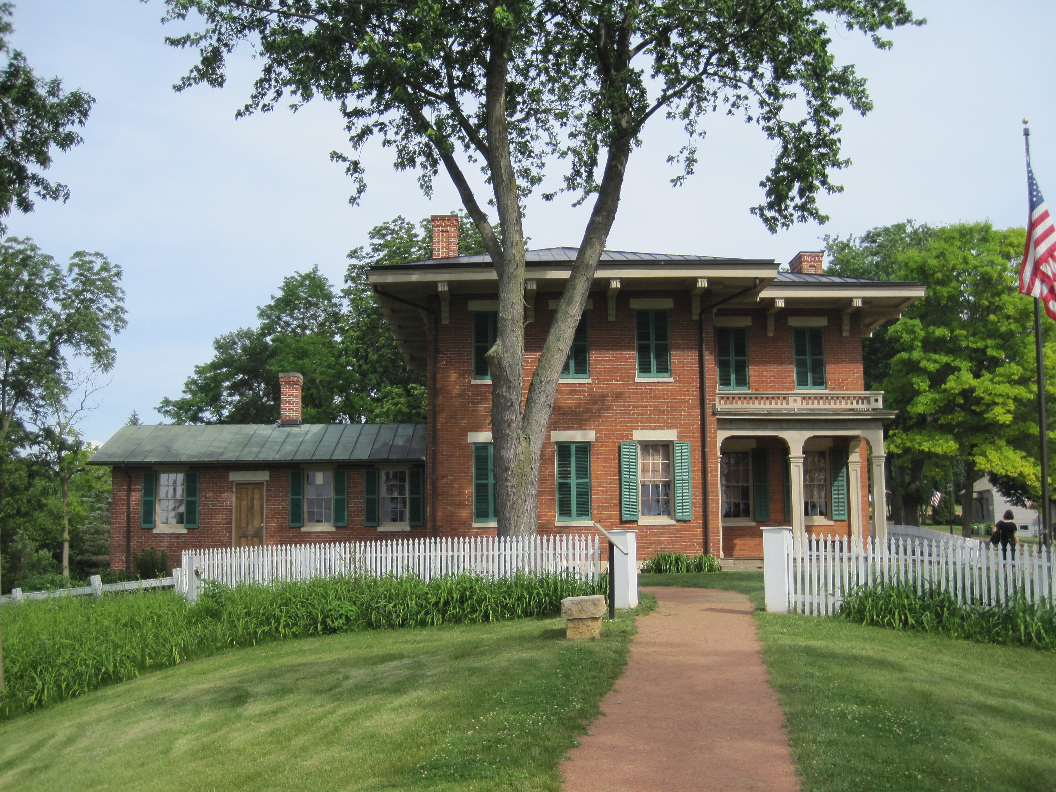
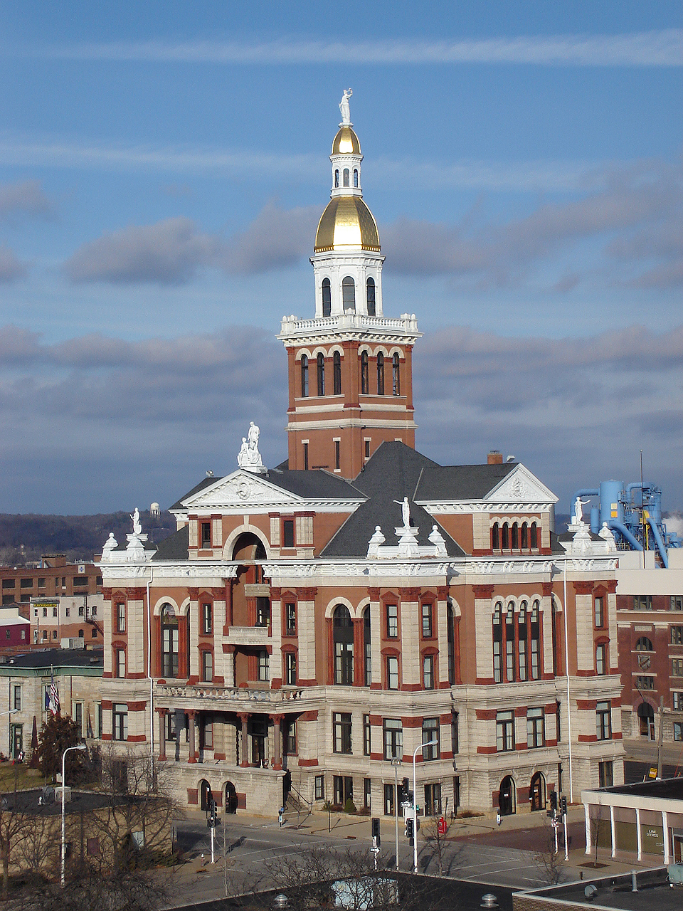
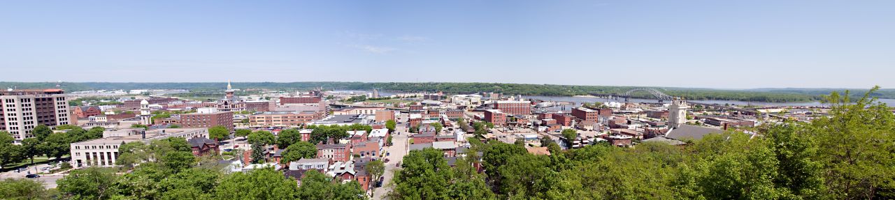
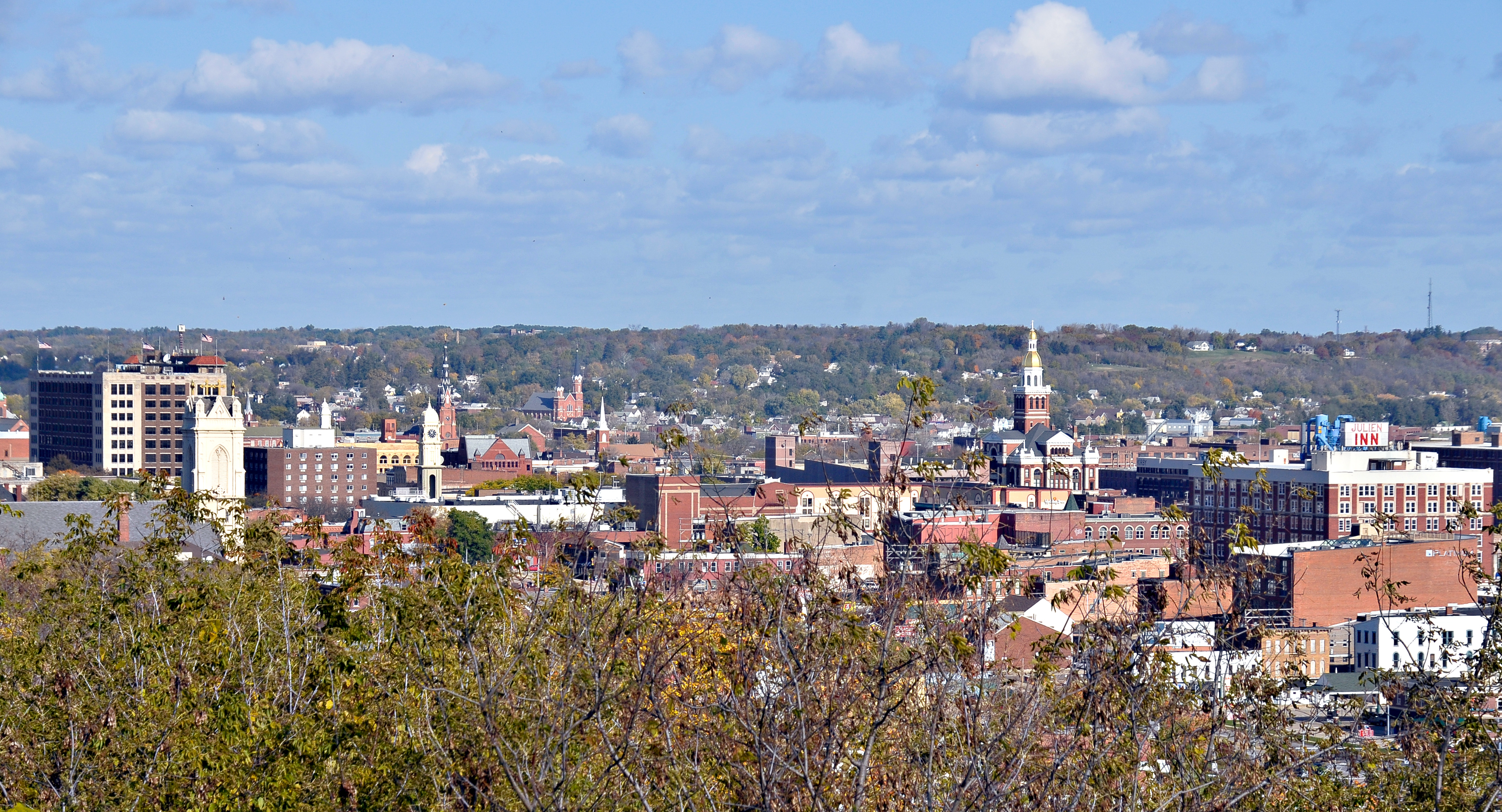