|
Reflections 2016
Series 3
March 12
Mississippi River IX: St Louis
| | St Louis We'll temporarily suspend the narrative of our arrival in St Louis, since we're totally lacking in background. We've seen the below Central Corridor map before, so we can get re-oriented from it:
http://explorestlouis.com/wp-content/uploads/2011/02/VG15_CentralCorridorMap_NoSpot-Callout.pdf
| | | | We'd come from the south at Route 66 State Park (Times Beach) and, taking advantage of still having the car, visited Forest Park, then went down Lindell Boulevard to Newstead (expand view) to see the (newer) Cathedral of St Louis, with its mosaics. SW of the intersection of Jefferson & ML King we saw the Scott Joplin House, the closest we came to downtown. We then swung north to St Charles and then to the Illinois side of the Mississippi. Everything we'll visit now is downtown, in walking distance from the hotel, or via the MetroLink light rail system. We can now dispose of this map, but just note two things not on our next map, the East Riverfront light rail station in Illinois, and the Soulard neighborhood south of downtown. We'll later refer to both. We will now use this St Louis Downtown map extensively, so keep it handy in another window:
http://explorestlouis.com/wp-content/uploads/2011/02/VG15_Downtown-Map_NoSpot.pdf
| | | | I would grumble again that the map is turned sideways, with north on the right, but in this case, it's historically a good idea, since St Louis began at the river, and grew inland. This map shows the importance of the riverfront historically, and why the Gateway Arch was put there. The downtown area of most interest is largely between the bridges you see heading inland to (the trainless) Union Station. For further orientation, the Scott Joplin House is on Delmar Boulevard two blocks west (toward the top) of Jefferson, but still, better reached by car. | | | | Go back to the riverfront and let's lift off several centuries of history. Almost every settlement on rivers in Middle America started life as a riverport, mostly serving steamboats. In the last posting alone, we stopped at Jefferson Landing in Jefferson City, and discussed Independence Landing in Independence and Westport Landing, which served Westport, but which became Kansas City. In St Louis, we have Laclède's Landing. | | | | The simplified story is that St Louis was founded in 1764 when French fur trapper Pierre Laclède came up from New Orleans with his stepson and assistant Auguste Chouteau and 30 men to set up a trading post. But that sounds so cut-and-dry--there was more to it than that, and it involves places we know and have visited. This is the fuller story. His Plan A was to set up a trading post in 1763 on the west bank of the Mississippi near and just north of Ste Genevieve, and he arrived there with his trade goods. But he found that there was not adequate storage for his goods, and Ste Genevieve was too low and prone to flooding. (Remember, it was later moved from its original to its present site because of that.) So Laclède arranged to have his goods stored at another location we know, the Fort de Chartres on the Illinois side of the river. | | | | But then the garrison became British, and in addition, many ethnic French wanted to leave British Illinois to what they still considered to be French Louisiana on the opposite shore (they didn't know yet it would be Spanish Luisiana). So at this point, Laclède decided to establish a community around his trading post as well, and was sure that many French from Illinois would come to settle there. | | | | So in December 1763, he moved further upriver to try his Plan B, which was to establish a trading post plus a community at another spot we know well, the confluence of the Missouri and Mississippi. But we also know how easily it floods there too, and he found the confluence was too marshy to build a town. So he went to what became his Plan C and moved 29 km (18 mi) downriver to where St Louis is today. (This finally explains something I wondered about for a long time, why St Louis is so near that major confluence, yet not right at it.) They reached the site of St Louis in April 1764, cleared the land, and established their riverfront trading post and town, which they named for Louis IX, King of France and saint. The St. Louis downtown riverfront area is named Laclede's Landing in Laclède's honor. | | | | This is a map of St Louis in 1780. It was found in the archives of Seville, Spain, but that should not surprise us, since this was by then Spanish territory. It refers to the town as St Louis des Illinois / St Louis of the Illinois, indicating a cross-river blend of concepts. The flow of the river is shown correctly. While the landing is still there (see our St Louis map), all these streets are now gone, replaced by parkland and the Gateway Arch. We'll see shortly how St Louis eviscerated itself of its historic heritage in favor of the Arch and parkland around it. I've never seen any other city where this was done willingly (and not due to warfare). | | | | We move up a decade for this map of St Louis in the 1790s, published in 1826, from the Library of Congress. While similar, it mistakenly shows the river magically flowing upstream, and it's the only time I've seen the anglicized spelling Lewis used as part of the name of the city. | | | | St Louis served for most of its first century as a prosperous outpost adjoining the western frontier. Its population increased 228% in the 1810s. It doubled between 1835 and 1840, and doubled again by 1845. Within ten years it went from half the size of Pittsburgh to twice its size. | | | | In the beginning, St Louis was largely comprised of French colonists, with family names and street names in French. Later came Americans from the East, English, Irish, and soon after, Germans. By 1850, 43% of all St Louisans were born in either Ireland or the German countries. In 2015/3, we talked about German immigration to Texas to Fredericksburg and New Braunfels, much of which was aided by societies such as the Mainzer Adelsverein, the Mainz Society of Nobles. German settlement in St Louis (and Missouri) was helped by romanticized descriptions ("the American Rhineland!") of the area by the 1833 Gießener Auswanderungsgesellschaft / Giessen Emigration Society (Giessen is an hour north of Frankfurt.) Many from Saxony started arriving as well. While the society's effort was considered a failure, it had great influence on the German character of 19C St Louis and Missouri. | | | | | | These are some German street names in St Louis. There are many others, but these are the most recognizable: Allemania St (anglicized version of French name for Germany); Baden Av; Bamberger Av; Beethoven Av; Bremen Av; Cologne Av; Dresden Av; Germania St; Goethe Av; Hamburg Av; Hildesheim Av; Koeln St (German version of Cologne); Luther Av; Salzburger Av; Schiller Av.
The Anzeiger des Westens / Gazette of the West was a German-American newspaper in St Louis, the first of several. For a time in the 1840s, it had the largest circulation of any newspaper in Missouri.
|
| | | | Back to what is now known as Laclède's Landing. The first steamboat arrived in St Louis in 1817—it's how most immigrants arrived in subsequent years—to the point where 100 boats a day docked at the landing, sometimes three deep and up to a mile long. St Louis was the third busiest US port until the beginning of the Civil War. | | | | This is a north view of the Landing in 1857. We can now reflect on the fact that the Arabia would have docked and sailed from here the previous year, on 30 August 1856 (see poster in 2016/2), on its way to Jefferson City, Kansas City, and its meeting with the snag. We also have a never-mailed postcard (remember how helpful postcards are historically!) of the Landing circa 1895. This also shows the famous 1874 Eads Bridge in the background (see modern SL map). When the railroads arrived starting in 1857, including later over the Eads Bridge, they were also bringing new immigrants, and it was the start of the decline of the steamboats. | | | | It was with this hustle and bustle around the turn of the 20C that the 1904 St Louis World's Fair was a showcase for local pride. But, as we've said, it was to be the swan song of St Louis. Afterward, St Louis suffered many years of decline and neglect. Its population peaked at over 850,000 in 1950, but in 2013 was down to only 318,000. While elegant neighborhoods around Forest Park and beyond continued to thrive, downtown suffered. Finally, it was decided to make a major change downtown, the building of the Jefferson National Expansion Memorial, including parkland and the Gateway Arch, as a memorial to Jefferson and his vision of westward expansion. | | | | The buildings in the affected run-down, decrepit area were not ancient—fire had taken care of that in the past. Most structures were Victorian-era brick warehouses, and most of these were removed in what was considered an act of urban renewal. About the first three blocks of riverfront between the Poplar Street Bridge and Eads Bridge—huge sections of 1st, 2nd, and 3rd Streets, all part of Laclède's Landing, and all original to his street plan--were mostly cleared away (see SL map). The only part of Laclède's Landing that was left is the approximately three blocks by three blocks between Eads Bridge and ML King bridge (see SL map). This remnant, now a small, urban historic district, is now what most people probably picture as the full extent of the Landing, not realizing how much of it has disappeared. There is some nice architecture there, which reflects what was lost. Still, you can't make an omlet without breaking some eggs. | | | | We really have to look at the area right after it was razed in 1939-1940. This is a riverfront view circa 1942 (Photo by Jefferson National Expansion Memorial Archives). This photo has a LOT of history. Start by clicking on the bottom. This is the MacArthur Bridge, which in its day saw both auto and rail traffic (more later). Our SL map doesn't reach that far. The first bridge on the SL map is the Poplar Street Bridge, which wasn't built until 1967, but which definitively defines the southern end of the park area around the Arch, so it would be at the bottom of the razed area. | | | | In the razed area, which is the totality of the original St Louis, large sections of 1st, 2nd, and 3rd Streets, plus cross streets, are still discernable here, but gone today, and grass-covered. The tracks around the area have since been removed. But look what is left! In the no man's land they've left the Old St Louis Cathedral, and a block beyond and to the left, you see the dome of the Old Courthouse, both still impressive sights to see today. | | | | The far end of the razed area ends at the Eads Bridge. The few blocks beyond are what today is the historic district of Laclède's Landing, whose far end will be defined by the ML King Bridge once that is built in 1951. | | | | For now, let's jump ahead to today and see a modern view of the area, again from the south (Photo by Kbh3rd). This is roughly the same view we got (though at night) last November, when the Texas Eagle crossed the MacArthur Bridge. The landing is still there, the venerable Eads bridge is in the distance, with the higher ML King Bridge behind it. | | | | Before we go into other details, we deserve a composite view—actually two. This is a panorama of downtown St Louis (Photo by Buphoff) from the Illinois side (click), right up to the Eads Bridge (and King Bridge). We get our first straight-on view of the Arch, and see how nicely it encompasses the Old Courthouse with what we now see is a green dome. Also note, over the Courthouse's right shoulder, the dark red-brick Wainwright Building, which we'll visit later as well. And, to the left, you can't miss the green spire of the Old Cathedral, which is now a free-standing structure pretty much surrounded by parkland. | | | | Now let's go up into the air for a higher view (click). On the left we now see the Poplar Street Bridge defining the southern border of the area, as well as the red seats in Busch Stadium. On the right, beyond the Eads Bridge is the present Laclède's Landing district with the approach to the King Bridge on its far side. In the center, you see the "woodsy" Old Cathedral better, and the Old Courthouse framed by the arch, with the bright red Wainwright building also showing. Note that the parkland from the Arch extends quite a bit westward, all the way to Union Station—although some buildings remain in that stretch—and confirm that on the SL map. | | | | It would be nice to say that we saw the parkland in the pristine state as in all these pictures, but it wasn't quite so. I'd been warned when I booked the American Queen that because of massive construction around the Arch, our departure from "St Louis" would actually involve our being bused to Alton to depart. So a lot of the greenery in these pictures was actually brown earth being dug up in between chain link fences on either side of a pathway. Everything could still be visited, so it was just a minor inconvenience. And I was sure to make my way down the steps to the riverboat landing, which was open for local excursion boats to ply their trade. I wanted to get the feeling of being on the actual place where the steamboats had been, including the Arabia. | | | | They want to expand the underground visitor center and museum below the Arch, and connect it over to the Old Courthouse. They want a new cobblestone plaza between the Arch and the river. They want to cover over I-44 (see SL map). The work was planned to coincide with the present 50th anniversary of the completion of the Arch (28 October 1965–2015) but (HA!) the renovation is now 14 months behind schedule, so the present plan is to complete it by December 2016. Well, there seems to be an old St Louis tradition here. The centennial of the Louisiana Purchase (1803-1903) was celebrated by the St Louis World's Fair—in 1904. | | | | St Louis Blues In the discussion of WC Handy's Memphis Blues and Beale Street Blues in Memphis in 2015/7, we purposely omitted what is arguably his most famous composition until we've arrived, appropriately, in Saint Louis. That is of course the St Louis Blues, published in 1914. Handy said he'd been inspired by a chance meeting with a woman on the streets of St Louis who was distraught over her husband's absence. Here we have on YouTube the 1925 version with Bessie Smith and Louis Armstrong on cornet, which was inducted in the Grammy Hall of Fame in 1993 (3:13). | | | | The Name "Louis" The name "Louis" came to English from French, where it's pronounced in one syllable as LWI. There are two pronunciations of the name in English, LU.i and LU.is, the only difference being whether the S is included or not. LU.i is as close an imitation as possible of the French pronunciation, though in two syllables, while LU.is, is a more home-grown version. Each pronunciation has an alternate spelling. LU.i can be spelled Louis or Louie; LU.is can be spelled Louis or Lewis. Therefore, it's only the spelling "Louis" that's tricky when it comes to which pronunciation is being referred to.
| | | | In referring to the city of St Louis, the pronunciation is normally LU.is, with the S. But in the World's Fair song "Meet me in St Louis, Louis", both the city and proper name are pronounced LU.i. This is also true in the St Louis (LU.i) Blues. It would appear that in song, the name of the city can more easily become S-less. | | | | Day 11 (Continued) Visiting Saint Louis 1 We now come back to our narrative, having arrived early from KC on the Missouri River Runner just before 2PM at Gateway Station (Photo by David Wilson), which opened in 2008 and operates 24 hours a day. It's Missouri's largest rail transportation station. On our map, the rail route runs along the tangle of highways from the top (west) to the station at 16th Street. The station is nice enough, and serves as a complete transportation center along with Greyhound buses and a MetroLink station, as the map shows--this is Amtrak's access bridge (Photo by Chris Yunker) to and from its platforms. But this facility is just a few blocks away from the now trainless Union Station between 18th and 20th, which is used for other purposes. Amtrak did operate out of Union Station from its inception in 1971 until the station closed in 1978, but no longer does. Kansas City uses its station for other purposes, too, but still allows for train service. It just seems like such as waste. | | | | For the moment, we'll just pass by the attached MetroLink light rail station (Photo by Larry Pieniazek), since we'll ride through here later. For now, we just want to take the downtown shuttle (orange route on map) to the hotel to drop off our bag. The shuttle is meant largely for visitors, costs $1 for seniors (pay driver), and is hop-on, hop-off, if you want to use the same ticket all day—but we have our own plans for later. | | | | Follow the orange route down to Broadway, and you'll find the rather awkwardly named Hilton St Louis at the Ballpark. As you may recall in Memphis, the American Queen includes in its rates the night before in a local hotel. Here, this is the hotel it chose, and I elected to pay for one extra earlier arrival night to have enough time in St Louis. | | | | You know how important I find location in choosing a hotel, and this Hilton can't be better. However, when I saw the name I bristled. I'm no fan of organized sports, but the Hilton decided to include in its name the fact that its whole south side, plus the south side of the rooftop bar, has a view over one low-rise block right into Busch Stadium. I, on the other hand, with different priorities, would have called it the Hilton at the Arch, Hilton on the Gateway Mall, or something similar to point out how perfectly it's situated adjacent to these landmarks. | | | | I mentioned at check-in that I did not wish to stare into a stadium, or hear the corresponding noise, but told them what I did want, and it couldn't have worked out better. While the 360 Rooftop Bar, with views in all directions, is on the 26th floor, my room was on the 22nd and looked down at a perfect angle onto the Old Courthouse, and at a somewhat steeper angle at the Gateway Arch. It was this view below, though from a higher floor. I was very satisfied:
http://media-cdn.tripadvisor.com/media/photo-s/06/8d/30/d2/hilton-st-louis-at-the.jpg
| | | | It was now time to start looking around, and, having seen the more-distant sights by car earlier, everything left was right here, walkable or via the MetroLink! We started with three buildings of interest, working our way down toward the river. | | | | Our first stop is the Wainwright Building, and architectural gem and a National Historic Landmark and city landmark. While the Michelin Guide (USA East) directed one's attention to it on its map, our SL map unfortunately does not. It's located diagonally across the plaza from the hotel, on the north (right) side of Chestnut between 7th and 8th. It even has a MetroLink station on its far side. | | | | Many of us are aware of the architect Louis Sullivan as being called the "father of skyscrapers". He worked out of Chicago after settling there after the Great Fire of 1871, because of the building boom that followed. He was a mentor of Frank Lloyd Wright, and the two of them, plus HH Richardson ("Richardson Romanesque"—see the Old Red Museum in Dallas in 2015/4, also Union Station below) have been called "the recognized trinity of American architecture." | | | | Sullivan's contribution seems so obvious today-ah, hindsight--but revolutionary in the late 19C. Tall buildings at the time had to be supported by their walls. The taller the building, the thicker the walls, particularly at the bottom, which restricted the building's height. But this was also the period when steel girders came into their own, and by assembling a steel framework, architects could suspend a building from it, the walls, floors, ceilings, and windows. They could then create tall, slender buildings on a strong and relatively lightweight steel skeleton, which carried all the weight. This also allowed for larger windows and more daylight reaching the interior. Even interior walls became thinner, allowing for more floor space. This is the basis for the modern skyscraper, and this is Sullivan's great contribution. | | | | Sullivan also decorated his outer surfaces with lush Art Nouveau decorations of vines and ivy, or more geometric designs, and these were often made in terra cotta, which is very lightweight and was also coming to its own at the time. Alternately, the decorations could be made of cast iron, as we'll see in Laclède's Landing shortly. | | | | So as we cross the Gateway Mall, we come face-to-face with the Wainwright Building (Photo by BirgitteSB), a rare example of Sullivan's work in St Louis (Chicago has the bulk of his work). It's a magnificent example of Victorian red brick (click), so typical of the era. Sullivan and his partner at the time, Dankmar Adler, built it in 1891. Its Italianate Palazzo style is indicated by that marvelous cornice at the top of its ten stories. It's among the first skyscrapers in the world and a prototype of the modern office building.
| | | | Sullivan liked to use the three parts of the classical column (base, shaft, capital) as a basis for his building design (base, shaft-attic), which is easily discernable here. Since a column is all about height, he felt those elements would emphasize the height of his buildings. The ● base of the Wainwright is undecorated. The central ● shaft of the building shows extensive floral terra-cotta design in the spaces between windows known as spandrels, visible in the previous picture and in this detail of the top (Photo by J Crocker). But it's up at that ● attic level that the Wainwright really stands out. The previous picture, as well as this further detail (Photo by Carptrash), show the intricate, wide floral frieze and bulls-eye windows under that deep cornice. The floral motif expresses the formalized, yet naturalistic, celery-leaf foliage typical of Sullivan. The bulls-eye windows light the top-story floor, which originally was utilitarian, containing water tanks and elevator machinery. | | | | Despite its importance, the Wainwright Building was scheduled for demolition during the 20C, and had to be rescued by the National Trust for Historic Preservation (of which I'm proud to be a member). Later the State of Missouri acquired it and it is officially today the Wainwright State Office Building. | | | | On our map, follow our route across the plaza to the Old Courthouse, which we've seen pictured earlier, and which takes up an entire city block. This view of the Old Courthouse (Photo by Jeremy Noble) from the top of the Gateway Arch shows just where we are. The Hilton is the two white towers beyond the shiny black tower on the left. The red-brick Wainwright is half-visible up the Gateway Mall, on the right. And the Old Courthouse makes a splendid centerpiece, as it has done since the 19C. | | | | The original building was completed as a combined state and federal courthouse in 1828 in Federal style, shortly after Missouri became a state in 1821. But then the St Louis population tripled in ten years and the courthouse was rebuilt over a number of years in Greek Revival style, at first with a three-story cupola dome. But in 1861, at the start of the Civil War, the cupola was replaced with an Italian Renaissance cast iron dome, completed in 1864, modeled on St Peter's Basilica in Vatican City. (You might recall our discussing in 2013/4 that the US Capitol dome was built at the same time during the War, and was also modeled on St Peter's.) It was even formidable in its day, since it was Missouri's tallest habitable building for the three decades after its completion until Union Station was built further inland in 1896. | | | | As we visit the Courthouse, we find that, where there had been up to 12 courtrooms, there are museum galleries and offices, plus two courtrooms in period presentation: the east wing has Circuit Court #13 restored to its 1910 appearance, while the west wing has Circuit Court #4 as it looked in the 1850s. | | | | But don't forget that dome. There are wide, old—and vertiginous—staircases leading up to the upper floors so you can visit the interior of the Rotunda (Photo by Bill Whittaker). Click so you can see the railings along the upper walkways. But I suggest you hold on to a railing with both hands when you look up to see the interior of the dome, looking straight up (Photo by Kbh3rd). Good luck on keeping your balance as you look up, considering the formidable drop straight down.
| | | | This last Courthouse picture is at an interesting angle (Photo by QuartierLatin1968). Click to see that it shows the east portico (more later), but then it also shows both towers of the Hilton St Louis at the Ballpark. You see the tower with the name, but I was in the closer tower. You can see the glass-enclosed 360 Rooftop Bar where I had dinner one night, having an interesting chat with a guy at the bar. (The part that faces the ballpark is an open terrace). Again, the bar is on the 26th floor, so count down on the left façade of the tower four floors to the 22nd, and that's where my room was. Aside from looking right down on the Courthouse, and at an angle to the Arch, I had beautiful sunrise views, too (I get up earlier when traveling). | | | | We now have to look at the other side of the coin, so let's get back to that east portico of the Courthouse, facing the river. Slave auctions were held at the Probate Courts near the east door. These were for slaves whose owners had either died without a will or who went bankrupt. The last slave auction at the Old Courthouse took place in 1861, just as the Civil War was starting. | | | | And we have to keep on that same subject to discuss a momentous event. The person in question is famous. But it's a decision made involving him that is infamous in American history. We're taking here about Dred Scott and the infamous Dred Scott Decision of the US Supreme Court. | | | | Even beyond the immorality and opprobrium of slavery, it is particularly "peculiar" that the so-called "peculiar institution" of slavery existed in the US just in the pattern it did at the time of the Civil War. This is the status in 1789 ,which doesn't yet show a pattern. Eventually, northern states that had allowed slavery had abolished it (New York State did so between 1817 and 1827), leaving the southern states, whose agricultural economies relied on free labor, standing alone, as this map at the start of the Civil War in 1861 shows (Both maps by Golbez & Kenmayer). The pattern is now obvious, but the peculiarity is the role played by the rivers we've been discussing, as it turns out by chance that the Ohio and Upper Mississippi Rivers were the de facto borders between North and South. Note in particular for our next discussions how the Ohio separates Kentucky and Ohio, and how the Upper Mississippi separates Missouri and Illinois. These rivers became de facto escape routes for runaway slaves heading north and into Canada. | | | | The most famous, graphic illustration of this is in Harriet Beecher Stowe's 1852 two-volume anti-slavery novel Uncle Tom's Cabin. In Kentucky, Eliza's son Harry, as well as Uncle Tom, are in danger, and here Eliza warns Uncle Tom, then flees across the ice floes on the Ohio River from Kentucky to Ohio:
https://upload.wikimedia.org/wikipedia/commons/7/7f/Uncle_Tom's_Cabin%2C_Translation_by_Annenskaya_p77.png
She succeeds, and she and Harry meet up in Ohio with her husband George Harris, who had escaped earlier.
| | | | | | [The first and third illustrations are from the first edition of the novel (1852 Boston). The second is from the Russian translation (1908 St Petersburg) titled Хижина дяди Тома ("Khizhina dyadyi Toma", or "The Cabin of Uncle Tom"). Remember, this is world literature. In that vein, you may recall that, in Rogers & Hammerstein's The King and I, the locals present a Thai version of The Small House of Uncle Thomas.] |
| | | | The Dred Scott story is similar, dealing with two sides of a river, except the river involved is the Upper Mississippi. While what happened is taught in school history classes, the full story is very revealing of the times and the legalities of the day. | | | | Dred Scott was born in Virginia. I've always wondered about his name, and it turns out that the origin is unclear. That could just have been the name given him, or it could have been a shortened form of Etheldred. | | | | | | The oddity there is that Etheldred is a woman's name, an early form of Audra or Audrey. In Anglo-Saxon it was Æðelþryð (æ as in cat; ð as in this; þ as in thorn, the name of the letter); æðel was "noble" (German: edel), þryð was "strength". |
| | | | Scott moved with his owner, Peter Blow, to Alabama, then St Louis. A second owner, Army surgeon John Emerson, traveled frequently from St Louis to new postings, notably in 1836 to Fort Armstrong in Rock Island, Illinois. In 1837, Emerson took Scott to Fort Snelling (which we've discussed in the past, and will again when we reach Minnesota), located in what was then the free territory of Wisconsin, later transferred to Minnesota. There, Scott met and married Harriet Robinson, an enslaved woman. The marriage was formalized in a civil ceremony presided over by a justice of the peace. Since slave marriages had no legal sanction, supporters of Scott would later point to this ceremony as evidence that Scott was being treated as a free man. Nevertheless, Harriet was transferred to Emerson, who treated the Scotts as an enslaved couple. These are the restored quarters (Photo by McGhiever) of Dred and Harriet Scott at Fort Snelling (1836–1840). | | | | Emerson married Eliza Sanford and returned to Missouri, having the Scotts rejoin him in 1840. On the way, Harriet gave birth to a daughter, Eliza, on a steamboat between the free areas of Illinois and Iowa; they later had a second daughter, Lizzie. But then Emerson died, and his widow Irene inherited his estate, including the Scotts. In 1846, Scott attempted to purchase his and his family's freedom, offering $300, about $8,000 in current value. However, Irene Sanford Emerson refused, prompting Scott to resort to legal recourse. | | | | In 1846 Scott filed legal suit in St Louis Circuit Court (right here, where we are standing, in the Old Courthouse's west wing). Scott stood on solid legal ground, as Missouri precedent dating back to 1824 had held that slaves freed through prolonged residence in free states would remain free when taken back to Missouri. The doctrine was known as "Once free, always free." The Scott v. Emerson case was tried in 1847 in the Old Courthouse. It required a retrial, finally held in January 1850, and the jury found for Scott's freedom. | | | | But then Irene Sanford Emerson appealed. In 1852, the Missouri Supreme Court struck down the lower court ruling, arguing that growing antislavery sentiment in the free states made it no longer necessary for Missouri to defer to the laws of free states. In doing so, the court overturned 28 years of Missouri precedent. But then in 1853, Scott sued again, this time rising above the state level and suing under federal law. Irene Sanford Emerson had moved to Massachusetts, and Scott had been transferred to her brother, John Sanford, a citizen of New York. Since Scott would be a citizen of Missouri if he were free, with two states involved, the Federal courts had jurisdiction. | | | | | | In retrospect, it has to seem more and more obvious that there were outside forces involved here. Where would an enslaved person have the money for all this legal action? Local outsiders funded the suits, and a lawyer worked pro bono. But it was then no accident that Federal courts got involved, since abolitionists were looking to make a test case on the slavery issue. And when they found that John Sanford was a New Yorker, Dred Scott in Missouri was to become that test case. |
| | | | But Scott lost again in Federal District court, and they appealed to the US Supreme Court in the infamous case known, no longer under the Emerson name, as Scott v. Sandford, whereby a clerical error added a D to Sanford. The stage was now set for the Dred Scott Decision, and Scott lost. | | | | The court of that era was presided over by Chief Justice Robert Taney, and Taney's biggest legacy is this infamous decision, given on 6 March 1857. Six justices agreed with the ruling, one concurred, but for different reasons, and two dissented. Presumably Taney and the majority thought that this would finally settle the slavery question, although it's hard today to comprehend the reasoning. It looks more today that the Court really shot itself in the foot. The decision not only went against Scott, it made legal matters much worse than what had been the status quo. In essence, the ruling went beyond Dred Scott, saying that any person descended from Africans, whether slave or free, is not a citizen of the United States, according to the Constitution, and had no claim to freedom or citizenship. As non-citizens, they didn't even have any standing to bring suit in Federal court. Taney actually quoted the Fifth Amendment of the US Constitution, which prohibits taking property from its owner "without due process", and, since Scott and other enslaved persons were private property, Congress did not have the power to regulate slavery in the territories and could not revoke a slave owner's rights based on where he lived. It would seem that, not only could slave owners take slaves to free areas, Congress couldn't even limit slavery in free territories, in case a slave owner wanted to move there. What a mess! | | | | | | We rarely if ever get into the law here, domestic or international, but we did once before, in Canada, and it's worth referring back to here. One conclusion of several reached by the majority of the Taney court was that the Court didn't have jurisdiction, since Scott was the descendent of an imported African slave, could not be a citizen of any state, and could not bring suit. Scott argued that he had been emancipated, and had the status of citizen. Taney spent fifteen pages of the majority decision arguing that, at the time the Constitution was ratified, federal law would not have recognized Scott as a citizen. Taney was looking to the past to solve a problem of the present.
We can now refer back to the Persons Case in Canada ("Women are Persons"), when the women known as the Famous Five sued in the Canadian Supreme Court, contending that they were indeed "qualified persons" as defined in the Constitution Act of 1867 to be elected to office, and, by extension, to vote. But the (Canadian) Supreme Court didn't want to be activist, and waffled, giving a traditionalist interpretation. As discussed in 2013/4, they looked back to the past, saying that, since women couldn't sit in Parliament at the time, the constitutional drafters in 1867 would have denied the current action, even though the role of women had changed by the 1920s.
At the time though, the Supreme Court of Canada was not really supreme, and the question was then further referred to the Judicial Committee of the Privy Council in London. It reversed the decision, in favor of the Famous Five, but then did more. Just the opposite of what the Taney Court had done when it yielded an infamous decision then did additional damage, the Privy Council gave a positive decision, then did additional good, and thereby gave a gift to the Canadian people. As we said in the earlier posting: The reasoning involved an entirely new approach to constitutional interpretation that since has become fundamental to Canadian law. The reasoning was that the [Constitution] was not something etched in stone, but instead [it] planted in Canada a living tree, capable of growth. This living tree was the Canadian Constitution that should be subject to development. The interpretation of the Constitution should not be "narrow and technical", but "large and liberal". This decision then developed into the living tree doctrine of Canadian law, requiring broad and progressive interpretation, not necessarily limited to what the framers might have thought, which, like women's rights, might be out of date, but which is adapted to changing times. Limiting a constitutional interpretation to just the framer's intent without reflecting societal changes roots the Constitution in the past and would no longer be reflective of contemporary society. It's instructive to compare these two legal interpretations
|
| | | | This incredible decision of the Taney Court was so controversial, it inflamed North-South passions even more, and contributed to, rather than reducing, tensions leading to the Civil War. The decision was a lead-in to the Emancipation Proclamation and was only overturned when three Amendments to the Constitution were passed later on. Scholars uniformly denounce the decision as being the worst the Supreme Court ever made. | | | | Once the Emancipation Proclamation was issued in 1863, since it was really only a weak, wartime, presidential declaration, it had to be backed by more solid legal means. The Thirteenth Amendment to the US Constitution was passed by both houses of Congress, and then by the required number of states, to be adopted on 18 December 1865. Its Section 1 stated definitively that Neither slavery nor involuntary servitude, except as a punishment for a crime . . . shall exist within the United States . . . . | | | | But legal verbiage was needed to directly undo the massive damage the Taney Court had done in the Dred Scott Decision where it stated that African-Americans cannot be citizens. That was accomplished by the Fourteenth Amendment, adopted on 9 July 1868. The first clause of its Section 1 is referred to as the Citizenship Clause, which reads All persons born or naturalized in the United States, and subject to the jurisdiction thereof, are citizens of the United States and of the State wherein they reside. | | | | The remaining clauses of Section 1 contain more legal powerhouses. It reads in it entirety that No State shall make or enforce any law which shall abridge the privileges or immunities of citizens of the United States; nor shall any State deprive any person of life, liberty, or property, without due process of law; nor deny to any person within its jurisdiction the equal protection of the laws. While all the remaining clauses are important, we can cite here two that are referred to again and again, the Due Process Clause and the Equal Protection Clause. These make this first section of the Fourteenth Amendment one of the most litigated parts of the Constitution, and form the basis for landmark decisions such as the 1973 Roe v. Wade regarding abortion, the 2000 Bush v. Gore regarding the 2000 presidential election, and the 2015 Obergefell v. Hodges regarding same-sex marriage. | | | | | | The four other sections are of far lesser importance, although reading the beginning of Section 2 is an interesting exercise in history: Representatives shall be apportioned among the several States according to their respective numbers, counting the whole number of persons in each State, excluding Indians not taxed. The oddity is the phrase "the whole number of persons". This reflects the Three-Fifths Compromise made at the Constitutional Convention of 1787, when slaveholder states realized they'd be underrepresented in Congress if slaves weren't counted, but were loath to count them fully. This phrase now certifies that a black person was no longer counted as 3/5 of a person, but was to be a "whole person". |
| | | | Finally, there was the matter of voting, which was resolved by the Fifteenth Amendment, adopted on 3 February 1870. Its Section 1 states that The right of citizens of the United States to vote shall not be denied or abridged by the United States or by any State on account of race, color, or previous condition of servitude. The quaint phraseology of the last four words is a gentle euphemism for having been enslaved. | | | | But the Emancipation Proclamation came out in 1863 and these Amendments were adopted in 1865, 1868, and 1870, whereas Scott was involved in his legal action between 1846 and 1857, so he could see no immediate benefit from them. Fortunately, the story has a positive, though bittersweet ending. We have to go back to Scott's original owner, Peter Blow, who first brought him to St Louis. Peter Blow's three adult children had turned against slavery, and in fact, they were among those who'd been financing Scott's legal matters. Following the Taney Court's ruling on 6 March 1857, it was arranged to transfer the Scotts' ownership papers to Taylor Blow, representing the adult Blow children, who then manumitted (freed) the Scotts on 26 May 1857, in the Old Courthouse in St Louis and before the very same judge who had heard the first case. | | | | Dred Scott then worked as a porter in a St Louis hotel, but unfortunately died of tuberculosis at age 59 on 17 September 1858, so he enjoyed his freedom for about 16 months. But Harriet and their daughters survived him, and Harriet worked as a laundress for many years. She's listed in the 1860 census as living in her own home, and in the 1870 census as a live-in domestic. She died at 61 in 1876. | | | | They are both buried to the northwest of downtown St Louis and not far from it, Dred in Calvary Cemetery and Harriet in Greenwood Cemetery. This is Dred Scott's grave (Photo by Rklawton). Below his dates is the inscription "Freed from slavery by his friend Taylor Blow". I have not visited the grave, but I understand that a local tradition that has developed over the decades is for a visitor to leave a penny on top of the headstone—with the face of Abraham Lincoln showing, of course. While in the picture I cannot read the commemorative marker in the ground, I understand that it reads "In Memory of a Simple Man who Wanted to be Free." | | | | So what is there for us to see on our visit to the Old Courthouse? In the west wing, one of the remaining courtrooms is the replacement, after the remodeling of 1855-1858, for the one where the Dred Scott case was heard. Then, leaving via the east wing, with its slave auction history, we find that, at the foot of the broad staircase (see earlier courthouse picture, and SL map) the one-block stretch of 4th Street adjoining the Courthouse is now called Dred Scott Way.
http://www.thedredscottfoundation.org/dshf/images/stories/Dred%20Scott%20Website%20HP2.jpg
http://bloximages.newyork1.vip.townnews.com/stltoday.com/content/tncms/assets/v3/editorial/5/e6/5e65ccde-c469-576a-9d88-78d80403da51/537fca973a097.preview-620.jpg
| | | | But by far the most inspirational sight is the statue. The first picture above shows the statue of Dred & Harriet Scott that was erected in 2012 to the left of the staircase near the south lawn of the Courthouse by the Dred Scott Heritage Foundation and the National Parks Service. You see (click) how they're depicted standing united, with heads held high. It's a beautiful statue. (You can also see in the left background the Hilton rooftop bar, and not quite my room below.) | | | | But the best is where, as in the second picture, you walk behind the statue. You see how nicely it's framed by the Arch, then realize that's only superficial. Their eyes are actually directed a few blocks away, through the Arch and across the Mississippi to Illinois and freedom on the other side. And so we come full circle to have seen Eliza and Harry fleeing to Ohio on the ice floes on the Ohio River and the Scotts depending on their residence in Illinois and Wisconsin (Minnesota) to help them gain their freedom. | | | | In 1997, Dred & Harriet Scott were admitted to the St Louis Walk of Fame. This is something else I'd been unaware of, and so did not visit. I find it's located on Delmar Boulevard in University City, right adjacent to Washington University in St Louis at the northwest corner of Forest Park, both of which we've discussed in the past. Honored are notables from the St Louis area, and those who spent their creative years there. There are now about 137 brass stars for inductees. I will mention a select few, reluctantly leaving out even a number whose names I do recognize.
18C-19C: Pierre Laclède, Auguste Chouteau, William Clark, US Grant, Scott Joplin, Dred & Harriet Scott;
20C: Maya Angelou, Josephine Baker, Yogi Berra, Miles Davis (from Alton), Phyllis Diller, James Eads (Eads Bridge—more later), TS Eliot, Redd Foxx, Betty Grable, William Holden, Charles Lindbergh (more later), Vincent Price, Joseph Pulitzer, Shelley Winters; The Rockettes (founded in 1925 in St Louis as the Missouri Rockettes; did a guest performance the opening night of Radio City Music Hall in New York and were asked to stay permanently);
I seem to have a thing for cartoonists. These four have stars in St Louis:
https://upload.wikimedia.org/wikipedia/en/d/d6/Hirschfeld's_one-line_drawing_of_Liza_Minnelli.jpg
Al(bert) Hirschfeld became the iconic caricaturist of the Broadway theater. He was so iconic, that in 2003 the Martin Beck Theater on 45th Street was renamed the Al Hirschfeld Theater. Here he's drawn Liza Minnelli with just one line. He always included his daughter's name, Nina, in his drawings, sometimes multiple times, and I remember regularly looking for the "Ninas" in his pictures in the Sunday New York Times. Have you found Nina here? (Look at the left side of her hair.)
https://upload.wikimedia.org/wikipedia/en/1/16/Chicyoungblondie102551.jpg
Chic Young is best known for Blondie (and Dagwood).
The other two are Bill Mauldin and Mike Peters. They are both discussed, among others, in 2012/5, with links to their work. Mike and his wife came to New York with my St Louis friends Bruce and Pat (see below) and we went out to dinner. I was bold enough to ask him for a caricature of me, which he zipped off on the back of a sheet of paper with a wine list on the other side.
| | | | Back to our narrative. As the SL map shows, it's just steps from the Old Courthouse to the Old Cathedral, officially the Basilica of St Louis, King of France and formerly the Cathedral of St Louis. It's "old" because of the large, newer cathedral we already visited near Forest Park, the 1914 one with all the mosaics, which is called the Cathedral Basilica of St Louis, but also St Louis Cathedral. To avoid the confusing terminology, stick to "new" and "old". | | | | It was the first cathedral west of the Mississippi. The current structure (Photo by Tom Bastin) was built 1831-1834 near the historic riverfront. For anyone with a feeling for history, it's odd to see it surrounded by parkland—plus some modern buildings nearby--since it was originally in the urban block grid that was destroyed in 1940, but was one of the few structures considered worth saving. Now, of course, it's right near the Arch. A child of its period, the church is in Neoclassical style, more precisely, Greek Revival (Photo by JesseG).
https://maxyardleyarchokc.files.wordpress.com/2010/03/1971.jpg
| | | | I liked the interior even better. While Michelin is an outstanding guide in any case, one additional fun thing is noting the French point of view it sometimes tends to give. About the Old Cathedral it says: "The simple Neoclassical elegance of the mauve and blue interior strongly reflects the church's French roots." And it's so totally true—those colors truly define the interior. English even uses the French word mauve to describe this grayish violet, and so it's pronounced in the French way, to rhyme with "cove". And the church attracts weddings galore. When I stopped by on both Saturday and Sunday, people were putting flowers on the pews preparing for festivities later in the day. | | | | You will have noticed that the exterior of the church has two inscriptions, as seen twice above and again in this picture with the Arch (Photo by Baylor98). A Latin inscription on a Catholic church is no surprise, but the upper one is in Hebrew, which is. It apparently was an effort to illustrate both of what Christians call the Old and New Testaments, but even while I was there, I found out that they'd misspelled the Hebrew. This of course, intrigued me, and, though I know no Hebrew whatsoever, that's no reason not to check it out. | | | | What they wanted was "Yahweh", a variation of "Jehovah". The word is traditionally inscribed without vowels as YHWH So far, so good. As you can see, there's a duplicate, so the four letters are really only three different ones. Also, Hebrew is spelled right to left, so expect that reverse sequence. Here's what I discovered. | | | | | | Y corresponds to the letter yod, a Y-sound: י
H corresponds to the letter he/heh, an H-sound: ה
W corresponds to the letter waw/vav, a W- or V-sound: ו
The correct spelling of YHWH, in reverse order, is: יהוה
But there's a fly in the ointment. Another letter looks a lot like he/heh:
It's the KH-sound, which is represented by the letter khet/het: ח
Whoops. Here are he/heh and khet/het side-by-side: חה
He/het, the correct one here, has an opening on the upper left.
Khet/het, the wrong one here, has three fully connected bars.
The cathedral used the wrong letter, and so the inscription reads: יחוח
This is, when reversed, not YHWH, but YKhWKh. It's nonsense, chiseled in stone.
It's like confusing Q and O in the Latin alphabet. What's the difference? Just a little tail.
To quote Santa: HQ, HQ, HQ!
|
| | | | Someone who commissions a text to be chiseled in stone in the Hebrew alphabet should be sure he knows what he's doing, and sometimes when people overreach, they stumble, as seems to have happened here. It reminds me of a short illustrated poem by humorist and illustrator Wilhelm Busch, with its put-down of overachievers who might be too full of themselves. It's called Hernach, Der fliegende Frosch ("Afterwards, The Flying Frog"). I've seen these signed illustrations before along with the poem, with an apparent date of 1894:
http://www.wilhelm-busch-seiten.de/werke/frosch.html
| | | | I never rhyme a translation of mine (but never say "never"!), since it usually does more damage than good, but I did manage here to not only follow Busch's 8-8-8-4 syllable pattern (iambic tetrameter, last line iambic dimeter—see 2008/17), but also his AA-BB rhyme scheme: | | | | | | When someone who, with greatest glee,
Has barely made it up a tree,
Begins to think that he's a bird—
Well, that's absurd.
|
| | | | The original last line So irrt sich der, translates best as the über-cool, highly dismissive "Well, he's wrong." I'd have loved to have used that, but it doesn't rhyme! That's the trouble with forcing rhyme onto translations—it forces you to underplay good material. Anyway, would YOU now be ready to commission a stonecutter to write in Hebrew? | | | | Walking down to the riverbank from the Old Cathedral, with wedding preparations being made, I clearly remember hearing the church bells strike 4 PM, a very pleasant touch. | | | | It was now time to move on. I'd heard that the merchants of Laclède's Landing--or at least the remnant that was left in the north, since the whole park area had once constituted the bulk of it—provided a free shuttle from the Old Cathedral area. With some difficulty, I did find the shuttle, and discovered a hidden side to St Louis, a charming backwater, harking back to all that was lost. | | | | Take a look at the SL map. You can see that it was the Eads Bridge in the way that saved this end of downtown from destruction (the ML King Bridge came later, defining the far side of the district). You see a bit of 1st and 2nd Streets, with 3rd seeming to be subsumed. Lucas Avenue is closer to the Eads, then comes Morgan Street. For the most part, it's those four remnant of streets that remain. | | | | This small area, which presumably most people consider complete not realizing it used to be all of downtown, constitutes an atmospheric small urban historic district, all cobblestones and a lot of vintage 19C warehouses, mostly restored, recycled, and converted today into modest restaurants, bars, and boutiques. An occasional atmospheric view of the Arch like this should not surprise (Photo by 2candle), with the Eads Bridge approach in between. Click to see two people waiting on the platform for MetroLink at the Eads Bridge station. Comparing this to the SL map, this is probably a part of 2nd Street. | | | | There's a very good, historic reason why these remaining warehouses are brick, or why they otherwise have cast-iron façades, and why they should date from 1850 (to about 1900). It's all a result of the Great Fire of 1849. On the night of 17 May that year, the steamboat White Cloud caught fire on the crowded riverfront, which spread, and ended up destroying, 23 steamboats and 430 buildings covering 15 city blocks in the adjoining riverfront neighborhood, which, as we now, extended to much longer 1st, 2nd, and 3rd Streets, all of which were originally surveyed in 1763. After the fire, the town council passed a new building code requiring structures in the riverfront neighborhood to be build of stone, of brick, or have cast-iron façades. In this way, downtown architecture was defined, and these were many of the structures that were cleared away in 1940. | | | | In retrospect, I could have scheduled more time for this area of town. I've since found an 18-stop walking tour (http://landingtour.mobi/, if you're interested), a walk that I've now had to take vicariously. Each of these building was built as part of the resurgence following the fire. I want to speak to the following two that I've discovered more about.
https://upload.wikimedia.org/wikipedia/commons/9/9e/Trader's_Bldg.JPG
| | | | First a brick structure, the handsome Trader's Building , dating from 1851, is on 2nd at Morgan, and is tour stop #5. It was once used for storing and blending whiskey, and is an example of a basic large warehouse built with double doors in the front of the building, which were meant for horse-drawn wagons to back up to for loading and unloading cargo. Click to inspect that the doors are framed with iron, which was both decorative and functional, to protect the brick from the wagons. All of these delivery bays now seem to house boutiques. | | | | For a brick building with a magnificent cast-iron façade, we have the Raeder Place Building (Photo by publichall), dating from 1873, on 1st at Morgan, tour stop #14. It originally housed a tobacco factory. In fact, it's St Louis's largest intact cast-iron façade, a style very popular in the late 19C (refer back to the comment with the Wainwright Building) . Click to see, as we saw in the Wainwright building, the typical Victorian cornice added to the roof level, and also that the building behind the façade is indeed brick. This building is also notable in its use of Italianate cast iron to produce large amounts of window space and light within the building. Both these buildings were saved because they happened to be located north of Eads Bridge. | | | | The last stop of the day will be Union Station, which I didn't get to see in 1968, and which I'd been looking forward to finally seeing. And to get there, we'll experience riding on the light rail system, MetroLink, right out of the adjacent Laclede's Landing station, actually located on the bridge, as we just saw. Up on the platform, you can use a credit card to buy a ticket, and rather than a single-trip ticket, we'll buy the two-hour unlimited-use one so we can move about town a bit. But from the station we get another view, this time of an Arch through an arch (Photo by Baylor98). When we discuss the catenary shape of the Gateway Arch later, remember to contrast it with a rounded archway like this, which consists of two very straight, vertical sides supporting a very rounded semicircle at the top. They're night and day. | | | | We finally get to discuss the Eads Bridge. In 2015/9 we traveled to one of the mouths of the Mississippi at South Pass, the location of Port Eads, and saw South Pass Lighthouse, also called the Port Eads lighthouse. At that time we discussed Captain James Buchanan Eads and his importance to the Mississippi, which we needn't repeat here, but we did mention Eads's star on the St Louis Walk of Fame. The story centering on the Eads Bridge is one of different interests wanting to maintain their own monopolies to keep making money as long as possible. | | | | First it was the steamboats, who wanted to secure their future as long as possible by keeping the railroads from gaining business. Steamboat interests successfully lobbied for restrictions on bridge construction, requiring outlandish spans and heights, presumably so they had sufficient operating room underneath, but in reality so that such a bridge couldn't be built for the railroads to cross the river and take away steamboat business. | | | | But Chicago was gaining as center of commerce, and St Louis wanted to increase its own importance, which the bridge would accomplish. At this point enters James B Eads as designer and builder of the bridge named after him. On its completion in 1874, it was the longest arch bridge in the world, having an overall length of 1,964 m (6,442 ft). This is how the Eads Bridge looks today (Photo by Kbh3rd), from the south, with the newer ML King bridge in the background. | | | | | | Today, the upper level has auto traffic, and MetroLink runs on the covered lower level. Click to inspect several of the rounded arches at the station on the left, up on the train level, then find the corresponding East Riverfront station on the Illinois side. Also note the width of the river here, and again consider the Scott statue looking across this width of the river from Missouri to Illinois. |
| | | | But was St Louis ready for such a bridge? Was it safe? The ribbed-steel arch spans were daring, and what about that steel? This was still the cast-iron era, and this was the first bridge to use steel this way. To prove the bridge was safe, on 14 June 1874, a "test elephant" borrowed from a traveling circus was led across the bridge from Missouri to Illinois. It was believed that an elephant's instincts would keep it from stepping onto an unsafe structure, and a big crowd cheered its successful stroll across the bridge. Two weeks later, Eads sent 14 locomotives back and forth across the bridge at once to prove its strength. At the opening on 4 July, a parade of satisfied St Louisans ran for some 24 km (15 mi) through the streets of the city. The Eads railroad bridge became the iconic image of St Louis, which lasted until 1965, when the Gateway Arch took over that role. | | | | It was the Terminal Railroad Association (TRRA) of St Louis, owned by local railroads, that ran trains over the Eads Bridge and around St Louis. But as the steamboats had had their monopoly, so did the TRAA, which brings us to the next conflict. The city of St Louis began building the MacArthur Bridge in 1909 (south of the later Poplar Street Bridge used by the interstates on our map, and also the one we crossed on the Texas Eagle last year). This was an attempt to break the TRRA's monopoly on railroad traffic. But money came slowly, and the bridge wasn't opened until 1917, and then only to auto traffic—rail traffic would finally arrive on the lower deck in 1928. | | | | But oh, the ironies of history! While the Eads Bridge had long had passenger trains on its rail deck, by the 1970s the dimensions of modern diesels were incompatible with both the bridge and the adjoining tunnel leading to Union Station! And so the TRRA abandoned the Eads rail trackage, and remaining passenger traffic, and Amtrak started using the MacArthur Bridge, as it still does today. In 1989, the TRRA actually swapped titles, acquiring the MacArthur Bridge from the City, with the City getting the Eads Bridge. But then, the last of the ironies, along with ongoing auto traffic, rail traffic returned to the Eads in 1993 in the form of the MetroLink light rail system. What goes around, comes around. | | | | So we're standing with a two-hour unlimited ticket at the Laclede's Landing station, planning to go west to Union Station. But is something missing? Of course! Eads Bridge! So we start out going in the "wrong" direction, for just one stop to the East Riverfront station we mentioned earlier, in order to cross Eads Bridge, and by rail, at that. And we've once again crossed the Mississippi, and once again visited Illinois. It's win-win-win. Also, it's not common for a municipal rail system to even cross into suburbs within the same state, and rarer still to enter another state. | | | | So then we cross over and come back to Missouri, taking about 15 minutes to stop at the six stations up to Union Station, including the one at Civic Center, a picture of which we saw on our arrival earlier today. There is also irony in that we connected Eads Bridge and Union Station by rail, though not regular passenger rail. | | | | We arrive at the back of the station, but have good reason not to enter there. Better is to go in by the magnificent front entrance on Aloe Plaza, which is the westernmost plaza forming the Gateway Mall, at the other end of which is the Old Courthouse (see map). Aloe Plaza is worth seeing on its own, in addition to the views it affords of Union Station, because of the fountain by Swedish sculptor Carl Milles. Milles is well represented with works in Europe and the US, including a fountain at the Metropolitan Museum of Art in New York, and the Delaware Monument in Wilmington, which I expect to revisit on the Spring 2016 trip.
https://www.stlouis-mo.gov/government/departments/planning/cultural-resources/images/Aloe.JPG
http://condrenrails.com/Recent-Trains/S-S_Badger/Fountain-StLUS-STL-7-18-12-2.jpg
| | | | He is known for his fountains, which is just what St Louis has to offer of his. Both of the above pictures give a preview of spectacular Union Station in the background, but the first one best shows the playfulness of the fountain in the plaza particularly well. It also shows most of the 14 bronze statues completed in 1939, while the second one is more of a detail of the two principal figures. So appropriate for St Louis, the fountain is allegorical, celebrating the meeting of the nearby Mississippi and Missouri Rivers. | | | | But the work is a reflection of European—particularly Swedish--versus American sensibilities. The figures are playful, irreverent, and oh, so, so naked. At the unveiling in May 1940 before a crowd of 3,000, the fountain caused a local uproar. Part of the problem was that Milles had conceived the fountain group as a wedding party, and called it The Wedding of the Waters, nice and alliterative. But a naked wedding was too scandalous at the time—even of rivers—and local officials insisted that he change the name to The Meeting of the Waters, which is the name today. While genitalia in the statues does freely abound—I checked—as is common in art works, apparently Milles did NOT have to avail himself of the "fig-leaf maker" he reportedly had on retainer. But still: O tempora! O mores! | | | | And then, across the street is Union Station, between 18th and 20th Streets, so you can judge the difference from downtown. It's a monumental, 1894 Richardson Romanesque masterwork, restored in 1985, a style easily revealed by all the massive stone Romanesque arches in the above pictures, and in the picture below. | | | | It's a National Historic Landmark, once the world's largest and busiest train station. It opened in 1894 and was owned by the TRRA that owned the Eads Bridge at the time. At its height, it combined the services of 22 railroads, the most of any single terminal in the world. Its train shed had the largest roof span in the world. In the 1940s it handled 100,000 passengers a day. Then came air travel in the 1950s and 1960s and the massive station became obsolete and too expensive to maintain. When Amtrak took over in 1971, there were only three passenger trains a day. When Amtrak left in 1978, it was up to six trains a day, but that was not enough to justify such a large facility, and the result is the current, nearby Gateway Station. Still, Kansas City has managed to retain rail services within, and along with, the other activities in KC Union Station.
http://stlouispatina.com/wp-content/uploads/2013/06/Chicago-Hyde-Park-Union-Station-and-Wainwright-Building-023.jpg
| | | | Trainless St Louis Union Station still features its impressive, massive stone headhouse. The clock tower is 85 m (280 ft) high. That left-hand corner of the building always did include a hotel and restaurants, and still does. Entry to the main part of the building is still under that glass-and-iron porte-cochère (note the seven rounded windows above), and then up a grand staircase, which yields a breathtaking first impression of the magnificent, vaulted Grand Hall behind those seven windows, here on the left. This historic 1909 postcard view (!!!) shows the entry staircase, also on the left. The art-glass lunette above the entryway depicts the railway muses of the cross-country locations of San Francisco, St Louis, and New York. | | | | The gold-leafed Grand Hall, with its Romanesque arches and 20 m (65 ft) barrel-vaulted ceiling and stained-glass windows had been the passenger waiting room and railroad ticketing offices. It still serves as a public seating area (click) surrounded by shops (Photo by Americasroof). Behind the headhouse there is still the vast train shed of the stub-end terminal. It once included 42 tracks (!!!), but today is a nondescript shopping mall with uninteresting booths. It led back to MetroLink, and it was a 10-minute ride to get to the station at 8th & Pine, at the Wainwright building, and then a short walk to the Hilton. | | | | But we have one more Union Station story. We know how Harry Truman would regularly ride the train from what is now Truman Depot in Independence. During the presidential elections in 1948, it was not clear who was ahead, Truman, or his rival, Thomas E Dewey, but it was widely expected that Truman would lose. As press time for the newspapers came near, some prepared headlines describing both outcomes, ready to use whichever one proved to be the actual result. The next day, Truman was informed of his reelection, and got on the train to St Louis to go to Washington. | | | | The Chicago Tribune was a famously Republican-leaning paper, and never liked Truman, once calling him a nincompoop. The paper was convinced Truman would lose, and prepared a headline indicating so. It was the type of mistake that would have been easily forgotten, except for the fact that, when Truman arrived in Union Station, he stepped to the rear platform of his train and was handed a copy of Tribune's early edition. Thus it was here in Union Station that Truman, in a very famous photograph, held up the mistaken headline for the press to see. To his great glee and exulting in the paper's error, he told them "That ain't the way I heard it!" Despite Truman having the last laugh, in a retrospective article over half a century later about the Tribune's most famous and embarrassing headline, it wrote that Truman "had as low an opinion of the Tribune as it did of him." | | | | Catenary Now some more background is needed to fully appreciate the pièce de résistance, the Gateway Arch. We're going to talk first about a catenary—if you're familiar with the railroad use of that term, put it out of your mind for now until we reach that topic. We're starting with the architectural use of that word, which comes out of math and physics. Fear not—it's simple. | | | | Pick up a chain. An unhooked necklace will do. Hold it tight, and it will be parallel to the ground. Loosen it a bit so it sags, and you have a shallow catenary. Let it sag a lot, and you have a deeper catenary, and you're probably ready to put the necklace on somebody. As I see it, a catenary is nature's own architectural shape—gravity pulling on the chain's own weight forming a most pleasant arc, from shallow to deep. | | | | Sometimes you remember the very first time you learned a concept, or a word. This happened to me in Minneapolis in the 1970s with "catenary", which we'll discuss shortly. Knowing the Spanish word cadena meaning "chain", allowed me recognize that a catenary is chain-based (although it also applies to cables). Further research shows that it comes from Latin catena, which—no surprise—means "chain". Actually, it's the Latin adjective form catenarius that yielded "catenary". | | | | You cannot deny a catenary is graceful. Just look at this catenary used as a barrier (Photo by Kamel15) on a roadside. Even more fundamental to nature, look at this spider web (Photo by Mtpaley) covered in dew drops, where the silk naturally forms multiple elastic catenaries. It does seem to be nature's own design. | | | | Power lines in cities form catenaries, as do high-voltage power transmission cables in rural areas (Photo by Staplegunther), which now brings us back to railroad use of the word. Engines on electrified train routes have a pantograph (Photo by S. Terfloth) on top to reach up and get power from overhead power lines. In English, these power lines are often referred to as catenaries. But how could that be? The pantograph needs a straight trajectory to run along, and a catenary by definition sags, so how can the pantograph maintain constant contact? That's because there's slightly more to it than that, as you can see by this much clearer view of an overhead power line, a so-called "catenary" (Photo by Occitandu34). Click to see the two levels of cable involved. The true catenary is above, dutifully sagging between towers, and vertical cables of varying length keep the lower power cable straight-as-an-arrow and parallel to the ground for constant contact with the train's pantograph. When talking about an electric train's catenary power source, this has to be kept in mind.
| | | | We've been mostly theoretical up to now. Here's an example of a catenary in action, a catenary footbridge in Finland (Photo by Miika Silfverberg), which is a suspension bridge following a catenary curve. | | | | We've mostly been considering shallow catenaries. But with more slack, you can get as steep a catenary as you like (Graph by Geek3), with the bottom dropping further the closer the ends are. And this thought brings us to a most interesting building, the building in Minneapolis where I first learned about the shape and word. The building has been modified since it was built, so we'll have to see two different pictures of it, one before one after. | | | | It's called Marquette Plaza on Marquette Avenue at S 3rd Street in downtown Minneapolis, but its other side faces the Nicollet Mall, which gives it extra exposure (Photo by Library of Congress, Prints & Photographs Division, HABS MINN,27-MINAP,32-). It was built in 1973, and Beverly and I were walking down Nicollet Mall looking at a number of newly built structures when we came across it. You will look at this building and think that the only catenary is the graceful design on its façade, and it's not until you learn about it that the building begins to amaze.
| | | | The main, central part of this building is not standing on the ground. Click to see the gap, the totally open area where you would expect to find a ground floor. There is none. As it turns out, this main part of the building is hanging from the roof! Talk about a different concept from Sullivan's Wainwright Building! Where you see that decorative catenary traced outside there are actually two real catenaries attached to the roof internally, with each of the floors of the building connected to them. Picture a suspension bridge with one or two decks hanging from cables. This building is a "suspension bridge" with all the building's floors acting like "decks". The main part of the building is like a window shade or venetian blind hanging from the top of the "window" framework around it. It's a remarkable use of a pair of steep catenaries. | | | | The building stayed in this configuration until the original tenant left in 1997. It was then remodeled in 2002 and Marquette Plaza (Photo by Bobak Ha'Eri) looks like this today. The catenaries are still there, of course, but the new tenant apparently wanted to maximize floor space and so decided to forego the gap that was put there to emphasize the construction method. I'm sure the new ground floor is standard construction, and at best is only cosmetically attached to the suspended part of the building. But it's a shame you no longer can see how the original architects wanted to amaze you.
| | | | As we continue to study the catenary, we find there's another, similar structure, and we have to be careful we don't make the same mistake like confusing two Hebrew letters or even Q and O. It may strike you that a catenary is similar to a parabola, so we have to look into that. A parabola is a conic section (a "slice through a cone"), while a catenary is a child of gravity. | | | | This is a cone (Diagram by Magister Mathematicae). It's a right-angle cone, which means it does not lean weirdly, but its central axis is perpendicular to the base and rises right through the apex. If geometry scares you, just picture that you dropped your ice cream cone at the St Louis World's Fair and it landed upside-down. | | | | We're going to slice a machete into our cone, and those slices will be conic sections ("slices"). (Technically, we're going to intersect planes with the cone.) Let's start up high, away from the base. If we slice perpendicularly to the axis, we yield a circle; if we slice at an angle we get an ellipse. | | | | Now let's chop into the base. If we still go through the central axis, we get a parabola; if we miss the central axis we get a hyperbola. These are all conic sections. Forget everything but the parabola, and note how its most rounded part comes off a higher point on the cone, while its two ends come off the base. This is the parabolic shape.
https://qph.is.quoracdn.net/main-qimg-5797c756713d33d097be82180809944a?convert_to_webp=true
| | | | Now let's compare our two subjects. Above is a catenary and parabola of similar size. Whoops! It's the two Hebrew letters all over again. From purely a subjective point of view, let me say this, as I get anthropomorphic: (1) Both are very graceful. (2) The differences seem to be more in the legs. (3) Purely subjectively, the parabola gives a wider, more zoftig, chubbier appearance. (4) Purely subjectively, the catenary gives a sleeker, gaunter, more hollow-cheeked appearance. You will, of course, come to your own conclusions. | | | | But there is a remarkable connection between the two forms. A chain or cable supporting only its own weight takes a catenary form, by definition. But if you add weight to a catenary, it shifts into a parabola! This is true of all suspension bridges, as here with the Golden Gate Bridge in San Francisco (Photo by Bernard Gagnon). The cables you see here follow a parabolic, not a catenary curve, due to the weight of the roadway being much greater than that of the cable. Go figure.
| | | | Catenary Arch The architectural world makes much more use of the catenary by flipping it, which might seem a bit esoteric. Keep holding that chain in your hands, now freeze it in position (in your mind), and turn it upside down. You now have a catenary arch. Actually, you can do the same thing with a parabola to get a parabolic arch, and we'll start there. This fountain is sending water in a parabolic trajectory (Photo by GuidoB), which is a parabolic arch. It's very graceful, but note the wider impression it gives. Moving to architecture, this is the Rainbow Bridge (Photo by விஜயஷண்முகம்) connecting Canada (left) and the US (right) north of Niagara Falls. This parabolic arch is in compression, carrying the weight of the road.
| | | | An example, on the other hand, of a catenary arch is the roof of Keleti Railway Station (Photo by Fizped), the main station of Budapest. Beverly and I left from here in July 2004 on the express train Bartók Béla (Béla Bartók) for Munich on our way to Amsterdam. In case you don't recognize the catenary shape, compare it with the red catenary on our earlier diagram (Photo by Fizped). | | | | Before we get back to St Louis, we need to mention a famous architect who was apparently a lover of catenaries and used them well. I like the pictures of what he did so well, that I want to take some time now to run off to Barcelona for a few minutes to visit with the late Catalonian architect of very unusual buildings, Antoni Gaudí (1852-1926). [His last name, in either Catalán or Spanish, will rhyme with "howdy" only if you stress the second syllable: how.DI. While Spanish and other languages use the form Antonio, Catalán doesn't have the O at the end, making Antoni sound a lot more like the English Anthony.] | | | | He is extremely famous for his masterwork, the huge church (not a cathedral) in Barcelona called the Sagrada Familia ("Sacred Family" or "Holy Family"). It takes up a full block, with an additional block on each end taken for parkland to compliment it. Construction started in 1882, Gaudí became involved in 1883, and altered the style to a distinctive combination of Gothic and curvilinear Art Nouveau forms (sample picture to follow). Actually, Gaudí is categorized as being within Art Nouveau or also Modernism, but only in the broadest sense, as he was such a free spirit in his designs. When he died in 1926, the building was less than a quarter complete. Construction passed the midpoint in 2010, and there is hope (???) to complete it by the centenary of his death in 2026. I've visited the Sagrada Familia on two separate trips to Barcelona in the past, watching the progress; it can safely be said that no one who's seen this building will ever confuse it with another church, or ever forget it. | | | | There is a UNESCO World Heritage designation called "Works of Antoni Gaudí", which include, among other works, the Casa Milá, Casa Batlló, and at least parts of the still unfinished Sagrada Familia. I've also seen some of his other works of his around Barcelona, but want to talk now about the Casa Milá and Casa Batlló, although I cannot swear I've actually ever seen either of them in person. For proper perspective as to the impression given by Gaudí buildings, I've called upon friend Jonathan Bolton. | | | | Jonathan studied Spanish in Barcelona as a teenager and lived just three blocks down and two blocks over from the Sagrada Familia. He also passed the Casa Milá twice a day on the bus, and wrote me this: I will confirm that I went by it every day [going] . . . to the building that housed the school, the Instituto de Estudios Norteamericanos. This was an organization that taught English to Spaniards in the evening. Schoolboys Abroad rented one floor from them (actually just two offices) and we used the empty classrooms. I would repeat this trip in the afternoon and pass that weird looking building a second time. When you're 15 you don't really understand its significance but I figured early on that it had a relation to that church under construction out my way. | | | | Both buildings were constructed for the families whose names they bear. The "weird" building Jonathan passed twice a day, the Casa Milà, is as close as this picture shows to the Sagrada Familia (Photo by Bernard Gagnon), since the picture was taken from one to the other. Unusual, right? But it doesn't look quite this nice because of the ongoing work--construction cranes have been digitally removed from this picture.
| | | | The Casa Milà (Photo by Canaan) was the last civil work Gaudí designed, and was built between 1906 and 1912. It was controversial from the get-go because of its undulating stone façade and twisting wrought iron balconies and windows—click to take a closer look. Architecturally it was innovative because of its self-supporting stone front and columns, leaving the floors free of load-bearing walls. Unusual for the period was also an underground garage. | | | | I'm sure a lot can be said about these buildings, but let's get to our point. Under the unusual roof, look at that attic level. It was originally meant to house the laundry rooms, but look at what Gaudí put inside. He formed the attic using a long series of catenary arches (Photo by Error), which are the support structure for the roof. Note how slender and gaunt they look. Here is another view of the arches in the attic (Photo by Matthias Ott). Click for closer inspection. | | | | The other famous house of Gaudí's is the Casa Batlló. It had been a previously built house that he redesigned and remodeled in 1904. Like his other structures, the Casa Batlló (Photo by Amadalvarez) continues to amaze. Click to check out the details, and while you do, note the unusual, undulating "dragon-back" on the roof terrace, a main feature of the building. Since we know what he did in the other building, what do you suppose he did here to get the dragon to raise its back (Photo by John Fader)? [This is a rear view with four double chimneys stacks behind the dragon's spine roof arch.]
| | | | It was the attic, again, considered one of the most unusual spaces in the building. It, too, was a service area for the tenants of the building, with laundry rooms and storage areas. The attic contains a series of 60 (!!!) catenary arches (Photo by FrancoisLagunas)—note the slender shape--creating a space which represents the ribcage of the dragon on the roof (as some believe—me, too). In addition, this attic is known for its Mediterranean atmosphere because of the use of the white on the walls. | | | | After this international catenary foray, we return to the Gateway Arch, the world's tallest arch of any kind. While we think we know just what form it takes, we have to make a slight modification, using this example. Hold a broom handle to the floor. It's round where it touches the floor, and has the same size roundness at the top. Now do it with a baseball bat. Here we see that the roundness at the floor tapers considerably to the top, with the bulk of the mass at the bottom. Another image is a necklace with finer chain links (or beads, or pearls) at the top, gradually getting larger down the sides and at the bottom. The term used for this is "weighted"—picture people who carry a lot of weight in their legs. In the Arch, the legs are wider than the top, so we find that the accurate name for the shape of the Arch is that it's an inverted weighted catenary. This view of the Arch (Photo by Bev Sykes) clearly demonstrates this tapering shape. The width of the legs—which are equilateral triangles in cross-section--varies from 16 m (54 ft) at the base down to 5 m (17 ft) at the top. Another curiosity is that the Arch is as wide as it is high. It measures 192 m (630 ft) between the outer sides of the legs at ground level, and has exactly that same height, which is calculated as 63 stories. Click to inspect the Old Courthouse, the landing, and the levee, but do realize that at the time of our visit, the grounds as shown were torn up and inaccessible, since they were a construction site for improvements. | | | | The Arch is the tallest man-made monument in Western Hemisphere, and by law, no building in St Louis may exceed its height. It's an early work of Finnish-American architect Eero Saarinen, and was built from 1963 to 1965. 28 October 2015 would be the 50th Anniversary of its completion—hence the ongoing construction to upgrade facilities—so our visit on 26 September was just one month shy of that date. | | | | The Arch has a skin of stainless steel covering a sandwich of two carbon steel walls with reinforced concrete in the middle, although the concrete stops just below the halfway point, with just the steel walls the rest of the way to the top. The Arch is hollow, and accommodates in each leg a unique system of tram cars that climb to an observation deck at the apex. It's one of the most visited attractions in the world, with over four million visitors annually, of which about one million travel to the top. | | | | | | Having just revisited the Arch, I find this last statistic fascinating. The explanation for the discrepancy is that, while visiting the Arch itself is free, there's a fee for the tram car ride, and there's also timed-ticket entry either involving advanced online purchase (what I did) or the chance of waiting hours for an open time slot. But I would just like to know how many people find the idea of this kind of access up the legs creepy (to some extent, I do, too), and how many people are turned off by the claustrophobic size of each tiny car. We'll take the ride shortly, so you can form your own opinion. |
| | | | I came across one more question people ask, whether the Arch runs north-south, and the answer I read is that it's 18° off true N-S, but it didn't say which way. So I eyeballed it on the map, and it seems the Arch runs approximately NNE-SSW (which would be a 22.5° difference). So, to split hairs (always fun) the E view from the Arch across the river is actually ESE and the W view WNW. But this is also the orientation of the street grid and river, so it makes sense. | | | | Day 12: Visiting Saint Louis 2 We got a lot into the balance of our first day here yesterday, which was only a half day after the train ride. But today is a very easy full day, with allowance for the Arch, resting, and then visiting friends.
| | | | I had my timed ticket in hand for the tram ride, bought online in advance. On the casual walk from the Hilton to the Arch, I took advantage of the opportunity to take another look at the Old Courthouse, and then and Old Cathedral. Actually, with the construction, you had to pass by the front of the Old Cathedral (click) to get to the south leg (on the left), which was the only one open during construction. On this downward view, again picture the green as brown, and the mid-section of the freeway as being now covered over. You can see that the two visitor entrances slope own from each leg. The visitor center underground will eventually open with an appropriately western view, toward the Old Courthouse. | | | | This view is standing next to the south leg, looking down the slope into the visitor center (Photo by Daniel Schwen). Click to inspect the Eads and ML King Bridges on the right.
https://upload.wikimedia.org/wikipedia/commons/2/25/Gateway_Arch_complete.jpg
| | | | My favorite views of the Arch are up close. Really close. Click on the above picture on the bottom of the broad side of the arch, near the level of the bridges, where the people are.
Then do with this with me. Lean forward, belly and chin to wall. Look up. You see a broad expanse of stainless steel soaring above, then disappearing because of the curvature of the Arch. Breathtaking. I did the same thing at the World Trade Center in New York when it still existed. This view from the side (Photo by Daniel Schwen) hardly begins to give the exhilarating view chin-upwards.
| | | | But there's a better view still, right around the corner from the broad side. Put your back to the narrow angular edge, forcing you to lean forward a bit, and then look up (Photo by Bbadgett). Here, the advantage is that the arch bends so you can see it all. Also breathtaking. Click so you can find the windows on either side of the observation room at the apex. Now look at this detail of the windows (Photo by Kelly). There are 142 stainless steel sections in the Arch and the observation room windows come two on a side of each of the smaller of those sections. You see on this side almost all of the 16 windows, meaning eight sections. You'll see shortly why we mention this.
| | | | Three Icons There are various icons that symbolize their respective cities, such as Big Ben, the Colosseum, and the Kremlin. But to my reckoning, only three of them are oversized metal structures, the Eiffel Tower, the Statue of Liberty, and the Gateway Arch. And all three were meant to memorialize something (the London Eye ferris wheel is no memorial), though just what remains iffy. | | | | The Eiffel Tower was built to serve as a suitable centerpiece for the 1889 Exposition Universelle, a world's fair to celebrate the centennial of the French Revolution in 1789. While it was the whole fair that celebrated the Revolution, the Tower was important enough to be said to do the same. Yet no one today visiting the Eiffel Tower thinks of the French Revolution, and the commemoration is basically lost. | | | | The Statue of Liberty, whose framework was also built by Eiffel, was built to commemorate one thing, but, while it still is symbolic, it commemorates de facto something else. As a teenager I was surprised to find out that the name is a shortening for the Statue of Liberty Enlightening the World. That shortening is significant, since the short form is just for the concept, while the complete name indicates that that concept is actually doing something. In addition, the original reference was to the American Revolution—liberty from Britain—but also, so closely after the Union victory in the Civil War, a reference to the end of slavery. The symbolism is in the details:
http://inthepastlane.com/wp-content/uploads/2012/10/statue-of-liberty-tablet.jpg
https://npsgnmp.files.wordpress.com/2012/11/chains.jpg
| | | | I'm sure most people disregard these details and just notice the torch. The first picture shows that the tablet she carries says, in Roman numerals, July 4, 1776—you can't pinpoint American independence more precisely than that. The second picture shows, first, that Liberty is taking a step forward—progress out of enslavement—but she is also stepping out of shackles and chains—literal slavery. The statue is stating to other peoples that "we did it here, and you can do it, too", as it points out the Narrows in New York harbor, enlightening the world. | | | | The symbolism was altered in the period of great immigration in the late 19C by Emma Lazarus, who we discussed fully in 2011/11. Her poem set the new standard to "give me your tired, your poor" and the Statue's message was altered from a simple "you can do it, too", to "if you can't, then come join us here". It's a stirring message, but not the original intention. | | | | The Gateway Arch celebrates westward expansion, across Missouri, then out to the west coast. The Paris symbolism is lost, the New York symbolism is altered, the St Louis symbolism so far remains. But the Arch is only about a third the age of the other two structures, so time will have to tell. | | | | Visiting the Top People seem to have a passion for going to the top of everything. I'm as guilty as anyone. I've climbed my share of lighthouses, taken the elevator to the top of the Washington Monument, other towers, other tall buildings. But why do we do it even if the purpose of the structure is commemorative? Well, we just do.
| | | | The Eiffel tower has a system of elevators taking you up to the first and second levels, which have restaurants, and then to the high third level, with its magnificent view. Only the angular, funicular-like elevator from the ground to the first level is unusual. The Statue of Liberty has an elevator within the pedestal, up to near the base, which really should satisfy anyone. But then you can climb, as I did as a teenager, up a vertiginous spiral staircase—the down staircase is in the same structure, sort of like a DNA double helix—where you reach the inside of the head, with only difficult views out the windows of the crown. I understand that originally, you could actually climb up the arm to the torch, but that's been closed for a long time—thank goodness. | | | | So we have one easy ascent, one difficult one, and then the creepy tram-car ascent of the Arch. I've now participated twice. The tram began operating on 24 July 1967. Beverly's and my previous visit and ascent was on 27 June 1968, so the tram had only been running then about eleven months. And now my second tram ascent was on 26 September 2015, very close to 47 ¼ years after the first. | | | | Each tram has eight cars. This is the boarding area (Photo by Daniel Schwen) on the north tram, where you're assigned a car number. I was actually on the north tram, and I think I had #5, so you're seeing exactly where I was. Since the tram is on a slope at this point, there are steps on the boarding area so you're at the level of your car.
| | | | When the doors open—like elevator doors—you see your car, which is a cylindrical five-seat compartment (Photo by Robert Lawton) with a flat front and back. Five people sit hip to hip, heads tilted slightly forward because of the curvature. Each tram carries 5 X 8 = 40 passengers. When both sides are operating (only one was for me), 80 can arrive up top at once. Trams leave every ten minutes. The pair of doors then close like you're on an elevator, and off you go.
http://www.interestingamerica.com/images/MO_images/St_Louis/Gateway_Arch/Diagram_Gateway_Arch_Transportation_System_426.png
| | | | On the lower right, note the slope the tram starts out on. But then, as you go up around the bend, you realize you're on a train-cum ferris wheel-cum elevator, a little of each. What starts out train-like (but a train HANGING from the tracks!), turns up around the bend, and the cars adjust themselves like on a ferris wheel so that you remain upright. The tram then becomes more of an elevator, with the cars continuing to adjust themselves upright, up until the top, where it again stops on a slope, but a much steeper one, the tracks below you this time. Here you get out on an equally steeper set of steps up to the observation room (Photo by Daniel Schwen). It's arched, of course—what did you expect? It can hold 160 people, four trams' worth. When you're ready to come down you take the next available spot on a tram.
| | | | Construction We cannot ignore the construction of such an oddly-shaped edifice. But a key question is, is it one structure or two? I believe there's a good argument for both answers, and my opinion blends that fact, that it's two structures masquerading as one.
https://res.cloudinary.com/roadtrippers/image/upload/w_640,fl_progressive,q_60/v1411672957/updfcrzclb6cfe0lechy.jpg
http://i.imgur.com/S5ld5YG.jpg
| | | | In these two pictures, we see what I like to call the elephant tusk nature of these structures. Each leg is independent, as are two elephant tusks, which the pair of legs do resemble. In both pictures you can see the "creeper" that rose on each leg, with its derrick.
http://atomictoasters.com/wp-content/gallery/professors-shutdown-images/st-louis-arch.jpg
http://mediad.publicbroadcasting.net/p/shared/npr/styles/x_large/nprshared/201305/186487109.jpg
| | | | Now we get down to the nitty-gritty. In the first of this second group of pictures (click) it's perfectly clear that each structure is absolutely free-standing, just as much as in the first group of pictures, where they're much further apart. In no way does one leg lean on the other, or depend on the other for support. If construction had stopped at this point, it would be perfectly clear how these are two separate, independent structures. The second picture shows one of the last sections being lifted into place. You can see the pair of windows on each side of the segment. | | | | Now as for that pair of windows, I refer back to the earlier picture where we counted from below 16 windows on each side of the observation room, two windows in each section of eight panels. What can we surmise from that? Those eight panels are divided between four on the north side and four on the south, right? With an even number, there's no "extra" panel between the towers. Each side "kisses" the other, does not lean on it, and does not have a "joining" panel between them.
http://bloximages.newyork1.vip.townnews.com/stltoday.com/content/tncms/assets/v3/editorial/b/b5/bb528744-bf65-564c-a25a-10ac489d42aa/5143932315cb5.preview-620.jpg
http://media.npr.org/assets/img/2013/05/24/ap144009425009-d5fd024f47e0a52bd4bacfa18aadef1057c4bfac.jpg
| | | | Now look at these two pictures and see what you can surmise. The first picture shows three panels on each side, and one being added in what seems to be a very narrow space. We can surmise this panel is not the last one, and one more has to be squeezed in. Will we make it? Now look at the second picture. What do you see? All four panels have been attached to the north side (all these construction pictures face west), and the south side is still incomplete, so the missing panel will go on the south side. But will it fit? | | | | This placing of the last jewel in the crown is one of the best Arch stories. When the last panel was ready to be inserted in what seemed like a rather narrow space, this had all been predetermined. A hydraulic jack was used, 63 stories up in the air, to spread the "jaws" apart so the last panel would fit in the space between them. But that wasn't enough. The structures are metal and the effect of the sun's rays has to be taken into account, since heat expands metal. For that reason, hoses were used to spread cool water on the two sides of the "jaws", 63 stories up in the air, to cool them down enough to allow the jack to work and the last piece to slide in. You can imagine how the "jaws". when released by the jack, clamped shut on that last piece as it was being bolted in, holding it even more firmly in place. | | | | And one more thing goes with that story, the reason why the windows in the observation room are so small. Over 500 tons of pressure was used to pry the two legs of the Arch apart for that last piece to be inserted. A larger window would not have withstood that pressure. | | | | So what's your decision? Is the Gateway Arch actually two structures, one structure, or, as I believe, two structures masquerading as one? | | | | The afternoon was spent at leisure, writing in the hotel room with its ideal view. In the evening, dinner had been planned with friends. Friend Roger picked me up, showed me his house, then took me to the new house of friends Bruce & Pat. We had all met on the Amazon trip, and were members of the same team of Team Trivial Pursuit, which was played regularly and with fervor. | | | | We went to a restaurant in the historic neighborhood of Soulard, just south of downtown, that was pointed out earlier on the larger map. Soulard is a historic French neighborhood named for Antoine Soulard, who started developing the land at least in the early 19C. It's one of the oldest neighborhoods in St Louis, and many houses date from the mid- to late-19C. | | | | Day 13: Transfer to the American Queen in Alton This was another day largely at leisure. I got a late check-out so I could keep writing in the room, then in the lobby, as we waited for the bus to take us to the American Queen in Alton. We drove north on the St Louis side so that I crossed, once again, on the brightly colored, yellow Clark Bridge to where I'd earlier checked out the docking area in Alton near the bridge. | | | | Lindbergh It's surprising what can be learned from things like street signs having names of authors or historical figures, which can spark curiosity. It was an accident that I learned about Charles Lindbergh in St Louis. That morning, the included buffet breakfast was announced to take place in the Lindbergh Room. I wondered why the room had been named that. Then, there was also Lindbergh's star on the Walk of Fame. As far as I was concerned, Lindbergh flew to Paris in 1927 from Roosevelt Field on Long Island, and I've been to the Roosevelt Field Shopping Mall that's taken its place. Other than that, I associated Lindbergh with Little Falls, Minnesota, where he was born, and which we'll visit later in this very trip. But St Louis?
| | | | Well, of course. As I've now found out, Lindbergh lived in St Louis when, in 1925, he started working as an airmail pilot between there and Chicago. And it was in St Louis that he found financial backers to custom-build the plane he used in his famous flight, one of the best-known aircraft in the world, on permanent display in the Smithsonian's National Air and Space Museum in Washington, the Spirit of St Louis (Photo by Ad Meskens). | | | |
| |
|
|
|


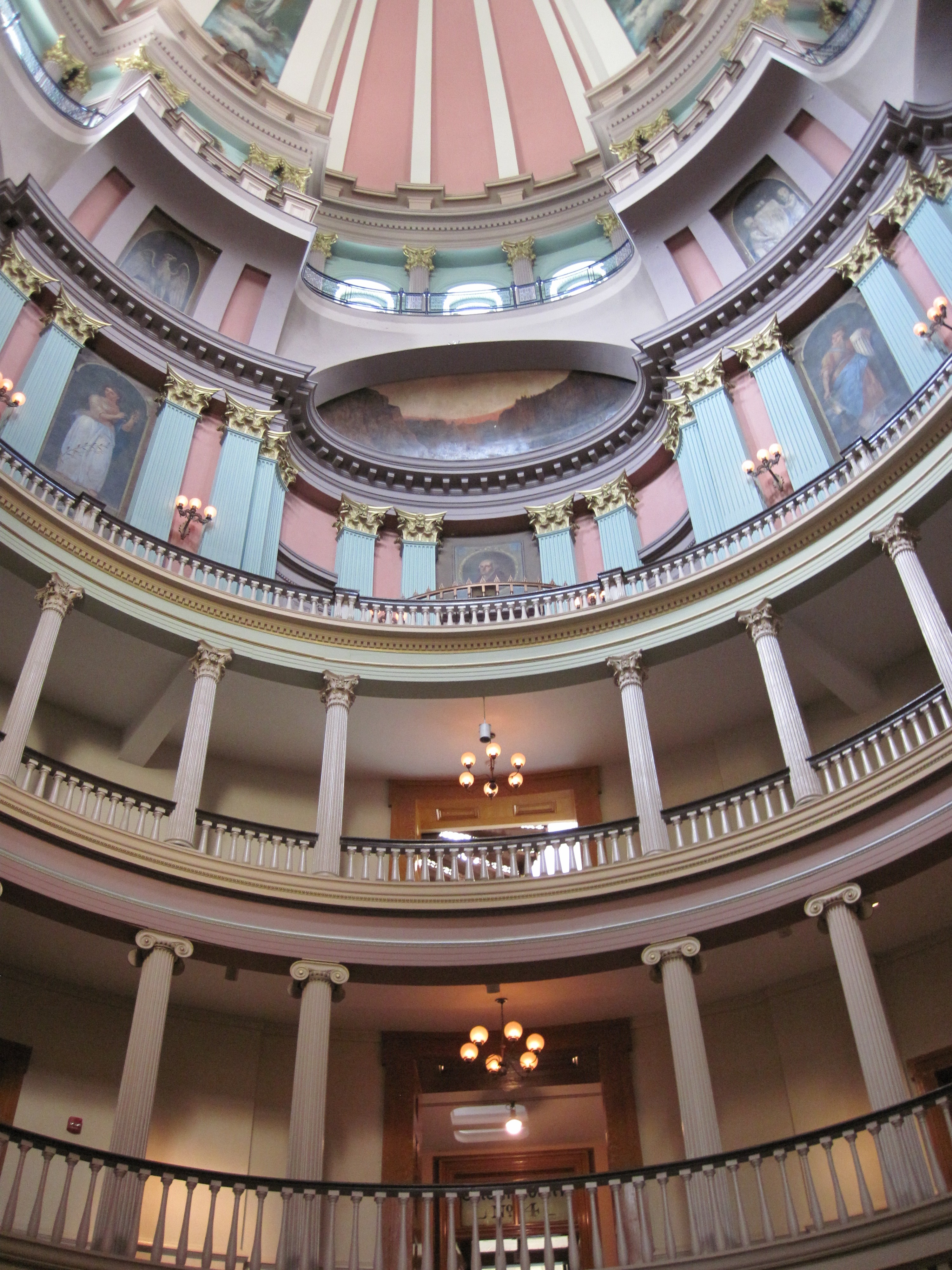
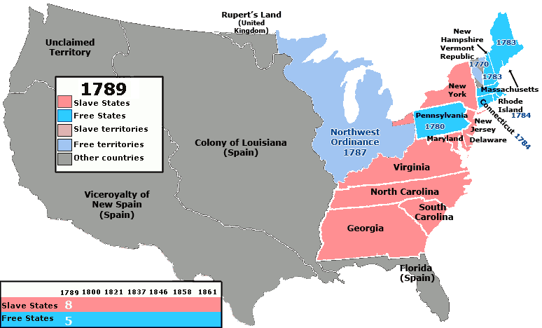
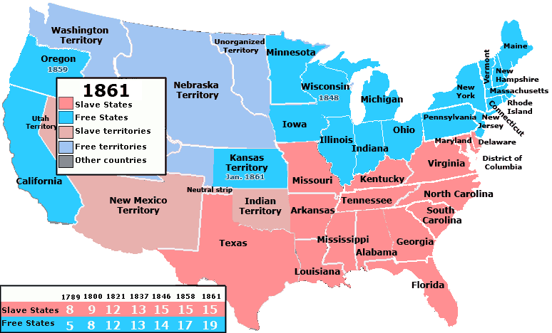
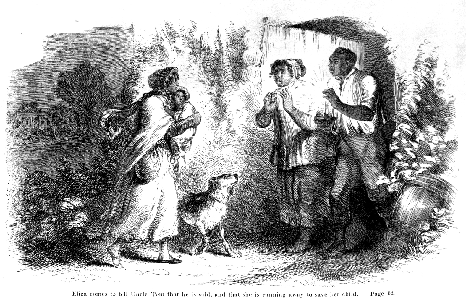
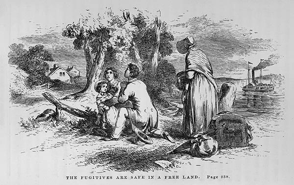
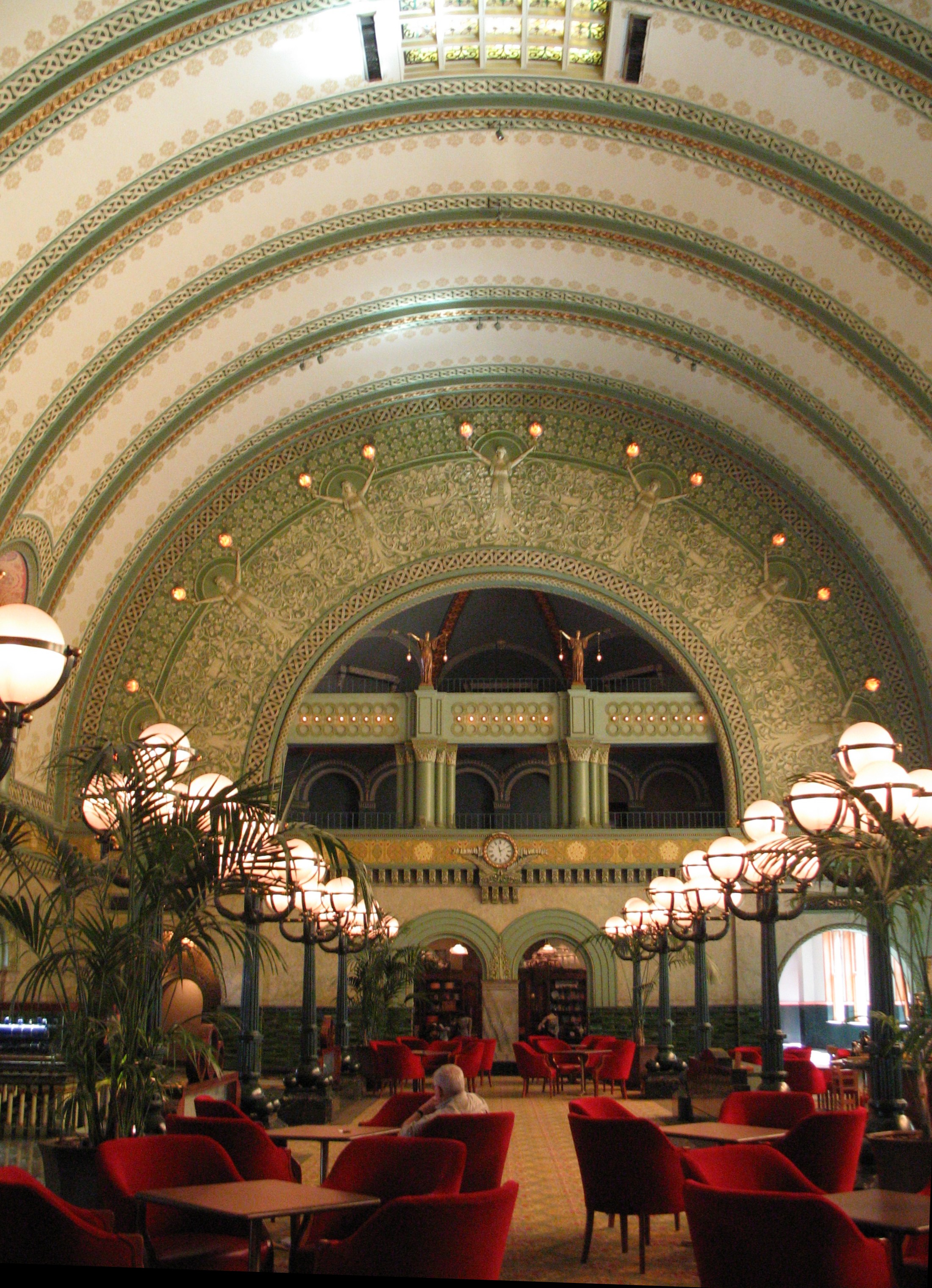
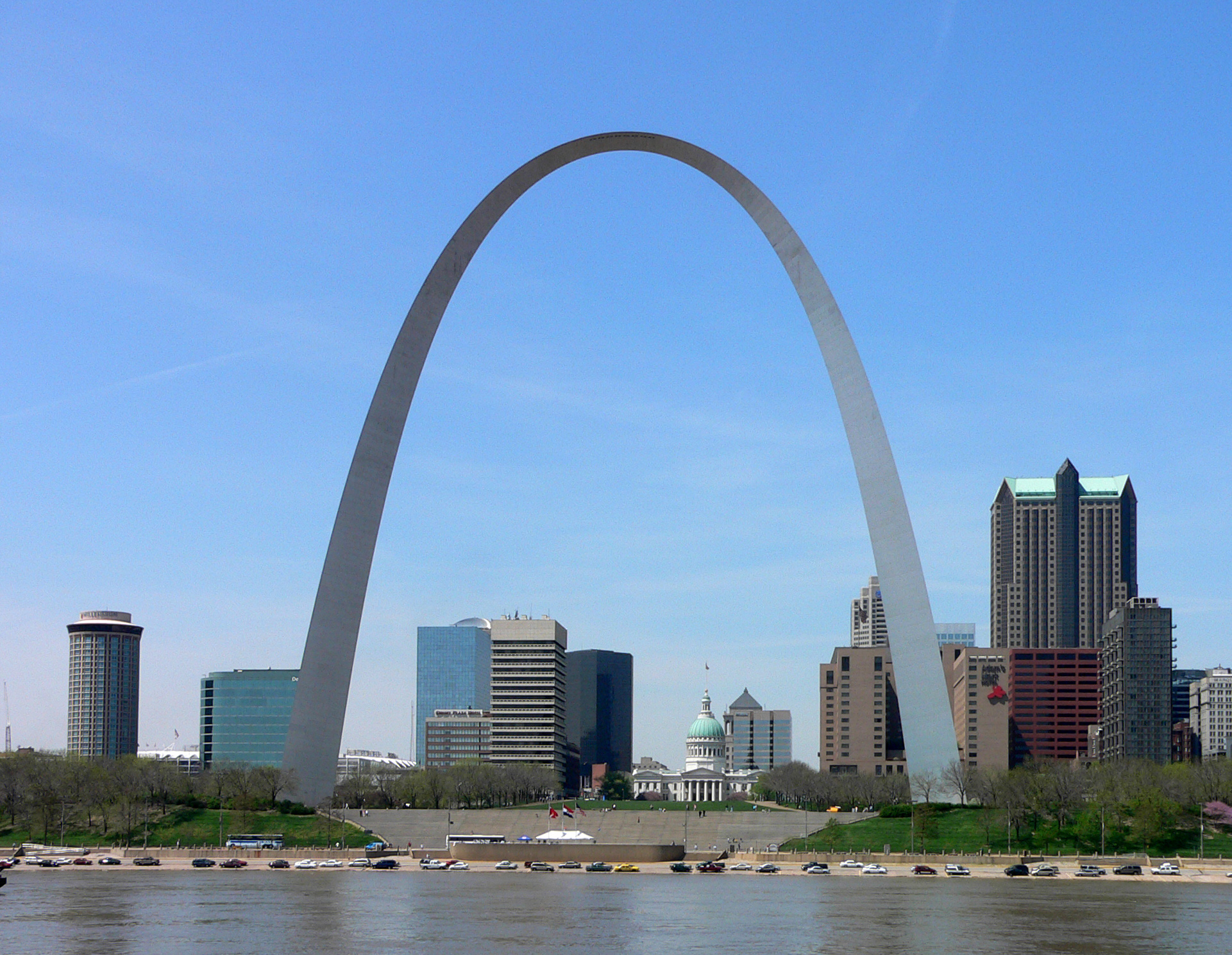
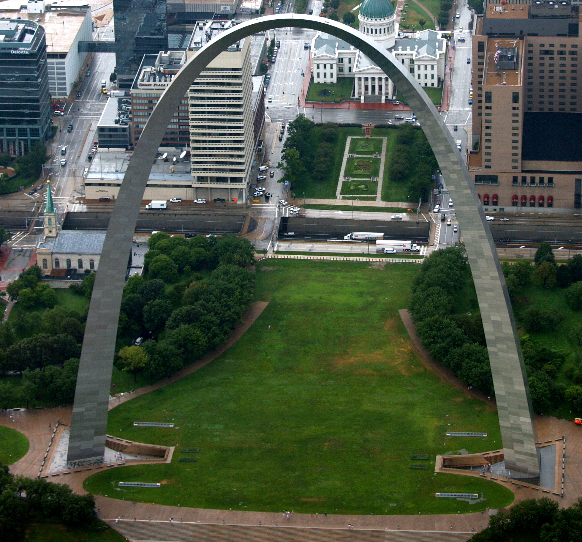
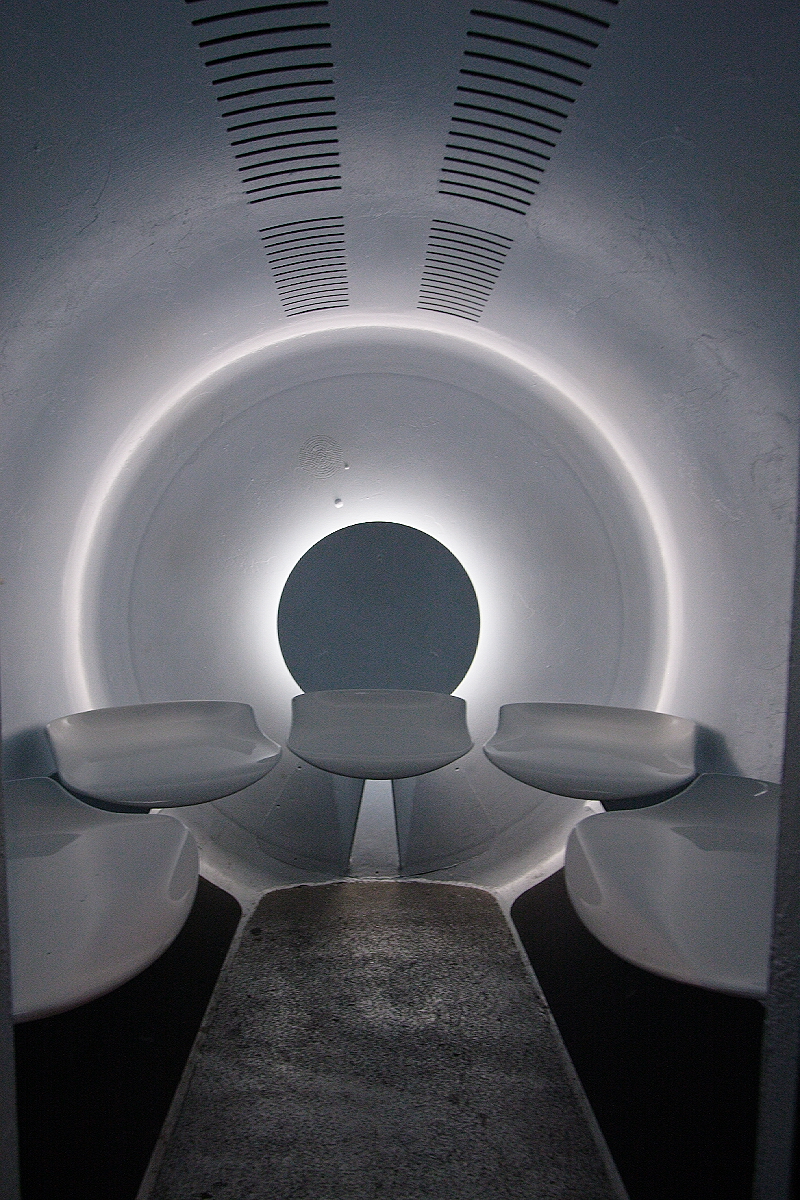
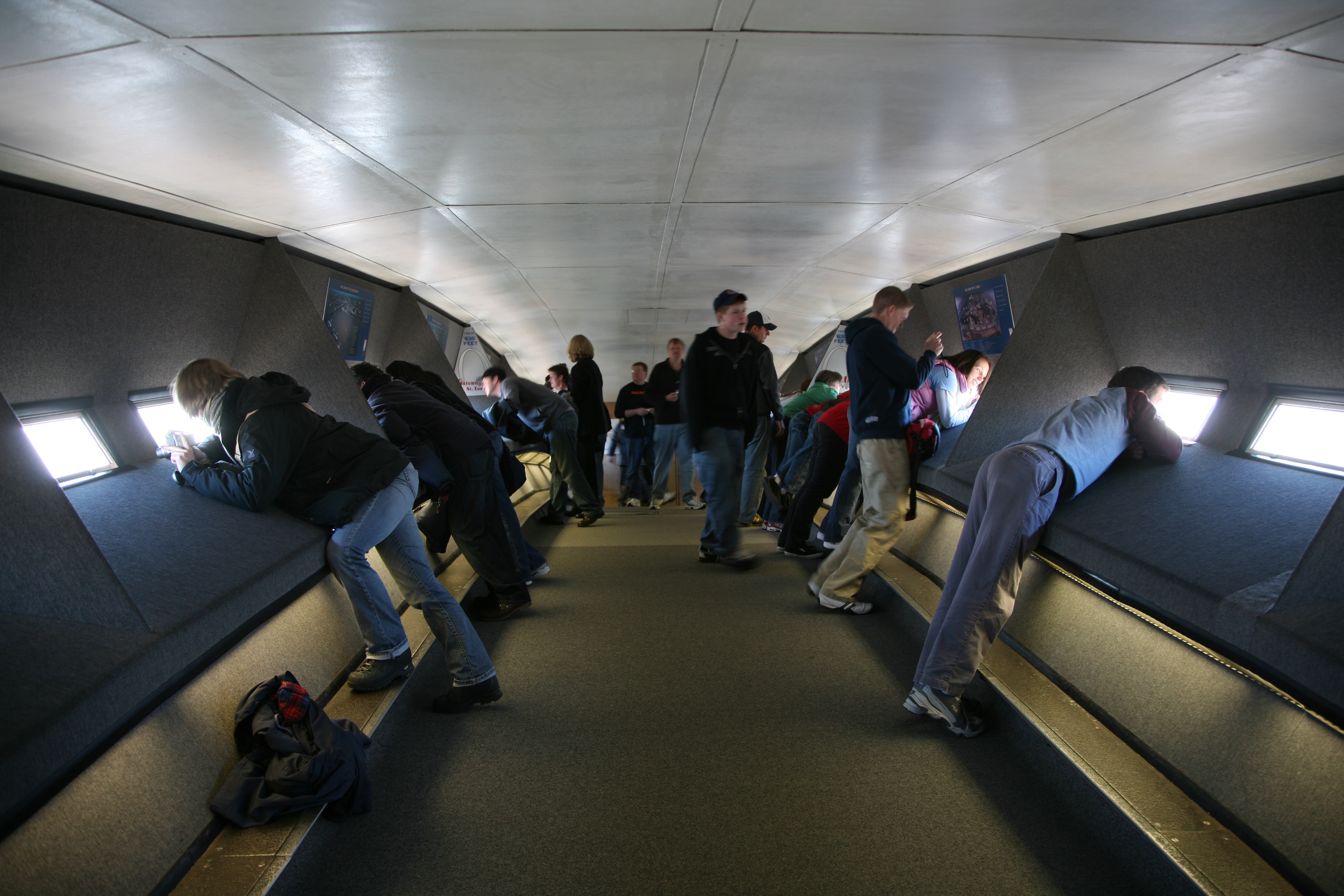
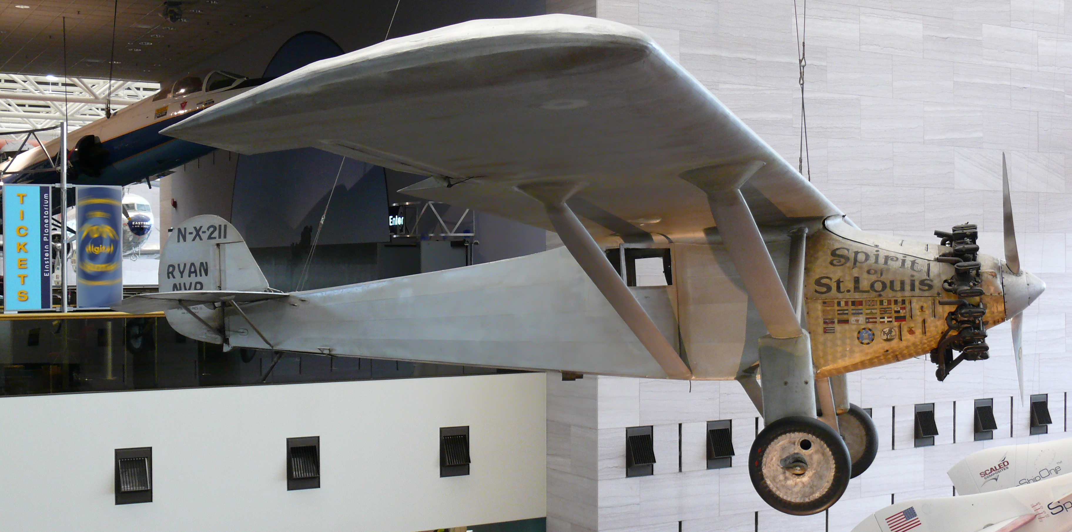