|
Reflections 2016
Series 11
July 8
East Coast II: C&D Canal – Elkton - Havre de Grace
| | One-Seat-Ride versus Three-Seat Ride We continue with the Central East Coast of the US and the Uppermost Delmarva and are about to get into the C&D Canal story, but it seems worthwhile to point out that the establishment of the New Castle & Frenchtown Railway was no pipe dream. But its competition was the Canal, and also the Philadelphia, Wilmington & Baltimore Railroad. Both of these routes offered a so-called one-seat-ride, that is no changing between Baltimore and Philadelphia for passengers or freight. On the other hand, the NC&F was a three-seat-ride, with two water routes connected by the railroad, changing in Frenchtown and in New Castle. Assuming similar pricing, the NC&F was doomed from the start. Why not go the easy way, for passengers or for freight? | | | | But we should point out that three-seat-rides—that is, a sail-rail-sail route--have historically been interesting solutions. There might have been many, but two come to mind that we've discussed in the past, the Panama Railway and the Florida Railroad. The Panama Railway connected shipping routes on both sides of the isthmus. Interestingly, before the railroad, stagecoaches over old Spanish trails were used to make the connection, again reminding that the New Castle idea of starting out with a turnpike was not totally off. Of course, the Panama Canal itself then afforded a one-seat-ride on a ship with no changing, and today the Panama Railway is, happily, used as a tourist route. For both a map of the Panama Railway, and more to the point, the shipping routes on either side of Panama, refer back to 2015/9, Ctrl-F "Shortest Transcontinental Rail Trip". | | | | But there was a route that was also on the US East Coast, the Florida Railroad, discussed in 2008/7 Ctrl-F "Florida Railroad". Since that posting was not illustrated, we'll summarize it here. In the era of coastal shipping, extensive routes were on the East Coast and Gulf Coast, but to connect them, a long trip around Florida was necessary, first way to the south, almost to Cuba, then coming back north. Worse, the Florida Strait is a dangerous body of water—consider all the colonial Spanish galleons that have sunk there. | | | | On an East Coast cruise some years ago north of Jacksonville, the first stop was Fernandina Beach. the very northernmost point of coastal Florida, facing Georgia. It was so enchanting that we drove back at a later date to stay there in a Victorian B&B. Also, we separately got to know Cedar Key on the Gulf Coast, and went there a number of times for dinner. I was then surprised that these two places were the end points for the Florida Railroad, meant to be the central connection for three-seat-rides between the Atlantic and Gulf Coasts. The railroad was acquired and changed its name numerous times in the 19C and again in the 20C, and no longer serves either of the original terminals. But this 1882 map shows it when it was using the name Florida Central and Peninsular Railroad, although the map itself indicates an earlier name still. | | | | Click on the main map to inspect the red diagonal line that connected Fernandina (Beach) on the Georgia border with Cedar Key, a route running 250 km (155 mi). This was the backbone of the three-seat system, as the route to Tampa was added much later. Even more important, click on the inset map to inspect the sea routes between Fernandina with New York and with Nassau, Bahamas. Out of Cedar Key, check the route south to Key West and Havana, and north to Gulf ports including New Orleans (via the Mississippi), Galveston, and beyond. Although a three-seat connection, this route saved almost 1300 km (800 mi) of the trip via the Florida Straits.
https://www.floridamemory.com/fpc/memory/blog/images/2013/February/tubmannefl.jpg
| | | | This detail map (click) shows NE Florida and is part of an 1861-5 Civil War era map. You can see how Fernandina harbor is well-situated. And this illustration shows Cedar Key in 1884 and how the railroad came out on a causeway to its unusual pier.
| | | | The point we're making is that three-seat, sail-rail-sail connections did work. However, the timing of the Florida Railroad was rotten. This first cross-state railroad had been chartered in 1853 and opened in 1861. Not only were there financial problems (hence the numerous name changes) but its opening date was 1 March, and Fort Sumter was fired on on 12 April. In addition, both terminals were attacked during the Civil War. It probably never got to be as useful as the Panama Railway, but that doesn't reduce its value as an interesting concept. | | | | Chesapeake & Delaware Canal We've seen that the crossing of the neck of the Delmarva as a shortcut goes back to the portages of the Native Americans. But the first person who argued for a canal was a 17C Bohemian colonist born in Prague named, in Czech, Augustin Heřman, anglicized to Augustine Herman, and how he became involved with the Delmarva isthmus is in itself an interesting journey. | | | | He was a merchant and cartographer who emigrated to New Amsterdam and became leading citizen there, but had friction with Peter Stuyvesant. Later he was sent to MD (St Mary's) to help resolve Cecil Calvert's claim to all of northern Delmarva. He was actually the first person who pointed out that the Calvert claim was only to unsettled lands, resulting in the Calverts losing Delaware. Nevertheless, Herman made a good impression on the Calverts. He was tired of conflicts with Stuyvesant and liked Delmarva, and so he offered to produce for the Calverts a map of the region in exchange for a land grant in an area of his choosing. The offer was accepted, the land grant made in 1660, he moved his family to MD the next year, and began his ten-year mapmaking project. He called his land Bohemia Manor. | | | | This is Herman's 1670 map, for which the Calverts gave him his Manor lands. It's on its side, with north to the right, but is surprisingly accurate. His portrait is on the bottom, the Atlantic is called the North Sea, and he just shows, and color-codes, Virginia and Maryland, judiciously disregarding Delaware and Pennsylvania, which shows us he very diplomatically knew which side his bread was buttered on.
http://cecilhistory.org/maps/files/canal%20map%20302.jpg
| | | | Once that map was completed, additional land grants were made so that he ended up with some 120 sq km (47 sq mi) of land, and became one of the largest landowners in North America. This last period map (click), probably early 19C, at least names his Bohemia Manor and indicates his manor house, apparently named Bayard (more about this family name later) on the Bohemia River. It's doesn't show that the manor covered a band of land in MD and DE across the neck of the Delmarva, from the Elk River on the Chesapeake, to the Delaware River. We'll come back to this "Manor map" in a moment. | | | | As a cartographer and owner of lands across the neck, Herman was among the early proponents of a canal to connect both waterways. He certainly knew the territory and could picture the benefits a canal would bring. But he died in 1686 and never saw it built.
http://2.bp.blogspot.com/-bz9aCmfTjco/UzrdAqCBUcI/AAAAAAAAAlc/g4AH_cDDzAA/s1600/01+Map1.jpg
| | | | It was in 1764 when the project was considered seriously and a survey or possible routes was made (above, click). Benjamin Franklin, of Philadelphia, was a proponent. We pointed out in the last posting that, from the Delmarva, waters flow east to the Delaware and west to the Chesapeake. You'll see from the map that every proposal included an attempt to simplify construction by connecting the two watersheds by means of local rivers and streams. | | | | Solid lines show proposed routes. An interesting suggestion would have connected the Bohemia River with a stream to the Delaware. As I picture it, it would have crossed about the center of Bohemia Manor, assuming that hadn't been subdivided yet from the previous century. Another curious one would have been out of Frenchtown, where the NC&F RR was. I like the one that would have connected Elk Town (Elkton) to the Christina River into Wilmington. | | | | The dotted lines show routes where construction took place. Welch Point is where today's canal is measured from. This one would have gone from there much further along the Christina up to Wilmington. In 1802, based on proposals in the legislatures of MD, DE, and PA, a canal company was incorporated and construction , that would have included 14 locks, began in 1804. But the project was abandoned in 1806 due to lack of funds. Do note that PA (which on this map still owns what became the DE Wedge) was involved in the planning even though the canal wasn't physically located there, since the canal being constructed was meant to primarily serve the Baltimore/Philadelphia route. | | | | But there's something else very important on this map. Not everyone realizes that canals with locks cannot be static, but have to flow. Some water source has to supply the highest level of the canal, since lockloads of water are regularly lost downstream when lock gates open for ships to use the lock. Water is also lost through leakage into the canal's banks and evaporation. As for the locks, to go "downstream", the upper gates open and a ship enters the lock along with a lockload of water. This water is then allowed to escape downstream in conduits until the ship is at the lower level. Going "upstream" a ship enters and water is dropped in conduits down into the lock from the high level to the low to raise the ship but eventually to be lost downstream as well. | | | | In the case of locks on rivers, this is no problem. On the Upper Mississippi (2016/4), the natural flow of the river keeps supplying the locks with water. On the Rideau Canal in Canada (2014/16) the highest level is a stream-supplied lake, and on the Göta Kanal in Sweden (2006/8), the canal crosses both huge lakes Vänern and Vättern, which supply plenty of water. Now look at the abandoned canal on the map, and you'll see that, to supply water to keep the canal filled, a feeder canal was being built that was to bring water from a stream to the main canal. | | | | Now look at the final route. There is no stream or central lake to supply water to the canal to keep it full, so a pumping station was needed to pump water from the low level back up to the high, and we'll investigate that during the visit. | | | | Click again on the "Manor map" and confirm that the final canal seems to run along what could be the northern edge of Bohemia Manor. But more important, check out the streams. On the east side, much of St George's Creek was used, though the route then diverged to reach Delaware City. The west side is quite different. The east end abuts right onto the Delaware River, but, because of the nature of the Chesapeake with its drowned tributaries, the route from Baltimore first enters (1) the Elk River (as does the one to the Frenchtown rail connection), and then enters (2) Back Creek, a tributary of this tributary. As it turns out, Chesapeake City is quite a ways inland from the open Chesapeake on the route. The route then continues to (3) Broad Creek, a tributary of the tributary of the tributary, and we're already into Delaware before we run out of streams to include as part of the canal.
http://images.maritimeprofessional.com/images/storage/w400/cdcanal-a.jpg
>
http://4.bp.blogspot.com/-J_aT-Myh0Gk/UzrdO2EhzRI/AAAAAAAAAlk/FvJ9imlP0gs/s1600/02+Map+old+canal.jpg
| | | | This first map above better illustrates how not all of the final canal route was or is actually within the canal. From the open Chesapeake, ships use the C&D approach channel to get to the C&D proper. The second map details the west end of the canal, as originally dug. You see that Welch Point on the Elk is an excellent demarcation point for calculating the western portal of the canal. You see how Back Creek was used to reach Chesapeake City before swinging off into Broad Creek. Note the earlier part of Back Creek that was NOT used directly for the canal. It's this water that the pumping station raised above the level of the locks. In addition, when we see the map of Chesapeake City today during the visit, you'll spot not only Back Creek entering from the SE, but a large Back Creek Basin, used as a marina, at just that SE angle off the canal. | | | | First Canal I've been using the term "original canal", so let's be more open about that. There were two canals, a second one built along most, though not all, of the route of the first. Most source will tell you that the canal was "improved" in the 1920s. You may believe that, but I say it's all poppycock (euphemism), a fable to simplify the history to a perhaps less than fully knowledgeable public. But let's do first things first.
| | | | The first C&D Canal was built between 1824 and 1829. Given the construction possibilities of the period, it was hand-dug. It was rather petite for that reason, and also explains why use of creeks was maximized. Yet its size was satisfactory, given the size of ships of the day. Back Creek was widened and altered, as was adjacent Broad Creek as well as St George's Creek at the east end. | | | | Since it was hand-dug, even though the landscape was relatively flat, they couldn't easily dig that deep, and locks were required, but nothing like the 14 locks the abandoned canal would have required. The C&D had only four locks, two at the west end in Chesapeake City and two at the east end, one in St Georges and one very close to the portal in Delaware City. Three locks were removed during the building of the second canal, the so-called "upgrade", but the skeleton of the eastern lock in Delaware City remains, and is landmarked. I was saving this picture until our visit there—and will repeat it at the time—but I show it now to indicate what size ships could use the canal. This lock, as did the others, originally measured only 30 m (100 ft) long and 6.7 m (22 ft) wide (the depth was 2.1 m [7 ft]), although they were later enlarged to 67 m (220 ft) by 7.3 m (24 ft). Though filled with water, this lock is isolated in a park today and isn't connected to anything. Picture 19C sailing ships using it, but hardly today's.
http://cecilhistory.org/chesapeakecity/CANAL%20Museum/Canal%20Open%20Sign.jpg
https://dhsbooks.files.wordpress.com/2014/10/scandehistory-com_20141013_152111_001.jpg
| | | | Note this advertisement, circa 1829, in the canal museum in Chesapeake City. You'll see that teams of horses, also mules, towed freight and passenger barges and ships, and that the company office was in Philadelphia, showing the importance of the canal to that city as well as to Baltimore. The second picture visibly presents the width of the canal. While the towpath is on the left (click), this ship is apparently steaming on its own power. The canal was larger than its locks, having a depth of 3m (10 ft) and a width of 20 m (66 ft) at the waterline and 11 m (36 ft) along the channel bottom. In any case, the impression we take with us from the lock and canal pictures is one of small size.
http://bloximages.chicago2.vip.townnews.com/cecildaily.com/content/tncms/assets/v3/editorial/6/ab/6ab1540a-98b8-11e2-9802-0019bb2963f4/515608dc91d07.image.jpg?resize=540%2C378
| | | | The Ericsson Line (brochure above) was a company that sent steamships between Baltimore and Philadelphia for 75 years through the 1940s, carrying both passengers and freight on 30 steamers, some having 70-80 staterooms, greatly increasing travel between the two cities.
https://www.cardcow.com/images/set509/card00101_fr.jpg
https://www.cardcow.com/images/set344/card00698_fr.jpg
| | | | The most popular day boat of the Ericsson Line fleet was the Lord Baltimore (what a majestic name!). Above is a 1907 postcard of her locking through in Delaware City—that would be the abandoned lock we just saw—followed by a 1906 postcard of her locking through in Chesapeake City, where no locks survive at all. | | | | Second Canal The C&D flourished throughout the 19C with the NC&F RR as its only local competitor, and that only early on. But into the 20C, ships grew in size, requiring more width and depth than the canal could provide. Traffic declined, as did profits. Something needed to be done, but little thought was given to altering the old canal. New companies were formed, and, in a reflection of earlier times, up to six possible new routes were considered.
| | | | Seeing that the canal was important nationally, in 1919 the federal government bought out the shares of the failing original private company, made the decision to close it down for eight years, and instead to build a new, improved one along its right-of way. This is the basis for saying the first canal was "upgraded", but I do not see it that way. Much of the first canal was eliminated, and the route was straightened. It's as though a thread were overlaid with a thick cable or rope (a hawser). An even better analogy is a highway one, when the 1920s system of US highways was replaced mid-century with interstates. In many locations, since the old highway had a prime location, the interstate just took it over, and the highway's number was added to the interstate's number. Where the interstate's route varied from that, the old highway remained. That's the case in so many places, but the example we've recently discussed is where "Historic Route 66" remains, connecting some interstate exits in Arizona and St Louis, for example. That's why I see this second canal as the "interstate replacement" for the first. And the replacement even left a notable "historic" remnant, at Delaware City. | | | | The 20C builders of the second canal, aka "upgrade"—that is, the Army Corps of Engineers—had power equipment the 19C builders of the hand-dug canal could only dream of. The locks were removed and a deep-draft sea-level waterway was plowed through along most of the old right-of-way. Since it opened in 1927, it's been 137.2 m (450 ft) wide and 10.7 m (35 ft) deep. It's modern and electronically controlled. It carries 40% of all ship traffic in and out of the Port of Baltimore. | | | | The fact that it's a sea-level canal, with no need to stop for locks, is a major plus. The Suez Canal is at sea level and you may recall that the original French builders of the Panama Canal unsuccessfully tried to cut through Panama's mountains to make it sea level, too, and so today there are locks in Panama. That the C&D is on a coastal plain with minimal hills is to its advantage. | | | | It's time to look at a map of the C&D Canal. If you wish to have it in a separate window for continued reference, this is a link to the same map:
https://upload.wikimedia.org/wikipedia/commons/b/b0/Canddmap.png
| | | | It's less than ideal, but the best I've found, and we can work with it. The whole top of the map, with highways and cities is, a bit confusingly, out of scale. The canal part is accurate but dated. Conrail is now Norfolk Southern; DE 896 is now part of US 301; US 13 now crosses the New St Georges Bridge. | | | | To orient us to the canal before our visit, let's do a preview of the route we'll be taking to reach Chesapeake City for the night. DE 9 gets us past—and also into—Delaware City. This is the first thing we note. Delaware City is today not on the Second Canal, but on a "historic branch". Today's canal does not bend up toward Delaware City, but goes instead straight to the Delaware River, at a place called Reedy Point. On our drive, we'll cross the Reedy Point Bridge, the Summit Bridge, and, across the DE/MD state line, the Chesapeake City Bridge. Beyond that, and for future reference, among all the confusing branches of the Chesapeake, note the location of Welch Point on the Elk River. Finally, when we leave to rejoin the Northeast Corridor westbound at Elkton, we'll take DE 213, which, by the way, is called the Augustine Herman Highway in his honor. | | | | Looking for additional information online to be able to characterize the modern C&D Canal ("Second Canal'), I found very helpful this maritime website: http://www.offshoreblue.com/ It included what they called the Blue Seas Boating and Yachting Resource Guide, on the assumption you wanted to sail your own boat through the canal. Much of the following information comes from that Guide, modified by me and supplemented from additional sources. | | | | I've avoided giving the length of the canal until now, since I was bothered, as the author of the Guide was, but the variety of answers found, since no one clarified between which points they were measuring. The Army Corps of Engineers, which runs the canal, says 17 miles, most other sources say 14 miles or so, and little seems definitive. The Guide has come up with a different number, but he specifies it's the distance between Welch Point at the mouth of Back Creek and Reedy Point. The figure he gets is 15.3 nautical miles, which is 29 km and 18 mi. I'm satisfied with that precisely calculated figure. He also points out that the Reedy Point entrance to the canal is 348 km (216 mi) from the Virginia Capes, which works out to about a 491 km (305 mi) savings in distance in using the canal as opposed to circumnavigating the Delmarva Peninsula. | | | | There are five fixed bridges and one lift bridge, which would be the railroad bridge. There are also five overhead power lines and one overhead pipeline. The minimum vertical clearance above mean high water is 41.5 m (136 ft) at the Reedy Point Bridge, with the others just a little bit higher. To compare, I checked with the bridges on New York's East River, whose clearances are very similar; the Brooklyn Bridge has a clearance of 39 m (127 ft) and most others nearby are 40-42 m (131-138 ft). | | | | I was wondering about the tides. When in the Hamptons (2011/10) we discussed the Shinnecock Canal, and when in Nova Scotia (2014/19) we discussed the Canso Strait and the St Peters Canal. All these waterways are at sea level, and yet since there are different tide cycles at either end, each has had a tidal lock built into it to control tidal movement. This made me wonder why the C&D didn't need a tidal lock, since it does have two-way tides. Apparently the tidal flow is within reason. In the canal, the tide moves eastward on the flood and westward on the ebb, and the Guide explains how to take advantage of the flow, according to the time of day. This implies to me that the tidal change is higher in the Chesapeake. Depending on the location within the canal, maximum velocities range between 1.9 and 2.6 knots, which is 3.5-4.8 km/h (2.2-3.0 mph), which is close to the average speed of a person walking, or 5.0 km/h (3.1 mph). | | | | The rules of right-of-way reflect this two-way tidal current--all vessels proceeding with the current have the right-of-way over those proceeding against the current. Beyond that, it's a no-brainer that small pleasure vessels must yield to deeper-draft vessels, which, because of their size, cannot maneuver as easily. And all vessels must be powered—sailboats are not allowed on the canal. | | | | I spotted what I recognized as a pilot boat next to a large vessel in Chesapeake City. I realized a pilot would be necessary, but I didn't realize the complicated "turf" rules until I read them in the Guide. There are two different pilots. Eastbound, for example, a Delaware River & Bay pilot boards a ship at Lewes, next to Cape Henlopen, and guides the ship just past the state line, to Chesapeake City. He then disembarks, and a Maryland pilot takes over and continues to Baltimore or Annapolis. That means that what I saw in Chesapeake City was actually a changing of pilots. And forward progress does not stop for the pilots. The pilot launch maneuvers alongside the moving vessel and the pilot uses a rope ladder, gangway, or port entrance to embark and disembark. | | | | The Guide points out that over 25,000 vessels a year transit the C&D, making it one of the busiest canals in the world. "One of the busiest" is the most definitive answer I've been able to pinpoint. Two claims I've heard about the C&D from two different sources I have not been able to corroborate, as I cannot find comparative listings, and therefore doubt them. ● One is that the C&D is the busiest canal in the US. It does beat the Cape Cod Canal, which has 20,000 transits, but the Houston Ship Channel has almost six times the transits of the C&D. On the other hand, you may argue that the Channel is a widened river bed and not a true canal. ● The other point I've heard twice is that the C&D is the third busiest canal in the world after Panama and Suez. Again, I found no definitive comparative listing, but just checking the Kiel Canal (Nord-Ostsee-Kanal) alone, Der Spiegel online says that in a recent year, it had 42,557 transits. This not only disproves what I'd heard, it also makes Kiel busier than either Panama and Suez. So the safest claim is to stick with the statement that the C&D is "one of the busiest". | | | | Delaware City We now return to our narrative. It's still the first day of our trip and we've been to Wilmington and New Castle (not named on below map) on the way to Chesapeake City, also not named but located where DE 213 crosses the canal:
http://pics2.city-data.com/city/maps3/cms3915.png
| | | | We see again that we reach Delaware City somewhat before we get to the canal. We turn off DE 9 and onto the broad main street, Clinton Street, and come to a park next to where the main eastern terminus of the canal used to be, now a "branch channel". A historic marker points out that the name Clinton Street itself celebrates canal history, since it's named after Dewitt Clinton, the governor of New York who supported the building of the Erie Canal. (We last came across his name in Clinton IA in 2016/4.) Other historic markers in and around the park, as well as the Delaware City website, explain local history, all canal-related. | | | | Uniquely in Delaware, Delaware City started out as a boomtown with the coming of the canal. From the point of view of local speculators, the canal was meant to be a door on the Delaware to Baltimore, hoping to become the primary water-based route to it, well placed to handle the traffic. At the time, it was hoped for locally that Delaware City, as a port city, might challenge Philadelphia, also on the Delaware, in population and economic importance. | | | | To this end, Clinton Street was laid out in 1826, and its businesses first were meant to cater to canal builders, and after the canal's opening in 1829, to passengers waiting for boats passing through the lock. A branch line of the Philadelphia, Wilmington, and Baltimore Railroad (PW&B), the one that had taken over the NC&F (previous posting), came via Newark DE and terminated in Delaware City. By 1900 there were street cars down Clinton Street connecting all the way to New Castle and Wilmington. | | | | The decline came about with the change in the canal. With its eastern terminus moved 3 km (2 mi) south to Reedy Point, Delaware City was no longer a port. The decline in Delaware City's economy led to the falling away of railroad service, and streetcar service was discontinued in 1930, two years after the opening of the canal. And then, we hear the same preservation story again. The abruptness of the decline contributed to the lack of funds to "upgrade" properties, and therefore to the preservation of Delaware City's historic buildings. As we arrive, this is what the area looks like (click):
https://www.lib.utexas.edu/maps/united_states/delaware_city_del_93.jpg
| | | | As DE 9 enters from the mid-left, we hang a left onto the second of the dark black lines, which is Clinton Street leading to the park with the former canal terminus, and to the Delaware River. If you look very carefully, you'll see a rectangle showing the location of the lock, surrounded, but not connected to, the current channel. Virtually the entire built-up area between the highway and river is the Delaware City Historic District, a national designation encompassing 204 buildings built in the century between 1826 and 1930. In utmost honesty, the historic district here was nice, and I applaud it, but it is not as special as the New Castle Historic District or the upcoming Chesapeake City Historic District. Pictures will follow in a moment. | | | | Leaving town, we hang another left to go see the canal. This map is the best one possible to show the narrower (though perhaps slightly broadened) as well as the much wider, straight, modern canal leading to Reedy Point and the river. An old bridge gets us over the branch channel, and then we sweep up and over the Reedy Point Bridge over the main canal. | | | | Now let's add pictures to this map study we just did. At the foot of Clinton Street, near the river, is the former Delaware City Hotel of 1828 (Photo by Smallbones), with its peaked roof. Its business came largely from its location near the Eastern Lock. We'll now repeat this picture we showed above of that Eastern Lock, whose rectangular shape you saw in the above map. It's the last remaining one of the four, which were in use from 1829 to 1919. Though containing water, it's not really connected to anything any more.
| | | | There's more to note in the above picture. Click to see in the background the Van Amringe House in the Historic District, then pan right to see the buildings on Clinton Street through the park trees. When you reach the end, you'll have an odd, gray rectangular object on a brick pedestal in the center of your screen. It had once been used for canal maintenance. Kudos if you can figure out what it is. | | | | It's a rectangular, 19C diving bell (Photo by Smallbones), used to repair the canal. See 2006/8 Ctrl-F "in 1628" for the discussion of a diving bell in Stockholm harbor in the 17C. In a nutshell, a diving bell once was an actual church bell pushed down vertically into the water and kept steady to maintain the air pocket below it. Men would then go under water and use it to breathe. This picture shows a modified version of that. While modern ones might look quite different, they're still called "bells".
http://images.marinas.com/med_res_id/34127
| | | | This is an outstanding aerial view of Delaware City that should clarify anything that's still confusing. It's taken from above the Delaware River looking roughly SW. Chesapeake City would be beyond the horizon, and the C&D comes eastward, to the left, then very notably snubs Delaware City, going off the picture to Reedy Point. The "branch channel", perhaps also slightly widened, then comes up on a diagonal into Delaware City, then has been altered to angle abruptly right into the Delaware. Between it and the park on the right we see the miniscule-seeming, isolated Eastern Lock, sitting all by itself. Yet imagine all the commerce that came through it, and how narrow the ships had to have been. Crossing the wide Clinton Street we can see the former Delaware City Hotel whose peaked roof is visible facing the river. Clinton Street then sweeps back to DE 9 in the distance.
https://c2.staticflickr.com/8/7241/6943631734_2b2396803c_b.jpg
http://images.marinas.com/med_res_id/110158
| | | | These two pictures are similar, but I like them both. The first one shows the approach to the Reedy Point Bridge crossing the old channel, then the swoop of the bridge itself, with Reedy Point itself in the distance. Given the vertical clearance we discussed pertaining to it, it's my estimate that a 13-14 story building would fit under its center. Given the flat plain around it, you can imagine that its long approach gives the feeling or going up a roller coaster. The second picture shows the same view from Reedy Point inland, up the canal.
http://images.marinas.com/med_res_id/91220
| | | | Driving over the bridge, you quickly look right and see the bulk of the canal. When you look left, you get this view of the eastern canal portal at Reedy Point. We then turn around and retrace our steps, not only for a second view from the bridge, but because we want to go west to Chesapeake City along back roads lying to the north of the canal. | | | | A Tale of two "Cities" We deal here a lot with names, since so much can be gotten out of doing so. The following is based solely on conjecture, with no solid back-up facts, but the matter seems quite clear to me. First question: where did Delaware City probably get its name?
| | | | That sounds like a no-brainer. Surely from the state of Delaware, right? After all, we see the relationship between Oklahoma City and Oklahoma, Jersey City and New Jersey, and internationally Panama City and Panama, Mexico City and Mexico. But I say probably not. Next thought: it's named after the Delaware River. I say "warmer", but I think that's not strictly speaking so, or at best, only indirectly. | | | | Maybe we can get a clue from Chesapeake City. Where Delaware City was started from scratch, Chesapeake City already existed under another name, and was willfully renamed. But wait. Chesapeake City isn't really on the Chesapeake, or at least, not on the open bay. At best, it's on a tributary of a tributary of the Chesapeake. As Delaware City is not directly named for the River, Chesapeake City doesn't really seem to be named for the Bay. | | | | One last clue is in the use of the word "city". Delaware City in 2010 had a population of only 1,695. Chesapeake City only 673, or 40% of DC. They at best are towns. Why were they named cities? | | | | The "educated" presumption I make is this. Both towns were named after the C&D Canal! Delaware City was named, and Chesapeake City renamed, just about when the canal arrived. Delaware City is therefore not named after the state, or directly after the river. Its name is an announcement that it's at the eastern portal of the canal. Similarly, Chesapeake City designates more or less the western end. I think the use of "city" in their names reinforces directionality along the canal more than any potential hope for future urban growth. | | | | Which brings up the issue of poignancy. Chesapeake City is still on the canal, at the western end, but Delaware City is no longer at the eastern end. I may be over-romanticizing this, but Delaware City is like the abandoned wife whose husband has run off to shack up with a younger woman, seductively named Miss Reedy Point. Worse, they didn't move far away, but tauntingly live just down the road from the abandoned, older wife. Well, thus is life.
http://www.johnweeks.com/c-and-d-canal/pics/summitbr01.jpg
| | | | Chesapeake City The back roads though are tricky. While we intend to stay on the north side to cross over the Chesapeake City Bridge, when we come near the Summit Bridge (above, also see canal map), it seems judicious—a bird in hand—to cross here instead.
http://mht.maryland.gov/nr/map/nrb230.jpg
| | | | But the local roads on the south side are also confusingly marked, and, instead of reaching Chesapeake City from the east (see above map), we find we've swung south and arrive in a northward direction. We'll get a better map in a moment, but this one shows a lot. First, that the canal splits contemporary Chesapeake City, with the north bank being less interesting and the south bank, with the historic core, being of great interest. For that reason, the tiny historic district, bounded here in blue, is actually called the South Chesapeake City Historic District. | | | | Coming from the south, note the bridge interchange. We decide to pull to the right and go into town for a quick look-see, but then, still having time, we backtrack and go over the bridge to get, quite literally, an overview. The bridge is so large that the interchange on the north bank is far enough away to not even fit on this map. We look around a bit, going down to the canal's edge, then return and enter the south bank of town, our destination. | | | | | | While this map is handy, note some other details. From the lower right, what else enters the picture but the remaining part of Back Creek! It flows into a widened section used as a mooring basin, and actually a marina. Adjacent to it on the canal is the Pump House Museum, which appears as a black rectangle. |
| | | | I point out the bridge situation here for the reason that it's made a big difference. There had been a wooden swing bridge over the first canal connecting two points in the center of town, George Street on the south with Lock Street on the north. Then the second canal was built, so the wooden bridge was replaced between 1924 and 1928 by a vertical lift span, where the center section rises to let boats through, like the Stillwater Lift Bridge in Minnesota (2016/9). But this bridge was destroyed in 1942 when an oil tanker being towed by a tug plowed into it. | | | | There was no bridge at all and only ferry service for eight years, until 1949 when the present high-level bridge was built. But as our map shows, this bridge was instead built about 152 m (500 ft) west of the center of town. As the Chesapeake City website explains, this bridge had to be tall enough to allow supertankers to pass beneath it, resulting in a structure so high and so long (we just saw that at Reedy Point as well) that cars no longer went into town to cross the canal, and business declined for decades thereafter. I can tie that in with the shocking fact told me by Bob, the innkeeper at my B&B. By the 1960s what is now the historic district had become a run-down, crime-ridden area. Locals resolved to turn it around. The crime is gone, and most buildings are beautifully restored. | | | | We've gotten ahead of ourselves talking about bridges. The town was originally named by Augustine Herman as Bohemia Village, and the main street to this day is still called Bohemia Avenue. According to the Chesapeake City website, when the canal was completed in 1829, there were only 2-3 buildings in town, all on the south bank, one of which was a pre-revolutionary tavern. A decade later, in 1839, Bohemia Village was renamed Chesapeake City to proclaim its new status, and another decade later, in 1849, the well-established town extended to the north bank and was at its population peak. All was well for ¾ of a century, when the second canal was built, opening in 1927. With no locks, there was no longer a need for ships to stop here, and the economic decline set in. The bridge destruction in 1942 made things worse, and the new bridge in 1949 was the last straw, since travelers swept by high above the town. And then, now for the third time, we see that economic decline ("poverty") is the mother of historic preservation, and buildings from the 19C dominate the historic district over the few of the early 20C and later. The district is on the National Register of Historic Places.
http://chesapeakecity.com/wp-content/uploads/2015/02/chesapeake-city-map.gif
| | | | This is the outstanding map available on the Chesapeake City website. The petite concentration of the historic district makes it very cozy—everything is right there! Click to first confirm that the main street is Bohemia Avenue. Find nearby George Street, which is of minor importance today, but consider how things were when the earlier bridges connected George Street across the canal with Lock Street; the whole town dynamic would have been so different. Without the connection over the canal, each of these two streets is now a dead-end backwater, with the high-level bridge usurping all traffic. On the lower right, reconfirm how there still is a bit of Back Creek, entering what is here called the Back Creek Basin, with the museum on its north side.
http://www.chesapeakecity-md.gov/wp-content/uploads/2014/06/bridge-colorful.jpg
| | | | Hold on to the town map, since we'll be referring back to it, but also note this aerial view of Chesapeake City. The height and length of the bridge we've already discussed. You can see that there's less of interest on the north bank, and also how Lock Street today comes to a dead end at the canal where it used to lead to the (low-level) lift bridge. Estimate where George Street also dead-ends on this side between some trees. We'll do a walking tour of town in the morning, but for now, let's point out what we can in this overview. Find the large brick building to the right of George Street. It's at the end of Bohemia Avenue, on the east side. Closer to us is tiny 1st Street, then another building. After that is a large, gray-roofed, greenish building, which is the Inn on the Canal, our B&B. Finally, across the street from the brick building (to its left), is a large dark-roofed building. This is the Bayard House, where we'll have dinner both nights. Confirm its location on the town map, and we'll discuss it more below. | | | | When we arrive, we easily find our way to the Inn at the Canal (see map), a c1870 house in Victorian Gothic style. Talk about location, location, location. Innkeeper Bob is waiting, as we've been corresponding over the last few days about my arrival. Bob's a CIA (Culinary Institute of America)-trained chef, so breakfasts will be notable.
http://www.innatthecanal.com/images/images/content/DiningRoom.png
http://www.innatthecanal.com/images/images/content/RoomsandRates_LivingRoom.png
| | | | There are large public rooms downstairs, and Bob and his wife live in the back. Above are the dining room and living room. Late afternoon complimentary coffee and pastries are served. I comment about the streets being so empty that I got an (angular) parking place right at the front gate. Bob assures me that's because it's early season, and midweek. Weekends are much busier, and the summer is quite busy all the time. As it turns out, I'm the only guest today, although on the second night, another room of the available seven will be occupied. As is common in B&Bs all the rooms are named. I had booked the least expensive one, but Bob had told me by email even before I left New York that he's giving me a free upgrade. (Travel off season!) The room I get is one of four at the highest rate (other than a suite), which is the equivalent of a 26% discount. Better still, the room is named Back Creek, which resonates historically with me. Here are two views of the room. Above the queen canopy bed is a picture window that looks out over the back of the house to the Canal, eastbound, and the basin (see town map).
http://www.innatthecanal.com/images/images/content/rooms/BackCreek/IndividualRoom_Portrait_BackCreek_1.jpg
http://www.innatthecanal.com/images/images/content/rooms/BackCreek/IndividualRoom_Portrait_BackCreek_2.jpg
| | | | We discuss restaurants with Bob and he recommends the Bayard House, which could hardly be closer, just across and a bit up Bohemia Avenue. We'll have pictures of everything when we do our town walk in the morning, but for now we can discuss background. You'll note on the map the reference to the Hole in the Wall Bar. The building is on a slope down to the canal, with the restaurant upstairs and bar downstairs. Referring back to that pre-revolutionary tavern we mentioned earlier, the lower part of the building is it, dating to c1780. We peek in, but the bartender is alone middle of the week, so we go upstairs to the restaurant. The inside room is empty, but there's a glassed-in terrace with views up and down the canal, and of the bridge overhead, and this area is hopping busy. I dine here both nights, and one night I had to have Maryland crab cakes, so traditional on the Eastern Shore. This picture shows how they're served and garnished at the Bayard House:
https://media-cdn.tripadvisor.com/media/photo-s/08/4b/c5/aa/bayard-house-restaurant.jpg
| | | | But we've seen the name Bayard before as the name of Herman's Manor House on the Bohemia River, and so it seemed worthwhile to delve into the name. And what a background! This is the short version. The name came to the US starting with the death of the French Huguenot Samuel Bayard in 1647. That same year, his widowed wife, Ann Stuyvesant Bayard, came to New Netherland with her brother, Peter Stuyvesant. Her grandson, also named Samuel Bayard, went to Bohemia Manor, Maryland, in 1698. | | | | The Bayard House, because of the tavern on its lower level, is considered to be the oldest building in Chesapeake City. The Bayard name first appeared in the history of the building in the 1780s via yet another Samuel Bayard (1767-1840) who was a lawyer and judge. He built the original structure in Bohemia Village, apparently incorporating the tavern. It was later sold and resold, then resold again, this time to Richard Bayard, a descendent of the original owner. It was during his ownership that it became known as the Bayard House Inn. The prominent family was deeply involved in politics. It yielded five US Senators from Delaware serving from 1789 to 1929. Well before that, Nicholas Bayard, a nephew of Peter Stuyvesant, was the 16th mayor of New York City in 1685-1686. All in all, the Bayard House was a great place to dine because of the good food, great views, age of the tavern below, and prominence of the family. | | | | Day 2: Chesapeake City Our first full day in town involved the museum and then a self-directed walking tour through town, which still left time to relax in the afternoon. Rather than walking way out to the museum, I took the car down 2nd Street (see map) and around Back Creek Basin to the property belonging to the US Army Corps of Engineers, which operates the canal, and also operates the C&D Canal Museum, often referred to just as the Pump House Museum. It was this building that I particularly recall from our first fleeting visit at the end of the 1981 trip. Actually, I'm not sure we went into town on that visit, obviously a mistake. | | | | As explained, the pump and its house were only needed for the first canal, to pump water from Back Creek to the part of the canal higher than the locks. Afterward, no locks--no pump needed. Even the fieldstone building of the Pump House (Museum) (Photo by Acroterion) is strikingly handsome. This is the north side, that faces the sidewalk along the canal itself. In this picture, the water wheel is in the center, as the rounded window implies. On the left is the boiler room that produced the steam for the engines. The two 150 horsepower (110 kW) engines consumed eight tons of coal daily while lifting 170 tons of water per minute into the canal. The original, smaller pump house is on the right, and now shows various displays and exhibits, such as the below map of the long and short routes around the Delmarva, where the canal saves one full day between Baltimore and Philadelphia. (The museum's windows are reflected at the top.)
https://greatloopadventure.files.wordpress.com/2015/05/aaaacc-map.jpg
| | | | This is the floorplan from above. Click to inspect what we've just talked about, and also see the lift wheel with its two steam engines from above. Even better, this side view of the lift wheel and the older steam engine shows how graceful the wheel as well as its twelve bucket-like scoops were that lifted the water up to the raceway connecting to the upper part of the canal. The iron and wood waterwheel measures 12 m (39 ft) in diameter and 3 m (10 ft) in width. Below is an overall sketch of things as things looked back in the day, when the wheel was in operation, for the nine decades between 1837 and 1927 (click):
http://3.bp.blogspot.com/-wslxHZ76GsQ/T8bFKpOEoJI/AAAAAAAADMA/Kt3k4OdY-FM/s1600/IMG_3861.JPG
| | | | | | It's interesting to make a comparison of how similar things can still be different. Last year on the American Queen on the Mississippi, we saw how a steam engine turned the paddlewheel. In that case, the paddlewheel is fixed to the boat, and interacts with the water to propel the steamboat. In this case, the lift wheel is fixed to the ground, and the paddles interact with the water to move the water instead. Still, the principle is the same. |
| | | | It's extremely hard to find pictures of the wheel and engines. It's hard to judge from this view of the interior of the pump room (Photo by Acroterion) just what you're seeing (click) other than the original of the above sketch. Yet what impressed me in 1981 and again now is how well the machinery is displayed, so clean and painted, almost as a still life. | | | | I suppose what impressed me about this museum in 1981 stayed with me. The Pump House, dating from 1837, is one of the first National Historic Landmarks to recognize an engineering achievement, particularly from this early a period, rather than an important building or place associated with an historic event. For instance, the Brooklyn Bridge is also an engineering achievement, but it's also an architectural achievement and dates from much later, 1883. I think that I came away from this museum in 1981 with a greater appreciation for the topic, particularly for steam engines, as we discussed on lake steamers on Stockholm's Lake Mälaren (2006/8), on Lake Lucerne (2008/16) in Switzerland, as well as on the American Queen last year. | | | | Back in town, it was time for our self-directed walking tour. But first, it seems worthwhile quoting this statement I found on the form for the historic district nominating it to be listed on the National Register of historic places: Today, the largest remaining segment of the original town is found on the south side of the canal where several streets of almost unaltered mid to late nineteenth century buildings still stand. Overall, this area retains an authenticity impossible to recreate in any modern construction. It is a part of both national and local heritage, a vital anchor very much needed for the cultural health of the community and the public at large. | | | | The walk is easy, as the town is compact and highly walkable. Check the map to confirm that the main intersection is 2nd Street and Bohemia Avenue. The most interesting area is upper Bohemia, from there to tiny 1st Street, then to the canal. We'll concentrate here on this on this walk, but leading up to doing that, we'll first stroll down Bohemia between 2nd and 3rd, which, like upper Bohemia, has historic houses, almost all of which have explanatory plaques, plus shops and restaurants.
http://chesapeakecity.com/wp-content/themes/chesapeake/backgrounds/bg2.jpg
| | | | This outstanding overview, apparently from the bridge, shows perfectly our area of concentration on this walk. It looks to the SE, with Back Creek flowing into the Basin. On the left is the Army Corps of Engineers area, with the museum just off the picture. The buildings we're looking at are on Bohemia Avenue, running left-right, although I suspect parallel George Street might be hiding under the trees in the foreground. While we'll concentrate on the overview, keep flip-flopping between it and the map, as we'll be referring to each. | | | | The green-roofed brick building (click) on the right is the current town hall, rather undistinguished in architecture. But opposite it, with the blue roof (map #8) is a most interesting building, which this picture does not do justice to, so use some imagination:
http://l7.alamy.com/zooms/7b3c5ea981c24c2cbd3a5fcd4d246b06/chesapeake-city-town-hall-maryland-cw45c0.jpg
| | | | The rust stains are no longer on the granite stonework, which has been beautifully refurbished. The marker on the right explains that this building had been built as a petite, but distinguished bank. At one point, as you can see, it also served as the town hall. But it is now a gift shop (!!) called My Jewelry Place. I'm not big on gift shops, but I had to see this. The lower floor, plus a large loft area, is all used for jewelry displays. But the very best is the vault. Further in on the main floor the massive, round door to the vault stands open, and you can step inside to see more jewelry, which now somehow seems more authentically shown in a vault! Lotsa fun. Next door (map #7) is Canal Lock Antiques, in a handsome building that seems to be a converted residence (first picture below).
https://s3.amazonaws.com/antiquingondelmarva/wp-content/uploads/2015/09/25100624/canal-lock-antiques-2.png
https://media-cdn.tripadvisor.com/media/photo-s/01/e2/cc/45/inn-at-the-canal.jpg
| | | | Back to the overview. To the left of the town hall, beyond the tall, pointed tree, is the peak-roofed Inn on the Canal, our B&B, in shades of green (also, second picture above). Our car was parked right where this one is, near the massive tree and at the garden gate. There's a historic marker up front, as there are on most of the houses down to 3rd Street, telling about the house and family history. From the style of the building, this had been the home of a wealthy owner. But of particular interest is the tiny structure that shows up on the left. As Bob explained, while today having a home office is considered perfectly normal, back in the day, it was considered unseemly, so it became the style to have a tiny office out in the garden for the purpose of conducting one's business. This one, at the edge of the Inn's property (map #6), is the last one of several remaining in town. Bob rents it out to a woman who sells local handicrafts and operates it as Mary's Palette, the "Smallest Gift Shop in Chesapeake City" (first picture below, with the Inn on the right) .
http://www.foodielovesfitness.com/wp-content/uploads/2015/08/Marys-Palette-Chesapeake-City.jpg
http://chesapeakecity.com/wp-content/themes/chesapeake/backgrounds/bg3.jpg
| | | | The second picture shows, following the Inn and tiny boutique, the Back Creek General Store (map #5), a restored 1861 building now selling gifts, with its original name prominently displayed. It's also easily recognized on the overview. It would seem that, back in the day, a general store would be quite central to the community. To the left is 1st Street and the brick building that is very noticeable on the overview. It's probably the most splendid building in town, and there are several ways to reference it. My favorite is the traditional name, Franklin Hall (Photo by Smallbones). It's also called Chick's, based on the shop there, and the Masonic Hall. We need clarification. | | | | The history I've read was that, when the first canal was completed in 1829 there were just two structures standing in Bohemia Village, a lock house for collecting tolls and a pre-revolutionary building known as Chick's Tavern. The Bayard House on the west side of the street claims that its Hole-In-the-Wall Bar on it lower level was originally Chick's Tavern. Then I consulted the Maryland Historical Trust entry on Franklin Hall, on the east side of the street. They mention a Mrs Mary Chick as being the Tavern keeper of Chick's Tavern before 1800 and that it probably existed during the Revolutionary War, since several members of the family took the oath of allegiance in 1781. Although they state that Chick's Tavern was on the land where Franklin Hall now stands, they modify it by saying the exact location is uncertain, although it was surrounded by all the outbuildings necessary for the care of travelers and their horses. They also say that Chick's Tavern and later the Bayard House were popular gathering places. | | | | Now the boutique on the main floor of Franklin Hall calls itself Chick's (map #2), and adds "formerly Chick's Tavern". That cannot be. At very best they can claim it was the SITE of Chick's Tavern, which is possible, but doubtful. Upstairs in this marvelous building is Alexander Historical Auctions (map #4), dealing in historic militaria and important letters and documents. The building had many other uses (meeting hall, library, hardware store, stable in the back) and the Masons bought in 1948 for meetings for a period of time. Of all the names, I prefer Franklin Hall. | | | | The Maryland Historical Trust states: Architecturally, Franklin Hall is one of the most significant structures in town, due not only to its [substantial] brick construction, but also the Romanesque style, unique to the town. It had been built in this style c 1870 using locally made bricks and was restored in 1974.
http://www.foodielovesfitness.com/wp-content/uploads/2015/08/Chesapeake-City.jpg
| | | | Finally, on the overview find the Bayard House opposite the Hall, but up by the canal, the building between the two trees. Then compare it to the above view of that side of the street showing a pleasant streetscape, as well as the Old Gray Mare Gift Shop (map #1). But the Bayard House is the last building, where the street dips abruptly down the bank to the canal.
http://4.bp.blogspot.com/-c0sJGf_Y6Bg/VKVlQ5d7CaI/AAAAAAAAbhg/4X7IJbaopFU/s1600/DSC03035.JPG
https://media-cdn.tripadvisor.com/media/photo-s/02/e7/17/12/bayard-house-restaurant.jpg
| | | | The first picture is the Bayard House straight-on with the historic Hole-in-the-Wall Bar down below, closer to the canal level, and the restaurant above. It's obvious what nice views the glassed-in terrace has of the bridge and canal; the second picture is a detail from inside the terrace. | | | | | | I think it's obvious how I relish these historic districts, but I have to keep on telling myself that, as great as it is, everything here is recycled, and therefore faux reality. A large aspect of the essence of historic preservation is that few things really are as they seem: everything is real and nothing is real. These are 19C buildings in 21C guise. Few people live in these houses, and no original businesses, such as the general store, are there. They're all gift shops, restaurants, and B&Bs. To what extent are we really experiencing the past? Not very much--and I love it anyway. But there is some reality in our otherwise fantasyland. There are some private historic homes here, even right on Bohemia Avenue, as there were some very nice "really lived-in" ones in St Genevieve last year (2015/8). It's really quite reassuring to find these, showing that 19C reality can really blend into 21C reality. |
| | | | What have we been missing here along the canal? Ships! During our visit late yesterday and this morning there's just been little more than small pleasure boats going to and from the marina. But here we are at noon, finished seeing what we want to see, standing with four or five other visitors at the end of Bohemia Avenue on the Bayard House lawn, expecting no more than to have a relaxing afternoon writing at the Inn, then coming back for a dinner here a second time. | | | | And then, at the last minute, it happened. You'd almost thing I'd had it scripted along with the other carefully laid plans. A foghorn blasted to our right. We turned to see a blue-and-white elephant—no, mountain--slowly moving westbound towards us. What I recognized as a pilot boat seemed like a toy at its side. At the time, I thought a pilot was leaving, but we now know it's an exchange of pilots here instead. The mountain moved slowly past the Bayard House and several of us joked that we thought it wouldn't fit under the Chesapeake City Bridge. Of course, it did, but from the ground, it certainly looked close, though I'm sure it wasn't. | | | | And I say that to make a point. I often see from my windows big passenger ships going downstream the Hudson, also right to left (they go upstream at dawn), but my windows are at 6-7 stories, perhaps closer to "eye level" with the ships. But at the canal, if I were any closer to sea level on the lawn, my feet would be wet. Also, the Hudson estuary is estimated to be 1,500 m (5,000 ft) across and the canal is only 137.2 m (450 ft) across, so the bulk of this mountain sailing down the canal really stands out. It's like an elephant tip-toeing down a garden path.
https://www.hafen-hamburg.de/images/image_cache/images/0/fotos/schiffe/9182277.jpg
| | | | But this is the 21C, and the internet tells all. After being impressed by what I saw, I repaired to my laptop in the Inn, putting aside all thoughts of writing right now, but instead to get more information, based on my having noted that the freighter was called the Cassiopeia Leader (above). It's not shown sailing here in the C&D, but look at the link (clues are everywhere!) and you'll see it's connecting with the Hafen (harbor) in Hamburg, so she's shown here sailing either up or down the Elbe. | | | | | | A quick online mythology check points out that Cassiopeia (Κασσιόπεια) in Greek mythology was a queen of Ethiopia and mother of the princess Andromeda (Ἀνδρομέδα)—both have made it into the sky as constellations. As for the words themselves, note these variations in stress: while we stress Cassiopeia like "María", look at the Greek spelling—letter by letter if your Greek alphabet recall is weak--to see that in Greek the O is stressed; and while we stress Andromeda on the O, Greek stresses the E. I suggest saying them out loud so you clearly hear the difference. It's great intellectual exercise to blend classical mythology, astronomy, travel, and language study, and all based on spotting a freighter! |
| | | | As you can see in the picture, the freighter belongs to the NYK Line. It's revealed online that the N stands for Nippon, so it's a Japanese company and ship. It was built in 1999 at 57,455 tons. It's 200 m (656 ft) long by 32 m (105 ft) wide. Since, once again, the canal is 137.2 m (450 ft) wide, it's just under a quarter of the width of the canal. However, it's draft is 10m (33 ft)—depending on the varying weight of its cargo, of course—so the canal's depth of 10.7 m (35 ft) comes a little close. Hence the pilots, to make sure she doesn't end up inside the Bayard House terrace.
http://www.autonews.com/apps/pbcsi.dll/storyimage/CA/20131013/OEM01/131019963/AR/0/2.jpg
| | | | I also read that it's a vehicle carrier (above), and so big that loading cars takes 20 hours. The picture also shows that it's a RORO vessel. If you don't know that term, don't panic, I just learned it relatively recently myself. It simply means "Roll On, Roll Off" and indicates that it handles cargo that doesn't have to be lifted on and off the ship by cranes., such as containers do. The NYK website boasts of a "fleet of 123 RORO vessels, mainly [in] our superior Leader Class", which carry over 3 million cars annually across the globe, each ship carrying up to 7,500 standard-sized cars.
http://bloximages.chicago2.vip.townnews.com/cecildaily.com/content/tncms/assets/v3/editorial/4/78/478c6b2e-418a-579f-b6d1-4719dddd0eab/522909f530df2.image.jpg
| | | | But the picture we want to see is this one, right? Our blue-and-white mountain (elephant?) sailing westbound under the Chesapeake City Bridge, right off the front lawn of the Bayard House, which is exactly as we saw it. Will the smokestack clear the bridge? Of course it will. Well, you can find anything on the internet, and this picture is pretty close to perfect. However, we need some full disclosure. A really close inspection of the picture will show that this is actually a sister ship, the Horizon Leader, built in 2010, but having the same length and width. | | | | But we're not done. We also consulted what was called a "vessel tracker" online and checked where the Cassiopeia Leader had been, and where she was going. We picked its route up some time back, when she went from Australia to Japan. More precisely, she went from Melbourne to Yokohama, and her next stop was Colón. Colón is on the Caribbean/Atlantic side of the Panama Canal, which means she crossed the entire Pacific first. The stop after that was Baltimore, indicating a trip up the US East Coast and through the Virginia Capes and Chesapeake Bay. Later on in the trip, when we ourselves sailed into Baltimore harbor, Harold, the online lecturer, pointed out among other things, that auto transport accounts for a huge percentage of business there. It was good to hear, as it connected the end of the trip with this canal event in the beginning. | | | | After Baltimore, the Cassiopeia Leader went to Port Newark. That NJ location, along with Port Elizabeth, accounts for much of the traffic in New York harbor, and I can see their cranes in those two places behind the Statue of Liberty out my window. This means that the ship recently crossed through the C&D eastbound, went out past the Delaware Capes and around New Jersey to New York harbor. Now, watching her here on the canal, we know that she left Port Newark two days ago, retraced her steps to cross the C&D again, westbound, and is due back in Baltimore today by 13:00. What an adventure we've had on the C&D Canal! | | | | Day 3 (early): Elkton, Havre de Grace We leave Chesapeake City today for two nights in Gettysburg, with two stops on the way. We have to start out going south, the wrong way, on George Street just to get back enough distance to get on to the Chesapeake City Bridge again, since it's so long to go so high. Take another look at the canal map to see how we start out. MD 213, the Augustine Herman Highway, will get us north off the Delmarva before long. While the top of the map is not to good scale, it shows that I-95 and US 40 are not together here, and it turns out that, for our purpose, US 40 will work best. Therefore, after passing the Elk River, we turn left on US 40 westbound, on the south side of Elkton. | | | | But while we're not stopping in Elkton, it's worth talking about, since it traditionally has been known as a wedding and elopement center, and as such, has been called the Gretna Green of the West. This nickname means we have to go back one more step, to Scotland.
http://www.scotiana.com/wp-content/uploads/2011/03/Gretna-Gretna-Green-Carlisle-Edinburgh-Scotiana-modified-Google-map-.jpg
| | | | Probably the most famous place for elopements and runaway weddings is Gretna Green, a village in the south of Scotland (above map) just north of the English border. On the inset map, note the red border near both Gretna Green and nearby Gretna, where the registry office is actually located. For centuries, while England and Wales had restrictive marriage laws involving parental consent and waiting periods, Scotland's laws were much more liberal. Gretna Green, and to a lesser extent, nearby Gretna, became the goal of couples eloping. The towns being the first stop over the border was essential, being reached by following the old coaching route from London to Edinburgh. While today, Scotland's laws have been brought closer to those of the others, Gretna Green is still a marriage destination based on the old runaway tradition. More than 5000 weddings take place there each year, which comes to one of every six Scottish weddings. | | | | Similarly, in the early 20C, many US states began to pass restrictive marriage laws as to parental consent and waiting periods, but Maryland did not. For this reason, towns in MD became popular wedding destinations. But Elkton's location way up in the NE corner of MD, and its having the first county courthouse over the MD border, gave it an advantage, since it was closest to the big population centers of Philadelphia, New York, and New England. And so it became the "elopement capital of the East Coast". Elkton's heyday was in the 1920s and 1930s, and thousands of marriages were performed each year. For instance, in 1938, Elkton issued 11,791 marriage licenses, according to the Maryland Historical Trust. While this brought celebrities to Elkton to get married—Debbie Reynolds, Joan Fontaine, Martha Raye, Bert Lahr, Babe Ruth, and Willie Mays were among them—the state finally decided it didn't like having such a reputation, and so in 1938 a state law was passed requiring a 48-hour waiting period. But as with Gretna Green, the tradition was there, and hundreds of weddings, continued—it just took longer. | | | | But while there used to be over a dozen wedding chapels, only one survives today, pointedly named the Historic Little Wedding Chapel. While 1,200 weddings a year were still performed there in the early 1980s, today it has 1/10 as many. Part of the problem is that fewer people are getting married, as the marriage rate has been falling steadily for decades. In 1960, 10% of men and 8% of women had never been married, but in 2012, 23% of men and 17% of women had never been married. This last chapel has fallen into deep financial difficulties, and might be on the brink of closing. Elkton is apparently having to finally yield completely to Las Vegas as the American center of wedding chapels.
http://www.ezilon.com/maps/images/usa/maryland-physical-map.gif
| | | | We can now go back to our Maryland map to continue. You can't miss Elkton, squeezed up into the NE corner of the state, historically so accessible to the Northeast US. Our two actual stops of the day are Havre de Grace, and beyond Baltimore, Ellicott City, on our way to Gettysburg. We can just as well avoid the pressures of I-95 and stay on US 40, at least for now. | | | | And you can also see that we're about to cross the mighty Susquehanna, which we can consider the Mother of the Chesapeake, for reasons we've discussed, that the Chesapeake is in reality the drowned lower Susquehanna. You see on the map the two road crossings; actually, there are also two rail crossings here near the river's mouth, just upstream from Havre de Grace (locally abbreviated HdG), and all this traffic is part of the Northeast Corridor. | | | | But let's start at the beginning. First we have a map of just the watershed of the Susquehanna River (Map by Karl Musser), the longest river on the US East Coast draining directly into the Atlantic. The bulk of the river's two branches is in Pennsylvania, with the longer branch starting in New York. Maryland encompasses hardly more than its mouth—plus the Chesapeake. But that means we should really look again at this map of the watershed of Chesapeake Bay (Map by Kmusser) to remind us again of the big, all-inclusive picture.
http://www.destination360.com/north-america/us/maryland/havre-de-grace/super-8-motel-havre-de-grace-map.gif
| | | | Down at the river's mouth, we see the four bridge crossings, alternating rail and road (above). We cross from Perryville to HdG on US 40. As it happens, we luck out on tolls. The I-95 bridge has a double toll southbound only, and US 40 has a double toll northbound only. As we're going south on US 40, we pay nothing. Small bits of luck are nice, too. | | | | Closest to the mouth of the river is the bridge for the rail line used by Amtrak. This upstream view (Photo © by James G. Howes, 2008), roughly from HdG, shows a northbound Acela express. We'll also be here on Amtrak going northbound from Baltimore at the end of the trip, though on a regular train. Note those abandoned pilings in the river, which tell a story of three rail bridges. | | | | But first, let's note that way back in 1695, the colonial General Assembly granted the first licenses to operate a ferry between Perryville and what is now HdG, so there's a lot of history at this spot for traffic crossing the Susquehanna. Then, an old friend appears in the form of the Philadelphia, Wilmington, and Baltimore Railroad (PW&B), which, as we learned, was able to take over the New Castle & Frenchville because of the connection it had that its name indicates. In 1837, its lines reached both south and north to the banks of the Susquehanna. For 29 years, including during the entire Civil War, a train ferry carried passengers (on foot) and freight between the two towns, although in 1854, a larger ferry was able to transport entire passenger cars. Finally, in 1866, after the War, the PW&B completed a wooden, single-track bridge. As you'll recall, it also allowed the B&O to use its right-of-way, including the bridge. | | | | But then the Pennsylvania Railroad (PRR) formally took control of the PW&B in 1881, and it wasn't so generous. Since the B&O was its rival, it cut the B&O's access. The B&O was forced to build its own parallel route on its own bridge about 1.6 km (1 mi) upstream. That remains to this day the other rail bridge between the two road bridges. | | | | The abandoned pilings in the river are explained by the fact that the PRR removed the old PW&B bridge in 1906 and replaced it, as the picture shows, with this newer structure we'll be using later with a center swing span for water traffic. By 1935, the PRR had installed the catenary you see (2016/3) to electrify the route. In 1976 bridge ownership passed to Amtrak. About 100 Amtrak and MARC (commuter) passenger trains cross this bridge each weekday at speeds of up to 140 km/h (90 mph). About a dozen Norfolk Southern Railway freight trans cross daily at 48 km/h (30 mph), generally overnight to avoid interfering with passenger operations. | | | | Finally, this aerial view works wonders for our understanding, first of all to see the width of the Susquehanna at its mouth, between Perryville off to the right and HdG to the left. It connects the town centers, with Perryvillle having about a third of the population of HdG. When we get into HdG in a moment, this is the river width we'll see, as well as views upstream to the bridges and south to the Chesapeake. It's a great location. In the foreground, next to the abandoned pilings, is the Amtrak Susquehanna River Bridge, detailing the center swing span. now click for the background. The first bridge, with the graceful arch, is the Hatem US 40 bridge we took. The next bridge, with its arch offset to the right, is the CSX (ex-B&O) railroad bridge. Beyond that in the distance is the Tydings I-95 bridge. This is a visual manifestation of the rail, but also road, Northeast Corridor traffic route of the United States. Experiencing this is another advantage of having come to HdG.
http://www.tripinfo.com/maps/MD-HavreDeGrace.gif
| | | | But as we exit US 40 into Havre de Grace (above) we note a pleasant, residential small city as we zigzag to its far SE corner. (The rail line, not shown here, enters at about Otsego Street and then closely parallels US 40.) On arrival, we find a large, quiet park wrapping itself around the point of land, with a promenade that ends at the Concord Point Lighthouse (Photo by Derek Ramsey), shown here with the width of the Susquehanna behind it and the park area surrounding it (1st picture below).
http://www.trbimg.com/img-53d024dc/turbine/ph-ag-9182-hdg--jpg-20140723/1050/1050x591
http://images.marinas.com/med_res_id/48302
http://www.explorehavredegrace.com/wp-content/uploads/2015/05/Water_Fall_Picture-.jpg
| | | | The aerial view (2nd picture) shows the location and also the historic lighthouse keeper's house across the street. Historic markers explain how he didn't have to live in the lighthouse itself, and also the fighting that took place here during the War of 1812. Note the walkway along the water to the left. That's one end of the promenade (3rd picture) that wraps around the entire point from the river to the bay side. There were about a dozen young women sketching all along the area, apparently an art class, which added to the idyllic, almost bucolic atmosphere of the mist on the water, as seen in this 3rd picture. | | | | We'll discuss the name HdG below, but now we have more to do. Both the town map and map of the bridges show the connection to I-95, and so we bite the bullet and take I-95 through Baltimore. There are three busy lanes of fast traffic in our direction and we dodge the tractor-trailers, but we, too, need to move, since we have a full day. The MD map shows the route through central Baltimore to Ellicott City, and, as always, Baltimore Harbor (Map by Mr. Matté) is a major impediment to through traffic. The blue dots show the Baltimore Harbor Tunnel which goes back to 1957, but I've always preferred staying on I-95 (for Washington, Florida) and using the Fort McHenry Tunnel, in red, to pass under Baltimore Harbor and very near to being under Fort McHenry itself. When it opened in 1985, this tunnel closed the last gap in I-95 between Maine and Florida. It also is the lowest point in the entire interstate system, with the roadway reaching 33 m (107 ft) below the harbor's surface. There's one oddity about this trip, the Fort McHenry trifecta. Today we're under Fort McHenry. At the end of the trip the ship will sail alongside it into Baltimore, and later the same day, we'll take the free shuttle to actually visit it and walk the grounds. Sweet. Otherwise, going under the harbor now is the last time we'll be near the Chesapeake until we return on the ship at the end of the trip. As of Ellicott City we are taking our detour inland before going south. | | | | Anyway, as we go south, this is the southbound portal to the tunnel (Photo by Famartin) and this is the view inside the tunnel, going southbound (Photo by Ben Schumin). On the Maryland map, you can see we swing around to the west of Baltimore to take a local road to Ellicott City, a great experience which will be described in the next posting, with Gettysburg. | | | | A Tale of Three Cities While we had a "tale" of two towns above that call themselves cities, now we go three-way. The first city is the one we just visited. Over the years driving down I-95, I always wondered about the town in MD that had a French name, and on this trip, I decided it was finally time to visit and investigate it. As it turns out, the story involves the Marquis de Lafayette. It's sometimes hard to picture how popular a celebrity he was during the American Revolution, as well as on his Grand Tour a half-century later, when cities were falling over themselves trying to outdo other cities to honor him. To this day, Manhattan has a Lafayette Street, and on his Grand Tour, Fayetteville NC was named in his honor, as were other streets and places. But earlier, during the Revolution, Lafayette had occasion to visit what was then the small hamlet known as Harmer's Town. I always wondered why, and now that we've studied the crossings of the Susquehanna, it becomes obvious. This was before the railroads came, and travelers had to stop to take the ferry between here and Perryville. Actually, Perryville is the older town, dating from 1622, and later, during the Revolutionary War, it was a staging ground for the Continental Army, which Lafayette was a part of. He certainly should have known the area around the mouth of the Susquehanna.
| | | | Anyway, on his several visits to Harmer's Town he commented how much it reminded him of Le Havre in France. Le Havre is at the mouth of the Seine, on the right bank going downstream, where the river widens to enter the English Channel. Harmer's Town was at the mouth of the Susquehanna, on the right bank going downstream, where the river widens to enter Chesapeake Bay. It becomes obvious why he commented that Harmer's Town reminded him of Le Havre (which means "The Port"; the original name had been Le Havre-de-Grâce). The town residents were highly flattered by the comparison made by such a celebrity, and when they incorporated the town in 1785, then renamed it Havre de Grace. | | | | Now from a language point of view, let's see how they got the name, using extensive anglicization. They ignored Le at the beginning. In the spelling, they ignored the hyphens and circumflex on the A. In the pronunciation, they changed the last word from rhyming with "Os[car]", to rhyming with "trace", as it does in English. They did not translate the first word, pronounced as AHVR in French, but instead altered it to rhyme with "Have 'er [call me]".
https://eatmorecookies.files.wordpress.com/2013/08/fig010_avalon.gif
| | | | The second city is one we discussed three years ago in Newfoundland (2013/13). It's the one favored in the 1920s and 1930s by aviators such as Amelia Earhart and Wiley Post who flew transatlantic from this very eastern part of North America closest to Europe, Harbour Grace, located on the west shore of Conception Bay (see above map). It is unclear why this town was named after Le Havre. Online speculation is that it could have been named by (1) French cartographers; (2) François I of France; or (3) early settlers here from Britain's Channel Islands (Guernsey, Jersey) who, as fishermen, were familiar with Le Havre as a destination. My money goes on (3) (see Channel map below). | | | | The Newfoundlanders anglicized the name even more than the Marylanders. They picked out only the two nouns, dropping the rest and the punctuation. They did the same thing to the last word, but went so far as to actually translate Havre to "Harbour". The resulting name sounds nice, but they neglected to translate one thing. Do you see it? | | | | They didn't translate a grammatical point, specifically the French word order. If they'd given it English word order, the town would be called *Grace Harbour, which also sounds quite nice. But this town name as it stands is not unique in English by being "backwards". To see a few others, we have to go back to those nasty Norman invaders of England in 1066. See 2012/16 "Impact on English" for numerous and various examples, but it came down to the fact that the Normans became the elite in England over the Anglo-Saxons, and Norman French influence in English tends to reflect that, including in the following more elitist, governmental concepts that reflect French word order to this day. | | | | Growing up, I though an attorney general was a military man, one of high status—a general!--and not the top legal officer in the government. That's the French word order causing the confusion. If we'd change it to *general attorney, people would understand it more easily. There's also the problem of the plural form. Most people freely call them "attorney generals", but some purists insist on "attorneys general", which hurts the ear.
We get documents legalized by a notary public. It would be so much clearer if he or she were called a *public notary. Fortunately, in this case, people usually shorten the term to just "notary/notaries" avoiding plural problems.
In this next case, note that the meaning has shifted somewhat. Mars was the god of war, and "martial" means "military". But instead of calling a military court a *martial court, we call it a court-martial, curiously hyphenated. However, we often think of the phrase referring to the trial that takes place in the court, rather than court itself. There are two plurals, as above.
| | | | What else could the third city be but Le Havre itself, France's second-largest port after Marseille? Why does it mean "The Port" when the French word for "port" is port (pronounced POR)? And what's that business about the longer version of the name? It seems that more online research is afoot, but first let's look at where it is.
http://4.bp.blogspot.com/-EOrBsiNFGBc/VeKY90i6WFI/AAAAAAAAeWw/mekSXIyV4YM/s1600/Channel%2BIslands%2Bmap.PNG
http://www.thomlafferty.net/webpictures/events/D-Day%20nap%20of%20Le%20Havre%20H.jpg
| | | | The first map is the Channel map mentioned above, showing how relatively close Britain's Channel Islands of Guernsey and Jersey are to Le Havre, located down the Seine from Paris. The second map gives more detail, showing how Le Havre is on the west bank of a widening Seine entering the English Channel, and across from Honfleur. We can now compare Lafayette's impressions and perhaps see what he meant. | | | | But what's the story about the word havre? Where did it come from? What happened to it since its heyday? To understand, we need to compare multiple languages, specifically Germanic ones and Latinate ones. For Germanic, we'd better stick to West Germanic ones, Dutch, German, English. To describe where ships go to dock, Dutch says haven and German says Hafen, a word we just saw on the picture of the freighter at Hamburg. The first syllable of both words rhymes with a laughing "ha!". (We're avoiding North Germanic languages—Swedish uses hamn, as we saw in Wilmington's Christinehamn in the last posting, and that, while still related, is less helpful.) | | | | But when we turn to English, we do find "haven", but with another meaning, that of a refuge. What about the regular word, "harbor/harbour"? More digging resulted in a surprise, based on a word familiar to me. The German word Herberge refers to a "hostel, inn, refuge"—a Jugendherberge is a youth hostel. The verb beherbergen is "to house, to harbor, to give shelter". To my surprise, it seems that Herber[ge] is directly related to "harbor". While the former includes H-R-B-R-G, the latter has H-R-B-R and is lacking the G. So we check again, and find that "harbor" is related to two Old English words signifying "lodgings, quarters": West Saxon here-beorg and Anglian *here-berg, both of which included the G, as German still does to this day. | | | | We've explained how it's not rare for English to have a Germanic/Latinate pair of words, such as swine/pork, due to those Normans bringing their words to the Anglo-Saxons and each group retaining its own word, although altered in meaning. But here we have two Germanic words in English with similar imagery, "harbor" and "haven". Often with pairs of words like this, each one becomes specialized in meaning, as these two have. But the surprise is that they've flipped their historic meanings. Historically, a "haven" would logically have been a port and not a refuge and "harbor" a refuge and not a port. But that's how language develops. Of course, that's not hard-and-fast: if you harbor a criminal, you do give him refuge, and several online dictionaries imply that a small harbor can be called a haven, although not in my experience. | | | | Tracing the Latinate word "port" is a cinch when you look at a word like "portal", meaning an entrance, and the French word for "door" porte. "Port" entered English from Old French and derives from Latin portus, with the same meaning. Full disclosure for the sake of accuracy: "portal" and French porte actually derive from Latin porta "gate, door", but all the imagery of entering remains the same as with portus. | | | | As we continue with Latinate languages beyond French port, we find Catalán port, Romanian port, Italian porto, Portuguese porto, Spanish puerto. (Many Slavic languages also use "port".) | | | | But then the big surprise is English, because after the Norman French brought this word to Britain, English not only has the usual Latinate/Germanic pair, it ends up with a trifecta of words related by meaning and imagery: haven/harbor/port. | | | | We also can see that the Germanic H-words all present an image of safety and refuge, while the Latinate P-words give a simpler image of mere entry. But beyond that, we can now get down to the nitty-gritty: if the actual French word is Latinate port, what is French doing with this havre, so obviously Germanic? | | | | The answer is logical and lies right up the coast. On the continental side of the English Channel, French is the language of the southern end, and Dutch (including Flemish) is the language of the northern end. So French havre is a borrowing of Dutch haven, with the A pronounced the same in both. You have to visualize Dutch trade coming down the coast, and the word catching on in France. French Wikipedia points out this would have happened back in the 12C. It also defines havre as being un port côtier naturel plus ou moins refermé et présentant un abri sûr pour les bateaux au mouillage (a more or less closed-in natural coastal port offering safe shelter for moored ships). This implies that river or lake ports were never described as havres. It also strikes me I could have translated abri sûr as "safe harbor", implying "refuge", which allows one to philosophize again between harbors and havens and between these Germanic H-words and Latinate P-words. | | | | Why would a city be named The Port? We again have to speculate. Look again at the map of the Seine flowing down from Paris into the English Channel. While there was river commerce of course, I can imagine commerce coming down to the end of the river to the seaport there, perhaps to be transferred to ocean-going vessels. The point of view from Paris would have been down the Seine to the port--or The Port, that is, Le Havre. That's my guess. | | | | In the period when havre remained a word in common use in French, there would have been a number of havres along the coast. How would you further identify a city simply called Le Havre? You need something to identify it more precisely. While there is some reference to a church, again one turns to French Wikipedia to learn more about things French. In the 12C—curiously, just the time the Dutch word came down the coast—there was a small chapel here in what was still just a fishing village. The chapel was called Notre-Dame-de-Grâce (Our Lady of Grace), and this chapel was used to identify which havre along the coast you were referring to. The settlement was first known as Le Havre de Notre-Dame-de-Grâce, later shortened to Le Havre-de-Grâce. This chapel disappeared in 1419, but was replaced by others that bore similar names, right up to the present cathedral. It's also curious that Le Havre faces Honfleur across the Seine, which ALSO has a Chapelle Notre-Dame-de-Grâce. | | | | But times change. By the end of the 18C and beginning of the 19C, the borrowed word havre was out of use in French, remaining only in the odd set phrase, such as havre de paix, literally "peace harbor" and, interestingly, referring to a refuge. If Le Havre could no longer be confused with other havres, its name shortened to the first two words. This was just about the time that the Marylanders adopted the name of the city as Havre de Grace, even as the extended form was disappearing, and the main word was falling into meaninglessness. So are the ironies of language and of history. | | | | Endnote A little endnote might fit in here. The second city of Portugal, located on the coast to the north of Lisbon, is officially called O Porto ("The Port") but usually just shortened to Porto. See 2007/9 (bottom) and map below:
http://www.worldwide-tax.com/portugal/images/portugalmap.gif
| | | | However, whenever you use the name of the city in Portuguese, you always put the article back. While in English you'd say "I'm going to Porto", in Portuguese you say Vou ao Porto, literally "I'm going to the Port(o)". In this respect, the name of the city is exactly parallel to Le Havre. | | | | In this case, the names of the city and country have exactly the same origin. There had been an ancient Celtic settlement here on the mouth of the Douro River named Cale. When the Romans took over Iberia around 200 BCE, they lengthened the name to Portus Cale, or the Port of Cale. As we know from above, Latin portus developed locally into Portuguese porto. Then two things happened to the name Porto Cale: (1) it reduced to just (O) Porto for the name of the city, and (2) the full name was altered over time, to Portucale, then in the 7C-8C to Portugale, then in the 11C-12C to Portugal. | | | | Inland, up the Douro River valley, the wine-producing Douro region is the third oldest protected wine region in the world (1756) after Tokaj in Hungary (1730) and Chianti in Italy (1716). The fortified wine produced there and exported through Porto is named after the city. It's known in Portuguese simply as (vinho do) Porto, capitalized to show it's actually the name of the city, and in English as port (wine), where the lower-case P obscures that fact. | | | |
| |
|
|
|


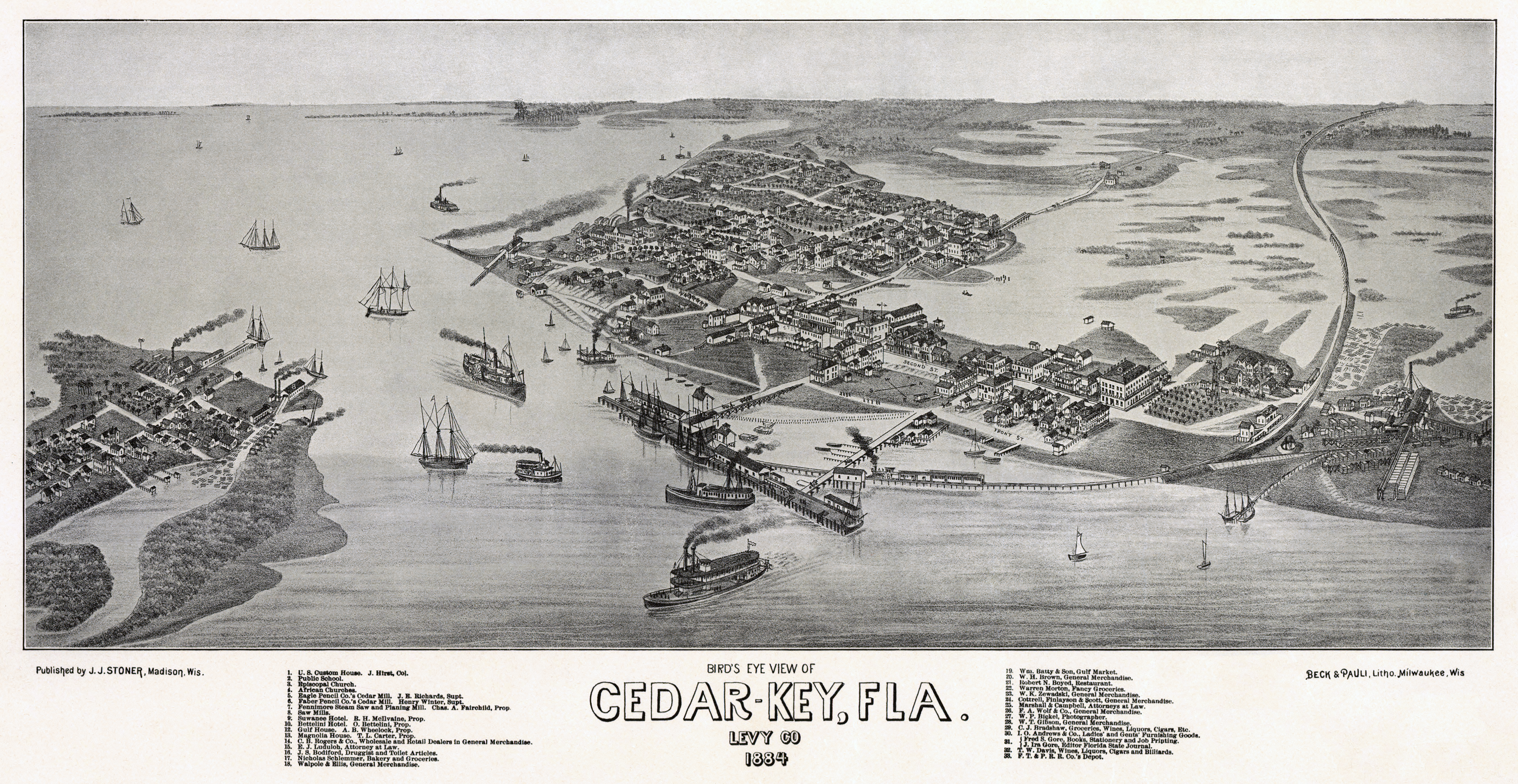
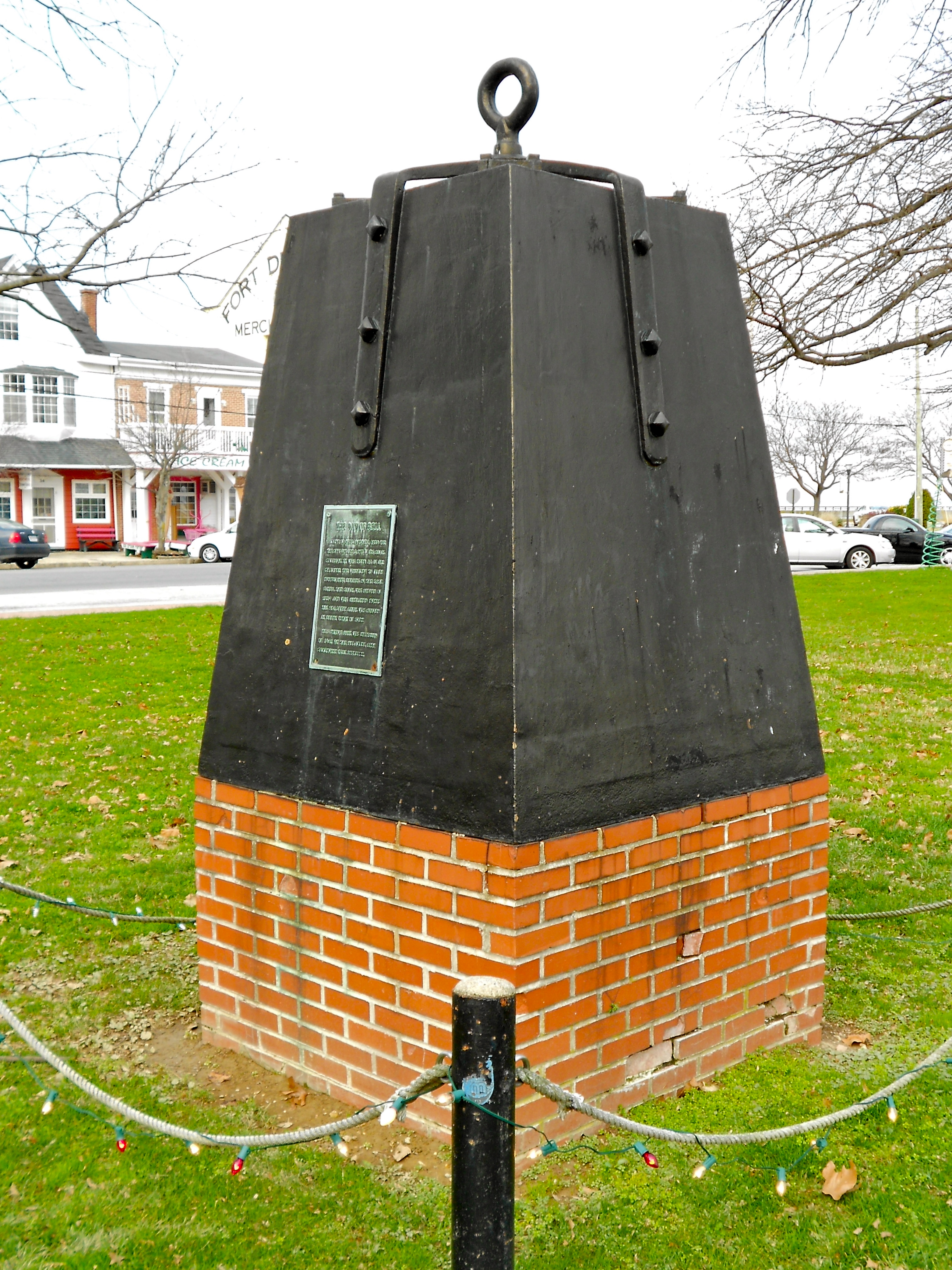
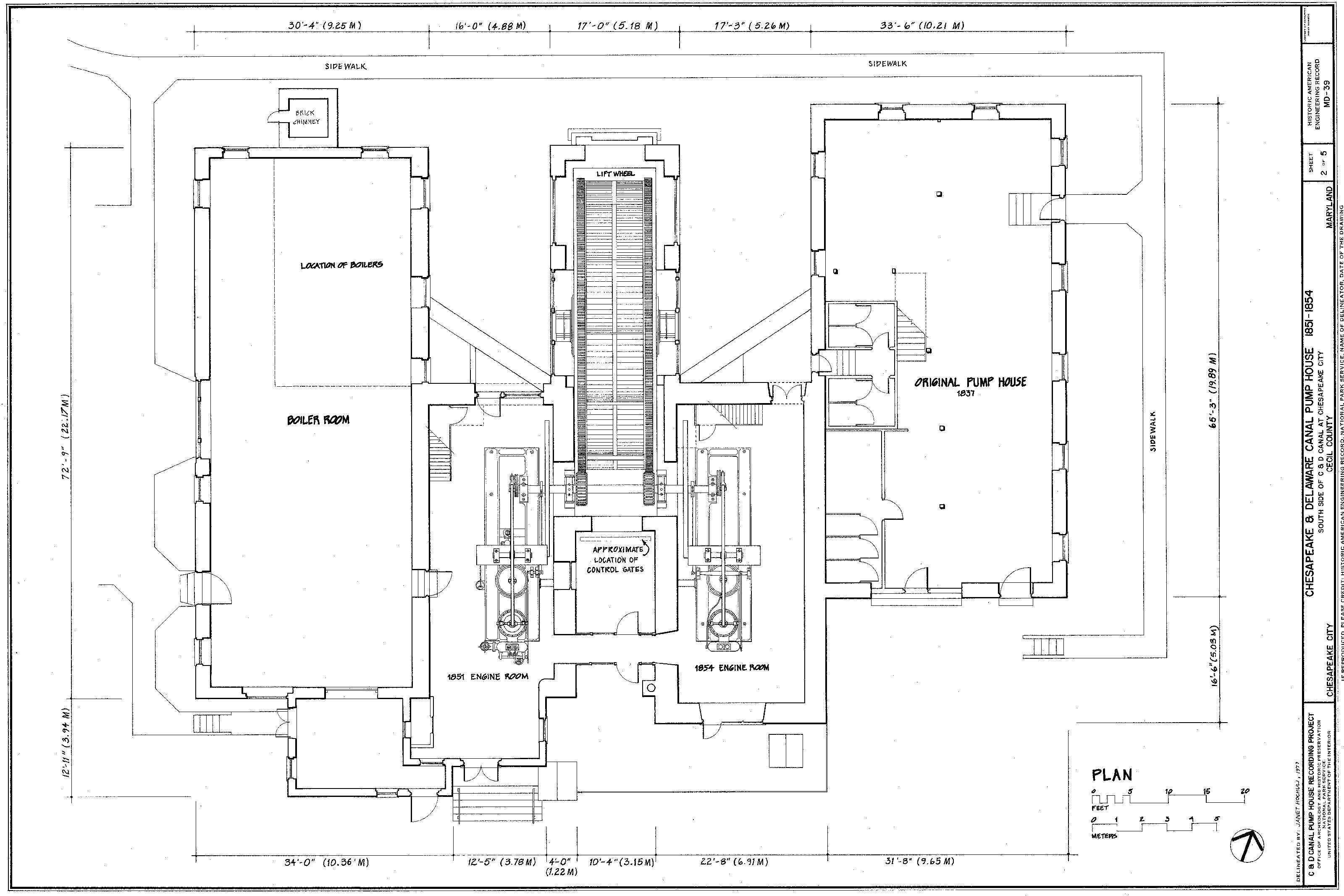
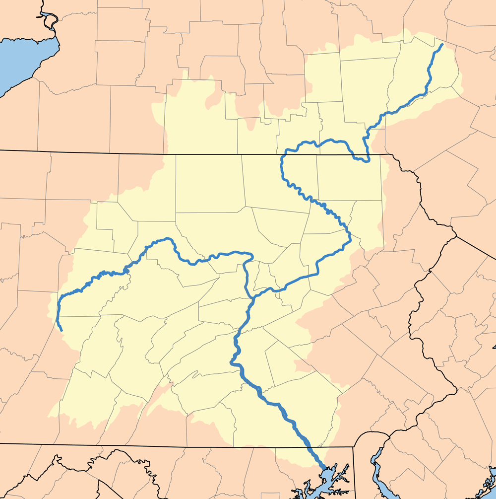
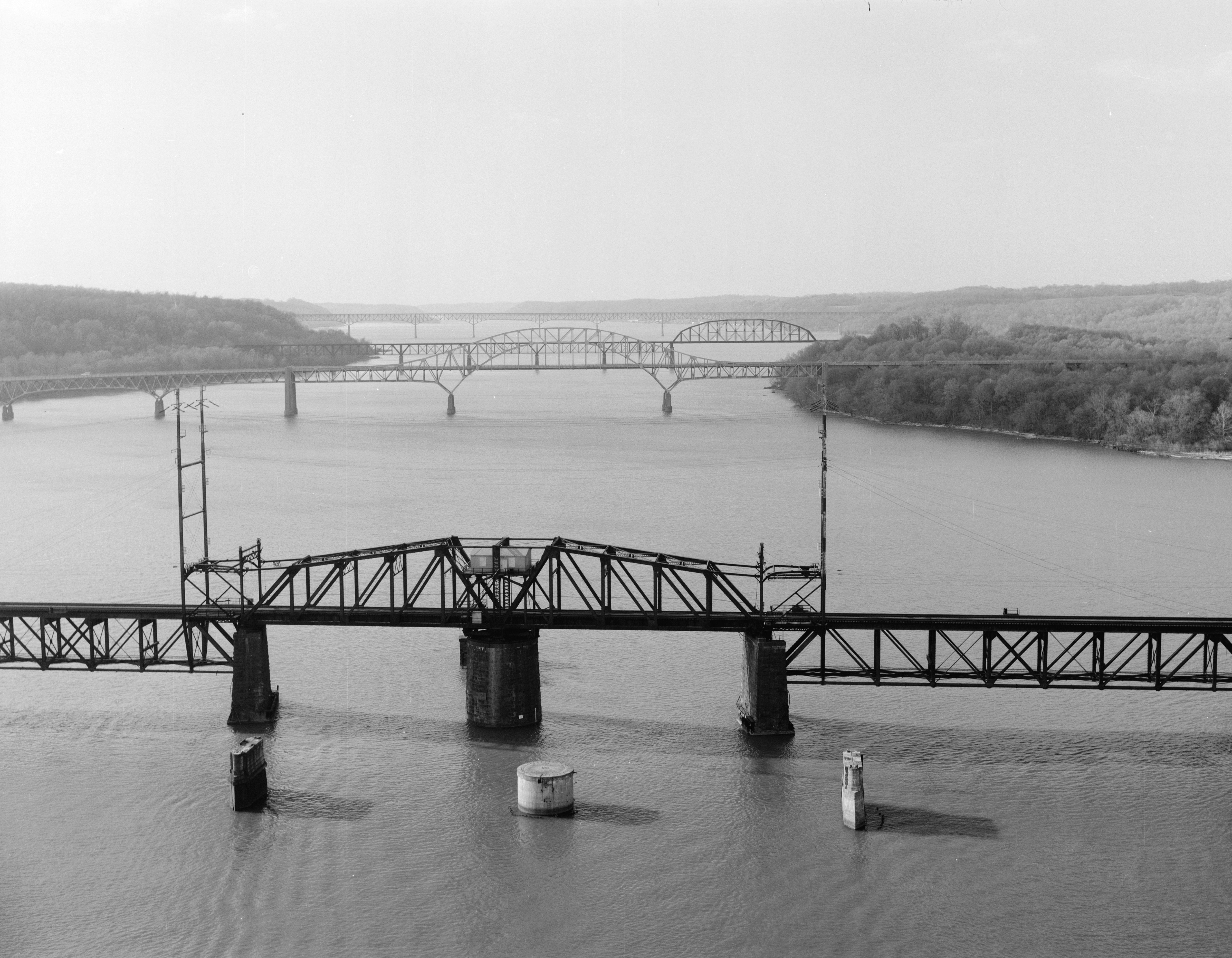
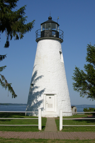