|
Reflections 2016
Series 10
June 20
East Coast I: Delaware River & Bay - Chesapeake Bay – Wilmington – New Castle
| | Central East Coast of the US On this trip, we're visiting the central part of the US East Coast, between the Delaware River and Charleston Harbor. We've already discussed in the recent past New York Harbor and the Hudson, as well as Cape Cod and New England, and even beyond, up into Nova Scotia and Newfoundland. We've also made reference to the area south of Charleston, into Georgia and Florida. Visiting, sometimes revisiting, areas in between are now appropriate. But it didn't start out being planned as such. | | | | About a year ago, I was looking for a closer destination here on the east coast, closer than on some recent trips, and Charleston came to mind. We'd been to Charleston in 1968 and 1988 (I had to look that up), but each time was a quick visit, just passing through. I felt now it was time to stay overnight and see a little extra. Savannah was an additional thought, but I felt I'd seen Savannah well enough (actually, in both those same two years). | | | | My first thought was a rail connection, round trip. While Amtrak's "Silver Service"--the Silver Star and Silver Meteor--are both overnight trains between New York and Florida, with the Silver Meteor serving Charleston (but before dawn), the Carolinian and Palmetto are day trains, the former servicing NC and the latter SC and GA. So the Palmetto it would be. | | | | And then came the head-slapping moment of realization. I was well aware, but had forgotten, that American Cruise Lines, whose coastal services I'd used in the past, has annual repositioning cruises for each of its three ships. In the spring, moving from winter service in the South to summer service in the North, each of its three ships has a one-off cruise from Charleston to Baltimore northbound, and in the fall, each one does the same thing southbound. So in May I could do a rail 'n' sail trip between the Northeast and Charleston. Super! | | | | There wasn't anything else I wanted to do at the southern end, and there would be plenty of coastal stops coming north, but there was more that really could be done—or redone—at the northern end in the Middle Atlantic area. That had blossomed with the trip on the Capitol Limited in late October 2014 (2015/1), when we talked train history in Baltimore and Ellicott City (which I'd never heard of before that). Then the train stop we made in Harpers Ferry was intriguing—years earlier we'd stopped there for a bit passing through, but neither of these experiences seemed enough now, just peering out from the train. We needed to stay here. And the whole Chesapeake & Ohio Canal! It ran between Cumberland MD and the Georgetown part of Washington DC. Also, Harpers Ferry Civil War history is closely tied with nearby Gettysburg PA and with even closer Antietam MD. And Gettysburg is just over the Pennsylvania border! It's been many years since we visited that battlefield, and after visiting Vicksburg, it seemed appropriate. The final addition was to visit the Chesapeake and Delaware Canal in DE/MD, the charming little attraction we'd visited almost by chance years ago. These thoughts became the core of the northern end of the trip. | | | | With all of this, the first part of this East Coast trip will center around the Delaware River & Bay and Chesapeake Bay, and thereby Delaware and Maryland. There will be reference to Pennsylvania only as its history was entangled with that of Delaware, although in discussing Maryland and the Potomac, we'll take a side trip off into the mountains which will include both Gettysburg PA and Harpers Ferry WV. | | | | The second part of this East Coast trip will connect the northern Chesapeake (MD & DC) to Charleston SC and back, and it will be a Charleston Rail 'n' Sail: Washington to Charleston by rail, then by ship back up to Baltimore, stopping in North Carolina and Virginia. At this point we'll be sticking to the coast and only discuss the coastal Carolinas and coastal Virginia, notably Virginia's southern end of the Chesapeake.
http://topnotchfla.com/wp-content/uploads/2015/01/east-coast-usa-map2.jpg
http://alumni.stanford.edu/content/images/travel-study/2011/maps/lg_map_intracoastal_2011_05.gif
| | | | If you have difficulty picturing the region just described, use the first map above of the entire US East Coast to guide you, southbound from DE to MD to DC, then later northbound from SC to NC to VA, and back to MD. Only with MD will we also go inland. The second map is related to the boat ride from Charleston to Baltimore, but it shows perfectly the five states we'll concentrate on, although Delaware is not named on this map. | | | | Geography It all starts with geography, going back prehistorically. The East Coast of the US exhibits drowned rivers to an extent hardly matched anywhere else. When the sea level was lower because of the buildup of polar ice, rivers flowed normally into the ocean. At the end of the last Ice Age about 10,000 years ago, the ice melted, the sea level rose, and the river mouths got flooded and drowned out. Let's start with two locations north of the general purview of this posting, but equally effected by drowned rivers.
http://woodshole.er.usgs.gov/pubs/of2006-1199/graphics/figures/fig1.gif
| | | | A large piece of Rhode Island is taken up by Narragansett Bay (above, disregard red areas). But what you're looking at is an estuary replacing three drowned ancient rivers. The mouth of the former Sakonnet River is now the Sakonnet Passage, and the mouths of the other two rivers are represented by the East Passage and West Passage. In addition, note that this estuary system is much larger than the minor rivers now flowing into it, including the Taunton, Providence, and Sekonk Rivers. | | | | Further down the coast in New York, we talked about the Hudson fjord in 2010/25. In sum, this is the route of the Hudson River (Map by Kmusser). But that's misleading. The river itself exists as a genuine river to about Poughkeepsie NY (po.KIP.si), which is about 2/3 the distance down from the Mohawk River. South of Poughkeepsie is the beginning of the Hudson Estuary (although no one calls it that—they still call it a river). The estuary (and the fantasy that it's still a river) continues to the New York City area (Map by Julius Schorzman), and includes the Hudson "River" (#1), Upper New York Bay (#2), and Lower New York Bay (#6), as well as all adjoining estuaries shown. One would think that that would be it, but the drowned Hudson continues under the sea. This is the Hudson Canyon on the continental shelf in the Atlantic. While the height is exaggerated for illustrative purposes, you see where the ancient Hudson Valley continued south, and is now more than thoroughly drowned out.
| | | | Delaware River & Chesapeake Bay Moving further down the coast, we come to the first two of our areas of concentration. We start with the Delaware River (Map by Shannon1), whose watershed we see here (click). The entire east bank is located in NY & NJ, which is of less importance for our purposes here. It's the west bank located in PA & DE which we'll concentrate on as we continue. But note that what once was the mouth of the Delaware River, at the ocean at the Delaware Capes (Cape Henlopen DE and Cape May NJ), is no longer considered that. Instead we have a drowned area of the river, the estuary called Delaware Bay. For that reason the Delaware is considered to "end" at the beginning of Delaware Bay, as though they were two different bodies of water. At least here, the name ties them together. (Note for another upcoming discussion that water in most of northern and central Delaware does flow eastward into the Delaware River & Bay.)
| | | | We will come back to the above topic, but let's move on to the much larger, and more spectacular in its history, Chesapeake Bay (Map by Kmusser), whose watershed this is (click). As we mentioned earlier, the northern part of the bay is in Maryland and the southern part in Virginia. But if you've been following our logic, you'll see a lot more than that, particularly the Susquehanna River to the north. It starts in New York, lies principally in Pennsylvania, with its southern tip in Maryland. Of course it's in Maryland—that's where the Chesapeake starts, and of course, the estuary known as the Chesapeake is the drowned southern part of the Susquehanna, though the two different names masks their relationship, unlike with the Delaware River & Bay. In ancient times the Susquehanna itself flowed down to the Virginia Capes, Cape Charles to the north and Cape Henry to the south. But today, the Virginia Capes are considered the entry to and exit from the Chesapeake, no longer the Susquehanna.
| | | | Take note of several other things on this map. As we saw Delaware waters moving eastward to the Delaware River & Bay, Maryland waters next to Delaware move westward to the Chesapeake. We'll see later how this point was significant to canal builders. Note to the west the border-forming Potomac, and also its northward-flowing tributary, the Shenandoah, which joins it at Harpers Ferry (not named here), which we'll be visiting. The other three Virginia rivers of importance N-S are the Rappahannock, York (unnamed), and James. The significance of mentioning these now is that each of them has its own estuary at its mouth and these are extensions of the Chesapeake estuary. Particularly notable—and visible on the map—is the substantial estuary of the Potomac. All these rivers had been tributaries of the primeval Susquehanna. Now they flow into the Bay, and their lower reaches share with the Bay the status of estuary. | | | | In case you had any doubts about this drowned river concept, this satellite image should convince you. Observe again what happened to the Delaware River to make its end into Delaware Bay, and to the Susquehanna to form the Chesapeake. In addition, all the rivers flowing into the Chesapeake show extensive drowning of their lower portions, most spectacularly the Potomac, whose huge estuary abutting the Bay identifies it on this view. Incidentally, the Chesapeake's name is of Algonquian origin, named after a village called Chesepiooc. This name describes the village as being "at a big river". I'll say. It's also particularly ironic, since the bay had been a river in ancient times. | | | | As we'll continue the trip south of the current regions, we'll also discuss the spectacular pair of estuaries in North Carolina that form the region of the Outer Banks, and in South Carolina, the smaller estuary of Charleston harbor, which had made the building of Fort Sumter necessary in the first place. But since we'll be traveling from south to north, the latter will come first. | | | | | | I've always been quite pleased with the historical summary we presented over five postings in 2009/21-25 entitled The Thirteen Colonies: 1600—1800, covering (north of Spanish Florida), from south to north, an area even larger than what we're visiting on this trip. We named therein four bays that are major Settlement Areas (Chesapeake, Delaware, New York, and the double Cape Cod/Massachusetts Bays) and discussed how they developed into provinces, then states.
As we now discuss (1) the Delaware River & Bay area, we find it was already described in the first part of 2009/23. As we discuss (2) the Chesapeake Bay area, that was already described in the latter part of 2009/21, and Virginia and Maryland in 2009/22. When we reach (3) the Carolinas, it will reflect on 2009/21. I do not wish to reinvent the wheel and tell those stories again. But I feel the need to refer to the principal interesting events involved. Please review the earlier postings if you are interested in more depth.
|
| | | | West Bank of the Delaware Now that we have the geography in place, we'll move on to a recap of the history of the arrival of European settlements. As for the Delaware River & Bay, there was no problem with the east bank, but from early on, there was a mixing of the fates of Pennsylvania and Delaware on the west bank. Let's look into that. | | | | The best map to help us with the Swedish and Dutch settlements is in Swedish Wikipedia, under the title Kolonin Nya Sverige 1638-1655 (Map by Arnapha & Tony92). The first word is "The Colony [of]" and the rest, pronounced NÜ.a SVÉR.i.ya. is New Sweden. But it also shows something earlier, the short-lived Dutch colony of Zwaanendael ("Swan Valley", the modern spelling would be -daal), built in 1631 and, after an altercation with Native Americans, gone by the next year. Take note of its exposed location, just barely inside Cape Henlopen, now the site of Lewes (LU.is), which has its ferry across to Cape May NJ. I've taken the ferry and visited the area, but there is little left to see. Still, Lewes proudly calls itself the First Town in the First State (Delaware was the first state to ratify the US Constitution, on 7 December 1787, resulting in that nickname.) | | | | The above dates for New Sweden show it was started later, in 1638, and survived longer. It was located out on the Bay, but well up into the River, on both sides. To this day, there is still a Swedesboro NJ. Since the Schuylkill River (sounds like "school" + "kill") is the centerpiece of Philadelphia today, it's obvious that Swedish settlements were there first. But the two locations of greatest significance coming down to us are both in Delaware: Fort Christina (1638), located on the Christina River in what is today Delaware's biggest city, Wilmington, and nearby Fort Casimir (1651), today's New Castle DE. But then, in 1655, New Sweden was conquered by the Dutch and incorporated into its colony of Nieuw Nederland (New Netherlands; Nieuw=NIÜ) (Map by Arnapha), located primarily in the Hudson Valley. | | | | | | We can mention three heritage items of from the Swedish and Dutch periods: (1) The influence of the Swedish flag on the flag of the City of Wilmington is obvious. (2) While we think of the log cabin as quintessentially American, eagerly pointing out that Lincoln was born in one, log cabins originated in Scandinavia, and historians believe they first reached the US via New Sweden. In Fort Christina Park in Wilmington there is, to commemorate this, a Swedish log cabin (Photo by Jerrye and Roy Klotz) in the style brought over from Sweden. (3) Once the Dutch took over this area, they referred to the Delaware River as the Zuydrivier (modern spelling zuid), or South River, a name that has now disappeared, in contrast to their alternate reference to the Hudson River as the Noortrivier (modern spelling noord), or North River, a term that is still used on occasion for the lower Hudson. |
| | | | But I find subsequent developments after the British became involved to be particularly intriguing. In 1664, just nine years after the Dutch took over New Sweden, they themselves were conquered by a fleet of English ships under the direction of James, the Duke of York, and that included all of the newly extended New Netherlands, both the South and North Rivers. This is where New Amsterdam became New York (as in "the Duke of"). But on the Delaware, things were more complicated. From the beginning, there was an unusual relationship between Pennsylvania and Delaware, and a conflicting claim to Delaware from Maryland. What a mess. | | | | Today, New Castle DE is a small (gorgeous!) town about a 20-minute drive SE of Wilmington, and almost acting as a suburb of Wilmington. Its importance is shown in that even the big city of Wilmington is in New Castle County. But it was in New Castle (ex-Fort Casimir) that took the lead from Fort Christina in importance, becoming the seat of government. Over time it had several other Swedish and Dutch names, but the British renamed it New Castle when they took over in 1664. We can consider New Castle the center of gravity on the west bank of the Delaware, well before the colonies of Pennsylvania or Delaware came about. | | | | Maryland had been chartered first on the nearby Chesapeake, which caused later problems (below). Here on the Delaware, it was now a matter of what lands went to the Duke of York and what went to William Penn. King Charles II had owed a significant debt to William Penn's father, and to satisfy it, in 1681, he handed over to William Penn a significant part of his American land holdings. The land included—note this—both present-day Pennsylvania and Delaware. It would seem that the entire west bank of the Delaware River might have been intended to be a single unit, just as NJ was on the east bank. But Charles created an exception. The Duke of York had won the Swedish and Dutch lands by conquest, and those were to be his. This is where Charles created the famous (infamous?) exception, the Twelve-Mile Circle (19 km) out of New Castle. This circle of land, extending down to Cape Henlopen, the Delaware Cape on the west bank, was to go to the Duke of York, the rest to Penn. | | | | | | The center point of this circle was interpreted to be the spire on top of the building that was Delaware's Colonial Capitol, then the first State House. When we last mentioned this circle in 2016/8, it was to point out the three tiny exclaves of DE in NJ that it caused, as well as the fact that the entire width of the river within the circle belongs to DE. But now we'll emphasize its most striking affect, that it traced the distinctive arc denoting the northern border of Delaware with Pennsylvania. While such rounded borders are highly unusual, they are not unique. Refer back to the posting on enclaves and look again at the border of the Vatican, part of which is formed by the rounded colonnade around the Piazza San Pietro.
http://www.landsat.com/town-aerial-map/georgia/map/plains-ga-1361628.jpg
Another example is shown in the above map of Plains GA, the home of President Jimmy Carter. The town has a circular border, plus a small panhandle.
|
| | | | Despite the restriction on the grant Charles gave him, Penn in the beginning seemed to work it out to his satisfaction to have an outlet to the sea for Pennsylvania. He'd persuaded James, the Duke of York, to lease him his property. So when he set sail for America, he arrived with two documents, a charter from Charles for the Province of Pennsylvania and a lease from James for what became known as the Lower Counties on the Delaware. With these documents, he took his first step on American soil in New Castle in 1682. On the current trip I saw the historic marker commemorating his landing, once again, not in today's Pennsylvania but in Delaware. Penn established his government in New Castle, and then journeyed upriver to found Philadelphia. | | | | Penn always tried to keep the two territories together. He established a combined assembly, and required that legislation have the assent of both the (then) five Upper Counties of Pennsylvania and the three Lower Counties of Delaware (which still exist today). The assembly alternated meeting between Philadelphia and New Castle. But Penn's Quaker government was not viewed favorably by the Swedes, Dutch, and English in Delaware, and they began to petition for their own assembly. Also, Philadelphians resented having to go to New Castle to gain assent from the sparsely populated Lower Counties. | | | | Finally, in 1704, the two regions agreed to pass laws separately and the colonies split, although Penn and his heirs always appointed the same person Governor of the two. However, this is not unique. From 1703 to 1738, NY and NJ shared a governor, and for a time, so did MA and NH. But in the long run, despite Maryland's competing claims, which we'll get to shortly, PA and DE became two colonies and two states, and Charles II's unique Twelve-Mile Circle continues to this day to be the border between them. | | | | Delaware Just a word or two on Delaware's size and name. Delaware, going back to its Pennsylvania days, has always consisted of just three counties, New Castle, showing the historic importance of that town, Kent, and Sussex. The capital was moved in 1777 from New Castle to the more centrally-located Dover, a city that had been founded by William Penn (!!) in 1683 and named for Dover in England.
| | | | Delaware is the second smallest state in the US, yet its three counties are the lowest number of counties of any state. The smallest state is famously Rhode Island (Map by Ajlarson29), which is almost exactly the same size as Delaware's Sussex County. Yet even RI has five counties, which, however, started out as one, which was subdivided. To compare the two states in size, Delaware has 160% of the total land area of RI; conversely, RI has 62% of the total land area of DE. | | | | Delaware was named after the river, which was named after Thomas West, 3rd Baron De La Warr, who was governor of the Colony of Virginia at the time the river was first explored by Europeans. The locally indigenous Lenape Indians were called the Delaware Indians because of the river. | | | | To continue this discussion, I have to mention a language fact. Initial GW- is a combination of sounds going back to Indo-European that has come down in various ways. It exists in English, but mostly with proper names (Gwen; Button Gwinnett, whose signature on the Declaration of Independence is the rarest of all). But most interesting is what happens in related words. GW is fully maintained in Italian guerra (pronounced with GW), but the W is lost in Spanish guerra and French guerre, both of which maintain a historic U in the spelling, but which is not pronounced. On the other hand, the corresponding English word, war, has maintained the W—actually spelled W--but lost the initial G. This phenomenon can also be illustrated just within English, which has some curious pairs: guard/ward; guardian/warden; guarantee/warranty. While this first pair, curiously, has opposite meanings, the other pairs are similar in meaning, yet illustrate the G(U) versus W phenomenon, with the U never being pronounced. | | | | That leads into something new I have now learned. The surname De La Warr is of Norman origin, brought to Britain from France after the Norman Invasion in 1066 (2012/16). It turns out the name is the Norman French version corresponding to what in Standard French would be De La Guerre. So we can now say that the last syllable of "Delaware" is related to the word "war"!
http://www.worldatlas.com/webimage/countrys/namerica/usstates/lgcolor/delmarva.jpg
| | | | Delmarva Peninsula As we move to the Chesapeake, we cross the Delmarva Peninsula. The map above shows with particular clarity that the peninsula consists of most of Delaware (DEL), the Eastern Shore of Maryland (MAR) and the Cape Charles exclave of Virginia (VA), hence the frankensteined name. The two bays we're discussing set the peninsula off from the rest of the mainland, and, in addition to the narrow neck (or isthmus) where it's attached, the peninsula is connected only by the already-mentioned ferry at the Delaware Capes (not shown here), the massive Chesapeake Bay Bridge Tunnel at the Virginia Capes, and the Chesapeake Bay Bridge in the Annapolis area. Drivers between the NE and SE who wish to avoid the speedy, but hectic, NE Corridor route of I-95 through Baltimore and Washington can use the Delmarva route, either going via the neck and bridge tunnel or, even more pleasantly, via the ferry at the Delaware Capes and bridge tunnel at the Virginia Capes. I've used at different times, the ferry and both bridges, but on the current trip we'll enter and exit at the neck to visit just the northernmost section of the Peninsula. Later, on the cruise, we'll also make a stop to visit St Michael's on Maryland's Eastern Shore (not shown here). | | | | The Atlantic Coastal Plain (Map by Kelvinsong) is flat and sandy, with very few to no hills, and the Delmarva Peninsula falls entirely within that area. Click to inspect that, and further note how the contiguous part of the plain runs from NJ to FL. But also note that, separate from this, the plain covers Cape Cod & Islands as well as Long Island, an area known as the Outer Lands, which we discussed in detail in 2010/26 (if this term is unfamiliar, I suggest you take a look). | | | | Having a coastal plain implies that the land gets higher further inland, which is exactly the case. This is the Piedmont Plateau (Map by Kmusser), stretching from NJ to AL. It's named after the Italian Piedmont in the foothills of the Alps, adjoining France. Merely a close inspection of the name yields "foot" (think "pedal, pedestrian") and mountain, so a Piedmont area consists of the foot[hills of the] mountains. And this logically brings us one step further, to the Appalachian Mountains (Map by Greatvalley-map.jpg: Pfly). This map totally summarizes the Coastal Plain in white, the Piedmont in green, and then the mountains. We point this out now, since, while most of this trip is coastal, we'll go inland up the Potomac to the region around Harpers Ferry, one of whose main features is a spectacular water gap in the Blue Ridge Mountains. We'll also take a few steps on the Appalachian Trail in Harpers Ferry. As also mentioned, the Shenandoah River (#8 is the Shenandoah Valley) joins the Potomac there. | | | | But let's come down from the Blue Ridge to make one last point, more apropos of the coast. From the Piedmont Plateau to the Atlantic Coastal Plain, there is, by definition, a drop in altitude. The line where this happens is called the Atlantic Seaboard Fall Line, which is an escarpment (ancient shoreline) along what is essentially the upper (exposed) continental shelf. We will later visit the Great Falls of the Potomac, west of Washington. These falls exist because the Potomac drops from the Piedmont Plateau at the fall line, to the Coastal Plain (find it on the map, based on the Potomac's large estuary). This escarpment for a long while (until locks were built) formed the head of navigation of rivers along its route. Also, since rivers coming down over the fall line provided power for commercial use, many cities were founded along the fall line, Wilmington among them. US 1 is a route that essentially runs along the fall line, connecting these cities. I suppose it also can be said that I-95 is roughly where it is for the same reason, as well as the entire Northeast Corridor, for rail and road.
http://www.ezilon.com/maps/images/usa/delaware-physical-map.gif
| | | | I've come across a series of very nice physical maps for our five principal states, DE, MD, then SC, NC, VA, with the MD map showing adjacent areas of PA and WV. The only quirk of these maps is that they're all consistently tilted to the left, as above. Your guess as to the cartographer's purpose in doing this is as good as mine. Still, it shows that Delaware is all on the coastal plain, that Dover, the capital, is the second city, and that Wilmington abuts the Philadelphia agglomeration. In addition, almost all the curved area is in the Piedmont, with the fall line running diagonally SW of Wilmington, showing that this is the part of DE not on the Delmarva Peninsula. However, do note the (here unnamed) Chesapeake & Delaware Canal a little further south cutting through Delaware City (here misplaced—it's on the river). Since the canal, which will be our first stopping point, is so visible, for practical purposes people tend to consider it the northern border of Delmarva. | | | | Chesapeake Bay With the Delaware River and Bay, we found only the west shore a point of interest. Now, with Chesapeake Bay, we'll discuss both shores as a single unit, as the Bay is divided between Virginia in the south and Maryland in the north. But let's start by going back to the original concept of settling this area to be known as "Virginia".
| | | | In 1583, British settlement of what became the East Coast of the US began with Queen Elizabeth I of England granted Walter Raleigh a charter to start a colony north of Spanish Florida. In 1584, Raleigh sent the first expedition to that coast. The name "Virginia" may have been proposed at that time either by Raleigh or Elizabeth, in reference to her status as the "Virgin Queen". The name "Virginia" first appeared on a map in 1587; it's the feminine form of Latin Virginius. The name initially applied to a huge coastal region, well beyond today's Virginia, and also included Bermuda. | | | | The very first time English colonists arrived in the region of the Virginia Capes was not quite at that location, but a bit further south, although nevertheless under the jurisdiction of the Virginia Company. They arrived in 1584 to found the "Lost Colony" on Roanoke Island in today's North Carolina, which we'll discuss when we're there. They were under the direction of Sir Walter Raleigh, although he himself went to South America and never set foot in North America. While Roanoke was the birthplace of Virginia Dare, the first English child born in the Americas, because the colony disappeared, history only mentions it in passing. | | | | It was in 1607 when colonists actually entered the Chesapeake under Captain John Smith and made, on Cape Henry, the southern cape, what is now called the "First Landing". Let's see how Smith saw the area around Chesapeake Bay in this 1630 version of the 1612 map he drew up during his exploration of the area. Don't be misled. This is another of those maps lying on its side, with north to the right. But this is one case where that makes some sense, since they were headed west from Europe and this map, looking west, is how they approached North America. Click to enlarge, and inspect the Virginia Capes at the entrance of the Chesapeake, Cape Henry where the initial landing was made and Cape Charles on the Delmarva. (Smith went overboard on illustrating the "mountains" of Delmarva, since, as we know, it's a coastal plain.) | | | | This landing at Cape Henry initiated between 1640 and 1675 what was a mass migration to the Chesapeake Bay region to the new colonies of the Province of Virginia in the south bay and Province of Maryland in the north bay. An advantage of Smith's map above is to be able to see how Virginia colonists, instead of hanging a right up the bay, went straight ahead from the Capes up what they named the James River to found Jamestown. Sail up the river as they did and you'll actually find it—this is the fun of old maps. But careful—here it's ſpelled Iameſtowne. Another bit of fun is to find how many times Long S (ſ) is uſed, medially, ſometimes initially, but never finally, on the "Cheſapeack" map (ſee 2011/22). | | | | Virginia We'll limit ourselves to just talking about the coastal and bay area, known as Tidewater Virginia, a bit now, a bit more when we get there. But we had a nice set of colonial maps in the 2009 series of articles, and I want to repeat the appropriate ones here, in just a moment. | | | | | | I'm going to wave my "Virginia flag" one more time. In 2009 we described four settlement areas (the Carolinas were essentially Virginia outposts). Jamestown in the Chesapeake was the first permanent English settlement in the Americas in 1607. The so-called "Pilgrims" (I disavow that term) were in Cape Cod Bay in 1620. The Dutch were on the Hudson in 1624. The Swedes were on the Delaware in 1638. It's obvious that the English were the Europeans who won the race, but I do not understand why the Plymouth Colony in Massachusetts, which harbored secondary arrivals, is celebrated to the extent that it is, including that Thanksgiving business. Ask the man on the street about European arrival in the US and he's sure to refer to MA and not to VA. And on top of it, the "Pilgrims" were on their way to VA when they were forced by the weather to stop in MA; they later made a second, unsuccessful, attempt to reach VA, but had to turn back. Why isn't Jamestown given its due credit and celebrated more than it is? |
| | | | As to our colonial maps, we'll start with the Colony of Virginia (Map by Kmusser). Look at the importance of VA back in time. Look at the two red lines covered by the original charter and you'll see the connection to the Carolinas and to claims to the Northwest Territories. Check out how Bermuda was administered by VA. (Also note, for reference, that Delaware is shown as an appendage to Pennsylvania.) But mostly it comes down to the white area, where VA borders a bit of the Mississippi, at least until Kentucky broke away in 1792, with VA's consent. The Civil War caused VA to lose a large part of its territory when West Virginia in 1861, instead of voting to secede from the Union with the rest of VA, instead voted to secede from VA itself, against the will of VA; statehood became finalized in 1863. With that split, about 1/3 of the prewar territory went to WV and 2/3 stayed with VA (36% to 64%).
http://www.ezilon.com/maps/images/usa/virginia-physical-map.gif
| | | | But let's look at VA today, the remaining 2/3 of it, in this version again tilted to the left. To the west are the Appalachian Mountains, then comes the Piedmont Plateau, with the fall line running roughly through Richmond, and finally we're down to the Atlantic Coastal Plain, or Tidewater Virginia (Map by Ali Zifan), shown more precisely in this view. By definition, any part of VA affected by the Atlantic or Chesapeake tides fits this name, although in practice, the Eastern Shore exclave of Cape Charles on the Delmarva, being more isolated despite the Bridge-Tunnel, can often be excluded. Doing so leaves us, on the Western Shore, with four rivers forming three peninsulas, plus the large urbanized area at the south end of the Chesapeake, so let's look more closely at these areas (click):
http://www.accessiblevirginia.org/maps/images/tidewatermap.gif
| | | | The Potomac forms the border with Maryland. Between its wide estuary and the Rappahannock lies the peninsula known as the Northern Neck. I particularly remember when visiting this area the George Washington Birthplace National Monument and Stratford Hall, the plantation house of four generations of the Lees of Virginia. It was the boyhood home of two Lees that signed the Declaration of Independence and the birthplace of Robert E Lee, the Confederate General. | | | | Between there and the York River lies the modest Middle Peninsula, known for its quiet rural life. But what it lacks in pizzazz is made up by the Virginia Peninsula between the York and James Rivers. As the name implies, the Virginia Peninsula is the historic heart of the state. Shown is Williamsburg, site of the fabulous restoration known as Colonial Williamsburg. On the tiny peninsula to its south in the James River is its abandoned predecessor, Jamestown (not named here), and down the York River is Yorktown, where Washington defeated Cornwallis in 1781, effectively ending the Revolutionary War. These three sites form the Historic Triangle, which we'll refer back to again when we're in Virginia later. | | | | The end of the Virginia Peninsula includes the cities of Hampton and Newport News (see map) and across the waterway known as Hampton Roads continues the urban area also known as Hampton Roads. This includes Norfolk with its naval tradition, and Virginia Beach, which includes today Cape Henry, the site of the "First Landing". | | | | Maryland While settlers headed for the Colony of Virginia went straight into the James River after entering the Virginia Capes, those headed for the Colony of Maryland hung a right and went north into Chesapeake Bay. George Calvert, 1st Lord Baltimore, had tried to get a charter from Charles I for the territory between Virginia and Pennsylvania, but died before it was issued, so it instead was issued to his son Cecil Calvert, 2nd Lord Baltimore, in 1632. | | | | | | This was not George Calvert's first attempt at colonization in North America. As we reported in 2013/12 in Newfoundland, he founded a settlement called the Colony of Avalon. Although it failed, it gave its name to the Avalon Peninsula, the principal population center of Newfoundland on the SE coast, which includes the capital of St John's. |
| | | | Maryland was named for the wife of Charles I, Henrietta Maria of France, who was also mother of Charles II and James II. Over time, the name "Maryland" has been considerably altered, so that today it's pronounced MER.i.lind. This is its (tilted) map:
http://www.ezilon.com/maps/images/usa/maryland-physical-map.gif
| | | | The first settlers of Maryland sent by Lord Baltimore arrived in 1634. Contrary to what one may imagine, they settled almost as far south as possible within the West Shore confines of the Colony, founding St Mary's City on the Potomac. On the above map, find Point Lookout on the Potomac estuary; St Mary's City is in the first bay upstream. It was the first capital of Maryland and remained so for 60 years. While crops were profitable, life expectancy was shortened by the presence of extensive malaria and typhoid, and in 1695, the capital was moved to the more central Annapolis, still on the Chesapeake (see map). With the seat of government gone, the town declined to an agricultural area, even its center being converted for farming use. Today, the former colonial town is a state-run reconstruction called Historic St Mary's City. I've visited it in the past—the region is today a quiet backwater. | | | | The map shows how the whole center of gravity of Maryland is on the upper Western Shore; not only Annapolis, but Baltimore and Washington are there—keep in mind that the District of Columbia is located on land donated by Maryland. Actually, the fall line connects Wilmington, Baltimore, and Washington. The (Chesapeake) Eastern Shore of Maryland has remained over the centuries a charming quiet collection of small, historic towns, the goal of visitors, not only from the Western Shore, but from everywhere. For future reference, St Michaels, not named here, but which we'll visit later, is on the south shore of Eastern Bay. | | | | | | As we described in 2014/20 when in Nova Scotia, Annapolis MD, which had had another name, was renamed in honor of Queen Anne by the Royal Governor of Maryland, Sir Francis Nicholson, when the capitol was moved here. Later, as Colonel Francis Nicholson, he led the force that took over Port Royal in Nova Scotia, and in 1710 he renamed that town Annapolis Royal, once again for Queen Anne. But the Maryland city has had the name longer, by fifteen years. I found it a small, compact, historic capital city, which has housed the US Naval Academy since 1845.
While we're talking about name origins, we can mention the obvious, that Baltimore was named for Cecil Calvert, 2nd Lord Baltimore. His title stemmed from the small port town of Baltimore in southwestern Ireland, in County Cork, where the family had its seat. As is so often the case in Ireland, the word "Baltimore" is an anglicization of the Irish Baile na Tighe Mor, or "town of the big house".
That is as far as most explanations go, but I dug deeper. While the above is indeed the Irish version of the name, the actual Irish-language name for Baltimore (in Cork), is entirely different, being named after O'Driscoll castle: Dún na Séad, or "fort of the jewels". Furthermore, whereas in Maryland, Bal- rhymes with "ball", in Cork Bal- rhymes with "pal".
|
| | | | Maryland has to be the oddest-shaped state of all—it seems to run off in all directions from its center of gravity on the upper Western Shore, and the reasons for this are simple. Maryland was squeezed top and bottom like batter in a waffle iron. Where else could it spread out but sideways? | | | | The bottom was not the problem. Maryland's charter of 1632 placing it north of Virginia in the Chesapeake area very clearly defined the border as the Potomac River (Map by Kmusser), as this map of its watershed from its huge, drowned estuary, up past the Great Falls on the fall line, back into the mountains, indicates. We can make several other points here. ● Of the two upper branches of the young Potomac, it was made clear from early on that the North Branch was the border, and was so indicated by a marker called the Fairfax Stone in 1746 (see map). ● From the Fairfax Stone due north is also the line that marks Maryland's western border. It's odd that most straight-line borders are either N-S or E-W, with very few at an angle, even if an angular line would have avoided the problems at Point Roberts and the Northwest Angle (2016/8). ● Curiously, the charter gave the whole width of the river to Maryland, although with navigation rights to Virginia. We saw that happen first with NJ originally not having any of the Hudson until that was adjusted (see 2016/8 "Ellis Island"); with NJ not having a central piece of the Delaware because of the Twelve-Mile Circle (ditto, "Twelve-Mile Circle"); and now with Virginia not having any of the Potomac whatsoever, other than the South Branch at the upper end. When you stand on the south bank of the Potomac, you dip your toe into Maryland waters (or DC waters, since DC was taken from MD). ● For future reference note that, if the C&O Canal, built along the north bank of the Potomac, had ever been built beyond Cumberland MD on its original route to Pittsburgh, after Cumberland it would have left the side of the Potomac in any case. | | | | | | For the sake of completeness, we should add that the MD/VA border in the Delmarva starts in the drowned Pokomoke Sound (see MD map) and follows the corresponding Pocomoke River up to straight line to the Atlantic, including dividing Assateague Island, known for its wild horses. |
| | | | It was not VA at the bottom, but the top of the waffle iron that squeezed Maryland into its long shape, and to me the most interesting news about the development of Maryland is the conflict we only hinted at earlier. We said that the Duke of York made his conquests in 1664 and William Penn got his charter in 1681. But Cecil Calvert (Lord Baltimore) got his charter for Maryland much earlier, in 1632, and had serious claims for much of the same, overlapping territory. | | | | Maryland's charter had granted the Calverts land north of the Potomac, as we've seen, and up to the 40th parallel. But when Charles II later granted a charter for Pennsylvania, although its southern border was carefully defined as identical to Maryland's northern border, an inaccurate map was used, indicating that Charles II and Penn thought the 40th parallel would fall at around New Castle DE, whereas in actuality, it falls in what would today be the northern part of downtown Philadelphia, and would even have included within Maryland where Philadelphia's City Hall is today. | | | | In addition, the eastern boundary was Delaware Bay and the Atlantic, so the intent was apparently to give Calvert all of the northern Delmarva above the bit going to Virginia (that would then have excluded what is now Delaware—would that have made it just Marva?). But there was a caveat: the Calverts had the rights only to "uncultivated" lands, which presumably means lands not previously settled, so the Swedish-cum-Dutch settlement area on the Delaware was already a thorn in the Calverts' side. To make things worse, the Calverts made little to no attempt in surveying the northern border or colonizing along Delaware Bay. | | | | Complicating the matter even further was the fact that the Duke of York leased the Twelve-Mile Circle down to Cape Henlopen to Penn in 1682, and worse still, that that lease was of dubious legality, since York himself didn't get the charter to these lands until the next year, 1683. Then politics and appeasing royal sensibilities came into play. Calvert didn't press his claim early on in deference to the royal will of Charles II to please his brother, James, the Duke of York, who in turn, believed he'd won the area in war and was justified in ownership. What a mess. | | | | Penn and Calvert met in New Castle, but found no solution. Penn argued the familiar point, that the Maryland charter gave Calvert only unsettled lands, and that the Swedish/Dutch settlement on the Delaware predated his charter. In actuality, Penn strongly wanted Pennsylvania to have the west bank of the Delaware down to Cape Henlopen to give it access to the sea. Calvert felt Maryland should have all the northern part of Delmarva, to say nothing of a northern Maryland border that was well further north. It was the beginning of a long legal dispute lasting eight decades, carried out by the descendants of the Calverts and Penns. A final agreement wasn't signed until 1760, based on two lines of significance. | | | | The Transpeninsular Line was the first line decided on, back in 1751, and cut straight across the Delmarva from Bay to Ocean. But it was another instance of the Calverts shooting themselves in the foot. It would seem that the Calverts had finally yielded to the fact that they wouldn't have the whole upper part of Delmarva for Maryland, but had to yield to Penn a strip of land along the Delaware down to Cape Henlopen. But the problem was that there was, once again, a map in error, and worse, that the map had been commissioned by Charles Calvert himself back in 1732, Charles now being the 5th Lord Baltimore. | | | | This is where the mistaken, but valid, Transpeninsular Line was drawn. While the Calverts were willing to give to Penn (and Delaware) the shoreline down to the Lewes area, where Cape Henlopen actually is—picture on the map where that would fall--the map in error showed the cape much further south, at what is actually Fenwick Island. Calvert discovered the error only after the map he himself had commissioned had been submitted to the English court deciding the case, but could do nothing. Thus, Delaware today, whose very name implies a location just the river and bay, actually has a considerable shoreline along the Atlantic, totally because of this mistake. And to boot, this shoreline includes the modern, very popular, resort area of Rehoboth Beach DE, which would otherwise have been in Maryland. | | | | If the actual Cape Henlopen had been used to draw the line, Delaware would be about 2/3 of the small size it already is. Also note that the midpoint of the Transpeninsular line was used to draw an additional, perpendicular border, which is today Delaware's western border with Maryland. Thus, Delaware ended up with a considerable chunk of what would have been Maryland's exclusive Upper Delmarva, and Maryland wraps around it (see MD map) in order to reach the abbreviated Atlantic coastline remaining to it. But then, Ocean City MD is a major resort today, too. | | | | That's how Maryland, in its dispute with the Penns, got squeezed at its eastern end. But its western end didn't fare much better, actually quite worse, resulting in Maryland's famous, odd panhandle. How could a state be squeezed into such tiny strip? Look at this map of the colonial Province of Maryland (Map by Karl Musser), which shows definitively how Maryland was squeezed into its odd present shape between Virginia and Pennsylvania (with Delaware), although none of the fault was Virginia's (also note St Mary's City). First note how PA-DE are shown here as a single unit, not de jure, but de facto in this period. Note how DE takes the huge chunk out of MD on the Delmarva. I would disregard Pennsylvania's southern claim, since that seems to me just a bargaining chip during negotiations, but do note Maryland's valid claim up to the 40th parallel that would have included most of Philadelphia in MD, and also Gettysburg, by the way (see MD map). | | | | If the line had ended up further north, MD would still have had a long panhandle, but wider. It's good the line didn't end up falling further south, at or even beyond the Potomac, because then MD would have been split in two with a western exclave. As it is, the panhandle is narrow, but nowhere narrower than at Hancock, not named on MD map, but which can be found on the map where I-70 crosses into PA. This is the "wasp waist" of MD. The width of MD between WV and PA at Hancock is only 2.9 km (1.8 mi). Of course, we'll go out of our way to drive that distance, and it will take us about three minutes to cross MD. Nevertheless, through this wasp waist, along Maryland's Potomac River runs the C&O Canal, the B&O railroad (we were on the Capitol Limited through there—see 2015/1) and a combined US-40 & I-70/68. Not bad for a wasp waist. | | | | But the 1760 agreement between the Calverts and Penns accepted the Transpeninsular Line of 1751 and set the rest of the modern border between MD and PA/DE. But to seal the deal, as we've already noted on these last two maps, the surveying team of Charles Mason and Jeremiah Dixon was hired to set the agreement in stone along what was since known as the Mason-Dixon Line (MDL). And that is meant literally. Starting three years after the agreement, the two hiked, between 1763 and 1767, almost the entire length of that L-shaped border to set periodic stone markers along the route of the Mason-Dixon Line (no attribution), now famous in US history. | | | | | | Considering simple geometry, it will be realized that a right angle and a circle abutting each other will not blend well, and leave spaces. That's the reason for the existence of the Delaware Wedge (Map by Exterioramoeba), shown here in red. It remained disputed territory until 1921, when it was finally granted to DE, and appears today as a small "shoulder" on the Twelve-Mile Circle. PA had claimed the Wedge because it was beyond the Twelve-Mile Circle and therefore not in DE, and also past the MD side of the MDL, so not in MD. DE claimed the Wedge because it was never intended for PA to go below the northern border of MD. DE won. This topographic map by the 1898 US Geological Survey shows the Wedge in yellow as still being part of PA. The tiny community (click) within the Wedge then known as Mechanicsville PA later became Mechanicsville DE. |
| | | | There are numerous interesting points that can be made here. ● Contrary to what I'm sure is common belief, the MDL is not a straight line, but L-shaped. ● The MDL remains to this day all or part of the borders between MD/DE, MD/PA, and PA/WV (WV was then still part of VA). ● As to its eastern end, I find it unusual that the Transpeninsular Line was not made part of the MDL. ● As to its western end, it's an interesting reflection of the period that Mason and Dixon were prevented from finishing the western portion of the line (see map) due to the danger of a potential conflict with American Indians. It was later extended by others. ● The MDL is surely the most famous interstate borderline in the US. It seems to me extremely odd that it was named after a pair of employees who were just carrying out the terms of the Calvert-Penn agreement. Why isn't it called the Calvert-Penn Line? Wouldn't that have been much more logical? ● I now discover that the frequent use of the word "line" to mean "border" is a quirk of American English. Others may talk of borders or frontiers. American English uses "border" primarily for international use, such as "the Canadian border" or "the border between France and Italy". For domestic use, almost always, borders are called "lines", which is really quite quaint. We almost always talk of state lines, county lines, and city lines (also "city limits") instead of state, county, or city borders. We also do NOT say "Transpeninsular Border" or "Mason-Dixon Border". Curious. | | | | But the last oddity requires a paragraph by itself. There is the REAL Mason-Dixon Line and also the mythic Mason-Dixon Line. And the difference once again, is Delaware. We see the existence of the mythic MDL in the common conception that the MDL is not L-shaped, but straight across the bottom of Pennsylvania, thereby also including the Twelve-Mile Circle and placing Delaware on the other side of the line. Why should this alternate exist? Actually, it's the reason the MDL is famous: slavery. | | | | As this map shows (Map by Golbez), by the early 19C, states from Pennsylvania north had abolished slavery, and those south of it had not. For that reason it became convenient to refer to the Pennsylvania border as the dividing line, and so the mythic MDL developed, putting slave-holding Delaware to the south of the "border", despite what the actual MDL indicated. This mythic line not only extended to the east around the Twelve-Mile Circle, it also figuratively extended west along the Ohio River (see 2016/3, Eliza flees across the Ohio) and partially up the Mississippi to separate Missouri and Illinois (ditto, "Dred Scott"). Thus the actual MDL is little known, while the vastly extended mythic MDL is historically the dividing line between The North and The South in US history. | | | | But since the mythic MDL wasn't a real line, the result was as shown in this map of the most unusual situation during the US Civil War known as the Border States (no attribution). All the states in pink ("The South", de facto) declared they were seceding from the Union, shown by the states in dark blue ("The North", de facto). And there in between were five slave-holding states, in light blue that remained in the Union. How more borderline can you be? The Border States show that, while the mythic MDL did divide slave states from free ones, it wasn't the actual border between The North and The South in the Civil War. Actually, in the East at least, the Potomac between MD and VA was. | | | | From west to east, the five Border States were: 1) Missouri, whose governor called a constitutional convention on secession, but it was rejected, despite sympathies for the southern cause; 2) Kentucky, whose legislature passed two resolutions of neutrality, again despite southern sympathies; 3) West Virginia, which, as we've said, voted to secede from Virginia rather than from the Union, since WV had few slaves, culminating in longstanding serious divisions between the parts of prewar VA (eastern Tennessee was pro-Union, and similarly voted to secede from Tennessee, but that rebellion was suppressed); 4) Maryland, which was in the most unusual situation. DC had been part of MD, and the only connection DC had to the rest of the North was through MD. The MD legislature rejected secession and wanted to remain neutral, but southern sympathies caused it to demand Union troops leave MD. Lincoln declared a national emergency and had arrested without charge a sitting US Senator, numerous Baltimore officials, and one-third of the MD legislature. A most unusual situation; 5) Delaware, where less than 2% of the population was enslaved, and where the legislature strongly rejected secession. | | | | | | When in Missouri recently, we discussed Dred Scott, slavery, and the Emancipation Proclamation of 1863 (2016/3). It must be noted that, contrary to popular conception, Lincoln had no basis to issue it purely on humanitarian grounds. Instead, he used the Civil War as a basis, so that the Emancipation Proclamation appeared as an implement of war to punish for secession. The wording states that as of 1 January 1863 ". . . all persons held as slaves within any State or designated part of a State, the people whereof shall then be in rebellion against the United States, shall be then, thenceforward, and forever free . . ." Obviously, this did not apply to the five Border States, since they remained in the Union.
I've just reviewed online the wording of the Emancipation Proclamation, and was at first surprised that there were very specific exceptions made when defining the states in rebellion, so I returned to a map we used when in Vicksburg (2015/7) showing Confederate territory losses by year. One exception within VA was obvious, specifying those counties "designated as West Virginia", a Border State that joined the Union. But also excepted within VA were a cluster of counties in the Tidewater area, including the cities of Norfolk and Portsmouth. These were apparently sufficiently in Union hands at the time of the Proclamation (see war map). Also excepted were a large cluster of Louisiana parishes (counties) clustered around New Orleans, including the City of New Orleans. This area, too, was in Union hands at the time. But the biggest surprise was that all the Confederate states were listed by name, except Tennessee, which apparently was also sufficiently in Union hands. Still, as the map shows, there seems to be a bit of arbitrariness as to what was still in rebellion and what was won back. In any case, it took the Thirteenth Amendment to the US Constitution abolishing slavery to do what the Emancipation Proclamation was able to do incompletely, and to cement it firmly into permanent law.
|
| | | | Give one last look at the MD map, and consider the turmoil in this compact area at the start of the Civil War, with MD being forced to stay in the Union, DE staying willingly, WV breaking away from VA, rebellious VA facing the national capitol in DC right across the Potomac, and Gettysburg being not that far from VA. Knowing this makes the visit more meaningful. | | | | Let me first mention my earlier visits to the area in general, other than multiple visits to Washington and one to Baltimore for language conferences and other than numerous times passing through the region with a quick stop in DC when driving to or from Florida. In our Grand Tour of the East Coast by camper in 1969, we stopped in August in New Castle, then Wilmington, but that, being part of a long trip, was fleeting. Then James Michener wrote "Chesapeake" in 1978 after living in St Michaels to write and experience the Eastern Shore. Beverly and I might have read everything he's written, but were particularly taken with "Hawaii" and "The Source", about the gripping history of the Middle East. I learned from Michener from those and other novels—and certainly from "Chesapeake"--about looking at history as layers of time to be peeled away to get to the original core, like digging through layers of sediment in a riverbed. | | | | Anyway, once we read it, we scheduled a week to visit the Chesapeake area, driving clockwise around both shores. It was April 1981, and we started again in DE with both Wilmington and New Castle, then Dover and Lewes. We crossed into MD at Ocean City and Assateague Island to see the wild Chincoteague ponies grazing, crossed into VA at Cape Charles to take the Chesapeake Bay Bridge-Tunnel, swooping over, then under the water to Norfolk to visit Cape Henry. The Hampton Roads Bridge-Tunnel took us up the Virginia Peninsula (we visited Williamsburg-Jamestown-Yorktown on a separate trip). On the Northern Neck we visited the Lee mansion Stratford Hall, and Wakefield, Washington's birthplace, then St Mary's City, Annapolis and the Naval Academy, and Baltimore. We then took the Chesapeake Bay bridge back to the Delmarva and stopped at colonial locations we'd read about in Michener: Cambridge on the Choptank River, Oxford, where we crossed the Tread Avon river on the Belleview ferry dating back to 1683, and St Michaels. Turning north, we stopped fleetingly at Chesapeake City on the C&D Canal, which, as fate would have it, would now become the first overnight stop on the current visit. | | | | Visiting the Central East Coast This trip took place in the last three weeks of May 2016. Days 1 to 21 were May 10 to 30. At the risk of sounding saccharine, almost every stop was actually more enjoyable, more fun, and more of a learning experience than expected. There were, though, two stops that disappointed, but they were minor, and not an issue. The weather varied. It was mostly quite nice, but we had the occasional drizzle, which slowed nothing down at all—in fact it added to the misty atmosphere, for instance, when hiking through the woods along the C&O Canal to reach and enter the Paw Paw Tunnel. It was chillier early on in the trip, sweater weather often, but that allowed the enjoyment of sitting before a roaring fire for a couple of evenings in the Harpers Ferry B&B. It then got very warm in the second part of the trip, from Charleston to Baltimore. I don't think it's because of traveling south, but because of being in the coastal plain, the "Low Country". The cooler days were away from the Tidewater and up on the Piedmont Plateau. | | | | Day 1: Northernmost Delmarva There were three train rides on this trip, going to the target area in the beginning (New York-Wilmington), returning from it at the end (Baltimore-New York) and the longer train ride in the middle on the Palmetto (Washington-Charleston). I'd booked them all online, free, by transferring Starpoints (Starwood Hotels) to Amtrak. There were enough extra points to book all three in business class. This is the departure board in Penn Station (NYP):
http://upgrd.com/images/upload/image/amtrak/acela-dc/penn-station-depature-board.jpg
| | | | However, these were all day trains, and access to the Club Acela lounge in New York's Penn Station is for first class only, meaning sleeper travel or travel on the Acela Express. Not to worry. I had one free pass left over from last year, so I arrived at NYP early enough to have coffee and pastries and read the Times. This is always a good way to start a trip at NYP.
http://supernovawife.com/wp-content/gallery/new-york-acela-lounge-and-train/dynamic/2013_10_27-15_48_31-New-York-City-Trip.jpg-nggid03234-ngg0dyn-0x0x100-00f0w010c010r110f110r010t010.jpg
>
http://supernovawife.com/wp-content/gallery/new-york-acela-lounge-and-train/dynamic/2013_10_27-15_51_49-New-York-City-Trip.jpg-nggid03236-ngg0dyn-0x0x100-00f0w010c010r110f110r010t010.jpg
| | | | The first view is of the Club Acela check-in desk, snack bar, and tables (there, to the right). The second view shows part of the "living room" area, but as I said, I always sit in the "dining room" area near the snack bar on the left, so I can spread out the Times on the table while eating. | | | | We've seen this map of the Northeast Corridor before (Map by SPUI)—sections owned by Amtrak are in red, additional commuter service in blue. The ride from NYP to Wilmington was about two hours, since it wasn't much more than just crossing NJ. Later, the return trip from Baltimore to NYP won't be much longer. In between, you see the route out of Washington to Richmond will also take us to Charleston. You'll remember the Capitol Limited route "to Pittsburgh" and Chicago, and the route of the Cardinal coming back from Chicago on the same track as trains coming "from Charlotte". | | | | When using Amtrak's wifi, you can get a map showing you just where the train is along the route. Just as I got into NJ, I got an email from friend Dave who's an Amtrak official back at NYP, telling me he'd be following my route on the online map to Wilmington, which was fun.
http://www.ohgenealogy.com/newcastleco/newcastle-largescale.gif
| | | | This map shows where we'll be these first two nights. We by now should recognize the Twelve-Mile Circle, and where the Delaware Wedge in the west looks like a shoulder before meshing with the Mason-Dixon Line. On the east side, we see where Delaware owns the whole river within the Circle, but not north or south of it. Where I-95 comes is pretty much the route of the train, and also of the fall line. | | | | South of Wilmington is the Delaware Memorial Bridge, all of which is within DE except for the approach roads in NJ, so that Delaware built it all as an intrastate bridge. Beyond that is nearby New Castle, and then we come to our pièce de résistance, the Chesapeake & Delaware Canal, with Delaware City close to the canal, but not on it (see below). At the other end, beyond the DE/MD border, is Chesapeake City, our goal. I think you can understand why, although the fall line is the geographic border of the Delmarva, popular conception is that it's only once you cross the C&D that you've entered the Delmarva. Before we leave this map, note in the center left Elkton MD, once the "elopement capital of the East Coast". We'll discuss that later when we pass through it when leaving this area. | | | | We have two introductory maps of Wilmington, our first stop:
http://east-usa.com/images/195a.jpg
http://liveworkplaywilmington.com/wp-content/uploads/2011/12/JL-Map-2.jpg
| | | | Again noting the Delaware Memorial Bridge, the first map shows how Wilmington is actually set back from the Delaware, and is actually located on the Christina River coming from the SW, and also somewhat on the Brandywine, coming from the NW. Actually, the Christina was under consideration at an early point to serve as the eastern outlet of the C&D Canal, but that never came about. You see (click) the "Fort Christina Monument" between the two small rivers. South of that, we'll later take the 4th Street Bridge over the Christina to route 9, also labeled "New Castle Avenue". | | | | The second map is also ideal for our needs. It shows (click) the Northeast Corridor route Amtrak takes through town, as well as the Wilmington Train Station. But ironically, as the train approaches the station, after crossing the Brandywine, its embankment crosses over East 7th Street on an overpass, which separates Old Swedes Church and Fort Christina Park, our first destinations. Also note for reference below how the park is at the neck of a round peninsula between the rivers. So our driving route is simple: from the station, get up to 7th and later leave by the 4th Street Bridge. How compact! | | | | The Wilmington Station (Photo by Pi.1415926535) is in a handsome 1907 building, somewhat innovative for its time, as the station is at ground level with the tracks, coming along the embankment, are on its roof. Click to inspect its period architecture, and, since this view is to the SE, look for the Delaware Memorial Bridge faintly visible in the center background. When the station was built, it was called Pennsylvania Station, as so many in the Northeast still are (New York, Newark, Baltimore). But this station was renamed in 2011 for Vice President and former US Senator from Delaware Joseph Biden, an advocate for passenger rail who routinely took the train from Wilmington to Washington. | | | | Finally, take a look at this aerial view (Photo by Doc Searls) looking somewhat NW. At the bottom (click) are the twin spans of the Bridge over the Delaware, the southernmost fixed vehicular crossing of the river, and a vital N-S link. The Christina and smaller Brandywine are obvious, including that rounded peninsula that has Fort Christina Park at its neck, as well as the railroad embankment leading to the red-roofed station. | | | | We pick up our car at the Enterprise office right in the station, and drive up to 7th Street for our two destinations. As it turns out, Wilmington is the first of the two mildly disappointing stops. I knew from past experience seeing them that the two Swedish destinations were located today in what is a somewhat scruffy, backwater neighborhood, but that was not the problem. Both were closed during an off-season midweek. On 7th, just before the embankment, appropriately at Church Street, is the Old Swedes Church (Photo by Smallbones), officially called Holy Trinity Church, a National Historic Landmark dedicated in 1699. It was built from local blue granite as well as Swedish bricks that had been used as ship's ballast. As you can see, it's situated on the site of nearby Fort Christina's burial ground, which dates from 1638. Lutheran services were held in Swedish well into the 18C. Pretty as the picture looks, the church was closed, as was access to the cemetery, so I could only move around the low stone wall to get the best distant views over it that I could.
| | | | Going under the railroad overpass, we come across another wall, this one surrounding Fort Christina Park, with the front gate securely locked, as is our luck of the day. At least I've been in this park in the past, so I've experienced it, and now can at least see a lot from the gate. Below is what was, what is, and what we're actually able to see through the gate. | | | | During the Nya Sverige/New Sweden period, the Swedes built Fort Kristina/Fort Christina, named after Queen Christina of Sweden, in 1638 as the first Swedish settlement in North America. This is an 1834 map of the fort and town (the original of this map is held, and was digitized, by the British Library). Now this is all today parkland, with nothing original left, so to place this correctly, understand that south is at the top beyond the Christina River (B). We are at the bottom on 7th Street, peeking into the fence down the esplanade now in the park. The railroad embankment is to our right, and Old Swedes Church beyond that. Closer to us, where the esplanade is, is the town or Christinehamn (C) [sic], the second half of the word meaning "harbor, port". Note the shape of, and entrance to, Fort Christina (A), on the river; this is a model of the fort at the American Swedish Historical Museum in Philadelphia (Photo by Stilfehler). Don't miss the Swedish flag.
| | | | In 1938, to commemorate the 300th anniversary of New Sweden, Delaware created this park. The dedication was attended by President FD Roosevelt and Swedish Crown Prince Gustav Adolf, with other Swedish royals. The Prince presented Roosevelt with a gift from Sweden, a monument surmounted by a replica of the Kalmar Nyckel ("Key of Kalmar"), the ship that brought the Swedish colonists to America. The Kalmar Nyckel Monument (Photo by Jerrye & Roy Klotz), set on the site of the fort down by the river, was designed by Swedish sculptor Carl Milles, whose 1939 Meeting of the Waters fountain we just saw in St Louis across from Union Station (2016/3). There was then a similar ceremony in 2013 for the 375th anniversary of the Swedish landing, when US Vice President Joe Biden hosted King Carl XVI Gustaf and Queen Silvia of Sweden on a replica of the original ship, which is still nearby to be seen.
https://s3-media1.fl.yelpcdn.com/bphoto/SFV-Gzz_x6OCueE8T6Vatw/ls.jpg
http://static.panoramio.com/photos/large/8346371.jpg
| | | | That is what was and what is. As for what we were able to actually see through the gate this time, the first picture shows our barrier and the second shows the nevertheless attractive view down the esplanade, where the town had been, to the Milles monument on the river, where the fort had been. Although it was May, this autumn view shows the view very nicely. You may recall when we discussed above that there was a replica log cabin in the park of the type the Swedes introduced to North America. I believe it's somewhere to the right of the Milles monument, but cannot conform that location solely from memories going back to 1968. Actually, the park visit wasn't too bad, was it?
http://pics4.city-data.com/mapszip/zma5773.png
| | | | But we then get on that New Castle Avenue we mentioned and, dodging the Delaware Memorial Bridge traffic, in about 20 minutes arrive in charming New Castle. We'd passed through quickly years ago to see the court house, but I had no recollection the town looked as nice as it does. But now I know why, and have discovered much more about it during the current post-trip research. | | | | We know it's the historic center of government and the colonial capital, that Penn landed here and later went to found Philadelphia. Wilmington, too, owes its growth because of the proximity to New Castle and became the tail that wagged the dog. But why is New Castle so historically attractive? Why didn't it, too, grow and change? That's because the story of New Castle—and for that matter, Wilmington and the C&D Canal a bit further south of here—all depends on the fact of their location at the uppermost part of the Delmarva, between major waterways. It's as simple as that bit of geography. | | | | Since before European settlement, Native Americans realized that this narrow neck of land near the top of the Delmarva cut travel distance immensely between the Chesapeake and the Delaware. It's roughly a 26 km (16 mi) overland portage between the two, which saves a 640 km (400 mi) trip entirely around the Delmarva via the Virginia and Delaware Capes. This alternative is a no-brainer, and the modern use of the Chesapeake & Delaware Canal shows it's still valid today. This overland portage route in colonial times would bring passengers, goods, and business to New Castle's port, and locals were eager to exploit that. | | | | We'll talk about the history of the C&D Canal through this portage route in the next posting, but its construction reflected one solution to connecting the two bodies of water. When canal construction started in 1804 to the south of New Castle but not including it, New Castle interests perceived a threat to their business. Their first solution was a turnpike across the neck from New Castle to Frenchtown Wharf (a map will follow). Frenchtown, once an important link and today a ghost town, lay on the east bank of the Elk River just south of Elkton MD. A turnpike company was chartered in 1809-10 and the road opened in 1815-6. This would serve as the portage between wharfs at both ends. | | | | But this was the beginning of the railroad era, and both the MD and DE legislatures changed their minds. Both authorized replacing the turnpike between the two wharfs with rail, and this became the New Castle & Frenchtown Railroad (NC&F), which opened in 1831. This is the route of the NC&F. Note how the New Castle Wharf is on the south side of town and the Frenchtown Wharf is on the Elk, south of Elkton. At the Frenchtown Wharf, passengers changed to packet boats down the Chesapeake to Baltimore and beyond. | | | | | | We're due for a quick art break. Benjamin Henry Latrobe was the architect who designed the original Capitol Building in Washington. On his travels he frequently did watercolors of the sights he came across.
http://www.metmuseum.org/art/collection/search/6240
For a deeper feeling of the historical period we're discussing, click to inspect this 1806 Latrobe watercolor in New York's Metropolitan Museum of Art called View from the Packet Wharf at Frenchtown Looking down Elk Creek (sic).
|
| | | | This was the first railroad in DE, and among the first regular common carriers in the US. It was not the first railroad in MD, since, as we discussed in 2015/1, the first regular common carrier, not only in MD, but in the US, was the Baltimore & Ohio, and we'll revisit that first stretch later in this trip. The B&O opened in 1830, one year before the NC&F. But true to form for the period, just like the B&O the NC&F used horses to pull its trains for about a year, then finally switched to steam. | | | | But in 1829, two years before the NC&F opened, the C&D Canal opened, and was a major competitor. Then, a company eventually known as the Philadelphia, Wilmington and Baltimore Railroad (PW&B) started construction to the north, building the first line south of Philadelphia, and opening it in 1838. As its name says, it went from there via Wilmington to Baltimore on an all-land route north of the Delmarva, bypassing New Castle and the Delmarva completely for long-distance routings and leaving New Castle to deal with a substantial decline in traffic and revenue. In addition, the B&O started using the PW&B's route as soon as it opened. This route was the beginning of what eventually became the Northeast Corridor, for roads as well as for rail. | | | | It was too much for the NC&F, which yielded, and the next year, in 1839, the PW&B bought it, using it in 1852 as part of an extension out of Wilmington to New Castle and beyond. The two later merged, with both eventually becoming part of the Pennsylvania Railroad (PRR) system. The western half of the route to Frenchtown was abandoned in 1859, including all the MD trackage, and that right-of-way is now on the National Register of Historic Places. The eastern half became part of the PRR into Delmarva, and is still used by the Norfolk Southern Railway. This 1850s map in the Library of Congress shows the route of the PW&B. First follow the route (click) from Philadelphia via Wilmington to Baltimore, and note it's pretty much what Amtrak does today on the NEC, including crossing the Susquehanna at Havre de Grace, which we'll do ourselves later on this trip. | | | | This is a rare instance where a canal route survived—and thrived to this day—against a railroad route, although that another rail route did continue to this day north of New Castle as the NEC we used to get to Wilmington. On this last map, follow the Twelve-Mile Circle to the Mason-Dixon Line, and see how the Delaware Wedge hadn't yet been remedied yet, with Pennsylvania inserting itself between MD and DE. But more importantly, note how the route, long gone, goes south out of Wilmington to New Castle, and then to Frenchtown (not named) on the Elk south of Elkton. From there, follow the route of the packet boats, referred to here as steamboats, down the Chesapeake to Baltimore's harbor on the Patapsco River, which we'll also visit later. Lastly, back on the Elk River, find Back Creek. This is the western outlet of the C&D Canal (not shown), which means that in the day, the Baltimore connection up the Elk River was available either to the canal via Back Creek or to the railroad at Frenchtown. It also shows that ships today exiting the canal continue to use the Elk River on their way to Baltimore. | | | | But how did this "rail versus sail" story contribute to the preservation of historic New Castle? That's because poverty is a prime contributor to historic preservation. If you don't have the funding, you can't upgrade your kitchen and bathroom to "today's" fashions, you can't redo the façade of your house in a more modern style, and you certainly can't tear down your house to replace it with a new one. Thus bad financial times leave you with an antique house, neighborhood, or town. Maybe not great for you at the time, but great for historic preservation. I first learned this lesson in Germany, when visiting Rothenburg ob der Tauber years ago. I found out then that, in medieval days, it had thrived because it lay at the crossroads of two salt-trading routes. But when that declined, Rothenburgers couldn't afford to modernize, and certainly couldn't afford to tear down the wall that still so magnificently surrounds their city. Thus, because of "poverty" back then, we retain today a gem of a medieval city. | | | | This is exactly what happened in New Castle. The decline in its economy, first without the NC&F, and then finding itself located on a side route away from the NEC, had the long-range fortunate effect of residents not being able to make any significant changes, with the result that many buildings in historic New Castle still look much as they did in the colonial and Federal periods and that the town remains compact and petite, reflecting earlier eras.
http://chriscashman.com/uploads/0c5556be-d83d-44de-875c-4fef2da1e98a/images/wide%20view%20lower%20res.jpg
http://chriscashman.com/uploads/0c5556be-d83d-44de-875c-4fef2da1e98a/images/new%20castle%20from%20battery.jpg
| | | | These two aerial views actually summarize it all very well. The first one looks roughly westward from the Delaware River, and shows how small the center of town is. You see how leafy the streets are, which for the most part are narrow and pedestrian-oriented. The wharf at the end and its little plaza form the eastern end of Delaware Street, the main street in town. There is a nearby historic marker that points out that William Penn landed here to take possession of the colony. I've discovered from maps that the greensward to the left of the wharf, now Battery Park, used to be the rail yards of the NC&F, as the station had been right here, as shown by the original 1832 NC&F ticket office (Photo by JERRYE & ROY KLOTZ MD) located there. Still in that first aerial view, the road we took from Wilmington off to the right comes down to the far end of Delaware Avenue. At a wide spot halfway down is the Court House and the New Castle Green is to the right. | | | | The second aerial view, looking roughly NW, affords an even closer look. At the lower left is Delaware Street and the Court House, with its two wings and the white tower and its spire, the center of the Twelve-Mile Circle. Just behind it on its right, on the New Castle Green, is the Sheriff's Office. The overwhelming impression I had driving in, aside from the leafy streets, is the preponderance of brick buildings, clearly visible here. What you are looking at is the New Castle Historic District, a National Historic Landmark and on the National Register of Historic Places, about four by five blocks square in the very center of town. It encompasses 461 contributing historic buildings dating from about 1700 to 1940, a site very significant for the architecture of those periods. | | | | Admire the brick architecture of the Amstel House (Photo by Pubdog), circa 1738, which has a separate listing on the National Register, and is just one block off the aerial view up Delaware Street on the left. | | | | | | The Amstel House is apparently named after the Amstel (with an L) River, which flows through Amsterdam (with an R). The city was built where a dam, an embankment or dyke—on the Mississippi it would be called a levee—was built on the Amstel River. The town there was originally called Amstelredam. The river has also given its name to Amstel Beer a well-known Dutch product. |
| | | | Also with its own National Register listing is the Old New Castle Court House (Photo by Pknelson) of 1732, with the Sheriff's House on the right. Click to inspect that famous spire, as well as the second floor balcony from which the Declaration of Independence was read to the public. The building was built over the remains of Delaware's first court house from 1689, which had burned. It's now the Court House Museum, but in addition to always being a court house, it was also the original colonial capitol, where the colonial assembly voted in favor of independence from both Britain and Pennsylvania in 1776, and the first state house of Delaware, where Delaware's first constitution was drafted. It then served just as the county court house until 1882, when, to the great indignity of New Castle, the county seat of New Castle County was moved from New Castle to Wilmington. (I point out again the significance of the court house to the center of the identity of a town in the US; we discussed that in Oxford MS and Stillwater MN.) | | | | Around the corner from the court house is the former Sheriff's House (Photo by Ataraxy22), dating from 1857. As you can see, it's between the court house and the Green. This is the New Castle Green (Photo by Ataraxy22), right in the middle of town and surrounded by even more historic buildings. It was first laid out as a town common in the 1650s by the Dutch colonists who founded New Castle. | | | | There was one thing I hadn't realized when in New Castle, and now, in assembling all this information, it's really great news. Delaware had been complaining that, of all the National Parks and Monuments in the US, Delaware, the First State, didn't have any. I now found out that just in 2013, what is now called the First State National Historical Park has been established. It's formed from several locations in Delaware, plus one across the Twelve-Mile Circle in Delaware County PA. Some sites were included from the beginning, and others added in 2015 (here still called "proposed"); the establishment of this NHP is still a work in progress. This NPS map (click) sums up the present situation. | | | | It's no surprise that the New Castle Court House, New Castle Green, and Sheriff's House are at the core of it. As a matter of fact, the latter will eventually serve as the headquarters and visitor's center. It IS a pleasant surprise though, that also included are the Old Swedes Church and Fort Christina in Wilmington, which proves that we knew what we were doing in laying out this trip, even without knowing about the First State NHP. | | | | The map also shows how close we are now to Delaware City at the C&D Canal, and to Chesapeake City at its other end, our destination for tonight and tomorrow. However, that's a big topic, and it will have to wait to be the lead article in the next posting. | | | |
| |
|
|
|


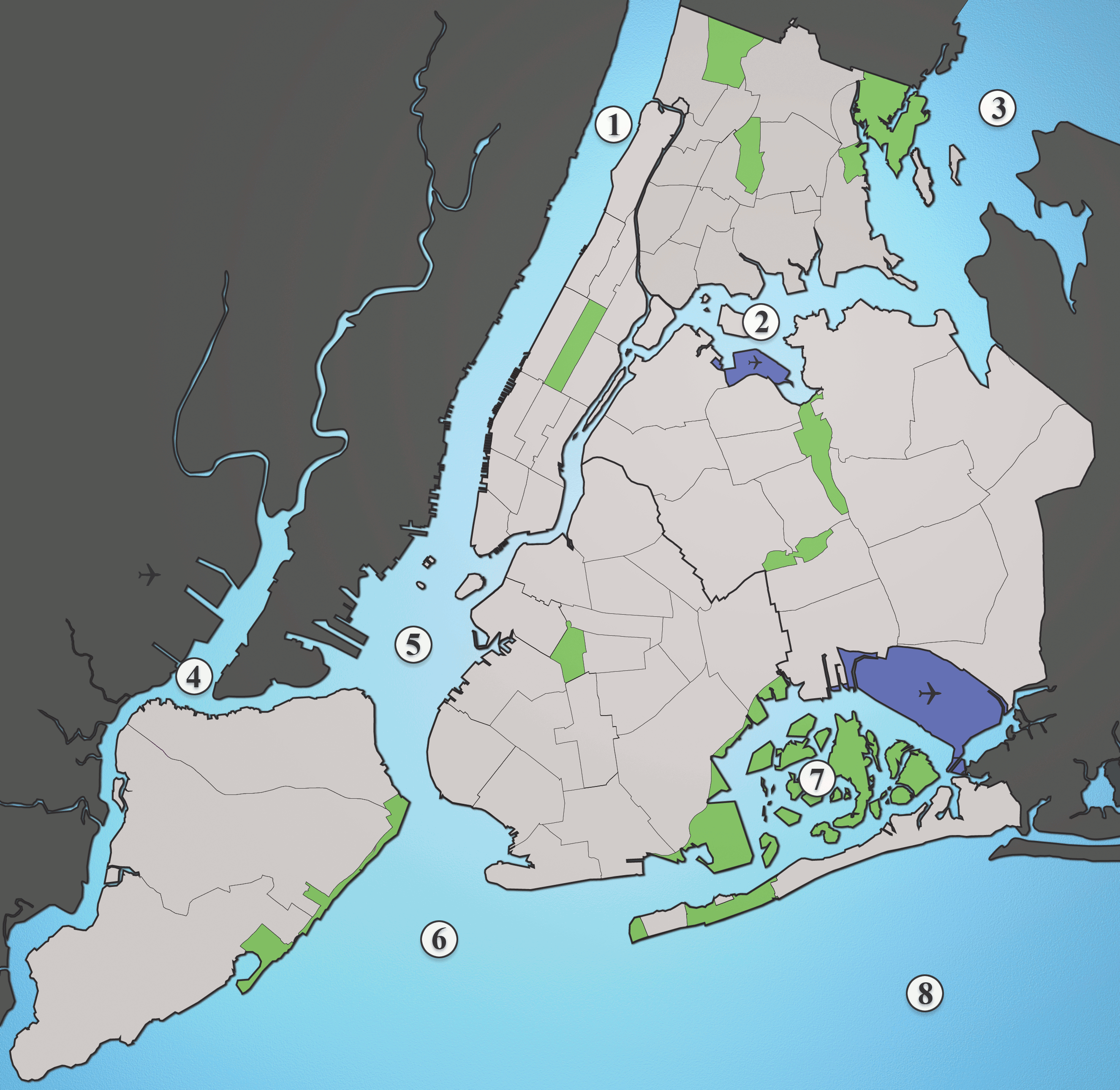
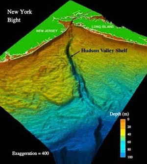
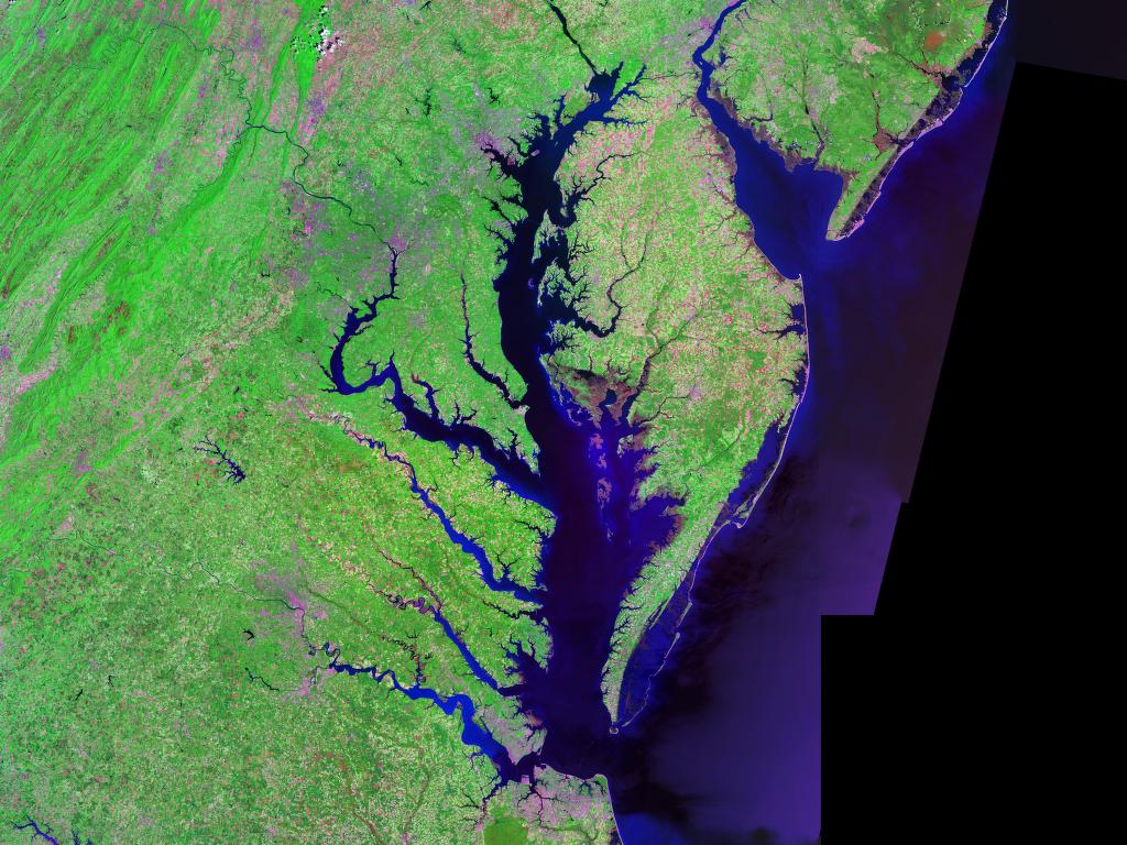
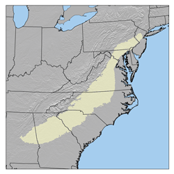
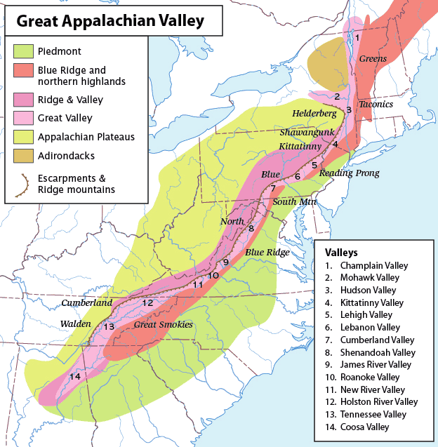
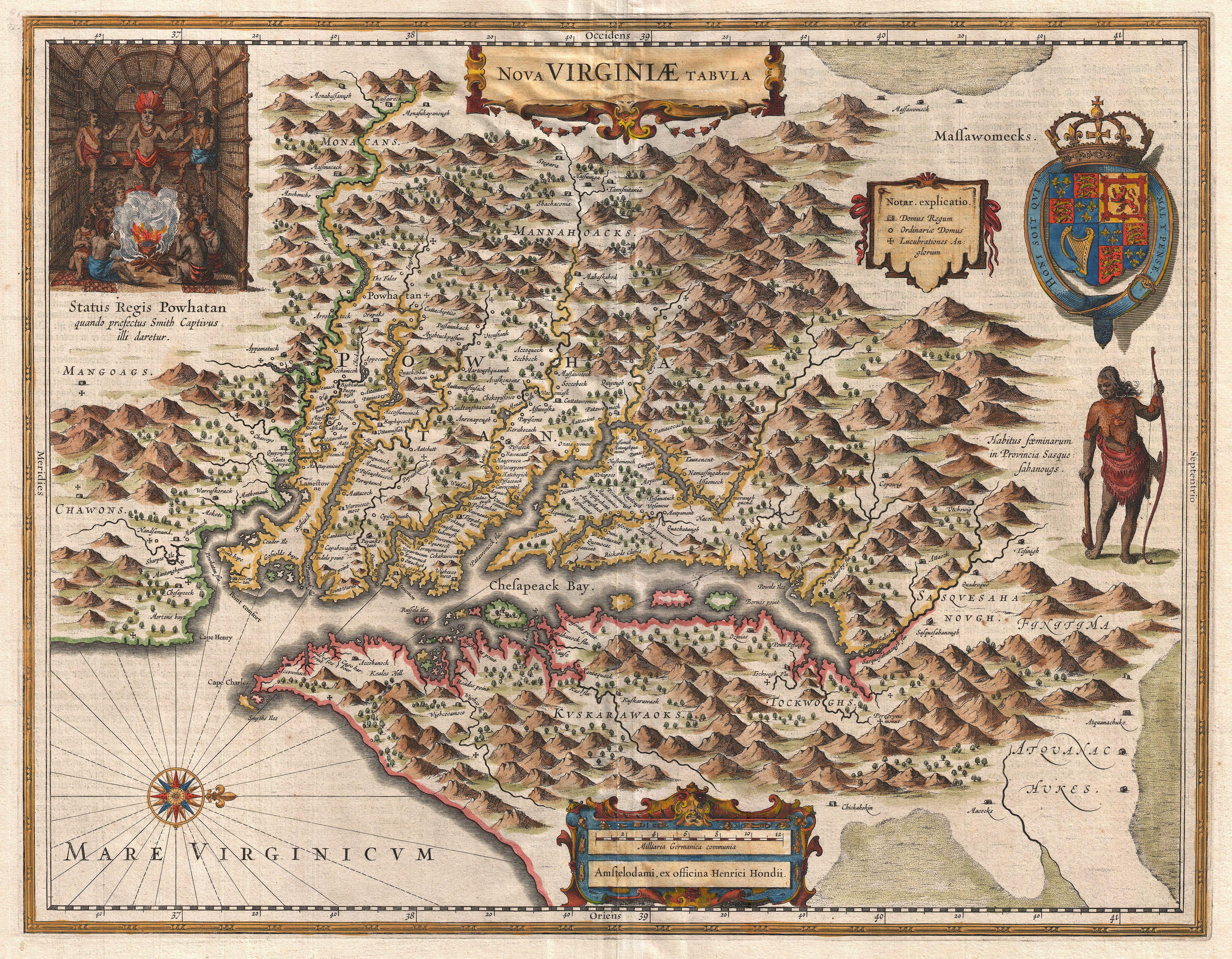
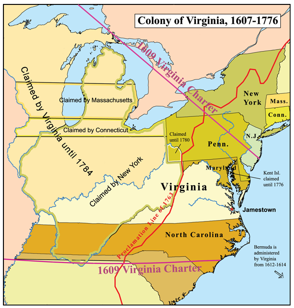
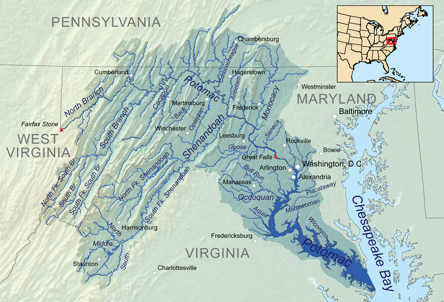
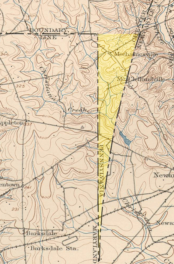
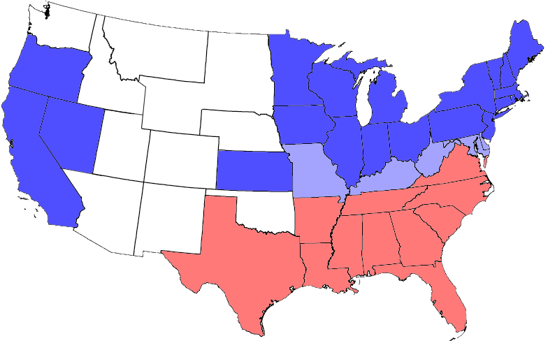