|
Reflections 2013
Series 2
January 26
Canadian Trio II a: Ottawa-Gatineau Yesterday
| | Before we get on the train to Ottawa, which we'll do in the next posting—and it's a city I've really gotten to like--we have to clear up some questions that had confused me, and perhaps readers as well. Why is Ottawa off the beaten path from major cities near it that line up so neatly? Why was Ottawa chosen as capital? Just what was it the capital of before it was the capital of all Canada? I remember on my day trip there years ago that Hull was across the river. What's the relationship between Ottawa and Hull? Why is Hull now called Gatineau? Ottawa was founded separately, but isn't it really an across-the-river child of Hull? Why is Hull—now Gatineau—not the capital? | | | | Not knowing how to best unravel and rethink this history, I thought it wise to let Champlain start it all out for me, since, while he was actually the second European to visit the area of Ottawa-Gatineau, he was the first to describe it, and actually give names to a couple of landmarks. We can try to see what he saw. Reading up more on him, I also find that his body of work is even more impressive than I'd thought. An additional advantage is that he ties together the three principal stops on this Canadian Trio trip, Tadoussac on the Saguenay, Québec, and Ottawa-Gatineau. He also ties in our quick stops in Montréal and our stop in Lake Champlain in 2011. | | | | Samuel de Champlain Champlain's wealthy uncle sent the young Champlain as an observer on a transatlantic voyage in 1599-1600 to the West Indies and Mexico City, an area one doesn't associate Champlain with. On his return, he assisted his ill uncle with his business affairs, but the uncle then died in 1601 and Champlain inherited his fortune, which allowed him great independence and the ability to explore without concern about financing from others. He then embarked on his first trip to North America, again as an observer, but this time a fur-trading expedition arriving in the Saguenay region in Tadoussac in 1603 (2013/1). He was anxious to see where Cartier had been 68 years earlier in 1535, and at this point created a map of the Saint Lawrence River. | | | | He joined a second expedition to New France in 1604 and focused this time on Acadia, which, as we've said in the past, is today not only the area of much of the Maritime Provinces, but also included what is today some of the Atlantic coast of New England. He helped establish, with others, the Habitation (Fort) at Port-Royal in 1605, France's first successful settlement in North America. The settlement was later moved upstream to today's Annapolis Royal, Nova Scotia. He used this as his base until 1607, during which time he explored the coast as far south as Cape Cod, another area I never associated Champlain with, where he considered establishing a settlement near today's Chatham, although he never did. | | | | He then set out in 1608 on his own expedition to New France, this time back to the Saint Lawrence. After again stopping at Tadoussac, he landed at Cap Diamant / Cape Diamond, the promontory of Québec (City) and built down at the river level there another wooden, fortified Habitation, this one consisting of three principal, two-story wooden buildings, protected by a stockade and moat. This was the foundation of the city of Québec, which will be discussed more completely in the upcoming Québec posting. | | | | In 1609, Champlain went south of the Saint Lawrence to explore what is today the Richelieu River and Lake Champlain. This is when he stopped on Isle La Motte, Vermont, described in 2011/24, his second entry after Cape Cod into what today is the US. In 1611, north of Lake Champlain on the Saint Lawrence, he established a fur trading post on the island of Montréal. It developed into a settlement initially called Ville-Marie (City of Mary), but was eventually named after the mountain behind the settlement, today in the middle of the city, that Cartier had named "royal", Montréal (Middle French réal is in modern French royal). | | | | Champlain had been proceeded on the Ottawa River in 1610 by Étienne Brûlé, the first European on the river, on his way to explore the Great Lakes, but three years later, in 1613, hoping to find a body of water which we now know as Hudson Bay, Champlain traveled into the western wilderness up the Ottawa River, and later wrote the first description of the area. In 1615 he went up the Ottawa a second time, then went west to Lake Huron and south to Lake Ontario, entering for the third time what is the US and staying in the region of Lake Oneida in New York State. He returned to Québec the next year. From 1620 on to the end of his life he spent his time focusing on the administration of Québec rather than on exploration. | | | | With this summary, let's look at Champlain's route (Map by Eric Gaba) (click to enlarge). As for Acadia, Port-Royal (here unmarked) is on a bay on the west coast of Nova Scotia (Nouvelle-Écosse) directly across from Saint John and due west of Halifax. His first stop in today's US would be down the Atlantic coast here to Cape Cod. Now trace his various routes down the Saint Lawrence to Tadoussac (here unmarked) at the mouth of the Saguenay. Québec is right where the Saint Lawrence narrows (note Lévis opposite) and virtually exists because of that narrowness. Montréal is upstream, and Lake Champlain south of it. West of Montréal, note how the Ottawa River takes off at about ten o'clock from the Saint Lawrence, which then continues at about eight o'clock to Kingston on Lake Ontario, an important location for the later history of Ottawa. | | | | We can see today's Ottawa-Gatineau, right where the Gatineau River joins the Ottawa, but this was a western wilderness, and Champlain didn't found or establish anything here, just observed. What he observed, we'll describe in a moment. And although it was wilderness then, note that ensuing history put a major provincial border right down the river, so that Hull/Gatineau when founded later, would be in Lower Canada (Québec), and Ottawa in Upper Canada (Ontario). This division has to be the reason why, what might have been consolidated as one city, never was, and to this day, the Ottawa-Gatineau metropolitan area is referred to as the National Capital Region, even though only the southern half of it, Ottawa itself, is actually the capital. | | | | Upstream, Champlain cut over to Lake Nipissing, where today's North Bay is located. Continue on this map (Map by Kmusser) to see that lake. You can then see how he completed his loop via Lakes Huron and Ontario to Lake Oneida, east of Lake Ontario, and back to Québec. (Note on this map a geographic oddity. Travelers can go north on the Gatineau, and then a small portage will bring them to the headwaters of the Ottawa River, which they can then follow down to the mouth of the Gatineau again, making a rather unique loop trip.) | | | | Champlain in the Ottawa-Gatineau Area Coming up the Ottawa River from its split from the Saint Lawrence, he would have been in a wilderness area, which is how he left it. As he approached what are today the twin cities of Ottawa-Gatineau, the first thing he saw of particular interest was on his right, on 4 June 1613, when he saw "a river coming in from the north". He did not give it any name, but by the end of that century, a Gatineau family had established a trading post there and their name stuck. In later times, the city of Hull was founded to the left of the Gatineau River, and the city of Gatineau to the right. It's all Gatineau today. | | | | Almost directly opposite the Gatineau River, but just a bit further upstream on the left, the Ottawa side, he saw coming down from an extensive river bluff a broad waterfall, which seemed to him like a curtain, perhaps like a theatrical curtain, so Champlain named them les chutes Rideau, which is Curtain Falls. But what became a famous local landmark suffered one of those half-translations, so that today it's half English and half French. Today the landmark is known as Rideau Falls, and the river coming over it the Rideau River. What the Gatineau River is to Hull/Gatineau, the Rideau River—and importantly, the Rideau Canal—is to Ottawa. | | | | But the extensive river bluff on the left over which Rideau Falls cascaded continued on, and even then was one of the most recognizable features of the area. At a point upstream on the Ottawa from the Falls the Rideau Canal would be cut through the bluff, and right after that upstream, the Canadian Parliament would be eventually built along the edge of the bluff, and so the bluff would be misnamed Parliament Hill. It's no hill. On the river side is the beautiful bluff, and on the town side, the land slops up to the Parliament buildings, and then to the edge of the bluff but that doesn't make it a hill. Yet Parliament Hill it remains. Opposite Parliament and the Canal is the center of Hull (Gatineau) on the north shore. | | | | Finally, at the upstream end of Parliament, there are a few islands in the river, which then narrows drastically between them forming a waterfall in the Ottawa River itself. Although this area is much altered today, the falls at their best are about 60 m (200 ft) wide, and drop 15 m (49 ft). They apparently looked rounded to Champlain and reminded him of a cookpot, and he named them Chutes de la Chaudière, or Cookpot Falls. Again, his name for them has come down to us in half-translation, as Chaudière Falls. | | | | But these falls being in the middle of the river caused a major obstacle to river traffic, an obstacle then and in subsequent centuries, an obstacle to the fur and logging trades. Champlain had to portage around them in order to continue upstream. Since the "Ottawa side" had the bluffs, and the "Hull side" was relatively flat, the portage was on the Hull side, and for that reason, two centuries later it was in Hull—at this portage—that the first European (non-native) settlement in the area was made, one that would eventually spread to both sides of the river. | | | | | | How did the word chaudière enter English? As the word "chowder", named after the cookpot the soup was cooked in. The soup, and the word to describe it, were introduced by Breton fishermen into Newfoundland, and then spread to New England. Consider both the fishermen connection and the French connection when you enjoy your next bowl of clam chowder, ladled out of a chaudière on the stove. |
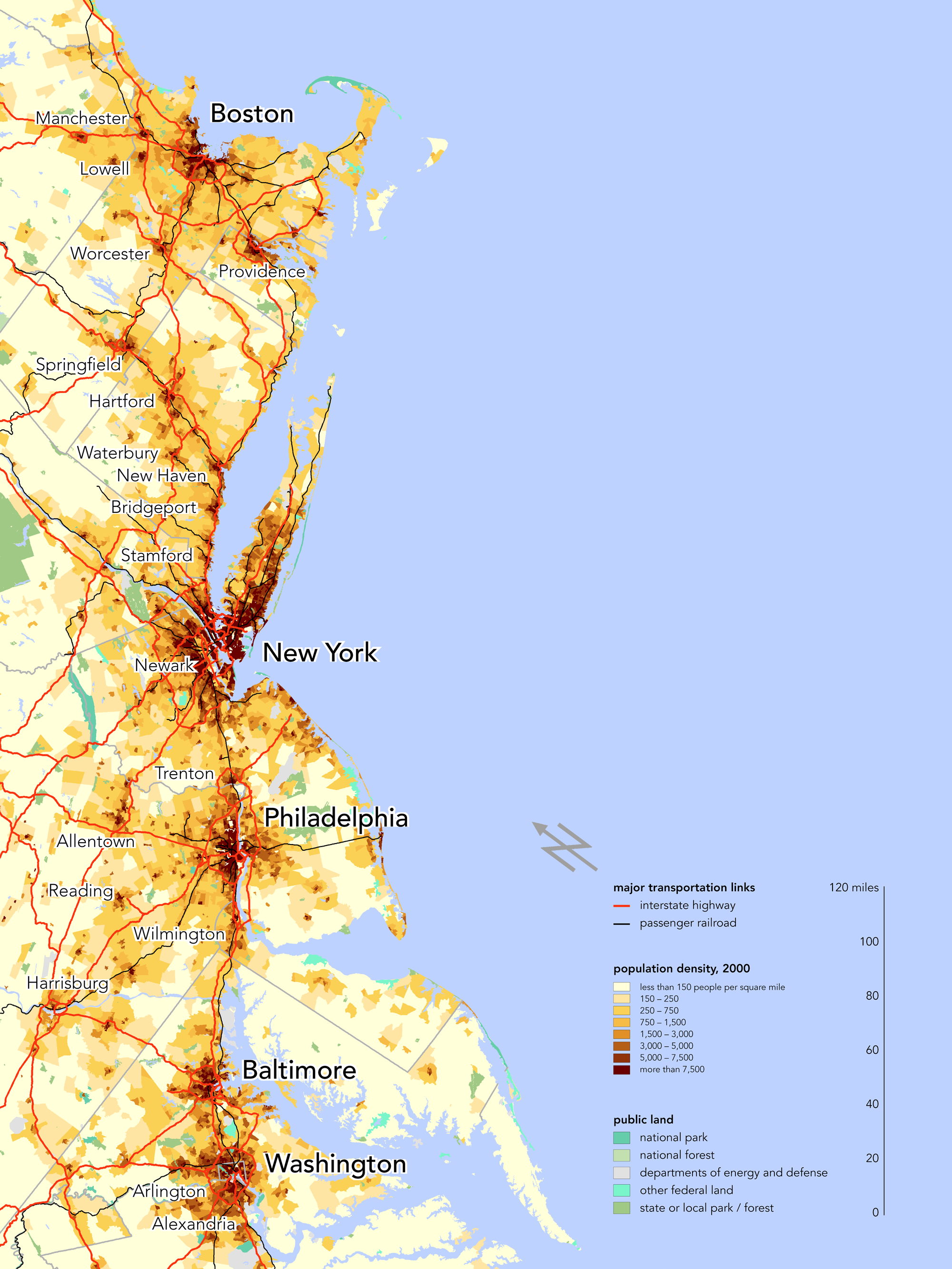
| | | | Philemon Wright After Champlain's visits in 1613 and 1615, this wilderness area remained wilderness for just under two centuries until the next non-native visit, and this time it was an American who arrived here, a man from Woburn, Massachusetts. As a young man, Philemon Wright had served with the rebel forces in the American Revolution some years before his move, so there doesn't seem to be any indication that he was a Loyalist coming to what would become Canada, he was just another New Englander seeking opportunity who decided to move north--actually, northwest. Apparently he felt Massachusetts was getting too crowded, and was more interested in an isolated area with no settlements. There is a bit of irony in the fact that previous members of the Wright family had been among Woburn's earliest families a century earlier, coupled with the fact that Philemon Wright is regarded as the founder of both the cities of Gatineau (Hull) and Ottawa. | | | | Before making his definitive move, he visited the valley of the Ottawa River three times, in 1796, 1798, and 1799. Of the prominent geographic markers he had seen, he decided that the best location for a settlement would be next to Chaudière Falls, where he found good soil. He specifically chose the north shore of the Ottawa River at the falls because that was where the portage around the falls was and a natural traffic route. Thus it was these falls and this portage around them on the north side that made this the founding settlement of the entire National Capital Region. | | | | Write convinced a group of settlers, five families and 25 laborers, to come with him in 1800 to found a town and settle down in the area. Although the settlement was agricultural, Wright and his family became deeply involved in the lumber trade. The town he founded was named Wrightstown, and it was not until it was incorporated in 1875 that it was renamed Hull, after Kingston upon Hull in Yorkshire, whose name is usually shortened to Hull, which is actually just the name of the river it's on. Thus Hull, Québec is the basis for all settlement in the National Capital Region on both sides of the river. | | | | Then in 2002 came the municipal consolidation, the same one that formed Saguenay from its constituent cities (2013/1). Hull itself, whose downtown faces downtown Ottawa, but which extends downstream to the Gatineau River, was combined with the City of Gatineau on the other side of said river, plus two smaller downstream communities, and also with Aylmer, which lies upstream from Hull. But what name to choose? | | | | To my cynical mind—and I'm not alone—the name of an English city, Hull, grated on francophone nerves in Québec. Hull was the oldest city in the merger. Hull was the most central city in the merger, with the most prominent downtown. Yet the francophone name Gatineau was chosen. The main reasons given were that the former city of Gatineau was more populous than Hull, that it was, very obviously, the name of the river between these two areas, along with the name of the valley, the surrounding hills, and the nearby huge park, making the name Gatineau less restrictive than Hull. And then, it's a francophone name, too. | | | | Actually, this line of thinking is quite reasonable, but it does give the impression that it wasn't the former city of Hull that expanded (which it de facto was), but the former, less significant city of Gatineau, even though Hull remains the downtown of the expanded city. Incidentally, while the parts of Saguenay are called arrondissements,, in Gatineau they are called secteurs / sectors, so one speaks today of the "Hull sector of Gatineau". Also, reference is still sometimes made to the National Capital Region as Ottawa/Hull, rather than Ottawa/Gatineau, but that will continue to change. | | | | At this point, let's look down from this satellite view of Ottawa-Gatineau (click to enlarge) to see what it was that Champlain found and where Wright settled, but in this modern overlay. Start at the right and come up the Ottawa River, passing on the north bank the "Gatineau sector of Gatineau" (!!!), then the Gatineau River, then the Hull sector of Gatineau. But before you reach the center of Hull, you see on the south bank where the Rideau River comes over the bluff to form Rideau Falls. You can also see something not mentioned earlier, that an island called Green Island splits the river, so that in reality there are two falls—the "curtain" Champlain named them for is "drawn open" in two parts. Disregard the first bridge, but pay attention to the second one, the Alexandra Bridge, for later reference. Note that point of land, still up on a bluff, that reaches out next to the bridge. That's Nepean Point, which sports a statue of Champlain (pictures later) and gives an excellent view over to Parliament Hill, on the other side of the bridge. Between these two points is the north end of the Rideau Canal, which avoids the problem of Rideau Falls as well as other falls further upstream, before it ties in, for now, to the Rideau River. | | | | West of the Alexandra Bridge, downtown Hull, and Parliament Hill, two other bridges cross over a cluster of islands. To the left of them is Chaudière Falls, where it all started. The first of these bridges is Portage Bridge, a reference to the portage around the falls that started it all, and the second bridge, closer to the falls, is appropriately the Chaudière Bridge. | | | | The area around the falls was once heavily industrialized, particularly in the 19C, and most notably by the logging industry. That, damming in the river, and water diversion for power stations, have greatly altered the appearance of the falls, which today are, at best, cascades. At worst, in the summer, they virtually disappear entirely. While we will look at Ottawa pictures later, we can now look at what the area around the Chaudière Falls (Photo by Shanta, from a hot-air balloon) looks like today. This view is downstream (eastward), and has the remnant of the dammed cascade/falls in the foreground, between islands. Nearest is the Chaudière Bridge, then the Portage Bridge, both leading to the historic center of Hull on the left. In the distance, the Alexandra Bridge leads to the historic enter of Ottawa, so we can see now that the two centers are very close, but not opposite. To the right of the Alexandra Bridge is the entrance to the Rideau Canal, which is not visible, and the Parliament Buildings atop the bluff. | | | | Seeing that so much of this historic area is now parkland, with little to see, one begins to wonder why. What happened to all that industry? What happened to the historic center of downtown Hull? The answer is fire. The worst one was the Hull-Ottawa fire of 1900 (click to enlarge), which, as the name says, started in Hull, and tore through its wooden houses. To make things worse, lumber companies had stored stacked lumber on the riverbank, much of which fueled the fire. The dashed line is where the fire was believed to have crossed the river (note the larger size of Chaudière Falls in 1900). On the Ottawa side, winds kept the fire from Ottawa's downtown, lying further east, so the fire moved south along Ottawa's western flank instead. The map shows that the river bluffs turn inland here, and one wonders if the higher ground of downtown helped protect it. In any case, the fire answers the above questions. (Follow the river bluffs to Parliament Hill on Wellington Street. Note that the locks for the Rideau Canal are directly adjacent to Parliament, and that the Alexandra Bridge to Nepean Point is "proposed" on this map, to replace a ferry.) | | | | We now have the history of Hull, but don't know yet why, after Wrightstown (=Hull=Gatineau) was founded in 1800, its southern suburbs didn't remain just that, southern suburbs. That they instead become another city, is not too surprising, given the provincial border in the river, but why did that new city's importance surpass that of the parent city? And beyond that, if one of them were to become the national capital, why was it the new city and not Hull? | | | | Corridors The answer why this region rose in importance goes back to its location: it is remote, something even Champlain had been aware of. It's off the beaten path, and that's why Ottawa was founded, and also one of the reasons it became capital. Let's start by seeing what we mean by "beaten path": transportation corridors. | | | | There are two transportation corridors in Northeastern North America, and by pure chance, they're parallel to each other, simply because the seacoast of the Middle Atlantic and New England states in the US is parallel to the lineup in Canada of the Saint Lawrence River, Lake Ontario, and Lake Erie. | | | | Look first at the Boston-Washington Corridor (Map by Bill Rankin), part of the northeast megalopolis in the US. It's the heavily urbanized area stretching from the northern suburbs of Boston to the southern suburbs of Washington. About 50 million people live here, about 17% of the US population on less than 2% of the US land area. It's nicknamed BosWash, also BosNYWash to point out its largest city. It's a connection of the four areas of first settlement from Britain. Historically, when coastal shipping was more important, ships connected these cities, now roads (US1, I-95) and rail do: this is Amtrak's Northeast Corridor Service (Map by SPUI). | | | | In Canada, the direction of settlement up the Saint Lawrence and along the first two Great Lakes was the impetus that developed the Québec-Windsor Corridor (Map by Videoman). Observe the cities lining up along the water, including Québec, Montréal, and Toronto, down to Windsor, opposite Detroit. This corridor is the most densely populated and heavily industrialized region of Canada, spanning 1,150 km (710 mi), and including over 18 million people, or 51% of the national population. Traffic on this route is by water, road, and rail, including, for rail passengers, VIA Rail Canada's Corridor Service (Map by Airodyssey & MammothStrider). Now, aside from expanded local service in the southern end, notice the oddity of Ottawa. It's out of line. Why is Ottawa not on the Saint Lawrence? Being off to the side requires special train connections to it from both Montréal (orange) and from Toronto (lilac), as opposed to through trains (green). Why doesn't Ottawa line up with the other cities? It's because of anglophone Canadian perceptions of the War of 1812. | | | | War of 1812 The War of 1812 is one that even people who know enough history to know one war from another tend to be very vague about. It could be because of the name. If, say, the Korean War had instead been called the War of 1950, people would probably have trouble remembering what it was all about as well. There is a perceived de facto feeling in many quarters that "nothing happened" of importance. I wasn't totally sure myself what caused it or what happened, so I looked up the background. | | | | It took place less than two decades after the 1793 Treaty of Parks ended the American Revolution. It was a war declared by the US based on perceived provocations from the British, an attempt to resolve issues remaining from the Revolution. There were trade restrictions caused by Britain fighting Napoléon, the impressment (forcing to serve, similar to shanghaiing) of American merchant sailors into the Royal Navy, outrage over insulting treatment on the high seas, such as illegally boarding American ships to remove deserters from the Royal Navy, and British support of Native American tribes against American expansion. In addition, there was the (mistaken) feeling in the US that British North America (Canada) could still be convinced to join the US. | | | | The war was fought in three principal theaters: 1) on the US east coast and at sea, 2) in the US South, and on the Gulf Coast, and 3) in the north, on the border between the US and British North America (Canada), involving both land and naval battles. The war ended with the Treaty of Ghent, in which both sides returned territories they had gained, which possibly explains the feeling that "nothing happened". However, both the US and the people of British North America (Canada) felt they'd won, since each young nation had stood its ground. | | | | But it's the perception of the war two centuries later that is so odd because of its variability. Is popular memory of the War of 1812 non-existent, partial, or intense? It depends on which of the participants you ask—actually, their descendants. Here how it works out: | | | | | | A) For the British, popular memory of the War of 1812 is non-existent, a forgotten matter. Mention the date, and Brits will talk about Wellington, Waterloo, Moscow, and Napoléon, but will likely no longer have any concept of anything happening in North America, nor will other Europeans.
B) Talk to francophone Quebeckers, and it'll be the same, popular memory will be non-existent. The popular memory that they will have of fighting the British would be on Québec's Plains of Abraham in 1759 during the Seven Years' War/French and Indian War, which led to Québec becoming British. You'll see monuments to that event in Québec, but mention 1812, and it'll be a non-starter.
C) In the US, there is partial popular memory, and that recollection will completely involve the US having repelled the British, with little to no memory of conflicts with Canada. Americans will remember the British burning Washington, but then being repelled. They'll remember the British invasion of Baltimore, but only because Francis Scott Key the morning after still saw "the rockets' red glare, the bombs bursting in air" proving that "our flag was still there". There is also vague memory of Andrew Jackson repelling the British at the Battle of New Orleans. Move north, and that partial memory dissolves, except perhaps for some recollection of Commodore Perry having a flag saying "Don't give up the ship" in the Battle of Lake Erie, which he won. But talk about Americans invading what became Canada, or the British invading the US over the Canadian border, you will surely find that Americans have developed total amnesia on that subject, and American popular memory about it in the 21C will be non-existent.
D) In sharp contrast to the obliviousness shown in the US for the northern campaigns of the War of 1812, and for the fact that it is a forgotten war in Britain and in Québec, the popular memory of it is very intense among anglophone Canadians, who took it, and take it today, very, very seriously, and most particularly in Ontario, where much of the action took place. When Americans consider the northern events at all, it's with a feeling of balance, since everyone went back to their original border positions. The British had invaded areas like Michigan, Ohio, and Maine, and the Americans had invaded, or tried to invade, parts of southern Ontario, including the Niagara Falls area. The Americans attacked York (Toronto), because of which the British attacked Washington. But in actuality, Upper Canada (Ontario) emerged from the war with a sense of unity and pride for having defended themselves from an invader, and continue to consider it a Canadian victory.
|
| | | | I first became aware of the feelings about the War of 1812 when in Ottawa and seeing some of the war monuments and memorials in and about Confederation Square, the second most important ceremonial site after Parliament Hill. The Valiants Memorial has busts of important Canadian military leaders in five periods of time. Two newer ones are the World Wars, and the oldest one is the French Regime, but the middle ones are from the American Revolution and the War of 1812. In addition, while there were some ceremonies in the US in 2012 to commemorate the Bicentennial of the War of 1812, in Canada, numerous ceremonies took place, and it was a much more major celebration, and with greater significance. | | | | A February 2012 poll of Canadians suggested a list of items that could be used to define Canadian identity. The fact that Canada has universal health care came in first, at 53% (!!!) But coming in second, at 25%, for what defines Canadian identity is the fact that Canada successfully repelled an American invasion in the War of 1812. | | | | [An aside: English speakers need a far better name for the War of 1812, not only to keep it separate from Napoleon in Moscow in 1812, but also to identify the events more clearly. Americans have referred to the anti-British was as the Second War of Independence, but that's far too strong. (That name also shows a diametrically opposite attitude from the Canadian point of view.) It was primarily against Britain, so it shouldn't refer to Canada. There already is an easy answer, which other languages have figured out. This is what the War of 1812 is called in: | | | | | | German: Britisch-Amerikanischer Krieg
Russian: Англо-американская война / Anglo-amerikanskaya voiná
Italian: Guerra anglo-americana
|
| | | | Some languages do say it the English way (Dutch: Oorlog van 1812); others combine the above with the date (French: Guerre anglo-américaine de 1812), many admit it has more than one name. The German lead won't quite work in English, because if it were called the British-American War, it would seem to refer to British America, or Canada again, which is not intended. Therefore, the best route is the alternate; the name should be changed to the Anglo-American War, or perhaps, to use the other model, the Anglo-American War of 1812.] | | | | A Residual Danger Only when one fully understands the intense wariness, particularly in Ontario, as of the end of the War of 1812 can one understand Ottawa, and we're only talking about the development of Ottawa the city, not yet Ottawa the capital. | | | | The ease of invasion of British North America (Canada) indicated its vulnerability, and Britain began a period of strengthening defenses. This is when concern began to build about the Saint Lawrence River. Then, as now, it was the transportation corridor of Lower and Upper Canada (Québec and Ontario), and subject to a quirk of political geography. Look again at this map of today's Québec-Windsor Corridor (Map by Videoman), but concentrate just on water transportation, and think about the early 1800's. Both commercial and military shipping would come up the Saint Lawrence, accessing cities along the route, and enter Lake Ontario, up to York (Toronto) and beyond to the end of the lake. But there's one military problem. Between the Ontario cities of Cornwall and Kingston (see map), the south shore of the river is part of the United States, specifically, New York State. Militarily, this was particularly significant since Kingston had a British naval base and was an important point of operations during the war, as it was at the juncture of the lake, the river, and also the smaller Cataraqui River leading inland (more about that below). | | | | The Americans had attacked Upper Canada at Niagara (see map), and during the war, the British were constantly worried that the Americans would block the Saint Lawrence and attack shipping, particularly British military shipping, by cannon fire from the American (New York) shore. If they had done so, the lifeline between Québec and Montréal on the one side and Kingston and York (Toronto) on the other, would have been severed. There would have been no British supply route into Upper Canada (Ontario), where most of the land battles had taken place, and Britain would probably have had to withdraw from the area and/or surrender this entire area within a few months. Dispatches British officers sent after the war showed how astonished they were that the US had not done this. Even though the war was over, Britain continued to consider the possibility that it could happen just that way in a future conflict. | | | | Rideau Canal The solution that was reached was that that "danger spot" of the Saint Lawrence had to be avoided, and a secure water route around it chosen. The first part of the detour was obvious, since the Ottawa River (Map by Kmusser) deviated from the Saint Lawrence just southwest of Montréal and well before the New York border opposite Cornwall. Navigation would be easy up to the major settlement on the river, Wrightstown (=Hull=Gatineau). To complete the detour, it would then be necessary to build a canal from opposite Wrightstown down to Kingston (see map) on the northeast corner of Lake Ontario, and beyond the influence of New York State. | | | | Fortunately, flowing from the area where the canal would have to be located was the Rideau River flowing northeast up to the Ottawa River, and the Cataraqui River flowing southwest down to Kingston and Lake Ontario. Therefore, Britain commissioned an expensive project to be called the Rideau Canal, named after the upper of these two rivers, so that the Ottawa River and Rideau Canal would form the bypass of the part of the Saint Lawrence bordering New York State. Think of it as a triangle between the Montréal area and Kingston, with the New York border via Cornwall forming the longest leg and the bypass forming the other two sides. | | | | This is a map of the Rideau Canal today. (The canal is dark blue, other water is light blue, locks are maroon squares.) Because the end of the Rideau River ends in the Rideau Falls, for the canal to go through from the Ottawa River, a cut had to be made in the river bluffs west of the falls next to what would later be called Parliament Hill. To allow for the change in height from the Ottawa River level to the bluffs level, the canal's northern end would start immediately with a series of eight locks. These northernmost locks are the most famous ones, because they are the most visible, being right in the center of Ottawa, and the most clustered together. Because there are other falls on the river in southern Ottawa, the canal continues to avoid the river in town, and joins it after the upstream falls. From that point on, the river itself had to be modified to form the canal. (On the map, the light blue river at the north end can be distinguished from the canal.) The canal connects with several lakes before working its way to the upper Cataraqui, a river that was also extensively modified, and down to Kingston, with many more locks on the way, for a total of 45. The canal is 202 km (126 mi) long and is thus built over two watersheds. | | | | | | Rideau in both French and English is ri.DOH, although in English it can also be RI.doh. Cataraqui is a French name and should rhyme with the first part of "qui[che]". Unfortunately, English speakers have gotten their tongues wrapped around the word and the pronunciation has been altered to rhyme, rather surprisingly, with the first part of "qua[ke]". Go figure. |
| | | | The War of 1812 lasted until 1815, and just over a decade later, canal construction began in 1826, and lasted six years, until 1832. Construction was supervised by Lieutenant-Colonel John By of the Royal Engineers. But the biggest irony of all is that the canal was never, ever used for its intended purpose, to avoid military attack, since no hostilities with the US ever erupted after the War of 1812. | | | | However, the canal did serve a commercial purpose for a number of years. This is because the Saint Lawrence used to have a series of rapids in the stretch the detour avoided, so the canal was easier to navigate, making it a busy commercial artery. It also played a role in the early development of Canada, since it was the main route for immigrants going west into Upper Canada (Ontario) and for natural resources such as lumber, grain, and minerals to go east. In these years, the Rideau Canal competed with New York's Erie Canal, since it allowed Montréal to compete commercially using the Rideau with New York City using the Erie Canal. But this heyday of the Rideau Canal lasted for only about 17 years, because by 1849, the rapids had been tamed by a series of locks on the Saint Lawrence, and shippers moved back to the more direct route. | | | | Today, the Rideau Canal is operated by Parks Canada as a recreational waterway, with the locks open for navigation from mid-May to mid-October. In 2007, it was registered as a UNESCO World Heritage Site, recognizing it as an extensive, well-preserved, significant work of human creative genius, and particularly one that reflects the military history of North America. It is the only canal dating from the early 19C canal-building era in North America that remains operational along its original route, with most of its original structures intact. | | | | Ottawa, the City The peak of the triangle formed by the Saint Lawrence and its bypass via the Ottawa River and Rideau Canal was a point on the Ottawa River opposite Wrightstown (=Hull=Gatineau), which was the only settlement in the area anyway, so logic would demand that Wrightstown should see the economic growth that more traffic would bring, and perhaps even spread its borders, but that's not exactly what happened. | | | | Canal construction was overseen by chief engineer Colonel John By, who set up a military barracks on what is today Parliament Hill, immediately west of the canal cut in the bluffs. He also established a small settlement near the canal to house the workmen, and this settlement, founded simultaneously with the start of canal construction in 1826, was named Bytown after him. By also laid out the streets on both sides of the canal. The neighborhood bordering Parliament Hill on that side of the canal he called "Upper Town", since it was further upstream on the Ottawa River. This name is no longer used, as the area, which is today the city's financial and commercial hub, is now just called Downtown, with Centretown just south of it. The neighborhood across the canal and further downstream he called "Lower Town", a term still used today. Bytown's population grew to 1,000 as the Rideau Canal was being completed in 1832. Almost three decades after its founding, Bytown was incorporated into a city in 1855, at which time it was renamed Ottawa after the river. It was two decades later, in 1875, that Wrightstown became Hull, thus completing the obliteration in the city names of the two founders, Philemon Wright and John By. | | | | The reference is always that John By founded Ottawa, which is true, but it's presented as though the settlement were a lightning bolt out of the sky, and not that it was an extension of the established settlement Wright had already founded across the river a quarter-century earlier. It's surely the fact that the provincial border runs down the Ottawa River that has prevented any physical merger between the two sides, from the earliest days onward. However, in 2001, Ottawa merged with a number of its suburbs on the Ontario side of the river, and 2002 was when Hull merged with Gatineau and other areas on the Québec side to be renamed Gatineau. | | | | Ottawa, the Capital It's a known fact that Queen Victoria "chose" Ottawa to be capital, although the story is rife with urban legends as to how it happened, including her sticking a pin in the map or being impressed by watercolors of the area. Anyone who believes any of that nonsense is disrespecting her, the British government at that time, and the Canadian authorities at that time. Yet those myths go on. | | | | The way governments work, even then, before Canada was independent enough to make its own decisions, is that local Canadian officials advised British officials, who advised Victoria, who then made her "choice". That's how she "decided" during the course of one single day, New Year's Eve, 31 December 1857 to choose Ottawa. Incidentally, Bytown, feeling it was a candidate, had changed its name from the backwoodsy Bytown to the more elegant Ottawa just two years earlier, in an attempt to polish its image and improve its candidacy. Even then, the losing candidate cities still felt that Ottawa didn't have sufficient size or gravitas to be capital. | | | | Which cities were the other candidates? Using the period stylings of their names, they were York (Toronto), Fort Frontenac (Kingston), Kebec (Québec City), and Mont Royal (Montréal). And the irony of it is, each of these four larger cities had already taken turns being capital at one time or another. So why Ottawa? | | | | A superficial reason is that the other four had been quibbling and arguing among themselves, each supporting itself, but that's not fundamental. There are two good reasons why Ottawa in the back woods was chosen. | | | | THE AMERICAN BORDER The other four candidates lined up in a row then, as they do now, to form the transportation corridor of the Saint Lawrence plus Lake Ontario, and therefore, all four of them were and are close to the American border. All four of them had seen American invasion, Québec and Montréal in the American Revolution, and Toronto and Kingston in the War of 1812. Even though 1857 was over four decades since the end of hostilities in 1815, no one wanted the capital to be that vulnerable. So in other words, it comes back to the Rideau Canal helping to form the bypass of that danger zone via Ottawa that was fundamental in this decision. | | | | THE PROVINCE OF CANADA One problem in understanding history is that we look at it through today's eyes, and we seem to be talking about Ottawa becoming the capital of Canada. Here, we are not, at least not yet. Canada didn't exist, so we have to go back pre-Confederation, before 1867 (see 2011/25). It's easy to picture Canada today as one large unit, but it was only at the time of Confederation that the Maritimes joined the nascent Canada, and well after that that the Western Provinces were added. Actually if you picture the transportation corridor along the Saint Lawrence and Lake Ontario, you'll have a better idea of what Ottawa was chosen to be the capital of. | | | | In a nutshell, in the half-century between 1791 and 1841 there was the Province of Upper Canada (the core of Ontario, on the Great Lakes and Saint Lawrence) and the Province of Lower Canada (the core of Québec, on the Saint Lawrence). These two were joined together in 1841 to become the Province of Canada (Map by Astrokey44), also known as the United Province of Canada, also the United Canadas. The successive capitals of the Province of Canada were, in this order, Kingston, Montréal, Toronto, Québec. When Ottawa was named capital in 1857, it was named capital of the Province of Canada. The above map includes western and eastern regions that were of low population, since the bulk of the population lived, then as now, along the transportation corridor on the Saint Lawrence and Lake Ontario. Look once again at the modern map of VIA Rail's Corridor (Map by Airodyssey & MammothStrider). Using this as a guide, notice how Toronto and Kingston are both to the west—and in Ontario—while both Québec (City) and Montréal are both to the east—and in Québec. In addition to the fact that Ottawa is set back from the American border, it was chosen at the time as the capital of the Province of Canada because it was CENTRALLY LOCATED between the four large cities of the day, and, with Hull, represented both halves of the Province of Canada as it then existed. For the record, Ottawa to Toronto is 353 km (219 mi) and Ottawa to Québec is 376 km (233 mi). It's a coincidence that it's that close to being centrally located, and looks like it had been planned. | | | | This "new" British colony called the Province of Canada only lasted another decade until Confederation in 1867, when the Province of Canada joined with the Maritimes, and then was itself once again split up into Ontario and Québec, Ottawa then being at that point confirmed to become, in 1867, the capital of the entire Confederation. With Canada's growth, Ottawa no longer is centered in the country. But then Washington was centered in the Thirteen Colonies, and Canberra was centered between Sydney and Melbourne, and with those countries' growth, the capitals are no longer nationally centered, either. | | | | National Capital Region While Ottawa and Gatineau (Hull) were never joined together, they still function together. Many government employees live on the Gatineau side of the river, and government offices and national museums befitting a capital are located there as well. As a matter of fact, there is an official federal designation known as the NCR, the National Capital Region (Map by Seblini), which roughly corresponds to the Ottawa-Gatineau metropolitan area, the only metropolitan area in Canada that straddles a provincial border. The NCR therefore lies within two provinces, since there is no special capital district in Canada such as the District of Columbia for Washington, the Distrito Federal for Mexico City, or the Australian Capital Territory for Canberra. While proposals have been made to separate the NCR from the two provinces and make it its own legal entity, they have never come close to passage, and there is currently no political will of significance to go in that direction. | | | | Of the well-known Canadian cities, in the 2011 census, the largest were these: | | | | | | Over a million: Toronto 2.6; Montréal 1.6; Calgary 1.1
In the 800 thousands: Ottawa; Edmonton
In the 600 thousands: Québec; Winnipeg; Vancouver
|
| | | | However, Ottawa's situation is misleading, and de facto, it should appear a line higher, since the National Capital Region of Ottawa-Gatineau has a population of about 1.5 million. | | | |
| |
|
|
|

