|
Reflections 2013
Series 19
October 23
China III: Macau
| | Macau I always told myself that, if I ever got to Hong Kong, I'd visit Macau as well, and I'm glad I did so as a one-day side trip out of HK. They're both unique enough that I wouldn't have wanted to have missed either. I kept them for a larger China trip, but in retrospect there's enough to keep you busy in the pair of them that they're worth a trip on their own. | | | | If you're looking for a Portuguese-Chinese blend, here's your place. If you want a very historic Old Town to visit, here's your place. If you're a gambler (which I am not), you may enjoy it more than Las Vegas, so here's your place. If you've never come across a location that's cloned itself, so that now there are effectively two of them, here's your place. | | | | The Estuary We pointed out earlier that Guangzhou (Canton), Hong Kong, and Macau form a triangle around the delta of the Pearl River Estuary (Map by Alanmak, Serg!o). Guangzhou, not shown on this map, is at the inland head of the estuary, the other two at the mouth, on either side. Hong Kong is huge in size when compared to Macau, which you can effectively walk across, which I, to a modified extent, effectively did, despite the horrendous heat. | | | | A Mini-History Here's the history of Macau in a nutshell. In the early 1500's Portuguese sailors anchored ships there, built storage sheds, and did some trading. But Macau didn't became a Portuguese colony until 1557, but then continued as a trading post. That's something like twice as long ago as when Hong Kong became a British colony in 1842. The establishment of HK cut into Macau's trade, and a slow decline set in. Both were turned over to China in the 1990's, but Macau was the last, in 1999, making it the last European territory in continental Asia. As to how and when gambling came to Macau, we'll discuss that when we get to the casinos. | | | | The People 95% of the population of Macau is ethnic Chinese. 47% of the residents were born in China, mostly in adjacent Guangdong Province. Some 2% of the population is either of Portuguese descent, or mixed Chinese-Portuguese descent, the latter often called "Macanese". Macau is the most densely populated region in the world. Its population density in 2013 was an amazing 20,497 persons per square kilometer. | | | | The Name Macau, which can also be spelled Macao, rhymes with "cow" no matter how you spell it. The O-spelling had been the traditional Portuguese spelling, but Portugal has now abandoned it in favor of exclusive use of the more familiar U-spelling. English does, unfortunately, use both, and the Macau government is tolerant of that and accepts both, but I find that to be nonsense and use and recommend the accepted Portuguese spelling "Macau". As for the origin of the name, that will come later as part of the visit. | | | | The Pataca It's so unusual to have three customs areas (China, HK, Macau) with three entry requirements (strict only in China), that it shouldn't surprise that there are three currencies. Sort of. China has its currency, HK has the HK dollar, and Macau would seem to have its pataca. The pataca is backed by foreign exchange reserves, which is currently—what else—the Hong Kong dollar. The exchange rate is pegged, and is, technically about 103 patacas to 100 HK dollars (why couldn't they even it out?). But it's all a bit farcical. About 70% of the money in circulation in Macau is actually HK dollars, and patacas account for only 30% of the money supply. The HK$ is acceptable everywhere in Macau, and is often preferred to the pataca. If you take patacas back to Macau, you might be able to exchange them back to HK$, but it's either extremely difficult or impossible to do so anywhere else. It's illegal in Macau for merchants to refuse accepting the pataca, but some casinos disregard that and refuse bets in patacas. Actually, although the HK$ is the de facto currency in Macau, the Chinese yuan (¥) is generally accepted there as well, given the hordes of Chinese coming over the border to either gamble or visit the Old Town, and I saw prices there in both HK$ and ¥ but never in patacas. | | | | A Most Curious Geography No matter what your interest in Macau, in my opinion, if you haven't reviewed its most curious geography, you'll miss more than you actually experience, either by a physical visit or as an armchair traveler. I'd checked the geography out carefully in advance, so I knew I could fit what I wanted to do in a single-day visit. As with almost everything, I learned in advance, I learned while I was there, and I learned more after the fact, as I was preparing this posting. I shall give you the nitty-gritty. | | | | Geographically, Macau started tiny, then added some land, then more landfill, and finally cloned itself, which is hard to believe, but true. To understand what we're going to visit, you have to realize where the original, small town was, so that you can successfully identify that in the midst of all the landfill, which is where the casinos are. | | | | Let's start here. When Macau became Portuguese in 1557, it was an island. This is a map of Macau in 1639, when it was eight decades old as a Portuguese possession. Unfortunately, the map is on its side, so that north is on the left. | | | | To the north (left) is a narrow strait. The walled town faces west (bottom) across another narrow strait, with mainland China across the way. At the lower left is a small island with a hill, called Ilha Verde (Green Island). The east side (top) is dominated by the extensive Guia Hill, protecting much of the town from the open Pearl River Estuary. If you follow the rest of the top (east) shoreline to where it meets the lengthy bottom (west) shoreline, it comes to a point, which is Barra Hill, which even at this early date was the site of A-Ma Temple, where the Portuguese first arrived. The island has, roughly a wedge-like shape, something like the letter V, coming down to Barra Hill. Let these images settle in. | | | | Let's see what it all looks like today. If you remember the original V shape, you'll be able to pick it out in today's map. In a separate window, copy and paste this map link. Keep it handy, since we'll be coming back to it regularly.
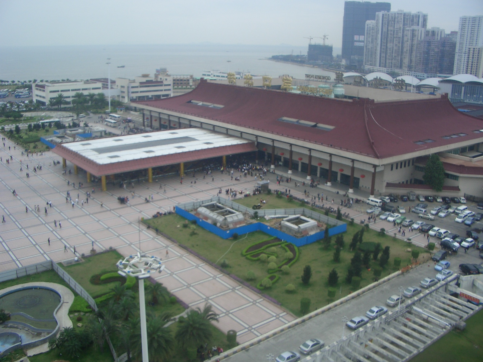
http://www.onlinechinatours.com/uploads/city/city201104265e487.jpg | | | | Do not enlarge it yet, so we can get a better overview. Here north is at the top, so adjust what we had seen on the old map. The point at Barra Hill is now correctly in the southwest, and the Old Town widens into a V as it reaches its north end. Everything you see on the southeast side is recent landfill. You'd almost think someone was trying to make the V into a W! | | | | Now click to enlarge, and go to the north end, where it's now obvious that it isn't an island any more, and hasn't been for quite some time. At some point early on, the narrow strait at its north end silted up and became a narrow isthmus instead, so that Macau became a peninsula, which it still is (that is, the main area, not the clone). It's attached to Guangdong Province in China, at the city of Zhuhai (pronounce ZH as CH, but we'll get back to that). Three different sources describe the land border as a mere 200, 310, 340 meters/yards long. I did not visit the north end of Macau, which primarily has only the border crossing, so I didn't pace it off myself, but you get the idea. It's short. | | | | When we discussed left- and right-hand traffic (2013/15), we mentioned the two crossings in Macau where traffic had to change sides, the Lotus Bridge (down by the Macau clone; we had a picture of its ramps), and this, the older, and principal crossing. It's called in Portuguese the Portas do Cerco, and the name appears in English as the Barrier Gate (or, sounding less defensive, the Border Gate), even though "portas" is plural. I was also curious about "cerco", so I looked it up, and again fell into the romance of language. It means "circle". No surprise there, but no help. It also means "encirclement". Aha. Sounds more military. And finally, more militarily still, it can mean "siege". Got it. The Portas do Cerco are literally the Siege Gate(s)! It does have a nice, defensive flair, literally speaking. Maybe the more defensive-sounding "Barrier Gate" is indeed the better English translation. | | | | There follows an example of researching and learning something after the fact. I had no reason to go all the way up to the northern part of town just to see a border crossing, but I've now found some information with pictures, so let's all find out together. | | | | There actually is (was) a physical gate—singular—built in 1849 (Photo by Alanmak). It now appears to be converted into a fountain facing the modern crossing on the right. Given the hordes of Chinese crossing into Macau to visit and to gamble, it's no surprise that in 2004, the new frontier crossing (Photo by Slleong) was built adjacent. This is an overview (Photo by 9old9) of the crossing, where the old gate seems quaintly lost. It seems that pedestrians come and go on the roofed pathways. You can tell it's Macau because of the left-hand pedestrian and road traffic to and from the immigration and customs checkpoint. Note the buildings on the Zhuhai side, including the maroon Chinese-style roof. That's the Gongbei "gate" (Photo by 9old9) for customs and immigration on the China side in Zhuhai's Gongbei neighborhood. Note the right-hand traffic here. A new rail station (2012) of the Guangzhou-Zhuhai Intercity Railway with high-speed service to Guangzhou is apparently located beside the crossing. | | | | OK, back on topic. Go back to the Macau map. You'll note that some land reclamation started as early as the 1600's and that much of the strait to the north is gone, and Ilha Verde is no longer an independent island, but a Macau neighborhood. This foresaw the modern land reclamation for the casinos at the other end of Macau. Go down the east side to Guia Hill, which is no longer on the coast, due to all the landfill here. Note the two newer boulevards going west toward the Old Town, one coming from the ferry terminal and ending at the Casino Lisboa and the other under Guia Hill ending at the Grand Lisboa. There are many hotels in this area, most with casinos. Note in particular to the south the Wynn and the MGM, and closer to the ferry, the Sands. All this we'll get to shortly. | | | | Now let's enter the much more interesting Old Town. From the Grand Lisboa, walk up to Senado Square and Saint Dominic's Church, then uphill to the Ruins of Saint Paul's. Walk back to the square and take Rua Central, as it changes its name twice, to other sights including Lilau Square, ending at Barra Hill and the A-Ma Temple. You now have a preview of what we'll be visiting shortly on the Macau Peninsula. | | | | Macau is small. I am told that the longest axis on the peninsula runs 4 km (2.5 mi) from the Portas do Cerco to Barra Hill. I walked about half of that, plus also briefly visiting six casinos. It was all in the intense heat that plagued me for much of the China trip, but made for a very memorable day nevertheless. | | | | Do you think you have a preliminary idea of how we'll shortly be visiting Macau? I think you do. But how about the other "Macau"? Where could it be? Let's first look at a map that's just about a decade out of date, which is old enough to demonstrate something very interesting. The map's mostly in Cantonese, but that shouldn't slow us down. It shows that over the centuries there had been two separate islands south of the peninsula, Taipa and Coloane. There is no doubt in my mind that each of them had already been beefed up over the years with landfill, just as the airport was built out in the water, but that isn't the point. The entire area between Taipa and Coloane has now been filled in, and the reclaimed land plus the two previous islands results in one huge island. The area that was filled in has been named Cotai, or the Cotai Strip, a name derived from the islands' names Co[loane] and Tai[pa]. Cotai is pronounced like "coat ['n'] tie" without the middle word. This is how the Cotai Strip fits into the map today. To the eye, the combined complex seems larger than the entire Macau peninsula. Thus, I say, Macau has cloned itself. | | | | The airport still sits by itself to the side, down here, and not directly up at the peninsula. There is now a second ferry terminal here linking directly to Hong Kong. We'll discuss the three bridges that have connected what I like to call the two Macaus. And look carefully, and you'll notice that the Lotus Bridge, the newer crossing from China, with all those ramps to switch between right- and left-hand traffic, ties in directly to the Cotai Strip and not to the peninsula. It's a whole new world. I accept it, but I'm not enthusiastic about so much resort and casino space taking over, as it were, but so be it. | | | | In addition to local casino influence, we've already seen the international casino influence on the peninsula, including the very powerful Las Vegas Sands Corporation with its Sands Hotel near the ferry. That organization was a prime mover in the Cotai Strip, and they were the ones who coined the name, and then patented it with the US Patent and Trademark Office. However, most people use the term casually to refer to the entire strip, and perhaps indirectly, to the whole composite island, although Taipa is still frequently used. | | | | Construction on the Cotai Strip began in 2002 and the first Cotai casino opened in 2006. The Las Vegas Sands Corporation then built its anchor property in Cotai, the Venetian Macao [sic], which opened in 2007. It's modeled after its sister hotel, the Venetian in Las Vegas (to me, it looks like a larger copy of it), except that this Venetian is not only the largest and most notable property on Cotai, it's also the largest casino in the world. Steve Wynn has acquired a property near the airport, so he'll eventually end up with a Wynn Cotai as well as his Wynn Macau (better spelling). We'll continue with this discussion as part of our visit. | | | | But first, a recap. In 2007/16, on my visit to, and report on, Las Vegas, I pointed out that Macau had overtaken Las Vegas as the world's gambling center. I said, in part: | | | | | | The New York Times reports that the Hong Kong billionaire Stanley Ho had had a forty-year monopoly in Macau, and nothing much changed. With Macau now reverted to China, Ho’s monopoly ended in 2002 and other hotel-casinos are coming in. In his behalf, it should be said that Ho has brought in a new hydrofoil that cuts the Macau-Hong Kong crossing from 4.5 hours to 50 minutes. A growing Macau last year passed the Las Vegas Strip as the world’s gambling center. In 1999, Macau had 7 million visitors; in 2006 it was up to 22 million. From out of Las Vegas, Sands, Wynn and MGM are aggressively building casinos and resorts in Macau. Macau has the only gambling in China, whose people are known for enjoying gambling. We shall see. |
| | | | The Casino Lisboa and Grand Lisboa belong to Stanley Ho, and date from the earlier era. His monopoly ended in 2002, which is when the international casinos came in. I rode the hydrofoil, being aware at the time that it was Ho's achievement. In addition to the two Ho casinos, I visited the three I'd mentioned, the Sands, Wynn and MGM, plus the Sands's Cotai presence, the Venetian. In 2007, I had no idea I'd ever actually visit Macau when I said "we shall see", but now I'm pleased to be able to say that "I have seen". We all will in a moment. I just want to add that Sheldon Adelson, the billionaire chairman of the Las Vegas Sands Corporation, has said that his company will soon be a mainly Chinese enterprise, and quipped that Las Vegas should now be called "America's Macau". | | | | It's an odd coincidence that the word "strip" should apply to both locations. As explained in 2007/16, in early Las Vegas, gambling had been primarily downtown, but drivers coming up from California found it cheaper to stay in motels on the highway just outside of town to the south. This strip of motels on Las Vegas Boulevard eventually became the Las Vegas Strip, and has long since outshone the downtown casinos. Now in Macau, the Cotai Strip also uses that word. Curious. | | | | The Visit to Macau I had seen what I'd wanted to see in my first 3 ½ days in Hong Kong, and put Day 4, a Saturday, aside for Macau. The day before, I had discussed what I was going to do with the concierge at the Sheraton, and his comment was that things would be busier since it was a Saturday, something I hadn't considered, since I tend to be oblivious to the calendar when traveling. The bottom line is that, the day worked out perfectly (other than the heat), and there was no cause for concern, and Saturday night crowds at the casino lent to the atmosphere. | | | | The Ferry I had a nice breakfast at the Sheraton, and didn't rush. I made my connections on the MTR to arrive in three stops at the Sheung Wan station, connected to the Macau ferry. I had an immediate indication why the MTR makes so much money. It invests in real estate around its principal stations, and when I took the escalators up from the station, I found myself in a shopping mall joining the station with the ferry terminal, but finally found the ticketing area. | | | | Knowing that the high-speed jetfoil ferries run by TurboJet left every 15 minutes day and night and took just under an hour, I naïvely figured I'd walk up and buy my round-trip ticket for the next boat and return whenever I was ready. Silly me. | | | | The modern, comfortable ticketing area was a combined circus and zoo. That there might have been more pedestrian traffic on a Saturday wasn't really an issue. Some windows were selling helicopter tickets for Macau, others were taking future reservations, others were selling expensive super-class tickets. I finally figured out what an economy class round-trip ticket should come to, and asked for one. The lady was charming, but still, details of how things worked weren't made clear. She asked me what time I wanted to go. It was 9:48, and I thought 10:00 would be nice. HA! The next available ticket was for 11:15. But in this organized chaos, I soon learned not to believe that number. | | | | I'd expected to come back in the early evening, but seeing how things were working, I asked for one later than what I wanted, and she gave me 9:15 PM. I was now sure my day was in disarray. Since I had time before my ticketed departure, I at first wondered if I should walk around and kill time, but fortunately I decided to go inside right away. First I quickly went through Hong Kong passport control for exiting, and then went to the dock area. I asked an official about where to wait for the 11:15 boat, and he suggested I get into the long standby line. This was something no one had explained. If you'd consider that they might be able to accommodate just a handful of standbys on an otherwise sold-out ferry, you'd be just as wrong as I was. Apparently they don't sell out the ferries in the first place. | | | | The stupid thing about the system was that you could consider the printed times on the tickets something of a fiction. The beginning of the standby line got on the 10:15 boat, and I got on the 10:30 boat. 11:15 indeed. Apparently they sell a large batch of timed tickets for each sailing, then allow a HUGE standby group on. I felt that, instead of gambling in Macau, I'd instead played the "ferry lottery" as to which crossings I'd be taking. It was the same thing coming back. On arrival in the evening, I got on the 7:45 boat, my 9:15 return ticket notwithstanding. What a crazy system. But it all went well. | | | | There was numbered seating on the ferry, and I was in the large center section. We'd soon crossed the estuary and were at the Macau Ferry Terminal. I now had to go through Macau passport control to enter, and had a pleasant surprise. There were many windows, some for people from Hong Kong, from Macau, from China, plus a lot of windows for visitors, all busy. Then I found something I've never seen before. One window for visitors was labeled age 65+, and no one was there. I breezed through, and the same thing on the way home. Nice. | | | | This is a sign in the ferry terminal (Photo by Alan Mak). Portuguese and Cantonese are the two official languages of Macau. English, though NOT official, is everywhere. Oddly, this sign also had Japanese. Other signs also led to the shuttles outside the terminal. | | | | Free Shuttle Buses I had read in advance that all casinos have free shuttle buses waiting at the ferry terminal, also at Portas do Cerco, and at the airport. They don't want to miss a beat. It was my full intention to work the system in my favor and get all I could out of the shuttle bus system, and my three shuttle-bus plans for the day fell into place perfectly. | | | | I had naïvely pictured there'd be some dispatcher there that would, on occasion, point the way to the odd casino bus that would casually amble by, trolling for visitors. Silly me, again. This was Macau, and this was business. Facing me outside the doors to the terminal was a line, side-by-side, of perhaps two dozen uniformed agents, each with a sign on a pole for his or her casino. In no way were they aggressive, so don't get the wrong idea. I just went up to the one I wanted, and she told me how to get across the parking lot to the buses. Once there, I could have been in a bus station. Angle-parked along a long curb, each with another agent with a sign, were the shuttles, just waiting. What service. What fun playing the system. | | | | Gambling in Macau Gambling, which many casinos now like to call gaming, has been legal in Macau since the 1850's, when Portugal legalized it. For most of its history, only Chinese games were played, the most popular one being Fan-Tan, also Pai Gow. Both are still played in Macau, but in a switch, are also played now in Las Vegas and elsewhere internationally. It wasn't until the 20C that western-style casino games were introduced to Macau, a more recent one being craps. While I was in Macau, some casinos were advertising they now have Texas Hold 'Em. All these things quickly become so international. We've already documented how Stanley Ho became involved in expanding Macau gambling with his Casino Lisboa in 1970, and how his monopoly expired and the international casinos came, largely from the US (Las Vegas), but also from Australia and elsewhere on the international stage. According to the online World Casino Directory, today Macau has 39 casinos, 31 on the Peninsula and 8 in Cotai, also described as being in Taipa. I suspect these figures will be increasing, especially in Cotai. Gambling tourism is now Macau's biggest source of revenue, making up about 50% of the economy. The visitors are very largely Chinese nationals from the mainland and from Hong Kong, which was apparent to me in the casinos and on the streets. | | | | Lisboa & Grand Lisboa My preference would have been to visit (1) the 0ld Town first, then (2) the two local casinos I had selected, the older ones of Stanley Ho's, the Lisboa ("Lisbon") and the Grand Lisboa, and (3) finally, four of the newer international casinos I'd hand-picked because of name recognition from Las Vegas. But this was impractical if I wanted to make proper use of the free shuttles, since I had to start with one. Because the local casinos were in the center, near the Old Town, the visiting order became (1) local casinos, (2) Old Town, (3) international casinos. Therefore, I boarded the shuttle for the Casino Lisboa. | | | | Go back to the map of the Macau peninsula (link above) that we're holding in a separate window. Click on the ferry terminal to the right, and let's all board the happily air-conditioned free shuttle bus as it drives down the tree-lined boulevard, the Avenida de Amizade (Amity Avenue, or Friendship Avenue) on our short trip of 5-6 minutes. On our left we'll pass the Sands (we drive on the left, remember), later the Wynn with the MGM behind it, then make a sweeping U-turn to the Casino Lisboa, with the Grand Lisboa across the next boulevard. | | | | It is in no way my intention to critique casinos or hotels. After using the shuttle they kindly supplied us to get to the center of town, we're only stopping for a walk-through of a few minutes, ten tops, to get a feel for these casinos, nothing more. The Casino Lisboa complex (Photo by WiNG) dates from 1970. (Off the picture to the right is the Wynn, and off to the left is the Grand Lisboa.) The main building is in the center, and was added onto over time. It is not quite to my taste, and reminded me the moment I saw it of a cross between a gaudy wedding cake and a stack of vinyl records waiting to be played on a juke box. But it's the building that started the new casino wave. Its gaming floor was so-so, its lobby was attractive, but I'll always remember what I saw in the lobby as soon as I entered. Hanging on the wall, almost full-size, but in ceramic, not in stone, was a reproduction of a Nine-Dragon Wall (2013/18). It's an attractive image that still remains with me. | | | | Since the Grand Lisboa was affiliated with the Lisboa, there was an escalator down to an underground passage across the next boulevard over to it. Thus, I first saw this hotel's interior. Its lobby (Photo by WiNG), which was a wonder of art work. There were showcases of jade statues, giant ivory carvings, and a life-sized peacock in a glass case made with articulated parts. It was very impressive. It was only then that I stepped outside to look at the exterior of the Grand Lisboa. I found myself craning far enough backward that I had to hold on to a traffic-sign post so as not to fall over. Why? This is what the Grand Lisboa (Photo by WiNG) looks like from the outside. | | | | My first impression was that of a decorative perfume bottle, with that domed roof to the spherical lobby as the flask and the hotel above as the flamboyant neck to the bottle. Look how it lords over the wedding cake of the Lisboa. The Grand Lisboa, with 58 floors, is the tallest building in Macau. It dates from 2007/8 and is obviously Stanley Ho's answer to the 2006 Wynn Macau across the street, to Adelson, and to the others he must consider upstarts. | | | | I stopped gawking upward so I could let go of the post without falling over, resigned myself to be out in the heat again, and was pleased to note that the avenue I was on was the Avenida do Infante D.[om] Enrique. Do you recognize the name? | | | | We last saw his name last year in the Azores, in Angra on Terceira, where I had a whole section on him. O Infante Dom Enrique is known in English as Prince Henry the Navigator, whose name will be found everywhere in Portugal, and, apparently, in Macau as well. Review, if you wish, the writeup about him in 2012/7. | | | | After an intersection, the street became Avenida de Almeida Ribeiro (Photo by 9old9), the principal commercial avenue of the Old Town, with typical large stone buildings with arcades to get away from the sun in. It was just steps to Senado Square (see map). | | | | In 2005, 25 buildings and locations in the Old Town were inscribed on the UNESCO World Heritage List under the title "Historic Centre of Macau". All the sites are well marked on maps, and the buildings have free entry. Some less interesting ones were well away from the walking route I'd planned; others were along the route, and I noted them in passing. I'll be mentioning the ones that most interested me, which were quite a few, and principal among them are these next two. Actually, the first part of the walking tour started here and went north, the second part, south. | | | | Leal Senado & Senado Square Under Portuguese rule, the legislature was the Senado (Senate), but its full name was peculiar. It was called the Leal Senado (Loyal Senate), and is still referred to that way. Macau had remained loyal to Portugal during an earlier troubled event, and the title was bestowed by Portugal on the senate in 1810, and has since remained part of its name. This is the building of the Leal Senado (Photo by Netsonfong), which was erected in 1784 and is now used for other purposes, including a contemporary art museum. We are here standing facing it in Senado Square, or Largo do Senado, the most famous location in Macau. We've just come walking from the left up that main street, Almeida Ribera, where those cars are (click) between the building and square. The typical swirled Portuguese sidewalk tile (Photo by The Red Hat of Pat Ferrick) was in that street and covers the entire square, which continues as a triangle whose apex well behind us and whose base is the Leal Senado before us. My first memory of arriving here, though, was sitting down with those people in the shade of that blessed tree on the left, to catch my breath and cool off. A pleasant memory. | | | | I then went across the street and entered the lobby, which had a staircase up to a pleasant patio. On an arch above the staircase is the sign proclaiming loyalty (click to see the word "LEAL" on the right). Notice the profusion of the typical blue-and-white Portuguese tiles called azulejos. | | | | Leaving the Leal Senado we look across the street at the colorful buildings of Senado Square up toward its triangular apex. Between the pink and gold buildings we can visit the small temple Sam Kai Vui Kun, which dates possibly from the 18C and was built by Chinese merchants, and see its coiled incense. Also note the white building on the right of this picture. It's the Santa Casa da Misericórdia (Photo by Андрей Суриков / Andrey Surikov), or Holy House of Mercy, built in 1569 as a medical clinic and was later an orphanage and refuge for widow of sailors lost at sea. Locations like these two are typical of the Chinese-Portuguese cultural blend found in Macau. | | | | But our quest to get to the other icon of Macau, the Ruins of Saint Paul's, brings us all the way up to the apex of the square (Photo by Jpatokal), where we can already see the hill we'll need to climb. But first, let's look at a short (1:06) YouTube video of Senado Square. And no, it's not raining. Lots of people, both men and women, use umbrellas as parasols in the intense sunlight. | | | | At the apex, we do three things. We turn right into a narrow side street to visit the Lou Kau Mansion, an attached town house built in 1889 for a wealthy Chinese merchant and gambling tycoon. It's a stone building, unfurnished, composed symmetrically of two traditional Chinese courtyards separating three main halls. Western influence is seen in neo-classical balustrades and wooden ceilings similar to those found in many of Macau's churches. | | | | If we then backtrack a few steps to the apex and turn left, we come across St Dominic's Church (Photo by Whhalbert), or Igreja de São Domingos, in Baroque style, the oldest in Macau, completed in 1587, although due to renovations and reconstruction, the current building dates to the early 17C. | | | | We continue just beyond St Dominic's and follow signs—and the pedestrian flow--to the commercial pedestrian street that goes uphill some three blocks to the ruins. This is just how it looks, the shops, the pavement, the almost exclusively Asian faces. But there are surprises. A large number of shops are selling pressed, sliced sheets of spiced jerky made from beef, pork, mutton, or blends. And they're giving samples. How odd to keep on tasting different varieties of jerky while walking along. Other locations were giving out samples of small almond cookies. What a pleasant way to try to forget the heat. The narrow street finally opens to the staircase leading up to the ruins. | | | | | | The wonders of serendipity! Later research shows that this jerky seems to be a Chinese specialty called bakkwa (Photo by 嘟嘟嘟), as shown in this display in Hong Kong. Click to read the varieties.
Additional research shows that, not only are almond cookies—also known as almond biscuits in the British world--a standard specialty of the Cantonese area and heavily exported, most that arrive overseas are from Macau. (!!!) They are described as small, dry, and crunchy, to the extent that they may disintegrate on the first bite. (I agree.) I read now, after the fact, that they are a popular Macanese specialty product, particularly in the streets leading up to St Paul's (!!!), where there are 10-20 shops vying with each other, each with hawkers on the street giving samples. (Yup.) The most famous Macau almond cookie is apparently made by Koi Kei (Photo by Mo707). I wonder if I sampled one of theirs?
|
| | | | St Paul's Ruins It started in the heyday of Macau when business was good and cash flowed freely, and the Jesuits decided to build a cathedral on top of a hill, reached by stairs. Construction started in 1582 and the building was completed after two decades, in 1602. The cathedral of Saint Paul was one of the largest Catholic churches in Asia at the time. But during a typhoon in 1835, a fire destroyed most of it, leaving only the façade and the below-ground crypts. By this time Hong Kong had been established and was drawing business away from Macau, which was no longer the main port of the Pearl River Estuary. This resulted in seriously decreased funding, so that Saint Paul's was never rebuilt. Thus the ruins reflect the ebb and flow of local history. This is an illustration dated 1854 of the Ruins of Saint Paul's, or Ruinas de São Paulo by German-American artist Wilhelm Heine. | | | | In recent decades the remaining southern wall started to lean dangerously, and there were calls for demolition, and so from 1990 to 1995, the Macanese government acted. The ruins were excavated, the crypt and foundations were uncovered, and the wall was stabilized, turning the complex into a museum. The stone façade, intricately carved between 1620 and 1627, is now supported by concrete and steel from the back, maintaining its artistic integrity from the front. There are 66 stone steps coming up the hill to the façade. I've read, although I did not find any in the blazing sun, that there are carvings blending Jesuit images with Asian themes, such as one of a woman stepping on a seven-headed hydra described in Chinese characters as "Holy Mother tramples the heads of the dragon". Today the ruins are one of the icons of Macau, and part of the UNESCO World Heritage Site. | | | | And so we exit the shaded approach street and climb the 66 steps in the sun up to the façade of St Paul's (Photo by Whhalbert). Click to inspect the carvings. We find on passing through the entry that it's a strange feeling still being outdoors when reaching the other side. Once on the "inside", we can look back to the steel and concrete buttressing (Photo by Mo707), although the viewing platform is no longer open to the public. The glass cases show foundations, and in the back, two stairways lead down to the crypt, with other glass cases exhibiting bones. The crypt is mercifully air conditioned. | | | | On exiting the façade again, we turn right around the foundation to go see the tiny Na Tcha Temple (Photo by Minghong) with its coils of burning incense. It's not that it's so unusual, but the juxtaposition of temple and ex-cathedral is worth seeing, and as a bonus, the temple is next to a small remainder of the Macau city wall, complete with gateway. | | | | The city wall of Old Macau remains today only in sections, but it surrounded Macau in the 16C and 17C, as we saw on the very first map of Macau as an island. The wall was started in 1569, and defended against Chinese invaders and others, including the Dutch. It was unusual in that it was built of clay, sand, rice straw, rocks, and oyster shells. But it was not properly maintained, and slowly collapsed over time. This next picture is unusual in that it shows three of the 25 sites in the UNESCO designation, the wall, pagoda, and ruins. | | | | It's now time to walk back to the façade once more and, with the tower of the Grand Lisboa looming on the left, look down (Photo by edwin.11) to the narrow pedestrian street we had come up. On the way back to Senado Square to do the second part of the walk, we can sample more jerky and almond cookies. | | | | One more piece of luck. This YouTube video shows in 3:40 the very walk we just took from the square to the ruins. Pause at 2:02 to inspect the folded slabs of jerky, then, fleetingly, the almond cookies. | | | | Back at Senado Square, we can begin the second part of the walking tour. Look at the Macau map again. Review where we just walked north of here, and now we'll walk south. Rua Central (Central Street) is at the corner, and we'll take that all the way to Barra Hill, even as the street changes its name twice. While no one makes a point that this is the street to take, the name alone implies that it was, at least once, a major street and it does connect several sights. After the back alleys and pedestrian streets we just visited, it's wide enough for two cars to pass, but not much wider. | | | | The change of pace is palpable. Before there were crowds everywhere, both locals and visitors. On Rua Central, we're almost alone. It's a normal, real Macanese neighborhood, with locals going about daily routines. Even though there are sights here, we're off the "tourist beat". We pass a church here and there (see map)—remember there are 25 sights in the UNESCO historic district in all—but mostly we continue on. The two principal sights are the Mandarin's House halfway and the A-Ma Temple down at the end, at Barra Hill, and Barra Square. I find I need a bottle of water and stop at a local, quaint convenience store streetside. A while later, I want a second, and check my change to find that the first woman had included two pataca coins in the change she'd given me, which I then pass off on the second purchase. I find a bench to drink my water and recover a bit. We find one of the typical directional signs (Photo by Destron Commander) for visitors that are all over town, and confirm we're going in the right direction. | | | | Mandarin's House & Lilau Square I reach a tiny cross street and see the Mandarin's House to the right of the intersection, but am surprised to see the charming Lilau Square (Largo do Lilau) to the left, which at first I take to be a personal discovery of mine in my time of need of an oasis, but then realize it's one of the 25 sights (see map). I cross over left to have a seat in "my" Lilau Square (Photo by Netsonfong). This picture I found is the very view of the square as I first found it, and I sat down precisely where those two people are sitting. To me, the time spent under the tree near the kiosk in this charming square remains a pleasant memory, although the square is historic and has its place in the settlement of the area. It's particularly enjoyable to find you're making a contemporary use of a location that was meant for this very use for Macanese centuries ago. | | | | This is another view of Lilau Square (Photo by Elgaard) from the other side of the tree, showing the Portuguese tiles better. Where the people are reading the trilingual history of the square is the crosswalk to the Mandarin's House (Casa do Mandarim) on the left.
| | | | The Mandarin's house (not named on map) is another Chinese mansion, but while the earlier one was a narrow town house, this one ran for at least one very long block on the street facing the square. But like so many buildings one sees—I think of Italy in particular—the street façade is totally nondescript. It could have been a warehouse, for all I new, except for the sign that pointed to the side street, where there was an entrance on the shorter side-street façade to the very long interior courtyard (Photo by Elgaard), the far end of which we're seeing here. When I say the mansion is large, I'd estimate that we're looking at less than half, maybe even a third of the courtyard façade, which looks like a series of townhouses with multiple entrances, but which really are just entrances to different rooms. It's the back of this long structure that faces the main street and Lilau Square. | | | | The facts are these. It's a restored mansion built c 1869 by the Zheng (ZH=CH) family, and restored. It's described as a must-see for those interested in the history of architecture. It's Macau's largest mansion, 4,000 sq m (43,055 sq ft), and has 60 rooms, and a series of inner courtyards. It's apparently a typical, traditional Guangdong residence for the wealthy. It also had at least one circular moon gate. | | | | I ducked into the first entrance in the courtyard to see some special displays, and was happy to have found the only air-conditioned room in the building. They were also in the middle of showing a video on a huge plasma TV, so I took the opportunity to sit down on a bench (the only viewer), to learn something, and to cool off. | | | | But the narration was in Cantonese. Not to worry, I'll read the subtitles. The subtitles were in Portuguese. This was not the negative shock it might have been to some, because I revel in the idea that a bilingual area doesn't necessarily accommodate English. Beyond that, I had a language experience that, forgive me, pleased me no end. | | | | German, French, and Spanish are my main second languages. I have far less ability in five others, including Portuguese. I'd understand very little of what someone speaking rapid Portuguese says, although I can read Portuguese text and get along quite well. But subtitles? You know how fast they change. But the pleasant thing that worked out was that the rapidly moving Portuguese subtitles were backed up by the visuals in the video, so if they said "janela" and they were showing a window, it reminded me that that's what the word meant. I was delighted that I followed maybe 80% of the rapidly moving Portuguese text due to the visual assistance. I still remember that it pointed out that the mansion was really two buildings, it told about the two floors with courtyards, and it explained that, when it was built a century ago, it followed the rules of feng shui, so that it was located where there were mountains behind it and water in front. But now, the buildings across the street block the water view (check map). | | | | I wandered the courtyards and rooms, both upstairs and downstairs, but when there's that many of them, they begin to look alike after a while. I saw what was obviously an exit sign, but your bilingual choices were only "Saída" and "出口"! Memorable though, was one sign that was in English, which was actually in Chinglish, but, as ever, fully understandable: | | | | | | ● On a staircase, a sign said: "To protect the heritage, please make your footsteps softly when going up and down the stairs." |
| | | | After a second stop under my tree in Lilau Square, I continued down the road. Another unexpected surprise awaited me, the Moorish Barracks (Photo by Netsonfong). Its style and color were so different from anything else in town. Note also the modest width of the street, and that it's just local people there, like this guy coming to get his bike. Anyway, the building refers back to the fact that the Portuguese Empire consisted of small bits and pieces, but was quite unified. At one point, when Macau needed military assistance, troops from Goa were sent, and this building was put up to house them. "Moorish", which refers to Morocco, not India, only describes the architectural style. | | | | A-Ma Temple & Barra Square It was only a little further to Barra Hill, at the southern point of the V of the town. The hill was to my left, with A-Ma Temple on its slope. Barra Square was in front of me, and to my right, the strait separating Macau from Mainland China (see map). Barra Square was rather large, and tree shaded, with tables and chairs. I saw more people here than I'd seen on the entire walk since Senado Square. Here, I was in the middle of the oldest history in Macau, which we'll also show is the source of its Western name. | | | | This is the reverse view (Photo by Santosdo) of the entrance we just made, coming out of our narrow street to the left to the oasis of the tree-shaded square. This is the main entrance, guarded by Chinese Imperial Guardian Lions, to A-Ma Temple, with the typical UNESCO marker for the WHS (click). This is the full view of A-Ma Temple (Photo by WiNG), also showing the Portuguese tile on the expansive Barra Square (the treed area is to the left), the square main entrance to the temple, the round entrance to one of its buildings, and Barra Hill, with additional chapels on paths up its side (click). As always, umbrellas are used as parasols by men and women. | | | | A-Ma Temple is the oldest in Macau, and dates from 1488, well before the Portuguese arrival. It's Daoist (old spelling: Taoist) and is dedicated to the goddess of seafarers and fishermen, Mazu (old spelling: Matsu, and it's still pronounced that way). Mazu is widely worshipped in the southeastern coastal regions of China, including adjacent Guangdong province. However, it's unclear to me why the name Mazu appears in the name of the temple as A-Ma. | | | | Above the temple entrance (Photo by Cheong Hei Chon Francisco)—note the lions again—is a ship, a common theme carried throughout, given Mazu's nautical connection. On the right you can see the stone staircase leading to further shrines up the hill. An interior view shows the now familiar incense coils (Photo by Santosdo). The neighboring building (Photo by AlexHe34) continues the ship motif on its roof. Walking up the hill (Photo by deror_avi) not only continues to show more representations of boats, it shows the size of the tiled square as it stretches over to the dock area (click) and the strait separating Macau from China, whose hills are visible. | | | | | | ● There was a sample of Chinglish on a building in the A-Ma Temple complex: "No smoke". Well, if you don't want people smoking, it's because you want "no smoke" in the area, isn't that right? This is particularly amusing, given the quantity of incense clouding the air. |
| | | | It was then time for a break, since we had finished the entire walk in the Old Town, although we still had the international casinos to see. There was an ice cream vendor quoting prices in both HK dollars and Chinese yuan. I got an ice cream sandwich to help with the heat, sat down at a table under a tree, and contemplated several things. To my left was the oldest temple in town. To my right, across the strait, I could see China. Below me was Barra Square, which used to be a bay extending up to the temple, and it's where the Portuguese first met the Chinese, resulting in Macau being named (see below). And I can't remove the final image in my mind that, in front of me, some dozen Chinese teenage boys were performing an extended break dance. That's internationalism for you. | | | | Naming Macau We're sitting in the oldest inhabited part of Macau. The Chinese were here first, as the temple dates from 1488. Although Macau became a Portuguese colony as late as 1557, the earliest Portuguese arrived a half century earlier, in the early 1550's, so when they arrived, the Chinese—and the temple—were already there. It turns out it was the name of the temple that developed in to the name of Macau. Just how that happened, though, is not totally clear. The Portuguese sailors pulled into the bay that is now Barra Square, and asked at the temple what the name of the place was. Just what they were told is here the question. Usually, I present what seems to me a viable solution when something like this arises, but this time, let's look at the available online information together. We'll start with the solution that I feel is to some extent the weaker one, although whatever is correct, Macau is named after this temple. | | | | We already have some confusion about the forms Mazu and A-Ma referring to the same deity, and apparently, the Mandarin version would have been Mage. But they didn't speak Mandarin here, they spoke Cantonese, so the name the sailors would have been told would have been Maa Gok in Cantonese. I have also seen this spelled Ma Kok. Any one of these forms of Mazu could have been interpreted by the Portuguese as something that developed into Macau. | | | | Alternatively, several sources report that an additional word was included, one that meant "bay", which Barra Square had been. Even the historical marker on the square said that the sailors were told something like A-Ma-Cao (the spelling on the marker), which supposedly meant A-Ma-Bay, so A-Ma-Cao would have shortened into Macau. That sounds reasonable, but it's too sleek. "Cao" is not pinyin, nor the equivalent romanization system for Cantonese, jyutping. The Online Etymological Dictionary claims the second element is ngao, meaning "bay, port". But how do we put together all these variations? | | | | I'd like to speculate on this explanation, and it all goes back to an old friend of ours, 口, the character that means "mouth, hole, opening", and that appears in the exit sign (above). Maps we've seen in this posting show that the Pearl River Estuary is written as 珠江口, which transferred into pinyin is Zhujiang Kou. This indicates that 口, meaning an opening or a mouth, can also refer to an estuary, which is a river's opening, or mouth. 口 is read as "kou", pronounced KO, and, although the bulk of the estuary is on the other side of Macau, this strait is a branch of it. I'm going to speculate that what the Chinese said to the Portuguese in the early 1500's as to where they were was something like A-Ma-Kou, or A-Ma Bay, and A-Ma-Kou lost its first syllable and became Macau. Choose the version of the above that you prefer, but you've got to marvel that even the name Macau is a Chinese-Portuguese composite. | | | | Endonym vs Exonym Before we continue our Macau walk, while we're still talking about names, we need to refer again to local names vs foreign names, or endonyms vs exonyms. If you don't recall the discussion, refer back to 2009/33, "Internal Place Names", where, it's pointed out that, for instance, outsiders say Finland, an exonym, but Finns say Suomi, the endonym. The six names of Germany are also given. | | | | As it turns out "Macau" is an exonym, used internationally. It isn't used locally. The endonym appears in Mandarin (pinyin) as "Aomen" and in Cantonese (jyutping) as "Ou Mun", and translates as "Inlet Gates". | | | | Let's also look at two other names. We said that "Hong Kong" is "Fragrant Harbor", and the English name is used as the official one. In Cantonese (jyutping) it appears as Hoeng gong, which is almost the same. Of course, the English is derived from the Cantonese name. Now the Mandarin name, in pinyin, is Xianggang (X=SH). Perhaps we can even try writing it in two words, Xiang gang. It's really the same thing as the Cantonese and the English, and all three are variations on a theme. It's hard to decide between endonyms and exonyms here, so I won't. | | | | But as we discussed in 2009/33, "China" is without a doubt an exonym, as is its variation, "Cathay". At the time, I wrote that the name of the country is written 中国 in simplified Chinese and 中國 in traditional Chinese, and commented: | | | | | | In pinyin it’s Zhōngguó (ZH=CH) and in Wade-Giles it was Chung¹-kuo². We already know that first character, which in Mandarin is zhōng, as representing the concept of “middle”, which can logically also be “central”. The second character, guó, . . . means “country”. So China, or Zhōngguó, is the Central Country, which, given it’s location in Asia and its cultural influence on all the countries around it, is a logical name. It is also rendered in English as Middle Kingdom, but that seems too poetic a name to be of practical use. |
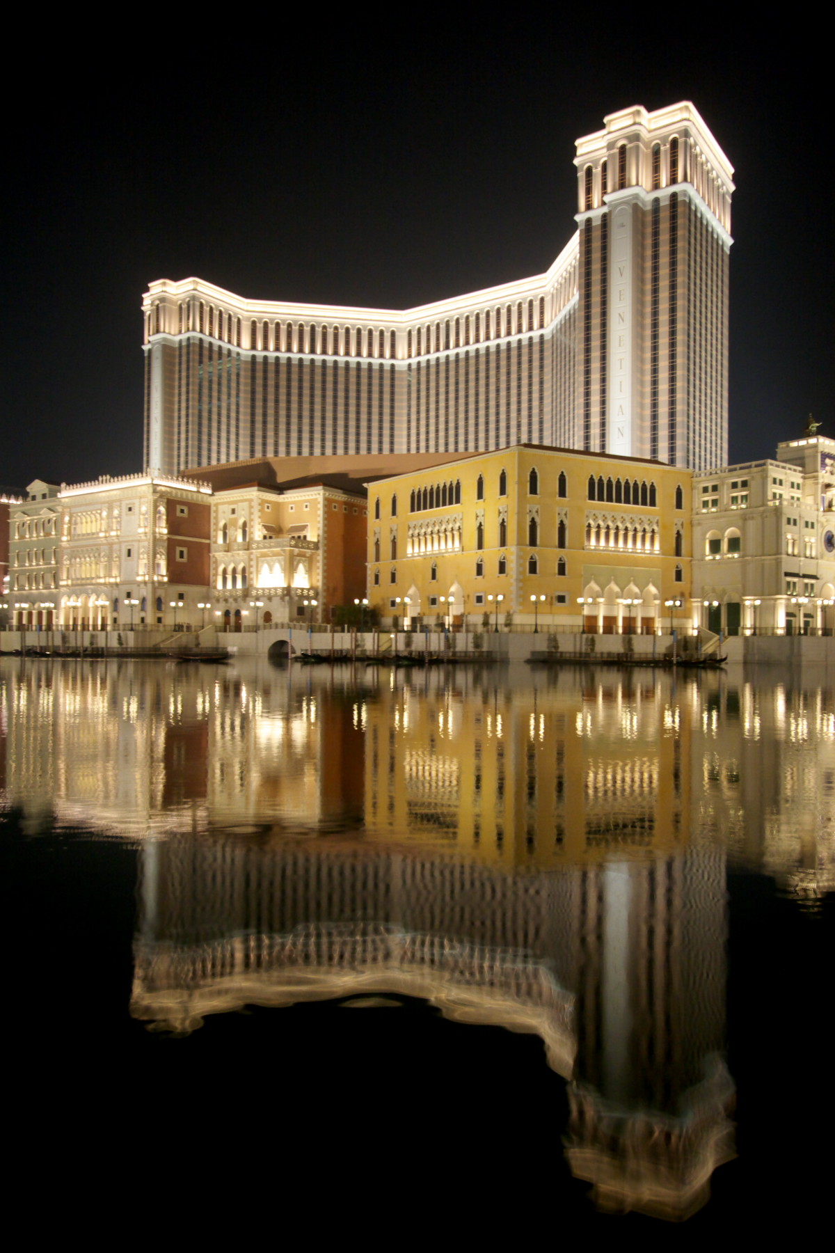
| | | | The International Casinos We finish our ice cream sandwich as the breakdance ends and return to our street, to start backtracking. We pass the Moorish Barracks again, but stop to sit for a third time in Lilau Square, a farewell visit. A bit beyond that, we cut to the right down a side street (see map) and leave this area, cut across some modern, sleek local hotels past the Grand Lisboa and Lisboa, and cross to the area of the international casinos. Again, we'll only spend a few fleeting minutes in each of three on the peninsula and one in Cotai, with names that are recognizable from Las Vegas. | | | | Wynn, MGM, Sands We cross the boulevard from Casino Lisboa and arrive at Steve Wynn's hotel, resort, and casino, Wynn Macau (Photo by WiNG). Note the MGM peeking out from behind it at the right. The Wynn opened in 2006 and claims to be the first Las Vegas-style integrated resort in Asia. | | | | My only casino comments other than how much I liked the lobby of the Grand Lisboa and the Nine-Dragon-Wall ceramic in the Lisboa are reserved for the Wynn, whose interior appealed to me immediately. Most casinos look like an airplane hangar or a large factory floor, where sewing machines are replaced by roulette tables, with about as much charm. When I entered the casino in the Wynn, I had the feeling of being in someone's home—well, let's say, mansion. The corridor down the center had low fences on both sides, and looking right and left seemed to be looking into a living room where one game was being played, then a sitting room, then the dining room. I stopped in the male toilet (!) to cool off and wash my face and hands and pick up a supply of paper towels I'd still be needing to mop my brow outside, and even that room exuded elegance. The Wynn shows class. | | | | Out the back door and across the street is the MGM Macau (Photo by Mfield), formerly known as the MGM Grand Macau. It was OK. Its ownership is interesting. It was built in 2007 under a sub-concession approved by the Macau government, and is owned as a 50-50 joint venture between MGM Resorts International and Pansy Ho, daughter of casino magnate Stanley Ho, giving new meaning to the phrase "all in the family". | | | | Check our map again. We now zig-zag diagonally across the landfill neighborhood to the Sands, which is the closest we've been to the ferry terminal since leaving it this morning. Also note on the map that we've effectively walked the width of the Macau peninsula since the A-Ma Temple, and that was already the end of the Old Town walk. | | | | The parallel and perpendicular streets in this landfill neighborhood, named for European cities, seem trite and out of character for Macau. If this area were the entirety of the peninsula, there wouldn't be any urban charm at all. The 2004 Sands Macao [sic] (Photo by Whhalbert) is memorable to me only because you had to take escalators from the lobby to the barnlike casino upstairs, whatever that memory is worth. But at least I'd now had a peek at three well-known names in the casino world. | | | | Actually, the Sands was much more memorable to me because of the mini-bus terminal at its side with its zoo of free shuttle buses, all neatly set up with signs and fenced-in queue areas. Very busy were the shuttles leaving to the Portas do Cerco border crossing into China. Then there was shuttle queue to the nearby ferry terminal, but that was not of interest now. Finally, bingo! I found the third possibility. The free shuttle from the Sands to its sister property, the Venetian on Cotai. I had read about this, and it would complete the day. Playing the system, this would be the second of three free shuttle rides, would get me a tour to and from Taipa/Cotai, and would show me the largest casino in the world. | | | | The air-conditioned bus filled and left promptly. I wondered what route it would take, and both going, then coming back, turned out to give me a complete tour of whatever I hadn't yet seen. Check our map again, because we drove right along the south shore of the peninsula. Later, on the return, we'd cross the longest, eastern bridge (4.4 km, 2.7 mi), but now we'd pass and see the middle one, and then cross over on the western. Note also the location of the Statue of Kun Iam (Guanyin) out in the water. | | | | Guanyin I have to reconstruct this information after the fact. I'd seen the reference to the statue on the map under the name Kun Iam, was vaguely aware that it was there, but hadn't known enough to want to walk over to it. It was therefore a great pleasure to see it when passing in the shuttle bus and to research it now. | | | | Although the map said Kun Iam, we're actually talking about Guanyin, called in English the Goddess of Mercy, and revered across Asia under various names. Further digging shows me that Guanyin is the same figure known in Japan as Kannon (say both names aloud and you may hear a similarity, despite the spelling difference). You may want to refer back to the trip to Japan in 2009, and to the visit in Kyoto (2009/39) to the shrine containing 1,001 statues of Kannon. I am absolutely flabbergasted now that I find out that the Japanese camera manufacturer Canon is named after Kannon/Guanyin. | | | | The statue of Guanyin in Macau (Photo by 9old9) is impressive for its graceful C-shape rendering of the figure. As often happens in Macau, Guanyin here is a blend between the traditional images of Guanyin and the Christian Mary. In typical Asian style, she is emerging from a lotus. The tiny people you see in the picture show that Guanyin is 20 m (65.5 ft) tall, plus the lotus pedestal of 7 m/yds making a total height of 27 m (88 ft). | | | | But it was the name on the map that confused me, since it's called the Kun Iam Statue, which misled me. More digging. It turns out that in Macau, Hong Kong and southern China, in other words, the area where Cantonese is spoken, Guanyin appears as Gwun Yam or Gun Yam. Beyond that—how's this for further refinement--in Hong Kong the variation moves to Kwun Yam, and in Macau as Kun Iam. Et voilà. | | | | Bridges to Taipa/Cotai & the Venetian After the statue, we passed under the middle bridge (Photo by Mo707), which is the oldest, dating from 1974. It is now used only for buses and taxis. Note the MGM, Wynn, and the tower of the Grand Lisboa. This being China, the bridge is supposed to represent the body of a dragon, with the Grand Lisboa being the head, and a monument on the Taipa side the tail. Here's a close-up of the "head and body" (Photo by Diego Delso). What a tower. | | | | We were back near Barra Hill, where we'd just been, when we pulled onto the graceful westernmost bridge (Photo by Mo707), the newest one, built in 2004. By this time, twilight was approaching as we whizzed across to Taipa and Cotai. I've since learned something very interesting about this bridge. Aside from the open top deck we crossed, it has an enclosed lower deck. I now see, that if you look at the bridge and click, you see portholes for the lower deck. There are two very good reasons for having this enclosed deck. One is to accommodate a future light rail line (more below). The other is so that, when a typhoon strikes and all bridges have to be closed for safety purposes, emergency traffic can still get across from one side to the other. | | | | | | This reminds me of the situation when hurricane Sandy struck the New York region (2012/22) and every one of the city's bridges was closed to traffic due to high winds. That was on 29 October 2012, just a year ago, and New York is still trying to recover. |
| | | | As we leave the Macau peninsula, take a look at some maps. First, copy and paste this one into another window:
http://www.doc-dmc-macau.com/admin/files/Macau_City_Center_MAP.jpg
| | | | It should by now be quite familiar, but what pleased me when I found this map after returning home is the pink path shown through the Old Town, from Saint Paul's Ruins (click) via Senado Square to A-Ma Temple. I had selected my own stops north of Senado Square, where many visitors were, but then also south of it, where few others trod. Of the 25 UNESCO locations, others are scattered further afield, but our path, wider in some spots, is the one we took. I'm happy "they agreed" with me! | | | | But we're really here for the continuation of that map southward, so copy and paste this:
http://www.doc-dmc-macau.com/admin/files/MACAU_MAPa.jpg
| | | | This shows both areas in question. Click on Taipa to see its traditional island shape, even though it's no longer an island by itself—same for Coloane at the bottom—but then we have the Cotai Strip connecting them. As the bus was coming down the west side of Taipa, I knew what I wanted to look for, and did manage to see it. I saw ahead the ramps to the Ponte Flor de Lótus (Lotus [Flower] Bridge), the newer border crossing from Zhuhai to the Cotai area of Macau. This map also shows the Macau passport control area on this side of the bridge. | | | | We then pulled into the casino area. Put this main, gray-and-green Cotai map aside until we're ready to leave, because I have another map that shows the casinos in more detail. Cut and paste this "black" map in another window:
http://www.marimari.com/hotel/macau/four_seasons/images/map.jpg
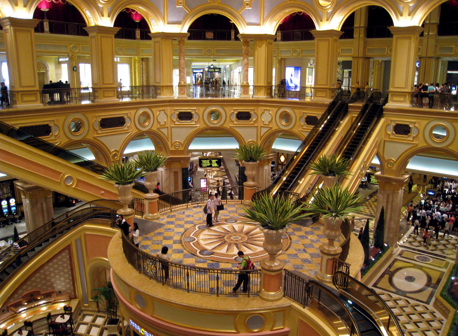
| | | | Once near the casino area, we pulled into the Venetian Macao [sic], at its upper end. It dates to 2007 and is the 40-story, US$2.4 billion anchor for the seven hotels on the Cotai Strip, and is modeled after its sister resort in Las Vegas. It's the sixth-largest building in the world in floor area, the largest casino in the world and the largest single-structure hotel building in Asia. If you want the figures, it's 980,000 sq m (10,500,000 sq ft). | | | | Like the one in Las Vegas, it has all the same kitschy copies of buildings in Venice (do I sound cynical?). From the bus I saw the copies of the Rialto Bridge, Doge's Palace, St Mark's Campanile (Photo by Abasaa). Inside, as in Las Vegas, there's a canal with gondolas, which I didn't even bother to take time to look for—it was more than I needed to see. By this time it was beginning to get dark, so this night picture of the Venetian (Photo by vixyao) is pretty much how I saw it. | | | | Putting aside all those copies of buildings—it's just too Disney World--I do give the Venetian architectural credit for lushness and glitz. This is the entrance lobby (Photo by WiNG), and a little beyond that, this is the Great Hall (Photo by WiNG). This I think is architecturally well done. Beyond that, I went into the casino, which has the charm of an airplane hangar. I think the Venetian is a place to gawk for a bit, but it's just too big. I call it a temple to excess. | | | | Back to the buses. The staging area again has shuttles to the border at Portas do Cerco, back to the Sands, but now also to the new ferry terminal in Taipa (more below) and to the Macau ferry terminal. To give an idea of the volume of people—after all, it was a Saturday night—I joined the queue I needed and got on the third bus to pull up, but it took just about five minutes, that's how fast things were moving. | | | | This third and final shuttle, which was express to the Macau ferry, still zigzagged through the Cotai casino area, so I got a view of a lot of the rest of it. Go back to the black map and look at the casinos. I know I saw from the bus the Galaxy, the Conrad, the Sheraton, and the oddly-named City of Dreams. (I'm cynical? What sort of dreams would a casino be fulfilling, those of people hoping to get rich through gambling? Puh-leez.) | | | | Note that there's also a university here, a sports dome, and other features. You'll also see the area where Wynn Macau got approval in 2012 to build Wynn Cotai. Now go back to the more-complete gray-and-green map and follow our shuttle route northeast past the airport. Note that north of the airport is the new Taipa ferry terminal here, primarily for Cotai gamblers, with service direct to Central in Hong Kong. | | | | We swing around for the bridge, and get a beautiful view in the approaching darkness of the lights of peninsular Macau across the water. Beautiful. Heading directly to the Macau ferry terminal, the easternmost bridge (Photo by WiNG) was the second built, in 1994, and, curiously, has two crests, to allow for the passage of sea traffic. While this is a daytime picture, and I crossed it at night, it was nicely illuminated, adding to the experience. | | | | At the terminal, it was first the Macau passport check to exit, and again, the 65+ line had no one else on it. It was then back to the "ferry lottery". My ticket said 9:15 PM, and it was about 7:20. The first people on the standby line got the 7:30, and I got the 7:45. No problem. In Macau, there was the Macau passport check to enter, then the MTR to the Sheraton for a late dinner. But first, in addition to my usual morning shower, I had to have my now-essential evening shower in order to "come back to life" from the oppressive heat of the day. | | | | It had been a fabulous, memorable day trip to Macau. It was well-planned, and everything fell into place. The entire day in Macau was just over eight hours. Including both ferry trips, it was just over ten hours. I had played the shuttle system and came out ahead. You'll note that, aside from the round-trip ferry ticket, my day trip cost me two bottles of water and an ice-cream sandwich. | | | | Macau Transportation Plans I've found three new transportation initiatives that will improve service to and in Macau. | | | | Connecting Macau by Rail We know that high-speed rail is being extended down into West Kowloon in Hong Kong, so we can mention that proposals have been made to do something similar for Macau. We know that high-speed rail comes up to the border crossing in the north via the Guangzhou-Zhouhai Intercity Railway, but, given the built-up nature of the peninsula, that isn't where any extension might be. Talk is of extending the Guangzhou-Zhuhai Intercity Railway directly to Cotai in the same area that the Lotus Bridge enters Cotai. But nothing has been decided. | | | | Macau Light Rail I had discovered before I left home that Macau was working on a light-rail system. It's presently under construction, and they're planning on opening the first phase in 2015. It will be fully automated, driverless, and run on rubber tires on a concrete track. (So far it sounds like the AirTrain between Kennedy Airport in New York and Jamaica Railroad Station.) It will have a dedicated right-of-way separated from road traffic and move along elevated guideways and through underground tunnels. As mentioned above, it will cross over the westernmost of the three bridges. | | | | This is the route of Phase I of the Macau Light Rail (Map by Tinho C.) Click to enlarge to see the stations. I think you can follow the Portuguese names fairly well, but let's try riding it together to see that it covers a lot of bases. We'll get on at the northern border post at the Portas do Cerco, and in three stops, stop at the Macau Ferry Terminal. We'll then swing over to Barra Hill and cross the bridge. We'll stop at the Lotus Bridge, the university, airport, and Taipa Ferry Terminal. It's obvious that there are no specific casino stops, but there are never any great distances to places in Macau. On the other hand, with the free shuttle buses doing so much business, it's likely that the light rail will be mainly for locals and for non-casino visitors. | | | | This second map shows a proposal for a possible Phase 2 of the Macau Light Rail (Map by Tinho C.). Phase 1 is here in green and red. In green is the segment we saw on the earlier map on the eastern side of the peninsula; in red is the section to and in Taipa/Cotai. In gold is the proposed Phase 2, which would run along the Old Town down the western side of the peninsula, completing a loop. It is unclear if these would be three separate lines all converging in Barra, but that does seem a logical centerpoint of the system. | | | | There is something else of interest on this map. Rather than bringing rail into Cotai, as was suggested above, it shows, in gray, the Guangzhou-Zhuhai Intercity Railway coming down from Guangzhou to the present stop in central Zhouhai, at the Gongbei Gate border post. It then shows a possible extension to western areas of Zhouhai, with a number of local stops. There is then shown, in purple, what seems to be some sort of a people mover from one of those stops to the Lotus Bridge border post in Cotai. Clever. I wonder if it will ever happen. | | | | Hong Kong-Zhuhai-Macau Bridge The other thing I'd read about before leaving home is mind-boggling, something I never would have imagined. They want to build a bridge between Hong Kong and Macau! Incredible! | | | | Actually, a lot of present infrastructure is already becoming part of this bridge system. This is Lantau Island (Map by Mintchocicecream), to the west of Hong Kong. You can see the rail and road connections coming out from HK on the right, including the Airport Express. All this infrastructure is simultaneously part of the push to Macau. Click to see in orange some proposed routings. | | | | In other words, this project is well underway, and has been since 2009. On the east side ("Pearl River East"), it will just connect with Hong Kong, not the adjacent city of Shenzhen directly, but on the west side ("Pearl River West"), it will feed into both Macau and the adjacent Chinese city, Zhuhai, hence those three cities are all part of the name of the bridge. I'll abbreviate it HK-Zh-M. It will be a link of 50 km (31 mi), and is due for completion in 2015 for a 2016 opening date. It will shorten the distance between Hong Kong and Macau/Zhuhai from 160 km (99 mi) to 30 km (19 mi), and reduce the trip down to 30-40 minutes down from a present 4.5 hours by road around the estuary. | | | | The HK-Zh-M is called a bridge, but the better term is bridge-tunnel, or even better, fixed link, since it will be a series of bridges and tunnels, carrying, I believe, just road traffic, not rail. I know of three others, and have crossed all three, described in the Denmark posting in 2006/7. One is the Chesapeake Bay Bridge-Tunnel, a road crossing connecting two parts of Virginia across the mouth of Chesapeake Bay; in Denmark is the Øresund Bridge over the Øresund between Sweden and Denmark, carrying both road and rail; and the Great Belt Fixed Link across the Great Belt between Danish islands, which also carries both road and rail. | | | | The longest bridge section on the HK-Zh-M will be 29.6 km (18.4 mi) long, and would be one of the world's longest bridges. An undersea tunnel between artificial islands, already under construction, will become a portion of the whole fixed link in order to allow large container vessels to pass. | | | | One drawback that has been pointed out is that HK and Macau will be in direct competition for tourists from China and from elsewhere. Presently, Hong Kong acts as a conduit for travelers to Macau—that's exactly what my route was—but with the link, many might bypass HK and go directly to Macau, harming HK's tourist industry, and industry that depends on stopover visitors. | | | | We have two maps of interest. Copy and paste this map of the fixed link in another window:
http://www.hzmb.hk/eng/img/overview/about_overview1_p01l.jpg
| | | | Click to see that present connections from HK will be supplemented by a new bypass connection in the airport area. Some sort of a mini-island (in gray) will be necessary east of the airport for HK passport control. West of here, the route will enter the undersea tunnel via artificial islands to duck under a shipping channel. It then seems it will run mostly level, and raise up to three crests to bridge over shipping channels. This is similar to the two crests that the easternmost bridge in Macau had because of shipping needs. There will then be another passport control area for both Macau and China before the connections to Macau and Zhuhai. | | | | Copy and paste this second map into another window; it shows regional connectivity:
http://www.hzmb.hk/eng/img/overview/about_overview06_p02l_c.jpg
| | | | It's now easier to look at the Pearl River Delta as a modern space with modern needs. The pink line shows the present driving route, with the new link in red. It also shows how the Hong Kong airport can better serve the entire region. | | | | Afterword This Saturday in Macau was Day 4 of my Hong Kong time. Sunday, Day 5, was for resting, writing, and transferring to the other HK hotel. Monday was Day 1 (Group Tour), with its own HK tour. Tuesday was Day 2 (Group Tour), Part 1, traveling to the China border at Lo Wu. This is where we ended the narrative.
| | | | Although I visited Taiwan separately in 2009 (2009/43-44) I always felt I wanted to hold off on Hong Kong and Macau to include it on a full China visit. I'm glad I did, but now see that's not necessary. There was so much to see in the two of them that they could be easily visited on their own, without bothering with the rigamarole of a visa for China. I give each of them a full three stars. I also enjoyed Taiwan, particularly Taipei, walking its back streets and visiting the fabulous Palace Museum, but perhaps I'd give it 2.5 stars. These three are China, and yet are not China. Crossing the border involves a different experience. Since we're now actually about to cross that border, the next posting will introduce some major, interesting topics about China in general. Only after that will we continue with Day 2, Part 2, the arrival in Guangzhou. | | | |
| |
|
|
|


![Sands Macao [sic]](http://upload.wikimedia.org/wikipedia/commons/3/3e/Sands.JPG)