|
Reflections 2013
Series 17
September 18
China I: Cathay Pacific to Hong Kong - Pearl River Delta
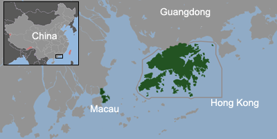
| | Pangea & Panthalassa Redux I have to declare again the extent to which my geographic world view was altered by information I discovered and presented in the last posting, particularly now that I'm setting out on a trip halfway around the earth and am writing this on the plane. The last item, the one that showed a counterintuitive straight-line sea route reemphasized to me that, although we know intellectually that we live on a globe, we too often look at flat maps and lose perspective—literally. Even Mercator projections don't do the trick and often confuse the issue. We need to visualize that roundness, and I've found a hokey way—hokey is helpful when it aids knowledge--to help myself do that when no actual globe is handy: the human head. I'll get back to that in a moment. | | | | I was particularly impressed reviewing Pangea, and with it, Panthalassa. I recently stated that, while north and south are finite concepts, since you've reached them when you reach a pole, east and west are infinite, since you never reach them. This remains true, yet is difficult to imagine, and the human mind likes tangibles. But the point that Pangea spread out like residual foam on a cappuccino does give us a basis for establishing tangibility. As I said, if we picture Africo-Eurasia as the home continents in the center, and recognize that the Americas wandered off to the west, leaving the "mighty" Atlantic as merely a flooded ditch left in their wake, and then picture the three sisters of Antarctica, Australia, and India doing their own thing in the southeast, thereby defining the Indian Ocean, we then have a "face" of the Earth's land masses. The image is that the western "edge of the earth" is the west coast of the Americas, and the eastern one is the east coast of Eurasia and Australia. That fully describes the Pacific for what it is, the remainder of Panthalassa. | | | | A coin has two faces. Both are equal, but we customarily describe one face as more noteworthy, calling it by the somewhat obscure term "obverse", while we call the other side by the more familiar term "reverse". I posit that those terms can apply to the globe to help us in our visualization: Pangea is the obverse side of the Earth and Panthalassa is the reverse side. To apply that to the earlier point, let's locate the Earth's land mass (the expanded Pangea) on the face of the human head. But it takes up more than half, so the Americas end up on the right ear and East Asia and Australia end up on the left. That leaves the back of the head for Panthalassa. Hokey, right? But it helps to envision. Let's trace that ship making a long straight line around the globe. It starts in Pakistan, below the left ear, and swings below Africa at the chin and the Americas at the right ear, rising around the top of the back of the head. It ends at Russia's Kamchatka Peninsula above the left ear, leaving the left ear the land area in Eurasia blocking the completion of the circle. What we've just traced is a straight line encircling the head (globe) below the chin and at the top of the back of the head. Envisioning the roundness of a head can be much easier than envisioning the roundness of the globe. | | | | A flight from New York to Paris will go from the right ear to the right eye. People standing in each of those cities are now more obviously roughly perpendicular to each other. Flying from New York to Hong Kong goes over the head from the right ear to the left ear (like earphones or earmuffs), since going around the back of the head via Panthalassa (the Pacific) is too long. This imagery works for me, especially since, as I write this, I'm flying over Baffin Island, to the west of the northernmost point of Greenland, on the way from New York to Hong Kong. | | | | Antipodes We've talked before about that beautiful word, antipodes, one of my favorites, both for sound and meaning, including on the trip to Australia, and it's a propos once again. (It's an.TI.po.diz, rhyming with "bees".) It's the point on the globe directly opposite any given point. The Greek root "-pod-" means "foot", as in "podiatrist", so the antipodes is the "anti-foot". Your foot presses down here and the antifoot presses down on the opposite side. Almost by definition, the antipodes switches hemispheres, both ways. If you're in the southern hemisphere, the antipodes is in the northern, and it's the same for the eastern and western. In addition, if you take a step to the north, your "anti-foot" takes one to the south in order to compensate. If you pick up an orange with thumb and middle finger, you are touching a pair of antipodes. | | | | British usage can refer to the Antipodes—capitalized—meaning specifically Australia and New Zealand, since the antipodes of the island of Great Britain falls in the Pacific east of New Zealand. You may hear of someone "emigrating to the Antipodes" in that context. But otherwise, it's a general term. The antipodes to New York falls in the Indian Ocean west of Australia, which was my excuse for returning from Perth round-the-world, via Dubai. | | | | The children's cartoon image, almost a folk image now, is that if you dig a hole straight down deep enough, you'll "end up in China". Cute as a cartoon, but where would you have to start? Not from Britain or the US, as mentioned above. You have to go to a globe to easily identify the antipodes of a given point, and so I checked at home recently, The antipodes of Hong Kong falls in Paraguay. As you go north to Beijing, its antipodes moves south to Patagonia, in southern Argentina. So it seems that if anyone is going to dig a hole through to China, it will have to be a South American. | | | | Cathay Pacific to Hong Kong July and August were a time to finish up postings, and were very busy. I'm not complaining at all—I love it. It took several postings to complete Newfoundland & Labrador, and then I thought the LHT/RHT one was appropriate, so I inserted that. I had started putting together online notes about China a year ago, as I was looking in to what I wanted to do, but they were incomplete, and there were some juicy topics I hadn't even started with, so the last couple of weeks of August involved long sessions at the laptop. The usual wee hours of working got later and later. They were pleasantly interrupted just a week ago today, the Monday before leaving, when friend Joe P. from California came to town, and we went to a most pleasant dinner at the 21 Club; great conversation, excellent food, and helpful service well beyond the expected. As the crowd thinned—we were the last to leave, which shows how we were enjoying ourselves--we asked the friendly and very competent waiter about celebrities, to which he asked "Oh, didn't you notice Carol Channing when you came in earlier?" Next time, I'm going to size up the room before sitting down. We ended up with a cellar tour, Joe's first, my third. | | | | Anyway, during the course of the week, I managed to get all the notes I wanted. Packing was quick. While I'd used the small wheeled carry-on to Canada—you may remember comments about that—I used the larger wheeled carry-on bag for China, the same I'd used for Greenland. What's good for six weeks there is good for four weeks here. | | | | When the paperwork for the tour arrived during the week, I noted what seemed to be two discrepancies. Everyone going was American, and I didn't see the name of the Australian I was told would join us. In addition, it didn't say anything about the other man that I'd heard was to join me out of Tibet, to Xi'an. I checked and found out that the two matters were related. Only recently were the organizers informed that the Australian man had died, and it turns out that he was the one who would have been going to Xi'an with me as well. In addition, I learned that the director of the two-week trip had also decided at the last minute to go along to Tibet. | | | | Shifting from my customary "home mode" to "travel mode", I had to set the alarm for 5 AM (!!!) Monday to allow time to get to JFK for a 10:05 flight. Cathay Pacific is the international flag carrier for Hong Kong, and I was pleased to have the opportunity to book it. There are only six airlines that Startrax awards its top five stars to, and this is one of them. I even like the name, including the old, romantic name in English for China, Cathay. (As it turns out, the only way to say "China" in Russian is using a form of that word, Кита́й (Kitay [ki.TAY, rhymes with "my"]). | | | | At the time of the return flight at the end of the China postings I'll update the list of long flights I've done, which I've now restricted to those with a scheduled time of ten hours or longer, and which presently has reached nine flights. For now I'll just say that my longest flight was that delightful one to Singapore in Business Class on Singapore Airlines in 2010, which lasted 18h50. The present flight now comes in second at 16h00. The return flight will come in third at 15h55. I'll also include some general comments on various good and bad airlines. | | | | As befits what will be mostly a rail trip, it was all rail to JFK as well, the #1 subway to Penn Station, the LIRR to Jamaica, the automatic, driverless, rubber-tired AirTrain to the airport. I was plenty early, but you don't want to screw up the beginning of a long trip. As soon as I reached Cathay Pacific, the uptick in quality was noticeable. The woman taking my ticket noticed that the day before had been my birthday, and congratulated me. Since hers was coming up within the week, she also high-fived me. It was a huge barn of a plane, and I noted that it was in First Class, not in Business Class, that they had the nice seat-beds I'd enjoyed on Singapore Airlines Business Class, but this time I chose Economy. I also knew I'd chosen my seat well online months before. While seating was 3+3+3 the last row on the left and right had only two seats, and I chose 71H the aisle seat on the right. It had more space and was quite comfortable. I'm supposed to have the same seat going home. | | | | There was a choice of two dishes for brunch, and three for dinner. Cocktails, wine, and beer were included. In between she came around with small sandwiches, and later on, with bowls of hot soup with ramen noodles and chopsticks. Economy Class on Cathay Pacific was quite nice. | | | | For travelers who really like geography, the TV route maps that in recent years have been appearing have been very appealing. Then they paled compared to Cathay Pacific's. I've never seen such graphics, almost to the point of 3-D. Not only was the entire route shown repeatedly, you'd see the plane flying at a present location with a "camera" circling it for a feeling of greater reality. Landmarks on the ground were identified. There was a satellite view of the airports at the beginning and end. It was quite spectacular. | | | | The text varied between English and Chinese, and as we took off from JFK, it was a bit droll seeing place names on the Rockaway Peninsula, and then Long Island, in Chinese. We flew over Connecticut and up the Hudson River Valley, then crossed to the east of Hudson Bay, with Churchill denoted on its southwest side. We crossed the Arctic near Baffin Island, then Siberia near Irkutsk, Mongolia near Ulan Bator, and China past Beijing and Wuhan (we'll be in both places) and down to Hong Kong. The flight covers over 13,000 km (8,000 mi). | | | | All of China is one spread-out, bloated time zone, UTC (GMT) +8 all year. While New York is normally UTC -5, in the summer with DST it's -4, so it's a 12-hour difference, with China AHEAD exactly one-half day, since 8 and 4 make a twelve-hour time difference. If it's 9 AM in New York, it's already 9 PM in China. This looked particularly odd on the read-out screen, since it said, perhaps, "Local Time at Origin 10 AM; Local Time at Destination 10 PM. Then it struck me that I won't have to change my watch at all the entire trip. Given that we left in the morning, the whole trip was in daylight, as we were trying to catch up to the sun. Out of curiosity I checked just where Australia fits in regarding China. As it turns out, all of China is in the same time zone as Western Australia, Perth for example, and two hours earlier than Sydney. Singapore is also in the same zone as China. | | | | I was very pleased to recognize some old hànzi "friends" on the plane. On the wall was a sign in both Chinese and English. The Chinese part said 出口. You will recognize it, too, if you reviewed the hànzi as suggested. However, I understand it even better now and feel I was right about why it means what it does the first time. I first saw it in 2009/36 in Tokyo. I recognized that two mountains crowded together, one on top of each other referred to the outdoors, and meant "outside". The second symbol is any opening from a mouth to a hole to a doorway. So I figured that "outside" + "doorway" means EXIT", and I was right. At that point I spoke to a Japanese woman, and in halting English she explained that the first symbol actually means "go out", so I corrected myself, but now I see, I did so unnecessarily. The languages we're discussing don't exactly have the parts of speech we're familiar with. I interpreted 出 as a noun, "outdoors", but she was looking at it as a verb, essentially "to outdoors yourself", so she told me it meant to go out. While she's right, she was going a step further than I needed. I'll stick to my first thought "outdoors+opening=exit". Anyway, we shouldn't concern ourselves about the 出口 until we land. [After landing, the signs were everywhere, but sometimes abbreviated to just the first character, 出. I felt cheated!] | | | | But another pair of old hànzi friends showed up on the TV screen. When it gave the time in Chinese, it said the time in one place was 10 下午 and the other was the opposite 10 上午. Can you figure out which is which? | | | | We learned that the short bar on the T-like character BELOW the top line (下) meant "low", or "below", and the short bar on the upside-down T ABOVE that line (上) meant "high", or "above", so that 下午 designates the "low" twelve hours, that is, AM, and 上午 designates the "high" twelve hours, that is, PM. I later looked up the second symbol to be sure, and quite logically, it means "noon", so we have "below noon" and "above noon". Actually, that's quite a bit clearer than a pair of abbreviations like AM and PM. | | | | It was announced that between meals, the snack mini-bar would be open in the galley. Since I was in the last row, it was very close. They had sandwiches, cookies, glasses of water and juice. At one point when I was there, they were slicing this gorgeous cheesecake, with a passion fruit glaze, and were giving slices to whoever happened to be standing there. It turns out it was the birthday of one of the flight attendants. I mentioned that my birthday had been the day before, so we celebrated together. Out of curiosity, I confirmed that it was Cantonese that the announcements were made in other than English. They said Mandarin is taught in some schools, but it wasn't typical for Hong Kong, which is just what I had suspected. | | | | After landing, we went through customs, which wouldn't be the last time. Hong Kong, Macau, and mainland China each have their own customs and visa systems, as well as their own money (fortunately, Hong Kong dollars are also used in Macau along with Macau's own currency). While the China visa requires a complex application and fee in advance, both Hong Kong and Macau are easy on-the-spot in-and-outs. I then went to the rail desk and bought a one-way ticket on the Airport Express. I don't understand why the people coming in on the tour later on needed to be met at the airport and assisted with this. I also got myself an Octopus Card for use on all public transportation (more details in the next posting). My first two trips would be on the Airport Express, with its own ticket, and then the Star Ferry, with the Octopus Card, after which, though still mid-afternoon, it would be time to settle in and get some rest. | | | | The Pearl River Delta Hong Kong and Macau are now again part of China and yet are not part of China. The Chinese spoken there is the Cantonese spoken in Guangzhou (Canton)--as well as in surrounding Guangdong province--at the inland apex of the triangular Pearl River estuary (Map by Alanmak, Serg!o). While many estuaries are not shaped like the Greek delta, Δ, this one definitely is. With Guangzhou at the apex of the Δ (not named here), Hong Kong is at the southeast corner and Macau at the southwest. And yet they are still apart. We'll discuss Hong Kong and Macau first as separate entities, and then talk more about China proper once we cross the border going up to Guangzhou. Meanwhile, on the map, notice how much larger the upstart Hong Kong is, settled by Westerners in the 19C, than Macau, settled by Westerners in the 16C.
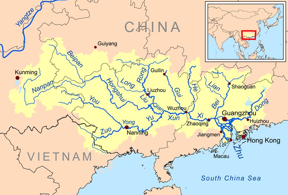
| | | | We should look at a clearer map of the Pearl River Delta, but I can't link to it because of copyright restrictions, whereas you as a third party can. Copy-and-paste this: http://www.johomaps.com/as/china/guangdong/pearldelta.html | | | | The first thing you note is that the whole delta is well-populated. Hong Kong is not isolated, but is directly joined to the huge city of Shenzhen beyond the red dotted line. Macau's own red line indicates its two connections with the large city of Zhuhai, via the slender land connection to the north and the Lotus Bridge to the west, discussed on our review of traffic (2013/15). Now follow the delta up to its apex at Guangzhou (Canton). Since this is a delta, it's hard to follow just what flows where, but let's pick out the essentials. As we do this, I'm going to suggest you learn four words. They'll be very useful later on, and you'll enjoy what we do with them. | | | | On the map, north of Shenzhen, note the Dong Jiang (you can write it in English as one or two words) flowing from the east into the delta. The name thus means East River. Learn the word dong as meaning "east". (You'll see more of the word jiang later, too, but that's not the point here. By the way, the Hong Kong government has purchased Dong Jiang water from Guangdong (dong!) Province since 1965, and this river covers 70% of Hong Kong's water supply today. | | | | As we continue looking at the maze of rivers that comprise this delta, look to the west for the Xi Jiang, or West River. Learn xi as meaning "west". The Xi Jiang is a little sneaky, since it cuts off and runs down the western part of the area and reaches the sea west of Zhuhai and Macau without exactly entering the center of the delta. | | | | Finally, find the Bei Jiang (North River) as it enters the Xi Jiang out west. Learn bei. These three rivers together comprise what is usually considered to be the Pearl River. Here's a surprise. There really isn't anything called the Pearl River. It's the cover term for the basin of the Dong, Xi, and Bei rivers. Or, looked at differently, the three are tributaries of the Pearl River, since they all share the Pearl River Delta. In other words, all three together are the Pearl River, or Zhu Jiang. | | | | | | Not knowing Chinese, I looked this up on Google Translate. Zhu is, as far as I can tell, a shortened form. (Remember the two symbols for "exit" are often reduced to just the first symbol.) The whole expression for "pearl" is actually zhenzhu. zhen means "precious" and zhu means "bead". Isn't Chinese imagery beautiful? |
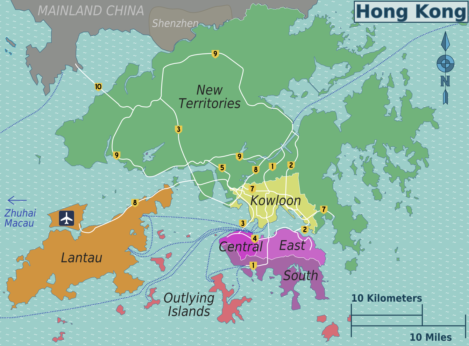
| | | | One more quirk. As the Dong Jiang flows through the premier city of the area, Guangzhou, it actually is called the Pearl River, in other words, the city is on the Pearl, not the Dong. Think of the whole thing as a group effort between rivers (!!!). The reference to pearls is because of pearl-colored shells that supposedly lie in the river as it passes through Guangzhou. | | | | It's time to look at the entirety of the Pearl River Drainage Basin (Map by Kmusser) and see how extensive it is. Note that only the Delta is actually labeled the Zhu (Pearl). Check out the Dong, Bei, and Xi, and see how many additional tributaries the Xi has. Measured from the furthest reaches of the Xi, the Pearl River system is the third longest river in China, at 2400 km (about 1500 mi) after the Yangzi (modern spelling, and shown on map) and the Yellow Rivers, and second by volume after the Yangzi. The Xi is navigable for its entire length. Over 2000 years ago a canal was dug connecting tributaries of the Xi and Yangzi, so that the Pearl River Delta at Guangzhou is connected all the way down the length of the Yangzi Valley to Shanghai at the Yangzi Delta. | | | | Note one last thing on this map. On the left, two tributaries are the Beipan and the Nanpan. We already know bei, so now we learn that nan means "south". You'll also see the city of Nanning, so you can guess where we'll be going with this word study. Our four words, by coincidence, are alphabetical going clockwise from the north position: bei, dong, nan, xi, but more importantly, learn bei and nan as opposites, and dong and xi as opposites. | | | | SARs To clarify the earlier statement that Hong Kong and Macau are now part of China and yet are not part of China, one has to realize that they are both considered Special Administrative Regions (SARs) of the People's Republic of China (PRC). That is, they are autonomous territories that fall within the sovereignty of the PRC, yet which are not a part of it. The political theory is "One China, Two Systems", and that double standard includes Taiwan. The SARs maintain their own governments, multi-party legislatures, legal systems, police forces, monetary systems, customs area, immigration policies, official languages, postal systems, and educational systems. To some degree, they also have separate external relations. This is why there continue to be three different currencies and three different visa requirements, not to mention the left-hand (Hong Kong and Macau) and right-hand (China) traffic differences. In the treaties signed between Britain and China, and Portugal and China, this status will remain for at least fifty years. | | | | Hong Kong Hong Kong became a British colony as a result of the First Opium War, 1839-1842. Originally the colony was limited to Hong Kong Island proper (Map by Peter Fitzgerald & Globe-trotter), but in 1860, an area of the mainland opposite Hong Kong Harbour called Kowloon was added, and then in 1898, a huge area was added which to this day, well over a century later, is still called the New Territories. Of principal interest to the visitor, however, is the north side of Hong Kong Island, principally the area called Central, plus the adjacent area of Kowloon across the water. Beyond that is the large, verdant island of Lantau and some additional small islands. I was only on Lantau coming in from the airport (shown on its own artificial island) and only in the New Territories on the train leaving Hong Kong to Mainland China via Shenzhen (shown). Note the direction toward Macau and Zhuhai to the west. | | | | There are two other details on this map we can discuss here. Click on highway 2 to enlarge this map and note the yellow peninsula pointing toward the number 2. This is the former airport, Kai Tak, which we'll discuss below, but for now, note how crowded in it was. Then click on highway 1. Where the 1 is is the town of Aberdeen, facing tiny Aberdeen Island across Aberdeen Harbour. This area on the more remote south side is where British sailors first encountered local fishermen, who told them in Cantonese that that waterway, today's Aberdeen Harbour, was called Heung gong (Fragrant Harbour). Eventually, the name was extended to include the entire island, and then also the entire colony. Today, the name continues with both meanings. If you're in Kowloon, you can say you're going to Hong Kong in that sense, even though you're already in Hong Kong in the other sense. The name was sometimes written as one word, but was officially adopted as two words by the government in 1926. In Mandarin, the pronunciation of the name, rendered in Mandarin-based pinyin, is Xianggang. While that would be the basis for the updated name elsewhere, the official name nevertheless remains Hong Kong. | | | | Hong Kong's population is 93.6% ethnic Chinese. The local Han Chinese originate from neighboring Guangdong province, mainly from the cities of Guangzhou, as well as Taishan, which is on the coast west of Macau. Hong Kong's currency, the Hong Kong dollar, is the eighth most traded currency in the world. | | | | Hong Kong is one of the most densely populated areas in the world, and is part of the densely populated Cantonese region (Map by Bambuway) in the south of China around the Pearl River Delta. The other densely area is around the deltas of the Yangzi and Yellow Rivers in the northeast. Based on the 2010 Census, the darkest red areas of this map show over 500 people per km², the lightest pink less than 5 per km². The density of Hong Kong's population caused denser constructions, usually upward, meaning that Hong Kong today is the world's most vertical city. This density also led to a highly developed public transportation network so that the rate of use of public transportation exceeds 90%, which is the highest in the world. | | | | Curiously, the rate of precipitation (Map by Alan Mak) is highest in the southeast of China, including Hong Kong, since it's just where the other Sinitic languages than Mandarin, are located. On both maps note how much less densely populated—and drier—the western areas are, including Tibet. | | | | Airports, Old & New We quickly spoke about two airports on the above Hong Kong map, and we'll discuss them chronologically. Kai Tak Airport was Hong Kong's international airport from 1925 to 1998. Its location was notoriously difficult and dangerous. I'd never heard of Kai Tak until last summer, when we discussed the Madeira Airport (2012/8), and Kai Tak was mentioned in connection with it. The comparison was that the Madeira Airport, even improved, is considered the Kai Tak of Europe because of its approach to runway 05. The History Channel program "Most Extreme Airports" ranked Madeira as the 9th most dangerous airport in the world (and 2nd in Europe after Gibraltar International Airport), and it listed Kai Tak as the 6th most dangerous in the world. | | | | This is a satellite image of Hong Kong Harbour. Looking to the right of the Kowloon Peninsula you can see the single runway of Kai Tak running down into the harbor in the midst of a built-up area. This view following is the reverse view, looking south toward Hong Kong island, of the single runway of the former Kai Tak Airport (Photo by Noooob). With the many buildings and mountains in the area and surrounded by water, landings at the airport were dramatic for passengers, and demanding for pilots. | | | | Fortunately, with the building of the new airport, Kai Tak was closed--as an airport. That may sound like a strange way to put it, but what happened to Kai Tak is indeed strange. On 13 June of this year it opened as the Kai Tak Cruise Terminal and welcomed its first passengers. The former runway can berth two large 360 m (1181 ft)-long vessels disembarking 5400 passengers and 1200 crew. It will supplement, and can take much larger ships than, the 1966 Ocean Terminal on the southwest side of Kowloon. | | | | | | Terminology such as "port" and "ship" had always referred to maritime use until the Air Age, when the terms were expanded to "airport" and "airship". That change then resulted in a back-formation to refer to a "port" as a "seaport", as needed. Yet one is hard put to remember another instance of an airport physically evolving back into its ancestor, a seaport. |
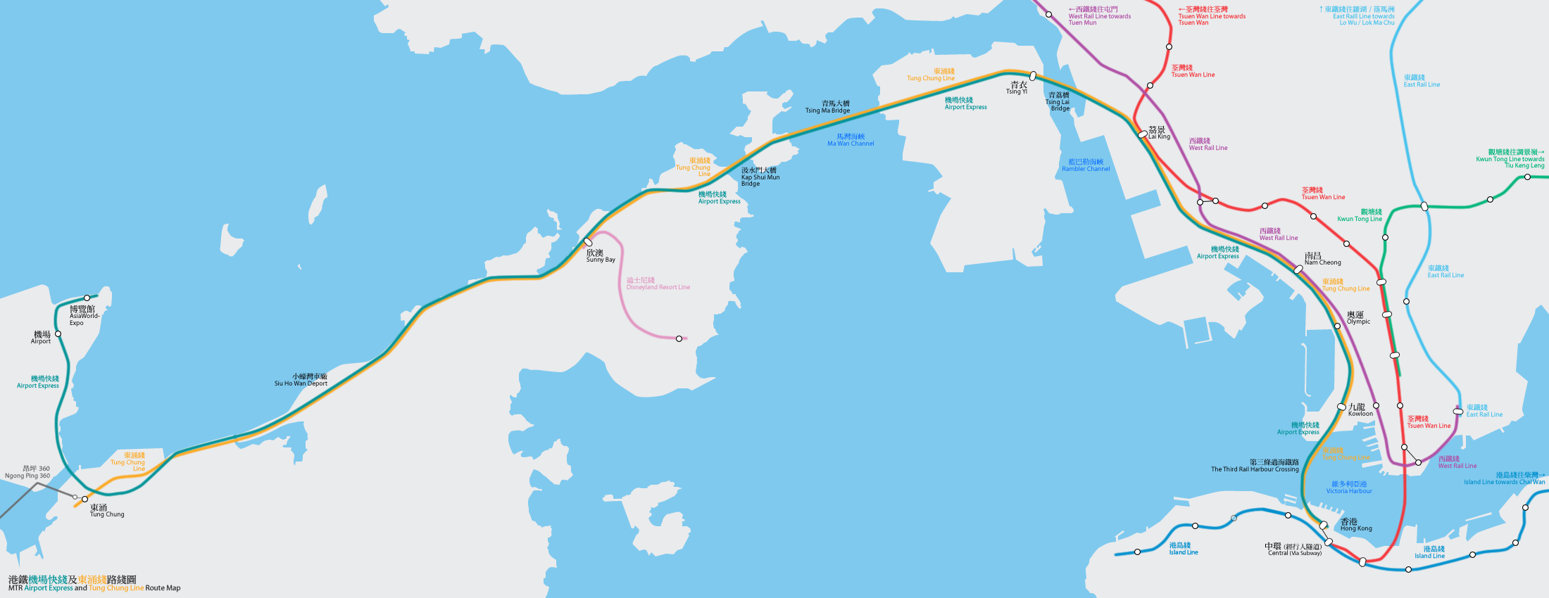
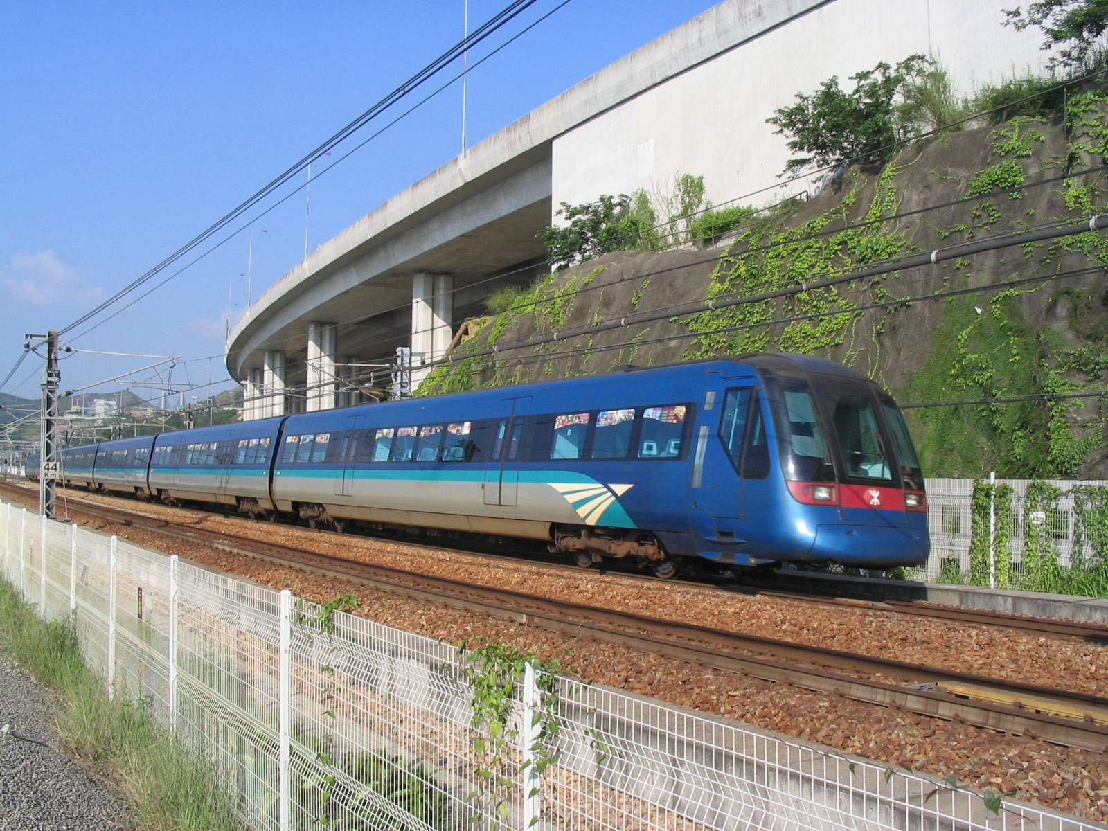
| | | | In 1998 the new Hong Kong International Airport opened north of Lantau Island on the island of Chek Lap Kok (Photo by Wylkie Chan, from a scheduled flight), which is largely reclaimed land from the airport's construction. When it opened (though no longer) the passenger terminal buildings were the largest in the world. The airport is connected to Hong Kong's rapid transit system, the MTR (Mass Transit Railway), via the MTR's Airport Express (Map by Bus_28a, Mtrkwt), shown here in blue as it largely parallels the MTR's Tung Chung Line. The two final stops of the Airport Express (Photo by Baycrest) are in West Kowloon and, crossing under the harbor, Central, which is the main area of Hong Kong Island. The trip takes about twenty minutes. | | | |
| |
|
|
|

