|
Reflections 2013
Series 16
August 22
Independent vs Group - East Asia, Earlier - China Trip - China Review - Pangea
| | Independent Travel I've always thought that Independent Travel is the only way to go. I decide where I want to go, what I want to do there, find and book hotels, book transportation, and, most importantly, walk the streets or drive the roads myself, armed with a good map and a good guide book supplemented by other online research. Recent postings from the Azores to the Canaries, from Ottawa to Saint John's, bear witness. And if one can take a trip by car close to home, one can do it elsewhere. Beverly and I always did it that way, and now I do it that way. Self-reliance, locally or afar, embellishes the soul. | | | | When I travel I make two adjustments. I adjust my body clock, so that instead of working into the wee hours at home, usually writing, and then getting up late, my travel schedule is to bed early and up early to be in time for the posted breakfast hours and to be able to catch that early train or plane. | | | | I also skip lunch, regularly. I have a full breakfast, and a full, relaxed dinner in the evening. I do not stop all the fun of going around town by something as mundane as lunch, and you haven't seen or heard of any lunch breaks when we've walked or driven around together in the postings. Although you may not agree, this is how I enjoy to travel, and it makes dinner all the more welcome. | | | | Group Tours I have taken group bus tours under certain circumstances over the years and primarily dislike the regimentation. I also often have a problem with the schedule of visits established by others. I believe firmly that if you want something done right, do it yourself. I've found that even with a good tour, there are negatives. Last year in Reykjavik, we had an excellent guide on a beautiful bus take us around to the sights. For a tour, it couldn't have been better. Yet we were rushed at Þingvellir, since the schedule was paramount. If I'd rented a car and done it on my own I'd have had more flexibility. When we were at the Gullfoss waterfall we were rushed again, and it was in my haste to get back from the viewpoint to the bus that I fell off a rock and caught myself on my left hand, which needed medical attention on the ship, my left wrist still has an occasional twinge. | | | | Worst is the obsession with lunch. Now I do see that others want lunch on a day tour, so I'll yield to that. While I'd love suggest a power bar while on the bus, that might not go over well, so how about sandwiches included in the tour? In Iceland, we all went to that restaurant for that included, lush, 90-minute sit-down lunch, even though we were there to see the geysers across the road. Which was more important under the circumstances? The service was slow, we ended by picking up dessert and coffee and bringing them to our tables on our own, and then had to run quickly across the road to have just about 40 minutes to see the geysers. In Churchill, on the other hand, there were quality wrapped sandwiches (also soup, pastries) right on the tundra buggy, so we didn't have to pause watching the polar bears. And even with all the time pressure and typical lunchtime craziness, I'm forced to call the Iceland tour one of the better ones I've taken. But if I'm ever there again and want to revisit any of those places, I'll rent a car, do it on my own—and pass on lunch to all the more look forward to dinner. | | | | East Asia, Earlier, 1: Korea 2005 I was wary when I made my first trip ever to East Asia, to Korea in 2005. Despite years of travel, I had no self-confidence that I could pull it off doing it independently. There were several factors that worried me. First was the writing system. As it turns out, Korean writing, unlike Chinese characters, IS alphabetic, but it's not something you can pick up on the fly. How do I walk the streets on my own not knowing where I am and not being able to read street names, even if they should be posted, which is rarely the case? How do I take the subway and know where I am? Secondly, one unusual thing really concerned me. There are house numbers in Asian cities, but—hold your hat—they're not consecutive. Numbers are usually given out in the order buildings were built, so, on a given street, number 71 might be next to number 10. | | | | Fortunately, this first trip to East Asia was very short, just one day. Seoul was a connection on my World by Rail via Siberia trip. I'd crossed North America from New York to Halifax to Vancouver, had flown Korean Airlines (very nice) to Seoul to continue the next day with them (less nice) to Vladivostok, where I'd take GW Travel's Trans-Siberian train tour to Moscow, then continue independently by rail to Berlin, Paris, London, and Southampton, to take the QM2 to New York. But the connection in Seoul required an overnight. It was a long trip, and I couldn't add too much time, but I managed to slip in a day and second night in Seoul, so that I had a day to look around. I booked my hotel online, found out how to take the airport bus there and back, but how would I see Seoul? | | | | As much as I wanted to travel independently there (2005/7), I found a tour guide online and did get a pair of very nice guided tours as I requested them, in the morning to the Demilitarized Zone (DMZ) and after lunch on a tour of Seoul. It worked out well, I saw what I wanted, but, with my good sense of direction, I was disoriented the whole time within the city because I wasn't finding my own way about, an essential requirement for me. And yes, there was that perennial lunch. The guide dropped me off at a restaurant when she went off somewhere to eat. I don't recall if I ate or just waited outside for her to come back. Also, if I'd been on my own and had also allowed a second day, I could have taken the high-speed train from Seoul to Busan. Independent Travel is best. | | | | | | As we speak of East Asia, from what I just said, you see I do not consider Vladivostok to be in Asia, but consider that Russia extends Europe to the Pacific. I made this argument—whether you agree or not—in 2005/2 "Continents", where I defend the statement that "Europe has a Pacific Coast". I review all continents there, but make the point that Eurasia, in reality one continent, is artificially divided, not geographically, but culturally into The West and The East. I accept this, but while the traditional dividing line near the Black and Caspian Seas is sensible, running it then north artificially across Russia at the Urals only might have made sense when the Urals were a real barrier, crossed in the 5C by the invading Huns and in the 13C by the invading Mongols, and when Asian peoples speaking Uralic languages (Hungarian, Finnish, Estonian, Saami [of Lapland]) moved west and settled in Europe. We accept these peoples as Europeans. But then Russia moved east to the Pacific in the 19C and brought Europe to the Pacific, and I accept that as well. This has become even clearer with the demise of the Soviet Union, so that Kazakhstan and the other 'Stans "moved" more clearly in Central Asia, leaving Russia alone to bring Europe with it to the Pacific.
I say that the de facto Europe/Asia border (Map by STyx), today still runs from the area of the Black and Caspian Seas, with Turkey and Iran to the south and Georgia-Armenia-Azerbaijan to the north, but up only to the Russian border, which it then follows to the Pacific. This then keeps all of Russia, all the way to the Pacific, within Europe, while south of the line is Kazakhstan and the other 'Stans in Central Asia, and then Mongolia and China in East Asia. There is no such expression as "North Asia", because no one feels that area to be Asia. It's Russia, and is de facto Europe. In the modern world, Europe is Northern Eurasia and Asia is Southern Eurasia, subdivided into Central Asia, West Asia (in the Middle East), South Asia, Southeast Asia, and East Asia.
While "the Orient" is now an over-romanticized concept ("the Occident", too), and calling Asians "Orientals" is considered demeaning, I also decry the use of the term "Far East" for East Asia. The term Near East to describe the Balkans of Europe died when Turkey left the area except for the Istanbul region. We remain saddled with the term "Middle East" because it's a convenient way to describe the overlap of West Asia and North Africa. But those terms, along with "Far East" describe sailing distance from Western Europe, and have little value in the modern world, where a so-called "Far East" is west of the Americas and north of Australia, and you can fly there in a matter of hours. "East Asia" is the best way to describe the region.
|
| | | | East Asia, Earlier, 2: Japan & Taiwan 2009 It was a world of difference, night to day, four years later in 2009, when I went to Japan (2009/34 to 42) and Taiwan (2009/43-44). I don't know where I got the knowledge, and ensuing courage, in between, but it was all a breeze, and I did every moment on my own, and needed no one to lead me around by the hand. I had a rail pass in Japan and in every station in the country and on the subways in Tokyo, Kyoto, and Fukuoka all illuminated signs would be first in Japanese writing, then in the Latin/Roman alphabet. Announcements were also made both in Japanese and English, including on the Tokyo subway. For a self-guided walking tour, even if the streets had signs on them—which they usually didn't--it wasn't important. With a good map, or one downloaded at home in advance from Google maps, you just count out streets and cross streets until you find your route, including finding restaurants. I never once went wrong, and both Japan and Taiwan were a delight to maneuver solo. | | | | East Asia Now: Upcoming China Trip 2013 But I wasn't ready to dare to do the same with (mainland) China. Hong Kong and Macau, I knew were "outside China" enough and would be easy on my own, but not only was China a huge country, "China is China", as I kept on telling people, and still do. There's the political side, the bureaucracy, and the police and soldiers, and, although Beijing and other large cities may have rail and subway signage in Latin/Roman, I wouldn't be comfortable going around the country on my own. Also, I had plenty of experience going—and driving no less--behind the Iron Curtain in 1971-2 in Eastern Europe, to say nothing of driving to and in the Soviet Union itself, and while we enjoyed ourselves throughout, and have stories to tell, it was stressful, and we were glad when we drove across the Finnish border and out of that atmosphere. So I knew that my ever visiting China was going to be a problem, and might never happen. | | | | The opportunity did happen though, unexpectedly, in conjunction with two other sets of plans. I had just come back from Reykjavik last summer, flying to Boston and taking Amtrak to New York. I had two related things on my mind and started working on them immediately. First I wanted to look into going back to Greenland to visit the Eastern Settlement of the Norse that hadn't worked out when we tried to add it to the cruise. I researched it, reviewed the difficulties, consulted with friend Paul for input, and decided against it. In its place appeared, in a long delayed writeup (as were all the writeups of the Atlantic Isles trip last year), "A Vicarious Visit to the Eastern Settlement" as part of the last posting of the year, 2012/25. | | | | While I was trying to make a decision about Greenland right after Reykjavik, I also decided it was important to continue the Atlantic Isles trip to Newfoundland, so in those first days of July last year, as I decided against a Greenland revisit, I decided FOR going back to Newfoundland, and started planning the Newfoundland trip that came to fruition just this past June (2013/10-14). And right as I was working on those two projects, I got an email with an "offer I couldn't refuse" about China. I said to myself, my cup runneth over with travel options. | | | | I do follow rail matters, and I have regularly gotten emails from a group promoting high-speed rail in the US. This new email I got described a two-week trip to China, where we'd see the major sights, but it would also be a special-interest tour via high-speed rail (HSR), centering on rail in general and on HSR in particular. In addition to that, the group was arranging travel details with someone I've done business with before (Australia, Eastern Oriental Express, more). It seemed just what I needed, even though it was a guided tour, a sort of had-to-be. | | | | In Europe I've been on a number of HSR trains. As for East Asia, refer to this map (Map by WouterH). In Japan I've been on trains, including HSR Shinkansen trains shown, between Sapporo and Fukuoka, where I flew to Taiwan and later took Taiwan's one HSR line all the way to the south and back, just to ride the train. | | | | I promptly sent in my deposit, but also promptly started extending the trip, both before and after, and so my personal trip will have three parts, running four weeks. It's essentially the whole month of September minus the 1st (my birthday, and a packing day) and the 30th. I booked my round-trip flight New York-JFK/Hong Kong with Cathay Pacific. (Skytrax now lists only seven five-star airlines, all Asian ones, and I've flown Singapore and Qatar, and will now add Cathay Pacific.) | | | | China 2013, Part 1 of 3 Part 1 of my personal trip will be gloriously independent travel in Hong Kong and Macau, which will cost me little, since I got five nights free on points from Starwood's Sheraton Hong Kong in Kowloon, on the north side of Hong Kong Harbour. That will give me four days in Hong Kong, and one day I'll take the high-speed ferry over to Macau. | | | | China 2013, Part 2 of 3 Part 2 will be the organized two-week tour. I'll walk over to the Hong Kong hotel that the tour has booked, the Royal Pacific, and spend two nights there. On the day in between, there will be a "transit tour" of Hong Kong, which I'll enjoy, especially knowing I'll have already seen the principal sights I want to. After that, the tour will enter China by rail and visit Guangzhou (Canton) then via Wuhan to Nanjing; to Shanghai; to Quingdao; then to Beijing, with a side visit to the Great Wall. In addition to the usual sights, there will be technical visits to factories. In Shanghai we're to ride the maglev (magnetic levitation) system to the airport and back, just for the ride. I understand the tour has reached the full quota of 24 participants, and after Beijing, most will fly home. Breakfasts are included, as are, inevitably and unfortunately, most lunches. I don't know what I'll want to do about dinner, because I usually gain weight when traveling because of too much restaurant dining. Maybe I can wing it in the evening. I'll have to see. | | | | China 2013, Part 3 of 3 Part 3 was inevitable. The moment I read the invitational email for the trip, I spotted two things missing. It didn't go to Xi'an, home of the terra-cotta warriors. And it didn't go to Tibet, whose capital, Lhasa, was finally reached by rail in 2006 by a spectacular high-altitude train (a regular train, not high-speed) that pumps in oxygen to the coaches, like a plane does, and also has emergency oxygen available. I've been interested in that trip since alerted to it a few years ago by Tim Littler of GW Travel in the UK. He has his own luxury train make that trip, but the regular one would do me fine. | | | | | | I picked those two destinations as lacking from the schedule off the top of my head, still being rusty on Chinese geography (I'm getting better, as readers will, too). Afterwards, since there's no Michelin Guide for China, I picked the next best thing that evaluates sights by stars, Frommer's, and bought the very fat Frommer's China. After reviewing it thoroughly, and checking out what there is to see in the cities we WILL be visiting, so I know what to complain about if I see something important is being skipped, I found that Xi'an and Lhasa were really all that was missing that I wanted. I know there are other sights in China, such as gorges and river cruises, but, knowing you can't see everything in a large country, I put the urban culture first, along with language review and the rail connections, and I decided I had chosen well just to add those two locations. |
| | | | Along with sending in my deposit, I mentioned my two additional interests. As they were putting the trip together, they included two optional add-ons, an extension to Lhasa or an extension to Xi'an, both out of Beijing at the end of the main tour, and sent out the proposed itinerary to those who had signed up already, plus anyone else interested. These extensions would be met by local guides arranged for through local Chinese travel partners. | | | | Well, that was nice, but not nice enough for me. I'm not about to choose between two destinations I want. While the extensions are not individual travel, they wouldn't be as pre-controlled as the main part of the tour (I hope). I told them that I wanted both, and in sequence. Here was my logic. While the new high-altitude train starts close to Tibet, there are in China cross-country trains to many destinations, including one from Beijing to Lhasa, taking two nights. Even though Xi'an is roughly on the way, I didn't want to interrupt such a beautiful long-distance trip. So I told them I wanted the Beijing-Tibet extension, but then I wanted to backtrack and return by train down to Xi'an, which would take one night. And in addition to the terra-cotta warriors and some other sights that had been suggested, I asked to take the golf cart ride along the top of the entire, encircling, Xi'an city wall that I'd read about in Frommer. You may or may not like my logic, but so be it. It'll make a nice trip. | | | | For a long while, as far as I could tell, I was the only one going to Tibet at all, and certainly no one would want my loopy up-then-back-down version. But not so. I must be a good trip planner, because as it turns out, of the 24 participants on the main trip, a total of 7, including me, are going to Tibet! We will be 5 singles and one double. Apparently, one couple is going to Xi'an directly from Beijing. Once I myself am ready to leave Xi'an, I've arranged a flight from Xi'an to Hong Kong to connect to the return flight to New York. | | | | China Review I have a dilemma, and I see only one way out of it. The visits to Korea, Japan, and Taiwan are all cross-referenced above, in case anyone, long-term reader or new reader, is interested in bringing together a large-scale overview of East Asia. I just skimmed some of it myself, and was rather nostalgic. Japan, in particular, was such a good trip, Taiwan, too. I still enjoy the image on one posting that illustrates the four blended writing systems Japanese uses, including Chinese characters (hànzi, which the Japanese call kanji) by printing a sentence in different colors (2009/32). And I'd forgotten I'd written some original haikus (2009/40), which, I swear, just came to me while walking around or sitting on a bench, absorbing the autumnal leaf-colored atmosphere of Japan. It was a sweet time. | | | | Let me snap out of that reverie and get back to the dilemma. When I wrote about Taiwan, it also made sense to write about all of China, including the hànzi as used in Taiwan, to say nothing of their use (again, called kanji) as one of the Japanese systems. I like what I wrote, and don't want to reinvent the wheel. I also think it's a fool's errand to copy the same text into this posting. Therefore, I'm going to limit this China Review, not by merely giving an informational cross-reference as I often do, but instead continuing the thread of the present conversation via former postings, two major ones in particular. I strongly recommend the reader go back as indicated in each case to review the subject matter, since everything from now on, through all the postings on China, will assume information from there. There are also some excellent maps of vital importance to understanding what we're doing and talking about. And if you read it before, at least skim it again, since, when I went back, details I'd forgotten myself came back to me, including being able to read the hànzi shown and discussed there, with which I'd gotten rusty. I've also updated some maps. And by the way, as you know, internet links from the past die, far too often, which is a plague to all websites, including this one. I've reviewed the ones we're going back to now and have repaired them where necessary, replacing maps and pictures as needed. Open another window and go to Travelanguist.com. The following hereby becomes integral text to this current China posting. | | | | 2009/29 East Asia – Writing Systems Review East Asia: | | | | | | Distinguish between looking at the area politically as opposed to culturally, ethnically, and linguistically.
Review the two maps showing the proximity of these East Asian cultures, the second one of which shows six of the cities to be visited, mentioned above.
In what way is China similar to what the Soviet Union was, or even Austria-Hungary?
Who are the Han?
On the map of Administrative Divisions of China, make particular note of the three large Autonomous Regions in the West and North.
|
| | | | Review Regional Language Relationships: | | | | | | Note, on the two ethnolinguistic maps of China, the language situation in the three Autonomous Regions; also the location of the Sino-Tibetan languages; and how the "Sino-" ones are broken down into Mandarin and the other sinitic languages.
Be aware that Mandarin and the other sinitic languages, usually referred to politically by the Chinese government as "dialects of Chinese", are generally mutually unintelligible, a fact hidden by the façade of the non-alphabetic writing system. The government considers all Han Chinese a single nationality, and therefore they speak "one language", with "dialects". Cantonese, for example, is far more different from Mandarin than any two Germanic languages, say Dutch and Icelandic, or any two Italic (Romance) languages, say Portuguese and Romanian. These European pairs all use the same alphabet, but are not considered the same language, and if there's no expectation that a speaker of Romanian will understand Portuguese, there's also no expectation that a speaker of Mandarin will understand Cantonese, written characters notwithstanding.
|
| | | | Under Writing Systems, skip if you wish the information on alphabets and syllabaries, but concentrate on logograms: | | | | | | Know that logograms are "word-writing", using single or double symbols for words.
Realize that "&" is a logogram representing the word and concept "and" in English; it is non-alphabetic and does not represent sounds, but instead the concept of the whole word. Similarly, understand that the Chinese character (hànzi) 山 is a logogram representing the word and concept "mountain" in Mandarin, which is verbalized as "shan".
Realize that the terms "traditional Chinese" and "simplified Chinese" do not refer to the language itself but to the writing of it, to original, more complex hànzi as opposed to ones where strokes have purposely left out. There is no change in what you say here, just how you write the symbol. It's the equivalent of spelling reform, but applied not to an alphabet, which involves spelling, but to logograms, which involve concepts, and are drawn with strokes (lines). It's mainland China that did the "spelling reform" to develop "simplified Chinese", and Singapore and Malaysia have gone along with it. In these places, traditional symbols are used just as a gimmick in shop signs and logos to evoke the past nostalgically, just like a color movie might show a flashback in black-and-white to evoke the past. "Traditional Chinese", though, is standard in Taiwan, Hong Kong, and Macau, and by many overseas Chinese, who, as might be expected, tend to be tradition-bound to the "old country" as they remember it.
|
| | | | 2009/31 Writing Chinese Review Hànzi. | | | | | | This is an intellectual and cultural exercise that anyone should want to get involved in. Distinguish between logograms that are pictograms and those that are ideograms, then see how they can be compounded into double symbols. Just the slightest bit of concentration should allow you to read the English paragraph filled with hànzi, and you should feel very pleased with yourself. |
| | | | Review Romanization. | | | | | | Understand why Wade-Giles in the past served its purpose for outsiders, and why pinyin is superior for insiders, that is, Chinese speakers. Understand why the popular Chinese beer still known in the West by its Wade-Giles name of Tsingtao, comes from the city of the same name now written Qingdao in pinyin.
Familiarize yourself with some of the features of pinyin to be able to read Chinese place names, while not with perfect native pronunciation, but with a reasonable westernized pronunciation. Try to intellectualize the four tones of Mandarin, whether or not you can repeat them.
|
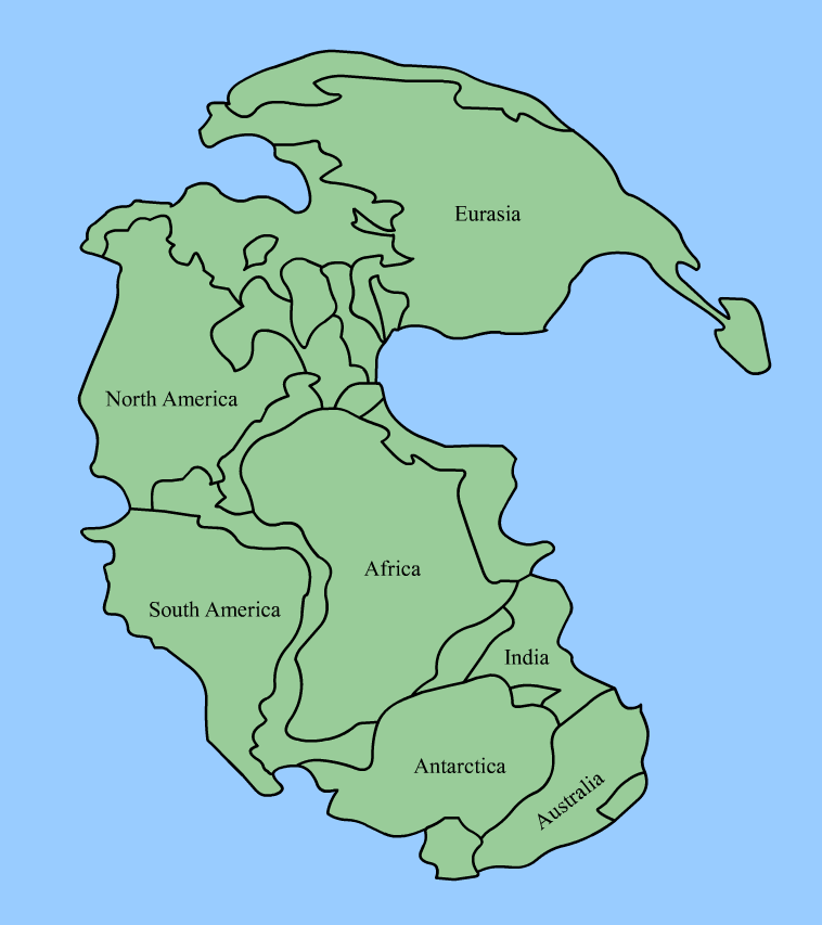
| | | | 2009/31 [Partial] This posting deals with writing Japanese, but their version of hànzi is called kanji, and while they may vary slightly, they're still very close. Read the short section on kanji and pick up a few more characters. | | | | 2009/33 [Partial] You may want to (re)read the sections on the Silk Road and Marco Polo, since they certainly apply, but that's up to you. Otherwise, zip down under "Internal Place Names" to "Names for China". | | | | 2009/36 [Partial] This is again about Japan, but has some good kanji, so use Ctrl-F to Find "There was a slight backup" and read five paragraphs up to "when in Rome". Then you'll always be able to find an 出口 by following posted signs (no, it's not a toilet). | | | | 2009/37 [Partial] Another Japanese posting, but the first part works with kanji again, and is followed by questions to guess the answers to, with answers afterward. Since kanji are really hànzi, it's good practice. You'll then be completely up-to-date and ready for future postings. | | | | Pangea It's time for a change of pace based on some online maps that were sent around recently in emails. Ever since the sixth grade, when I picked up a magazine the teacher had left on the "enrichment table" and first learned about continental drift, the subject has fascinated me, because of my love of geography and innate sense of direction, and knowing "where places are". At the time, it also mentioned something about all the continents being clustered together at one point, but the details of that interested me less, mostly because most of the drawings you see of that clustering, referred to as Pangea (Image by Kieff), look like this chaotic representation. A clustering, yes, an unusual lineup of locations, but little detail and little to get excited about.
| | | | But a new map has gotten me quite excited, and I now have an umbrella comprehension of geography I never had before. It led to more research. I now know that this periodic clustering into supercontinents, which then broke apart as the tectonic plates separated again, is apparently cyclical, and that there may have been several in-and-out groupings before Pangea, the most recent one. That boggles the mind to the point that it's worth putting that thought on the back burner and looking at today's geography as primarily descending from Pangea, with the odd detail from any earlier variation. | | | | Pangea (pan.GI.a, GI as in "gee!"), is Greek, composed of πᾶν/pan, meaning "all" or "entire" and Γαῖα/Gaia, meaning "Earth", so that Pangea is literally All-Earth. (It's the same "geo-" as in "geography" and "geology".) But given that our Earth is more accurately the Water Planet, the existence of all the land clustered together in Pangea immediately implies that all the ocean was also clustered together. This gives us the concept of Panthalassa, which combines πᾶν/pan with θάλασσα/thalassa, meaning "ocean", so that Panthalassa is the All-Ocean. In other words, Pangea is entirely surrounded by Panthalassa, which then spreads around the rest of the planet. Heady stuff. | | | | Pangea formed about 300 million years ago and began to break apart around 200 million years ago, which means you had about 100 million years in which you could take a hike from the Palisades on the west bank of the Hudson River across the way to Morocco and back—these two areas are linked geologically. Let's look at the new, excellent map of Pangea, for which you'll have to copy-and-paste the link into another window: | | | | | | http://eatrio.net/wp-content/uploads/2013/01/10.-pangea_politik.jpg |
| | | | But for reference, also copy-and-paste this modern world map into an additional window: | | | | | | http://upload.wikimedia.org/wikipedia/commons/7/75/CIA_WorldFactBook-Political_world.png |
| | | | You should click to enlarge both as needed. The glory of this map of Pangea is that it's in color and has modern countries superimposed, although I'm sure the cartographer has taken a bit of artistic license, so some of the details can't be guaranteed, but with the addition of countries, one can much more clearly imagine how everything fit together then, and how they developed later. | | | | Start by taking a look at the modern map. What's the largest landmass on Earth? You may be tempted to say Eurasia, but then you're yielding to the custom of splitting up the only supercontinent left on Earth today, Afro-Eurasia (Map by Bazonka). For the sake of convenience, we customarily split Africa away from the rest, even though it's attached at the Sinai, and even go so far as to split up Eurasia, but we already talked about that. If you think that Pangea is a thing of the past, you're right, but just take a look at what's left of its many-times grandchild, Afro-Eurasia, where so much of Pangea is still intact. It's like looking at the Parthenon with many pieces missing, but still being to recognize the whole building. The British like to call the counties around London the Home Counties. In that case, Afro-Eurasia should be said to include the "Home Continents". | | | | When we analyze Pangea, we'll find three major changes, resulting in the Home Continents looking more like we see them today. The changes are one alteration plus two subtractions, the sequencing of which is either unclear or unknown: | | | | | | ● A drawing together of itself, like scissors closing, on its east side.
● A splitting away along its entire west side, developing into two external continents.
● A splitting away on its southeast corner, developing into three external continents.
|
| | | | THE HOME CONTINENTS DRAW TOGETHER With these three changes, the result is the Afro-Eurasia of today. As we analyze this, we'll find odd strips of land that developed into interesting smaller-scale evolutions. | | | | Today's Africa is easily found in the center of Pangea. It looks a little squeezed together north-to-south, but is otherwise quite recognizable. On its north, it hasn't yet pulled away from Europe to form the Mediterranean Basin, later to be flooded by the Atlantic (2005/14-Cataclysm II). In the southeast, we see the first strip of land, which would become over time the island of Madagascar. In the northeast is the most unusual surprise. The Middle East, running in an X from Turkey to the Arabian Peninsula, and then from Egypt to Iran, is part of Africa, other than two errant parts of Iran elsewhere. This is already an early indication that the Middle East shouldn't be considered primarily West Asia, but part of North Africa. Notice how Yemen cuddles up to Somalia's Horn of Africa, and how the Red Sea and Persian Gulf haven't opened up yet around the Arabian Peninsula. | | | | Europe, that is, the European part of Eurasia, is squeezed together a bit, including the Baltic. Iceland is next to Scotland, and the British Isles are attached to the Continent. Spain is horribly twisted to the left. It can be assumed that, when it straightened itself out is when it pushed into France and formed the Pyranees. Italy is quite recognizable, and, while the Balkans are squeezed together very closely, they do run from Italy to Turkey as they still do. Russia still "kisses" Alaska, and the Big Arctic Lake is already there, soon to become what we're calling the Arctic (Ocean) Sea of the Atlantic Ocean. | | | | In Asia, or the Asian part of Eurasia, the strip of land that became Japan is huddled along the coast from North Korea to Russia. Even the Kamchatka Peninsula closer to Alaska bends inward toward the coast. Taiwan also hugs the coast, and Southeast Asia, with the Philippines and much of Indonesia attached, twists considerably to its west. There is a huge "something" missing from southern Asia, which we'll get to shortly. | | | | This is where the continents that will be Africa and Asia draw together, usurping much of the area called the Tethys Sea, resulting in the Indian Ocean as we know it today. When they do, the east end of Turkey meets up with the Caucasus and Iran, enclosing the Black Sea and the Caspian Sea, and the three ancient areas that form today's Iran also draw together. As this happens, the Arabian Peninsula spreads apart from adjacent lands to form the Red Sea and the Persian Gulf. | | | | THE WESTERN SPLIT When discussing the Atlantic Isles, we illustrated the mid-Atlantic Ridge that is evolving, continuing the split of the continental plates between North America and Europe as North America travels west. The ridge separates the Azores and splits Iceland. When discussing Newfoundland, we said that that island consists geologically of three parts, the result of when BEFORE Pangea, North America approached Europe, only eventually to begin its present retreat again. Newfoundland consists of a piece of North America on the west, a large area of pre-Atlantic sea floor in the middle, and in the east, Avalon to be precise, a piece of "Europe or Africa", as I had been informed. Let's look further into that now with the new map. | | | | It's amazing how North America and South America, as part of Pangea, still look so similar today. Let's start at the top. The very large strip of land that is Greenland fits in nicely along Norway and Iceland, and then borders the Atlantic Lake, a sign of things to come. It also touches very closely the Canadian Arctic Islands and Labrador, and its southern end kisses Portugal! | | | | And finally the Newfoundland story becomes clear. On one side it backs up to Labrador, and part of its south shore to Nova Scotia. But then it becomes clear what was meant by the reference I found to "Europe or Africa", implying that one didn't know which, which is not the case. Newfoundland's east coast bordered Portugal and Spain, and its south coast bordered Morocco. That means that Avalon was the wedge that fit in neatly between Europe and Africa and pointed right at the Strait of Gibraltar. | | | | Look at this map of Newfoundland (Map by Kelisi) to see where Portugal fits in quite neatly beside the Great Northern Peninsula, and then along the continuing coastline to its south. Then look at Portugal (Map by Bourrichon) and imagine the Great Northern Peninsula lying on the coast south of Lisboa (Lisbon) and Setúbal starting at Cabo Espichel and wrapping neatly around Cabo de São Vicente. I had said that the "Top of the Rock" in Newfoundland and Cape Saint Vincent were among my favorite places at the "End of the Earth". I never thought they used to be next to each other. | | | | I think most people might have noticed in the past how Brazil fits so neatly into West Africa, which was one of the things I had recognized even before that reading in the sixth grade about plate tectonics. But only now do I recognize something I had never noticed before. Why does the Gulf of Mexico exist as an empty space in North America? Well, that's apparently where the other large lobe of South America used to be, with Venezuela facing Louisiana. There's the strip of land that became Cuba in between, with other Caribbean islands on the side. So the convex arc of the US Gulf Coast matches that of the north coast of Cuba, and the concave arc of the south coast of Cuba matches that of Venezuela. As South America pulled away, it left Cuba and other major Caribbean islands as "debris", today located to the south of Florida. | | | | And look at Florida! It did what Newfoundland did further north. Florida has its peninsular shape because it fit in as a wedge between Africa and South America. And as South America pulled out of North Americas grip, the strip of land off Colombia, Ecuador, and Peru became Central America, all the way down to Panama, to which South America eventually attached itself. Finally, note how Argentina wraps so neatly around South Africa, but then kisses the Antarctic Peninsula. | | | | THE SOUTHEASTERN SPLIT This then brings us around the bend to the southeastern split of Pangea. Look how Antarctica borders Mozambique, Sri Lanka, India, and Australia. It seems I mentioned when discussing Australia that its concave south coast matches the roundness of Antarctica, and here we see it. And note how India and Mozambique also conform in shape to Antarctica. But Antarctica was one of three "sisters" to pull away from the southeast of the Home Continents, and it moved to cover the South Pole, rather amazingly, like a yarmulke. | | | | Look at Australia bordering Bangladesh, India, and even Tibet! And we have our strips of land again. One became New Zealand and one became New Guinea. Note clustering off Australia and New Guinea a large number of Pacific islands (hard to read) such as Tuvalu, Vanuatu and the Solomons and many more, and believe it or not, in yellow are the Hawaiian Islands, and at the top, Micronesia. As the Australian cluster broke away from Pangea, New Guinea appeared adjacent to the Indonesian islands that came down from the peninsula of Southeast Asia, so the two parts of the East Indies approached each other from opposite directions. It's hard to explain how Hawaii and the other Pacific islands became so widely spread away from Australia and New Guinea where they started. Could it be that the Australia group had once been further north, and then left a trail of "debris" just as South America did with the Caribbean? I don't know, that's just conjecture. | | | | Considering that Antarctica and Australia are sisters, almost joined at the hip, reflect that the one is associated with ice and cold and the other with the dryness and heat of the Outback. Another map that arrived recently shows the following (I shouldn't link, so copy-and-paste in another window): http://i.imgur.com/yqVDQ9t.png | | | | Just 2% of Australians live in the butterscotch-colored area, which is largely, but not necessarily, all Outback. That leaves 98% living on the coast, primarily in the southeast and Tasmania, which, with Victoria, are the only states entirely in this zone. The other two areas are both in Western Australia. | | | | We end with the third of these three sisters, the potential continent that ventured out even further into the world than its two sisters, the one that went off on a wild, high-speed driving spree and drove itself spectacularly into a stone wall. It remains there to this day, demoted from being a continent on its own to a mere subcontinent. We are of course talking about the subcontinent of India. | | | | I remember about what India did from when I first learned about continental drift. First look at it neatly, when it was still at home with its family. Sri Lanka was then to its left, rather than to its east as today, but look at how nicely the point of India wedges itself among its companions. The Pakistani side of the (sub)continent nests to the south of Somalia's Horn of Africa just as Yemen rests to its north. The entire subcontinent includes other modern locations, including Tibet. | | | | What apparently happened was this. As Africa and Asia were drawing close to each other, and as Antarctica went south and Australia went east, India went north. It apparently did so with sufficient force that, when it encountered what was then the south coast of Asia, it kept on going. Look at Asia on the Pangea map and find the slot between Afghanistan and the piece of India that was already there. This is where the Indian subcontinent plowed into Asia. The force with which it did so—and apparently is still doing so—had the affect of pushing up the Himalayas to heights such that they include some of the highest mountains on Earth, including Mount Everest. To imagine this, picture a snowplow pushing snow into a heap, and you'll have the image. This is the Tibetan Plateau (Map by Uwe Dedering), just north of India, on a map of Eurasia. You can imagine why the Lhasa train going up there provides extra oxygen. | | | | We've seen Pangea spread out, forming the Atlantic and Indian Oceans within its range. That means that Panthalassa is also the Paleo-Pacific ("Old Pacific"), and accounts for the fact that the Pacific is such a large ocean. Often in Australasia and Asia a Pacific-centric map (Map by Lokal_Profil) is used. That makes sense. However, knowing what I now know, it seems more sensible to me to picture the map that has traditionally been referred to as an Atlantic-centric one to actually be the seminal one, since in reality, it's not so much Atlantic-centric as Pangea-centric. It now seems to me that the west coast of the Americas forms the Edge of the Earth on that side, and that the east coasts of both Eurasia and Australia form the same on that side. In addition, the Eurasian concepts of The West and The East still apply, but extended. The Americas are a western extension of The West. But as an apparent anomaly, Australia and New Zealand are eastern extensions of The West. | | | | North Sea While we're dealing with seacoasts changing, a couple of other maps were in the group sent me, and they're worth mentioning here. However, these are in a MUCH later time frame. Pangea started to break apart about 200 million years ago, but the North Sea formed, by comparison "yesterday", in about 6500 to 6200 BCE (=BC). | | | | You have to again copy-and-paste this link: http://s3-ec.buzzfed.com/static/enhanced/webdr06/2013/8/14/11/enhanced-buzz-wide-9833-1376495383-31.jpg to get a map of the British Isles and the North Sea (click to enlarge). It starts out at 16,000 BCE, in the Ice Age, and there are still remnants of ice sheets. What is today the continental shelf is still above sea level, connecting the British Isles to the Continent, and much more of Denmark as well. | | | | The land area that's today the southern part of the North Sea is called by archaeologists and geologists Doggerland, and this is what survived over the time periods shown until 6500 to 6200 BCE, when it was flooded by rising sea levels. Up until then it probably had significant human habitation. There was a hilly area of Doggerland that, because of its height, remained longer, as an island, until at least 5000 BCE. It's now submerged as well, and is a sandbank, a productive fishing bank, called the Dogger Bank, in a shallower area of the North Sea. The word dogger is an old Dutch word for a fishing boat, especially for catching cod. | | | | Note on the map how Shetland and Orkney, and the Hebrides to the west of Scotland, are not yet islands. What is today the Irish Sea is a river draining tributaries from both sides, including today's Severn. The Tweed and Ouse, rivers isolated from each other today, were also tributaries of a river flowing north. And something I once heard about, but never saw a map of before: the Rhine flows down the length of the English Channel, picking up the Thames as a tributary, as well as the (here unnamed) Seine, and other rivers on the south coast of Britain including the River Exe, on which Exeter is located. | | | | You note on the map that the Netherlands is not flooded, but instead is kept dry today by dikes. This is a map of the Netherlands today (Map by Alphathon). Note the Frisian Islands to the north, and the two reclaimed areas in gray of Flevoland, with the city of Lelystad. Note the major cities, including Amsterdam and Rotterdam. To compare what the Netherlands would look like today without dikes, cut and paste this map I just received in a separate window: http://upload.wikimedia.org/wikipedia/commons/thumb/6/65/The_Netherlands_compared_to_sealevel.png/575px-The_Netherlands_compared_to_sealevel.png The island chain is much longer, and look at the cities that would be underwater. Apparently Rotterdam (not named) would either be that island, or flooded as well. | | | | The Longest Straight-Line Maritime Route There's one last thing that appeared in that collection of maps that's so perfect, so counterintuitive, and so unusual, that I have to include it here in our discussion of the globe and how Pangea blossomed into our map of today. But it involves the oceans, specifically Panthalassa-cum-Pacific, and also the Indian Ocean, but surprisingly, NOT the Atlantic Ocean. The question is this: What's the longest straight-line maritime route? In other words: What's the longest straight line a ship can sail around the world? This is the solution someone posted online. Copy-and-paste it in another window: http://i.imgur.com/rQlk4.png | | | | He claims that this route would be from Pakistan to Russia's Kamchatka Peninsula, and would run almost 20,000 mi (32,000 km). Apparently the Atlantic would just be an impediment to long-distance sailing, and is avoided. In this Pangea-centric view, it seems that what certainly looks like a sine wave works best, one that is interrupted by the eastern bulk of Eurasia. As counterintuitive as this seems, someone else has made a convincing YouTube video of this maritime route. Click to enlarge to really enjoy it. The wonders of living on a globe that is indeed the Water Planet never cease to amaze. | | | |
| |
|
|
|

