|
Reflections 2013
Series 15
August 16
Left-Hand Traffic (LHT) & Right-Hand Traffic (RHT)
| | Handedness & Footedness So many factors can divide the world population into groups--language, politics, religion, economics, and more--that it seems downright trivial that something as fundamental as which hand (or foot) one is more dexterous with should be one of them. We are talking here about varying handedness and footedness--yes, those are real terms—which would have remained trivial if we had stuck to walking. But then came horses, and coaches, and cars, and as the centuries went by, it was necessary for jurisdictions to begin to regulate traffic and then legally formulate a "rule of the road". But why choose one over the other? Doesn't it seem just as trivial as other 50-50 choices, such as whether to pull down rolls of paper towels or toilet paper from the front or back? (Don't get started with THAT one. People may go for the jugular if your opinion is opposite theirs. They are rather less passionate about which side of the road you drive on.) | | | | While the above two terms are real, I'm going to formulate a new term for this situation, traffic-handedness. Some jurisdictions use left-hand traffic (LHT) and some use right-hand traffic (RHT). Did one come first (and if so, which) or did they develop simultaneously? What has motivated jurisdictions to change? I was amazed at what I found, because when we learn about history and about military and political changes, there is so much to comprehend that traffic-handedness is NEVER referred to. For instance, why do the United States and Canada both use RHT when most of Britain's former colonies use LHT as Britain does? History books and other references never discuss that sort of thing. | | | | HANDEDNESS One hand is usually dominant over the other. Everyone is aware that right-handedness is by far more common. While studies vary, perhaps 70-90% of the world's population is right-handed. Left-handedness is less common. Perhaps 10% of the world's population is left-handed. I have also learned that there is something called mixed-handedness, which involves people that normally use one hand for certain tasks and just as normally, the other hand for certain other tasks. I read that as many as 30% of the world's population falls into this category, which would skew the above left/right totals. This is reminiscent of the situation with human sexuality, where the numbers of bisexuals in the population skew any totals of straights or gays. [I'm serious about this, although it does seem there's a mixed-handed joke in there somewhere, but we'll let it pass.] Finally, ambidexterity, using both hands equally well for any task, is very rare. Though it can be learned, those who do so still tend to favor the originally dominant hand. | | | | | | Language regularly reflects prejudice against the left and for the right. In English, the fact that "right" also means "correct" most obviously shows this. The French word for "left" is gauche; when used in English, it means "clumsy". Having "two left feet" (a reflection on footedness) means the same, and a left-handed compliment is not a good one. Latin derivations are just as prejudiced: "right" is dexter, and we've already been saying that dexterity is a good thing; "left" is sinister, in English bringing Uriah Heep to mind.
|
| | | | FOOTEDNESS This is less important than handedness, and people might not even be aware of it. Test yourself for footedness. When you climb steps, which foot do you start with? If you're jostled, which foot pops out to help you catch your balance? When you want to slide on ice or down a smooth hall floor (last done as a child, I'm sure [?]), which foot goes out front? That's your footedness. It seems to me it probably is the same as your handedness, although I haven't seen any source say so. | | | | If we start out considering pedestrian traffic before adding horses or cars to the blend, it might seem that footedness has something to do with it, but apparently not. Handedness, on the other hand (!!!) originally WAS a factor, as we'll see, but probably not how you imagine. | | | | Pedestrian Traffic Pedestrians today undoubtedly walk as the ancients did, in a random, chaotic fashion. Picture yourself walking down a crowded city sidewalk, or in a mall. People usually just weave in and out of oncoming pedestrians. If someone walks toward you in a grocery aisle, you both might move to the side typical for your country, but just as well might not, if it seems easier to pass the other way. | | | | There is very little controlled pedestrian traffic. Occasionally there might be a sign in a crowded area requesting you keep right (or left, in LHT countries), but it's usually just a suggestion. Typically, though, traffic in school corridors would keep to the appropriate side, since there are only a few minutes between classes, and speed is more desirable. But I can think of one place where custom usually requires keeping to the side. Any ideas where? | | | | It's not so on public staircases, where up and down pedestrian traffic might keep to one side, or just as well might not. But it's normal on escalators, since by nature they're one-way and, as long as the escalator is wide enough, and not overcrowded, most people by custom usually do keep right (or left). It's true in New York subways and in Penn Station that one stands on the right, and in LHT Japan, it's very typical on Tokyo subways to see everyone lining up on the left side, particularly since the Japanese tend to stick strongly to custom. Stay left on Tokyo escalators, or you'll be mown down by people in the fast lane. | | | | That brings us to the point that what we're talking about here is a priority lane in one-way traffic, in this case, pedestrian traffic. We'll also see that in road traffic, on a one-way side of a superhighway, where slower traffic is told to keep to the right (or left) lanes, so the left (or right) lane can be available for faster traffic. Be sure to do this in particular in the German-speaking area, or you're likely to be mown down by a BMW going a gazillion km/h. We discuss priority lanes now because it'll be important to our story. | | | | Non-Road Vehicular Traffic Our discussion here will be limited to road traffic. As for other modes, the good news is that water traffic keeps to the right, everywhere, by international agreement. So does air traffic. Train traffic can be RHT or LHT, and there are many countries in each grouping. The oddity is that train traffic, depending on the country, might run on the same side as road traffic, or on the opposite side. While we won't delve into this because of complexity, we'll refer to a few interesting examples as we go along. | | | | As with trains, another confusing issue we will NOT be discussing is where the steering wheel is located on cars. Usually RHT countries have LHD (left-hand drive) and LHT countries have RHD (right-hand drive), but that is far from uniform. Sometimes cars have steering wheels on the "wrong" side for the country in question. It sometimes depends on which country supplies vehicles, particularly used vehicles. I understand that LHT Japan sells many RHD used vehicles to the adjacent parts of RHT Russia, and people make do. I also understand that one thing that made Sweden's change from LHT to RHT easier in 1967 was because most Swedish cars already had LHD, which had been an anomaly before the change. While many countries permit the entry and use of cars with steering wheels on the "wrong" side, it's forbidden in others. It's confusing, and that's the last we'll say on the subject. | | | | Personal Experience We always take here an international stance, for instance, always citing both km and mi (but sensible metric first!) and will certainly continue with that policy and not become parochial saying one side of the road is better than the other, which is nonsense. It's just what you're used to. Pedestrians visiting a country where traffic runs contrary to what they're used to only have to be careful when crossing streets (and don't forget the escalators). Since LHT London is such a major city, and is in such close proximity to the RHT Continent, it's particularly helpful to visitors in that regard, having an overabundance of warnings painted on the ground at crosswalks. | | | | Driving in a reverse-side-of-traffic country, though, is more problematic, but learnable. I've done so in Britain and Ireland, on two extensive tours, and in Australia. One indication of that is that far fewer cars from the RHT Continent enter LHT Britain than is the reverse, since Britons flow to the Continent on vacations and even day trips, now that the Channel Tunnel allows such easy access. Britain is less isolated from the Continent than it used to be. | | | | The warning I would give is that, when renting a car in a reverse-side country, always get an automatic car. I drive a stick shift very well—with my right hand. Doing it backwards, with my left hand, is hell on wheels, and yes, I mean that literally. With an automatic car in a reverse-side country, one just has to be careful looking for the rear-view mirror, which will continue to be opposite where you first look. | | | | LHT & RHT Today We're going to cut to the chase and start with world traffic-handedness as it is today, after many, many changes have taken place. I'm sure that most are aware that there is more RHT than LHT today, but my gut feeling is that many might think there's far more RHT than there really is. What percentages, or fractions, would you guess describe RHT and LHT today? | | | | There are several ways of measuring. | | | | | | ● If you measure all the roads in the world, you'd find that about 72% of them carry RHT and 28% carry LHT. As a rule of thumb, we can adjust that to say ¾ have RHT and ¼ has LHT.
● If you go by population, about 66% of the people in the world live in RHT jurisdictions and 34% in LHT jurisdictions, which brings the RHT fraction down to only 2/3 and the LHT one up to 1/3.
● I suppose you could go by jurisdictions. Of 240 countries, territories, and dependencies considered, 164 (68%) have RHT and 76 (32%) have LHT, leaving us with percentages between the two earlier pairs.
|
| | | | If you are map-oriented, this one will delight you as much as it did me. When mapping languages or politics, you need many colors, but when mapping traffic-handedness, two colors will do just fine. This map uses red for RHT and blue for LHT. Now visualize first what you'd expect to see from whatever you might already be aware of. Most of the map will be red. Where do you expect there to be the major concentration(s) of blue? | | | | This is the map of global traffic-handedness (Map by Benjamin D. Esham), updated in 2009 to record Samoa's change to LHT and in 2011 to add South Sudan as a country, but still with RHT. Click to enlarge. However, I strongly recommend that you open a separate window to keep this map handy as we keep on returning to it. Cut-and-paste this link: | | | | | | http://upload.wikimedia.org/wikipedia/commons/thumb/3/32/Countries_driving_on_the_left_or_right.svg/2000px-Countries_driving_on_the_left_or_right.svg.png |
| | | | If you guessed the British Isles, you'll see that isn't so. There are three smaller LHT areas away from the massive one: ● the British Isles ● Japan ● the Caribbean. But the largest concentration of LHT jurisdictions (in blue) forms a doubly-broken arch around the Indian Ocean. The two breaks reduce this arch into three subsections, or blocs. I'll refer to them as the Indian Ocean LHT Blocs: | | | | | | • the West LHT Bloc is in southeastern Africa, from South Africa to Kenya
• the North LHT Bloc is in South Asia, centered around India, from Pakistan to Bangladesh
• the East LHT Bloc is in Australasia, from Thailand to New Zealand
|
| | | | The northwest break, where RHT interrupts the arch, includes the Horn of Africa and the Arabian Peninsula. The northeast break involves only Myanmar/Burma, which switched to RHT in 1970. Before that, the north and east blocs were continuous, forming one single bloc from Pakistan to New Zealand. | | | | | | Myanmar/Burma was a British Colony until 1948 with LHT and RHD (right-hand drive). In 1970, it switched to RHT overnight at the direction of eccentric dictator General Ne Win. It is generally believed that he did so either on the advice of his wife's astrologer, or because of a dream he had. However, most cars there still have RHD, either because they're very old, or because second-hand imports from Japan come that way. I've also read that not all the traffic signs were changed, so some still point the wrong way. Great way to run a country. |
| | | | That Madagascar, off the coast of Africa, has no problem retaining its RHT in a sea (literally!) of blue (yes!) indicates once again that it's much easier for islands to be different from the mainland—consider the British Isles, Japan, the Caribbean, Australasia, and more. | | | | Dual-Regulation Countries I want to mention in advance something that will be coming up in our later review of how today's situation evolved, something that's hard to imagine, but that actually still exists today, although to a very minor extent. As LHT or RHT began appearing in countries, there were some that had, surprisingly, but for very logical and explainable reasons, BOTH systems within their borders, one in one part of the country and the other in another. We'll see that this was the case in at least Spain, Italy, Austria, and Canada, all of which have since been regularized, to RHT as it turns out. But there are still three major countries in the world where a very small area of jurisdiction drives on the opposite side from the major part of the country. Which three countries would you suppose? | | | | The present dual-regulation countries are: | | | | | | 1. CHINA, which has changed over time but now has RHT. Even after Hong Kong and Macau were returned to China, in 1997 and 1999 respectively, they remained Special Administrative Regions (SARs), and have retained their LHT, even though both have physical connections to the mainland. As a matter of fact, it's because of this situation that I researched this entire posting, right before the China trip. More details later.
2. BRITAIN, which is the poster child of LHT, today has very few remaining possessions around the world. These since 2002 have been called British Overseas Territories (Map by Richardprins). They are marked here in red, and all names are possibly familiar except in the eastern Mediterranean--those are two British military bases in Cyprus. Every one of these territories maintains LHT with one exception, and it's a very logical one. All of these territories are islands, even including the military bases on LHT Cyprus, except Gibraltar, a peninsula connected physically to Spain. Gibraltar changed to RHT in 1929 to conform to Spain.
3. THE UNITED STATES, which has RHT everywhere in its jurisdiction except for the US Virgin Islands in the Caribbean, which always have had LHT. The US bought them in 1917 from Denmark, which did and still does have RHT, so they were an anomaly even then. Although the adjacent British Virgin Islands have LHT as well, it's uncertain why the US ones do. One theory is that the majority of European aristocracy living there in the Danish days was British. Or explain the situation with this phrasing: all English-speaking Caribbean islands have LHT, including the US Virgin Islands (this counts RHT Puerto Rico as Spanish with an English overlay). The US Virgin Islands are also known for having a high accident rate because of American visitors renting cars being unfamiliar with LHT.
|
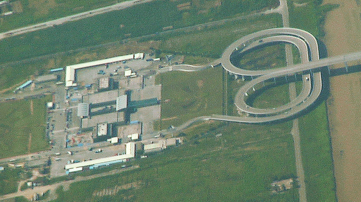
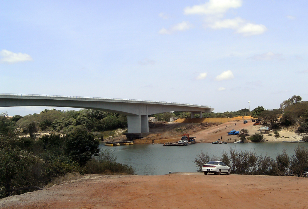
| | | | Mainland Crossovers Islands have no connecting roads to the mainland (disregarding the Channel Tunnel), so there's no conflict. But where LHT jurisdictions abut RHT jurisdictions on a mainland, there is. This happens in the Arch, both in Africa and on the Asian mainland, and to a minor extent, in South America. | | | | Border crossovers between left and right are accomplished by traffic lights or directional signs, accompanied by lane markings switching over, with painted arrows on the ground. This is similar to highway lane markings anywhere showing lanes and showing arrows for left or right turns. Some locations might use a very carefully marked roundabout (traffic circle) to disperse incoming traffic encountering the alternate system. More major crossings might have something more sophisticated, such as crossover bridges, similar to superhighway cloverleafs. | | | | China My personal experience with road crossovers at borders between LHT and RHT is minimal, and will not be increased in China. China, Macau, and Hong Kong each have their own money and visa requirements (strenuous for China, minimal for the other two). The Hong Kong-Macau connection is only by ferry, and they both have LHT anyway. While there are four border crossings between RHT China and LHT Hong Kong, plus two between China and LHT Macau, I'll be using none of them, since I'll be leaving Hong Kong by train, and then flying back later on the way home. | | | | I have no information about how crossovers are done at the four road crossings at Hong Kong/China, but do have some about Macau/China. The older crossing one is on the north side of Macau, and my information is that there is no special system there. The LHT Macau roads continue on the Chinese side to a roundabout, which then apparently disperses traffic on a RHT basis. (Since Macau is tiny, with vey little space to spare, both changeovers are on the Chinese side.) | | | | However, the newer crossing point from 1999 is on the west side of Macau and is located at the Lotus Bridge (Photo by BurnDuck, taken from a commercial airliner) over the border waterway. This location was designed for high traffic volumes, and has three lanes in each direction. Macau is off the picture to the right, as is half of the actual bridge. Here on the Chinese side are the flyover loops to change traffic direction. Follow how a car in China with RHT leaves customs at the bottom and ends up on the bridge ready for Macau's LHT, and vice versa. It's an elegant design to accomplish a fundamental task.
| | | | Thailand Thailand was never invaded, but adopted LHT to diplomatically accommodate Britain in 1826 so that Britain had a shortcut connecting LHT Singapore and Malaya (now Malaysia) straight through Thailand (and then LHT Burma) with LHT India, all of which were British. But remember that in 1970, Burma switched to RHT, making the border situation more complex for Thailand (check our map again). | | | | Thailand today is the northernmost country of the east bloc of the Indian Ocean Arch, and the only one bordering on the rest of mainland Asia. As in the Indian and African areas of the Arch, also somewhat in South America, there are many border crossings requiring changeovers, and even more since Burma's changeover in 1970. This map of Thailand will show more closely that only the border of LHT Thailand with LHT Malaysia requires no border switching, but 90% of the border does, where roads connect to RHT Cambodia, Laos, and Burma (Myanmar). | | | | This is a Thai border crossing with Laos (Photo by Mattes), in Thai and English. The traffic sign at the lower right shows no right turn, which is the difficult turn with LHT. But the most interesting sign is one you very rarely see, the X sign at the top, which is most likely also painted on the roadway ahead. It shows you that as you cross the border you, driving on the left, will cross over the X to the right, and will expect traffic that is at first facing you to also cross over, to the left.
| | | | When I was in the Golden Triangle of northern Thailand in 2010, at the tripoint of three countries, I crossed briefly into both Laos and Burma "completing the triangle" as it were. But my brief crossing into Laos was by a small long-tail boat (picture in 2010/18) across the Mekong to a market, where there were just pedestrians and no vehicular traffic, so I couldn't sense a change from LHT to RHT. Shortly afterward, my guide drove me west to Mae Sae, the northernmost town in Thailand, where I paid a small fee to walk across the bridge over the Ruak into Burma. There was plenty of pedestrian traffic, but very little vehicular traffic entering the Burmese town of Tachileik on the opposite bank, and I can't recall seeing any crossovers. I did ask the guide to walk with me about three blocks north, where we reached a traffic circle at the crossing of a major road, so I suppose that was where the change took place. | | | | | | In 2013/10, in discussing offset (half-hour) time zones, I said I'd experienced them only in Newfoundland and central Australia. Technically, on my very short walk into and out of Burma, I experienced it a third time, where Burma is one-half hour earlier than Thailand, but that made no practical difference, nor did the RHT, since I was in Burma for only 15-20 minutes. |
| | | | 1961 Sweden Since it seems that I never, ever experienced crossover traffic at a border, I'll add some additional background, where I did experience it in a car and found the unexpected, sudden change a bit overwhelming. It was just before Christmas when Beverly and I were studying in Mainz, and decided to spend the holidays with her relatives in central Sweden. We took the overnight train to Copenhagen for a couple of days, then rented a car, picked up her parents at the airport, who'd flown in from Minneapolis for the occasion, and after dinner, took ferry to Sweden. | | | | I was still an inexperienced driver, so Beverly did the driving while we were there. Not only had she driven more than me at the time, she pointed out that she'd driven a tractor in Minnesota, so that convinced me! Denmark has RHT, and both she and her parents had been to Sweden in the past, and were aware that at the time (1961) that Sweden still had LHT (it converted in 1967). As I recall, I was not aware of that, so all the more reason for her to be driving, and all the more my shock on arrival. This is obviously not exactly a mainland crossover, since Sweden is separated from Denmark by the Öresund, and the crossover took place on the Swedish side. On the ferry, cars were loaded as per RHT, and as we pulled off in Sweden, the ferry landing was floodlit in the dark winter's night. It was then that, with dropped jaw, I watched Beverly drive across the X painted on the ground to the left-hand side, all as oncoming traffic was waiting opposite us to later cross the other way to get on the ferry. That floodlit image on a winter's night is firmly implanted in my memory, so, yes, I can say I've experienced a border crossover. | | | | History of LHT & RHT We now want to see how this happened and how it all started, but we have to work with fundamental assumption. With apparently only one exception, traffic-handedness as it presents itself today started in Europe, and the colonial powers spread it around the world, each power spreading its home practice. Any traffic practices that might have sprung up by indigenous peoples around the world would have been superceded by the dictum of the colonial power. The only place outside Europe that seems to have established its traffic-handedness on its own (LHT) is Japan. | | | | Origin of LHT As much as the fact may surprise, given that RHT is more widespread today, LHT was by far the most widespread original mode of road travel. It would seem that the basis for LHT is connected both with horse travel and with right-handedness, which at first might seem counter-intuitive. A rider, probably right-handed, would want to hold the reins in his left hand so as to have his right hand free for any trouble, either from an enemy or highwaymen, so that he could draw his sword with his right hand and defend himself. In addition, keeping to the left, his scabbard, hanging on his left, wouldn't hit those passing in the opposite direction. A less violent reason would be that he'd want his right hand free to wave to friends, perhaps salute, or shake hands. Also, a right-handed person finds it easier to mount a horse from the left, and, in addition, the sword in its scabbard would be on his left, also making right-mounting easier. Therefore, the horse would best be standing on the left side of the road facing forward, while the rider mounts away from traffic.
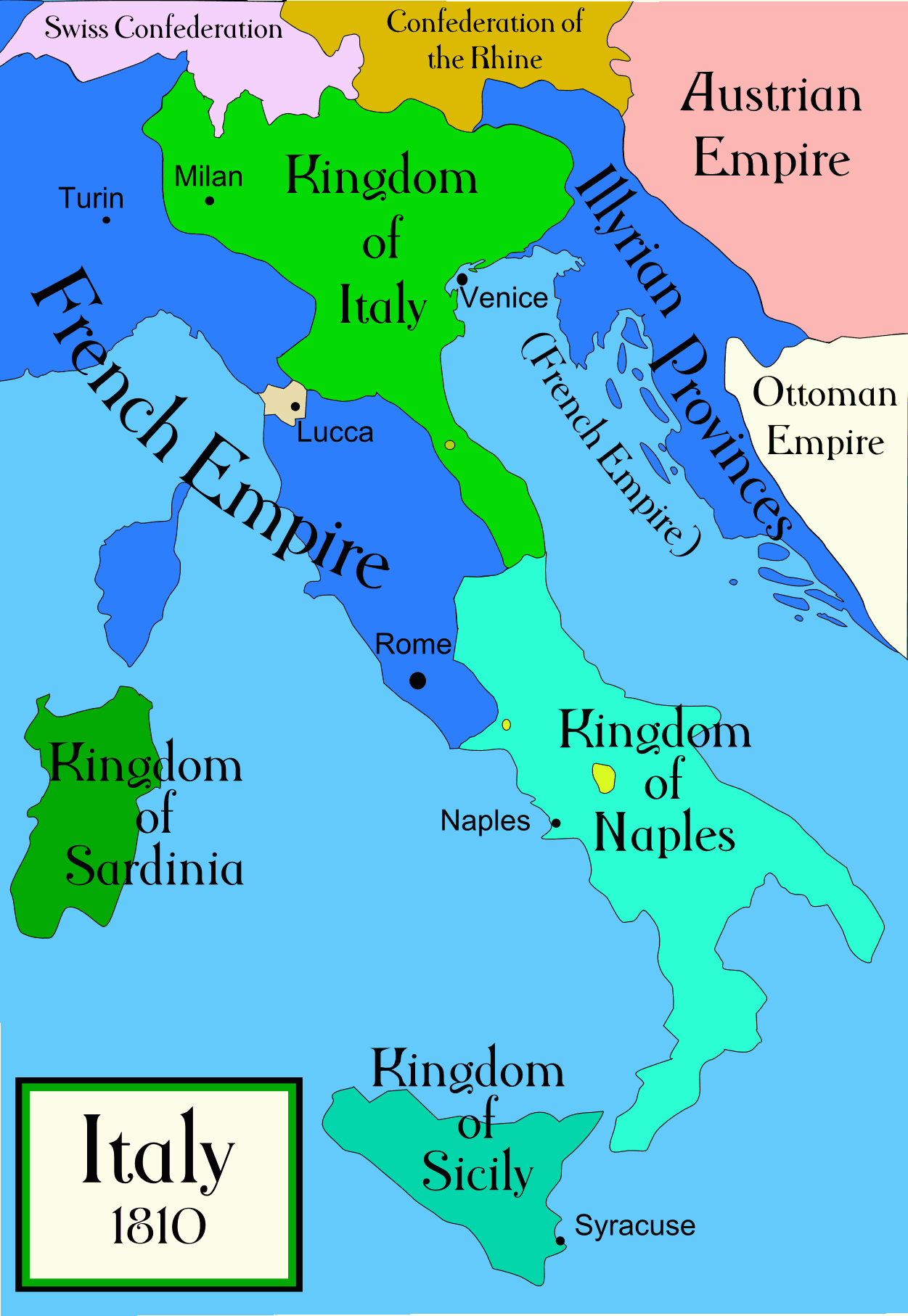
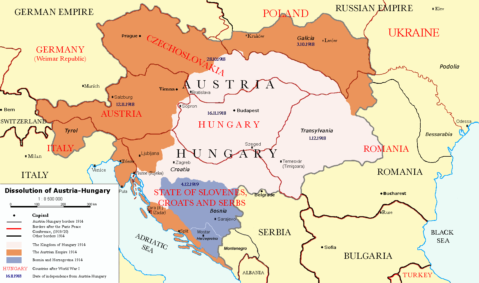
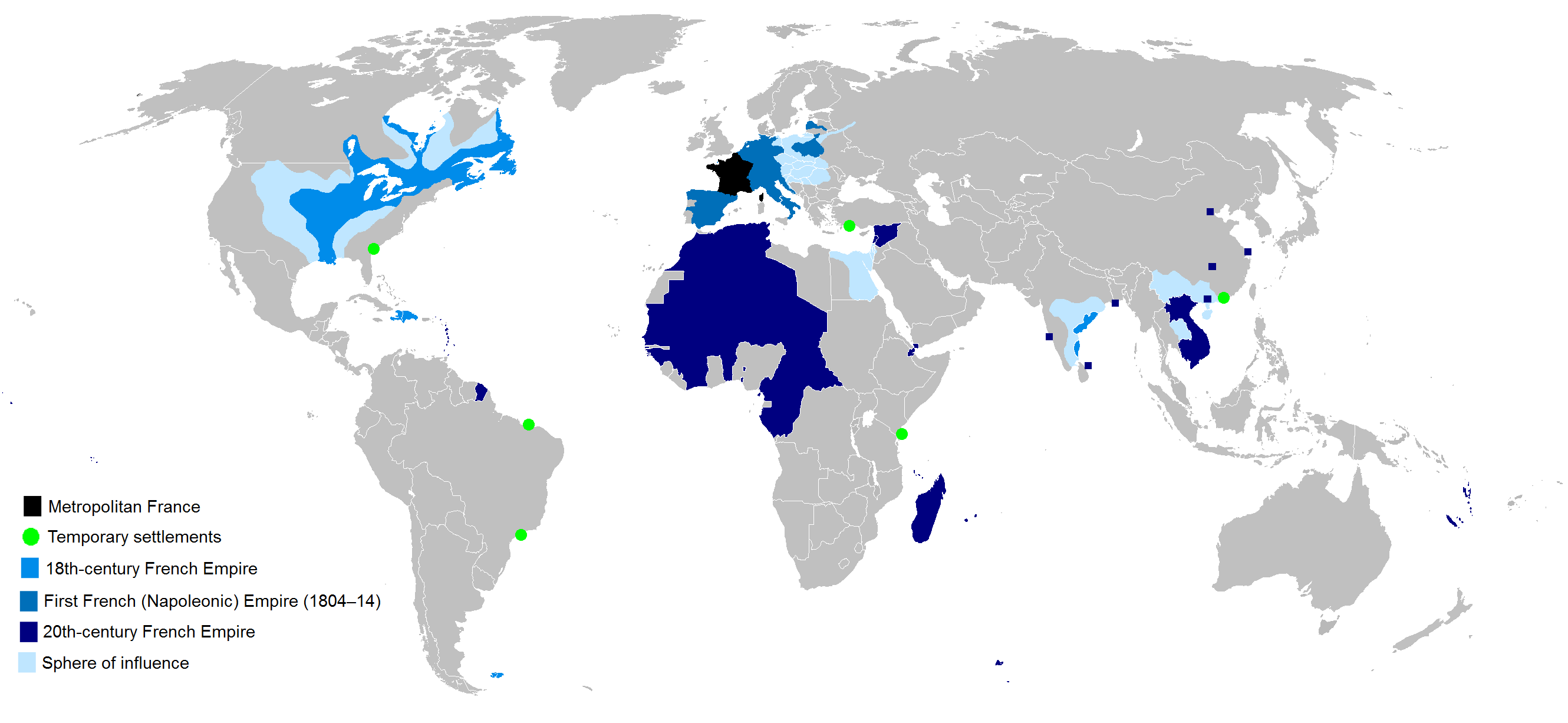
| | | | People argue which side the ancients used, the Egyptians, Greeks, and Romans, some having evidence that the Romans in Britain rode on the left and that in Turkey, they rode on the right. Others suppose that the left was more common even then, for the above reasons. But all that is really a triviality, since it's a working backward from what contemporary developments turned out to be, starting in the 1700s, when developing customs started to be codified into laws. The major reason for this was the increase in horse traffic. A statistic I found about London was that, where there had been 300 coaches in 1639, by 1771 the number had reached 1000. Also, because of the expansion of travel and road building in the 1800s, traffic rules were established everywhere. Thus it can be said that modern traffic-handedness started slowly in the 18C and became codified in the early 19C, for one side of the road or the other. | | | | Origin of RHT Before the principal force behind RHT developed in the late 1700s (for reasons explained below), RHT apparently developed spontaneously in Russia in the early 1700s, for reasons unknown, and then apparently spread to Denmark(-Norway). In 1709, the Danish ambassador to Peter the Great's court noted that there was a widespread custom in Russia for traffic to pass on the right, and in 1752, Russian Empress Elizabeth issued an edict for RHT in Russian cities. Whether related or not, in 1758, RHT was adopted in Copenhagen and in 1793, RHT spread to the rest of Denmark, which at the time, included Norway. But these countries were not the principal force behind RHT spreading like wildfire across Europe. | | | | The principal force was France, riding on a couple of momentous events in France's history, starting with the French Revolution. France, like everywhere else, had ridden on the left, but pre-revolutionary France had its notorious "Let 'em eat cake" aristocracy, and the custom developed for peasants to move out of the way—to the right—to give aristocrats the right-of-way and let them pass, even if that meant the peasants would face oncoming traffic. Eventually this became a requirement ordered by the French Crown. This point relates to our "passing lane" discussion earlier. As the left side of the road became a place for most people to avoid, the right side became more commonly used. And then came the Revolution in 1789, after which any aristocrats who still had their heads on their shoulders chose to keep a low profile and travel on the right with the peasants. With everyone on the right, that also become codified in France in the early 1790s when a RHT decree came out, parallel to Denmark's rule of 1793. | | | | There was another factor leading to RHT. During this period, there were more and more big wagons with farm products, so big that they had to be pulled by a large team of horses, in several pairs. These large wagons would have been the tractor-trailers of the era. The teamster did not have a seat on the wagon itself, but instead rode one of the horses closest to the wagon. He rode the left rear horse so he could keep his right arm free to lash the team. From his left-hand position, he'd want to see that he had clearance passing opposing vehicles, meaning the wagon had to be on the right side of the road. This is another example of right-handedness causing a change, but again, in a counter-intuitive way. | | | | Earliest European Conversions to RHT So now we're past the French Revolution, with Russia, Denmark-Norway, and France as the earliest to convert to RHT. How would it be that France would take the lead in this movement? Well, because of the second momentous French event of the period, the rise of Napoléon in 1804 (in power until 1815). Napoléon was a border-changer, to say the least, and although it's far less known—virtually unknown--a traffic-handedness changer. | | | | Napoléon's conquests across Europe spread French RHT, to a minor extent symbolically, since Napoléon's arch-rival, Britain, kept to the left, but primarily with military considerations in mind. A pro-belligerance reason he ordered his armies to stay on the right wherever they went was so that armies that confronted them, marching on their customary left, came face-to-face with the French armies and either fought them, or yielded. An anti-belligerance reason again involved right-handedness. Troops passing on the left were in a position to raise their right fists across the way against opponents marching on the other side, but keeping everyone on the right kept those right fists away from opponents. | | | | Because of Napoléon, French RHT spread to countries both occupied by him and allied to him: Belgium, the Netherlands, Luxemburg, Germany, Switzerland, and Poland, bringing French RHT to the borders of RHT Russia and Denmark/Norway. It's also interesting that he brought RHT to only parts of Spain, Italy, and Austria. We'll examine all this with some maps. | | | | Remembering that Napoléon's years in power were 1804-1815, this is a map of the départements of the Empire of France in 1812 (Map by Andrei nacu). Click to enlarge to inspect how France had annexed territories to its north to include what are today the Benelux countries, and even northern Germany, so that both Hamburg and Lübeck were in France. Denmark/Norway at the time came down to abut these cities, bring areas of RHT together. To the east, were allied states in present-day Germany and Poland (through which Napoléon invaded Russia) bringing RHT to the border of RHT Russia as well. | | | | The area to the south is even more interesting. Notice that France was extended to include part of today's Spain down to Barcelona—actually, this is Catalonia that it annexed, which also got RHT. Spain of course maintained its LHT. Post-Napoléon, Spain was one of the countries we mentioned that had what you might call a de facto "local option", this area, including Barcelona, with RHT, and the rest, including Madrid, with LHT. It wasn't until over a century later, in 1924, that the rest of Spain converted to RHT, making the country uniform. It would seem that it was the automobile age that caused so many changes in the early 20C, which began to end this division on the Continent that had started a century before. However, since the Madrid Metro was built in 1919, to this day it still runs on the left. | | | | Now look right on the map, to Italy, where most of western Italy, with one little break, is also part of France, including Florence and Rome! Still, the information I find says that RHT became established only in the late 1890's, but I'm going to guess that there was a remaining heritage of French influence. The first Italian Highway Code of 1912 established RHT, but with loopholes. Cities with trams, for instance, could retain LHT as long as they posted warning signs at their city limits, which put Italy as well into a situation of de facto local option, with major cities with LHT and the countryside with RHT. Rules were further tightened in 1923, but Rome, plus the northern LHT cities of Milan, Turin, and Genoa still retained their LHT. Rome finally moved right in 1924-5, and Milan was the last Italian city to do so, in 1926. | | | | We next come to the part of Napoléon's French Empire called the Illyrian Province, named after the Latin name for the area that later became Yugoslavia. This smaller map makes it perfectly clear that all the areas in blue were part of France at the time, but now go back to the Illyrian Province on the bigger map. This was a short-lived province that only lasted between 1809 and 1816, obtained by Napoléon by a military win, but then later followed with a military loss. As you can see, its départements were never fully established. This gives an indication of RHT moving beyond the Adriatic, but most important is to note for our purposes that its northernmost area, labeled Caranthie in French, is in today's Austria the southern Land (Province) of Kärnten (Map by TUBS), or Carinthia in English. Go back to the main map. Austria-Hungary, that huge country, was never invaded by France and retained its regular LHT into the 20C, although Kärnten already had a heritage of that from France. More about Austria-Hungary later.
| | | | Later European Conversions to RHT While as we said, regulations had started slowly in the 18C and became codified in the early 19C; wholesale changeovers to RHT started to take place throughout the 19C and, surprisingly to me, very extensively well into the 20C, and even into the 21C (Okinawa, Samoa). Go back to our master map from the beginning and let's look at what happened to the parts of Europe we haven't already discussed. | | | | But first, as we move further into the 19C, we have something almost humorous about France, the leader of RHT. French trains today drive on the left. Why? Because the first lines were built by British engineers. That just seems so ironic, it makes you want to smile. LHT is also used on the RER (Réseau Express Régional), the modern suburban train system of Paris, although the Paris, Marseille, and other Métro systems have RHT. | | | | But the story gets even better. France brought RHT to Germany. Germany also built its railroads using RHT, including in Alsace-Lorraine. When that area came back to France, its rail system was opposite the French national rail grid. It remains so, and trains require a crossover. Well, they would anyway, if they continue into Germany. These are just the little ironies of history, but it shows why we're not treating the confusing rail systems here, just mentioning special cases. | | | | So far in our discussion, much of the Continent has moved to the right. Portugal wasn't involved with France, so it remained with LHT, as did the adjacent parts of Spain, for a long period of time. As we said, western Spain converted in 1924, giving Portugal an impetus to do so, and it converted to RHT in 1928. With this change, the entire western part of the Continent had RHT. | | | | We've been holding off on the discussion of Austria-Hungary (Map by P. S. Burton) because it retained LHT to the very end of its existence, as did all of the successor areas shown on the map after Austria-Hungary was broken up after WWI. While all these areas have RHT today, as does the whole Continent, I have information on only the major changes. First, when Poland was reestablished as an independent state in 1918, the areas taken from Germany and Russia, both already with RHT, were supplemented by Galicia (on the map) taken from Austria with LHT. Galicia switched to RHT c 1924. | | | | But the three major countries arising from the breakup waited far too long, well into the 1930's to do the switchover, and the results had to have been unsettling. Austria had started earliest, and decided, rather surprisingly, to do it piecemeal. It started in 1919 by converting the westernmost province, Vorarlberg, to RHT, and added more in 1930 and 1935 until the western half of the country had RHT and the eastern half, including Vienna, still had LHT. Then on 12 March 1938 Hitler invaded and annexed Austria and the rest of it was converted to RHT under pressure later that year, without adequate planning. Motorists were in confusion, since signs hadn't been moved to the other side of the roads in time. In Vienna, they couldn't change the trams over in time, so while cars moved to the right immediately, trams kept running on the left for several weeks. | | | | It was no better in Czechoslovakia, which planned to introduce RHT on 1 May 1939 (How ironic! The war year!), but Bohemia and Moravia were invaded and annexed on 15 March, so the changes took place that month under German occupation. Slovakia had already decreed RHT in late 1938, with conversion starting in 1939 and lasting until 1940-1941. | | | | Hungary, too had planned to change in June 1939 but postponed it, and RHT was finally introduced in the latter half of 1941. One has to reflect how difficult it must have been to make these traffic changes just as your country has been occupied and a world war is starting. The traffic legacy of Austria-Hungary proved to be a very troublesome matter, because too many places waited too long to make the change. | | | | We saw on earlier maps that the Ottoman Empire had still reached up to Austria-Hungary, which was true into the 20C, until it retreated to the present European border of Turkey. Because of the extent of the reach of the Ottoman Empire, and because its traffic policies in the latter half of the 19C, when its army laid down formal traffic rules, were strongly influenced by France and Germany, both southeastern Europe, and all of the Middle East have RHT. | | | | This leaves us on the Continent with only Sweden and Finland, since the Baltic states were part of the RHT Russian Empire. Sweden had actually had a short period of RHT from 1718 to c1734, even before Denmark and Norway had switched to it, but then went back to LHT in 1734 and kept it beyond the middle of the 20C. Finland was ruled by Sweden until 1809, and therefore had LHT. In that year, it became a Grand Duchy of Russia, which permitted it to keep its LHT until 1858, at which time Finland had to convert to Russia's RHT. | | | | Sweden finally converted to RHT at the very late date of 1967, making it the very last country on the Continent to convert. We will have a complete section at the end dealing with how that was accomplished. Still, trains in Sweden continue to run on the left, except in the extreme southwest of the country. Just as trains in eastern France have to switch over from RHT to LHT, trains in Malmö and its region keep to the right, in coordination with the RHT trains of Denmark, to which they're connected by the Öresund Bridge. There's a flyover-type crossover north of Malmö. | | | | The next year, 1968, Iceland followed Sweden and switched to RHT at 6AM on 26 May. It had planned to change in 1941, but WWII delayed that 27 years. Similar to what we'll see Sweden named the changeover day, Iceland called it H-dagurinn, short for Hægri dagurinn, which translates as R-day, short for Right day. | | | | LHT Remaining in Europe The first legal reference to LHT in Britain was in regard to increasing traffic congestion of horse traffic on London Bridge, when the Lord Mayor of London ordered that traffic should keep left; I've seen both 1722 and 1756 cited as to when that happened. LHT was made mandatory in Britain (which still included Ireland) in 1835. In the late 1960's the question of RHT was studied again, and rejected as too costly, but legislation was enacted requiring all road junctions to be designed and built for easy conversion to possible RHT. While this has not happened, the legislation remains in place. | | | | It has to appear amazing that all Europe once had LHT and it's almost all gone. In actuality, besides Britain (including the Channel Islands of Jersey and Guernsey, plus the Isle of Man—check our map) and Ireland, there are two other jurisdictions in Europe with LHT, both islands, and in the Mediterranean. On our map, below Sicily, find the blue dot for Malta, and further east, the blue outline of Cyprus, both former British colonies. | | | | From the above, I think we can agree that France has to be considered the RHT-Team Captain, since it furthered that goal since the French Revolution, which, on reflection, also gave us the metric system. However, it's only by default that Britain takes on the role of de facto LHT-Team Captain—although it has dispersed LHT around the world—because all the other European members of the team have defected to the opposition, leaving Britain as the major remaining team member, and thus, by default, LHT-Team Captain. | | | | Keep on checking our map. We've said that colonial powers spread their own ways around the world, and mentioned so far only the Ottoman Empire spreading RHT from SE Europe to the Middle East. Russia did the same as it expanded across Siberia to the Pacific, and also in its influence on Finland. Denmark would have brought RHT to the Faroes and Greenland, and logically to Iceland as well, but I can't explain why Iceland had had LHT until recently. | | | | RHT & LHT in Anglo-French North America Continuing to define North America, that is, Anglo-French North America, as the area above Mexico and Cuba, we come to an apparent anomaly. We can see that dot below Newfoundland for Saint-Pierre and Miquelon, totally French with RHT, but how do we explain that both the United States and Canada, both former British colonies, have defected to the RHT team as well? | | | | The answer to both questions shows why it's good to visualize the areas as Anglo-French North America. The French were there first, in New France. As for the United States, remember that Québec originally stretched down to the Mississippi at Saint Louis, and beyond that was Louisiana (as in the Louisiana Purchase) which reached down to New Orleans. Now it's true, that the thirteen original colonies huddled on the east coast had had LHT. If you picture The Boston Post Road and Albany Post Road leading out of Manhattan to the destinations in their names (2011/7), do picture LHT on them, as well as on Jamaica Avenue leading from Fulton Ferry to Jamaica on Long Island (2011/9). When you picture Paul Revere and some 40-odd riders fanning out from Boston to Lexington and Concord in 1775 (2011/21), picture them going down the left side of the road if you want an accurate image in your mind. | | | | So what set off those thirteen original colonies after the American Revolution (1775-1783) to adopt RHT? Part of it was certainly a "We're not British!" attitude, but that alone might not have done it, and it didn't happen immediately afterward, either. However, France was an ally of the United States during the Revolution, and as years went by, the highly-respected Marquis de Lafayette suggested that RHT, which had become a symbol of class equality ("Égalité!") in France, would be appropriate in the post-revolutionary United States. Thus, the first RHT law was passed in Pennsylvania in 1792 and applied to the Philadelphia and Lancaster Turnpike. New York State switched in 1804 and New Jersey in 1813, and the practice eventually became national. Then, beyond the British and French regions, when the US expanded to former Spanish and Russian territory, even Hawaiian territory, RHT in those places was already in force. | | | | But how about Canada, whither so many Loyalists had fled? Surely Canada would maintain traffic as in Britain? Picturing Canada as so British again flies in the face of the fact that Canada, that is, Canada-on-the-Saint-Lawrence, was a French entity that was taken over by the British. Both Lower Canada (Québec) and Upper Canada (Ontario) already had RHT since French rule. As of Confederation in 1867, therefore, Canada became one of those de facto "local option" countries like Spain or Italy, since the Atlantic Provinces and British Columbia had had, and continued, the British practice of LHT. This situation continued into the 20C. | | | | When Manitoba joined the Confederation in 1870, and both Saskatchewan and Alberta in 1905, all three adopted RHT, but Canada still had two driving systems. That finally started to change, to conform with the practice of not only the rest of Canada, but with the adjacent United States. British Columbia started, by adopting RHT in early 1922. New Brunswick changed in late 1922, but Nova Scotia didn't change until 4 ½ months later, in early 1923, which had the affect of moving the changeover area to the NB-NS border for that period. Prince Edward Island didn't change until early 1924, but it being an island, that didn't cause any border problems. At this stage, all of Canada and the US had RHT. Do you accept that statement? | | | | If you don't see that that statement is indeed correct, then you're forgetting that Newfoundland was not part of Canada in the 1920's but its own Dominion, and it maintained LHT. When you pictured Canadian and American forces at the WWII gun batteries at Cape Spear in the last posting, you have to realize that they both had to conform at the time to Newfoundland LHT practice. Finally, Newfoundland joined Canada in 1949, and in preparation, adopted RHT two years earlier, in 1947. Thus it wasn't until almost the mid-20C that LHT completely disappeared from Anglo-French North America (we're not counting the Caribbean here). | | | | RHT & LHT in Latin America & the Caribbean Only the French settlements in this area, such as French Guiana, Haiti, Saint-Martin, Guadeloupe, and Martinique, used RHT. Otherwise all the other colonial powers originally instituted LHT, the Spanish and Portuguese, and also the British and Dutch in their few settlements. I don't have details as to when most of these changed over, particularly the large part of the Spanish settlements from Mexico to Chile, but I'll provide what I do have. | | | | Brazil changed to RHT when Portugal did, in 1928. Up until then, it had developed both traffic patterns, apparently one of the local option areas. Surprisingly, it was during the planning of the Pan American Highway from Alaska to Cape Horn in the 1930's that caused a number of changes to those Spanish-speaking countries that hadn't already changed earlier. This strikes one as odd, since today we don't really hear very much about that highway. Highway planners decided that uniformity would be necessary, and chose the more common RHT. Based on this, the few Spanish-speaking countries still with LHT converted, Panama in 1943, and Argentina, Uruguay and Paraguay in 1945. Also, British Honduras, now Belize, went to RHT in 1961. | | | | When the Netherlands was annexed by Napoléon to France and changed to RHT, that didn't affect its colonies, which retained LHT. Therefore Guyana (ex-British) and Suriname (ex-Dutch) are the only mainland countries, not only in South America, but in ALL the Americas, that maintain LHT (check our map). Both of them are separated from their neighbors by large rivers, and the inland south is sparsely populated with no crossings either, so crossover traffic has not been an issue. | | | | However, the first bridge crossing one of these rivers in southwestern Guyana opened in 2009, when Brazil, eager to reach sea ports on the Caribbean, built the Takutu River Bridge (Photo by JodyB) at Lethem, Guyana. There is now a changeover system, on the Guyana side, where one lane of the bridge's access road passes under the other. While Brazil expects its vehicles will be able to drive all the way to the coast, it's limiting Guyanese right-hand-drive (RHD) vehicles to go no further into Brazil than the border town of Bonfim, just beyond the bridge. This bridge is the only crossover border crossing anywhere in the Americas. | | | | While Suriname didn't change, all the Dutch islands in the Caribbean do now have RHT, as do the Spanish-speaking and French-speaking ones. Only English-speaking islands use LHT, such as Barbados, Jamaica, Trinidad & Tobago, and many others (check map for blue dots). A bit further afield, this is also true about the Bahamas, Bermuda and the Falklands. | | | | Portuguese, Dutch, German Colonies We haven't shown maps of the Ottoman Empire reaching the Middle East or the extent of the Spanish Empire in the Americas because, although they were large, they were each contained in one area. Much more revealing now for the rest of the world, Africa, Asia, and Australasia, will be maps of the highly dispersed British and French Empires, the cornerstones of this exercise. However, first, let's look at three smaller, but equally dispersed colonial empires, the Portuguese, Dutch, and German Empires. | | | | This map shows the maximum extent of the Dutch Colonial Empire (Map by red4tribe). It's anachronous, in other words, represents different time periods all put together on one map, and so it never was this size all at once. The dark green represents the Dutch West India Company and the light green the Dutch East India Company. Let us repeat, that, when the Netherlands went to RHT, it's empire did not, which is why Suriname in South America still has LHT, and why the Dutch islands in the Caribbean are an oddity for having changed to RHT. Note the colony of New Netherlands in the US. It had LHT, so when it was taken over by the British, no change was necessary. Note the Dutch Afrikaans settlement in what became South Africa—ditto. Note the Dutch interests in Ceylon and India—ditto. As we mentioned in 2009/43, the Dutch were in Taiwan from 1624 to 1662. When others took over, including adjacent southern China which had LHT, and Japan, the same, any LHT customs the Dutch may have left didn't have to be changed. Finally, the most important, the East Indies, which today is Indonesia. It has LHT today as a remnant of Dutch colonial rule starting in 1596, information which to me is most logical, and which I found from two sources. However, a third source says its LHT is of British origin, instituted by Sir Stamford Raffles, founder of Singapore, whose name is also that of the famous hotel, during his tenure in the Dutch East Indies between 1811 and 1816. I think that is less logical, and at most, he might have codified customs that were already in place under the Dutch. Make your own decision. | | | | This map shows Portuguese Colonial holdings (Map by The Ogre), but is synchronous, limited to the 20C. (Note that the dates on this map show independence, not traffic change.) It therefore leaves out Brazil, which became independent from Portugal in 1822, but still went to RHT in 1928 when Portugal did, including the Azores and Madeira, visible on the map. Differently from the Netherlands a century earlier, Portugal had its colonies either keep LHT or go do RHT, according to local needs, which why its former colony of Brazil aligned itself with RHT in the Americas. | | | | Look next at ex-Portuguese Africa. The Cape Verde Islands, São Tomé, and other small locations in the west, went to RHT in 1928, either because they were islands or because of nearby French influence. But the large colonies of Angola and Mozambique are of particular interest. Mozambique, in the east, retained LHT since it was surrounded by British colonies. Angola, which also bordered LHT areas, bordered RHT areas to the north, and decided to go that route instead in 1928. | | | | Look at India. When Goa and other territories were taken over by India, they simply retained LHT, the same as India. Move east, and now we get part of the answer to the initial purpose of this exercise, as information for the upcoming China trip. Macau, which went to China in 1999, retained LHT, because the adjacent part of China also had LHT at the time. | | | | The oddest situation here deals with East Timor on the right of this map. It had LHT until 1928, but when Portugal changed over, contrary to all logic, East Timor went to RHT as well, even though that created border crossing problems with the other half of the island, West Timor, and was out of line with all the surrounding islands of Indonesia. RHT was the rule from 1928 to 1976, shortly after Indonesia invaded. At that time, Indonesia changed East Timor back to the original LHT. Even after East Timor finally achieved independence in 2002, it this time wisely retained its LHT, in conformity with its surroundings. | | | | We now come to a map of the German colonial empire (Map by Andrew0921), shown here in 1914, just before it was dismantled by the Allies in WWI. It had had RHT, like Germany did. At that point, former German territories in West Africa, such as Kamerun and Togoland, were divided between Britain and France, and a number of borders were shifted. We can assume the British instituted LHT in its new territories. | | | | More interesting is what happened to German East Africa. Belgium, in the adjacent Congo, received the two small northwestern areas of Ruanda-Urundi, today's Rwanda and Burundi, but Britain got all the rest, and it became Tanganyika, most of today's Tanzania. But this was a great coup for Britain, since this was the missing link in the chain of British possessions stretching from South Africa to Egypt, the famous "Cape to Cairo" route. This means that what had been RHT German territory remained that in the Belgian areas, but became LHT in Tanganyika>Tanzania. However, apparently there is discussion today in Rwanda about going back to LHT to be in conformity with nearby areas. | | | | Jurisdiction over German Southwest Africa was given to South Africa, which changed the area to LHT, which it retained in 1990 as an independent Namibia. While it borders RHT Angola, it chose to continue conforming to its LHT neighbors. | | | | Look over in the Pacific. German New Guinea and adjacent islands went to Australia and are in the LHT world. German islands, the Marshalls, Carolines, Marianas, Palaus, went to Japan, and ditto. But German Samoa was assigned to New Zealand, yet maintained RHT for almost a century, and it was still in force when I was there (2009/5). I discussed the German history of Samoa in that posting and made reference to a German monument. Still, I remember the woman that drove me around lamenting that the Samoan government was thinking about switching over to LHD, and her steering wheel (and everyone else's) would then be on the wrong side. I left Samoa on 1 February, and so it happened just seven months later in 2009, on 7 September, that Samoa adopted LHT to be in conformity with New Zealand, Australia, Japan, and so much of that area. | | | | French & British Colonies Now that we've seen other empires, we can go back to our Team Leaders, France and Britain, and their effect on traffic-handedness in Africa, Asia, and Australasia. This is an anachronous map of French territories (Map by Kayac1971) over the centuries, to which France would have spread RHT. Note Europe, where it started, and also North America, to see the extent of New France. You can also find Haiti and French Guiana. Then look to Asia, where French Indo-China was a colony, with RHT. But most interesting is the French influence on Africa. Curiously, its cultural influence was strong enough on Egypt, going back to Napoléon, so that, even though Egypt became a British colony, French RHT has been maintained there to this day. But British companies established the rail system, so trains run on the left. | | | | Madagascar was a French colony, which explains why it has RHT in the middle of the Indian Ocean Arch of LHT. But it’s the bulk of French presence in northwest Africa that's most impressive. Yet notice how there are so many "holes" in its continuity, where there are other countries along the coast. We can refer back to this in a moment. | | | | This is a map, also anachronous, of British territories (Map by The Red Hat of Pat Ferrick) over the centuries. The remaining present British Overseas Territories are underlined in red. We see in Europe and the Americas exactly what we've been discussing. But let's concentrate first here on Africa. | | | | Look on the French map at West Africa. You'll see six spaces that aren't French. The first one in the north is Western Sahara and the small sixth one is Equatorial Guinea, both already with the same RHT as the French territories. The four in between correspond to the four on the British map, and all converted on the following dates to RHT because it was the most common in West Africa. North to south they are (The) Gambia, 1965; Sierra Leone, 1971; Ghana (ex-Gold Coast), 1974; Nigeria, 1972. | | | | From the British map, you can see the present West LHT Bloc of the Indian Ocean developing from South Africa to Kenya, including ex-Portuguese Mozambique and the conversion of ex-German Namibia. (The others in this bloc are Lesotho, Swaziland, Botswana, Zimbabwe, Zambia, Malawi, Tanzania, Uganda). But what happened to northeastern Africa with the Cape to Cairo route? Well, Egypt was already under French influence, Ethiopia changed to RHT in 1964, and the Sudan (with today's South Sudan) changed in 1973. This was in accordance with the other countries of the Arab world, including in the adjacent Middle East, where South Yemen (ex-Aden) changed in 1977, especially since North Yemen already had RHT. | | | | On the British map, compare Australasia with the East LHT Bloc on our main map, and British influence will be obvious on New Zealand, Australia, Papua New Guinea, Malaysia (ex-Malaya, etc), Singapore, Fiji, Tonga, Tuvalu, Nauru, Kiribati, Solomon Islands. You can see why Samoa (ex-Western Samoa) felt it advisable to switch to LHT, although Vanuatu (and others) do have RHT. | | | | Australia has had LHT since the first road was built in New South Wales in the early 19C and Governor Lachlan Macquarie decided to follow the British practice. Note as well that Indonesia does have three land borders, with Malaysia, Papua New Guinea, and East Timor, but since East Timor went back to LHT, that practice is universal on the archipelago. | | | | We've discussed Burma and ex-French Indochina, but the Philippines are also in red on our main map. They had had LHT through the first part of the 20C, but the United States introduced RHT on the last day of the Battle of Manila in 1945, to facilitate troop movements. However rail traffic stayed on the left until the Manila Metro was built in 1984 and 1999 with RHT, after which the national railways switched as well, in 2010. | | | | Moving on the British map to South Asia and continuing to compare it to the main map, we see the basis for the North LRT Bloc developing. After the defection of Burma to RHT in 1970, this bloc consists of India, Sri Lanka (ex-Ceylon), Pakistan, Bangladesh, Bhutan, and Nepal. Afghanistan went to RHT in the early 1950s. | | | | The last point on the British map is ex-British Hong Kong, as well as ex-Portuguese Macau, both with LHT, in spite of the fact that China has RHT. While tiny Macau depends in many ways on less-tiny Hong Kong, including re-importing from Hong Kong right-hand drive cars that Hong Kong had itself imported, why did it make sense for them to have LHT early on in the first place? | | | | China had been one of the countries with both kinds of traffic, like Spain, Italy, Brazil, and Canada. In the late 19C northern provinces near Beijing such as Shandong had RHT under American influence and southern provinces such as Guangdong and Shanghai had LHT due to British influence. Guangdong ("Canton Province"), directly borders both Hong Kong and Macau, so all three uniformly had LHT, and by the 1930's, all of China had LHT. After WWII, the Nationalist Government instituted RHT in 1946, but neither Hong Kong or Macau went along with it, resulting in the necessary crossovers at the borders today. This really makes very little sense, especially in the light of the changes in Africa, East Timor, and Samoa, to conform with one's neighbors. Taiwan had LHT under the Japanese, but changed to RHT in 1946 along with the Chinese mainland. | | | | Japan has always had LHT, a practice dating from the Edo Period (1603-1867). This is when the samurai, who wore their swords on the left, passed other samurai on the left to avoid knocking swords. This is half of the same explanation given for the European practice, and I've seen nothing said that they wanted their right hands free and near any opponent for a good fight. But that doesn't mean it isn't so. It wasn't until 1872 that the custom of LHT more or less became official, and not until 1924 that it was written into law. British engineers helped Japan as well with railroad building, but both had LHT so there was no conflict. | | | | When LHT Okinawa was ruled by the US after WWII, RHT was introduced. After it was returned to Japanese control in 1972, LHT was reintroduced in 1978. Korea had been under Chinese influence in the 19C, the part that had LHT, and so Korea adopted it as well, and when Japan annexed Korea in 1910, LHT was maintained. In 1945, Soviet forces occupied the North and American forces the South, and both implemented their customary RHT, which continues in both South Korea and North Korea today. | | | | Now that we've reviewed everything, take another look at our main map and try to comprehend why, if LHT came first, there's so much RHT today uniformly around the world, confining LHT to the three blocs—also quite uniform among themselves--around the Indian Ocean, plus Japan, the Caribbean, and the British Isles. | | | | Sweden's Changeover in 1967 To close, let's take a look at how the most recent change took place in Europe just four years short of a half-century ago, when Sweden adopted LHT in 1967. The reason for the changeover was obvious, since everyone else on the Continent already had RHT. While about half of Sweden borders water, and, while the land border with Finland is in the remote north, the land border with Norway is extensive, and busy. Another factor is one we mentioned earlier, that most Swedes before the change already drove left-hand drive (LHD) vehicles, in other words, had the steering wheel on the wrong side for LHT, but ideal for RHT. But before the change, that meant that there were a lot of accidents on two-lane highways, with cars trying to pass others, and with people pulling out from parallel parking places. Buses and trams also had to be reconfigured, but we'll deal here with how the change affected private vehicles and the physical adjustments to roads. | | | | The changeover was set for early morning on Sunday, 3 September 1967, which was called Dagen H, just as Iceland the next year called its changeover H-dagurinn. In Swedish, dag is "day" and dagen is "the day", so it seems to mean H-Day. But why H? Well, vänster means "left" and höger means right, so they were switching from vänstertrafik to högertrafik. Therefore, Dagen H is more accurately R Day. I remember at the time seeing a large Swedish commemorative postage stamp saying HÖGERTRAFIK. This is a an approximate recreation (the font is apparently different) of the rather clever crossover logo (Image by Umberto) that was used throughout Sweden saying that 3 September 1967 was Dagen H. | | | | But there was another consideration: headlights. This is a view of the low-beam light pattern for RHT (Image by cflm). There is a long seeing range in the right lane and a short cutoff on the left, so as not to blind oncoming drivers. If cars had kept their old headlights set for LHT, after the changeover the light pattern would have been on the wrong side, possibly blinding oncoming drivers. Therefore, as part of the funding for the program, the government provided the proper new headlights for everyone. But how to install them at the right time? They had to be installed in advance, but then they would have been wrong for driving before the changeover. The solution was to provide new headlights with sticker labels on them (Photo by Scheinwerfermann) that blocked the part of the lens that would have incorrectly illuminated the right side of the road before the changeover, but which was to be removed at the time of the changeover. The label says "Do not remove before the 3 September 1967." | | | | When Dagen H arrived, all non-essential traffic was prohibited from the road for five hours, from 1 AM to 6 AM, or four hours before the 5 AM changeover time and one hour after. In big cities, such as Stockholm and Malmö the ban was much longer, from 10 AM Saturday until 3 PM on Sunday, to allow work crews to reconfigure intersections. This was so that the police, assisted by the army, could rearrange all traffic signs. | | | | All vehicles on the road at that time of the morning had to come to a complete stop at 4:50, then carefully change to the right-hand side of the road—just like in the logo—and stop again for a while to get the feel of the right-hand side of the road, before finally proceeding at 5:00. In addition, a very low speed limit was set, which was gradually raised in stages over the next month. Just imagine the care and caution shown here as compared to the rushed changeover in places like Austria in 1938. | | | | We'll end with a YouTube video showing the Swedish changeover from left to right in 1967. It's a good video, but at 13:04 is too long, so skim ahead as appropriate. | | | | | | ● 00:01 – Dagen H logo, then how the old LHT days used to look
● 05:50 – police and army practicing RHT on a closed back road
● 07:34 – sticker labels removed from headlights
● 08:06 – RHT!!!!
● 11:15 – cars confused about keeping right, especially the second car seen
|
| | | |
| |
|
|
|

