|
Reflections 2013
Series 13
July 24
Atlantic Isles IX d: Avalon's Conception & Trinity Bays
| | Avalon's Conception & Trinity Bays The last stop on this trip was a revisit to the capital of Newfoundland and Labrador, Saint John's, where I stayed 3 ½ days and four nights. That adventure, including nearby coastal drives north and south, will be on the next posting. However, I had planned that on one of those days, I wanted to drive off somewhere, despite the long driving distances in Newfoundland that are unexpected by the unwary (as we had been in 1984). For instance, I thought of going back to the pretty town of Trinity (Photo by Tango7174), way out on the Bonavista Peninsula, two peninsulas west, after which Trinity Bay was named, but it's a three-hour drive one-way, so it wasn't a day trip. I thought I'd better stay this side of the isthmus and stick to Avalon. Use this map of the Avalon Peninsula (click):
http://www.walds.org/newf2002/maps/av700.gif
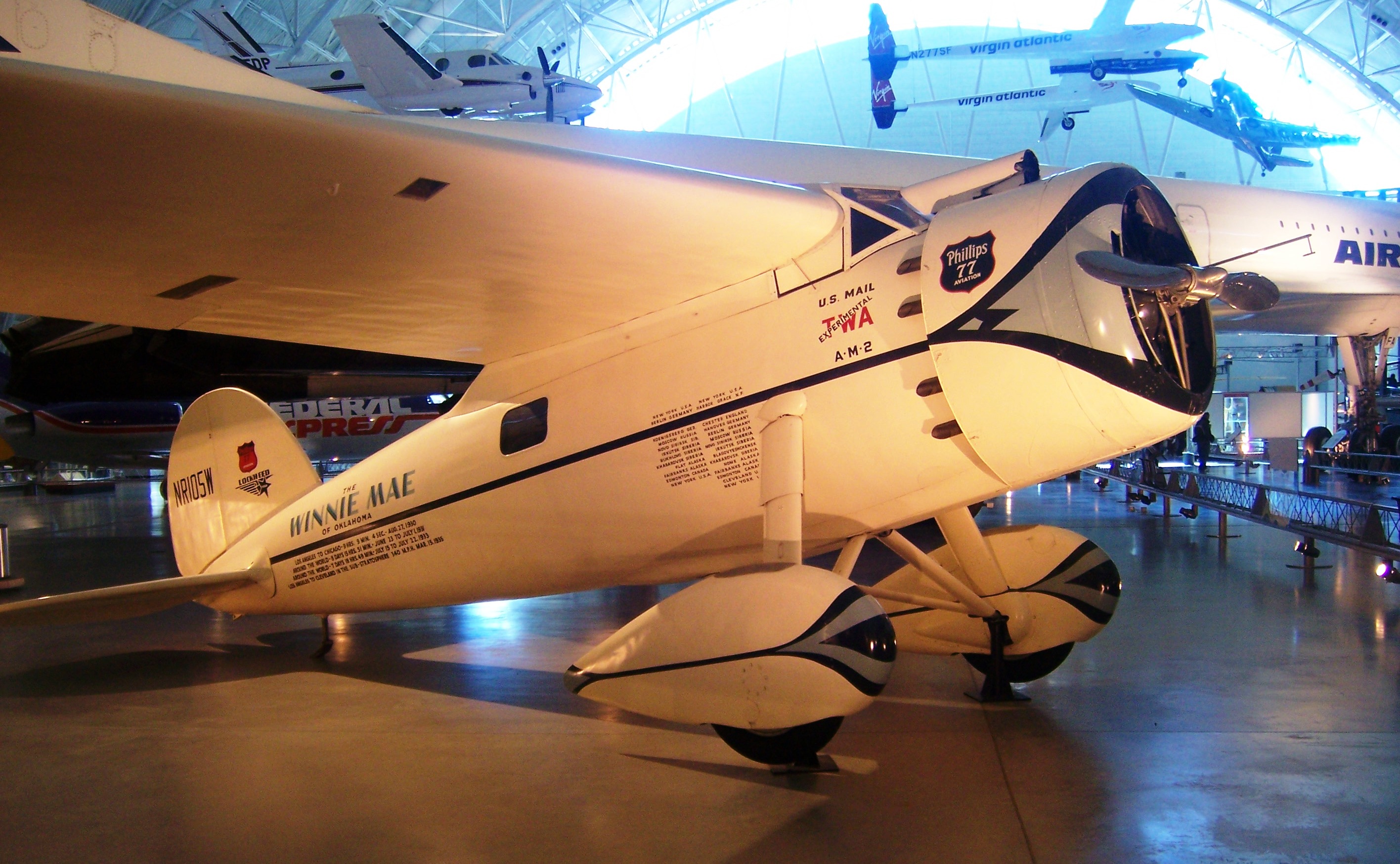
| | | | The two peninsulas to the south, separated by their bays, were rather distant, and nothing there particularly attracted me, so I decided to stay on the two northern peninsulas separated by Conception and Trinity Bays (the town of Trinity is further out on its peninsula than this map shows). I felt the 1 ½-hour drive one peninsula west to revisit the historic cable station at Heart's Content would fit in very nicely, and defined the trip in my mind as a drive to Heart's Content. However, I discovered ad hoc and at the last minute—serendipity again—a number of interesting new stops on the way to Heart's Content and back around both Conception Bay and Trinity Bay, every one of which was totally new to me, which made for a satisfying drive, and I now am defining this drive instead as a visit around the shorelines of the two bays. | | | | Go back to our above map of record to see just where our drive will take us on our day trip. I had decided against going south, but for a point of reference, look down the east coast of Avalon and find Ferryland, connected with Lord Baltimore's Avalon. But then instead trace our present route from Saint John's down through Conception Bay South and circle around Conception Bay at Holyrood until you find our first real stops, at Brigus and Cupids. Continue around to Harbour Grace (you can also find Bristol's Hope), after which we'll cut across this peninsula to Heart's Content on Trinity Bay. For later reference, note how deeply Trinity Bay cuts into the harbor at Heart's Content, and also find Bull Arm and the town of Sunnyside across Trinity Bay, right next to the isthmus. After Heart's Content, we'll pass through the similarly named Heart's Desire and Heart's Delight, and no one wants to miss visiting Dildo. From there, it's a quick run to the Trans-Canada Highway back to Saint John's. As mentioned, non-stop driving time one way is 1 ½ hours, so it makes a nice day trip. Get in the car. I'll drive. | | | | Reflecting the international nature of early arrivals in Newfoundland, the two bays we'll be visiting were both named in Portuguese. Conception Bay appeared on early Portuguese maps as Baía da Conceição and was probably named for the Feast of the Conception on 8 December. The town of Trinity was named by a Portuguese explorer as Trinidade, and Trinity Bay was named after the town. He arrived in 1501 on Trinity Sunday, which falls in May or June. | | | | CBS I drove through the town of Conception Bay South, commonly called CBS, which was formed in 1973 by the amalgamation of eight communities. It's the second largest population center in NL behind Saint John's. The third largest is Mount Pearl (on the map), and the three form the Saint John's metropolitan area, in blue on the map. It was in CBS that I took a side road to go down to look at the water. While doing so, I crossed over what at first seemed to be a dirt path, but what I then realized was a single-width railbed, and I knew I'd come across part of the former Newfoundland Railway, which had been the longest narrow-gauge railway in North America. It's supposedly being converted into a hiking/bicycle path with the cutesy name "Newfoundland T'Railway" (get it?), but at this point, signs said "Trailway Provincial Park closed". Then, when I changed roads at Holyrood, I at least saw something still rail-related. The former Holyrood Station had been converted into a restaurant, and behind it, on the bay, was a nicely-presented—but very short—wooden boardwalk that served as a trail walkway. The view over the bay from here was pleasant. | | | | Brigus The first actual stop of the day was in Brigus, which I had only heard about once I got to Saint John's. It's probably the most picture-perfect town I've seen in NL, and looks like an English Victorian village. It's small, with a population in 2011 of 750. While it is/was an outport, it's not really similar to any other outport towns I've seen in NL. The older, central part of town near the harbor has narrow, winding streets that lend themselves to a stroll, or a drive (I did both), and I now learn that this area has been declared the Brigus Historical Zone. There's a public garden in the center of town with a flowing brook. The streets both wind and rise and fall. The houses are wood-frame, with gardens. The picturesque town is surrounded by hills on either side, and ends in a sheltered harbor leading out into Conception Bay. This is Brigus Harbour (Photo by Tango7174) looking inward from Conception Bay at the town and its surrounding hills. I read that, in the late 19C at the height of the port, there would be so many ships in the harbor that you could have crossed the harbor walking from ship to ship. | | | | There are two things I always check out right away about a town, and in Brigus, both are charmingly vague. The name Brigus, while attractive, and sounding vaguely Latin (think: circus, focus, discus), appears to be a curiosity, and no source claims to really know where it comes from. The most interesting theory is that it was always pronounced and written that way here in NL, but is named after a town in Yorkshire (that I can't find) called Brickhouse, which presumably was not pronounced as written, so the Newfoundlanders updated the spelling. I like that, but no one's really sure. | | | | The other thing I check, and more than ever in NL with its old settlements, is how old the town is. No one's sure about that either. However, right over the hill to the west is my next stop, Cupids, originally Cuper's Cove, dating from 1610. The oldest information Brigus can find is that the Spracklin family purchased half of Brigus harbor in 1612 from John Guy, who was in charge of Cuper's Cove over the hill. On the basis of that bill of sale, Brigus claims to have been "founded" in 1612. It does seem that that just made it an over-the-hill extension of Cuper's Cove, but so be it. In any case, Brigus was not a colony or even settlement of its own in those years. | | | | I didn't have any map of Brigus when I was there, since it was a last-minute addition, but reviewing a map now, I did very well serendipitously, and found my way to everything I wanted to see. Take a look at this map of Brigus from the Brigus Town Website, and enlarge at the bottom as needed. Start at the bottom where the highway makes a sharp curve towards and then away from town. Note near the inset the dotted line showing, alas, the Abandoned Rail Bed of the former Newfoundland Railway. The body of water that both it and Keatings Road crosses is Cupids Pond, and immediately after that the road meets Cupids Cove, the harbor for Cupids, so that's how close Cupids is to Brigus. This is the route I took when I left Brigus. | | | | Notice all the streams entering Brigus that give it such character as we turn off the main highway onto Irishtown Road to the center of Brigus. We'll turn onto Water Street (#17 indicates its shops) and stroll around the center of town, looking at the public garden near the brook. While there aren't pictures available of the architectural style of Brigus houses, we'll walk back a block to Hawthorne Cottage (#14) at the sharp apex of two roads intersecting. It's a National Historic Site because it was the residence of Canadian Arctic explorer Bob Bartlett, with whom I'm not familiar, but I used it instead to illustrate for myself the picturesque architecture of Brigus. It was closed that day, but the exterior of Hawthorne Cottage (Photo by Lukester878) was very illustrative. | | | | Explanatory panels (Photo by Skeezix1000) described the style as "neo-Gothic picturesque", which incorporates elements of "irregularity, intricacy, and variety". It has an eccentric charm, especially its trellissed verandah. The house dates from c1863, which was during the height of importance of Brigus as a port, but the curious bay windows you can see here and on the opposite side were added in 1907, and they interested me in particular. They're attractive, but they crowd and take a huge bite out of the porch making passage around them difficult if not impossible. I suppose the bay windows were considered more important than the porch, and this quirk does add to the charm. | | | | I wanted to see more than I could do walking, so I drove to and around the harbor area. At #23 on the map was an interesting building. It used to be St George's Anglican Church (Photo by Robthepiper). It's high on a hill, which we're approaching from town here, with the harbor down behind it. It was built in answer to a need in 1876-7 when the harbor was abuzz with traffic, something hard to believe today. Today it's used for other purposes and is called instead St George's Heritage Church (Photo by Robthepiper), a good rephrasing of old for new. | | | | When you look down from the height of the former church, beyond a road below is a lower ridge with the harbor beyond that. This lower ridge has a curiosity in it, clearly signposted from everywhere, simply called The Tunnel, #24. It was built through the solid rock of that lower ridge on the waterfront in 1860. It's considered an early engineering feat that took four months to complete that summer, accomplished by hand. Holes formed by steel spikes driven into the solid rock were then filled with black gunpowder to blast the rock away. The resulting passageway is about 24 m (80 ft) long, and 2.4 m (8 ft) wide and high. The purpose at the time was to provide easy access to a certain wharf, which in turn provided a deep water berth for sailing ships. I walked the length of the tunnel and all that history is hard to imagine. I had parked the car on a dirt path, which is all there is at the entrance, and at the other end, there is nothing, no ships, not even a wharf. Accepting the tunnel as an engineering feat in its day also has to be balanced with the total and absolute loss of any fame it had at the time. If this was a bustling harbor then with goods being shuttled in and out via the tunnel, today the tunnel is a quiet curiosity in a park. The only fame it still has is just that, as a curiosity. | | | | The Brigus Town Website provides some panoramic views that actually do pan back and forth. I'll link just to the most interesting one, although the names of the others are below it and you can click on them and flip through them all, should you wish. This view is called, quite appropriately, Overlooking the Tunnel. We are standing on the hill of St George's Heritage Church (that's some other church in the background as it starts) and we first look out over the harbor to Conception Bay. The first red star you come to is The Tunnel in that lower ridge, so peaceful in its abandonment. | | | | Cupids The former Cuper's Cove, now Cupids, is just three kilometers over that hill from Brigus and I was there in no time. Despite its age, dating from 1610. making it the oldest English settlement in Newfoundland and in Canada, and either first or second oldest in North America depending on your views on the Jamestown dates, it didn't have a huge amount to offer, especially after Brigus. They had almost the same population in 2011, 761 in Cupids to 750 in Brigus. Perhaps one should consider Brigus and Cupids as a pair, especially considering their proximity and shared history. I've also read that, although most of the settlers left in the 1620's, apparently a few stayed on, and the site has been continuously inhabited. Discoveries of building foundations and artefacts have been made at the archaeological dig delving into local history. | | | | It must be said though that the site of the town of Cupids, and its harbor (Photo by Chrisdmedia) is very attractive. This view looks roughly north to Conception Bay (click to enlarge to view it), with Cupids lying mainly along the road on the far side of the harbor. Beyond that is Cupids Pond, which was visible on the map of Brigus, which is just over the hill. | | | | Harbour Grace Harbour Grace, which encompasses the second oldest English settlement, Bristol's Hope (1618), is just to the north of here on the west coast of Conception Bay (see main map). However, there was little relating to that oldest history to search for. However, the name is a different matter. | | | | We've mentioned the French port of Le Havre. I always wondered why a city would be called "The Harbor" without anything more specific. I found out recently that its full name, at least originally, was Le-Havre-de-Grâce, named after a local chapel called Notre-Dame-de-Grâce. If one wanted to translate Le-Havre-de-Grâce, it would be Grace Harbor, with a word-order change, a fact that evades many translators who might come up with something awkward like Harbor-of-Grace, which isn't normal English. | | | | There is a city in Maryland at the mouth of the Susquehanna River, on its right bank, that the Marquis de Lafayette visited several times during the Revolutionary War. He commented that the town reminded him of Le Havre, which is at the mouth of the Seine, also on the right bank. Because Lafayette was so admired, the town changed its name and incorporated itself in 1785 as Havre de Grace, without "Le", without hyphens or the accent mark, and anglicized in pronunciation, with "Havre" pronounced like "have 'er". They made no attempt to translate the name. | | | | It is unclear who named Harbour Grace in Newfoundland, the French or English settlers who were familiar with trade with Le Havre. However, it was thoroughly anglicized, except for that one bugaboo that haunts translators from French to English without their being aware of it: word order. As the name stands today, in English, but with French word order, it makes no sense, as it would if it were Grace Harbour. But so be it. | | | | When I said I didn't visit anything in Harbour Grace connected with any settlement history, that doesn't mean that there isn't some interesting newer history there. On a historical display right on the side of the road, with Conception Bay visible beyond, it was explained how Harbour Grace had been Newfoundland's second-largest commercial center until the 1894 bank crash, at which point a decline set in. Even until 1921, Harbour Grace had the second-largest population in Newfoundland, but in 2006 it was just 3,074, about a quarter of what it had been in 1921. | | | | But Harbour Grace's name blossomed in the 1920's and 1930's when interest grew in transatlantic aviation. Because of Newfoundland's proximity to Europe, the airstrip in Harbour Grace was chosen for flights by many aviation pioneers. Between 1927 and 1936 some twenty flights left Harbour Grace, attempting to cross the Atlantic. | | | | On 23 June 1931, Wiley Post and his navigator left Roosevelt Field on Long Island, New York in an attempt to circumnavigate the globe. His first stop was Harbour Grace, and his second, Flintshire, Wales. He made eleven other stops before returning to Roosevelt Field on 1 July in the record time of 8 days, 15 hours, and 51 minutes. His original Lockheed Vega, the Winnie Mae, (Photo by Jarek Tuszynski) is in the National Air and Space Museum of the Smithsonian in Washington. Be sure to click to enlarge to read "Harbour Grace" above the black line on the side of the plane. | | | | On 20 May 1932, Amelia Earhart didn't have round-the-world ambitions, but transatlantic ones. Her starting point was Harbour Grace and, after 14 hours and 56 minutes, she landed near Derry, Northern Ireland, to become the first woman to fly solo across the Atlantic. This event as well as the entire aviation theme is commemorated in Harbour Grace next to that aforementioned historical display next to the road. Part of the exhibit is a statue of, and monument to, Amelia Earhart (Photo by Joanna Poe). Behind the statue is a plane meant as a monument to local aviation, the Spirit of Harbour Grace (Photo by Tango7174). The plane is a period one meant to represent the era, and it's a Douglas DC-3, which is not what Earhart flew. Like Post, she also flew a Lockheed Vega (Photo by Sergio Caltagirone), although a different model, and this, her plane, is also in the National Air and Space Museum of the Smithsonian in Washington.
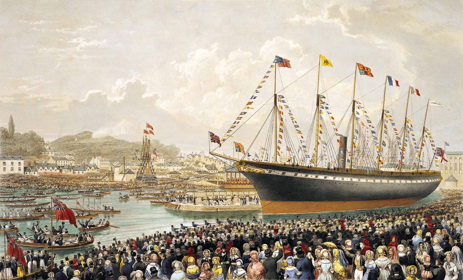
| | | | Following WWII, the Harbour Grace airstrip was left to deteriorate. In 1977, the Harbour Grace Historical Society worked to have it restored to usable condition, although it was still abandoned. In 1999, the airstrip that had been used by Post, Earhart, and others, was symbolically reinstated to official international airport status. | | | | Heart's Content It was then a quick drive across the peninsula to the Trinity Bay side to Heart's Content on its deeply indented harbor. In town, it was a short drive up the coast road to the former Cable Station. Heart's Content was first mentioned in 1612 in connection with Cuper's Cove, and was used as a seasonal base for English fishermen. It was permanently settled by at least 1677. It's a small town, with a 2011 population of only 375, only about 1/3 of its population in the cable era of the 1880's of about 1200. But its greatest claim to fame is that it and its cable station weigh heavily in the history of international communication starting in the second half of the 19C, which is the purpose of today's revisit, since my recollections of our first visit in 1984 severely needed updating. It was hugely worth the effort, since more and more stories of the events keep bubbling forth. These stories involve, obviously, the first transatlantic telegraph cable (and cable of any sort) and the leap forward in communication that it allowed, but also involve the ship that finally accomplished laying the cable, the SS Great Eastern, and its designer and builder, Brunel. A number of facts I learned onsite are more accurate than other information available online. | | | | CYRUS WEST FIELD'S FIRST ATTEMPTS In the mid-19C, the telegraph was the innovative means of rapid communication, and telegraph cables over landlines connected most locations. In Europe, underwater connections were also made between the continent and Great Britain, and from there to Ireland. In North America, connections were extensive, but did not reach Newfoundland. In 1854, Cyrus West Field, an American businessman and financier, joined in a business venture with others, including Samuel FB Morse, inventor of the Morse code, in a project to lay a 645-km (400-mi) telegraph cable connecting Saint John's with Nova Scotia, overland in Newfoundland, undersea under the Cabot Strait to Nova Scotia, where mainland lines from the US and elsewhere in Canada terminated. Thus, Newfoundland was now on the North American grid. The next year, the group formed the first of several telegraph companies, (all of which were eventually acquired by Western Union), attempting to lay and operate a transatlantic telegraph cable from Newfoundland to Ireland. | | | | In 1857, with financing and governmental backing, they began laying the first transatlantic telegraph cable, running the undersea cable along a shallow submarine plateau. In the long run, with a successfully operating cable, the communication time between North America and Europe would prove to be reduced from ten days--the time it took to deliver a message by ship--to a matter of minutes, although it didn't work out that way at the beginning. All in all, four early attempts would be made to lay cable, with temporary success on the second try, and with the first real success on the fourth. These were the predecessors to numerous cables since. | | | | The cable was manufactured jointly by two English firms. It consisted of a core of seven copper wires weighing 26 kg/km (107 pounds per nautical mile), which was then covered with three coats of gutta-percha as insulation, weighing a lot more than the copper, 64 kg/km (261 pounds per nautical mile). This was then wound with tarred hemp, and over that there was a metal sheath consisting of a close spiral 18 strands of iron wires, each strand further consisting of seven wires. The final weight of the cable was nearly 550 kg/km (1.1 tons per nautical mile). Yet the cable was relatively flexible and could withstand a pull of several tons. | | | | I had heard vaguely of gutta-percha and was aware that it used to be used as cable insulation, but when my dentist told me shortly before I left on this trip that he was putting gutta-percha in my tooth, I felt it was time for some additional research. The term gutta-percha refers to a genus of tropical trees in Southeast Asia, and also to the rigid natural latex made from its sap. Apparently "percha" is the kind of tree, and the name translates from Malay as "percha sap". Overuse of gutta-percha during the second half of the 19C, particularly for cable insulation (!!!) led to a collapse of its availability. Its latex is biologically inert, resilient, and, obviously, a good electrical insulator. It was not attacked by marine plants or animals. It was used well into the 20C, but today it has been replaced by polyethylene, the most common of plastics, which is an even better insulator. | | | | That it's biologically inert and didn't react in cables with marina flora and fauna also means that it doesn't react with the human body, and is used in dentistry during root canal therapy to fill the space inside the root of a tooth afterward. Thus when I saw the remnants of the cables in Heart's Content I felt some solidarity with them! | | | | The first two cable-laying attempts were different from the later ones. On the first two, because of the amount of cable needed, two ships had to be used, which would involve a mid-ocean splicing of cables. The British ship was the HMS Agamemnon and the American one was the USS Niagara. On the 1st attempt in 1857, the two ships started in Ireland, but the cable broke twice, once when they were already far out to sea. On the 2nd attempt in 1858, the same two ships were successful, and on 5 August 1858, the Niagara landed the first successful transatlantic telegraph cable in Trinity Bay. However, contrary to what many sources quote, but which the cable museum clarifies, that wasn't in Heart's Content. The original location was much further into Trinity Bay, at the corner of the isthmus and the next peninsula, at the inlet called Bull Arm near the present town of Sunnyside (we spotted that on the map earlier). The first communications occurred several days later, on 16 August, when Queen Victoria and President James Buchanan exchanged messages, and there were great celebrations everywhere, since it was the first such project to yield practical results. However, reception was terrible on this cable. It took two minutes to transmit just one letter or number, and the first message from Victoria took 17 hours to transmit. With such poor results, the operation of this cable was terminated after about two months, on 28 October, and the cable abandoned. | | | | This is a map of the route of the cable of 1858. Note in the lower left the drawings of a cross-section and a length of cable. Above that are telegraph routes in the US and British North America (to become Canada eight years later), including from Nova Scotia to Saint John's. On the right, note European telegraph lines reaching Great Britain, and then Ireland. The cable was laid at first from the Irish mainland near Valentia Island, but later attempts were from the west side of Valentia Island itself. The lines across the Atlantic on this map are very informative. First, to correspond to the cross-section of the sea floor at the bottom, which it says was sounded in 1856 by the US steamer Arctic, is a squiggly line showing the "track" of the Arctic. Second are other lines called "steamer tracks" a casual term which indicate that standard transatlantic ship service was still in its infancy (see Brunel below). Most interesting to me is the third point, which answers my question as to why the cable did not arrive at Saint John's but in Trinity Bay, which, by the way, is marked as its Newfoundland destination, with no reference to Heart's Content, since that only came later. Why they had it reach all the way in to Bull Arm is indicated by the continuation of the dotted line, marked "proposed". From this map we see that, even though they had already built the connection to Saint John's, they were nevertheless proposing to extend the transatlantic cable, after it arrived at Bull Arm, across the isthmus, then underwater again down Placentia Bay and directly to Nova Scotia, bypassing Saint John's entirely. Although the failed 1858 cable was the last one to go to Bull Arm, and newer ones went to Heart's Content, it was the poor state of the land line to Saint John's that caused this extension to actually materialize in 1873, starting in Heart's Content with its later cables. | | | | After more planning and financing, for the next attempt the SS Great Eastern was brought into the picture, which proved to be the pivotal turning point in the cable-laying project. it was one of the most famous of the 19C ships, but why was it famous, what made it a better choice, and why did its owners deign to allow a famous passenger ship to do commercial work of this sort? It all started with Brunel. | | | | BRUNEL The most famous British mechanical and civil engineer, certainly of the 19C and probably of all time, had the improbable name of Islambard Kingdom Brunel. His innovative designs and structures revolutionized public transport and modern engineering. He built the famous Great Western Railway (GWR), whose routes lay west of London. It was notable, at least at the start, for its broad-gauge at 7 feet, ¼ in or 2140 mm. He designed and built tunnels and bridges, most notably the 1864 Clifton Suspension Bridge (Photo by Gothick) over the River Avon near Bristol, which at the time had the longest span of any in the world. | | | | But what Britons considered one of his most astonishing proposals at the time was to extend his Great Western Railway westward beyond Bristol to New York via ships on regular routes. It was this unheard of suggestion (early rail 'n' sail, right?) that ships could cross the Atlantic westward on a regular basis and regular schedule, just as his Great Western trains regularly went from London's Paddington Station west to Bristol (their successors still do), that makes Brunel the father of scheduled transatlantic crossings. He was way ahead of his time, which is why his transatlantic efforts weren't financially successful in his day. It would be several decades before long-distance steamship travel became a viable industry, but that doesn't detract from Brunel being a revolutionary thinker. In a 2002 poll of the greatest Britons, Brunel placed second after Churchill. | | | | His transatlantic shipping accomplishments were three ships, which he considered a transatlantic extension of his GWR. The three notable steamships he designed and built revolutionized naval engineering. The names of all three started with "Great": the SS Great Western, the SS Great Britain, and the SS Great Eastern. | | | | SS GREAT WESTERN The earliest was the SS Great Western, depicted here on her maiden voyage in 1838. Even its name indicates Brunel's plan that the SS Great Western was an extension of the Great Western Railway, which, by happenstance, had to continue in a westward direction to cross the Atlantic. The Great Western was an oak-hulled, paddle-wheel steamship, and was the first steamship purpose-built for crossing the Atlantic. She was the longest ship in the world at the time, starting out at 71.6 m (235 ft), later expanded to 76.8 m (252 ft), and had steam-powered paddle wheels plus four masts for sails, as backup. She arrived in New York with a third of her coal remaining, proving Brunel's calculations had been correct and showing the viability of transatlantic steamship service. She traveled on 46 crossings to New York over eight years, until her owners went out of business, was sold to a company that used her on the West Indies run, she served as a troop ship in the Crimean War, and was scrapped in 1856 at the tender age of 18. | | | | SS GREAT BRITAIN It was five years after that first launching when, in 1843, Brunel launched, as shown in this image, the SS Great Britain (Image by Lordprice), whose name is an obvious choice. She was the first transatlantic steamship that was both made of iron and driven by screw propulsion, although she also had backup sails. At 98 m (322 ft) she was the longest passenger ship of her day, and also the largest vessel afloat. Being made of metal instead of wood, she's considered the first modern ship. She made a number of runs to New York, but was eventually sold and put on the Australia route, where she served successfully for 30 years. She was eventually converted to carrying coal, and was damaged by a fire in the Falklands and eventually scuttled and abandoned in 1937. In 1970 she was refloated and brought back to Bristol, memorably passing under the Clifton Suspension Bridge, to the dry dock where she had been built, and later restored, to prize-winning acclaim. She was "re-launched" in 2005, and therefore is, happily, unlike Brunel's other two ships, still with us, as a museum. When I was in Bristol, I drove over the Clifton Suspension Bridge over the Avon, and right afterward, drove past, and saw from a slight distance, the restored SS Great Britain (Photo by mattbuck), docked on the Avon. | | | | SS GREAT EASTERN This time fifteen years passed until Brunel launched his third and final ship, the SS Great Eastern in 1858 (Image by Lordprice). This painting is an artist's rendering at the time of launching. It was his final ship, since he died young, at age 53 in 1859, from a stroke just before the Great Eastern made her first voyage to New York. Brunel went all-out on this ship to make her the best and the biggest, at 211 m (692 ft) long. She had cutting-edge technology for her time, was luxuriously appointed, and could carry an incredible 4,000 passengers (today's QM2 carries 2620). | | | | In actuality, she wasn't intended to do transatlantic crossings, but instead voyages to India and Australia. The reason for her great size was so that she could do non-stop voyages from London to Sydney and back—she had facilities for livestock on board—around the Cape of Good Hope in South Africa. She also had the potential to circle the globe without refueling. She remained the largest ship ever built until the turn of the 20C, when the RMS Oceanic surpassed her slightly in length in 1899 and the RMS Celtic surpassed her in gross tonnage in 1901. Presumably the name Great Eastern was a play on both Brunel's Great Western Railway and his SS Great Western, since the Great Eastern was originally destined for eastbound service. | | | | While the wooden Great Western had had paddle wheels with back-up sails and the Great Britain had had screw propulsion with backup sails, for the Great Eastern, Brunel went all-out: since twin screws were still very much experimental, he decided on a single screw with paddle wheels, plus back-up sails. Look again at the above painting, and you'll see one of the paddle wheels, the stacks (funnels), and the masts. She was one of the very few ships to ever have five funnels, as shown (they looked more like small chimneys rather than huge 20C stacks), but that was reduced to four when she was converted to cable-laying. She also had six masts, which purportedly were named, front to back, from Monday to Saturday. | | | | But the entire concept of the Great Eastern was in trouble from the start, largely because she was really ahead of her time. She had been designed, as her name says, for the eastern run to Australia, but there was never sufficient traffic, and her only passenger service was in the Atlantic. Part of this is due to the irony of the Suez Canal. Construction on the canal started in 1859, the year after the Great Eastern was launched. They had built her so large because they'd planned to send her to Australia around Africa, and then realized that the shorter canal route would soon be available, making such a large ship less necessary, as smaller ships could make it faster through the canal. Even worse, her big size was against her again, since she was too big to fit in the canal. It was being excavated to a depth of 7.9 m (26 ft) and she had a draft of 8.5 m (28 ft). Then later, that became moot, since when the canal opened in 1869, the Great Eastern was no longer in passenger service at all, but was a cable-layer. | | | | Thus, the Great Eastern had two careers, followed by a period of ignominy. Her short career, as transatlantic steamer, lasted three years, from 1860 to 1863. Her size again worked against her, as she could not compete in speed and performance with other vessels, and she was regularly underbooked. This is the Great Eastern in New York in 1860. I understand her usual berth on the Hudson River was between West 11th and West 12th Streets. Click to enlarge to better see the taxi of its day, the stagecoach advertising some place called the Western Hotel. Finally, the company that ran her went out of business, and the ship was sold. | | | | Thus the Great Eastern began her second career when she was chartered as a cable-layer. This answers my question as to why the owners deigned to have a passenger ship do this type of work—they had no choice, she was losing money. She needed to be converted for this work, which consisted of removing a funnel and some boilers, as well as great parts of the passenger rooms and public rooms to make space to install three open, iron tanks to hold the coiled cable. Her second career as a cable-layer was longer than her first, running for 13 years, from 1865 to 1878. Thus she lay 4200 km (2600 nautical mi) of the first successful transatlantic telegraph cable, and in the following years, an additional 48,000 km (30,000 mi), including from Aden to Bombay, so she did make it to the Indian Ocean, but not as a passenger ship. | | | | After these two careers she did not have another, but lived a life of ignominy. She was refitted again as a liner, but failed again commercially. She then became a showboat, a floating music hall, a gymnasium, and a floating advertising billboard as she sailed up and down the Mersey River to advertise the former Lewis's Department Store in Liverpool, which owned her at the time. She lived this life of embarrassment for about a decade, when she was mercifully sold piecemeal at auction in 1888 and was broken up for scrap the following year. She died at the young age of 31. | | | | While all three of Brunel's ships had their commercial difficulties, because of its great size, it was the Great Eastern that was referred to as a white elephant, and perhaps it was, yet it was a major factor in the world of communications. | | | | | | I had to look up to see why we use the term "white elephant" to describe something that is valuable but has little practical use, and which the owner has trouble getting rid of to avoid high maintenance costs that are out of proportion to the item's worth. It seems that the kings of Siam (Thailand), when they wanted to get rid of, and punish, an obnoxious courtier, would present him which an actual, rare, white elephant, which is actually an albino. The courtier had to accept, and keep, such a high-level gift, but would then be bankrupted by its high maintenance. |
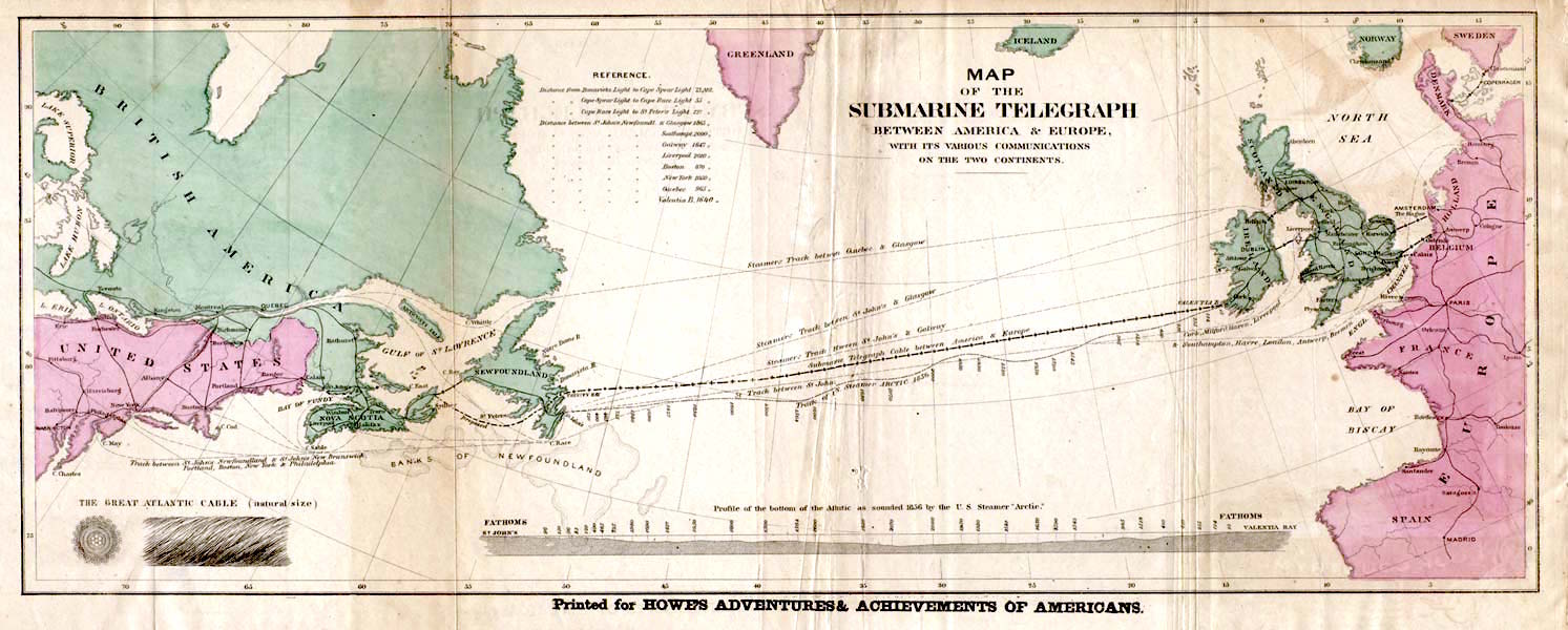
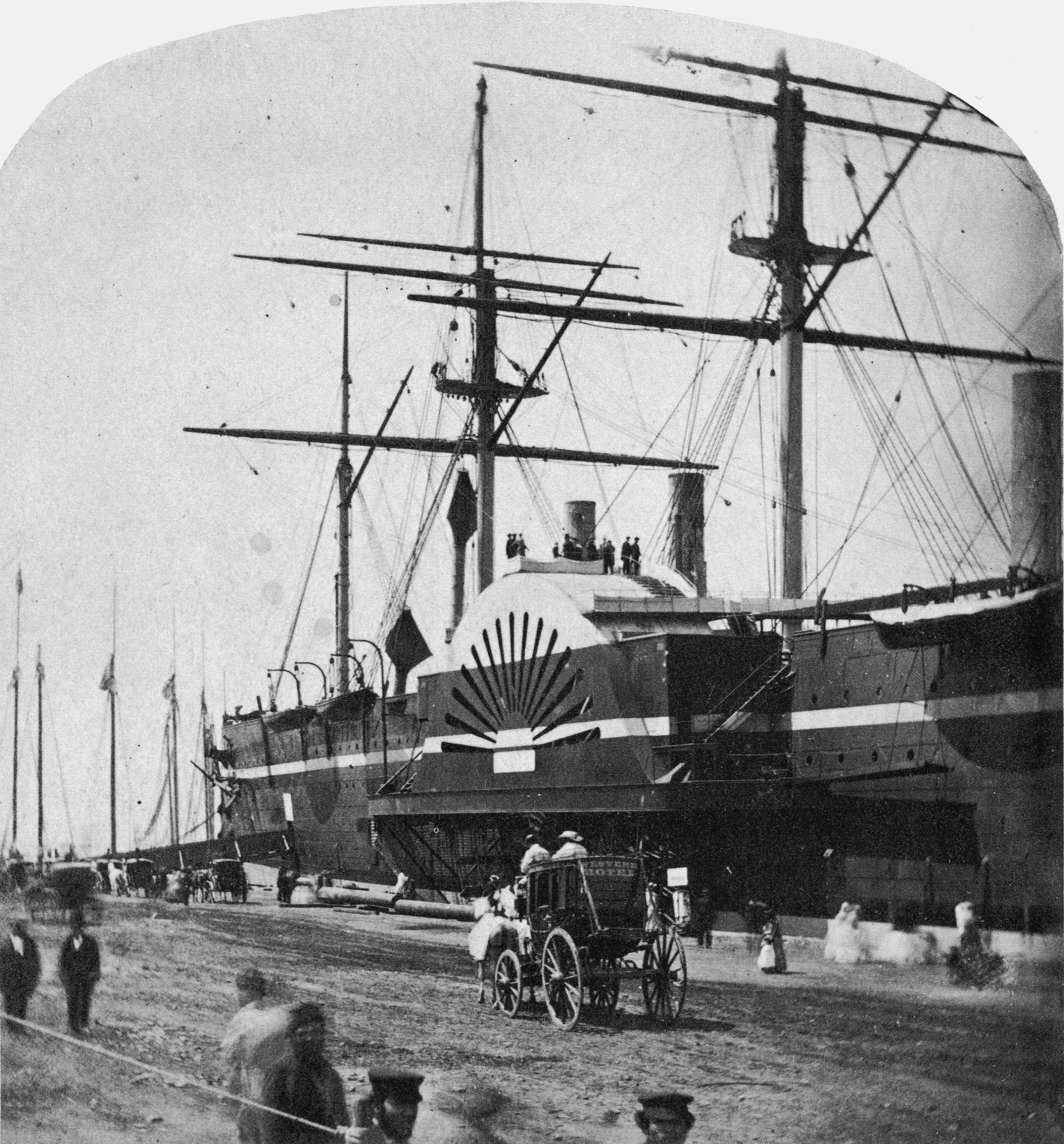
| | | | FIELDS' 3rd & 4th ATTEMPTS After the failure of the first two attempts, Fields understood that a large ship like the Great Eastern was needed that could carry the whole cable in one piece, and it was chartered and converted. It was at this point that the size of the Great Eastern came into question again. It was just too big for Bull Arm near the isthmus, so a new location had to be found. Heart's Content had that large, indented, natural harbor, and it turned out to be the only port deep enough in Trinity Bay to handle the Great Eastern. Thus, Heart's Content became the new western landfall of the cable, and it was all because of the Great Eastern. | | | | The newly converted Great Eastern—this is her deck (note the funnels and masts)—was loaded with cable in those three iron tanks and her decks were furnished with cable-laying machinery. The later cables were also laid with a lot more slack, so that they could be lifted out of the water for repair when necessary with a grappling hook. | | | | She proceeded to Valentia for the 3rd attempt in 1865. This time, the cable broke and was lost some 1111 km (690 mi) short of Newfoundland. The next year, she tried it again with an improved, more durable cable for the 4th attempt in 1866, which was finally successful. She had left Valentia on 13 July and pulled into Heart's Content Harbour two weeks later on 27 July 1866, and 50 sailors dragged the cable ashore. Again, congratulations flowed, and telegrams of salutation were exchanged between the British and US governments. | | | | Two weeks later, on 9 August, the Great Eastern went back out to grapple the previous year's lost cable. Difficult as it was to find it, it was finally successfully grappled, the lost end spliced to a new cable brought for that purpose to continue the line, and then served as a second, backup wire. | | | | For the new cables, there had been great improvement in its manufacture and in message sending. The 1866 cable could transmit eight words per minute, 80 times faster than the 1858 cable. In the first two months of this cable, 2800 messages were sent. (Eventually, by the 20C, cable transmission would reach 120 words per minute.) We're used to fast communications today, but the transatlantic telegraph cable altered so much. For instance, stock prices could be exchanged between New York and London immediately, and ship schedules became much more precise. | | | | And then there was the affect on the accuracy of longitude. Before the cable there was a difference between European and American calculation of longitudes simply before there had been no way of comparing the two. The variation between longitude measurements came to about 850 m (2800 ft), which was a particular problem with navigation. For this reason, the US Coast and Geodetic Survey sent a longitude expedition in 1866 to link longitudes in the US with those in Europe, specifically, between the Harvard College Observatory and the Royal Observatory in Greenwich. In Valentia they built a temporary longitude observatory beside the cable station about three months after the cable started operating, to calculate and synchronize longitude observations with Heart's Content. For that reason, this location on Valentia Island is called both Telegraph Field and Longitude Field. I've never been there, since I never knew about Valentia when I was driving in Ireland. | | | | To commemorate these two events, this monument (Photo by John Flanagan) was erected in 2002 in Telegraph Field. Click to enlarge to read the text. I have some comments. | | | | Two are trivialities. One reflects again on the awkwardness of the name Newfoundland, since it's referred to here as New Foundland, as though there were an Old Foundland. Also, the name of the US Coast and Geodetic Survey is compressed to the US Coast Survey, which doesn't exist. But beyond that, they've unfortunately gotten their history twisted. They're specifically referring to the 1866 cable, which is the first one that worked permanently (although they call it the 1865/6 cable, but that's OK), and then they refer to Victoria and Buchanan's messages. Those messages took place on the second cable eight years earlier, in 1858, while James Buchanan was in office, which was 1857-1861. He was not President in 1866 or even 1865. Picky, picky, but don't believe everything you read, even if it's "written in stone". | | | | The importance of the cable in popular imagination of the time is shown in that it appears at least twice in international literature. I understand that, in Jules Verne's "Twenty Thousand Leagues Under the Sea", one of the many underwater landmarks that the Nautilus observes is the cable, and that Hans Christian Andersen wrote a story called "The Great Sea Serpent", referring to the cable, which describes how the laying of the cable causes havoc and confusion among the sea creatures. | | | | We are discussing here only the four earliest, most historical attempts by Fields' company, and to recap, of the first two attempts, the second was only temporarily, and minimally, successful. Of the second two attempts by the Great Eastern, again it was the second of those that was the great success, and the one before it was then able to be salvaged, too, so there were two operational cables. But that wasn't the end of it. The 1865 cable had to be abandoned in 1877, and the 1866 one even earlier, in 1872. Thus, the Great Eastern, in addition to other cable-laying work, also laid the two subsequent ones between Heart's Content and Valentia, in 1873 and 1874, and another ship, the Scotia, laid two additional ones, in 1880, and 1894. This eighth and last one on this particular route was in use until 1965. | | | | The original Victorian brick cable station in Heart's Content was enlarged by a rather ugly, big white addition in 1918 to serve the original company and its successor, Western Union, until the closure of the station in 1965. It closed because of new forms of communication, but in addition, trawlers had cut the cable, and the cable had decayed anyway. In 1968 the cable station was bought by the provincial government as a historic site. It was restored and made into a museum in 1974, which opened on 27 July that year, 108 years to the day that the successful 1866 cable arrived. | | | | CABLES TODAY Western Union dates back to 1851 and expanded rapidly. It opened the first transcontinental telegraph in 1861, and continued expanding by acquiring other companies. In 1865 it entered into a short-lived venture to link North America to Europe in the other direction, via Alaska and Siberia to Moscow, but that was abandoned in 1867. Western Union eventually took over Field's telegraph companies and the transatlantic cables. With changing modes of communication and drastically declining demand, it discontinued telegram service in 2006 and is now largely a financial services company offering money transfers. | | | | Transatlantic telegraph cables were replaced by telecommunications cables carrying telephone traffic, then data communications traffic. Modern fiber-optic cables carry data digitally, including telephone, internet, and other data. | | | | VISITING THE CABLE STATION We left off arriving in Heart's Content at the former Heart's Content Cable Station (Photo by Robthepiper), which is directly on the right side of the main road and across from the bay, with a grassy slope leading down to the bay on the left side of the road, behind the camera in this picture. The older Victorian building is attractive and quaint, the 1918 extension not so much. Inside, there are displays about cables, about life in Heart's Content and at the station over the years, and an introductory film was particularly helpful in understanding the social situation in town. There's a full room of the last equipment that was used, and at a table, you could try your hand at sending Morse code. | | | | Beyond the technical items, it was the social situation that was most interesting. When the cable company brought in its people, and added to them over the years, there was a definite class split in town between the townies, who largely supported themselves by fishing, and the cable people, not unlike the "town 'n' gown" split in college towns. The cable people had their own neighborhood, and expensive private schools that others didn't have. Of course, there were quite a number of townies who did go to work for the cable company. Of particular interest were the women that were hired and trained, particularly during WWI when there was a shortage of men. I remember three women being cited in particular, one of which made a lengthy career out of the job. The other two, also skilled operators, worked only 2-3 years. Any idea why? | | | | It was a sign of the times. The other two women got married, and in those days, married women just did not work, so they resigned. It's a shock to see the difference in customs, particularly about women. Women were also recruited from out-of-town, which resulted in a problem. While there were many places in town for men to live, the situation for women was difficult. On that basis, the telegraph company established a boarding house just for women. But of course, again as a sign of the times, it had to be chaperoned, and I just love the word they used to describe the chaperon. Similar to other dead-or-dying "X" words like "aviatrix" and, in the field of wills, "testatrix" and "executrix", based on the word "janitor", the chaperon was called a "janitrix". Priceless. I checked in the dictionary and the word really does exist, obscure as it may be. | | | | In the room with the machinery you could go to the back wall and see where the ends of the cables, all in a cluster, left the machinery and went down into the floor, then out the building. But better still, and the thing that remains most memorable to me about visiting the cable station, is to then go just a few steps across the road, down the grassy slope onto a short wooden staircase to the beach. Standing on the staircase, you see to your left a bunch of very frayed cables springing out of the slope and arc-ing down onto the sand, across the short beach and into the waves of Heart's Content Harbour on their way to Ireland. | | | | Dildo Turning south now on the way to the Trans-Canada Highway back to Saint John's, you leave Heart's Content and promptly drive through Heart's Desire, then Heart's Delight. As I understand it, the unusual names of this trio probably came from fishing vessels they were named after. You will be able to picture this better when you think of people's pleasure boats you've seen and consider how similar these three names are to typical names you encounter there. | | | | Further down the coast is the town of Dildo (Photo by Jcmurphy), one of those places everyone has got to stop at, if for nothing more than to actually see a sign that says you're there. People had even talked about it around the dinner table up at the Tickle Inn at Cape Onion. I was more curious than to just drive by, so I turned off the toad a few kilometers into town to see Dildo Harbour (Photo by BriYYZ), with its fishing boats. If you refer to our Avalon map of record, you'll see that Dildo is on Dildo Arm of Trinity Bay, right at the isthmus, and Dildo Arm is close to a mirror-image of Bull Arm across the way, of cable fame. Despite its unusual name, the town was quite comfortable and normal. | | | | One might wonder why the name hasn't been changed. The answer can be indicated by the fact that we're talking about the town right now—notoriety. Everybody remembers the name. There were several attempts during the 20C to change the name, and all failed. | | | | We can try to figure out why the town has this name, and also where the word came from in the first place, but the two seem to be intertwined, with no definitive answer for either question. To some extent, it's what came first, the chicken or the egg? Let's start with the maritime use of the word. In rowboats, the oar rests in an oarlock (British: rowlock) which is used to guide the oar. The oarlock's U-shape holds the oar and acts as a fulcrum. The U is on a pin which is inserted into the side of the boat. In place of the oarlock there can be—or earlier, was--just that pin alone, or a vertical wooden peg, or a pair of them, in the side of the boat to perform the same service. This peg is called a thole, and was once also called a dildo. Presumably this handy little peg is what developed into the sex toy of the same name, but this is just a theory. What if the sex toy came first and then they named this similar-looking (but smaller) peg after IT? | | | | It's possible that the town of Dildo, being a fishing outport, also got its name from this maritime use. North of Saint John's are both Pouch Cove and Shoe Cove, both apparently named for objects, although not maritime ones. In addition, the word "dildo", wherever it started, spread to other uses. In the 16C, a test tube was referred to as a dildo glass because of its cylindrical shape, and at one time, "dildo" was an insult for a contemptuous man, like calling him an idiot—or a dipstick. | | | | As for the word's origin, no one really knows. The Online Etymological Dictionary is vague about it. It says it's perhaps based on the Italian word deletto "delight". They say it's less likely that it comes from "to diddle". I would say that, given the meaning of "diddle" (DI.dl), it's quite possible that the second syllable was reversed and an –O was added. While forming words in English by adding –O is not common, it's certainly possible: kiddo, wino, bucko, sicko, wacko; using "dildo" to refer similarly to a person, as an insult for a man as above, fits into this series of words. | | | | "Dildo" or "with a dildo" was also used so in Elizabethan ballads as a meaningless nonsense phrase like "fa-la-la" or "with a hey-nonny-nonny". Note this selection on YouTube by Elizabethan composer Thomas Morely, "Will You Buy a Fine Dog?". What I find particularly interesting in this song is that, at least in the read-along text, "diddle" varies with "dildo", possibly implying a relationship between the two. And then there's the old nursery rhyme starting "Hey diddle diddle, the cat and the fiddle . . . " | | | | That the word started out as referring to the sex toy would be supported by the fact that there was found in the library of Samuel Pepys, of diary fame, a song called "The Maid's Complaint for want of a Dil Doul". Another reference is similar, saying the Old Norse word dilla, "to soothe", appears in the form "dill-doll". | | | | Just how the name appeared for the town remains unclear. Dildo as a local place name was recorded in 1711 and again in 1775, in reference to nearby Dildo Island, Dildo Arm, and the town of Dildo. It was Captain James Cook and his assistant Michael Lane who mapped Newfoundland in the 1760's, and it's been suggested that they may have enjoyed showing a sense of naughty humor in a provocative choice such as this. But while putting the onus for the name on their shoulders in the 1760's could explain the 1775 reference, it wouldn't explain the 1711 reference. | | | | If it wasn't Cook, perhaps it was locals who, earlier, had named the town with the maritime word, the thole/dildo, or perhaps after some person, as the insult/dildo. I would think it unlikely that they'd give it the sex toy/dildo name, which might have developed even later. The bottom line is, just what the origin of the word is, and just how it also became the name of the town, simply remain a mystery. | | | | But one thing is clear, to me, anyway. Humor, or humour, seems to rise out of the ground when in Dildo. You just can't help it, jokes simply write themselves. Maybe it's the air. Before even driving out of town, several of the following thoughts had occurred to me. | | | | | | A sign pointed to a souvenir shop. Just what is it they sell in the Dildo Souvenir Shop?
Another sign pointed to the town recreation center. Just what activities take place in the Dildo Recreation Centre?
I didn't see the Chamber of Commerce, but they must have one. What slogans might they use to attract vacationers? Maybe "Come to Dildo and Enjoy Yourself!" or "Dildo--an Experience You'll Never Forget!" They could modify the slogan used by the State of Virginia and make it "Dildo is for Lovers".
|
| | | | I can't stop. Anyway, it's your turn. Think of a few as we drive back to Saint John's. | | | |
| |
|
|
|

