|
Reflections 2013
Series 12
July 20
Atlantic Isles IX c: Labrador's South Coast - "Oldest Settlement"
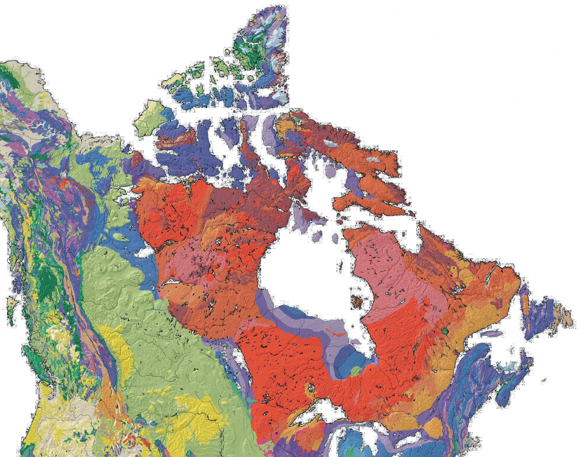
| | The Original East Coast I had decided when planning this trip that, after the Top of the Rock, which was my principal goal, since I was that far north already, I might as well visit the south coast of Labrador as well before moving on to a revisit of Saint John's and the Avalon Peninsula, my last stop. In Labrador, driving up the Labrador Coastal Drive sounded like the thing to do to see the area, and so it was. | | | | I was aware that politically, the Strait of Belle Isle formed the border between the two parts of the province of Newfoundland and Labrador. Simple enough. But only now, doing some additional post-trip research about the area, I've come across the geological history, and now I realize that in crossing the Strait, I moved from "newer" North America to "older" North America, and not by a bit, but by a difference of 100 million years. And in doing so, I find I set foot on North America's original east coast. Furthermore, I found that Labrador and adjoining areas are not only those many years older than Newfoundland, they aren't even geologically related. Labrador is geologically "old family money" while Newfoundland is an immigrant "nouveau-riche" upstart. I was quite amazed by the story I discovered. | | | | This is a geological map of North America, (Map by Qyd—click to enlarge), but which is missing Greenland. Labrador is the easternmost part of the Canadian Shield, the area in the deep earth-colored shades of red, purple, and brown on the map. If Greenland were properly included on the upper right, since all of Greenland is part of the Shield, you would see that the Shield is roughly circular around Hudson Bay, like a donut around a donut hole. The Canadian Shield is a huge rocky area that forms the ancient geological core of North America, covered by a thin layer of soil. From the map you can see that roughly, the Shield covers the eastern half of Canada and extends somewhat into the Upper Midwest of the US, west and south of Lake Superior. | | | | On the other hand, Newfoundland represents the northeasternmost extension of the Appalachian mountain system in North America, which starts in Alabama and ends, as we mentioned, with the mountain on Belle Isle, its northeasternmost peak. This system is in cool tones of blue on the geological map, and covers much of Newfoundland, including the "Top of the Rock", with the interesting exception of the mountains running the length of the Great Northern Peninsula, which, surprisingly, are part of the Shield. It is because of the difference in age between the Shield and the Appalachians, that the island of Newfoundland is so much younger than Labrador. In the same way, the rest of Atlantic Canada, New England, and areas southwest are much younger than Québec, Ontario, and areas west. Study this interesting map and compare the older, established area to the newer, upstart area. | | | | An essential part of this story is the remarkable wanderings of the island of Newfoundland. 500 million years ago, a pre-Atlantic ocean floor separated North America and Europe/Africa. Then continental drift caused North America to sidle up to Europe/Africa and lie next to them. Following that, that ever-fickle continental drift at a later period, 400 million years ago, started pulling North America away again and the Atlantic Ocean was formed separating the continents. However, the new Atlantic split occurred further east than where the old one had been. How much further east? About the width of Newfoundland, with the result that Newfoundland was stuck on to North America as it traveled westward again. So were the remaining Maritimes, New England, and south, those areas in blue. | | | | The amazing result about Newfoundland in particular is that it has a three-way split personality, geologically speaking. Those western mountains, in brown on the map, are, and always were, part of "old" North America (the Canadian Shield), originally being North America's EASTERN edge. However, that piece of the original coast ended up on the wrong side of the Strait of Belle Isle, that is, as part of Newfoundland. All of central Newfoundland, blue on the map and part of the Appalachians, had been part of the ORIGINAL, pre-Atlantic, ocean floor that was dragged westward. And eastern Newfoundland, the Avalon peninsula, plus a bit more, shown in gray on the map, is—are you ready for this?—a piece of either southwestern Europe or northwestern Africa, both on the eastern plate, that stayed stuck to the rest of Newfoundland inasmuch as it now was stuck to the western plate, during the formation of the new ocean, the Atlantic. Thus, as those western mountains ended up on the wrong side of the Strait of Belle Isle, the Avalon Peninsula ended up on the wrong side of the Atlantic. | | | | In sum, Labrador and Québec, and beyond, including all the north shore of the Saint Lawrence, are geologically an "older North America" and Newfoundland, Québec's Gaspé Peninsula, the other Atlantic Provinces, New England, and beyond, are the "newer North America". This now leads us to understand why the estuary of the Saint Lawrence, as well as the Gulf of Saint Lawrence, even the Strait of Belle Isle, are so wide. They're part of the separation between the two parts of North America that never finished closing up. Furthermore, the north shore of the Saint Lawrence is the ORIGINAL east coast of North America. This would explain why the river gets wide north of the city of Québec. The Saint Lawrence coming downstream has always formed its own bed, but then after passing Québec, it enters the wide area of the estuary that never closed up. | | | | Look at the map again and find Lac Saint-Jean and the Saguenay River (2013/1) as they empty into the Saint Lawrence. It always made me wonder, right through writing about this fjord and its graben earlier this year, that a fjord, which one always pictures as a coastal phenomenon, should be so far inland, emptying into a river. Now we can see that, as the continents were moving, this was a shoreline, a place where one could expect a fjord. | | | | Now part of this former coastline is inland, in Ontario and in Québec Province upstream from the city of Québec. While this part, too, was the coastline, it's no longer on the water. What I wanted to see was, just where had I trod this coastline where it still borders water? When visiting the Saint Lawrence, so much more activity takes place on the south bank that there are fewer places to visit on the north bank. I've driven the length of the south bank, all around the Gaspé Peninsula in 1980 and 1983, and that's also where the train runs. But the north shore? That's much more isolated. For me, it would have been in and around the Saguenay Fjord, particularly Tadoussac, this last autumn. Also on that 1983 trip, we drove from Tadoussac down to Québec. All that would be the western end of the old coastline. But otherwise, that's the only time I visited the original east coast of North America until I ended up unwittingly visiting its eastern end, MUCH further east, this June in Labrador. | | | | Labrador's South Coast Getting from either Onion Cove, L'Anse aux Meadows, or Saint Anthony itself (2013/11) to Labrador presents two choices, the ferry and the plane. Both will bring you to Blanc Sablon, Québec, the easternmost town in Québec province, but only minutes from the border with Labrador. I described in 2013/10 how, in any case, the time in Blanc Sablon at this time of year is 1.5 hours earlier than the time in both Newfoundland and Labrador, so one has to be very careful about the time difference when schedules are quoted so as not to miss connections. | | | | My inclination would have been to take the ferry, but I chose the plane, using this rationale. I retain a dread of long road drives in Northern Newfoundland based on not being able to make it all the way north the first time we'd considered it. This time, I could have driven past Saint Anthony Airport down to the ferry terminal in Saint Barbe, taken the 3:30 PM ferry for the 90-minute crossing and it would have worked well. However, on the return, even taking the only alternate, the 10:30 AM ferry, would have gotten me back by noon, but that would have been followed by a substantial drive to the airport, where my flight down to Saint John's left at about 1:00. That would have been impossible, given that long country drive again. With this scenario, I'd have to have stayed over one more night somewhere on the Newfoundland side just to have had time to make connections, and that didn't appeal to me. I kind of missed not taking the ferry, but flying was the wiser decision, since pricewise, the fee would be reduced as being an extension of my Saint John's ticket. | | | | So from Cape Onion I drove to Saint Anthony Airport in the middle of nowhere, returned the car, and took the flight. What was scheduled as a 25-minute flight included "fat", because it only took 15 minutes. The best map I could find to show the area is the Parks Canada map for the Red Bay Historic Site, as was also the case with the Norse Historic Site. This map, as that earlier one, is copyrighted, so I'll ask the reader to open a separate window and copy-and-paste this page to refer to the map at the Parks Canada website: http://www.pc.gc.ca/eng/lhn-nhs/nl/redbay/visit/comment-how.aspx | | | | The fact that the Strait of Belle Isle is at an angle of approximately 45° causes disorientation. One knows Labrador is north of Newfoundland, yet for this connection, I traveled west. That's because the Top of the Rock area on the Newfoundland side is at the eastern end of the strait, while most of what wants to see on the Labrador Shore is at its west end. On the map, Red Bay is roughly west of Onion Cove, and Blanc-Sablon is roughly west of the Saint Anthony Airport. | | | | Labrador Coastal Drive The Labrador Coastal Drive, here along Labrador's south coast, is part of the Trans-Labrador Highway. We described in 2013/10 that the final connection in Labrador has now been completed, so that one can come up the Saint Lawrence past the Saguenay fjord and Tadoussac up to Baie-Comeau, then proceed inland in a large arc from Québec into Labrador to Labrador City and Goose Bay and then to the east coast of Labrador and swing around to the south coast, coming in "backwards", that is, from the east. Much of this route is gravel, but at Red Bay it's paved, and continues so back into Québec at Blanc-Sablon. It does go west beyond that, still paved, for some 70 km (43 mi) to a tiny place called Old Fort Bay, but then ends. There are hopes someday to continue this road to complete the loop back to Baie-Comeau. Thus the only paved highway in the area is about an hour-and-a-quarter's drive in either direction from the Labrador-Québec border, but it's the Labrador side that's of particular interest, the Labrador Coastal Drive up to Red Bay. | | | | The entire strait has a history of French names, as shown already by L'Anse aux Meadows. But given the fact that Québec and Labrador abut here, both languages are common. With Blanc-Sablon being in Québec, I expected a French-speaking majority, which of course, the signage would indicate, given Québec's language rules, but it turns out that in Blanc-Sablon there are three speakers of English as a first language to one of French. While most towns on this Labrador-Québec stretch of road have populations in the low hundreds, Blanc-Sablon is apparently the big town with about 1100 people, which is probably why it has the airport. The name means "White Sand", which is probably better translated as "White Sands". | | | | One of the villages that make up the town, Brador, has a name with a curious history. As sometimes happens, the name involves a mistake. This whole Labrador area is traditionally referred to as the Labrador Coast, or Côte de Labrador (old spelling: coste). But in documents from the 17C and 18C, there was an error made in the French name, where one word was understood as two, so the area was written as coste de la Brador. From this misinterpretation, the village of Brador got its name. Further curious is that, when the border was drawn, Brador didn't end up in Labrador, but in Québec. | | | | When I picked up my car at the Blanc-Sablon Airport on the west side of town and told the guy I was going to nearby Labrador, he took me outside and pointed to a rise of land to the east, which had a huge communication tower on top of it that I could see from here, across town. He said "That's Labrador", and so it was. But when I reached the east side of town, I drove off a bit down to the water to the ferry dock. As it turns out, the morning ferry from Newfoundland was in, so at least I got to see it. | | | | While Northern Labrador's climate is classified as polar, or arctic, Southern Labrador's is subarctic, like Newfoundland, and the area was as green and as lush as I'd been seeing. I also found it of interest that, until the 1950's it was mostly aboriginal people that lived in Labrador, and few others year-round. It wasn't until the development of natural resources there in the 1940's and 1950's that the non-aboriginal population began to permanently settle in Labrador. | | | | I drove the short distance from town to the border, where signs welcomed me to Labrador, and I was glad to be back in the province of NL, where my watch was telling the right time again. Right across the border was a town with another name in French, and one of many using anse, L'Anse-au-Clair. Clair as a noun means "light", as in Clair de lune, so the town's name means "Cove of Light". Further up the road to Red Bay is L'Anse-au-Loup, or "Wolf Cove". | | | | If you check out the map again, you'll see that no more than 15 minutes out of Blanc-Sablon, there's a deep bay in the coast and the road makes a large arc around it. This is Forteau Bay, with "my" town of Forteau (not named on this map) wrapping around its western and northern end (my B&B for two nights was on the west side), and on the far side of Forteau Bay is L'Anse Amour where I would spend my afternoon. My second and final day I would take the hour's drive, via the Pinware River, to Red Bay, on the far side of its namesake bay. | | | | Forteau As I entered Forteau, population 429 (2011), I followed the sign and turned off down the west side of the bay to the Grenfell Louie A. Hall Bed and Breakfast. We mentioned Sir Wilfred Grenfell, the medical missionary whose museum and former house are in Saint Anthony. This building, named after him originally as the Forteau Grenfell Nursing Station, was one of the many nursing stations he and his organization built around NL. It was built in 1946, and was in use to the 1980's when a medical facility was built elsewhere to replace it. Peggy Hancock and Dwight Howell bought the building and converted into their home and a B&B. Another quirk is that they were both born in the building when it was a nursing station, as were many locals of their generation. Apparently Louie A. Hall financed construction, which accounts for that name. Only on arrival did I see a picture of Louie A. Hall, who turned out, surprisingly, to be a woman. I said to Peggy when she got home that evening that I suppose that "Louie" might have been short for Louise, but it seemed like news to her and she wasn't sure. Otherwise, she filled me in on the building's history and local life. | | | | This is the former nursing station, and present B&B, as it looks today. Its white color and green trim was a refreshing variation from other houses locally. The breakfast room is in the two closest windows on the corner. I particularly asked that my room face Forteau Bay, so it's one of two under the peak in the back. This is the breakfast room, and this is the lounge, also on the main floor. The main floor had been the medical facility, while upstairs was the nursery, in front, and nurse's rooms in the back, with the water view. All three of these pictures are taken from the website of BBCanada.com, which I've found very helpful in many B&B choices. If you're interested, you can look further at this B&B on the BBCanada website. I particularly suggest you check out "Bedrooms" (I was in the Mary Taylor Room) and "Photo Gallery", where there may be a couple of pleasant surprises (icebergs, beaches, partridgeberries). | | | | When I arrived early in the afternoon, no one was home, since both Peggy and Dwight worked elsewhere, and no other guests had arrived yet. What an unusual feeling! The front door was unlocked, a sign urged me to fill out a registration card, another note on the door welcomed me and an arriving couple and told us how to get to our rooms. We were also asked not to wear shoes inside the house, which is fine with me (I'm even barefoot at home), but I do like to carry my shoes up to my room. I had the run of the house, but got settled in. There were two "shared" baths right out my door, so there was never a traffic problem. I'm delighted to say that, over some nearby low roofs, my view of Forteau Bay was good, including a mid-sized iceberg that stayed in the center of the bay my entire visit, and a view of L'Anse Amour Lighthouse in the far distance on the right, across the bay. What a pleasure. | | | | I had a half-day I'd scheduled to see the local area and started by driving, not toward, but away from town to the point of land where the road ended on the west side of the bay, where a sign explained local history, including the name Forteau as meaning "strong water". Frankly, while the name looked French, it also looked like a Frenchman's name. In addition, "strong water" would normally be eau forte. Still, I suppose in an exaggerated sense the word order can be reversed, so I was particularly happy when it wasn't some guy's name but a geographic reference to the bay I was enjoying. The name remains in French, but it corresponds to an English name like Strongwater. Nice. | | | | I then drove into town, which was pleasant enough, but much like any town with a major road serving as its main street. I searched out the Seaview Restaurant I'd discovered months earlier online, and also found a gas station, for filling up on departure, because there can be quite a distance between them in remote areas like this. I reached the east side of the bay, and turned of on a side road, a dirt road, leading to L'Anse Amour and its two sights. | | | | L'Anse Amour I may have seen the town itself, I don't know, because online its population is listed as 8. Maybe it was some of houses I drove by on my way out to the lighthouse. But the name of this town is as much fun as any on the strait, and its quirk is purely within French. | | | | You have to get suspicious early on. L'Anse Amour. Why would anyone name a place Love Cove? Hanky-panky on the beaches? Hardly, in this weather. Then wait a minute. Even if you don't know much about French, isn't there a grammatical connection missing? Wouldn't Love Cove be L'Anse à l'Amour? What's wrong here? | | | | The answer is priceless. Maybe because of shipwrecks that have occurred here—they did have to build a lighthouse, after all—the town was originally named L'Anse aux Morts, the Cove of the Dead. Don't look at the spelling, which is grossly misleading. Look at what comes after L'Anse and you'll see that o.MOR changed to a.MUR. The two consonants remained the same, but both vowels changed, and Cove of the Dead became Love Cove. You couldn't make these things up if you tried. | | | | Maritime Archaic Burial Site To understand the significance of the first site, I had to learn about an ancient people called today the Maritime Archaic, Archaic because of the age of the long-disappeared culture, and Maritime because their location covers the coasts of the Canadian Maritime Provinces, including Newfoundland and Labrador, and northern New England. They existed from between 9000 and 3500 years ago, and one of their largest and longest-used habitation sites in Labrador surrounds L'Anse Amour and represents the remains of many small camps. Still, that alone is not the main point of interest here. That is a burial mound that features the earliest known funeral monument in the New World, which is 7500 years old. Put it this way. The Norse historic site in Newfoundland is 1000 years old, but this aboriginal site, of peoples whose ancestors had come here the other way, via Asia, is 7.5 times older. Heady stuff. | | | | I knew I'd be passing the burial site on this dirt road, and had seen pictures online, but the turnoff off the main highway mentioned only L'Anse Amour in general terms, and emphasized the lighthouse, something that I suppose is more visible, and more of general interest. The area next to the road was beachy, with low flora as we'd see in the pictures of the Norse historic site. I stopped once or twice along the road to look at growlers and other small chunks of ice floating among rocks on the sandy beach. It's not something you see every day. | | | | Moving along the dirt road, I passed a wooden platform on the right that had not been particularly clearly marked. As happens otherwise only in the movies, I hit the brakes, kicking up a cloud of dust, and backed up. Sure enough, smaller signs right on the platform indicated that this was the burial site. I suppose somehow I'd expected some sort of a shelter, but instead got this wooden platform, and behind it a ditch that ran along the roadside. Beyond the ditch was the Maritime Archaic Burial Site (Photo by Wiegee). Do not dismiss this as a "pile of rocks", since knowing its history and age makes it quite impressive. The low, circular mound of large stones is about 8-10 meters/yards in diameter, and is situated behind what was the main habitation area. Notice the low, subarctic shrubbery. Within the mound is a small stone burial chamber, underneath which was the well-preserved skeleton of a boy. He was wrapped in red ochre and in either skins or birch bark, and was lying face down, with his head pointing west. The pit is about 1.5 meters/yards deep. Fires, probably ceremonial, had been lit on either side of the body and there were several stone and bone artefacts buried with him, which may have been offerings. On the wooden platform was this tablet (Photo by Emdx). | | | | Point Amour Lighthouse Out from L'Anse Amour is Point Amour (Love Point!!!), which is where the 1857 Point Amour Lighthouse is located. At 33 m (109 ft) it's the tallest lighthouse in Atlantic Canada and second tallest in all of Canada. It's built of limestone and is white, with a black band about 2/3 of the way up. The former residence is now a museum, but I enjoyed the tower and grounds from the outside, with views of the strait. This link connects to the website of the Point Amour Lighthouse. Click on the picture in the text to enlarge it. | | | | Back in Forteau, although it was still early, I stopped in the Seaview Restaurant for dinner. Dessert was partridgeberry pudding and sauce. The next day, after Red Bay, I walked over from the B&B to the Seaview—it wasn't so very far—and dessert that day was a bakeapple sundae. Apparently I couldn't go wrong! On both nights, when writing in my room, once it was dark, despite occasional fog on the bay, I could see both my iceberg in the center of the bay and the blinking Point Amour Lighthouse on its far side. | | | | Red Bay On my second day, which was bright and sunny, though brisk, I drove the Labrador Coastal Drive to Red Bay, and the Basque Whaling Station Historic Site, about an hour's drive from Forteau. The route crossed an attractive wooded area, and when I reached the Pinware River, with its Provincial Park, I was surprised how attractive it was. I stopped on the highway bridge across the river—there was precious little traffic—and looked at wooded cascades upstream and the stream continuing downstream to the strait. Red Bay was just beyond. | | | | For an excellent map of Red Bay, I'll again ask the reader to open another window and copy-and-paste the following link to access another website, then scroll down a bit, and click on the map: http://nlarchaeology.wordpress.com/2011/09/23/who-else-was-on-saddle-island/ | | | | As the map shows, the road swings around the north end of the bay itself, with pulloffs providing attractive views across the bay. I had wanted to see where the gravel road took off, and I didn't have to go beyond town to do it, either, as I had suspected. At one-o'clock on the map, just as the paved road turns right down the east side of the bay, the other fork, totally gravel, takes off to the left, with destinations many kilometers away. There was also an open gate across the gravel road that could be closed when necessary. This ending of the paved road plus the gravel road into the wilderness once again gave me an End of the World feeling. However, when I spoke to one agent at the Visitor Centre, she told me that she lives in Forteau and the drive I just took was her daily commute to work. I suppose it's all a matter of perspective. | | | | Proceeding down the east side of the bay, more of the town started to appear, but only after passing tiny Penney Island (unnamed on this map), at the narrows to the bay, did the most of the small town appear. Thus I discovered the unusual quirk of the town of Red Bay, that it isn't exactly ON Red Bay, but on one of its approaches, the stretch that faces Saddle Island. Thus, the nexus of both contemporary activity in the fishing village of Red Bay, as well as the location of the historic site, is that small strait southeast of Penney Island, plus adjacent Saddle Island and the adjacent strip of town (Photo by Wiegee) on the mainland. | | | | Red Bay is tiny. It's population in 2011 was 194, less than half the size of Forteau at 429. (Maybe that's why that agent preferred to commute to work from the "big city".) The name was given by the French in the 17C as Baie Rouge, but today, the English name is used. There is also a major difference between the Red Bay and the L'Anse aux Meadows historic sites. As you can see, the Basque Whaling Station had been EXACTLY at the location where the contemporary town happened to be built centuries later, since it was a natural harbor, sheltered by Saddle Island. Still, the modern inhabitants—or anyone else—knew nothing about the Basques having been here. Just as the Norse historic site was discovered in 1960, the Basque Whaling Station Historic Site was discovered only in 1977. | | | | Basque Whaling Station Historic Site What was discovered here in Red Bay? When did it exist? Who discovered it? We're about to find that, while the Maritime Archaic Burial Site dates to 7.5 millennia ago and the Norse were in Vinland one millennium ago, the Basques came to the Strait of Belle Isle a mere half a millennium ago, in the early 1500's. And we know that because of Selma Markham. | | | | Selma Markham Canadian Historian Selma Markham was born Selma Huxley, and is related to the author Elspeth Huxley, the author Aldous Huxley ("Brave New World"), scientist Sir Julian Huxley, the first director of UNESCO, and other illustrious family members. She was born in Chichester, England, and lives there now at age 86. She met and married her husband in Canada and they lived in Ottawa, but he died very young, of leukemia. As a student, he had been interested in architecture in Andalusia, but on a motorcycle trip there, he was distracted by the Basque Country, on the Bay of Biscay, lying in both France and Spain, and became interested in Basque architecture instead. They had planned on moving to the Basque Country later in life, but after his early death, she learned Spanish, and eventually moved to the Basque Country herself in 1972, which is where the main part of the story starts. Since she had heard stories earlier in the Basque Country of Basques sailing to Canada, she started researching old documents in various places, and found huge repository of 16C documents in the town of Oñate. As it turns out, no ship ever sailed from the area without a precise, itemized inventory of its contents for insurance purposes, which she examined carefully. She also found poignant the copies of wills that sailors had written, should they never return. Finally, after five years, in 1977, based on information gleaned from those documents, she went to Red Bay to investigate the area and—well, the rest is history (pun intended). | | | | That morning, I'd heard on the wake-up radio some talk about UNESCO making a decision, but didn't pay much attention. Once I got to Red Bay, passing the Selma Markham Town Hall, by the way, the agents at the Visitor Centre were ecstatic. That morning, UNESCO had been meeting in Cambodia to decide on 16 candidates for World Heritage Sites. Red Bay was 11th on the list, and while consideration of other sites may have gone slowly, Red Bay passed with ease. The agents even quoted to me that the approval happened at 9:27 Red Bay time. By the time I left that day, and was asked to sign the Visitor Book, a bold line had been written across the middle of the page with a yellow marker after the names of yesterday's visitors, and mine was the second new signature in the book of those who have visited the Red Bay Basque Whaling Station in its new status of UNESCO World Heritage Site. | | | | Julian Huxley led UNESCO and Selma (Huxley) Markham established the site that became on of its World Heritage Sites. I suppose what goes around, comes around. In 1981 Selma Markham was presented with the Order of Canada, and just a few weeks ago, the Basque city of San Sebastián presented her with a gold medal for re-establishing the Basque-Canadian historic connection. I just read that the first weekend in August this year, Red Bay is celebrating its First Annual Basque Festival, so the buzz is growing. We'll talk about the sunken ship in Red Bay, the San Juan, in a moment, but for now we can say that a full-scale replica of the San Juan is being built in Spain as we speak, which is to sail to Canada in 2017 for Canada's Sesquicentennial, its 150th Birthday. | | | | I've told the story in detail just to show how casual, accidental, and by chance the discovery was of what Red Bay had been. She went to the Basque Country because they planned to retire there. They planned to retire there because of his interest in Basque architecture. His interest in the Basques ignited her historian's interest. And the only reason he got interested in Basque architecture in northern Spain, instead of Andalusian architecture in southern Spain, is because his motorcycle trip as a youth from the UK to southern Spain had been interrupted there . . . | | | | The Basque Whaling Station So just what is the story of the Basques in Red Bay? What made the Basques the first Europeans to come to the Strait since the Norse? It all started with cod—later it was the whales--which was always found in abundance from Newfoundland down to Cape Cod, which, quite amazingly, is actually named after the fish. It's also disheartening how overfished the cod has been, causing the economic decline of those areas. | | | | Before visiting Red Bay, I was unaware that the Basques were the first whalers, and in essence, "invented" whaling. From the 12C to the 15C Basque hunters whaled in the Bay of Biscay adjacent to the Basque Country of Spain and France. But by the 16C the whale population had declined there. Meanwhile, the Grand Banks of Newfoundland attracted European fishermen, and the Basques went there in the 1520's to fish for cod. However, their attention soon shifted to the bowhead whales and right whales that migrated through the Strait of Belle Isle and in the Red Bay area. As early as 1530, 50 Basque ships a year came from Spain and France to Red Bay, each with 50-75 men, to spend the season hunting whales and processing the whale oil on site. As was typical in Newfoundland and Labrador in those years, they did not establish any settlement, they just set up a processing factory, and then closed it down for the winter when they went home. | | | | Red Bay thus became the major center for seasonal coastal hunting and processing, and in the 16C, the south coast of Labrador became world's largest producer of whale oil, which was then shipped back to Europe for lighting. People worked day and night to process the oil, including rendering the whale fat in rows of pots over fires and under a sheltering roof. There were cooperages to make barrels for the whale oil, which were then filled and brought on small boats to waiting ships for storage until they had a full load to return to Europe. Whale ships were the oil tankers of the era, and it was the world's first industrial-scale whale oil operation. | | | | This is a view of Red Bay (Photo by NorthernLight) from an unusual angle. Don't become disoriented from what you saw on the map, since this is a view to the southeast, with tiny Penney Island in the foreground (note the icebergs in the strait). Unfortunately, Saddle Island is off the picture to the right (south), but at least we see the main harbor and the town. One drives into town from the left (north) and comes to the first of two Visitor Centres, seen with a DEEP red roof and large windows overlooking the harbor from above. This is where, among a number of exhibits of artefacts that were discovered, I saw the introductory film from which I first heard of Selma Markham and first learned about how the Basques were the first whalers. Then one continues driving to the right, down to the water's edge, just past the long red building to the lower Visitor Centre, which has a wharf. This building was just as informative. | | | | It was at this point that a sign explained that the free water taxi to Saddle Island, where one can walk around to see specific sites, didn't start service as early in the season as June, although the Visitor Centres I had just seen were open. While I did fill out a card praising Parks Canada for its Visitor Centres here and at L'Anse aux Meadows, I remained diplomatic enough not to mention that, since I was charged admission, I should still have had access to Saddle Island, even if the shuttle boat were to have run less frequently than in mid-summer. | | | | Thus I shall have to describe, without actually having seen them, that there are some remnants of the whale oil rendering pots, completed models of which I'd seen in the Visitor Centre, and also remnants of cooperages. I understand there's also a cemetery that holds the remains of 140 whalers, many of which are thought to have died from drowning and exposure to the elements. | | | | I do have a rather surprising picture taken from Saddle Island (Photo by Zorion) back across to town. The surprise in this picture, equally visible from town of course, is the rusted wreck of the Bernier, which grounded in 1966 and was abandoned. Since the SS Ethie, wrecked in 1919, still lies offshore in Gros Morne NP, I suppose the Bernier might also have a long life ahead of it, although it IS odd that it's in what is now a UNESCO World Heritage Site. | | | | The life of the Basque Whaling Station at Red Bay was not long. It lasted about 70 years, from 1530 to 1600. Historians believe overhunting led to a decline in the number of whales eventually led to the abandonment of the whaling stations at Red Bay. However, the film shown at the site gave a fascinating alternative possibility, or additional possibility for the abandonment. Basque whaling ships were commandeered and used in 1588 as part of the Spanish Armada against Britain. The Armada was decimated and many of the Basque ships were lost, preventing a new startup of any size, and after 1600, the south coast of Labrador was abandoned, and largely forgotten, until Selma Markham came on the scene. Afterward, the British and Dutch learned the Basque whaling techniques and became the whalers of record. | | | | The San Juan In 1978, a year after the Red Bay site was discovered, divers in the harbor area between the town and Saddle Island, but closer to the island, and actually near the Bernier, found the remnants of a wrecked Basque galleon. Although its name was never found, circumstantial evidence suggests it's the wreck of the San Juan, a whaler that went down in a storm in 1565. When it went down, it was carrying 800-1000 barrels of oil in its hold. Underwater archaeologists carefully removed each piece of wood, measured and catalogued it—and then returned it to where it had been. There wasn't enough of a ship to attempt a restoration, and the best way to preserve the finds was to let the sea continue to preserve the wood as it had been doing for half a millennium. However, each piece was wrapped, and buried under a layer of sand. This type of preservation not only makes sense, it's a requirement of UNESCO for consideration of becoming a World Heritage Site. The San Juan is thus the best-preserved 16C shipwreck north of the Caribbean, but the original remains under water. | | | | A sharp-eyed diver had noticed that some sailor had carved into a larger piece of wood his rendition of what the ship looked like. From this sketch, and from the measurements taken, a beautiful, rather large scale model of the San Juan has been constructed, with one side complete and the other open to show the interior, and is located in the lower Visitor Centre. Also there was something I found fascinating, a two story partial cutaway of two decks, each one with a few barrels stored on it, to demonstrate how the hold was filled. | | | | Later research tells me that other galleons have been found here for a present total of four ships found at Red Bay, plus four small boats called chalupas (below), making Red Bay one of the best underwater archaeological sites in the Americas. | | | | The Chalupa When one goes to Red Bay, one of the most impressive things to see is at the upper Visitor Centre, a restored chalupa. A chalupa is a small boat that was used at Red Bay, and which is also used in Mexico. It reminds one of a large rowboat, and chalupas are indeed normally rowed, or poled. Anyone who has visited Mexico City and the floating gardens of Xochimilco to its south, has ridden in a chalupa, usually pushed by a pole, like a gondola. Also, anyone who has eaten a taco-like chalupa at a Mexican restaurant will recognize the name, since a chalupa is often served in a U-shaped taco similar to the boat, hence the name. | | | | But at Red Bay, chalupas were used in the capture of whales. They were eight meters/yards long, and would have been manned by a steersman, five oarsmen, and a harpooner. Of the four discovered at Red Bay, one was directly underneath the San Juan, and this was the one that was given extensive conservation treatment and is on display. It's almost complete, and has only some parts of planks missing, which is marvelous, given that it's over four centuries old. | | | | There's an excellent promotional video on YouTube that shows the four items I found most interesting in the Red Bay Visitor Centres: | | | | | | 0:07 The restored chalupa in the upper Visitor Centre; note missing planks, whale mural, panoramic windows down to site
0:21 Lower Visitor Centre on water
0:23 View from Upper Centre of Saddle Island, right, and Bernier wreck, left
0:28 The chalupa again
0:41 Model of cookpots, on firepits, extracting whale oil
0:50 Cross-section of a ship showing stowed barrels of whale oil on two decks
1:21 Model of San Juan, first cutaway side, then finished side
2:16 Bernier from Saddle Island
|
| | | | The next day at about noon, I was very pleased right after the plane left Blanc-Sablon, when I looked down and could see Forteau Bay below, as clear as could be, and Point Amour Lighthouse across from it. Just 15 minutes later, we landed at Saint Anthony again, and then flew on to Saint John's. | | | | The visit to Avalon and to Saint John's will appear in later postings, but both Saint John's and a couple of stops in Avalon vie in age for the earliest European settlement areas both locally and on a larger palette. Therefore, it's appropriate that we first discuss what parameters define the term "oldest settlement" (European, not native), not just in Newfoundland—Avalon in particular--but in North America. We will see that there's more than one "oldest settlement", each one affected by the phrasing of the claim. | | | | "Oldest Settlement" Europe expanded in four tiered directions. On the north tier, Russia expanded east across Siberia to Alaska, with pretensions to California, and Scandinavia expanded west, with pretensions as far as Vinland. Both of these two northern expansions retain only historical affects on the Americas, so we can put them aside for this discussion.
| | | | South of Scandinavia on the Atlantic coast, there were four major nations. Britain and France expanded west along a central tier, and Spain and Portugal expanded west on the southernmost tier. The results of these two expansions are still felt. Rather than considering these as four different, unrelated expansions, consider that the northern area, that is, North America (more precisely, the part I like to call CanUS) ended up being affected by the Anglo-French combined expansion, and the combined Spanish-Portuguese expansion that moved to the south, that is, Latin America. (This latter term is inaccurate, since there are other Latins, most obviously the French, and the French fit logically in the first group, but "Latin America" is another one of those awkward historical terms we're stuck with.) | | | | While Spain and Portugal divided Latin America area between them, it makes sense to refer to the northern expansion as Anglo-French because those two histories are blended, in that New France was swallowed up by Britain to form Canada on the Saint Lawrence. And don't think the US didn't benefit from the French factor of this Anglo-French history; remember that a huge part of the US Midwest was once part of the (historic) Province of Québec, which reached down to the confluence of the Mississippi and Ohio rivers, including ALL of the Great Lakes. And then there's the Louisiana Purchase. | | | | The only point of interest for the present discussion is just where the border fell between the Anglo-French territory and the Latin American territory. Today the line runs across from Mexico to Cuba, but historically, the line ran across from California to Florida. Thus we're left with a swath of land between these two lines across the southern US that historically used to belong to the other settlement area, and culturally to a large extent, still does. | | | | Now, regarding "oldest settlement", at least two places of importance fall within this swath, Saint Augustine, Florida (1565) and Santa Fe, New Mexico (1610), and herein lies the point. These are among the oldest European settlements in North America and the US, but they are always viewed upon on the basis of historical and cultural context. Canadian and US history is always looked upon on the basis of Anglo-French settlement, while this southern strip of land hails from another cultural context. Therefore, at best, when discussing history, or historical settlements, one has to determine if one is speaking of age in the absolute sense, including the cities of Spanish origin with the others, or if one's list will be more precisely defined as cities of English (or Anglo-French) settlement, and will not include the Spanish ones. In this latter sense, cities such as Saint Augustine and Santa Fe, while politically in the US, will continue to be historico-culturally part of Latin America, and will more likely find their place on lists including Santo Domingo (1496) and Mexico City (1521). | | | | As for old settlement dates in Canada, we have a choice of two lists that have to be interwoven. Canada, including the name itself, is an entity founded in the Saint Lawrence River Valley, which, upon confederation, joined with the Maritimes, then expanded. In other words, Canada as we know it is an outgrowth of New France, principally the city of Québec. On that basis, the oldest cities of European settlement of Canada (in that limited definition, pre-Newfoundland) are ones founded by the French, that is Port-Royal (1605), today known as Annapolis Royal, Nova Scotia, and Québec (1608) whose original "Habitations" were both founded by Champlain. This was true up until 1949. | | | | The Dominion of Canada existed starting with confederation in 1867. In 1907, Newfoundland was granted the same status as the Dominion of Newfoundland. These were two entirely different entities, and at this point, North America had THREE separate English-speaking entities, the United States, Canada (limited definition), and Newfoundland. Once Newfoundland joined Canada in 1949, the dates of its oldest settlements had to be interlaced with Canada's (limited definition). Our task now is to see how those two compare, and how they then compare with those of the US, both including and excluding those of Spanish heritage. | | | | The first British overseas settlements were westward, and were established in Ireland. They then continued west with settlements in North America, starting with Newfoundland (just a hop over from Ireland) then Virginia, then Bermuda, and the West Indies (such as Barbados). | | | | The only significant date in the Anglo-French region that we'll see in the 15C is when John Cabot arrived in Newfoundland in 1497, five years after Columbus's first voyage to the Caribbean. That, however, was a voyage of discovery, not of settlement. As we saw with the Basques who became active in the region by 1530, their visitations were seasonal, for fishing and whaling, and were not permanent settlements. The same is true about the French, such in L'Anse aux Meadows, named after a French ship, and about Portuguese, Spanish, and English fishermen as well, so no settlements in Newfoundland and Labrador can be cited for the 16C. | | | | In 1578, Queen Elizabeth issued an exploration license to Sir Humphrey Gilbert, and in 1583 he headed for Newfoundland, arrived in Saint John's Harbour and formally took possession of Newfoundland in Elizabeth's name on 5 August 1583. He then claimed authority over the multi-national fish stations at Saint John's and proceeded to levy a tax on them. There is a plaque on the Saint John's waterfront purporting to be near the site that this happened, and that date is defined as the establishment Britain's overseas Empire (apparently, Ireland was considered a domestic matter and wasn't considered overseas). But within weeks, Gilbert departed, and made no attempt to form a settlement due to lack of supplies. Furthermore, although English fishermen had been setting up seasonal camps for years, as had those from other nations, they were expressly forbidden from establishing permanent settlements, which is why Saint John's (c1620) wasn't established until almost four decades later, a fact that affects its "oldest" claim. | | | | Gilbert died early, and his half-cousin, Sir Walter Raleigh, took over the expedition license and sent an expedition to what would be named Virginia (after Elizabeth, the "Virgin Queen") and founded Roanoke in 1586-7. While Saint John's was not settled, Roanoke was meant to be a colonization effort. However, three years later the colonists disappeared, giving Roanoke the nickname of The Lost Colony. (The site is today in North Carolina, but Virginia was much larger in the 16C.) Thus, there was no successful English colonization in North America in the 16C, not in Newfoundland and not in Virginia. Spain was already ahead, in that Saint Augustine was founded in 1565. | | | | It will now become obvious that the 17C was a different matter, and it was in the first years after 1600 that there was a flood of small and large colonies established in North America. Most became the foundation of US states and Canadian provinces, while others, particularly in Newfoundland, closest to Europe, were tiny settlements that were promptly abandoned. We'll discuss the most pertinent ones. We already said that the other Spanish settlement, Santa Fe (1610) falls in this time period, as do the two French settlements, Port-Royal (1605) and Québec (1608). In Virginia, Jamestown was founded in 1607 as the first permanent English settlement in the Americas. However, its "oldest" claim is affected by circumstance as well. Settlers lived in James Fort, which wasn't converted into James Towne until 1619, and when calculating oldest town, that date has to be used. In addition, Jamestown (1619) survived, as capital of Virginia, until 1699, when its swampy conditions and proneness to fires caused the capital to be moved inland to Williamsburg, and Jamestown's original site to be abandoned (it's today an archaeological site) which, in a sense, means that Jamestown's heritage only survived in a merger with Williamsburg. | | | | Bermuda was settled next, and its older city of Saint George's (Hamilton is the capital) was founded in 1612. In the beginning, it was governed from Virginia. Saint George's (1612) is considered the oldest English settlement in the New World, on the basis that Jamestown in 1607 was the fort, and became the town only in 1619. Again, though, note the careful wording. Saint George's "oldest" claim is for the New World, not North America, as Bermuda is an oceanic island and not in North America. You see how phrasing the claim makes a difference, and will result in more than one "oldest" location. | | | | For present purposes, other settlements worth noting in what became the US were the Plymouth Colony on Cape Cod of 1620, the Dutch Hudson River settlement of Nieuw Amsterdam in 1624, and the Delaware River settlement of New Sweden in 1638, but these dates are far too late for an "oldest" claim, as is the settlement of Bridgetown, Barbados, in 1628. | | | | | | The establishment of the Plymouth Colony in 1620 by the so-called "Pilgrims" became the second successful English settlement in what became the US after Jamestown (based on either date) and is the oldest continuously inhabited English settlement in the US, disregarding that Jamestown "moved" to Williamsburg. I suppose for this reason, this settlement is the one celebrated in the US, but with a degree of inaccuracy most people don't realize.
It is also known, but misunderstood by many, that settling Cape Cod was an accident, since they intended on going further. I've modified slightly, as follows, what I wrote in 2009/25 about their being headed to Jamestown. They had fled to the Netherlands for over a decade in Amsterdam and Leiden before deciding to come to the New World in 1620, and the Dutch tried to get them to settle on the Hudson River, which they considered. But they preferred to maintain an English identity, and decided to go to Virginia, since Jamestown was already established there. In addition, they considered setting up their own colony, near, but not in, Jamestown, so as not to duplicate the political environment they had left in England. In any case, Jamestown could help them with security and trade. However, since they never got beyond Cape Cod to either the Hudson or Virginia, what would have been their final choice between the two remains a moot issue.
|
| | | | We finally come to Newfoundland. Other than Saint John's, discussed earlier, there were a number of small settlements established in Avalon in the time period that now becomes quite significant, the first quarter of the 1600's. On Conception Bay were Cuper's Cove [Cupids] (1610) and Bristol's Hope [at Harbour Grace] (1618). Both were established by the same organization in Bristol, England, hence the poignant name of the latter one. | | | | | | We've seen language changes of Newfoundland and Labrador place names caused by folk etymology within French (L'Anse Amour) and from French to English (L'Anse aux Meadows). We now have one exclusively within English. While the importance of a Cove/Anse is noted in the name Cuper's Cove, that word was for the most part lost. Not understanding the word "Cuper's"—presumably a proper name in the possessive form--people eventually changed it to Cupids, the name of the town today, still in the possessive form but with no bow-and-arrow--or valentines--in sight. |
| | | | On the east coast of Avalon facing the Atlantic were Renews, (1615), New Cambriol (1617), Ferryland (1621), South Falkland (1623). All these settlements, on Conception Bay and on the Atlantic, were eventually abandoned, most within a few years. | | | | | | One curiosity about the Ferryland settlement is that it was named the Colony of Avalon. Even though it failed, it gave its name to the Avalon Peninsula. The other curiosity is that it was founded by Sir George Calvert, Lord Baltimore. He later wanted a second colony and sailed to Jamestown. Virginia. Since he was Catholic, to avoid friction his family was given a charter to establish Maryland, adjacent to Virginia. He died and never saw it, but his family took over the colony. The city of Baltimore was named for his son. |
| | | | So here's where we stand with our "oldest" list, but which is rife with caveats. | | | | | | Saint Augustine FL (1565) is the oldest Spanish-settled city, as well as the oldest European-settled city of any kind, in North America [extra caveat:] north of Mexico, followed by Santa Fe NM (1610)
Port-Royal NS (1605) is the oldest French-settled city in North America, and, for what it's worth, also the oldest pre-Newfoundland Canadian city, followed by Québec QC (1608)
Not counting Roanoke, Jamestown VA, using either the date 1607 or 1619, was the oldest English-settled town in the United States. [Caveat:] If you consider that Jamestown was indeed a settlement in 1607, extend that claim to all of North America, including Cuper's Cove [Cupids] (1610).
Saint George's, Bermuda (1612), using Jamestown's second date, when it became a town, is the oldest [caveat:] TOWN in the [caveat:] New World. However, if you consider that Jamestown was a settlement in 1605, I say that makes Saint George's the second-oldest [caveat:] SETTLEMENT in the New World.
Finally we get to Saint John's (c1620), the whole point of this exercise. It is NOT the oldest [caveat:] SETTLEMENT in Newfoundland, Canada, or North America, since it follows Cuper's Cove [Cupids] (1610), Bristol's Hope [at Harbour Grace] (1618) and even some of the other very minor ones. But Saint John's can take advantage of its size. I've seen it referred to as North America's oldest CITY (not settlement), which isn't true, since that leaves out Saint Augustine, so you have to include "English-founded". We finally come to a string of caveats in the claim that Saint John's (c1620) is the oldest English-founded settlement in North America to be incorporated as a city. You just have to watch your step when walking through this type of historical minefield.
|
| | | |
| |
|
|
|

