|
Reflections 2013
Series 10
June 22
Atlantic Isles IX a: The Island of Newfoundland - Labrador
| | We now come to the last island on last year's Atlantic Isles trip. After encircling the North Atlantic with island stops in the Azores, Madeira, the Canaries, Shetland, the Faroes, and Iceland, we ended in Greenland in 2012/23-24. In between, we inserted postings on Norse Expansion, particularly westward, which actually concluded beyond Greenland, in Vinland, that is, Newfoundland and, to its west, the area around the Gulf of Saint Lawrence. | | | | The last posting of the year, 2012/25, concluded the discussion of Norse Expansion westward. The very day I got back from Greenland last year, I checked online about going back and visiting the historic colony known as the Eastern Settlement, but it proved impractical, and I instead settled for describing in that last posting "A Vicarious Visit to the Eastern Settlement". | | | | But that still left out Vinland. Newfoundland, as part of Canada, is much more reachable than Greenland, and even though we already discussed the Vinland history in that same 2012/25, L'Anse aux Meadows at the northern tip of the Northern Peninsula was calling to me, not only because it completes the story, but because Beverly and I had had to leave it out of our driving visit to Newfoundland in 1984 because of its remote distance. So, on that same day I returned from Greenland, I started checking out a return visit to Newfoundland this year, specifically to its northernmost tip. Thus, visiting L'Anse aux Meadows will not be a separate Nordic Expansion topic—we've covered that and otherwise completed the topic—but will just be another stop, this time in Newfoundland, on the last Atlantic Isles visit. Since we've told the Vinland story, as above, in describing the present trip to Newfoundland, I will assume familiarity with it and will not repeat it. | | | | This short introductory posting was completed before arriving in Newfoundland and just needed the usual final re-edit and spellcheck, but that was before I met David Adams at the delightful Tickle Inn. David is a remarkable font of information on many things, but specifically on Newfoundland. I've already modified some information I had written up, and as I re-edit the posting now, I'll include additional modifications based on David's guidance. | | | | That Complex Name: Newfoundland Newfoundland has one of the oldest European place names in Canada that's been in continuous use. I shall give my opinion that the name is awkward in English. Looked at completely objectively, at very least, the name is long and unwieldy, but there's more to it than that when it comes to pronunciation. I have always assumed it was called Terra Nova first, then Newfoundland, but I now see that's not exactly how it happened. | | | | When Giovanni Cabotto, aka John Cabot, sailed to the island from Bristol in 1497, he referred to it as the "new founde isle". By 1502, "New found launde" was being used in official English documents. The French version, "Terre Neuve" appeared in 1510. Giovanni da Verrazano used the Latin term "Terra Nova" on his map of 1529. But the Italic (Romance) languages got it right. As I check for current spellings in Wikipedia, French now hyphenates Terre-Neuve, Portuguese still uses Terra Nova, and Italian, Spanish, and Romanian make it one word, Terranova. I say they got it right, because all those terms mean simply "new land". Even Greek went that two-word route: Νέα Γη / Nea Gi, or "new land". Would that English had been satisfied calling the island Newland (NU.lind). But it didn't do that. | | | | Were the English being picky, reasoning that the land was millennia old, but only just found, so they included that word? I think not, because if they were thinking it wasn't new but only newly found, wouldn't it have become *Newlyfoundland? But that didn't happen either. | | | | Aside from the three-syllable length, the question arises as to which of the syllables is stressed, which is problematic even in English. But first let's look at other European languages that don't wisely stick to the Terra Nova model. Since the island is English-speaking, many languages just use the English name: Dutch, Swedish, Danish, Norwegian; Czech, Croatian; many more. I don't know which syllable they stress. (Using a foreign geographic name is not unusual. English doesn't call the island at the bottom of South America "Fireland", it uses the local Spanish "Tierra del Fuego", with the result that most English speakers don't know what it is they're saying.) | | | | Russian, Byelorussian, Ukrainian, and Bulgarian use the English name transliterated to Cyrillic: Ньюфаундленд / N'yufaundlend, but they stress the middle syllable –faund-. The following two Germanic languages just translate each element of the English name, which is easily done, since they have the corresponding roots already: German: Neufundland; Icelandic: Nýfundnaland. However, German, at least, stresses the middle syllable: noi.FUNT.lant. | | | | Two are quite interestingly unique: Polish uses Nowa Fundlandia and Hungarian uses Új-Fundland. They just translate "new" into their own language and then leave the rest in the original. These languages are not Germanic, and the remaining elements are meaningless in those languages. Doesn't it seem that they imply that there must be an Old Foundland(ia) somewhere? Are you beginning to see what I mean about this name being problematic? | | | | It's disconcerting that particularly in English, the language of the island, the name presents pronunciation challenges. It’s not pronounced as three separate words, with equal stress, New Found Land, so which syllable to you stress? Newfoundlanders disparage stressing the middle syllable as some outsiders do, and so do I. But that leaves two choices, and the battle is on. Almost all English-speaking outsiders (outside the four Maritime Provinces) stress the first syllable: NU.fin.lind (the first D is most frequently left out, less so the final D). But Newfoundlanders and others in the Atlantic Provinces stress the final syllable, as nu.fin.LAND. This is the same stress pattern of the word “understand”, so I've seen local online guides to pronunciation urge you to use as a guide the phrase “Understand Newfoundland”, both words stressing the last syllable. | | | | So it's a puzzlement. Normally, local usage reigns. There are many examples, particularly in the US, where an international name is used, but with an unusual, altered local pronunciation. People from Cairo, Illinois, famously rhyme their town's name with "dayglo", and people from Berlin, Connecticut, rhyme their town's name with "Merlin", so that's what outsiders should adopt in these cases. But there's no definitive answer for New Orleans, whose name can be stressed on the middle or final syllable. It's what is called in linguistics "free variation", such as the two pronunciations of "either", so it's dealer's choice. | | | | But New Orleans isn't a guide for Newfoundland, since the two pronunciations for that word are not in free variation across the board, they are regional: the local region versus the outer region. No one will look at you askance anywhere whichever pronunciation of "New Orleans" you use, but use the local nu.find.LAND outside the region and the majority of English speakers will assume you're making a very odd mistake. My answer to this conundrum is simple, the "when in Rome" solution. Away from Eastern Canada I will continue to say NU.fin.land, but I alter my pronunciation when I get there in solidarity with local usage to nu.fin.LAND. | | | | Another curiosity arose on arriving in Newfoundland this time. On the wake-up radio news, I heard several speakers referring to the other part of the province as lab.ra.DOR. But I kept on listening to others speaking and that isn't consistent, since others say as we outsiders do, LAB.ra.dor. Still, one can wonder if final stress in "Newfoundland" hasn't begotten a parallel final stress in "Labrador". | | | | Naming Labrador In elementary school, when I learned about Labrador, I pictured the word “laborer”, and had to realize that wasn't the name. But I was convinced that there was some sort of connection. It turns out I’ve been on the right track, but it’s not so simple. | | | | In Portuguese, lavrador, which means "farmer" or “farm-laborer”, is close to “Labrador” (and “laborer”), since, in both Spanish and Portuguese, B and V spellings historically often flip-flop. But further research says that lavrador also means “landholder, squire”. At first that was confusing, but I think I've figured out the answer, and for it, we again go back full circle to the Azores, where this Atlantic Isles trip started last year. It’s the same “elevation of meaning” we found with quinta, which started meaning a simple farm, and can still mean that, but also became elevated in its reference to mean a country estate. Taking an educated guess, it would seem that lavrador has done the same thing, elevating in meaning from a farmer/farm laborer to the owner of the farm, in other words, a landholder, or squire. | | | | A late 15C Portuguese/Azorean explorer in Newfoundland and Labrador was João Fernades Lavrador, who was a landholder in the Azores, Terceira to be precise. He used the honorific Lavrador as part of his name. I think to understand what he was doing, we have to look at his name being the equivalent to João Fernades, Squire. | | | | As an explorer, Fernandes worked mostly further to the north. In the late 15C he sighted and charted the Labrador Coast and southwestern Greenland, which lie opposite each other. He was evidently proud of his landowner / squire status, since, instead of using his surname Fernandes, he used his honorific, in the spelling Labrador. He named Greenland Ilha do Labrador / Squire Island, that is to say, Labrador Island, and he named the mainland Terra do Labrador / Squireland, that is, Labrador. The sea between these two land areas was then logically Mar do Labrador / Squire Sea, or Labrador Sea. | | | | His name for Greenland did not stick (Erik the Red's older name won out), but the shortened name for the mainland did, Labrador, as did the designation for the water between them, the Labrador Sea. He was granted title to much of the lands he had discovered and is considered the first European landowner in Labrador. Or should that be the first labrador in Labrador? | | | | Some Early History As just mentioned, it was John Cabot who obtained a commission from Henry VII of England to set up the king's banner in any new[ly]-found-land and, on 24 June 1497, Cabot landed in Cape Bonavista on the central east coast of the island of Newfoundland. It was the first European encounter with North America since the Norse had arrived in Vinland in the couple of years centered around 1000, which just goes to demonstrate the obvious: if you're venturing in the North Atlantic beyond Iceland and Greenland, it's Newfoundland that you bump into next, whether you're Leif Erikson or John Cabot, even if Cabot arrived half a millennium after Erikson. Actually, historians differ whether Cabot landed in Newfoundland, Nova Scotia, or Maine, but cape Bonavista is recognized by the governments of Canada and the UK as his "official" landing place. Do keep in mind that Newfoundland was the start of English America, followed about a full century later by the second colony, Virginia, in 1607. [But if you're counting total colonies, move up one number. The very first overseas British colony outside the island of Great Britain was Ireland. Only then did they continue further westward, crossing the Atlantic, putting Newfoundland in second place and Virginia in third.] | | | | Shortly afterward, in 1499 and 1500, two Portuguese mariners, one of them Lavrador, explored and mapped the coast. As early as the 1540's, a Basque whaling station was established at Red Bay, Labrador, on the north shore of the Strait of Belle Isle. However, their station was seasonal, and not a permanent settlement. | | | | It wasn't until 1583 that Newfoundland became England's first possession in North America when it was claimed by Sir Humphrey Gilbert for Queen Elizabeth. He did that because, despite all the seasonal English fishing camps since Cabot, there were also plenty of Portuguese, Basque, and French ones. Proper colonial settlements were finally established starting in 1610. | | | | Newfoundland, with Labrador, remained a colony until it became its own Dominion in 1907, separate from the Dominion of Canada, but then became the tenth Canadian province in 1949 under the name "Newfoundland". It was in 2001 that the Constitution of Canada was amended to officially change the province's name to "Newfoundland and Labrador", and the postal abbreviation went from NF to NL. Still, in everyday speech, the two areas are often referred to separately. | | | | While Labrador is 270% the size of the island of Newfoundland (which is in turn 37% the size of Labrador), about 92% of the population of the province resides on the island. Of that, more than half live on the Avalon Peninsula in the southeast corner, where Saint John's is located. The province is Canada's most linguistically homogenous, with 97.6% of residents reporting English as their mother tongue in the 2006 census. | | | | Offset Time Zones We've talked a lot about time zones in the past, but there's a variation that we need to say more about, the offset time zones that differ by a half-hour, sometimes even a quarter-hour. Newfoundland is one of them. Offset time zones, which are locally very precise, are in contrast to China, whose eastern and western extremities reflect less just when noon is directly above. China is big enough that it once had five time zones, but China today is all one single zone, using Bejing time. That means that actual noon, or sunrise and sunset, can be off by quite a bit, the further one is from Bejing. The purpose of offset time zones like Newfoundland, though, is stand-alone individualism. These zones were designed to better coordinate noon locally as the point in the day when the sun is actually at its highest point in the sky. I've experienced these twice, in Newfoundland earlier and again now, and in central Australia. | | | | Let's look at this World Time Zone Map to find the offset time zones. There are not many. Australia's Central Time zone (South Australia & Northern Territory) is a half-hour offset. That puts the area only a half-hour earlier than the populous Eastern Time zone, but then the Western Time zone is a full hour-and-a-half earlier. | | | | Other separate half-hour offset time zones are, from west to east on the map, Iran & Afghanistan (same zone); India; Myanmar, with Australia's Cocos Islands; the Marquesas Islands, offset a half-hour ahead of the rest of French Polynesia; Venezuela (since Chavez made the change in 2007); Newfoundland. Nepal is a offset a quarter-hour behind neighboring Bangladesh, which is in a standard time zone. | | | | In a separate window, copy-and-paste this preliminary map of Newfoundland & Labrador for early orientation and to talk about time zones: http://geology.com/canada/newfoundland-and-labrador.shtml On this trip I visit three places: the area near Saint Anthony at the northern tip of the island; the area near Red Bay in Labrador; and Saint John's, down on the Avalon Peninsula in the southeast. | | | | | | I start out in New York's Eastern Daylight Time (EDT) at UTC (ex-GMT)-4.
Newfoundland Island and adjacent, southeastern Labrador at the time of my visit are on Newfoundland Daylight Time (NDT), which is UTC -2.5, or 1.5 hours later.
Fortunately, I'm not going to upper Labrador on Atlantic Daylight time (ADT) at UTC-3.
But unfortunately, my flight across the Strait of Belle Isle to Labrador lands in Blanc Sablon in Québec Province (on the map), which is on Atlantic Standard Time (AST), at UTC -4, the same as EDT in New York. Making that connection will be confusing as to times, both going and returning.
|
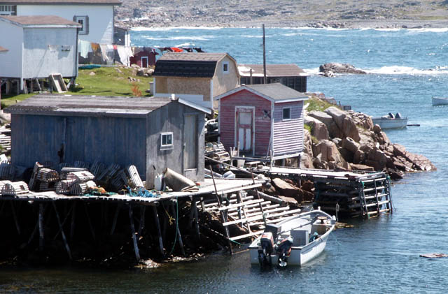
| | | | Let me give an example. When it's 12:00 noon, daylight time, in Newfoundland and adjacent Labrador in its half-hour offset system, it's 11:30 in upper Labrador, which is in the local, regular time zone, also on daylight time. But Blanc Sablon QC, also in that same local regular time zone, stays on standard time, and it will be 10:30, the same as it had been in New York on daylight time. | | | | To use real numbers, when I fly out of Saint Anthony in northern Newfoundland across the Strait of Belle Isle at 11:55, it's a 25-minute flight, and on my watch I land at 12:20 in Blanc-Sablon. But the arrival time is listed as 10:50, local time, 1.5 hours earlier. If it takes me an hour to pick up my rental car, look around, and drive a few kilometers to the Labrador border, locally in QC it's 11:50, but as I cross into Labrador it'll be 1:20. Worse, when returning, I'll have to be very careful to arrive in time to catch my flight based on Québec time. An hour's difference one can get used to, but that extra half-hour offset . . . And by the way, when I get off the plane, it goes on up to Goose Bay in upper Labrador, where it arrives at 12:55 local time, which back on the island would be 12:25. Crazy! | | | | Currents, Icebergs, Grand Banks We'll use this map of coastal currents to show the currents that sweep down from Greenland and the Labrador Sea, ending with the Labrador Current, along and around Newfoundland. As we discussed in Greenland, about 90% of the icebergs in the North Atlantic come from glaciers on the west coast of Greenland. Of about 40,000 medium to large icebergs Greenland produces a year, depending on wind, air temperature, and water temperature, 400-800 reach the area of Saint John's, usually in the spring and early summer, moving about 17 km (11 mi) a day. The dense fog in the area makes the hazard even worse for shipping and off-shore oil platforms. | | | | The Labrador Current coming south meets the Gulf Stream going north at the Grand Banks (Map by Treeman), a group of relatively shallow underwater plateaus southeast of Newfoundland, forming a part of the continental shelf. The cold water coming south mixes with the warm water going north and they lift nutrients to the surface, forming one of the richest fishing grounds in the world. This is what attracted the Portuguese, Basques, and others to the area in the first place. However the warm/cold blend also can cause dense fog, and the Titanic sank at the lower end of the Grand Banks (2012/24). | | | | Coastal Lineup My impression of the various areas lining up along the coast of North America (Map by Kmusser) is this. I see three regions, New England and the Maritimes together, Newfoundland & Labrador, and Greenland. New England and the Maritimes, which to me are very similar in nature, are the most accessible to Canadians, Americans, and others by all modes of transportation, and have a huge amount to offer, not the least of which is the Maine and Nova Scotia coasts. The Michelin guides to these areas are rife with three-star destinations, the top rating. After this up the coast, after the Gulf of Saint Lawrence, comes Newfoundland, much more remote, reachable by sea or by air. I like Newfoundland, which is why I'm going back, but its charms are more laid-back than its neighbors'. My Michelin Canada guide shows nothing higher than two-star destinations in all of Newfoundland & Labrador, although newer versions do give (only) Saint John's three stars. | | | | Beyond Newfoundland is the Labrador Sea and Greenland, even more remote, with much more of an atmosphere of an Arctic frontier. Though Newfoundland has a lot of open space, and has a lot of remoteness, it's still more "normal" than the frontier atmosphere of Greenland. The area of the Avalon Peninsula is where most of the interesting locations are, but then you can also crave that remoteness, which is why I'm going north before returning to Saint John's. | | | | Locations and Former Visits I've been lucky with maps, and I've found a beautiful, detailed one to review locations in Newfoundland and Labrador. Start at the top to get an impression of how large upper Labrador is, and how a long extension of Québec province reaches out south of it. If you're a glutton for punishment for driving huge distances through the wilderness, you can come up the Saint Lawrence to the mouth of the Saguenay Fjord, and from Tadoussac continue upriver to Baie-Comeau, where a road then leads inland to connect to the Trans-Labrador Highway in an arc to Labrador City and Goose Bay (now called Happy Valley-Goose Bay). In 2009, it was extended to Cartwright on the coast to connect with an already-existing part of the highway all the way via Red Bay down to Blanc-Sablon, just over the Québec border (not shown on this map). However, no highway in Québec goes much further back west than that, and it's quite some distance to Route 138 on the map. Therefore, Blanc-Sablon ("White Sand"), which is easily the easternmost community in the province of Québec, de facto has more to do with Labrador. It's also connected by ferry to St Barbe in Newfoundland, but it was too awkward for me to use that route. The Trans-Labrador highway between Blanc-Sablon and Red Bay, where I'll be going, is paved. Beyond that it's gravel. | | | | But the south shore of Labrador is my second stop, not my first. My first stop out of New York via Saint John's is the area near Saint Anthony and its airport at the top of the Great Northern Peninsula in Newfoundland, actually around Ship Cove. This is the area of L'Anse aux Meadows on the Strait of Belle Isle. You can see Belle Isle ("Beautiful Island") itself on the map at the entrance to the strait. From here it's Labrador next, then a few days down in Saint John's, all by flying Provincial Air. | | | | This will be, on real terms, my second visit of any length to Newfoundland, but technically, it's my fourth. Two that I did from Europe were fleeting and hardly count. I just count the two starting in North America. Let me explain. | | | | In 2012/21 on Iceland, I explained how, in 1962 on our “wedding flight” back from the year in Mainz, we left Luxemburg to Reykjavik, then flew from Reykjavik to New York, and later on to Minneapolis for the wedding. That second flight, as was usual at the time, stopped in Gander for refueling, so that's my first visit that doesn't really count. The real first visit was a week in 1984. Then, in the third week of July 2000, on our first trip on the Deutschland, we stopped again. It was a short transatlantic crossing inasmuch as it went in three days from Ireland to Newfoundland. We stopped for a few hours in Saint John’s so that's the other trip out of Europe that doesn't really count. The two "real" trips are the week in 1984 and the ten days now. | | | | In late June/early July 1984 we drove through New England and the Maritime Provinces up to Sydney (see map) to take the overnight ferry to Argentia. After visiting the Avalon area, we then drove counterclockwise to Port aux Basques for the shorter day ferry back to Sydney. | | | | The Avalon Peninsula itself, with its concentration of population, also has a larger variety of things to see and do than the rest of the island. The peninsula looks something like a four-fingered hand at the southeast corner of the island. Coastal fishing villages and occasional icebergs can be seen here as well as anywhere else. We stopped at Placentia and spent time in Saint John's. As a matter of fact, we saw our first iceberg ever there, a tiny thing that had found its way into the harbor. We visited the charmingly named Heart's Content on the east shore of Trinity Bay (not shown), with the Heart's Content Cable Station NHS, where the first transatlantic cable came ashore, laid in 1866 by the SS Great Eastern herself. | | | | There are two peninsulas framing Avalon. The one on the east side is the Bonavista Peninsula, viewable on both maps, where Cabot came ashore. The village of Trinity is charming, and we also went out to Bonavista to the lighthouse. To see the peninsula behind Avalon on the west side you have to look at the bigger map, where you'll find the Burin Peninsula. This is the point where we temporarily left Canada for a night. | | | | You see the ferry near the end of the peninsula that goes out to Saint-Pierre. Ask most people what political entities there are in North America north of Mexico and they'll name two, the US, with Alaska, and Canada. Most don't realize that France is in North America still, in the entity called Saint-Pierre et Miquelon. It's part of France, the inhabitants speak metropolitan French, with some local variation, not Québec French, and at the time they used, not the Canadian dollar but French Francs. Today they use euros. Miquelon is the large double island on the map. Saint-Pierre is the name of both the smaller island and its main town. We parked the car and took the two-hour ferry to Saint-Pierre for a night. There was a lot of fog on the way and once there, but the town had a very small-town French feel. The ride back the next day also saw some fog. [While Newfoundland Daylight Time is UTC -2.5, Saint-Pierre daylight time is UTC-3, the same as upper Labrador, one half-hour earlier, so even that ferry ride crossed a time zone.] | | | | Michelin lists many sights in the Avalon area, but beyond that, only two national parks and L'Anse aux Meadows, all with just two stars. The red road on the big map is the Trans-Canada Highway, which was also roughly the route of the former, lamented narrow-gauge Newfoundland Railway that ran from 1898 to 1988, with passenger service ending two decades earlier (more when we visit Saint John's in the next posting). We stopped quickly at Terra Nova NP, and took a look at Gander Airport where we had stopped years earlier. | | | | At Deer Lake we left the TCH to stop at Gros Morne NP, which lies at the bottom of the Great Northern Peninsula, to see upland views and to drive along the South Arm to Bonne Bay with its fjord and fishing villages. It was there that I had a memorable experience. Rather than drive the long way around to the north side, we wanted to cross Bonne Bay on the tiny ferry that carried just a few cars. But as we drove up, it had just left. When they saw us arrive, they stopped, backed up again to the dock, reopened the gate, and let us board. It was one of our nicest memories. [I am now advised that the ferry now takes only passengers and no cars.] | | | | It had earlier been our intention to go see L'Anse aux Meadows at the top of the peninsula as our last stop, but we then realized we had grossly miscalculated the large distances in Newfoundland when planning and didn't have time. We were already maybe 100 km (62 mi) off the TCH at Deer Lake, but the entire distance from the TCH to L'Anse aux Meadows is 438 km (272 mi) one-way. The next morning we were to leave Newfoundland on the ferry, and we already had motel reservations near the ferry. It was early afternoon, but we realized it was impossible to drive all the way up, see the Norse restoration, come back down to the TCH, then proceed to Port aux Basques. | | | | What we did do, since it was after all only early afternoon, was to drive a bit further up the coast to see what the ocean views were from the Great Northern Peninsula. Still within the bounds of Gros Morne NP, we stopped 32 km (20 mi) up from Bonne Bay where we found, serendipitously, something else that was memorable, and which made a good turning-around point. The road ran along the shore, and the views were westward over the choppy waters in the sun. Suddenly there was the rusted wreck of a ship not that far offshore, with a historic marker. | | | | It was the remains of 1919 shipwreck, the first time I'd ever seen a ship's bones left protruding from the water. I mentioned this experience up in Churchill, where there are two other shipwrecks that have been left to the elements. I didn't note down details at the time, but present research now tells me that this ship was the SS Ethie, built in Glasgow in 1900 at 47 m (155 ft). I was surprised to see that the Ethie was used up the peninsula, on the run we mentioned between Saint Barbe and Labrador. But on 11 December 1919 she was here downcoast when she sank. Apparently, passengers and crew were dramatically rescued by means of a bosun’s chair and a rope. | | | | So the memorable Ethie was our northernmost point in Newfoundland, and the Norse restoration was out of reach. It remained that way from 1984 until now. Not only having to skip it years ago, but also the lengthy discussion of Norse expansion, the visiting of so many places related to it on the Deutschland last summer, plus the impracticality of going back to Greenland to the Eastern Settlement made this the time for the return. And this time, I'm flying up from Saint John's to avoid that huge drive. | | | | Outports Before there were many highways, including the TCH, before there were the railroads, it was ships that were needed to reach the numerous isolated coastal communities of Newfoundland. They're called outports (Photo by carib). Even "port" in the name implies access by water, and the "out" implies being located away from the chief port of Saint John's. They are some of the oldest European settlements in Canada, many having been established by Portuguese, Basque, French, and English fishermen and whalers between the 16C and 19C. They consist of small wooden houses with outbuildings, and fishing stages, all at the water's edge. A fishing stage (Photo by carib), associated with cod fishing, is a wooden building that consists of an elevated platform on the shore with work tables and sheds to land and process fish for salting and drying. The Tickle Inn I'm staying in on my first stop in Newfoundland this trip was an outport home and, as David claims, along with the adjacent house, it's probably the northernmost residence on the island and apparently the oldest house on the Great Northern Peninsula. | | | | Newfoundland English The language mix in Newfoundland reflects its history. It has a dialect of English known as Newfoundland English, a dialect of French in a small area known as Newfoundland French, and once had a dialect of Irish known as Newfoundland Irish, but that has now disappeared. That Newfoundland English should be a separate dialect should not surprise, since it is one of the oldest overseas communities of the English-speaking world, and it has evolved and developed in semi-isolation for about half a millennium. While it's still a type of North American English, its roots are mainly English, Irish, and French. David Adams said a few things in Newfoundland English at dinner one night to illustrate, and we all found it quite incomprehensible, although as always, once it was explained, you could often more easily understand why it meant what it did.
| | | | While every region of every language has variations in vocabulary, pronunciation, and grammar, there is a Dictionary of Newfoundland English that's about the size of a regular English dictionary. It's also possible that the pronunciation nu.find.LAND is a manifestation of Newfoundland English and is not necessarily something to be imitated generally elsewhere. | | | | This is the online version of the Dictionary of Newfoundland English. You may want to take a look at the introduction, and then go to the A-Z index and just troll for words. If you look up "outport", for example, you'll see that there's a cross-reference to the Oxford English Dictionary, which even localizes the word as "Nfld" dating from 1820, explaining it's "A coastal settlement other than the chief port of St John's." There are a number of references in the dictionary to the OED and many of these words have a maritime flavor typical of Newfoundland history. I've been advised by David that, also reflecting the remoteness of Newfoundland history, many of the words in Newfoundland English are local, and even many Newfoundlanders will understand only a small percentage in the dictionary. | | | | I like the word "landwash" largely because of its origins. It's "The sea-shore between high and low tide marks, washed by the sea", and derives from "land awash", or land that gets regularly flooded. David also tells me that by extension, it can refer to any beach, even above high-tide line. | | | | I also have some regular words with special uses. Normally, a jib is a kind of sail, which is reflected in the Newfoundland good luck wish "long may your big jib draw". I shouldn't have been surprised when David had this phrase on the card he gives out when one pays the bill. But it's also uniquely used to mean "A small parcel of land, irregular in shape." A 1960 quote from a newspaper says that "The site is rather small . . . and . . . it will be necessary to acquire an additional jib of land." | | | | The other example I want to use of a regular word used uniquely involves me actually having had to look up a word in the Newfoundland dictionary. My first stop, as mentioned, is called the Tickle Inn. The dictionary told me that in Newfoundland, a tickle is "A narrow salt-water strait, as in an entrance to a harbour or between islands or other land masses, often difficult or treacherous to navigate because of narrowness, tides, etc; a 'settlement' adjoining such a passage." If I may speculate, I suspect that the element of danger that comes up in an expression all English speakers use, "a ticklish situation", might have led to the word "tickle" being used this way. But David further advises that nowadays, danger I not a necessary element, and any strait can be called a tickle. He also told me that he meant for there to be a double meaning in the name, since "to tickle" can also mean to please. | | | | This concludes the introductory remarks on Newfoundland and Labrador. Subsequent postings will describe the 2013 visit in detail. | | | |
| |
|
|
|

