|
Reflections 2013
Series 1
January 11
Canadian Trio I: Saguenay - Saguenay Fjord - Val-Jalbert
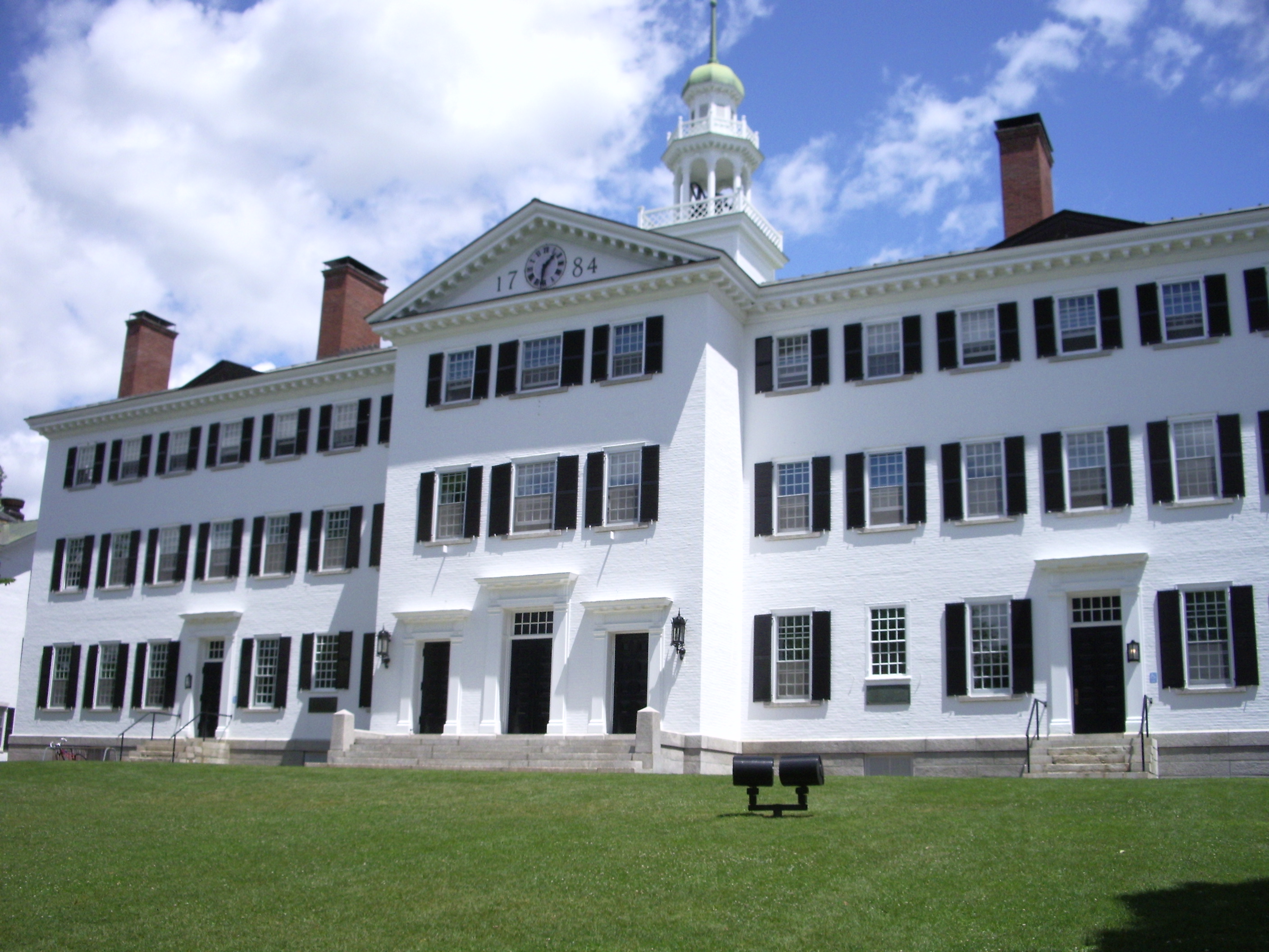
| | Looking back to the essays covering 2012, I now realize how long the "Atlantic" topic lasted. It started with the discussion of the ocean itself, and continued to the start of the Atlantic Isles trip up to Germany. Since the second half of the Isles trip involved Scandinavia, we took an extended detour about the Norse, in all directions, including influence on the English language, before returning to the end of the June trip through Greenland. Except for the marriage topic of the first essay, the entire year was devoted to the extended Atlantic topic. | | | | That means that the time taken to discuss the June Isles trip totally prevented writing about the September Canada trip while it was happening. That trip was partially meant to see the early autumn leaves in Canada, and we are now an entire season behind that. But there's no time like the present to start catching up. | | | | Fighting the Bustitution War I have recently had three instances of bus service temporarily replacing scheduled rail service, jocularly referred to as "bustitution". I won two battles (in the long run) and lost one (but will come back to fight again). | | | | A BUS OR THE VERMONTER In 2011/23-24, in the third of the New England Thrice trips, I took the Ethan Allen to Vermont, traveled around the area and into Canada, then returned to Saint Albans VT to take the Vermonter back to New York. The bustitution because of upgrading the line was supposed to have been done, but was not, and I wasn't about to take a bus when the whole point was to experience the train, so I drove to Burlington Airport and flew home, not having completed what I'd intended to do. At the time, I channeled General MacArthur in 1942 leaving the Philippines by saying "I shall return". It took him two years before he could announce "I have returned", but he had a World War to contend with. It took me just six days less than one year to be standing in Saint Albans again. | | | | Rather than flying back to Burlington in late August, it was much simpler to simply go up by the Vermonter in the first place, stay there a while, then come back the same way, stopping to visit friends. Amtrak's Vermonter runs 983 km (611 mi) from Washington via New York to Saint Albans VT, once daily in each direction. If it seems odd that its route should suddenly end in a small—though pleasant—town, it's that the train used to be called the Montrealer, and offered through service overnight beyond Saint Albans to Montreal, making it an alternate east-of-Lake Champlain route between New York and Montreal to complement the Adirondack doing the same to the west of the lake. But budget cuts threatened the Montrealer and the state of Vermont offered to subsidize the section within Vermont, hence the name change to Vermonter. Numerous financial and international labor reasons caused the missing section to at first be replaced by a bus (!!!) link, which proved uneconomic, so the route now ends at Saint Albans. However, I heard from two people in Saint Albans, plus a rail official in White River Junction, that plans are afoot for a through train. In addition, all border formalities for both countries are scheduled to take place in Montreal's Gare Centrale/Central Station, on arrival northbound and on departure southbound for this train and the Adirondack as well. However, I have no updated information as to the final details. | | | | I met the Vermonter coming up from Washington in New York's Penn Station. I'd traveled the Washington route many times, and actually, I've already been on the route north of New York up to New Haven (see map above), so the terra incognita for me (at least by train) was the northbound segment beyond New Haven. We soon were near the Connecticut River, and had a major stop in Springfield, Massachusetts, then continued up between Vermont and New Hampshire. At White River Junction VT, we left the Connecticut River to continue diagonally along the White River from eastern to western Vermont, and arrived in Saint Albans in the evening. It was a short walk from the station to the bed and breakfast inn, in a Victorian mansion, where I'd stayed the previous year. It dates from the 1850's and its common rooms and upstairs bedrooms are filled with antiques. Take a look at the website for "Back Inn Time", run by Pauline Cray, and see how attractive it is, and why I think the two main criteria for a place to stay when doing serious travel is charm and location, and this inn is right in town, walkable from the station; when I drove last year it was also easy to reach and had plenty of parking. | | | | I stayed two nights. I recall three interesting conversations. On arrival, I met a gentleman interested in rail, but who wasn't familiar with rail gauge problems, particularly in Australia, but was interested, so I filled him in. The next day, writing at the dining room table, I chatted with a teacher from a small town in upstate New York near the Canadian border. Later that day, Pauline and I had a long talk about how she came to find, restore, and run the inn. This is one of the things travel is all about. I worked in the dining room (free wifi) much of the day, then took an extensive walk around town. | | | | The next day, after an early breakfast, Pauline was kind enough to drive me down to the Saint Albans Station, where I was a bit early. There were only a few people waiting—the train filled as we progressed—but I have to admit I had a funny feeling being "down by the station" on this bright, sunny late August day "early in the morning". It struck me that I'm very familiar taking trains in big-city rail stations, and have little to no experience in small-town stations—I'd have more shortly in White River Junction—and it just seemed unusual enough to that that song popped into my head, over and over. It was written in 1948, recorded by Tommy Dorsey, and had a renaissance in 1960. It has since shifted audiences to become a children's classic, but it still seemed so appropriate to me in Saint Albans. Here's "Down by the Station". | | | | Now don't get the wrong idea. The video shows an antique station and an antique museum steam train and gives an old-timey flavor, while the Vermonter (Photo by reivax) is a modern Amtrak train. Yet the song seemed appropriate. | | | | I had missed seeing much of the upper end of the route because of darkness, but it was beautifully sunny going southbound. My goal that day was to do what I'd had to postpone the previous year, visit friends Paul and Marya. I got off in White River Junction, which had once been the most important railroad community in Vermont. It had five different railroad lines intersecting here with trains arriving at an eight-track crossing serviced by 50 passenger trains a day. It now has only the Vermonter plus an excursion train or two. But rail is reviving, and we shall see what we shall see. | | | | This is an 1889 view of White River Junction (click to enlarge) as seen from across the river in New Hampshire. The Connecticut River is flowing from the north on the right, to the south on the left, and the view is west up the White River. Train lines are visible coming from all four directions, but today it was only the Vermonter, and it pulled into the WRJ Station (Photo by Mickmaguire), which also had a museum train on display. Paul met me, and we took a stroll through the WRJ historic district. | | | | We drove over to New Hampshire, where Hanover, the home of Dartmouth College is, in order to visit Lyme, where Paul and Marya have their house. We took a walk through Lyme, and later through nearby Orford, on the river, to soak in the country atmosphere. I suggested we walk onto Bridge Street, and walked out halfway across the bridge over the Connecticut River. While we were deep in conversation, we admired the views up and down the river, resulting in a pleasant outing. | | | | Only afterward did I realize I'd lost an opportunity. I've been keeping track of the very few places I WALK over borders, and shortly after this bridge visit, I did so again in Ottawa. But deep in conversation, we neglected to actually walk into Vermont, and stayed on the New Hampshire side. Even as we arrived halfway over the bridge, I might have reluctantly considered it an interstate walk, although I would have been much happier if I'd thought to continue to walk to the other end of the bridge. But even that doesn't work, since the VT/NH border doesn't run down the middle of the river, but along the Vermont shore, putting the entire river into NH, so there's no doubt that walking all the way across the bridge would have been necessary. A lost opportunity. | | | | Lyme lies just north of Hanover NH, home of Dartmouth College. It was the wheeler-dealer Royal Governor of NH, Benning Wentworth (details in 2011/23) who gave out land grants in both VT and NH to fill his pockets, who had a busy year in 1761. That year, he chartered Hanover NH on 4 July, nearby Lyme on 8 July, and Middlebury VT on 2 November, making Middlebury four months younger than Hanover. Eight years later, in 1769, Dartmouth College was established in Hanover. Dartmouth, where Daniel Webster was a student, is one of nine Colonial Colleges founded before the American Revolution. In age sequence, they are: Harvard, William & Mary, Yale, Princeton, Penn, Columbia, Brown, Rutgers, Dartmouth. All but William & Mary and Rutgers, which are public universities, are in the Ivy League, as is Cornell, which is younger. Dartmouth is the smallest, and youngest, in the Ivy League. | | | | Beverly and I first visited Hanover and Dartmouth in the summer of 1977, on a day trip out of Middlebury, where we were studying, but this time, I took a long walk around the campus with Paul, who had attended Dartmouth. This is a southern view of The Green (Photo by Kane5187), with Hanover Inn on the right and the Hopkins Center for the Arts on the left. The Green is the only 18C creation remaining at the center of the campus, inasmuch as the 1784 Dartmouth Hall (Photo by Kane5187) on its east side burned in 1904 and was then immediately replaced with this reconstruction. The next morning we drove back right across the river to WRJ for my return ride on the Vermonter to New York.
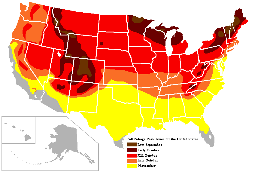
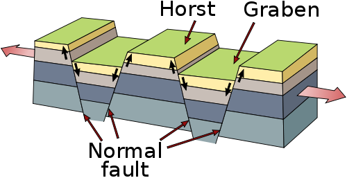
| | | | A BUS TO GASPÉ/PERCÉ Just over three weeks after returning on the Vermonter, in the latter half of September, I was back at Penn Station to ride the Adirondack to Montreal, but for plans that had needed to be altered. I had had three destinations I wanted to visit by rail in Canada, and one of them was the only overnight train on VIA Rail I hadn't traveled on (Churchill had been the next-to-last), from Montréal to the Gaspé Peninsula in Québec (Province) to see the town of Gaspé, moreso the peninsula, and particularly Percé, where the huge pierced monolith stands just offshore. I'd been there twice by car in the past, and going by train would be a nice re-visit. I had then discovered that old story, that the far end of the route was under construction, and there was a bus replacement for the last five hours (!!!) of the trip. I kept on calling to check if the work would be done in time for a September visit, but apparently that was a false hope. So this bus replacement was a defeat. I'll do it sometime in the future, and instead found a nice alternative, the all-day train to Saguenay, to add to my planned revisits to Ottawa, and to Québec (City). But, once again: I shall return. | | | | A BUS FROM QUÉBEC (CITY) Finally, when coming back on this Canada trip from Québec to Montréal with a ticket for an early afternoon train, I got to the Québec station to find that the incoming train had had some sort of minor accident on the way up and wouldn't arrive in time for my departure, which was therefore being replaced by a bus!!! Fortunately, there are several trips on this route a day, and I had considered this day just a travel day anyway, so I rebooked for the late afternoon, and stayed at the station writing and having an early dinner until my train left. So this was a bus battle I won. Two out of three isn't bad. | | | | Canadian Trio As it turns out, the Canadian Trio trip would be to Saguenay, Ottawa, and Québec. No matter what, all three were reachable out of Montréal, so it was thither that I set out from Penn Station the third week in September on the Adirondack, up the Hudson Valley, past Albany, and along Lake Champlain. It's an eleven-hour trip to cover the 613 km (391 mi) from its start in New York (not in Washington, like the Vermonter), and while there has been talk of high-speed trains on this route since 2005, to our shame, nothing has come of that. | | | | We were at the border for 50 minutes, although we did get into Montréal 15 minutes early. The Canadian officials came on board (on the return, US officials did the same) interviewed everyone, and then selected several random victims to deboard with their luggage for further inspection. I always feel a slight shudder when I see that, since it reminds me of the Gestapo's random selection of victims to march off. I wish these officials would do their checking on board, for the peace of mind of my imagination. | | | | As usual, there was an item of friction at the border. I always travel very light. I have a mid-sized wheeled bag for longer trips, which is what I took for six weeks around the Atlantic, since I don't need many clothes, as rinsing out wash-and-wear items in hotel sinks is so simple. I might have needed even less space, but I schlepped my tux all around the islands until sailing on the Deutschland, just to wear on three evenings. But to Canada, I simply took my small wheeled bag, and it was more than adequate. It was on the empty seat beside me, as I was typing away. The customs official asked me the usual boring questions, including where I was staying (assuming one doesn't travel around) and how long I would be in Canada. When she asked where my bags were, I pointed to the small bag next to me, and she sincerely said to me that that's not enough luggage for eleven nights, so where's the rest? I felt like telling her, if she doesn't know how to pack a bag properly, she shouldn't be giving travel advice, but thought the better of it, and she eventually accepted what she saw and moved on. I'll be glad if they move customs inspection to the station in Montréal. | | | | The Adirondack arrived in the early evening at Montréal's Gare Centrale / Central Station, which 18 million passengers use every year. Central Station is the second-busiest Via Rail station in Canada, after Toronto's Union Station (2011/27), used by 65 million annually. This is the station's Main Concourse (Photo by Pascal Normand) one morning. The board displaying arrivals and departures changes every few seconds between English and French. Click to enlarge to see that train 22 will be leaving at 13:00 from track 15 whose number you can see right below the board, where there is an escalator down one level to the tracks. You can see other track signs down through track nine, with 13 lit to show the 11:50 departure to Toronto is imminent (the clock says 11:45). I also include this next picture of the Concourse (Photo by Sandra Cohen-Rose & Colin Rose), because it's an evening view showing train 69, the Adirondack, is due to arrive from New York, and the joint trains from Jonquière and Senneterre, which we'll discuss in a moment, are also due soon. | | | | I left by the drive-in entrance to the station (Photo by Pascal Normand) located on the very French-sounding Rue de la Gauchetière, walked to the corner and turned two blocks down Rue University, a Canadian-hybrid name if I ever saw one, to my hotel. In the attempt to make street designations and signage French, which I feel is appropriate in Québec (Province), there is inconsistency. I just checked records, and in the English-language town of North Hatley, where I was last year, what had been Chemin University (chemin=road), was fully changed to Chemin de l'Université, while Montréal retains the odd hybrid Rue University instead of Rue de l'Université. It's a puzzlement. | | | | I had needed three separate one-night bookings of a hotel in Montréal to accommodate train schedules. I couldn't find a B&B or a boutique hotel near enough, so I chose the Delta Centre-Ville (=Downtown). It was a very good hotel, at a good rate, with good service (she remembered me at the front desk both times I came back) but was a large, boxy contemporary that fit right into the neighborhood of oversized boxes on Rue University (Photo by Alexcaban). Excellent hotel that it was, it had location, but little charm, yet it served its purpose. | | | | Montréal is nice, but as I wrote on my visit in 2005/6, much of it, particularly here downtown, is just these oversized, over-Manhattanized boxy contemporary buildings. On that earlier trip, I walked east to Vieux Montréal, the old part of the city that's been restored, with older buildings recycled, an area that's on a human scale, with squares with street life, charming restaurants, historic houses. Montréal is one of those presumably very liveable cities where the visitor nevertheless has to search for charm, since it isn't everywhere. | | | | Foliage One reason to pick September to go to Canada is because of the earlier foliage change than we're used to in the northeastern US. This is a travel topic worth discussing. | | | | Japanese culture is known for the love of nature—think of the springtime cherry blossom festival—and the Japanese call searching out beautiful fall foliage momijigari, a word which by itself denotes charm. From what I read, momiji means both "red leaves" and "maple tree", which already is an interesting combination of language and philosophy. Kari, which appears as gari, means "hunting", so the autumn activity of momijigari means "hunting red leaves" or "hunting maple trees". While visiting Japan in the spring for the cherry blossoms would be one ideal, I was fortunate to have visited Japan in the autumn (2009/35-42), where there was extensive opportunity to see autumnal leaf color. Nikko and Kyoto are listed as particularly famous for this, and I clearly remember the tree color in both those places. | | | | A common term for this activity in the US is "leaf peeping". Foliage changes color to some extent anywhere deciduous trees are found, but the online list I find points out that the brightest colors appear these four areas: Europe north of the Alps; the Caucasus near the Black Sea; East Asia, including northern and eastern China, Korea, and Japan (!!!); and the northern US, particularly New England (Photo by Strongblad1982), as well as adjacent southern Canada. North America has a particularly large number of trees that change, 800 species, including about 70 oaks, while western Europe has 51, including 3 oaks. The map shows peak color times in the US, with upper New England falling in late September. I don't have a corresponding map for Canada, but written sources I found discuss mid- to late September as well. So, for the earliest color change, Canada it was to be, with further inspiration for seeing the momiji / red (maple) leaves provided by nothing less than the stylized, 11-pointed red maple leaf in the Canadian flag, adopted in 1965 to replace the Union Jack. Later, when I was in the gift shop of the Canadian Parliament in Ottawa, they had for sale nothing other than genuine red maple leaves sealed in acrylic. Canada in September was particularly appropriate, and a no-brainer. | | | | Trains to the North It's time to explain the change in the long-distance route I had to replace. This is the website of VIA Rail Canada. Click on the thumbnail map on the right to enlarge it. These are all the routes run by VIA. Four of them are overnight trains, "overnight" being my criterion for a more substantial trip as opposed to a day trip. I have ridden three of VIA's four overnight routes. | | | | Red is the Canadian, which I've ridden many times, including on the former southern route through Banff, instead of the current northern route through Jasper. One yellow line goes to Churchill, which I rode in 2011, including connecting to the Canadian. Light blue is the train to Halifax. I'd driven to Halifax twice before I took the train there (2005/6). Coming back from Halifax, I took the train from Montréal to Toronto, then the Canadian to Vancouver, from which I continued my Round-the-World by Rail trip. In other words, Canada coast-to-coast by rail was the North American part of that trip, added to Eurasia by rail. The fourth overnight train is to Gaspé, in green, which is the one I now had to skip because of the bustitution. Current talk is that, if there is funding to do the repairs, which is in doubt, it'll still be quite some time until it's ready. | | | | I've also done day trips, which I've now supplemented with the Canadian Trio trip. On one trip on the Canadian, we got off in Jasper and took the train to Prince Rupert in order to take the ferry to Alaska. The dark blue lines are the Corridor trains which run frequently between Québec (City) and Windsor/Sarnia. In addition to the connection I just mentioned, I've been on the Maple Leaf (!!!) to Niagara Falls and New York (the Adirondack is also shown in dashes). On this Canadian Trio trip I did Montréal-Ottawa and Montréal/Québec. I also did Montréal/Jonquière (Saguenay), a name that will be explained below. Note also the twin Senneterre train, which is actually the other half of the train I took. | | | | When I had to replace the Gaspé train for this trip, I went back to reconsider these two day routes I'd previously ignored. They both had been overnight trains until 1996, but there is no longer enough ridership to include sleeping cars. As a matter of fact, they run only three times a week now. At first they both sounded uninteresting. The train to Senneterre went to the Abitibi region, known for agriculture, forestry, mining of gold and copper, all of which seemed to no interest to a traveling visitor. But then I realized that the one listed as going to Jonquière actually went to the Saguenay Fjord, well worth the trip, and the route through the woods, particularly in autumn, would make the trip quite worthwhile. | | | | The Train to Saguenay (Jonquière) The combined train left Montréal in the morning. When we got down to the platform, I was directed to the Jonquière segment up front, which had a diesel engine, one large, somewhat dated, but quite comfortable coach, and an unbelievably large, and quite empty baggage car. Connected to that was a second engine, coach, and baggage car, which was destined for Senneterre. The train would split en route at Hervey-Jonction. | | | | As it turned out, my route was the original one, built in segments. The middle segment from Rivière-à-Pierre to Chambord, on the large Lac Saint-Jean (see below), was built first, in 1888, then extended to Jonquière in 1893. The southern section was built in pieces starting in 1898, reaching Montréal in 1994, just as the northern region was starting to boom, largely from lumber and paper mills, of which I visited some interesting locations once in Saguenay. As it turns out, the Senneterre segment was built as a later branch, from 1908-1913. | | | | My route covered 510 km (316 mi) and took the whole day, until late afternoon. It was only 71% of the length of the other route of 717 km (445 mi), which arrived after dark. There was a café corner on the coach where the conductor sold snacks. | | | | After Montréal, the route was forested all the way and I certainly saw my share of autumn color, along the tracks, across streams and along lakes. The route had the occasional parallel roads and crossroads, with small settlements, but was quite sparsely inhabited (though not to the extent the Churchill route was). There were several kinds of stops. The scheduled stops were only those shown on the map, plus two others near Montréal. | | | | One kind of non-scheduled stop involves the fact that one of the oddities of this route is that it was built through the forests to accommodate "Clubs". There are still request stops that correspond not to a station, but to a signpost, such as for Club Bélanger, Sisco Club, Iroquois Club. Up until 1978, these were private fishing and hunting clubs, with clubhouses off in the woods, often well beyond the train's route. They were then largely replaced by self-administered, non-profit zones and by outfitters’ lodges. There are still more than 35 outfitters’ lodges in northern Québec accessible just by train, with accommodations, meals, and guides, for those so inclined. | | | | Club-Triton station, just south of Lac-Édouard on the map, serves La Seigneurie du Triton, a 50-room hotel in the forest, 4 km downstream along the adjacent river. The Triton Fish & Game Club has had a clubhouse there since 1897. It was visited by Winston Churchill and several US presidents, but there are no roads or paths to it, and it can only be reached by water from the station. | | | | The printed route guide explained that other unscheduled stops can be made in many places deep in the forest, for both pickups and dropoffs. The schedule shows 21 locations where the train “stops on request when traveller is seen by train staff” and 14 indicated by “for a stop at this station, reservations are required at least 40 minutes before the train departure from the origin station”. In many ways, this knowledge of these possibilities gave one a thrill of traveling out in the wilds. | | | | The three last stops saw many locals get off, starting with Chambord, right after which we had the large Lac Saint-Jean to one side, a startling change to see lake views after coming out of the forest. In this view of the VIA Rail Station in Jonquière (Photo by LHOON), the train pulled in from the west, at the right, behind the clock. This is the Rue Saint Dominique crossing the tracks. A few blocks to the right (south) on it were the restaurants and night life Jonquière is noted for, and a five-minute walk to the left (north) brought me to the Gîte au P'tit Manoir, the B&B I had booked for its excellent location. It also had its own quirky kind charm. | | | | A gîte (rhymes with "meet", G like the J in déja vu) is a lodge, so the name would translate as the Little Manor Lodge. It was a converted 1952 doctor's home. Take a look at its website. Click on "Entrée" and see Madame, who ran the show, and her husband, who drove me to the station when I left. My room was on the upper terrace hidden by the tree. Click on "chambres" and see that they have geographic themes for the five rooms, which adds to the quirkiness. I stayed in Le Mexique, which had a large ceramic sombrero on the wall. The common rooms were pleasant, the breakfast good, and the garden in the back had a very impressive, high waterfall. For my car rental, there was plenty of parking. | | | | On arrival, being used to speaking English at the Montréal hotel, where I was glad to avoid the Quebec dialect of French, I ventured speaking a little English with Madame, which went over like a lead balloon. So, I spoke French, and Madame and others spoke Québecois, and I was surprised that I was catching on to the dialect. A little. As we say, on se débrouille / one muddles through. | | | | Local Geography We've used the terms "Saguenay" and "Lac Saint-Jean", so let's see where we are. The yellow area on this map is the watershed (Map by Karl Musser) emptying into the large Lac Saint-Jean, which drains down the Saguenay River into the Saguenay Fjord and into the Saint Lawrence. You can estimate the train route from New York via Montréal, itself on the Saint Lawrence, up to this area. This is a satellite photo of Lac Saint-Jean, with the river leaving from its northeast corner. The gray area on the right well away from the lake and south of the river is Jonquière. The Saguenay River (Photo by Thomsonmg2000), shown here past the urban area and well into the fjord, whose cliffs are visible, has a very high flow rate. Chicoutimi is the next urban area downstream from Jonquière, and from Chicoutimi to the end of the fjord at Tadoussac on the Saint Lawrence, a distance of about 100 km (62 mi), the river is tidal. As I learned at the National Park Visitors' Center, the high fresh water flow rate combined with the tidal quality of the river within the fjord makes the fjord (along with the lower Saint Lawrence) an arm of the sea. In actuality, the salt water lies below, while there is one meter/yard of fresh river water on the surface. This fresh water freezes in the winter, leaving the water below available for wildlife. Beluga whales breed where the Saguenay meets the Saint Lawrence, making Tadoussac popular as a whale watching site. The area is also known for minke whales and harbor seals. The river is historically a trade route that the original natives used to gain access to the interior of the land. | | | | Local Geology We cover a lot of topics in these postings, and geology is one which I've have to learn more about on the fly. As I was reading about the Saguenay region. two geological terms came up, and, to my surprise, they were German terms apparently used generally in the field of geology to mean “sunken area” and “raised area” in a geological sense. | | | | The terms are Graben and Horst. A Graben (GRAH.ben) is a trench or ditch, so now internationally, a graben (plural unchanged) is used in the geological meaning of "sunken area". While Horst usually describes a thicket or grove of trees, it also means an aerie, or high nest (an Adlerhorst is an eagle’s aerie), so now a horst geologically refers to a raised area. | | | | | | The short form of Graben is Grab, which means "grave", and is related to the English word.
In English, there is an archaic word related to Horst, which is "hurst", in the meaning of "grove". While we no longer talk about a hurst of trees, the word appears frequently in place names across the English-speaking world. In the New York area I can think of Elmhurst, Beechhurst, Bensonhurst, and Lyndhurst, and, with a spelling variation, Massachusetts has Amherst, with Amherst College. Fully understanding names like Elmhurst and Beechhurst clarifies how totally arboreal their meanings are.
|
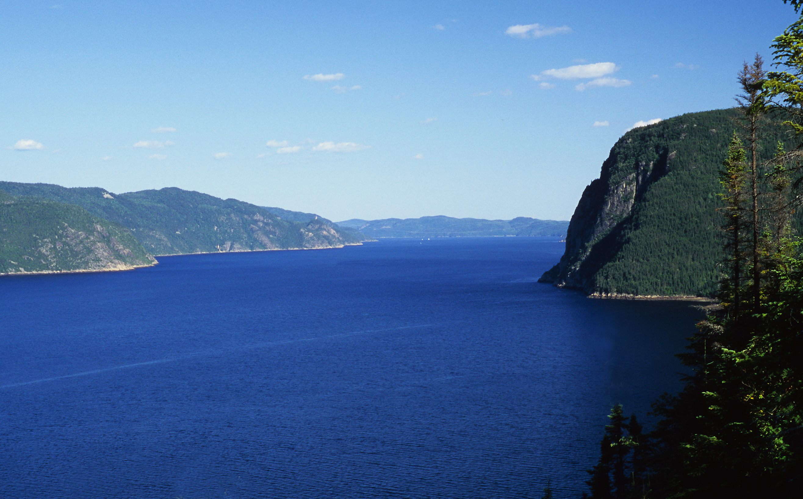
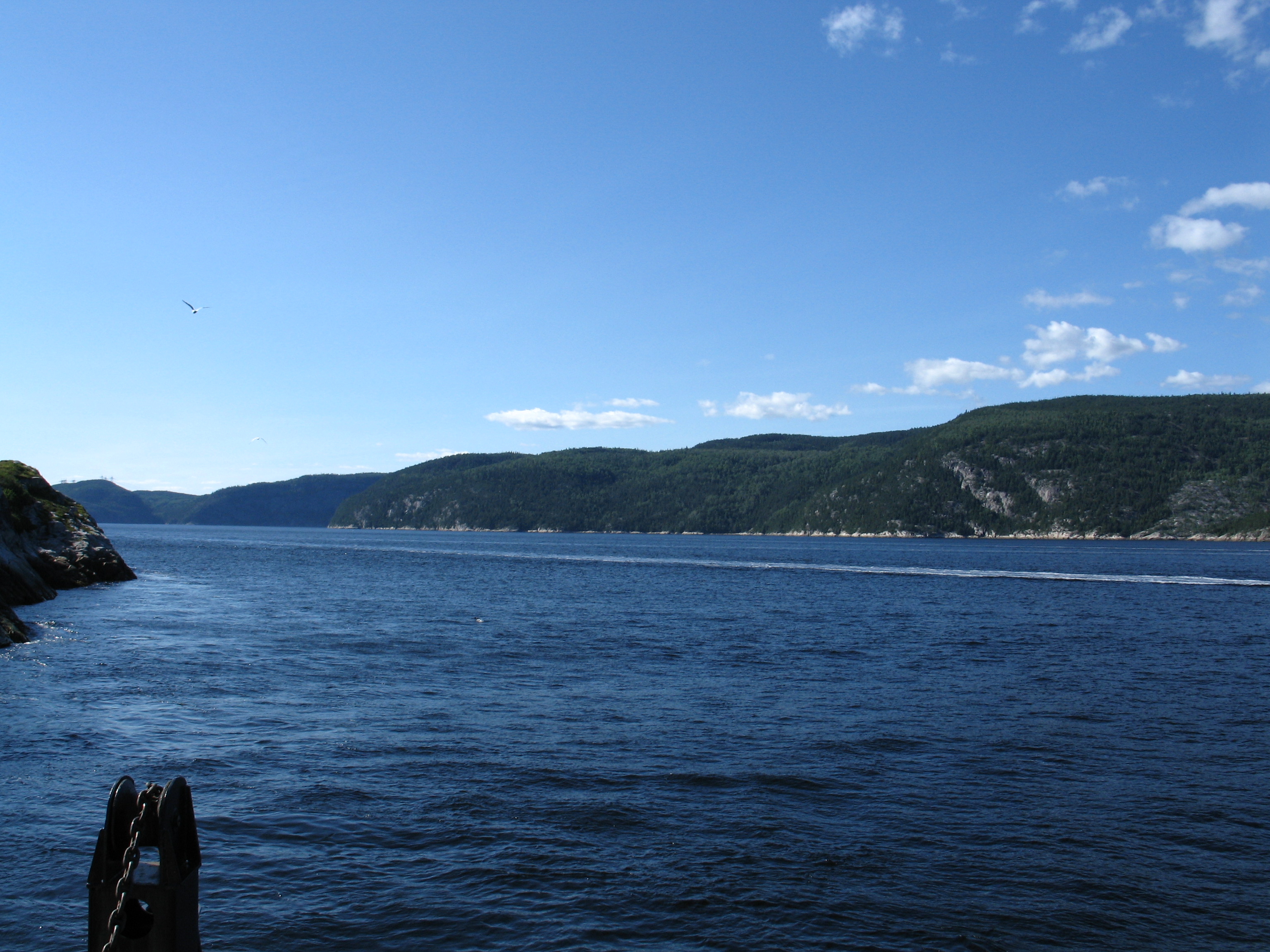
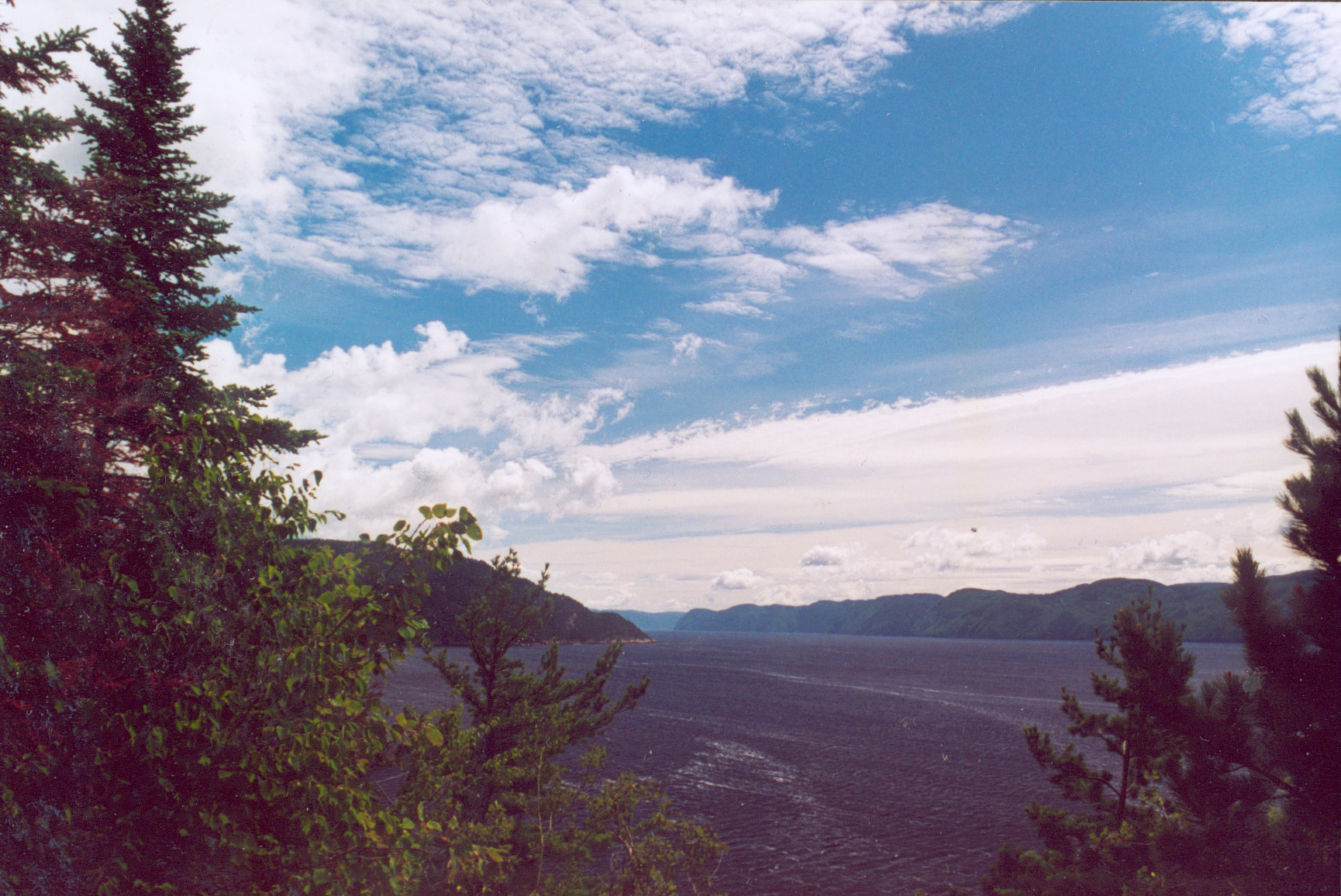
| | | | Picture bending a bread roll in order to tear it apart. The first thing that happens is that parallel cracks appear. When pressures pull the earth apart, the same type of parallel fissures appear. If enough spreading occurs, slippage might occur as well, and the land between two parallel fissures might drop down into the rift—and we have a graben forming between horsts. A graben will appear as a valley, typically with escarpments on either side, but don't confuse this yet with a fjord, carved by glaciers, or a canyon carved by a river. | | | | We've already seen pictures of a spectacular graben in Iceland, in 2012/21. The entire Þingvellir area is a graben, a point made then with reference ahead to this discussion. The pictures we saw from the visitor center, up on the horst on the west side, looked down to the valley and to the horst on the east side. This graben is part of the Mid-Atlantic Rift. And the Almannagjá, that pathway down from the horst (and parallel to it) into the graben, that was closed at the time because it was splitting apart even further, is—who knows—a potential mini-graben in formation. | | | | Understanding this concept allows us to group together numerous well-known places that are actually multiple examples of the same thing, graben: in the US, Death Valley, the Salt Lake Valley, Lake Tahoe, and the Rio Grande Rift (which is north of where the river becomes an international border); in Europe other than Iceland, the Rhine Valley north of Basel; the Oslo Graben; the Central Lowlands of Scotland; Lake Baikal and the Baikal Rift Zone in Russia; in Australia, Gulf Saint Vincent between Adelaide and Kangaroo Island; in Brazil, Guanabara Bay in Rio de Janeiro; the East African Rift (formerly thought to connect with other rifts, so that it used to be called the Great Rift Valley); and in Canada, the Saguenay Graben. | | | | So let's take a look at the Saguenay Graben and discover why and how part of it became a fjord. It includes all of Lac Saint-Jean with some of its watershed, plus the entire Saguenay River exiting it, which then enters the Saguenay Fjord. The entire graben is an elongated flat-bottomed basin 250 km (155 mi) long and 50 km (31 mi) wide. Evidence suggests that the faulting was caused by the opening of the Atlantic Ocean up to 195 million years ago, or even the opening of an earlier ocean up to 600 million years ago. The faulting in turn caused the bedrock between fissures to sink, creating the Saguenay Graben. The faults are still active and have been the source of earthquakes, including the 1988 Saguenay earthquake, of 5.9 magnitude, one of the largest recorded earthquakes in eastern North America in the 20C. | | | | Given the length of the graben, how did the lower part of the river's flow become a fjord? Normally, fjords aren't located inland, but are glacially formed along coasts, such as in Norway and Greenland. For this we refer back to 2010/25, which is all about the Laurentian Ice Sheet, that covered North America down into the northern US. The already-existing graben was located relatively parallel to the movement of the ice sheet and it became a travel pathway for ice. The glaciers cut into the graben and widened it in some places and deepened it in others. Lac Saint-Jean is small remnant of an original glacial lake of 10,000 years ago. And so the Saguenay area involves both the larger Saguenay Graben, which includes the lake, the river, and, in the lower river, the Saguenay Fjord. | | | | Municipal Consolidation Before we get into the rest of the Saguenay trip, we have to explain about the name of the local city, Saguenay, which is the result of municipal consolidation. In 1898, the cities of New York (Manhattan) and Brooklyn, along with surrounding towns, consolidated into one large city. Another example of interest is Berlin, where the 1920 Greater Berlin Act put the original Berlin together with seven towns surrounding it (familiar names might include Charlottenburg, Spandau, Köpenick) and numerous small communities to increase its area 13-fold and double its population. It was this large size that allowed the West Berlin to survive as an entity during the Cold War. | | | | In the US, consolidation can involve merging a city with its surrounding county. In other instances, smaller entities might merge into a new unit. Such amalgamation has also taken place extensively in Canada in recent years. Well-known cities that have expanded in size through consolidation include Toronto, Ottawa, Montréal, Québec, Halifax, Winnipeg, and others. That type of expansion is not immediately noticed by the unaware visitor. What does strike one is stumbling across less-famous consolidated areas that did not include a famous city in their midst. Or, if there was one town that was a bit more important then the others in the consolidation, perhaps because of local rivalry, its name was nevertheless not used and an entirely new name was chosen. In planning this trip, I stumbled across two of them in Québec, Gatineau and Saguenay, and online research found me one more in Ontario, Cambridge. There are other, smaller ones. | | | | Southwest of Toronto and halfway to London is the city of Cambridge, the result of a 1973 consolidation. It consists of the former city of Galt, plus two towns and a hamlet. Galt is still the largest area, taking up the southern half of the new city, but its name was not used. Instead, since the county had four townships, and this area fell within the former Cambridge Township, Cambridge was evidently the compromise name for the new city. | | | | The other two consolidations just mentioned both took place later, in 2002. I'd always been aware that Hull was the city across the river from Ottawa, but it's now called Gatineau. We'll discuss all that in the upcoming posting on Ottawa. So now we're back on topic, the ten-year-old city of Saguenay (Map by Chicoutimi). The gray areas around the lake and river are smaller municipalities, and the red area is the City of Saguenay. It was formed by consolidating the three principal cities (Map by Gilbertus) in the area, plus the four smaller entities named on the map. These seven areas are grouped back together as the three arrondissements of Saguenay, Chicoutimi, Jonquière, and La Baie. French cities are usually divided into arrondissements, a word that literally means "roundings", as though a circle had been drawn around an area to designate it. It corresponds to English "borough" or "district". | | | | La Baie is a beautiful residential area on its bay. Jonquière has its restaurants and nightlife, but the core of Saguenay was and remains Chicoutimi, whose site was first settled in 1676 as a French trading post in the fur trade. In the 20C, Chicoutimi and the region became a center for pulp mills. The train I took used to operate one stop further beyond Jonquière, into Chicoutimi. It still strikes me as odd that VIA still calls its last stop here Jonquière, and hasn't renamed it Saguenay. I suppose the best candidate of the three areas to give its name to the new city was Chicoutimi, but it's not that famous, and perhaps rivalry prevented that. As an alternative, you couldn't want a more logical name, given local geography, than Saguenay. | | | | Visiting Saguenay & Saguenay Fjord Now that the background is clear, we can visit the region, by driving around the fjord, which we'll do counterclockwise, since we're starting out on the south side of the Saguenay anyway. This was the second time I've done this, and it's so much more fulfilling to have all the background we've just discussed, particularly about the graben, so that there's more involved than just seeing pretty views. My first time here was, as usual, a day trip. In 1983, driving back from Gaspé for the second time (after 1980), we stayed at a motel across the Saint Lawrence, took the ferry across, encircled the fjord making stops, then continued down the Saint Lawrence on this side. This time I'd take a full day for the fjord, and use the second day to visit a location on Lac Saint-Jean that I'd chosen, as it turns out, quite happily. | | | | LA BAIE After breakfast the first morning, I had Madame help me call the car rental place, they came around to pick me up to go back and get the car at their location close to Chicoutimi (check previous map), and I was off to the first stop I wanted, La Baie. As I'd hoped, it turned out to be a charming neighborhood that might have once had a more resort-like character because of the bay. It was quiet and peaceful in town, and along the bay was a long bayside park. I drove along the length of the park, and then stopped for a short stroll to admire the view of the bay itself (Photo by Vanessa St-Gelais). | | | | But there's more to La Baie than charm and nice views. I'm sure the reader must have noticed a language issue coming up when they saw the name of the bay itself, the Baie des Ha! Ha! (Map by J.-P. Fortin), complete with not one, but two exclamation points. And beyond that, there's a Lac Ha! Ha! emptying into the Rivière Ha! Ha! (shown on the map) that empties into the Baie des Ha! Ha! branching off the Saguenay River at the inland entrance to the Saguenay Fjord. Apparently everything is named after the bay, but--what's it all about? | | | | Forget about laughter. That's another "ha ha". The one we're talking about, usually without exclamation points, and possibly hyphenated as "ha-ha" is a term used both in French and English, and appears occasionally in English crossword puzzles. The original meaning, perhaps only in French, was an "obstacle in the road". I don't know that it ever meant precisely that in English, and it's hard to picture anyone saying that seriously in French either: "Oh! Voilà un ha-ha!" I think not. Anyway, my theory is that it's equivalent to seeing something blocking you, stopping, and exclaiming Aha! or Ha! or, better yet, Uh-oh! until you decide what to do. Beyond all that, the term now means two things, actually related to each other: 1) an obstacle, and therefore 2) a surprise. | | | | We'll get back to that, but landscape architects in the past invented a wonderful and deceptive technique, the equivalent to an "invisible wall". You build a stone wall around, say, an estate, but build up the earth on the outer side to the height of the wall. That way, from the inside looking out, you do see the wall, as here in the Hameau de la Reine at Versailles (Photo by Lomita). Notice that if you were approaching on the lawn on the right, you have no idea the wall is there. A deceptive wall like this is, since it is both 1) an obstacle and 2) a surprise, is also called a ha-ha. This next view is at a castle in England (Photo by R. Neil Marshman). Can you tell that you are overlooking a ha-ha right before you and that if you keep on walking you'll fall over it? Ha-has are used in places like deer parks to keep deer in (or out). Also know that there is a variation, the double-sided ha-ha, where the wall is hidden from sight in both directions, by having a sloped ditch next to the wall, as at this estate in England (Photo by Evelyn Simak). This ha-ha separates the stately house and garden from the grazing lands in the park, and is not visible from either direction. | | | | So back to La Baie. Look again at the map of the bay and picture coming up the fjord from the right and arriving at this fork. If you veer right, you continue up the Saguenay River, but if you veer left, you're in the bay, and continue for some 20 km (12.4 mi) before realizing it's a dead end. Obstacle. Surprise. Since the name in French, Baie des Ha! Ha!, is in the plural, a very liberal translation could be Bay of Surprises, as in one arriving boat after another being surprised. Or not. | | | | BAIE ÉTERNITÉ & CAP TRINITÉ Vacationers come to the fjord in the summer, and there are boat tours of the fjord and river. That might be pleasant, but I suspect I would still prefer to drive around on my own to the viewpoints around the fjord to see the sights. | | | | La Baie is the closest part of the city of Saguenay to the two intertwined parks (Map by Cephas) in the fjord area. The green area is the Saguenay Fjord National Park, which covers almost all of the horst and cliff areas of the fjord, which is 1-5 km (0.6-3 mi) wide. But the T-shaped dark blue area is another, intertwined park, the Saguenay-Saint Lawrence Marine Park, one of three marine conservation areas in Canada. It includes all of the Saguenay River within the fjord plus a large swath of the Saint Lawrence, extending halfway across its substantial width. In addition to the marine park protecting all sorts of marine life, this is obviously the area for whale watching. The lilac area on the map is referred to as the Marine Park coordination area. | | | | Click to enlarge to find La Baie and confirm that its bay is just a spur of the river, and then let's drive east to the main park entrance leading up to Baie Éternité. All along, there are numerous possibilities to view the autumn colors, including during the ten-minute drive from the road up to the Visitor Center on Baie Éternité. | | | | The center exhibits filled in some information I'd hadn't yet learned, but more of political interest was a large plaque out in front of the building (never let a plaque or a statue go by unvisited). It said, in part: QUÉBEC-FRANCE: Le parc national Québecois du Saguenay a été jumelé au parc national français des Cévennes le 5 juillet 1994. I think I just have to say that jumelé means "twinned", and I think you can follow. I had to look up where in France Cévennes is, and it's in the south, near Nîmes. I'm all for ethnic assertion, and it's possible that someday Québec will go all the way and try to break away from Canada. But it has to strike you as it did me that, as things stand right now, shouldn't it be Canada and France that are doing this and not Québec and France? And isn't this a Canadian National Park located in Québec and not a Québec National Park as it states? | | | | The visitor center is at the inner end of the Baie Éternité (Map by Jeangagnon), so the views are outward towards the fjord, and not along it at this point. The headland to the right is Cap Éternité, after which the bay is named, but more famous is the headland to the left, Cap Trinité (Photo by reivax). The road leads out a bit further toward Cap Trinité, so I walked through the woods a bit and also out on the dock. On a weekday in late September this far north, I saw few other visitors, but plenty of autumn color. This is the view of Cap Trinité and the fjord (Photo by J. Boulian) taken from another point of view. It was well worth it to spend adequate time at this point in the fjord, which I felt was the principal viewing area from the south side.
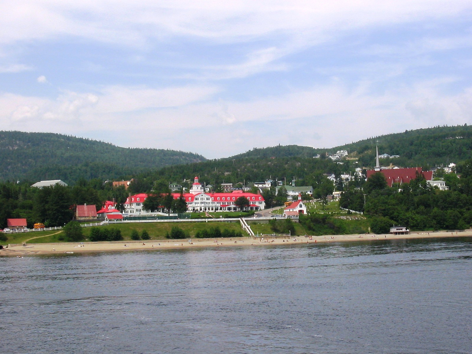
| | | | THE SAINT LAWRENCE Look at the map again to note that, to reach the Saint Lawrence, the road swings away from the fjord for some distance, joining the river road somewhat south, at Saint-Siméon. But what a spectacular arrival! At the intersection, there's a little park to pull into to enjoy the immense view across the huge Saint Lawrence. After getting used to the width of the Saguenay, being back on the Saint Lawrence was a whole new world. And then it was really quite a short distance up to Baie-Sainte-Catherine, back at the southern edge of the fjord. And that's another one of those names whose dedication is misleading. The town isn't named directly for Saint Catherine, but rather for a ship that sank here in 1686 named La Catherine. | | | | The provincial government provides an unusual service here. To complement the river road on the other side, the gap in the river road on this side caused by the fjord is filled in by a totally free, frequently running ferry, leaving every twenty minutes, which is as close to constant service as practicable. No sooner do you get in line at the ferry than the arrivals come off and you drive right on, for a 7-8 minute crossing of the fjord over to Tadoussac. This is an excellent panorama over the fjord (Photomontage by Bodokleksel) from the heights over Baie-Sainte-Catherine toward Tadoussac. Click to inspect, from the left, the view up the fjord, then the mouth of the Saguenay River with an approaching ferry and Tadoussac beyond, then the view out across the Saint Lawrence to the blue hills on its far shore 10 km (6 mi) away. Then, from on board the ferry (Photo by Taxiarchos228), there's a view up the fjord (Photo by Bouchecl) that's as good as any fjord cruise can offer. | | | | TADOUSSAC Tadoussac has everything going for it, history, charm, and a comfortable resort atmosphere. To me, even the name evokes what it's all about. This view looks down over Tadoussac (Photo by Bodokleksel) and its cove and marina, and then back across the fjord to Baie-Sainte-Catherine, where the approach road down to the ferry can be seen. | | | | European history in Québec doesn't get older than this. Jacques Cartier came to the site in 1535 during his second voyage, and found there natives hunting seal. Later in the 1500's, the site was visited by Basques, who were whaling in the river. In 1600, the first trading post was established here by Pierre de Chauvin, considered the founder of Tadoussac, primarily for the fur trade, making Tadoussac the oldest continuously inhabited European settlement in Québec, and the oldest surviving French settlement in the Americas. In 1603, Samuel de Champlain visited the site, which remained the only seaport on the river for 30 years. During the 1600's and 1700's it continued as the enter of the fur trade between the French and First Nations peoples. The Hudson's Bay Company purchased the trading post in 1831. | | | | In more recent times, Tadoussac's nature altered when tourism arrived and a Victorian hotel was built here in 1864 on the site of the trading post. It set the tone for the town, but was lost to fire in the early 1940's, so the present Hotel Tadoussac (Photo by Taxiarchos228) is a seven-decade old replacement, yet it retains the iconic red roof of the old one, distinctive even from a distance (Photo by Chris-13). I visited the lobby, which was a cozy place of calm and peace, with guests relaxing, and the roaring fire in the fireplace was welcome in the September coolness. The hotel is right on the water, on the Rue du Bord-de-l'Eau (Photo by Nowisaod), which I would translate as Edgewater Street, and which features a boardwalk and gazebo. Note the small red-roofed building in the background, to the right of the hotel. This is the old, historic Tadoussac Chapel (Photo by Taxiarchos228), built in 1747-1750, making it the oldest wooden church in North America. | | | | Turning left down the same street, one comes to the reconstructed Tadoussac trading post (Photo by TCY) on the hotel grounds, modeled after the original one from 1600. Even a short visit to Tadoussac is rewarding. | | | | NORTH SIDE OF THE FJORD The drive back along the north side of the fjord to Chicoutimi passes two stops worth noting. One is at Baie Sainte-Marguerite (Photo by J. Boulian) and the other is at Sainte-Rose-du-Nord. Near Chicoutimi as elsewhere there is autumnal forest, such as in this maple grove (Photo by J.P.Fortin). | | | | CHICOUTIMI The late September sun was getting low as I left the area of the fjord. In Saint-Fulgence there was now a long stretch of road right along the river as I arrived back in Chicoutimi (Map by ADQproductions), still on the north bank of the river, but approaching the bridge. As the map shows, this is not only the center of Chicoutimi, but the de facto center of all of the city of Saguenay. From the north shore, downtown Chicoutimi (Photo by J-P Fortin) shows its size, as this panorama indicates. While there are still river bluffs along the Saguenay River here, and while it's still rather wide, we are upstream from the fjord. At this point, we can drive back across to the south shore (nearby in the picture) on the Pont Dubuc (Photo by ADQproductions), the bridge that's the furthest downstream vehicular crossing. The next crossing downstream, to the right, is the Tadoussac ferry.
| | | | You will be tempted to say that's a lie, because directly beyond the modern concrete bridge you see a small truss bridge. This is the Pont Sainte-Anne, which used to be the main vehicular crossing. It's now cut off from roads on both sides and is just used as a pedestrian bridge, making the Pont Dubuc the last vehicular crossing before Tadoussac. | | | | I made a stop at the historic site of the Compagnie de Pulpe de Chicoutimi, an extremely important, leading pulp mill in the early 20C, since pulp production was a major industry here at the time. It was run by J-É-A Dubuc, after whom the bridge was named. As I then swung west back to Jonquière, the sun was just setting on the river. I drove beyond the gîte to the restaurant area for dinner, ending a satisfying day. | | | | Val-Jalbert I'd already ridden along Lac Saint-Jean on the train, with distant views across it. When planning, I first thought there wouldn't be much more to see other than more of the pleasant lake views (Photo by Johny-le-cowboy). And then, when making my advance plans, I found Val-Jalbert in Michelin, which made the trip worth it, so I added it to my schedule. | | | | My second and last full day in the area I went west toward Lac Saint-Jean (Map by Chicoutimi). I stopped at Alma to see how the Saguenay River looked this far upstream, but then continued on to Chambord, which has the rail station where my train coming north from Montréal had turned east to Jonquière. On the map, just beyond that little peninsula in the lake is the turn for the ghost town of Val-Jalbert. | | | | GHOST TOWNS & VAL-JALBERT Towns or villages can become abandoned because of numerous dramatic reasons, such as natural disasters, but a common reason for a town dying is that a railroad or highway bypassed it. My most vivid recollection of visiting a ghost town was in Alaska. On my visit to Skagway (2005/13), I drove nearby to the site of the town of Dyea to visit the remaining ruins. Both Skagway and Dyea were boomtowns during the Klondike Gold Rush when Klondikers had to hike from the docks in either town over White Pass into Canada, but then the White Pass and Yukon Railroad was built, which chose Skagway as its starting point, and, although Dyea in 1897-8 had a population of 5-8,000, by 1903 it's population was a half-dozen, and those soon dispersed and the forest took over the townsite. | | | | Also common cause for a town becoming a ghost town is an abrupt economic change. A mine or factory closes, for instance, and the nearby town is abandoned. That's what happened to Val-Jalbert, where the deciding factor was the closing of the pulp mill around which Val-Jalbert had been built as a planned factory town. One parallel is that Dyea's story took place in just a few years at the turn of the 20C, and Val-Jalbert's did, too, except that it lasted for less than the first three decades of the 20C. A major difference, though, is that Dyea is not maintained, or hardly so, while Val-Jalbert has been developed as a site for heritage tourism, and is maintained by the Québec government. Michelin gave it only one star ("interesting"), while I think it deserves two stars ("worth a detour"). | | | | It all started with the huge, fast-flowing and powerful Ouiatchouan waterfall, which a man named Damase Jalbert wanted to use to power a pulp mill he wanted to build next to it. Adjacent, he would build a company town. The entire venture flourished for only 26 years, and then it was all gone. | | | | It was in 1901 that Jalbert founded the Compagnie de Pulpe de Ouiatchouan and started building the pulp mill at the base of the Ouiatchouan Falls, which flows into the Rivière Saint-Georges. On that basis, the village he founded at the same time was named Saint-Georges-de-Ouiatchouan, the main street was and is still the Rue Saint-Georges, and the former convent school still has the sign above it that says École Saint-Georges. It was all ready to start functioning in 1902, but all went well only until 1903. | | | | The first troubles began in the years 1904-1909. Jalbert died in 1904, only three years into the project. There were some financial problems, and some Americans bought the company, with little improvement. Then in 1909 Dubuc of the important Compagnie de Pulpe de Chicoutimi (see above) bought the company, and things began looking up. In 1913, the new owners renamed the village Val-Jalbert in honor of its late founder, although the name Saint-Georges continued to appear for the street and school, and still does. | | | | | | The usual French word for "valley" is vallée; val appears somewhat more poetically, something like "vale". |
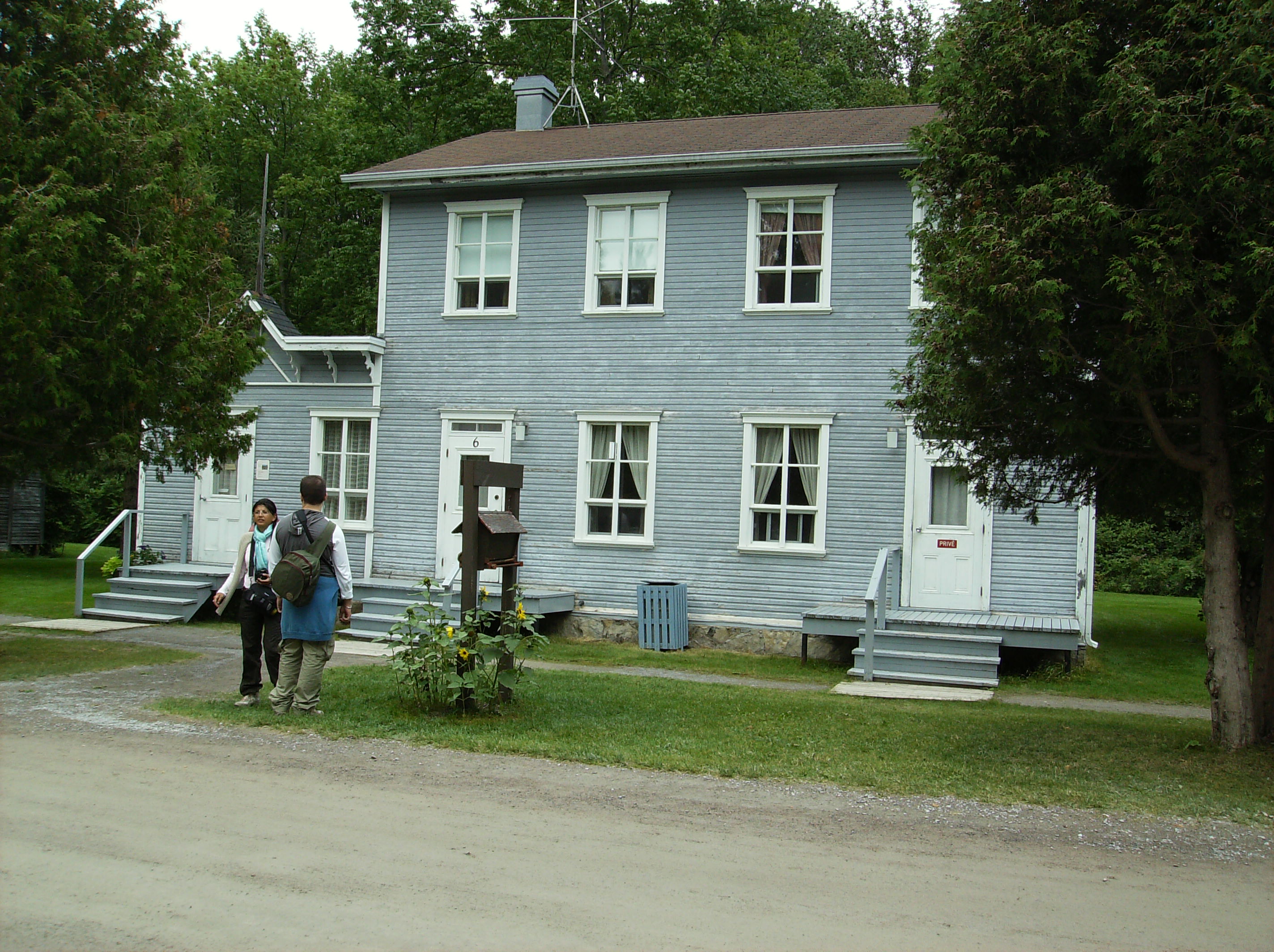
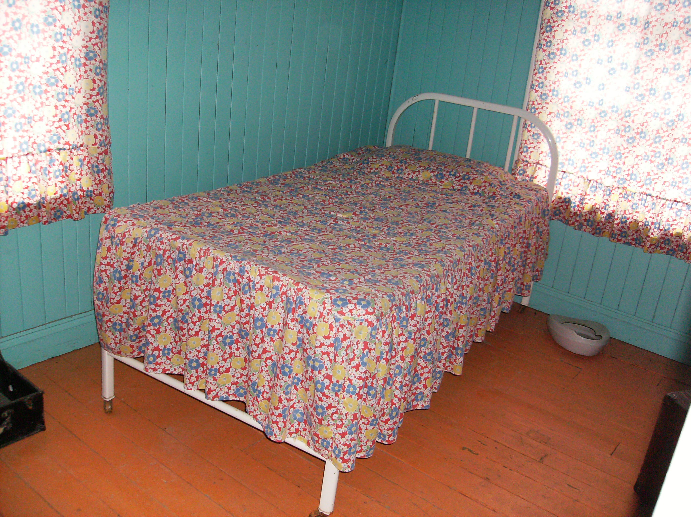
| | | | 1910 saw the height of production for the mill, and the years 1909 to 1922 are considered the golden age, when the company thrived and the village developed. There are notices on most houses with year of construction and names of residents, and the latter years of the golden age are prominent among those dates. By these latter years in the early 1920's Val-Jalbert was the envy of the surrounding communities because of the modern conveniences it provided, including electric power, telephones, water, and sewers. | | | | But even so, that golden age lasted only 13 years. Stiff competition developed into the 1920's and the years 1923 to 1927 were the years of collapse. Most workers were laid off after setbacks, and the market changed. These mills produced pulp only, and the market started to demand that companies produce both pulp and paper as well. Companies that couldn't do that became dinosaurs. In 1926, Quebec Pulp and Paper Mills Ltd bought the mill, but even they couldn't halt the decline. Production was suspended permanently the next year on 13 August 1927 and, in a few years, the one-industry town was abandoned. It's ironic that this collapse happened even before the world financial crisis of 1929 and the following Great Depression, although they did serve to make things worse. Finally, the Québec government expropriated the entire site in 1942 for unpaid taxes. | | | | In the following decades, former residents and their descendants—who remain active to this day--kept on hoping for the restoration of the ghost town of Val-Jalbert as a village, but it never happened. But the fact that the government owned it was in its favor. It did become a park in 1960, and by the 1970's Val-Jalbert entered into a second life. The Québec tourist office took charge and it was transformed into a Canadian cultural heritage site, on the Canadian Register of Historic Places. Legally, it's no longer independent, but part of the nearby town of Chambord. | | | | In 2009, more funding was appropriated for restoration, and as of 2010 some new changes took place, changes and restorations that I just took for granted when I was there, not realizing that they were only two years old. The visitor center was brand new; some houses on the main street were fully restored; the convent school was mostly restored; the general store was restored, and made into a gift shop and restaurant; the mill was restored, a restaurant was added inside, and the mill's missing roof was replaced; and partially up the falls, the glass viewpoint of the falls was new, with a glass floor that you could see down through. There is a gondola lift behind the mill up beyond the upper level of the falls, from which you can visit the so-called "Second Falls", the Maligne Falls. There had been over 80 residences and shops, of which over 70 remain, in various states of repair, and therefore Val-Jalbert has been described as the best-preserved ghost town in Canada. | | | | VISITING VAL-JALBERT The visit starts at the Pavillon d'Acceuil / Welcome Center, where a very good introductory film is shown in a petite, but new theater, with stadium seating. The characters in the film are all based on people traveling to Val-Jalbert over several years in a period railway coach. It shows Jalbert and his wife discussing the town with a cleric, who's planning the school and church; there's a worker in 1910 looking for a job; there's a reporter in various time periods inquiring about events. It ends on the last night the mill was open in 1927, with the flipping of a light switch and the end of a dream. | | | | When off the beaten path in Québec province, fully expect French to be the norm. Other than the counter people at the visitor center, everything was Francophone at Val-Jalbert, although provision was made for Anglophones. The film was in French, as was the entire (!!!) audience but me, as far as I could tell. I could follow some of what they said, but mostly I relied on the headphones I'd been provided at the desk for the corresponding dialog in English. Still, during my visit I greeted and commented to other visitors in French in a Francophone world. | | | | While small, the village is long and narrow. You can do a round-trip walk from the visitor center, but it's easier to take the shuttle to the far end, and then walk back, completely at your leisure, spending more or less time everywhere as you wish. While I think the shuttle (Photo by Abxbay) is a great idea, I wish they didn't make it look so faux-streetcar goofy, so typical for touristy places, which Val-Jalbert isn't. | | | | This online map of Val-Jalbert from their website is better and easier to follow than the stylized one, in either English or French, that one is handed on site. Rather than my repeating this link as we walk the village, let's do as we did in Reykjavik, and you might want to open a separate window and copy-and-paste the map link yourself: http://www.valjalbert.com/fr/planFlash However, the online map is only in French, so welcome to Québec. I'll be doing my own comments as we walk through town, but on the map, point to any number in a red circle to see its description, and, if you wish, click on the picture within to enlarge it (close it by clicking "FERMER"). The separate numbers in yellow circles, without pictures, are view levels at the falls. Once you're oriented, I suggest you click the plus sign several times to the maximum enlargement, to get you closer into town to follow our route. | | | | Mill, Falls, "Second Falls" The Welcome Center is at (1), and at (2) you pick up the shuttle (red dashed line), which also gives a preview of what's to be seen, and proceed up Rue Saint-Georges with its restorations. At this point, you already see the falls straight ahead of you, so the main street is beautifully situated. You then swing west on a large loop along the plateau to see other surviving houses as well as some ruins, and then end up at the mill and falls. | | | | At (14) is La Chute Ouiatchouan / Ouiatchouan Falls (Photo by Sylvainbrousseau), where it all began, with the mill next to it. Click to enlarge this closeup to "get your face into the spray". The speed and power of the water are amazing. The falls are 72 m (236 ft) high, which is 20 m (65 ft) higher than Niagara Falls. In the next picture, without the closeup, you can see by the wooden fence at the left that we're standing at yellow viewing location [1] on the map (Photo by Sylvainbrousseau), labeled (with a typo) Au pied [de] la chute / "At the foot of the falls". In this panorama we can see more of the restored mill on the left, but click to enlarge to spot on the hillside the large black inflow pipe that used to bring water from the top of the falls to run the turbines within the mill. Above the pipe is the télépherique / gondola lift (often confusingly called a cable car) that leaves from behind the mill. It has a nice view, and is preferable to the 764-step staircase, but doesn't have to go very high—the tower you see is already roughly mid-way. The wooden platform to the right of the tower leads to yellow viewing location [3], La tête de la chute / "The head of the falls", an optional stop on the gondola lift. I didn't get off at the top, because I found to be a preferable viewing spot the glass platform midway up the falls, which hadn't yet been built when this picture was taken. | | | | At (10) is Le Moulin / The Mill (Photo by Greymouser), now restored largely as a shell, including a museum area and restaurant. The inflow pipe is easier to see here. In the interior of the abandoned mill (Photo by LHOON), exhibits explain some of the remaining machinery (Photo by Greymouser). There is also a new model of the original mill, and one memorable room had a wall with period "workers' clothes" hanging on pegs, and lunchboxes waiting for the noon break. | | | | Behind the mill are the steps to the glass platform. If you haven't maximized the map completely yet, do so now. Compare the 764 steps to climb to the top of the hill (I took the gondola lift) to the mere 64 steps to reach viewing level [2] Au coeur de la chute / "At the heart of the falls", actually somewhat less than midway. Touch (11) Nouveau belvédère / "New lookout', and in this case, do maximize that picture to see what this marvelous platform really looks like. This picture I found of the platform (Photo by Sylvainbrousseau) shows somewhat less of it. | | | | But how can you visit a waterfall without seeing it in action? YouTube offered a couple of solutions. This short video is best at showing the rushing falls, and this other one is better at showing the platform, including the see-thru glass floor showing the trees below. | | | | The gondola lift was not included in the admission price, but I'd read in advance that AAA members get a free ticket, so off I went. Still, possibly because of the extra charge, there were few other people, and I was the only passenger either way, although I met a few visitors up top, to which a Bonjour! was in order. There's about a ten-minute walk on an up-and-down boardwalk with steps, to the far end, where viewpoint [5] says Vue sur la Chute Maligne, which is the name of the Second Falls. Touch (13), and click on that picture, since I don't have one. You can see that it's still a distance from the viewpoint to the falls, which are 49 m (160 ft) high. | | | | Actually, more interesting than the Second Falls was the stop at (12), misplaced on the map, as it's really right next to viewpoint [5]. It's the Le camp des bûcherons / Loggers' Camp. It's a reconstructed log cabin of the type that used to exist all over the nearby forests to accommodate the loggers sending logs down to the pulp mill. Touch (12), to see the log cabin, with a campsite in front of it. In the picture, an actor is portraying a logger; somehow one has a stereotype of French Canadians associated with burly loggers, so this is sort of a stereotype come true. This is a short YouTube video of the interior of the log cabin. | | | | Yellow viewpoint [4], labeled Vue sur le majestueux Lac-St-Jean (that's of course "majestic") is actually valid for anywhere on the front of the hill, including from the gondola (Photo by Sylvainbrousseau). Click to see the town of Chambord to the right, on the huge lake; the intermediate, optional stop on the gondola lift to the viewpoint at the top of the falls; the Saint-Georges river, with the lower wooden viewpoint (with stairs) in front of the mill; two of the restored management buildings (one remains missing) on the green in front of the mill; and the beginning of the Rue Saint-Georges going into town, with trees covering much of the street and houses. But when we get off the gondola lift, we'll instead turn right to walk a loop around the plateau area, before returning to Rue Saint-Georges and the center of town. | | | | The Plateau's Ruins & Survivors The residential back streets of the town, away from the center on Rue Saint-Georges, are up on a plateau. Look at the map again, to the green in front of the mill, where the two management buildings have that gray phantom building between them. Gray shows buildings that are now gone, most notably a cluster of former houses down by the river on the main street. Actually, since there are some 70 buildings remaining in Val-Jalbert, each house symbol on the map represents more than one actual house. The street pattern, though, is accurate. We should also point out that, while the main street has beautifully restored houses, up on the plateau, most of the buildings are stabilized, and some open to visit, but there are also a few outright ruins. | | | | As we turn off the green, you'll notice that the road goes uphill to the top of the plateau, and then turns left into the amazing Rue Labreque with its row of five or so totally collapsed ruins of houses. Approaching them is breathtaking, as you'll see when you touch (9) and click on the picture. I don't know why just this street has ruins, because they are nowhere else. I also don't know what plans there are, if any, for this street. That fire hydrant looks so forlorn. | | | | There are warning signs on these ruins (Photo by Peter Van den Bossche)—look at the missing roofs--not to enter them, but you can move close to look inside. It's so weird to look at a living room with no floor in it. Some houses were leaning alarmingly and grotesquely to one side, and this one is largely gone (Photo by Sylvainbrousseau). These ruins are such a contrast to the majority, which are well stabilized, and certainly, to the restored ones. | | | | Turning off this forlorn street one enters Rue Dubuc, named after the director from Chicoutimi. Here, and along the parallel Rue Tremblay leading into Rue Saint-Anne, which joins Dubuc and then leads into town, the houses are stable, although most are closed. You can read a notice next to the front door of who used to live in a given house, and go sit on a bench on the porch to "visit". Or just rest. | | | | What strikes one even from a distance about the rows of stabilized houses (Photo by Clifden) is their total lack of paint, worn away by weather over time. It then becomes obvious that you can't enter so many of them since shrubbery surrounds them entirely (Photo by Audreyannbrousseau), and the wooden walkways up to them are long since gone. Others though, still have rudimentary entries (Photo by Greymouser), and a few are museums. Touch on (6) and click on the picture, also (7) and (8). Some buildings have occasional furnishings, like a period bathtub. I particularly remember a display of ceramic electric plugs and outlets, so typical for the era, yet I'm more used to seeing displays for periods earlier than the early 1920's, which, by the way, is the period Val-Jalbert is set up to represent. | | | | There were two styles of house available for workers to buy. Most were single-family houses (Photo by Audreyannbrousseau) (note the white placard to the right of the door explaining who the residents had been), and a number were two-family houses (Photo by Sylvainbrousseau), in other words, two connected, semi-detached, one-family houses in one building. Note how perfectly symmetrical this building is, with a boarded-up door to the house on the left complementing the door on the right—which also has a placard of residents. | | | | Main Street We then turn the bend where Rue Saint-Anne descends to the main street, Rue Saint-Georges, and you can see on the map that we have entered a largely restored area. Of principal interest is the row of fully restored houses along one side of the street. Touch (17) for La visite de la maison de l'ouvrier / The Worker's House Visit, and click on the picture of this two-family building to see the restored wooden walkways leading up to the front door, some of which connect with restored wooden sidewalks leading down the street. | | | | Better still, compare this restored two-family house (Photo by Abxbay) (which seems to have some sort of an extension) with the above picture of the stabilized two-family on the plateau, and the comparison is astounding. Historic preservation (with restoration) is a wonderous thing. | | | | My notes remind me that I saw three houses that had at least some furniture, one of which was a two-family. Again, restorations are so often from an earlier period, and so often of houses of the wealthy, so I find it unusual to have seen a restoration of a 1920's worker's house. Kitchens might include an icebox (ice in the top compartment, food below); a period stove of one style or another; perhaps a period washing machine. There would be a contemporary living room, here with a period sewing machine. There might be a claw-footed bathtub. A bedroom might sport a chamber pot, or perhaps washstand, complete with ewer and washbowl (All interior photos by Abxbay). | | | | Attached to one of the houses was (16) Le bureau de poste / The Post Office, a tiny affair with a counter and post boxes. Across was Le magasin général / The General Store. Touch (15) and click on the picture to see that it's a large reconstruction that includes today a gift shop and a restaurant. Kept near it is an antique car, a green Dodge with 1928 Québec plates. Further down is a statue in front a building foundation. This had been the church, shown on the map as a gray phantom. It didn't deteriorate at all, quite the contrary. When the village was abandoned, the church was cannibalized for parts, the pews going to one church, the altar going elsewhere. | | | | But opposite the site of the church is the largest of the restored buildings (though unpainted), (4) Le couvent-école / The Convent School (Photo by Greymouser). Click to enlarge to see that it's still called École Saint-Georges. There are four classrooms downstairs, two on each side of a central hall. The hall includes a staircase leading upstairs to the nuns' quarters, including kitchen, chapel, work areas, all of which can be visited. Downstairs, the classrooms (Photo by Abxbay) are also restored, with period maps on the walls. | | | | On the town map, touch (5), Le sentier des écoliers / The Schoolkids' Trail. Although I didn't use it, it's apparently a combination of trail and steps. It was actually used by the kids living on the plateau to come down to school. | | | | I've found three short, very different YouTube videos of interest, each in its own way. | | | | | | A visual summary of what we've said is included in Les fantômes de Val-Jalbert / Val-Jalbert Ghosts. It's a good summary, and you'll be familiar with everything you see.
In Val-Jalbert en Évolution you'll see wintertime restoration work being done, evidently in 2010, including some nice before-and-after shots.
Finally, just held on 8 July 2012, less than than three months before I was there, was a Rassemblement des descendants / Reunion of Descendants of Val-Jalbert, illustrating that the village is, in a way, still alive. Starting at 2:53 you can see the green Dodge with 1928 plates, followed by some interesting views of the General Store.
|
| | | | Back to Montréal I returned the car mid-afternoon and the agent drove me back to the gîte, where I could spend the last half-day relaxing, which means, of course, writing. The next morning at breakfast, while diners had been at separate tables the first two days, we were all at a communal table on this, my last day. Fortunately, I could follow reasonably well what the gentleman opposite me, a teacher, had to say. Then, three people sat down to my left, and we managed, too. They were interested that I'd come to Saguenay en train from Montréal, moreso when I said I'd done so all the way from New York, and were wide-eyed when I said I'd next be visiting Ottawa and Québec (City) the same way. Since my wheeled bag and jacket were handy, I showed them my jacket, which had been given to me as a member by Eleanor Hardy of the Society of International Railway Travelers, whose logo was on the jacket. On the spur of the moment, I translated the name as the Société des Voyageurs Internationaux en Train, which seemed to go over quite well with my Francophone audience.
| | | | After breakfast, Madame's husband drove me and another gentleman to the station, where the trip back to Montréal was just as pleasant. This time, at Hervey-Jonction, I was pleased to feel the bump when the other half of the train, coming back from Senneterre, joined us in the rear. On arrival, I was ready to go for my second of three one-night stays between trains at the Delta Centre-Ville, in preparation to go to Ottawa in the morning, but I hadn't had dinner. | | | | Montreal Smoked Meat I've become familiar in the last two years with a few Canadian specialties, although they are all every-day type foods. I got to know the delicious butter tarts in Churchill (2011/28). Earlier that year, across the border from Québec in Vermont and Maine (2011/24), I had two other specialties. In Vermont, I twice tried the artery-clogging specialty of poutine, which is french fries and cheese curds. A few days before that, in Maine, I had a steak with Montreal steak seasoning, which I found out used the curing spices of Montreal smoked meat, which was developed in the 1920's, as a steak flavoring, a variation which was developed in the 1940's and 1950's. I found that the primary spices used in Montreal steak seasoning include garlic, coriander, black pepper, red pepper flakes, dill seed, and salt, although recipes vary. But I was determined to try what was the source of the steak seasoning, Montreal Smoked Meat. What I wrote on the 2011 posting was: | | | | | | It’s a type of deli meat similar to New York pastrami, and is made by curing and salting beef brisket with spices for a week, which is then smoked and steamed to completion and served on rye bread. |
| | | | It seems that Francophones call it viande fumée or also du smoked meat (!!!) I further read that, while smoked meat and pastrami are prepared similarly, smoked meat seasonings include more cracked peppercorns and aromatic spices, such as coriander, and significantly less sugar than New York pastrami. | | | | Although I found out that the most famous smoked meat restaurant remaining in Montréal is Schwartz's, established in 1928 by Reuben Schwartz, it was across town and not easily reachable for me in the time I had. However, Dunn's Famous is a smoked meat chain founded in 1927 by Myer Dunn, and one branch was located close to the far side of Central Station from my hotel, on Rue Metcalfe, and I went there, with my bag, right from the station. Rue Metcalfe turned out to be a traditional street with human-sized buildings, so different from the steel boxes of Rue University, and that added to the experience of having smoked meat at Dunn's. Still, both available online pictures below show sandwiches from Schwartz's. This is a simple smoked meat sandwich on rye, with mustard (Photo by chensiyuan), and this is what I had, the complete smoked meat dinner (Photo by Mixwell) which traditionally always includes, french fries, cole slaw, and a quarter pickle. Bon appétit! | | | |
| |
|
|
|


![viewing location [1]](http://upload.wikimedia.org/wikipedia/commons/5/57/Village_historique_de_Val-Jalbert_%281%29.JPG)