|
Reflections 2012
Series 4
May 1
Atlantic Ocean - Remote Ocean Islands - "Atlantic Isles" Trip
| | Atlantic Ocean Based on the upcoming trip this month, we’ve discussed oceans and seas in general, plus the Indian and Pacific Oceans in particular, pointing out that they are the second and third oceans Western Civilization (Europe) became aware of. That leaves the Atlantic Ocean, Europe’s first one, right on its doorstep. It’s also the area of the trip.
| | | | Let’s begin with a map of the Atlantic Ocean, which is the second largest, after the Pacific and before the Indian. You will note that this map, to cover all bases, shows an abrupt arc to allow for a possible Southern Ocean around Antarctica, and also for the Arctic (“Ocean”) Sea. You may see the Indian Ocean as perhaps being a pentagon, but in any case, not easily divided north and south. Perhaps the Pacific is a huge circle (the volcanism in the land around it is, after all, called the Circle of Fire); but only the equator artificially divides it into the North Pacific and South Pacific. Yet the Atlantic, despite the seas brimming out of it in all directions, does present the most distinctive shape of all, a clear S, and the wasp waist between Brazil and West Africa is an obvious dividing line between the North Atlantic and the South Atlantic.
| | | | THE GREEK TITANS & OLYMPIANS We also said that the Greeks and other early peoples in the Mediterranean at first had, as many historians agree, just one sea god, Oceanus, but as time passed on, they began to distinguish between the inward sea, the Mediterranean, as opposed to the great outward sea, the ocean. At this point Poseidon (Neptune) became god of the (smaller, inward) sea, leaving the (larger, outward) Ocean the realm of Oceanus. And the two bodies of water were separated then as now by the Strait of Gibraltar. This location is crucial to our understanding of the Atlantic.
| | | | The names of the Pacific and Indian Oceans are easily perceptible, but where did the Atlantic get its name? Was it a person? Sort of. Was it a place? That, too.
| | | | It all goes back to Greek mythology, about which I know very little, but a bit of research shows the basics, so now I know a bit more. We’re talking about Titans and Olympians, different sets of deities. It seems that they came in sets of twelve (see “duodecimal” in 2009/19 about telling time). | | | | The oldest set of Greek deities was the first generation of twelve Titans. They were the descendants of Gaia (Terra in Roman mythology), who was the personification of the Earth, and Uranus (Caelus), who personified the sky. Among the first generation of Titans was our friend Oceanus. | | | | The second generation of Titans consisted of the sons and daughters of the first, including Helios (sun), Selene (moon), Eos (dawn), Prometheus, and his brother Atlas. Prometheus was the champion of mankind who stole fire from Zeus and brought it to Earth, as depicted in one of the most recognizable statues in the US, the Art Deco one of Prometheus (1934) in Rockefeller Plaza in New York. We’ll get back to his brother Atlas, whose statue is also in Rockefeller Center, shortly. | | | | [Note that the Titans were a race of giants, hence our word “titanic” meaning “gigantic, colossal”. It also becomes clearer why the (for its time) large ship was named the Titanic, the centennial of whose sinking just passed in April. But just as the word “pacific” is hard to use today in its original meaning of “peaceful”, since everyone immediately associates it with the ocean, it is also difficult to use the word “titanic” today in its original meaning, since everyone would associate it with the ship instead. If you said something were a titanic nuisance and something else were a pacific gesture, people would misunderstand your point in both cases.]
| | | | But then the Titans were overthrown in a war of the gods by the Olympians, led by Zeus, and then there were twelve Olympians residing on Mount Olympus, as there had been twelve Titans in each earlier generation. The twelve Olympians tend to be more familiar names, especially in their Roman counterparts, so I’ll list them all: Zeus (Jupiter in Roman mythology), Hera (Juno), Poseidon (Neptune), Demeter (Ceres), Athena (Minerva), Apollo (also Apollo), Artemis (Diana), Ares (Mars), Aphrodite (Venus), Hephaestus (Vulcan), Hermes (Mercury), Hestia (Vesta). Later Hestia was replaced by Dionysus (Bacchus). | | | | ATLAS In the war where the Olympians overthrew the Titans, Atlas ended up on the losing side, and Zeus decided to punish him in an unusual way. Zeus condemned Atlas to stand at the western edge of Gaia (the Earth) and hold up Uranus (the Sky) on his shoulders, in order to keep them apart. Put more bluntly, Atlas became the chaperon in the bedroom whose duty was to prevent Gaia and Uranus from begetting any more little Titans. | | | | Although in a moment we’ll see a quirk, the logic here is basic. Atlas stood on the Earth (where else?) and held up the Sky away from the Earth. But what was the Greek concept of the sky? Celestial spheres. | | | | It was an early interpretation to explain what kept heavenly bodies up there. There was a glass (or perhaps crystal) dome over the Earth, actually part of a sphere surrounding the entire Earth, and embedded in it were the what you see in the sky. But that didn’t explain various movements of the stars and planets, so maybe there were several spheres, each one surrounding the previous one, each containing its own heavenly bodies, and which moved in different directions at different speeds. It was this set of celestial spheres that Atlas was condemned to support on his shoulders. | | | | I hope at this point the reader is objecting. What’s this about Atlas holding up the sky? Wasn’t he the one who held up the Earth? Well, yes--and no. Once again, it’s a matter of there being two answers, an objective one and a subjective one. The objective, factual one is that in Classical mythology, Atlas supported the sky. But over time, the everyday interpretation is that he holds up the Earth instead, illogical as it may seem, since where would he be standing (or kneeling)? It’s another of many instances of what I call a dual reality. You may know the facts, but “everybody knows” what is “common knowledge”, even though it isn’t factual, and this is an alternate, subjective reality.
| | | | But in this case, there is a reasonable explanation. This is a picture of the Farnese Atlas in Naples (Farnese was a 16C collector and patron of the arts). While some statues show a standing Atlas, most show him kneeling on one knee, as this does. The Farnese Atlas is a 2C Roman marble copy of a Greek statue, and is the oldest existing statue of Atlas. The globe he’s carrying shows a depiction of the night sky as seen from outside the outermost celestial sphere, with low reliefs depicting 41-42 of the 48 classical Greek constellations. The solidity of this marble globe in this very famous statue probably aided in the confusion that it was the Earth he was carrying and not the celestial spheres. | | | | There was a second thing that aided the confusion about Atlas carrying the Earth. In the 16C, it became common to bind together the many maps that were being published into a single volume. In the early 1570’s, the Italian Antonio Lafreri was a leading publisher, and he was the first who added an engraved title page to a book of maps with an image of the Titan Atlas on it, but it never went beyond the picture--he never referred to the work as an “atlas”. The innovation of calling the book of maps an atlas fell to the Flemish cartographer Geradus Mercator (of the Mercator projection world map), who dedicated what he called his atlas in honor of Atlas, King of Mauretania (modern-day Morocco and western Algeria), a learned philosopher, mathematician, and astronomer. As it turns out, there were two legendary Atlases, the Greek mythological character we’ve been discussing and also this learned (and equally mythical) Mauretanian, King Atlas. Mercator’s atlas actually pictured the learned king on its title page, and the book of maps was referred to as an atlas.
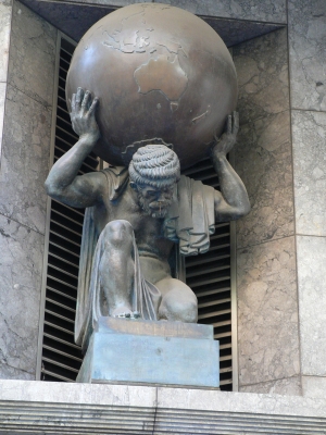
| | | | The final result is that (1) due to these two Atlas personages, books of maps are today called atlases, and the Farnese Atlas is still often pictured on them, and (2) “our” Greek Atlas, being now associated with terrestrial maps because of these “atlases”, added to the understanding that he was carrying a globe of the Earth. Nevertheless, this standing Atlas in Santiago de Compostela, Spain, is clearly carrying the heavens, since both sun and moon are visible. We just mentioned the Prometheus statue in Rockefeller Center, New York, and said his brother was nearby. Walking up out of Rockefeller Plaza and up Fifth Avenue about a block, opposite Saint Patrick’s Cathedral is the famous 1937 bronze Art Deco Atlas, again standing. The ensemble is as high as a four-story building and quite obviously does not depict the earth, but the celestial spheres. As a matter of fact, if you click to enlarge, you can see more clearly the symbols of heavenly bodies, such as, on the left, above his right hand, Neptune’s trident.
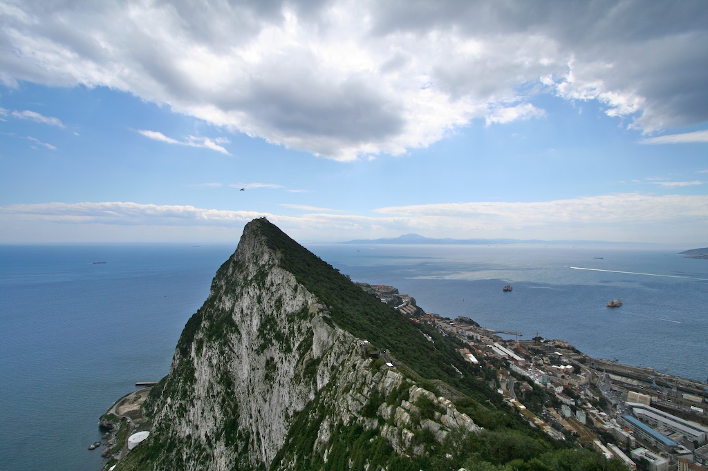
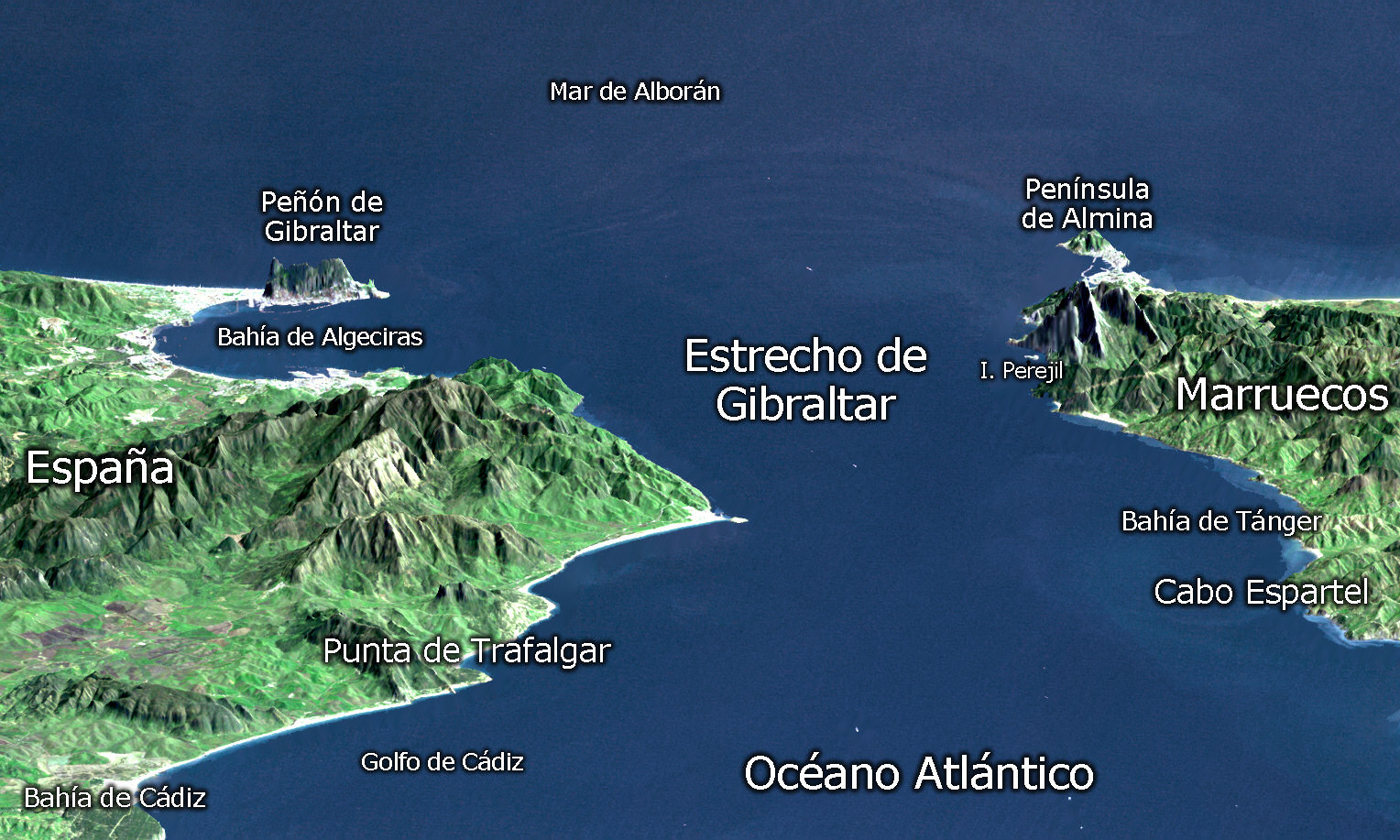
| | | | Yet the far more common conception of Atlas is that he holds a globe of the Earth, as in this Australian example. This Atlas, kneeling on one knee, another frequent depiction, is in Collins Street in Melbourne. Not only is he clearly carrying a globe of the Earth, but Australia is prominent in the lower front! | | | | THE ATLAS MOUNTAINS & STRAIT OF GIBRALTAR But the question has to arise about how Atlas got from Greece to the edge of the Atlantic, so be reminded that the mythology mentioned above has it that Zeus condemned Atlas to stand at the western edge of Gaia, the Earth, in order to hold up Uranus, the Sky, and the western edge of the known Earth means the western end of the Mediterranean. Since we’re dealing with mythology, it will remain unclear to what extent that refers to the Atlas Mountains (!!!) and/or the Strait of Gibraltar. | | | | The Atlas Mountains are a complex of mountain ranges running across the northwestern stretch of Africa for about 2500 km (1600 mi) through Morocco, Algeria, and Tunisia, separating the Mediterranean and Atlantic coastlines from the Sahara Desert. (This is also the area of ancient Mauretania with the learned, mythical King Atlas, so more mythologies than one intersect here.) Our mythical Atlas has been commonly identified since Classical antiquity with the region of the Atlas Mountains, abutting on the Strait of Gibraltar, so in the view of Greek mythology, the Atlas Mountains became important as a support of the heavens. The legends here are vague and overlapping, but two involve Greek heroes, Perseus and Heracles/Hercules. | | | | Perseus was the Greek hero who killed the Gorgon Medusa, who was one of three sisters who had hair of living, poisonous snakes, and a horrifying face that turned anyone who looked at it into stone. Apparently Perseus, who had cut off Medusa’s head, was wandering in the region, and Atlas tried to drive him away. Ovid tells that Perseus revealed Medusa’s head, and turned the Titan Atlas into stone, the very mountains that are today the Atlas Mountains. | | | | Another myth involves the Greek hero Heracles, who was later known in Rome as Hercules, the version of the name that is now more common. Hercules famously had to perform twelve labors, one of which brought him to the western Mediterranean, the westernmost extent of his travels. He was to fetch some golden apples from a garden tended by Atlas’s daughters, and he offered to hold up the heavens while Atlas went to get the apples for him. When Atlas got back though, he wanted to trick Hercules to carry the sky permanently by offering to deliver the apples personally. Hercules suspected a trick, so he accepted the offer, but asked that Atlas hold the sky again for a moment while Hercules adjusted his cloak as padding on his shoulders. When Atlas took the burden again, Hercules took the apples and ran away. | | | | In other versions of this story, Hercules instead built the two great Pillars of Hercules (see below) at Gibraltar to hold up the sky and liberate Atlas. And in another version still--these get better and better--Atlas was already a huge mountain, but was located right where the Strait of Gibraltar is. Hercules had to cross this mountain, but instead of climbing it, he used his superhuman strength to smash through it, thereby actually forming the Strait of Gibraltar to connect the Mediterranean to the Ocean. In cutting away the bulk of the mountain that was Atlas, the remnants on either side are what became the Pillars of Hercules. | | | | THE PILLARS OF HERCULES So, whether the story is that the Pillars are the northern and southern remnants of a mountain, or whether they were columns of stone purpose-built by Hercules to relieve Atlas and to ensure the safety of ships passing through the Strait, what are they actually? They really are mountains on either side of the Strait, one on the Spanish side and one on the Moroccan side. The one on the Spanish side is the world-famous one, the Rock of Gibraltar (actually located in the enclave of Gibraltar). The one on the other side has always been debated between two candidates. | | | | This is a high view of the Rock of Gibraltar, the northern “Pillar of Hercules”. It’s on a peninsula looking south across the Mediterranean to the African side. The town of Gibraltar is to the lower right, and a bit of Spain is visible to the extreme right. Visible across the water is one candidate for the southern “Pillar”, actually located, not in Morocco, but in the Spanish enclave of Ceuta. It’s called in Spanish Monte Hacho, which would translate to Beacon Hill. Ceuta is on an eastward-extending peninsula attached to Morocco, with the mountain visible here at the far end of the town. | | | | The other of the two likely candidates on the African side is physically actually in Morocco, and is called Jabal Musa, which is Moses Mountain, or Mount Moses. This view is once again from the Gibraltar side. But the identity of the southern “Pillar” has been disputed throughout history. | | | | [Note that the Arabic word for “mountain” (or, in names, “mount”), is “jabal” (or “jebel”), and you’ve actually seen it before, but in rather disguised form. The name “Gibraltar” is the Spanish version of Jabal Tar(iq), which would be Tariq Mountain or Mount Tariq. Tariq ibn-Ziyad was the Berber general who led the initial invasion of the Iberian peninsula in 711, in advance of the main Moorish force, to begin an occupation that lasted until 1492.] | | | | Let’s look at this (Spanish) map of the Strait of Gibraltar. The view looks EAST from the Atlantic inward toward the Mediterranean. Europe (Spain) and Africa (Morocco) are separated, at the Strait’s narrowest point, by 14.3 km (8.9 mi) of water. As I recall it, the catamaran ferry from near Gibraltar to Ceuta takes only 30-60 minutes one way. Note that Gibraltar is not the southernmost point on the European side, which is closer to us in this view. Opposite, the Almina Peninsula is where Ceuta is located, with Monte Hacho at the eastern end. Apparently Jabal Musa is the promontory above Isla Perejil (Parsley Island). | | | | Now let’s use this map to judge the Pillars of Hercules, particularly the southern one. The Rock of Gibraltar is 426 m (1398 ft). Monte Hacho in Ceuta is only about half its height, at 204 m (669 ft), but is directly opposite it, and also on a peninsula. On the other hand, Jabal Musa is 851 m (2792 ft), about twice the height of Gibraltar, but isn’t directly opposite. You can see why people have debated this for a very long time. | | | | But the Strait of Gibraltar, abutted by the Atlas Mountains, though the myths vary, is the “home” of Atlas. And the ocean waters beyond Gibraltar (behind us on the map) were then named after Atlas--but indirectly, via the Atlas Mountains. The oldest known mention of the “Atlantic” Ocean was by Herodotus around 450 BCE (=BC). It is reasonable to assume that at first, only the immediate waters west of the mountains were called the Atlantic, but then the name spread as explorers finally crossed the waters into the Unknown. | | | | PORTALS We can now summarize the three portals used by Western civilization to first enter the three oceans.
| | | | | | Because of the water routes of the Silk Road, the portal to the Indian Ocean was the Arabian peninsula, with one route coming down where the Suez Canal is today to continue on the Red Sea, and the other route emanating out of the Persian Gulf. This was later followed by the totally marine route around Africa.
We also saw that Balboa first spotted the Pacific on the south coast of Panama, so Panama was Western civilization’s portal to the Pacific, followed later by the totally marine route around South America.
But Western civilization’s “home” ocean was the Atlantic, and the portal through which Mediterranean civilization spread, from Classical times on, was the Strait of Gibraltar, abutted by the Atlas Mountains, which gave their name directly (and indirectly through the Titan Atlas) to the nearby waters to be spread across the sea.
|
| | | | “ATLAS” VERSUS “ATLANTIC” But something is wrong here. Are we saying it’s the Atlas Ocean? How do we get from “Atlas” to “Atlantic”? And wasn’t “Ocean” already a name, a reference to Oceanus? Are we saying that “Atlantic Ocean” is a double dedication? | | | | Last part first: yes, the reference to Atlas superceded the older reference to just Oceanus; this ocean is named after Atlas (via the Atlas Mountains) and now “ocean” is just a generic word and no longer a name. But how does that -NT- show up in “Atlantic”? If you were going to add -ic to Atlas to make it an adjective, wouldn’t you get *Atlasic? Or, maybe the S at the end isn’t part of the stem, so then it would be *Atlaic, right, perhaps pronounced at.LE.ik, with E as in CAFÉ? (Asterisks in linguistics identify forms that are non-existent or speculative.) | | | | Those are reasonable thoughts, and if it were so, most people would know right away where the Atlantic Ocean got its name. But it isn’t the case, and such situations are far from unique. And therein lies a tale. | | | | Take the Italian word for “man, mankind”: uomo (WO.mo). Italian words in -o usually take a plural in -i, so you’d expect the plural to be *uomi, but it isn’t. The stem uom- lengthens to uomin- before adding the -i, so the plural is uomini (WO.mi.ni), a form that looks a bit more like the related English word “human”.
| | | | Latinists will tell you that this happens in Italian because something similar had also happened in the ancestor of Italian, Latin, and that is true (nominative: hom/o; genitive: homin/is). But why did it happen in Latin, in the first place? How do we explain it, other than that it’s just so? I’ll explain it in two ways. Linguistically inclined readers look at the technical explanation, but most of us will pay attention to the lay explanation that follows it: | | | | | | In Geek-Speak: The morpheme (“word”) uom- has the allomorph (variant) uomin- in the environment (when it appears with) -i.
In plain English: Some words have short (uom-) and long (uomin-) forms, the long form appearing under certain circumstances, in this case, when plural.
|
| | | | [Side comment for deeper thinking: in such a case, which of the two forms is older? For the answer, rely on a simple rule of thumb: in language, words historically shorten; they do not lengthen. It’s like how mountains (non-volcanic ones) wear down, they don’t grow higher. The longer form in this and other words has to be older and reflect the original length of ALL forms. For instance, singulars are used more frequently than plurals, and in a handful of words, the singular form shortened, as in uomo--and its ancestor.] | | | | Another example can be taken from Russian. The word for “mother” is мать (mat’), which is surprisingly short. But other forms, including the genitive [singular] (“of the mother”) and the plural (“mothers”), appear as матери (materi), which show the longer version of the stem mater-. Once we see the additional -ER- here, it becomes more recognizable as in English “maternity”. It’s another example of a word having both a short and long form, depending on use. | | | | If you like this sort of thing, let me give you a few examples of English words derived from the LONG FORM of Latin words. Listed in order are (1) meaning in English; (2) the Latin nominative (subject) and genitive (possessive) forms; (3) the short and long stems of these; (4) English words derived from the long form: | | | | | | “body”: córpus, córporis; córp-, córpor-; not *corpation, but corpORation
“time”: témpus, témporis; témp- témpor-; not *tempary, but tempORary
“part”: pars, partis; par- part-; not *parition, but parTition
“cow”: bos, bovis; bo- bov-; not *boine, but boVine
|
| | | | Now let’s get down to the nitty-gritty. Atlas in Greek is Ατλας; if it’s easier to follow in capitals, it’s ΑΤΛΑΣ. That’s the nominative (subject) form. The genitive (possessive) form is Ατλαντος, or, in caps, ΑΤΛΑΝΤΟΣ. Even with the most minimal knowledge of the Greek alphabet, from the capital form you can see an -NT- appearing in Atlantos, the form that means “of Atlas”. Therefore, the short form of the stem of his name is Atla- and the long form is Atlant-. And there we have it. “AtlaNTic” is derived from the long form of his name. | | | | The long form is also involved in the adjective form in -ic. Remember what we said about the Arctic in 2011/26: Add to the root αρκτ- the suffix -ikos / -ικοσ which is the same as “-ic”, and you have arktikós / αρκτικοσ (ΑΡΚΤΙΚΟΣ). In the current case, add the long form of Atlas to -ikos to get Atlantikos (Ατλαντικος / ΑΤΛΑΝΤΙΚΟΣ). Thus “Atlantic Ocean” is Ατλαντικός Ωκεανός or Atlantikos Okeanos. | | | | Two final comments about this long form in -NT-: (1) the legendary island of Atlantis, first mentioned by Plato about 360 BCE, is also named after Atlas, using the long form. (2) In German, when speaking of a book of maps, the plural of Atlas varies. It’s either an every-day, regular plural, Atlasse, or a more erudite plural, Atlanten.
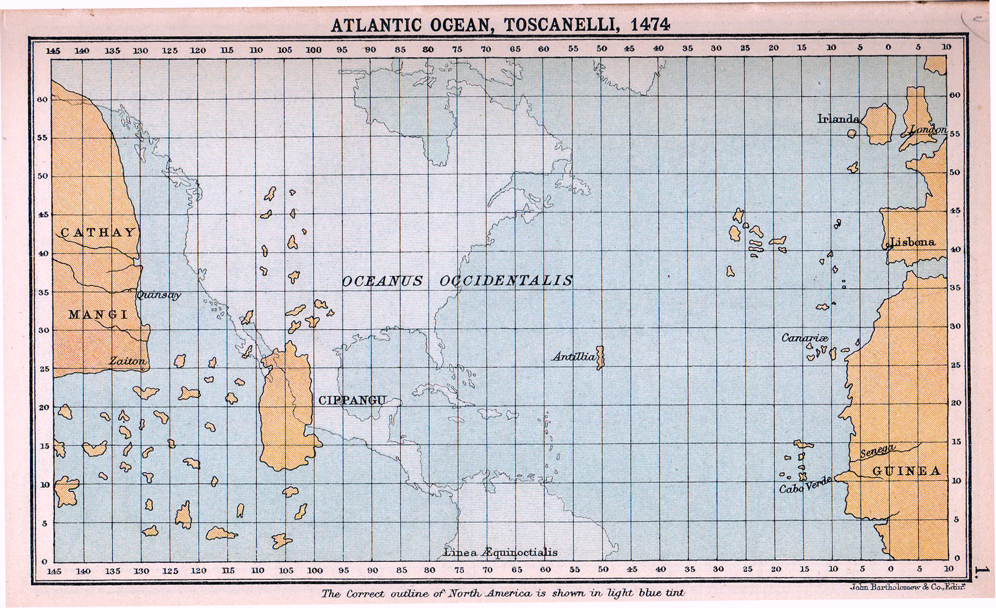
| | | | EXPANSION VIA THE PILLARS OF HERCULES Although the most ancient knowledge of the Atlantic was via the Gibraltar region, we are also aware that the Vikings in the north were early seafarers, not only to the British Isles, including the Shetlands, close to Norway, but to the Faroes, Iceland, Greenland, and to Newfoundland in the 9C-10C CE, traveling across the northernmost reaches of the Atlantic (2009/20). | | | | Yet when discussing European expansion across the Atlantic, we have to once again do battle with one of those pseudo-beliefs of the man on the street, foisted on him by popular culture. One we’ve discussed is the popular belief that Paul Revere actually shouted to the British subjects he was riding out to warn that “The British are Coming!” Another popular belief is the phrase “Columbus discovered America”, which almost every one on the street believes. Every one of the three words is only half true at best, although every one takes those words for gospel. | | | | Let’s start with “discovered”. No one “discovered” anything. It was all there already, as local natives already knew. It’s a matter of the extent to which knowledge of any new finds spread to Europe. I’ll continue to use the word, but in the implication that it was discovered FOR EUROPEANS. | | | | Then there’s the word “Columbus”. The Viking discoveries, including those by Leif Ericson starting in the 9C, led to modest settlements but did not in themselves cause any major change in history. What Columbus discovered in the 15C, and the settlements and other explorers that followed, including Balboa, did change history, hence the popular misconception. What we have here is an objective reality that Ericson made the first discovery, but with no follow-up, and the subjective reality that Columbus’s discovery, was all-important, since there was extensive following up. | | | | The last problem word in the phrase is “America”. Both Ericson and Columbus discovered islands. Ericson and the Vikings discovered the string of northern islands ending in Greenland and Newfoundland, and implanted northern European civilization in most of them (Newfoundland’s didn’t last). Columbus discovered the Caribbean islands, which he called the West Indies, and implanted southern European civilization there. He barely touched the mainland of South America and Central America (see below), and never made it to North America proper. While Spanish civilization was being implanted in the Caribbean islands, native civilizations were flourishing on the mainland, including major ones such as the Aztecs, Mayans, and Incas. | | | | The only “discovery of America” Columbus made that Ericson didn’t was that the American continents were a blockage to reaching Asia directly westward from Europe. Otherwise, both discoveries were just of a large number of islands. | | | | In the US it is ludicrous to celebrate a Columbus Day as a Discovery Day (and doubly ludicrous for Italian-Americans to consider it their ethnic day, based on the fact that Columbus was from Italy). Both the US and Canada should celebrate discovery by explorers that came in the third transatlantic flow along central routes, such as Hudson, Verrazano, Block, Gosnold, all discussed earlier re US history, and discussed re Canadian history, Champlain, Cabot, Cartier--even Ericson. | | | | Now let’s get back to transatlantic expansion via the Pillar of Hercules at Gibraltar, and in doing so, let’s give Columbus all the credit he does deserve--but not more than that. | | | | Picture carefully what he and cartographers of his time thought. The known land area was the massive Africo-Eurasia, and nothing else, on a round globe. Picture your right hand holding a grapefruit. Your hand represents Eurasia as it covers the globe, with your thumb is Europe and other fingers are Asia. The space between thumb and fingers is the shortcut from Europe to the Asian side of the double continent. | | | | The thinking was, if you could get to the (East) Indies eastbound via the Indian Ocean, maybe you could get there faster by going westbound. No other continents were known, so no one realized that the Americas were an impediment, and with that, no one foresaw the Pacific Ocean, either. This means that Columbus and the era’s cartographers must have thought that the Atlantic reached East Asia. Also note that he didn’t sail west, since that would have brought him to the upper part of East Asia. He went southwest on every one of his four voyages, looking for the (East) Indies. Remember that the “India” he was headed for was essentially what is Indonesia today. What a fabulous coincidence that the West Indies were located right where he was heading. | | | | Now that we’ve established a mental image of what he pictured, we can look at some maps to make it more concrete in our minds. Almost a couple of decades before Columbus first sailed in 1492, a cartographer named Toscanelli in 1474 published his notions of the geography of the Atlantic Ocean. The correct location of the Americas is superimposed on this map, for orientation. You can see that the estimate of the Atlantic’s width is reasonable. The Canaries are shown, Madeira would be northwest of it, and the Azores (here overly large) further northwest still. | | | | The mythical island of Antillia is shown; this is the source of the name Antilles, another name for the West Indies. On the east, China is represented by its traditional two names, Cathay in the north and Mangi in the south (2009/13). Japan is shown rather large and rather far south, and appears using Marco Polo’s name Cipangu (here spelled with PP). Pronounce it in Italian as Marco Polo did and you get chi.PAN.gu, the first two syllables being rather close to “Japan”. And hidden behind that are the (East) Indies. Noting the similar latitude of the East and West Indies, Columbus was doing well sailing in that southwestern direction.
| | | | An even closer influence datewise on Columbus’s plans was the globe fashioned in Nuremberg in 1492 by Martin Behaim, of which this is a detail of the Atlantic, as it reaches, of course, to Asia. Along with many inaccuracies and fictitious islands, Cathay, Mangi, Cipangu, and the Indies are there, as well as the Azores and Canaries. Most interesting is the additional mention of the Atlas Mountains. This globe corresponds particularly well with Columbus’s notion of the Earth, as he and Behaim drew their information from the same sources, so it’s reasonable to consider that this, or something very close to it, was the type of map guidance he had on his voyages. It’s compelling how the globe, and this chart based on it, make irresistible the notion of a jump across the little Ocean Sea to East Asia. | | | | This map shows what Columbus’s geographical conceptions might have been. It also shows how far east, that is, nearby, he felt Asia was. Note particularly India intra Gangem (today’s India) and India extra Gangem (today’s SE Asia and Indonesia). Cathay and Mangi are where the US is, and Cipangu is in the Atlantic. Note again the importance of the Azores, Madeira, and the Canaries to anyone venturing westward into the Atlantic. The French text explains that the dark black lines are the new concepts Europe had by 1500 of where the Americas were. Note the importance of Cuba and Hispaniola, Columbus’s home turf, as well as the North American coast and the bulge of Brazil. | | | | Finally, this is a map of the four voyages of Columbus during the dozen years starting in 1492. Note that none of his voyages actually went through Gibraltar, but actually started on the southwestern Atlantic coast of Spain, and always headed southwest. His usually stopped for provisions and repairs in Las Palmas in the Canaries, still commemorated there by the Casa de Colón (2007/8). He also got to stop at Madeira and at the southeasternmost island of the Azores, so these three island groups have to be considered stepping stones in his crossing of the Atlantic. | | | | On his first voyage (1492), they spotted what they named San Salvador Island on 12 October. It is uncertain which island in the Bahamas, or the Turks & Caicos, this island was. Nevertheless, Columbus was convinced the Bahamas were Japan, and Cuba was China. His second voyage (1493) led to the discovery of many smaller Caribbean islands. His third voyage (1498) explored Venezuela, including the Orinoco River. He described this as a new continent, but one that he felt was connected to China. His fourth voyage (1502) was actually meant to search for a passage to the Indian Ocean, and included investigating the coastlines of Honduras, Nicaragua, Costa Rica, and Panamá. Spanish culture did eventually spread from its toehold in the Caribbean, even to what became the southern and southwestern US, but Columbus discovered the Caribbean islands and adjacent coastlines. Further expansion came well after him. | | | | FLAG & COAT OF ARMS OF SPAIN Spain takes interesting symbolic note of the extent of transatlantic expansion of European history through the Strait of Gibraltar in its coat of arms, which is also included in its flag. The flag of Spain has three stripes, and the coat of arms is prominent, left-of-center, on the middle stripe. The coat-of-arms of Spain has two particularly interesting features. | | | | Supporting the royal shield and crown in the center, quite uniquely, are two columns, and these columns are each standing in water. These represent nothing less than the Pillars of Hercules at Spain’s southern tip. | | | | There is also an altered motto. The original Latin phrase, whose first known use was in 1637, that is connected by Renaissance tradition to the Pillars of Hercules, was the warning Ne plus ultra, the form most common in English, but which also appears as Nec plus ultra or Non plus ultra. Despite the varying negative words at the beginning, the warning can be translated by several similar phrases: “Nothing further beyond”; “[Go] no more beyond”; “[There is] no more beyond”; or colloquially, “This is it”. It was meant to serve as a warning to sailors and navigators considering leaving the Mediterranean to go no further than the Pillars of Hercules. | | | | [This original phrase is used in English as a noun, as in: “This car is the Ne plus ultra of automotive design”. Because it indicates there’s nothing beyond, it is used to mean the best, the acme, the peak, that there’s nothing better. It’s an interesting twist on the original use connected to the Pillars of Hercules.]
| | | | The heraldic emblem of the Holy Roman Emperor Charles V, grandson of Ferdinand and Isabella, and his personal motto as well, reversed this negative idea by simply dropping the negative word, and to this day, Spain’s coat of arms uses the phrase Plus ultra on the Pillars, which would be “Further beyond”, encouraging all to ignore the ancient warning, take risks, and go further beyond across the sea. It indicates the desire to see the Pillars as an entrance to the rest of the world--and to the expanding Spanish empire--rather than just a gate at the edge of the Mediterranean. Furthermore, Plus ultra is the national motto of Spain. | | | | PESO/DOLLAR SIGN People familiar with currencies using the dollar sign are sometimes surprised to find countries where that same sign is instead the peso sign. It also seems likely that they wonder why the peso countries “stole” the dollar sign, until they’re gently informed that it was the other way around. The dollar adopted the peso sign. Therefore, I’ll refer to it as the peso/dollar sign. | | | | The sign dates from the 1770’s, first referring to the Spanish-American peso, which was also known in British North America as the Spanish Dollar or “piece of eight”. It was the model from which later peso and dollar currencies were derived. The sign consists of two components; the letter S plus two (sometimes one) vertical lines. First, the theories for the symbol with one line. | | | | The best documented theory for the S is that it evolved out of the Spanish writing symbol “ps”, that is, a lower-case P with a superscript S, to represent “pesos”. A study of historic late 18C and early 19C manuscripts notes that people began to write the S superimposed over the P, perhaps with the lower curve of the S up above blending with the curve of the P down below, and eventually took its place entirely, the vertical line of the P becoming the single vertical stroke. If this is true, it’s amusing to think that what we’re looking at within the peso/dollar sign is essentially a “plural S”. | | | | There are other less-well documented theories, some of which are reasonable, others which seem more like urban legends, which is just what makes them fun. For instance, since the Spanish coins were called pieces of eight, one theory is that the sign started as a figure 8 with a slash (one line) through it. But this one is doubtful. | | | | Potosí, in Bolivia, was famous for its silver mining, and supplied most of the Spanish coins in the New World. The mint mark for Potosí coins consisted of the four letters PTSI superimposed over each other to make a single symbol, as shown on this silver coin. Look at the base of each Pillar of Hercules, at the four and eight o’clock positions to see this symbol. The theory would be that the S was the survivor, along with the common vertical stroke for the P, T, and I. Nice, but fanciful. | | | | The most enjoyable of the theories for the two-stroke dollar sign is that the two strokes represent the Pillars of Hercules themselves, as on the above Potosí coin. As for the S, it could derive from a depiction of the Plus ultra banner wrapped around both columns, as in this 16C depiction in Seville. Not too unreasonable.
| | | | There are a number of other theories, for both one- and two-stroke symbols, but one additional one for the two-stroke version is that it derives from a monogram of “US”, used on moneybags issued by the US Mint. A U superimposed on an S can look like a two-stroke dollar sign, with the curve of the U blending into the bottom curve of the S, leaving two vertical lines. This theory goes right out the window when it’s realized that the peso-dollar sign already existed before the formation of the US. | | | | I like the ps theory for the one-stroke, and the Pillars of Hercules for the two-stroke, but they can’t both be right, can they? Still it’s fun looking at something else that derived from the Portal onto the Atlantic at the Strait of Gibraltar. | | | | Remote Ocean Islands When we think of oceans, we think of remoteness, and particularly of remote ocean islands. Let’s find the most interesting ones. | | | | The Latin word for “island” is insula, which we can recognize in “peninsula”, which is pen+insula, or almost+island. We also see it in the adjective “insular” as in “insular living”. It appears in two English verbs. The verb that keeps the N is “insulate”, that is, make like an island, in a more protective sense. The verb that has lost the N is “isolate”, the one that implies the remoteness we’re talking about. | | | | We’re looking for mid-oceanic insular remoteness in a more romantic, travel sense. We don’t just want flyspecks or any other uninteresting islands with a palm tree and beach. At the other extreme, we certainly to cancel out the big islands. Anyone who says they’re “going to the islands” does not mean Britain, Japan, or New Zealand. We also should not consider easily-reached off-shore islands (Channel Islands, Catalina), or even clustered ones such as the Caribbean islands and the adjacent Bahamas, nor the Baltic or Mediterranean islands. Remote is remote, and far-off is far-off. | | | | An easy way to look at far-off islands is in the time-zone map we used previously, since it shows even the remotest of ocean islands in order to indicate what time zone they’re in. Click to enlarge the Indian Ocean. Discounting the larger islands, the Indian Ocean has perhaps the fewest islands of any interest. The better-known islands are the Seychelles and Mauritius, and perhaps the Maldives and Réunion. I understand they are popular stop-offs for cruise ships, but are not on my to-do list. | | | | The Pacific has the most islands of any ocean, grouped in Micronesia, Melanesia, and Polynesia. Move east to the Western Pacific. When I did my Pacific Islands trip in 2009, I chose Samoa/American Samoa, and Fiji here (2009/4 ff). Tonga has some interesting stories, but didn’t have enough to offer to attract me to make an additional stop. Move to the left of the map for the Eastern Pacific, where I chose to stop in French Polynesia for the Society Islands (Tahiti, Bora Bora, others) on the way back. In 2006 I had visited Easter Island (2006/14) on the way to Antarctica, and 2008 was my return to Hawaii (2008/22 ff). I would rank the Hawaiian Islands as the most enjoyable island stop in the Pacific, based on the variety of things to do, see, and enjoy, and I’d put Easter Island second, because of the incredible history of the heads. The only remote Pacific islands still on my to-do list are the Galapagos Islands, but note how far east they are, in the same time zone as Chicago and Dallas. | | | | But the upcoming trip is to be called “Atlantic Isles”, so let’s see what’s there. Start in the south. South Georgia and its wildlife (marvelous), and the Falklands, were part of the Antarctica trip in 2006. Further north, Saint Helena, the place of Napoleon’s exile, is, I understand, next to impossible to get to because of red tape. The Cape Verde Islands don’t have enough, in my opinion, to warrant such a complex trip (think of the many Pacific islands in a similar situation). Discounting the Caribbean and the Bahamas (Nassau is just a hop from Miami), Bermuda makes a marvelous trip. We had gone for a week years ago by air, and returned by ship (wonderful connections from New York) in 1999, as described in the Avant-Propos of this website. Bermuda signified our return to international travel after medically stressful years in the 1990’s, and it was a wonderful place for this turning point to happen. | | | | Right across from Bermuda are the Azores, Madeira, and Canaries. There is no name grouping them together, so, since the first two are integral parts of Portugal, and the third an integral part of Spain. I’ll call them the Iberian Islands. It might be nice to also consider them the Plus ultra islands because they were the first (or last) stops out of Gibraltar. | | | | The top of the map is grossly distorted due to the Mercator projection, particularly Greenland and Svalbard. Svalbard is the entire archipelago, which is better known by the westernmost island of Spitzbergen (2006/6). I had sailed on the Deutschland to Spitzbergen (marvelous trip) earlier in the same year I went to Antarctica, so in the same year I reached my two extremes on the surface of 80° N and 65°S. | | | | To the east of Greenland and Iceland are the Faroe Islands, and between them and Norway are the (here unnamed) Shetland Islands, part of Scotland. These islands, plus the Iberian Islands will constitute this year’s “Atlantic Isles” trip. | | | | The “Atlantic Isles” Trip As is so often the case, it started small. After checking the Amazon and Churchill off my to-do list in 2011, I was reminded from that list that list that I’d wanted to go to the Azores as well. Usually, I plan well ahead (the Churchill trip was largely booked before I went to the Amazon), but by early 2012, nothing was yet set for this year, so I started working on it. One concern was a dislike of backtracking, and I was glad when I found the Azorean airline SATA, which had direct connections from the US, without having to go all the way to Europe first. Visiting the three most interesting Azorean islands would maybe take a week or a bit more. | | | | But then I saw that SATA also flew to Madeira twice a week. When we went to Madeira in June of 1987, we did it as part of a Portugal trip, and had to fly to Lisbon, and backtrack that same day. But if SATA went directly, why not try Madeira again?
| | | | But aha! SATA also went from Madeira to the Canaries. We had gone to both Grand Canary and Tenerife in the Canaries during February vacation in 1985, and were very pleased that at that time, Iberia had direct flights to the Canaries from the US (no longer) so that there was at that time no backtracking via mainland Europe. We’d enjoyed that trip, so I added a stop in the Canaries this time, as well. So at this point, it would be direct flights to the three “Iberian Islands” in a row, then return hops back to the US, for a trip lasting about three weeks. I thought late May-early June sounded good. | | | | Then in January this year, still before anything was booked, a surprise came my way. I’ve always enjoyed sailing on the Deutschland, and had done so three times. Then the company had financial difficulties, sold its river cruise ships, closed its US office in Alexandria VA, and reinvented itself. I kept in touch with their website in German, but was waiting to see what happened. Then in January I was emailed an entire year’s itinerary, including the very trip they always did each year around the summer solstice, that I’d been longing for, to Greenland. It was too good to pass up. | | | | It’s not the first time I’ve done what seems to be two trips in one. For instance, when I went to the Pacific islands in 2009, the opportunity to sail on the Queen Victoria via Panama also came up, so I combined the two. So I added the Deutschland trip, which started in June, right after I was planning the Iberian Islands anyway, to that trip, for a total of six weeks. | | | | Actually there is very much an “Atlantic” advantage to this. While the (eastbound) Iberian Islands part by air relates to the explorers from the Gibraltar area, including Columbus, the (westbound) Greenland trip by ship is very much on the Viking route, including that of Leif Ericson. | | | | So as it turns out, after leaving in mid-May to the Azores, Madeira, and the Canaries, I have a connecting flight from Las Palmas to Hamburg. I’ll visit locally for a couple of days before taking the Deutschland out of Travemünde. We stop in Stavanger, a Norwegian city I have not visited, presumably to make it that much more of a Viking trip. We stop in the Shetland Islands of Scotland, the Faroe Islands, and then Iceland, where I haven’t been for a long time. We then proceed to the southwest coast of Greenland, for visits to fjords filled with glaciers, and a visit to the ice cap. The ship then returns to Iceland, where the trip ends. I’ll stay one more day there, then fly home at the end of June. Unlike the Galapagos Islands still waiting for me in the Pacific, after this trip I will have been to all the Atlantic islands I’m interested in.
| | | |
| |
|
|
|

