|
Reflections 2012
Series 2
April 2
International Date Line Redux
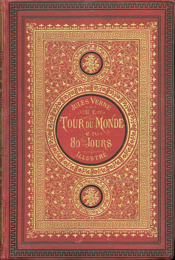
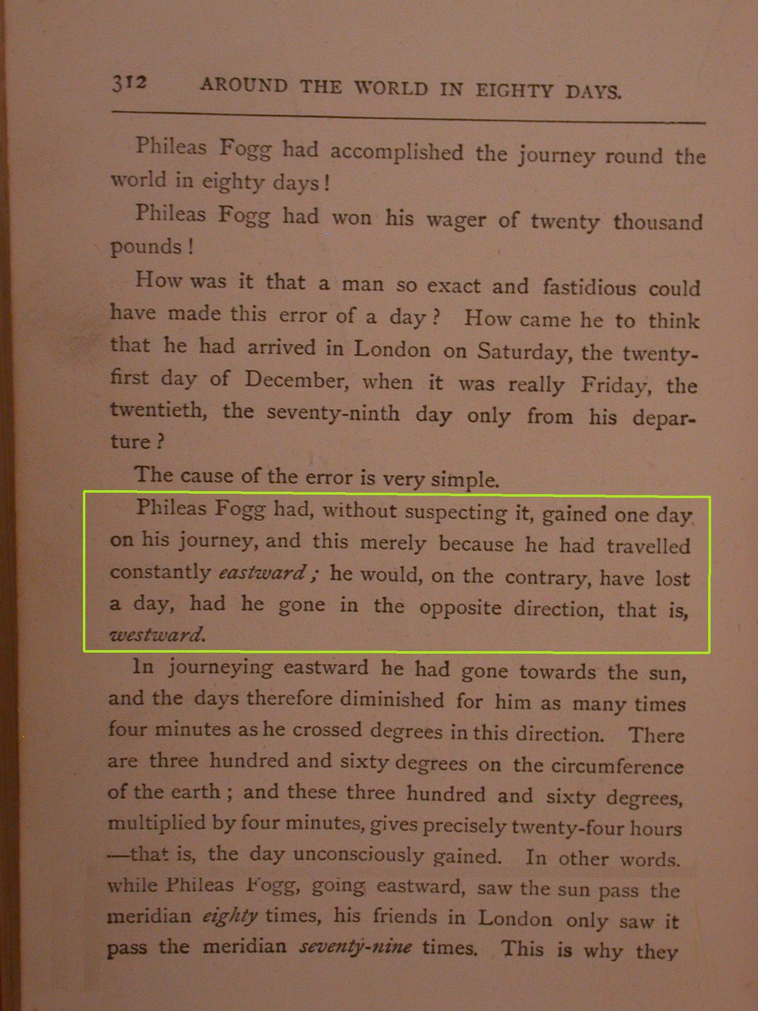
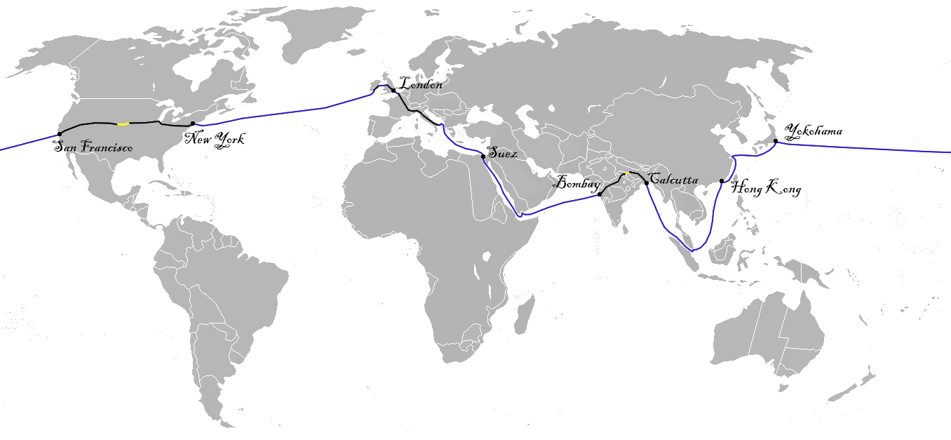
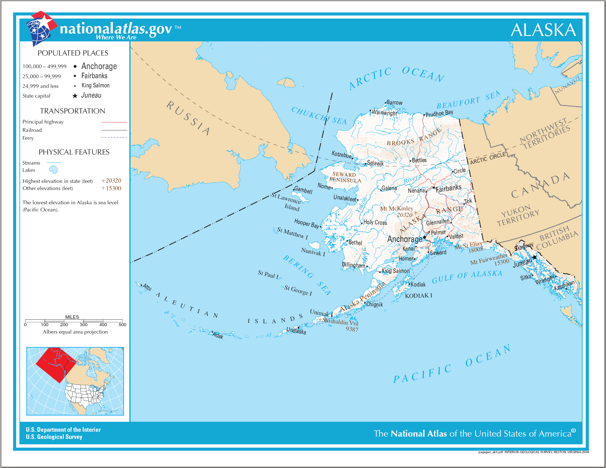
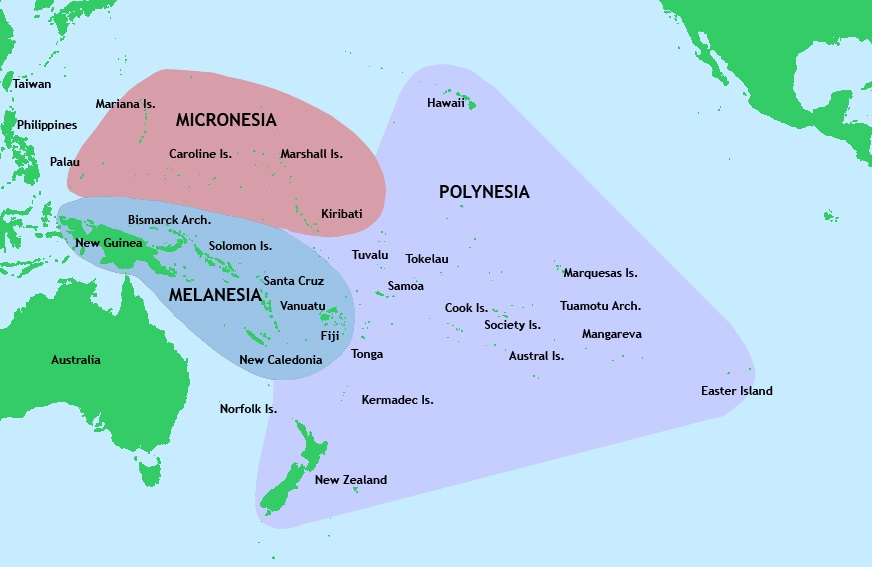
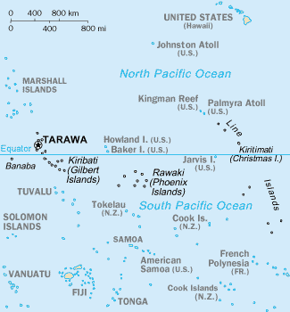
| | The prime travel topic for early 2012 is going to be Oceans, first in general, and then zeroing in on the Atlantic, including the North Atlantic as the principal conduit for the spread of European (Western) culture. We’ll then discuss remote islands, first in general, and then specifically Atlantic Islands, which will be the venue for travel in May and June. | | | | In planning the discussion of the Pacific within this framework, two things happened. In December there was an interesting development in Samoa regarding the International Date Line (IDL), so I wanted to go back into that topic a bit beyond what we discussed in 2009/7. Then in January, friend Joe P. wrote that he was about to set off on a five-week trans-Pacific voyage from San Francisco to Sydney, including 3 ½ weeks on the new Queen Elizabeth plus ten days in Sydney (from which he’s since returned). But I was flattered and pleased when he added: “I ran across one of your essays (I downloaded the link way back) on the international date line. I printed it out to read on the ship. I swear, I have a degree in math, and it still confuses me.” He says he now understands it. Well, when I don’t concentrate carefully, it confuses me, too, and I’m sure, others, so let’s have a new run-through, followed by some interesting additional information. | | | | Time Zones for Hours Let’s set that old basketball on a table in a dark room and shine a flashlight on it. The lit side is day, the dark side, night. | | | | [Aside: let’s note at this point the double meaning of “day” in most languages: day¹ is the daylight day, which can vary wildly, but for sake of argument, let’s say it’s 12h, while day² is the daylight day plus the night, or 24h. “What a beautiful day!” uses day¹, while “I’ve been here three days” uses day². I say “most” languages, because I can cite the situation in Swedish as being different, using two different words for the two concepts. Day¹, the daylight day, is “dag” (DAHG), while day², the 24h day, is “dygn”, a spelling which has the unusual pronunciation of DÜNG.n.] | | | | Back to the basketball. As you turn it to the left (eastward), the center of the lit side is noon, the center of the dark side, midnight; dawn is on the left, sunset on the right. Let’s use noon as a benchmark. It’s a constant, that is, the point below it is always noon, so actual noon moves from one town to the next in a constant fashion. | | | | This was fine for the millennia when transportation and communication were slow. It also explains why city halls and churches have traditionally had public clocks. When you rode in to town, you’d see what time it was there, which was probably different from nearby towns, since it was set from the noon sun overhead, probably using a sundial. | | | | Stagecoaches from town to town were slow enough that time differences of a few minutes didn’t matter. The railroads were the first transportation that moved quickly enough so that it did, in order to prepare precise schedules. Thus the artificial concept of the time zone was born. The first time zone was established on 1 December 1847 in Great Britain, and was at first referred to as Railroad Time. In 1868, New Zealand established what it called NZ Mean Time. | | | | The situation in the US in this period was confused. At first, each railroad established its own standard time, usually based on the city where its home office or its main hub was located. Railroad stations that were major junctions had a clock for each railroad’s standard time; Pittsburgh had six clocks. Finally, in 1883 the system was regularlized, and the time zone concept spread, but wasn’t formalized nationally by the US Congress until 1918. Yet, by about 1900, time zones had already spread around the globe. | | | | In a time zone, the actual solar time at the east end is lowered by about a half-hour, but raised at the west end, all around a central point, so it shows what can be called mean solar time. Therefore, abutting time zones have a one-hour difference. Given that we divide the day into 24 hours, there are 24 time zones, so let’s draw 24 vertical zebra stripes on our basketball, even though this is already somewhat inaccurate, since countries and states and provinces often redraw the time zone borders beyond a normal width, as seen in this map of countries and their time zones (“yr” means year-round, with no daylight time). The zones look most regular in North America and Australia, somewhat recognizable in Africa and South America, where they twist around countries, and most confusing in Eurasia, particularly the Asian part. Note how China (in yellow) maintains its huge bulk in one single time zone, which has to be disruptive to the people on the most extreme eastern and western ends; compare it to the several different zones in Russia to its north, and to South Asia to its south. Central Europe (in green) is also artificially overwide. | | | | IDL for Days While time zones measure hours, the IDL measures days, which is the source of confusion for many. If time zones, by averaging out where the sun really is, tell a low-level lie, the IDL tells a bigger one, but it just can’t help it. | | | | On our basketball, watch the zebra stripes go by, left to right, each one representing one of the 24 time zones. They form a constant. Every moment, there are 24 different hours around the globe. The trick is, how do you group them into a day? This is that higher level of artificiality, that larger lie. We know that 24 of them make up a day, but with the revolutions being continuous, where do we start and end? Where’s the seam? | | | | If the 24 zebra stripes represent the 24 hours, let’s take a length of ribbon just the circumference of the basketball, let’s say at its “equator”, and try to wrap it around the ball, the two ends coming together and just barely touching at a visible seam. This ribbon represents one day, with the first bit on the left being the beginning, the first hour, and the last bit on the right being the end, the last hour. Now where should we put the seam, the IDL? Which group of 24 hours on the continuously revolving ball do we want to call Day One? This is exactly the artificiality of it. We’ve got to choose one group of 24 hours, since Day Two will comprise the next revolution. | | | | Well, let’s try it mid-Pacific, which has two advantages. One is that it’s a low-population area so the change of one day to another would be less disruptive. The other is that it’s just halfway around from Greenwich, near London, at whose observatory the hour measurements are centered at 0° of longitude. And if we aim for 180° in the mid-Pacific, we have a convenient half-day, where midnight in one is noon in the other. | | | | With the seam of our ribbon (“Day One”) at 180°, it’s midnight on the IDL, which is a very special time. This is the ONLY TIME each day that it’s the same day around the entire earth, in this case Day One. We are now at midnight on the dark side of the basketball and the flashlight is shining toward us, beyond the ball, and on Greenwich, where it’s noon. | | | | We’ve got to mark our hours, so let’s remove the illustrative ribbon and put markers on each stripe showing the day and hour, reading D1-H1 to D1-H24. At midnight on the IDL, all zones are marked D1. The earth turns (we shift a bit to the right, too). On the other side it moves to 13:00 (1 PM) of D1 at Greenwich, and here at the dark IDL it moves to 1:00 (1 AM) but of D2! So we have to remark that hour as the beginning of the next day, D2-H1. Right now, very artificially speaking, there are two days on earth, one lone hour from D2 (“today”) just west of the IDL and 23 hours still marked D2 (“yesterday”). This continues until, let’s say, we have zones marked D2 halfway around, all the way to Greenwich, and our head facing the IDL on the basketball has also gradually shifted around with the ball so that now the flashlight is behind our head. It’s now midnight in Greenwich of D2 and noon on the IDL in front of us. Asia is in D2--today--but the Americas are still in D1--yesterday. We continue until we have one last D1 just east of the IDL, and an hour later, with the last shift, it’s D2 everywhere, and the cycle repeats. | | | | Let’s revisit the IDL at some random afternoon time, let’s say when it’s 15:00 (3 PM) right to the east. It will be 14:00 (2 PM) right to the west, of course, it’s just the next time zone, right? But wait. The IDL being the seam, that 14:00 is D2--the new today--while that 15:00 is the dying 15:00 of D1--yesterday. | | | | Those of us in the Americas don’t usually realize the simple facts, that we are always behind everyone else day-wise. We’re constantly at using up yesterday, while most of the Earth is already enjoying a new today. | | | | Travelers Now how does the IDL make travelers crazy? On the surface, it’s just another time zone, but you’re at the seam, and it’s a new today on the other side. Look at it this way. When I go westward from New York to San Francisco, that’s three time zones earlier, so when I get there, I have three extra hours of time on my hands. Look at it this way--at each time zone, my “time account” gets a debit note, an IOU, for each hour gained, for later payback. When I backtrack home, my account receives a credit (an hour) at each time zone, cancelling out the three IOUs, and I end up even. When I go eastward to London, at each of five time zones it goes the other way, I lose an hour each time, so my account is credited with five IOU’s. Returning, I get five credits (hours) back each time in my account, cancelling out the IOU’s one at a time, and I again end up even. | | | | When I’ve gone around the world, there’s no backtracking, but somehow that adjustment has to be made. Going westward, at each of the seven time zones from New York to the IDL, I gain seven hours, and my account gets seven debit notes for later payback. But passing the IDL, I go from my usual yesterday (being from North America) to the new today. Suddenly being a day ahead (gaining 24 hours with 24 credit notes), payback time starts immediately! Of the 24 hours gained, all 24 have to be debited!. Fortunately, seven of those debits cancel out the seven credits I already have in my account. Then, each of the remaining 17 debits from then on cancels the remaining 17 time zone credits coming to me, one at a time, that I get going back the other way around the earth. | | | | If you’re going eastward from New York, you lose an hour at each time zone, and pile up 17 IOU’s first. Then at the IDL by going from today back to yesterday, you gain a day (24 hours) and pile up 24 credits, 17 of which cancel out the 17 IOU’s you’ve accumulated up until that point, and you have 7 remaining credits to keep paying back each of the seven time zones all the way to New York. | | | | In other words “gaining” or “losing” a day at the IDL is all counterbalanced by one-hour debits or credits around the world equalizing the 24 hours gained or lost. Crossing the IDL but NOT going around the earth, as I did between New York (via California) to New Zealand and back in early 2009, is simply a condensed version of going round the world, with fewer time zones and hours involved. (NZ is only one time zone into the new day and New York to IDL is as above.) | | | | One last try at an explanation: picture yourself on a carousel, as a metaphor for the turning earth, and see how you can gain or lose a day. I’ll picture myself riding the historic Flying Horses Carousel last summer in Oak Bluffs, Martha’s Vineyard (2011/18). It runs counterclockwise, and let’s say a ride is about ten revolutions, so you get ten chances at the brass ring dispenser. On the second ride, let’s say you want until the attendant isn’t looking, dismount the wooden horse, and walk forward on the carousel one complete turn. While everyone else would have passed the brass ring dispenser ten times, I would have added one revolution by walking, and passed it eleven, the eleventh pass being when I was halfway around from my wooden horse. On the third ride, if I walk clockwise, past the back of my horse, for one revolution, while the others would have done ten, I’d have cancelled one out, and have done only nine turns. To further simplify things, clear away the horses and just picture a slow-moving turntable making just one single revolution. If I walk in the direction it’s going at the same speed, I’ll do two revolutions. If I walk opposite to the direction it’s going, at the same speed, I won’t move at all, and can easily stay next to the brass ring dispenser and empty it. | | | | Cultural References I’ve come across in Wikipedia two interesting cultural references, both literary, that fit very nicely into this discussion. I’ll elaborate on what I’ve found. | | | | JULES VERNE If we’re talking about world travel in general, and travel completely around the world in particular, who else is more appropriate to discuss but that consummate--and early--circumnavigator of the globe, (the fictitious) Phileas Fogg. He’s the famous protagonist in French author Jules Verne’s novel Le Tour du monde en quatre-vingts jours, known in English as “Around the World in Eighty Days”, one of Verne’s most acclaimed works. This is the first edition cover of 1873. | | | | It was the opening in 1869 of both the Suez Canal and the transcontinental railroad across the US that made a trip in as short a time as eighty days possible. The 1870 linking of all rail routes across India was also a factor. It’s therefore notable that, although Verne is usually characterized as a futurist (“From the Earth to the Moon”), there is absolutely no element of science fiction in this novel. | | | | The novel is possibly based on an American, George Francis Train (a travel name if I’ve ever heard one). In 1870, three years before the novel appeared, Train apparently did go around the world in 80 days. He repeated his feat three times afterward, his trip in 1892 actually taking only 60 days. Train wasn’t apparently too pleased by his feat being fictionalized. | | | | There is another interesting parallel, one that apparently happened too late to have influenced the novel, but which should be of historical interest to travelers. The year before publication, Thomas Cook organized the first tourist trip around the world, but it took seven months, starting 20 September 1872. | | | | In 1889, sixteen years after the novel appeared, the famous American journalist Nellie Bly (a pen name) undertook her most famous feat, duplicating Fogg’s trip for her newspaper, the New York World. She managed it in 72 days, and actually met with Verne in Amiens. Her book, Around the World in Seventy-Two Days, became a best seller. | | | | Verne’s plot revolves around a bet. Phileas Fogg is a wealthy member of the Reform Club in London, an 1836 upscale club that exists to this day, located on the south side of Pall Mall. The story both begins and ends here. Fogg makes a high-stakes bet with club members that he can travel around the world in (under) 80 days. The bet is substantial, half his wealth, or £ 20,000, worth over £ 1.3 million today. He leaves London by train at 8:45 PM on 2 October 1872, and has to be back by that same time 80 days later, on 21 December. After a long series of adventures and delays, he arrives back in London on what he believes to be the 80th day, fearing he has lost the bet and much of his fortune, but he’s then made to realize that he hadn’t accounted for the date line and it was actually only the 79th day, and he arrives back at the Reform Club just in time to win the bet. | | | | He had apparently traveled eastward, gaining a day, so the IDL is the basis for the dénouement, or final resolution, of the plot, as shown on this page of the English translation. This is an original French map of the trip (click to enlarge), where the Pacific is in the center. Here is another, perhaps clearer route map. As travel buffs, note in particular the new enabling routes, the passage at Suez, and the passages by rail across India and across the US. Geography buffs will also note the historic world borders, particularly in Europe (Austria-Hungary, German Empire), Africa, and Australia, where varying colonial lines hadn’t yet become state lines. | | | | We rarely do math here, but for Joe P. and other math majors--or math buffs--note this: the club members spent 80 days in London, which is our constant. If Fogg had gone WESTWARD, gaining hours, each of his days would have really been “long days” that were 1 1/80 (or 81/80) days long. Returning to London, he’d have spent on his trip 80 + 80/80 days, or 81 days. But he didn’t do that. He went EASTWARD, losing hours. Each of his days would have been “short days” that were really 1 - 1/80 (or 79/80) of a day long. Returning to London, he’d have spent on his trip 80 - 80/80 days, or 79 days. It’s all in the math. | | | | Ah, but wait. The math is true. The adding or subtracting of hours and days is all true. But unfortunately, the logic falters, so we have to burst the pretty balloon. Verne makes it into a nice story, but there’s no way Fogg wouldn’t have realized until he got back to London that he’d lost a day. After sailing across the Pacific, on landing in San Francisco and buying his transcontinental rail ticket, he would have already realized at that point that he’d crossed from “today territory” into “yesterday territory”. That is, unless he was befuddled by all that famous San Francisco . . . Fogg. (Sorry.) | | | | UMBERTO ECO I’m informed by Wikipedia that another work where the IDL comes into play is the third novel by the Italian author, Umberto Eco, who’s most famous novel is his first, Il nome della rosa (The Name of the Rose). Eco’s writing style includes subtle references to history, literature, and even to his other novels. His plots are intricate, vague, and abstract, and leave many questions unanswered, or, perhaps meant to answered by the reader. For instance, in “Rose”, he never explains the meaning of the title. | | | | Given this style, it’s understandable that the IDL became a useful tool and a central factor of his third novel in 1994, L’isola del giorno prima (The Island of the Day Before). The story is set in the 17C, and is about an Italian nobleman marooned on a becalmed ship in some sort of a harbor, but within sight of an island, which he believes to be on the other side of the IDL. Given Eco’s confusing style, another source describes the man as the only survivor of a shipwreck after a storm, and he’s washed up onto an abandoned ship in the harbor. He’s trapped by his inability to swim, and spends the entire novel reminiscing about his life and the adventures that brought him there, including increasingly confused speculation of the physical, metaphysical, and religious import of the IDL. | | | | Although I can’t imagine anything being much more different here from Fogg’s adventure, it is intriguing to see how the confusion of the IDL among travelers and others, and how it symbolizes a fusion of times, was appealing to Eco as subject matter. | | | | “International Date Line” I’ve been calling it the IDL because, as familiar as its formal name is, it’s so very inaccurate. Although it was created in 1884 by an international convention, there really very little “international” remaining about it. Just as countries, and states and provinces within them, can move time zone borders at will, so can countries near the IDL move it around to suit what they feel to be their needs. The New York Times, in its below article about Samoa, quotes the Royal Observatory at Greenwich as issuing the statement that “There seems to be no legal reason why any country cannot declare itself to be in whatever time zone it likes”. Rather than international, it’s about as local as any time zone is, so the word is worth abandoning as part of the name. | | | | The word “date” here is foolish. I’ve NEVER heard anyone say that it’s February 3 west of the IDL, but still February 2 east of it. That of course can be true, but the line is virtually never used to differentiate dates. It would be inappropriate anyway, since dates are fractions of a month, or even of a year, and the IDL has nothing to do with months or years. The IDL differentiates DAYS, not dates. Either it’s the new today to its west, and still yesterday to its east, or you can name them, and say it’s Sunday to the west, but still Saturday to the east. It’s a DAY line, not a date line. | | | | Only “line” bears some accuracy, but it tends to mislead, perhaps implying a straight line, probably along the 180° meridian, halfway around the world from Greenwich, at the 0° meridian. Historically, it seems to have been an even more irregular line than it is today; today, it’s straight, but zigs and zags so much that it’s actually a series of straight lines, largely N-S, but some E-W, and some diagonal. In a stab at accuracy, I’m going to refer to the IDL from now on as the “IDL Day Line”. | | | | And surprise of surprises, it’s not located simply between a pair of time zones. It actually HOPS time zones, sometimes one, sometimes even two. For the moment, let’s take a look at how the IDL Day Line looks today, without comment. We’ll take another look at it at the end, with further discussion. Before we do that, we’ll look at two early oddities and two contemporary changes. | | | | The IDL Day Line in the 19C Would you imagine that the IDL Day Line ever ran through North America? How about it separating parts of Asia? It did both. And curiously, both were based on colonialism. | | | | ALASKA The Russian Empire, in it expansion, spread from Europe, across Asia, and then hopped the Bering Strait to Alaska. It then proceeded down the Alaskan panhandle, and was headed toward what is today California. The proof is Fort Ross in Northern California (2001/8), a magnificent location near the coast, now landmarked. While this Russian fort has what sounds like an English name, “Ross” is here short for “Rossiya” (Russia). Further evidence is Russian Hill in the middle of San Francisco, at the top of which Russian burials were found. If expansion had continued, Russian territory could have bordered on Spanish territory, Mexico, and the Pacific coast of North America might never have been accessible to either Canada or the US. | | | | But that didn’t happen. The expansion was too expensive, and Russia never did actually expand that far south, and in 1867, the Tsar decided to relinquish all the land east of the Bering Strait, which is Alaska as we know it today. However, expanding down from central Alaska proper, the Alaskan panhandle still blocks from the sea what is today the Yukon and northern British Columbia, and clearly indicates to this day the direction in which settlement had been moving. | | | | But there’s something that doesn’t usually come up in histories of Alaska. Asia is on the “new today” side of the IDL Day Line, and until 1867, so was Alaska, being an extension of Russia. As a matter of fact, until 1867, Alaska began Russia’s day, since the IDL Day Line separated Alaska from British North America, which was to become Canada. Look at this modern map of Alaska and picture the line, not in the water to the west, but dividing North America by separating Alaska from the rest of it. There’s only one hour’s difference to this day between the bulk of Alaska and western Canada and the US, just there was then. If it’s 8:00 in Juneau, it’s 9:00 in Whitehorse, Vancouver, and San Francisco. But before 1867, it would have been, for instance, Sunday’s 8:00 in Alaska, while it would have still been Saturday’s 9:00 to the east across the border. | | | | The IDL Day Line is moved, as we’ll see in all four examples here, by adding or subtracting a day, depending on the direction you want to move the line. Alaska needed to lose a day, meaning it had to go from today back to yesterday. This is done by doing today twice. Since Alaska was then just west of the IDL, the first hour of, say, Friday appeared in Alaska, followed gradually by the other 23 hours. Then, when that first hour of Friday finished crossing what was to become Canada, Alaska would do that first hour a second time, followed by the others, and end up with two Fridays that week. This had the affect of moving the IDL to the west of Alaska, where it is today. | | | | From the point of view of the US and the rest of the world, that’s exactly what happened. When the Americans arrived in Sitka for the transfer ceremony on Friday, 18 October 1867, as far as they were concerned, the previous day had been Thursday the 17th, and theoretically, Alaska was in the midst of its second Friday the 18th in a row. Clear? | | | | But Alaska was a special case, for cultural reasons. in this unique special case, there had to be a second layer of change. It’s all because of the Julian calendar. | | | | The Julian calendar was a calendar reform by Julius Caesar in 46 BCE (=BC), which took affect the following year, 45 BCE. However, because of built-in inaccuracies, the calendar gained about three days every four centuries when compared to the observed equinoxes and seasons. In 1583, Pope Gregory XIII initiated what we now know as the Gregorian calendar, which was slowly adopted by the governments of most countries. The Orthodox Church, however, loath to follow the lead of its Catholic rival, remained on the Julian calendar, which is why, to this day, Russian Christmas falls on 7 January, thirteen days after Western Christmas. | | | | International adoption by governments was piecemeal and not immediate. Britain and its Empire, including the nascent US, waited 169 years to adopt it, until 1752. At that time, the necessary correction was 11 days, so that Wednesday, 2 September 1752 was followed by Thursday, 14 September 1752. This is why George Washington’s birthday, reformulated today with the Gregorian date of 22 February 1732, had earlier been considered as the Julian date of 11 February 1731, showing the difference of 11 days. | | | | [Aha! You noticed it, too! The difference seems to be a YEAR and 11 days, right? I got curious, too, and then I saw the notation “Annunciation Style” next to the date of 1731. More research reveals that there were TWO different calendar reforms in Britain in 1752. Up until then, Britain--and other places--considered the new year to begin on Annunciation Day, March 25. Washington was born in February, so under that style, it was still the tail end of the previous year. But along with adopting the Gregorian calendar, Britain also adopted 1 January as the start of the new year. What had been January, February, and three weeks of March 1731, the end of that year, suddenly became reclassified as the first months of 1732. It’s particularly unusual that Washington got his birthday caught up in BOTH of those changes.] | | | | In Russia, the Gregorian calendar was adopted during the Revolution, so it’s been out of step with the Russian Orthodox Church ever since. Wednesday, 31 January 1918 was followed by Thursday, 14 February 1918, dropping thirteen days from the calendar. This explains why for years the “October Revolution” of 25 October 1917 was celebrated on 7 November. | | | | The last country of Orthodox tradition to switch over was Greece, where Wednesday 15 February 1923 was followed by Thursday, 1 March 1923, also a dropping of 13 days. | | | | So let’s finally get back to Alaska. In 1867, Russia was still on the Julian calendar, so when the US took over Alaska, two changes had to take place. One was the one-day shift to move the IDL, and the other was the switch from the Julian calendar. If in the 18C the difference had been 11 days, and by the 20C it had increased to 13 days, the difference in the 19C was 12 days. Subtracting 12, but then adding one for the IDL, was a net difference of 11, so what actually happened in Alaska was that Friday, 6 October 1867 was followed by ANOTHER Friday, 18 October 1867 to include both changes and to align Alaska with the rest of North America. | | | | PHILIPPINES The other historical IDL difference involves another colonial empire, Spain. From 1565 to 1898, the Philippines were a Spanish colony, and were ruled from Mexico City, or at least until Mexican independence in 1821, after which they were ruled directly from Madrid. (In 1898 they became an American possession until independence in 1946.) During this period of being associated with the Americas, there was direct commerce between Manila and Acapulco, and just as Alaska had been an extension of Russia, the Philippines were considered an extension of the Americas (and Spain). Therefore the Philippines and the Americas were also considered to have the same day. In contemporary terms, that would be “yesterday” status, with the change in day then falling between the Philippines and the mainland of Asia, where the “new today” began. | | | | But during the 1840’s trade with Asia increased, and the IDL Day Line was moved from west of the Philippines eastward into the Pacific. If Alaska had to subtract a day and had Friday twice in a row before moving on to Saturday, the Philippines had to add a day, and skipped a Tuesday by jumping from a Monday to a Wednesday. In the Philippines, Monday 30 December 1844 was followed directly by Wednesday, 1 January 1845. In other words, Tuesday, 31 December 1844 never happened in the Philippines. Since this was New Year’s Eve everywhere else, one has to assume they celebrated Monday as New Year’s Eve. Also, by dropping a day, while 1844 was a leap year everywhere else, in the Philippines it was a regular 365-day year. | | | | I’ve found a most interesting map. Part of what’s special is what it shows, but it’s also special for having a striking error on it. It comes from a German book, Meyers Konversations-Lexikon, published in 1888, and illustrates the IDL Day Line in the 19C. Can you find the major error? | | | | While you’re looking, first note that’s it’s quite common for German to call der Pazifik “still” as in “Stiller Ozean” and sometimes even “gross” (great) as in “Grosser Ozean” (old spelling: Ocean). But then, of course, pacific means still or peaceful, doesn’t it? | | | | The most striking thing is to see the line right next to Asia, where it’s already Monday, leaving the bulk of the Pacific on the yesterday side, Sunday. But where’s the error? The line never looked exactly like this. The map was published in 1888, and it correctly shows Alaska post-1867, with the line to its west, so the North Pacific part of the line is correct. But the Philippine change had taken place much earlier, in 1845, so, while the mid-Pacific part of the line once did look as striking as this, it had already been moved by the time the map was published. Put it this way: up until 1845, surprising as it sounds, Alaska was to the west of the line and the Philippines to the east. Between 1845 and 1867, the Philippines had changed, and they were BOTH to the west of the line. After 1867, Alaska had changed, too, and they were once again on opposite sides of the line, but now Alaska was to the east and the Philippines to the west, as they are to this day. The map error is that it shows them both on the east side of the line, something that never happened. | | | | The IDL Day Line in the 20C-21C Although the day line is ideally located at 180°, even in the 20C and 21C it keeps on shifting, as two contemporary examples will show. Belying that there’s anything international whatsoever about the IDL Day Line, I picture it like a strip of yellow police tape with a warning not to cross it. But then you see someone standing at the tape, lifting it over their head and behind them, et voilà!, without moving a step, they’re on the other side. It’s purely a local decision, and the international “police” don’t have much to say about it, if anything. | | | | SAMOA The genesis of this current posting on the IDL Day Line was an article in the New York Times last December just before New Year’s (30 December 2011) entitled “Samoa Sacrifices a Day for Its Future”. Although I hadn’t seen it coming, I knew immediately what it meant. | | | | When I was in Samoa three years ago (2009/4-5-6), I clearly remember a conversation with the lady I had arranged my day flight to American Samoa with. As she drove me to the airport, she expressed her concern about the fact that the Samoan government was talking about changing driving to the other side of the road. It was then on the right, and the government wanted it on the left, to accommodate visitors from (relatively) nearby Australia and New Zealand (Japan also drives on the left, and is a major car producer). Sure enough, according to BBC News, on 8 September 2009, the change took place at 6:00 in the morning, when sirens sounded to make the switch, making Samoa the first country since the 1970’s to change driving sides. To ease traffic, a two-day holiday was declared, as well as a three-day ban on alcohol sales. Government officials were placed at each major intersection to assure compliance and safety. | | | | Thus when I read about Samoa losing a day, I knew that the article would say Samoa had also moved itself from yesterday to the new today, essentially “picking up the yellow tape and swinging it over its head behind it” without moving a step. | | | | I could also put it in personal terms. I flew from Los Angeles to Apia, the capital of Samoa, a distance of 7768 km (4827 mi). The Australian friend I first met in Apia, Jon F. had come from Brisbane to Apia, a distance of 3953 km (2456 mi), which is just half the distance I had, and much closer when you add on travel from New York. It then becomes clearer that Samoa would want to attract more relatively nearby visitors like Jon than distant ones like me by making these accommodating changes. And I might add that Samoa already used Australian and New Zealand electrical plugs and outlets, which have two pins (slots) almost forming a V, often with a third, vertical grounding pin (slot) in between. | | | | But of course, it’s more than that. Australia and NZ have become Samoa’s biggest trading partners, and not only do travelers from there go to Samoa, there are expatriates living there as well. Being 21 hours behind made business difficult, since having weekends on different days meant only four days a week were shared workdays. In addition, this change will put Samoa only three hours ahead of eastern Australia instead of 21 hours behind it. On the other hand, it will put Samoa a full 22 hours ahead of California instead of only two hours behind it. | | | | The only thing that concerns me with these changes is that Samoa now has distanced itself even further from what is culturally its third island, but which constitutes American Samoa, with very different and more modern ways. Samoa and American Samoa are now further divided by having different days and driving on opposite sides of the road (plugs and outlets were different already). | | | | But further research shows that history is actually repeating itself, and in both cases, commerce is the reason. Until 1892, Samoa was already west of the line, at which point, American traders convinced them to have the same day as the US instead of that of Asia. The change was made by having two Mondays in a row, specifically Monday, 4 July 1892. It was not a coincidence that that is American Independence Day. | | | | Samoa stayed east of the line for over 119 years, until switching back in 2011. The change was made by skipping Friday, 30 December 2011 and going directly from Thursday to Saturday. I would suppose it was done this way so that New Year’s Eve would stay put on Saturday, 31 December 2011. | | | | KIRIBATI We first discussed the Republic of Kiribati in 2009/4, when we were discussing Polynesian cultures and languages and when I overflew it on the way from Los Angeles to Samoa. We’ll just restate here its background, and a peculiar spelling quirk in its Polynesian language, also called Kiribati, sometimes Kiribatese, or in old style, Gilbertese. | | | | For these used to be (mostly) the Gilbert Islands, named after the British Captain Thomas Gilbert, who had sighted the islands in 1788. The area had been inhabited by Micronesians for three millennia. Later invaders from Fiji introduced Melanesian cultural aspects, just as later invaders from Samoa and Tonga introduced Polynesian ones. I didn’t have this excellent map of the three cultural areas in our discussion of the Pacific in 2009, so we’ll show it now. Note again how Fiji is in Melanesia, as is the larger island of New Guinea; how Polynesia extends in a triangle from the larger islands of New Zealand to Easter Island and Hawaii, including the Society Islands (Tahiti, Bora Bora, others), Samoa, and Tonga; and finally how Kiribati is historically at the eastern end of Melanesia, although it has spread considerably eastward across Polynesia, which will be the whole point of the IDL Day Line discussion shortly. | | | | When the Gilbert Islands became independent in 1979, even though the native name was Tungaru, they chose for their country the more foreign name “Kiribati”, which is a local adaption of “Gilberts”, because the new country was expanded to include the Phoenix Islands to their east, and the Line Islands, including Christmas Island, FAR to their east, expanding the country into Polynesia. These three island groups can be seen on this map. Note that the area straddles the equator, and that Christmas Island is so far east as to be due south of Hawaii. The Gilberts themselves, which include the national capital of Tarawa, also have the bulk of the 100,000 population. The Phoenix Islands are almost uninhabited, and only three of the Line Islands are inhabited, with a total population of 8800, mostly on Christmas Island, which is the world’s largest atoll. In other words, in this huge country of 32 low-lying atolls and one actual island, about 90% of the population lives at the western end and 10% at the eastern end. | | | | [We should interrupt here with an aside about that language quirk. Gilbertese is like its relative, Hawaiian, in that it has very few consonants. But while Hawaiian doesn’t have an S, Gilbertese sort of has one. An S appears, of all things, as a variation of T, when the T is in front of an I. For that reason, Gilbertese does NOT us the letter S in its alphabet, but instead uses the combination spelling TI. This becomes very revealing when you pronounce names correctly. When you see “Kiritimati” on the map, and know what the two TI’s stand for, you now know to pronounce it Kirismas, and will recognize it as the Gilbertese variation of “Christmas”. It’s harder though, when you see the name of the country, Kiribati, but when you do pronounce it correctly as Kiribas, you just MIGHT, with difficulty, see it’s really the word “Gilberts” in Gilbertese.] | | | | Now let’s get to the point about the IDL Day Line. The Gilberts themselves had been to the west of the IDL, but the two other island groups were to the east, Kiritimati being well to the east. The new country now straddled the line, and as in the case of Samoa and Australia-NZ above, the work weeks overlapped. But it was more troublesome in Kiribati, since it was the same country, and when it was Monday in Kiritimati and the other Line Islands, it was still Sunday in the capital to the west, so the work week was reduced to four de facto days for businesses and government offices. | | | | This was resolved in 1995 when Kiribati reached over, picked up that “yellow police tape” of the line, and swung it WAY over its head eastward, not one, but two whole time zones. By doing this, Kiribati is now the easternmost country in the world. (!!!) But of course, how else can you define “eastness” other than with the IDL? Thus the Line Islands (not the whole country) are the first area to enter into a new year, and that was the case in 2000. Therefore, the Line Island that used to be called Caroline Island was renamed Millennium Island. We’ll inspect all this when we have another look at the IDL map shortly. | | | | [Another aside is appropriate here. Kiribati, consisting almost exclusively of atolls, which are notoriously low-lying, is one of the world’s most vulnerable nations to the effects of climate change and rising seas. As a precaution, in 2008, Kiribati officials asked Australia and New Zealand to accept Kiribati citizens as permanent refugees. In 2012, it also negotiated with Fiji to evacuate some or the entire population to areas of Fiji that the Kiribati government would buy. The area of Fiji proposed for resettlement is the second largest Fijian island of Vanua Levu, just north of the island I visited, Viti Levu, which includes the capital, Suva. The mass migration would include younger, skilled workers first, and then the rest of the population over a period of years. Kiribati is expected to be the first country in which all land territory disappears due to global climate change. In 2008, its president said the country had reached “the point of no return”, and that “to plan for the day when you no longer have a country is indeed painful, but I think we have to do that.”] | | | | Inspecting the IDL We should now take a second look at that map of the IDL (click to enlarge) to discuss what it looks like today. | | | | Start at the very bottom. With 24 hours in the day, and Greenwich at 0° considered the middle (noon), the 24 time zones are numbered up to +12 approaching the IDL from the west--where it’s the new today--and up to -12 approaching from the east. The full designation is no longer GMT (Greenwich Mean Time), but UTC as a compromise acronym between the English Coordinated Universal Time and French Temps universel coordonné, so the two extreme designations in complete form are UTC+12 and UTC-12. | | | | The map is shown with midnight on the IDL, so that it’s “today” (here, “Sunday”) everywhere on earth. Today’s 24th hour has emerged westward from the IDL, and today’s 1st hour is about to die. The IDL is here at 180°, but soon moves away from it to the east. You will note that, since it’s human nature to want to be at the beginning of a line (queue) of waiting people and not at the end, the “golden side” of the IDL is to the west, where the day begins. No one wants to be in the last time zone with the dying day, UTC-12, and in practice, no one is (see below). Thus, when the IDL is moved, it’s almost always eastward, to turn yesterday into today, and not vice versa. Alaska was the only exception to this. | | | | You will also see two funny oversized numbers, UTC+13, and even UTC+14 (but NEVER oversized negative numbers; if no one wants -12, there’d be no market for -13). This does not mean that there are two extra hours added to the day. Whenever we go on daylight time, we move ahead one hour, moving into the standard time of the next time zone east. Thus, when New York goes on DST, instead of UTC-5 it becomes UTC-4, to be moved back later in the year. Now note that NZ is already in that “golden spot” of UTC+12. So how does it go on daylight time (which it does in its summer, the northern winter). It has to move to UTC+13. What is that? It’s exactly the same as UTC-12, except that it’s the NEW DAY, which NZ is on already, rather than yesterday. | | | | Look next at the very top of the map, the second of the three places where the line is actually at 180°. But then it veers east, to keep Russia’s day uniform, and then veers west, to keep Alaska’s Aleutian Islands in the same day. This is the ONLY point where the IDL veers west, spreading yesterday outwards. Note that UTC-12 disappears again, and even -11 does. Most of Alaska artificially keeps itself on -9, meaning that, if you leave Alaska for Russia, you have a four-hour jump--plus the day. | | | | In the midsection, the IDL returns to 180°, but note that the despised -12 disappears at Midway, which wants to be -11. Then -12 returns, for its only appearance in the mid-zone. But there’s a surprise. There are only two islands in this area, Baker Island and Howland Island (misidentified as Howard on the map), and both are uninhabited! That means that there are absolutely no people on earth who live in the last time zone of UTC-12! Now look down to Tonga and Samoa’s new location. They’re UTC+13. That’s exactly the same time on the clock as on Baker and Howland! But while those two unpopulated islands are on that hour yesterday, Tonga and Samoa are on that same hour today! It’s a funny game, but people will be people. | | | | Let’s finally look at Kiribati. It makes the line move furthest eastward, almost to 150°W. The country’s huge size spans three time zones, starting with +12 in the west. But then what used to be negative time zones (yesterday) is now +13 and +14 of the new today. This gives a weird north-south dimension to the IDL, which we usually associate with east-west differences. In other words, if it’s 9 PM on the Line Islands, it’s also 9 PM in Hawaii to the north and Tahiti to the south. Simple enough, except that that’s 9 PM today in the Line Islands and 9 PM yesterday in Hawaii and Tahiti. | | | | This is a World Time Zone Map (click to enlarge) to play with. Play wherever you like, but note that this map splits the Pacific, so look at how on the left side of the map the IDL seems to bulge even more precipitously eastward. | | | |
| |
|
|
|

