|
Reflections 2011
Series 3
February 14
Early Trails, Sails, Rails of Greater New York: West Hudson
| | When you look at a map of a contemporary city, you see sprawl. Urban sprawl denotes our age, the result of ongoing growth. Modern city maps show a homogeneity, with little individuality of place. You don’t see farms separating towns, countryside separating cities. Most of us usually accept that situation and live with it, without fully understanding the Why behind it. It’s only when you step back into the past that you see what the original smaller units were, and how they were connected. We’ve reviewed to some extent some of the smaller units that today constitute Greater New York (by this definition, Manhattan, four Outer Boroughs, and suburbs). We now build on that by attempting to discover the original connections between these sundry locations, that is to say, the early trails, sails, and rails of Greater New York. In no way is this to be a compendium of all possibilities, just an indication of What Used to Be to help guide us to understand What Is. | | | | In 2007/12 “Routes West” we discussed western trails becoming highways, and later on, the development of rail routes often alongside them. We will now do that in an urban area, New York. First, lift away all the 20C fixed waterway crossings, which to some extent (by no means entirely) unite the land divisions. Certainly remove all freeways and other modern trappings. Some of the “trails” we’ll discuss started out, quite literally, as Indian trails, or Indian footpaths, which possibly had been animal trails earlier, but most of what we’ll discuss are colonial roads. These will point west on the West Hudson side, and, on the East Hudson side, they’ll point both up the Manhattan Prong and out onto Long Island (Brooklyn-Queens-Long Island). Sometimes, colonial roads were built on the Indian trails, and often, newer, paved roads followed the very same dirt colonial roads, such as when, in 1926 the Federal Highway numbering system was initiated (“US highways”), which most often followed older routes. But in the earlier periods we’re discussing, picture dirt, mud, and stagecoaches.
| | | | The most interesting long-distance roads that we’ll be discussing ran in the three directions just mentioned and, given all the waterways in the area, were not connected to each other. That is to say, not connected until you include the one and only unifying force here, the ferries. In this region, our “sails” will be exclusively ferries, which were the only way to cross the numerous waterways of New York harbor until fixed crossings were built. We’ll talk about well-known ones, such as the Paulus Hook Ferry, the Fulton Ferry, the South Ferry, and the Staten Island Ferry, and others. We’ll mention the decline in ferries by the mid-20C, to be followed by their huge resurgence in recent decades.
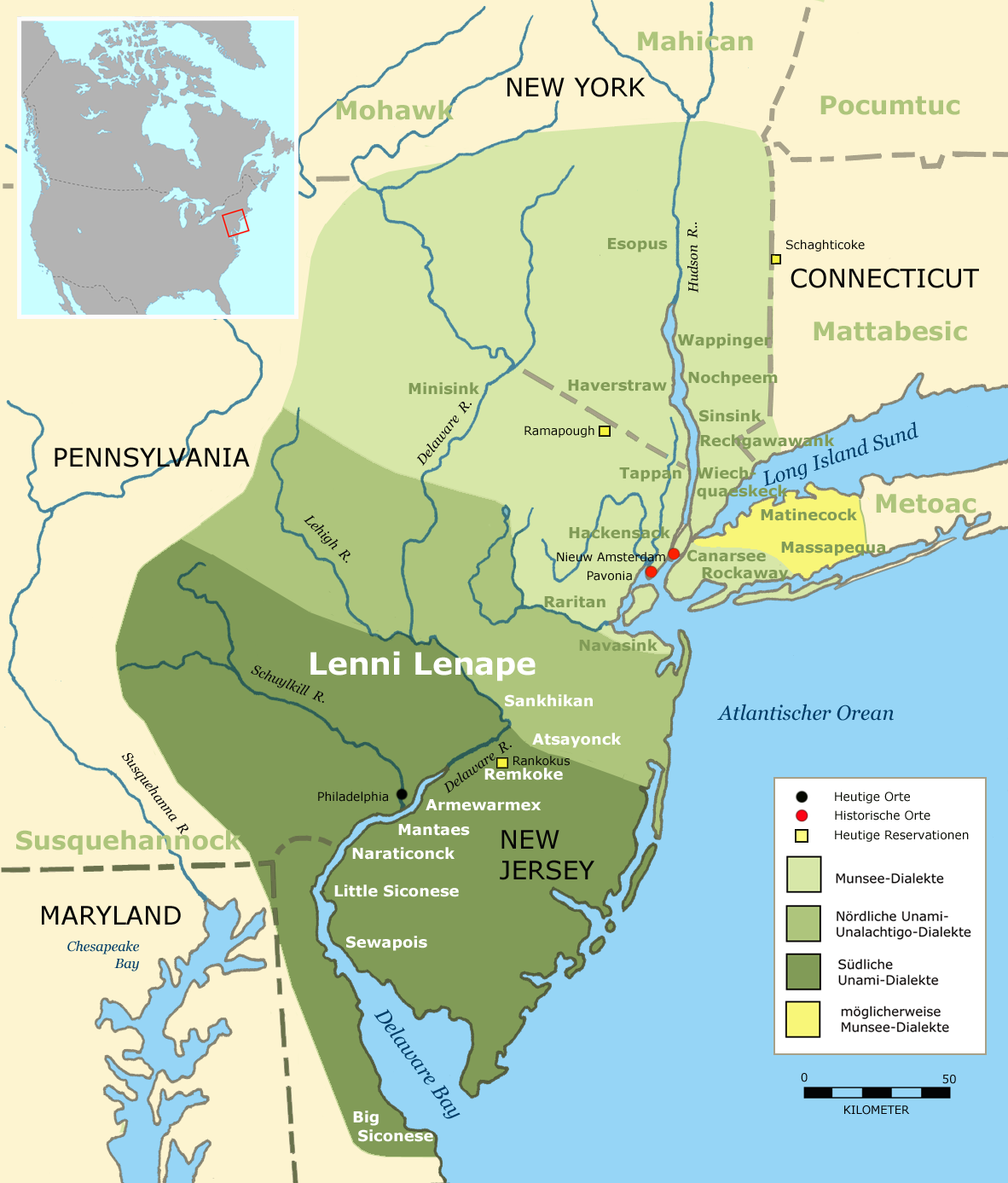
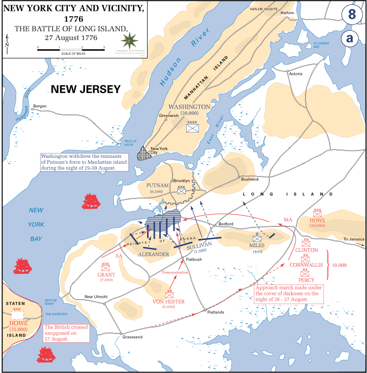
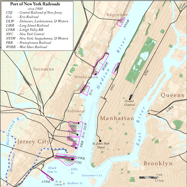
| | | | Finally, we’ll talk about “rails” and the peculiar situation of the Jersey side of the Hudson, which was as far as rails from the West came, just as Brooklyn was as far as Long Island rails came. Only New England and Hudson Valley rails actually entered New York (Manhattan). New York waterways definitively separated both rails and trails into three separate divisions--albeit connected by ferries. We’ll start by discussing the West Hudson area. | | | | Gateways I’ve read in two locations that the Indian trail that runs the length of Long Island started either in the Great Plains or in the Ohio Valley; perhaps one was the continuation of the other. I have no information as to where it crossed the Hudson, but an educated guess would be at Paulus Hook, and we’ll get to that shortly. The information I do have on the West Hudson deals instead with two colonial roads. | | | | YORK ROAD Keep in mind we are looking into examples of long-distance trails and colonial roads, not local ones. The first one of the two we’ll mention is the York Road that connected Philadelphia and New York. However, it started before Philadelphia and didn’t quite reach New York, or even the Hudson proper. | | | | It’s called the York Road (also the King’s Highway; today also the Old York Road) because it actually started in York, in central Pennsylvania near Harrisburg and Lancaster, then ran east into Philadelphia. It did not cross the Delaware River in Philadelphia, but upstream as it proceeded northeast towards New York. Today, visitors enjoy New Hope PA for its quaint charm, and Lambertville NJ across the river for its antiques. However, in 1732, one Emanuel Coryell set up a ferry between the two, and both towns bore the name Coryell’s Ferry. The York Road north from Philadelphia to the ferry was built between 1711 and 1771. The New Jersey segment east from Lambertville was built along a Lenape Indian trail, called the Naraticong Trail. However, the Jersey segment ended in Elizabethtown (today Elizabeth NJ; 1750 map from Rutgers University), which is located across from the NW corner of Staten Island at the north end of Arthur Kill, near Kill Van Kull, and Newark Bay. Elizabeth(town) was founded in 1664 and was the first capital of NJ. The Swift Sure Stage Coach Line made the trip from Philadelphia in two days, with an overnight stop near the ferry. | | | | Significant to me here is that this “road to New York” didn’t reach the centrally-located Hudson or Upper Bay, but only the back (achter) area of Arthur Kill. It’s claim to accessibility to New York was either a ferry (1736) to Staten Island, or a longer ride down Kill Van Kull into the Upper Bay and to New York (Manhattan) or Brooklyn. It seems like sort of a back door to New York. Looked at differently, it can be said that during the colonial era, Kill Van Kull played a significant role in travel between New York and the southern colonies. | | | | PAULUS HOOK But still, that route was not all that close to New York (Manhattan), while Bergen Neck, lying between the Hudson and Newark Bay, is. Today, the central part of Bergen Neck comprises Jersey City and Hoboken. Over the one-mile (1.6 km) width of the Hudson River, Jersey City faces Lower Manhattan (and my windows) from Battery Park up to about Houston Street at the south end of Greenwich Village. North of that is Hoboken, which faces Manhattan from Greenwich Village through Chelsea in the Teens and Twenties. They were the closest and most logical destinations for travelers crossing the river between New Jersey and Manhattan, since these areas were the populated area of Manhattan up until the 20C. And the most historic transportation hub there is Paulus Hook, which we’ve already referred to several times, including noting the ferry from Paulus Hook to Cortlandt Street on the Ratzer Map of 1776 (2011/2). | | | | In 1630, just six years after New Amsterdam was settled in 1624, Michael Pauw received a large land grant on Bergen Neck across the river. The name Pauw, which means “peacock” in Dutch (GE Pfau), was latinized (Latin: pavo; SP pavo; IT pavone) into the name Pavonia (“Peacockville”). Pavonia (the red dot should be further north, right opposite New Amsterdam) was the first European settlement on the west bank of the Hudson. Pauw’s holdings on Bergen Neck likely included 13 km (8 mi) of both Hudson and Hackensack River shoreline, and a ferry slip was set up toward the southern end of Pavonia at Paulus Hook, which was then an actual point of land, but which has now become obliterated due to landfill of the shoreline. The Paulus Hook neighborhood of Jersey City lies today on what had been the land of a Dutchman by the name of Paulez (or Powles, or Pauluson), a name anglicized to Paulus. The neighborhood today extends inland about 3-4 blocks from the Hudson with a shoreline about four blocks wide serving as a major transit hub, since it extends from the contemporary Paulus Hook ferry to the contemporary Exchange Place PATH tube station. Paulus Hook/Exchange Place has a trifecta of trail & rail & sail connections going back to the colonial era. | | | | An important highway from Paulus Hook west to Newark and points beyond had been established in 1795. Beginnings of this road, across Bergen Neck as far as the Hackensack River, are already visible on this map of the Battle of Long Island we saw earlier. There is also a tiny indication on this map of the point of land, now filled in, that Paulus Hook really was. In 1812, the world’s first steam ferry service was established by Robert Livingston and Robert Fulton connecting Paulus Hook to Cortlandt Street in Manhattan (remember the Ratzer map [2011/2]), with the ferry dock at the end of that colonial road, one of our first trail ‘n’ sail connections. In 1838, the ferry’s location influenced the location of the terminal of an early railroad running from there via Newark to New Brunswick, resulting in a trail-sail-rail trifecta, and in 1853, that railroad purchased the ferry operation. By 1871 that railroad had been acquired by the Pennsylvania Railroad, which built its own terminal. In 1909, the Hudson & Manhattan Railroad (“Hudson Tubes”) opened its tunnels from Paulus Hook to New York from its station at the Pennsylvania RR terminal, both by this time referred to as Exchange Place, named after a local square. This terminal with its ferry was the PRR’s main New York City (area) station until the construction of the midtown rail tunnels under the Hudson and Penn Station in New York itself. | | | | Once the tunnels directly to Penn Station in New York opened in 1910, service at Paulus Hook’s Exchange Place dwindled. The ferry service lasted until 1949, although PRR rail service lasted here until 1962, at which time the large terminal was demolished and the land redeveloped with office buildings, which are still served by the tubes, known as PATH since 1962. | | | | Four Railheads I consider Paulus Hook/Exchange Place New York’s historic gateway to and from New Jersey and beyond when you consider the colonial road, original historic ferries and historic rail connection. But we need to expand that image because of the multiple ferries today, and because of the multiple railheads that developed, specifically the role paid by ALL of historic Pavonia (that is, Jersey City and Hoboken) as railheads to and from the west, all connected to New York by numerous ferries across the Hudson. They are best seen in this fabulous map of Port of New York Railroads Circa 1900.
| | | | Note how many railroads reached the west bank of the Hudson, and note that none crossed over that significant barrier directly, with passengers always changing to ferries (and later on, to the Hudson tubes). Four rail-and-ferry stations are worth mentioning, and they all line up in prime position in Pavonia opposite Lower Manhattan, making all four locations visible from my windows. But given modern tunnels into Manhattan, rail service is different today then this map indicates. Note where it says DLW and think New Jersey Transit; where it says Erie and think shopping mall; where it says PRR and think Wall Street West; and where it says CNJ and think Museum.
| | | | (1) HOBOKEN TERMINAL I’ve recently reevaluated the rail hub situation in New York and now understand it myself far more clearly. I always considered just the two stations in Manhattan, and now realize that’s a shortsighted evaluation. Think in terms of 2-2-2: two central, two outlying (E-W), two intermediate (also E-W), and you’ll understand the rail hub situation far more clearly.
| | | | The two central stations are of course in Manhattan, Pennsylvania (Penn) Station and Grand Central Terminal. The two outlying ones lying east and west are Jamaica Station in the east (Queens) and Newark Penn Station in the west (NJ). Now consider the two intermediate stations: in the east, in Brooklyn, the newly rebuilt and renamed Atlantic Terminal on Atlantic Avenue (formerly referred to by the name of the intersecting street, Flatbush Avenue), and in the west, right on the Hudson, Hoboken Terminal.
| | | | On the map above, DLW indicates the former Delaware, Lackawanna and Western Railroad terminal in Hoboken, today restored as a major rail hub of New Jersey Transit. It is the ONLY rail station still in use as such on this Hudson shore, since all trains that used to service the other terminals (at least, the ones that still exist) now use the tunnel under the Hudson to Penn Station. Hoboken Terminal was built in 1907 in Beaux-Arts style, and the beautifully restored waiting room includes stained glass by Tiffany. Although using the name Hoboken, the site (actually, part of the rail shed in the back) actually straddles the Jersey City-Hoboken line.
| | | | (2) PAVONIA TERMINAL - NEWPORT CENTRE MALL On the map, the next location south labeled “Erie” refers to the historically named Pavonia Terminal of the Erie Railroad, built in the 1880’s. Due to the Erie-Lackawanna merger, the terminal was no longer needed and razed in 1961. The area is now part of the Newport development area and includes the Newport Centre Mall.
| | | | (3) EXCHANGE PLACE - WALL STREET WEST The third location south is the one we’ve already been discussing, Paulus Hook/Exchange Place. It was the location of the terminal of the mighty PRR, the Pennsylvania Railroad, which was the dominant railroad in this West Hudson area (the New York Central entering Manhattan from the north was it’s main rival). It was the railroad after which so many “Penn Stations” were named (NY Penn, Newark Penn, Baltimore Penn, others) and the architect of what I like to call the Great Connector, the tunneling under the Hudson to NY Penn, continuing under the East River to the LIRR, then north to New England. That the PRR had been located originally at Paulus Hook/Exchange Place is another reason to consider this location the principal Gateway from New York to and from New Jersey and points beyond. | | | | This is an aerial view of Paulus Hook/Exchange Place from above Manhattan (Photo by massmatt). My windows are just six and seven stories at this point, but this is essentially my one-mile (1.6 km) view across the Hudson, tho much lower. When we purchased our condominium in 1992 (with a tenant; we moved in ourselves in 1995), the two low brick apartment buildings on the extreme left absolutely towered over this entire Paulus Hook neighborhood. The relative petiteness of these structures heightened the sense of distance. The neighborhood had been derelict and mostly industrial, but is now part of NJ’s Gold Coast, the revitalized strip of land along the Hudson where economic development has spurred large-scale residential, commercial, and office development. We watched all the construction you see taking place, a total transformation that gave the impression of bringing the other side closer because of the large scale of the buildings. This area is today often referred to as Wall Street West, and it even has a ferry linking it around to the East River and Wall Street. This neighborhood has now overtaken Journal Square further west as the main business district of Jersey City. | | | | The tall building is the Goldman-Sachs Tower, built by the financial firm in 2004. Its 42 stories make it the tallest building in all of New Jersey. Its other claim to fame--now listen carefully--is that it’s the tallest building in the US that is NOT in its metropolitan area’s largest city. That being New York City, I suppose that can be rephrased this way: the Tower garners this additional distinction since it’s NOT in New York.
| | | | The GS Tower was designed by Cesar Pelli, who also designed the Petronas Towers in Kuala Lumpur (2010/16) and the World Financial Center that faces the GS Tower in Manhattan across the Hudson. It originally was meant to be the centerpiece of an entire Goldman Sachs campus, but many executives refused to make the move away from Wall Street, and the Tower’s top 13 floors remained vacant for its first four years. However, some 4,000 underlings had no choice and crossed the Hudson to settle in. However, the company also completed a tower directly opposite, on West Street in Manhattan next to the World Financial Center, and the company plans to shuttle workers between the two buildings on private ferries when necessary (although there are public ones and the PATH tubes). This they call their “Venice strategy”. Still, I find it heartening that this is another instance of ferry service (“sail”) actually being taken seriously here again, and at this historic crossing point at that.
| | | | If anyone wonders why so many people would balk at moving to the handsome GS Tower in Paulus Hook, which has gorgeous views of Manhattan, they can either look for a refresher course somewhere in New York Mindset 101, or let me gently refer them to “Professor” Saul Steinberg’s New Yorker cover (2011/1) again. It comes down to this:
| | | | | | Paulus Hook is Over There.
We are Over Here.
That’s the Hudson in between.
End of story.
|
| | | | (4) CRRNJ TERMINAL - MUSEUM The southernmost of the four terminals we’re discussing on the map, marked CNJ, was the Central Railroad of New Jersey (CRRNJ), commonly called the Jersey Central. It had its origins in the 1830’s and lasted independently until 1976. It built its present terminal in 1889, which operated until 1967. It is strikingly attractive in its Richardson Romanesque style and is on the National Register of Historic Places. (This view unfortunately has a white structure partially blocking it. From the height of my windows that is not the case, and the terminal presents itself across the river to the left as the GS Tower contrasts with it on the right.) The ferry slips in front of the building have been restored as has the building, which now serves as a museum for the local area and for railroading in general. Of particular distinction in this museum is how the former train boarding area is displayed. From the ferries, and through the waiting room, commuters would enter the Concourse, shown here today with café tables, separated from the abandoned trackage by a fence, with appropriate tablets. In the huge trainshed, the tracks are gone, replaced artfully with gravel and greenery. This is a Reproduction of a tablet for the Blue Comet, a train long since gone, including many of the rail destinations that no longer can be reached by rail. This museum gives as good an idea of historic routes emanating from a station as you’ll find.
| | | | Today, the terminal is part of Liberty State Park, which continues south along the shoreline behind Ellis Island and the Statue of Liberty. Striking is the view of the back of the Statue that presents itself (Photo by Derek Jensen), which you’ll find nowhere else. The location of the CRRNJ Terminal just behind Ellis Island recalls the era of massive immigration to the United States that took place here. It is estimated that around 10.5 million people entered the US through the station.
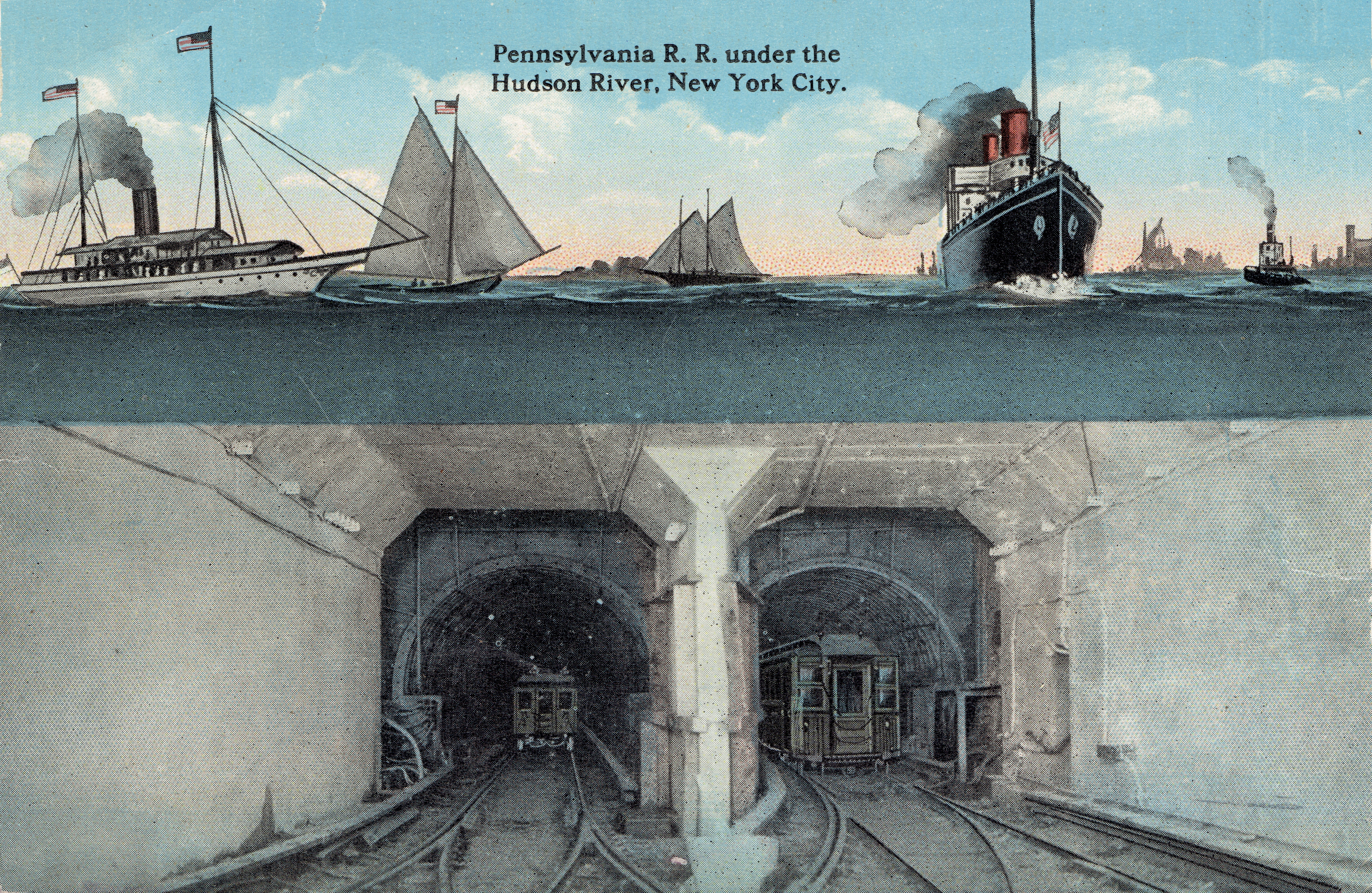
| | | | The H&M Hudson Tubes (PATH) As the 20C started, the railroads were in a race to get across the Hudson and into New York. And do not doubt that the railroads got across first, in the Aughties [first decade], while road tunnels waited until 1927 (Holland Tunnel) and 1937 (Lincoln Tunnel). Now while the most spectacular and meaningful rail tunnels were the Pennsylvania RR’s so-called New York Extension (below) of 1910, it wasn’t the first to successfully tunnel under the Hudson. That distinction went to what was then called the Hudson & Manhattan RR or H&M. (“Hudson” is not a reference to the river but to Hudson County NJ, which comprises most of Bergen Neck, including Jersey City and Hoboken.) Because of the tubular construction under water, they were also known as the Hudson Tubes. They were highly successful until the construction of the vehicular tunnels (see above), which drew away traffic (113 million riders in 1927, 26 million in 1958). Finally, in 1962, the Port Authority of New York and New Jersey (2010/27) took them over as part of the construction of its World Trade Center, built on the site of the Hudson Terminal, the H&M station on the West Side of the financial district. The railroad was renamed the Port Authority Trans-Hudson, and is always called PATH today. After Nine Eleven, its station under the WTC was destroyed, and stayed out of service for two years. PATH is not connected physically or via transfer with any other rail lines, not the NY subway, NJ Transit, or either of the NJ light rail lines. | | | | Let’s move in Pinteresque fashion from the present back to the turn of the 20C. We’ll first look at the PATH regular service today. It serves Hoboken Terminal, followed by Pavonia/Newport (Pavonia Terminal of the Erie RR originally; Newport shopping mall today), followed by Exchange Place (the original Pennsylvania RR terminal then; Wall Street West today). Later westward extensions after the original construction served the business center of Journal Square in Jersey City and Newark Penn Station. | | | | But it’s the “Trans-Hudson” part that’s of most interest, since that was the destination from the beginning, and PATH serves both Midtown and Downtown. The so-called uptown Tubes cross over to Greenwich Village and go up to 33rd Street and Sixth Avenue, which unfortunately is one long block east of Penn Station on Seventh Avenue, so trans-Hudson construction never did quite mesh here. That intersection where the PATH station is located also includes Herald Square, intersected by Broadway; Herald Square today is best known for Macy’s flagship department store. However, when the H&M was built, Times Square was little known (remember, it wasn’t even labeled on that early 20C map we saw), and Herald Square was the big theatrical entertainment center, so the location made more sense at the time as a final destination.
| | | | [Remember George M. Cohan’s 1904 song that famously said “Give my regards to Broadway, remember me to Herald Square”. It was Broadway crossing Herald Square he was talking about, which makes it quite ironic, and actually anachronistic, that his statue, which quotes that line, is today located where Broadway crosses Times Square instead. His slice of “Broadway” was actually not our slice of “Broadway”.]
| | | | But it’s the so-called downtown tubes, crossing from Exchange Place to what is today the site of the World Trade Center, that has to be considered the most historic Hudson crossing (even if they were built second), given the Gateway status of the Paulus Hook area and its ferries going back to the Ratzer map. | | | | Reviewing the PATH service map, it’s quite clever how all possible connections are serviced. But PATH runs 24/7, and, although I’ve ridden the entire route, my experience has always been with the late-night and weekend service, where the red route is maintained, the green route eliminated, and the other two combined. Coming from Hoboken I always have to change at Grove Street to get to the WTC station near me.
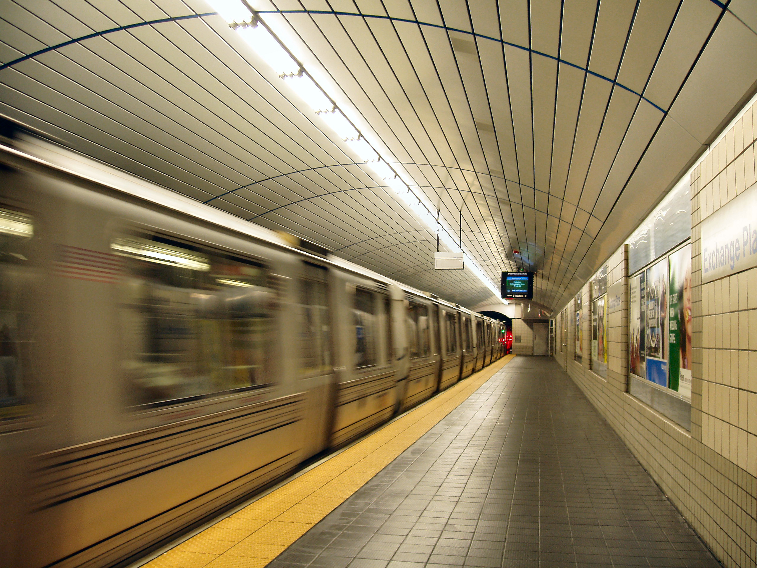
| | | | In Manhattan and much of Jersey City, PATH has regular subway tunnels, as can be seen with this train at the platform of the Exchange Place Station. The line going out to Newark is a combination of open cut, grade, and elevated tracks, as can be seen with this PATH train coming in from Newark towards the WTC. But the most interesting construction is the connection under the Hudson, as shown in this 1909 diagram. Hoboken Terminal with its iconic tower is in the background, and the uptown tubes are illustrated. They are literally cast-iron tubes resting on the river bottom under a layer of silt. Also, the plural “tubes” has more meaning than one realizes. It’s not just a reference to the two Hudson crossings, but also to the fact that each is a pair of one-way tubes, making a total of four. For this first Hudson crossing ever, it was felt there would be better ventilation to utilize the piston effect of a train moving through the tunnel (pushing of air in front and pulling behind), so one-way tunnels were built. (This is less important in vehicular tunnels, where the vehicles do not fill the tunnel as a train does, more like a piston.)
| | | | Service started on the uptown tubes in 1908, when Theodore Roosevelt pushed a button in the White House turning on electric power. The downtown tubes, located 2 km (1.25 mi south) opened in 1909. All four tubes have been declared National Historical Civil Engineering Landmarks by the American Society of Civil Engineers.
| | | | Now we let Pinter pull aside the page of the present and we look at the original plan of the H&M. On the Jersey side we see the H&M as it was built, to connect the Lackawanna’s Hoboken Terminal, the Pavonia Terminal of the Erie RR and the Pennsylvania RR Station at Exchange Place (ferry routes are also shown). It is interesting to reflect back to see what it is these three stations connect today as opposed to then. Then we have a surprise. We see that originally, a connection to the fourth terminal, of the Jersey Central, was actually planned, but never built. This map also predates the later, lengthy connection westward to Newark Penn Station.
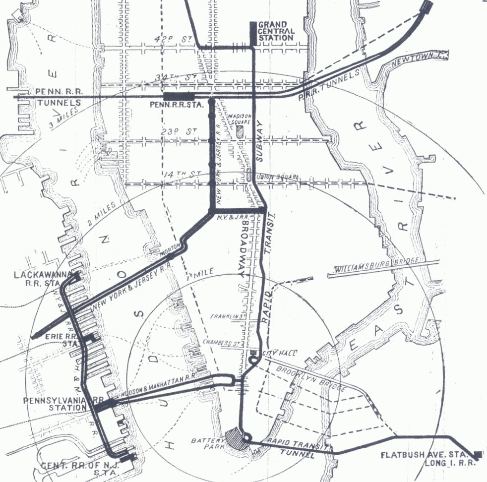
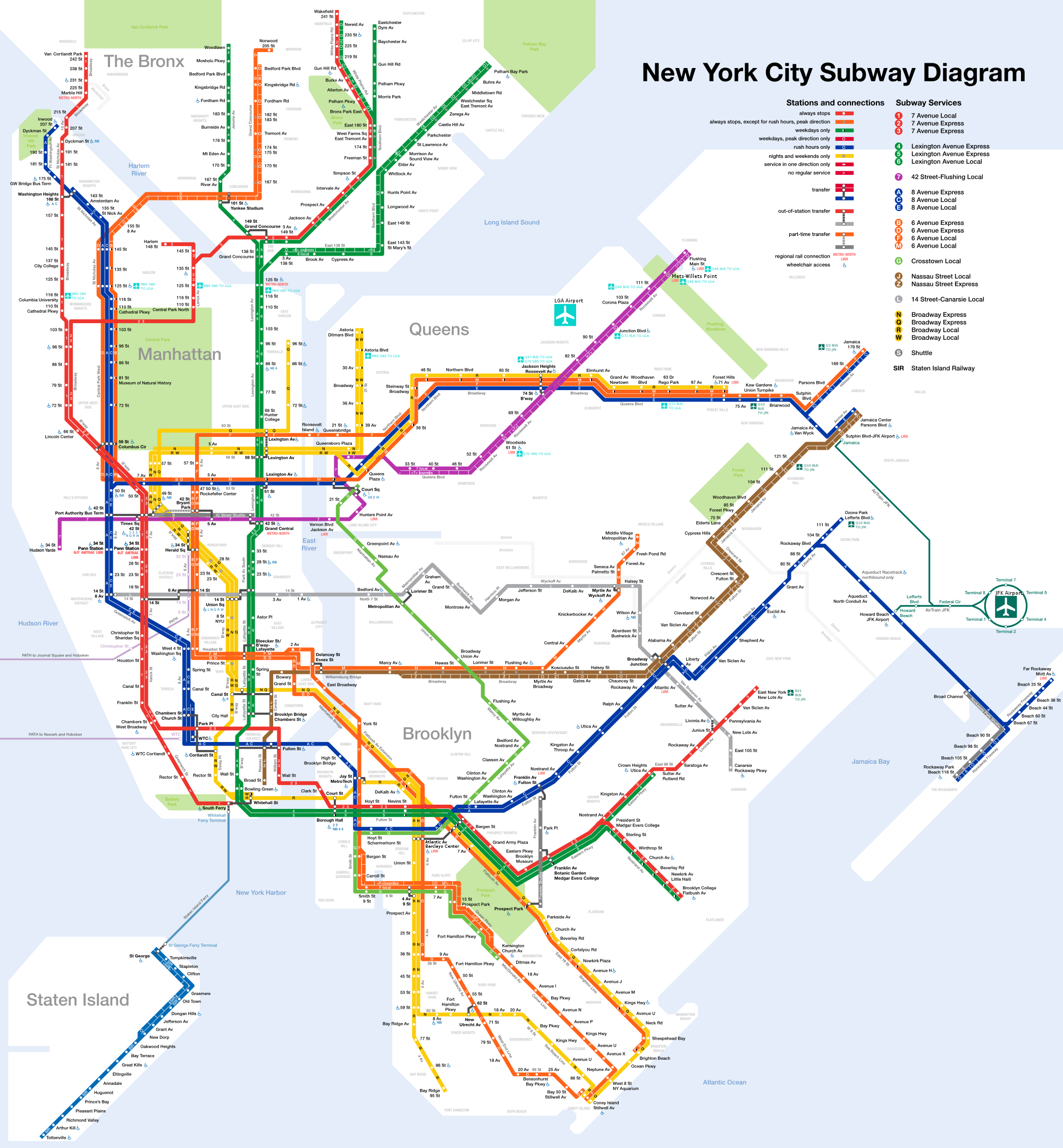
| | | | In Midtown, what I like to call the Great Connector of the Pennsylvania Railroad of 1910 is shown from Jersey under the Hudson to Penn Station, crossing Manhattan, going under the East River to Long Island City in Queens and then north to the Bronx and New England. As for the H&M, the downtown tubes were as they are today, with the exception of an apparent tiny connection to the east side of some sort was never built. The uptown tubes are also the same, missing Penn Station by a long block, but again, it’s apparent that a major connection intended to connect to the east side at Astor Place was never built. In addition, not shown at all was a proposed extension to Grand Central Terminal that never happened. | | | | But to fully comprehend the “East Side, West Side” railbuilding mindset of the time, we have to do another Pinter. Consider all the NYC subway routes of today (Map by CountZ at English Wikipedia), and remove in your mind all the additions you see from the original zigzag line on the older map. Let me help you. On the modern map, after noting the miniscule PATH lines, trace the red subway from 145th Street south to Times Square, the black 42nd Street Shuttle to Grand Central, and the green subway to Brooklyn Bridge-City Hall (shortly afterward extended down Broadway to Brooklyn). Now go back to the old map and study this route (which has more detail at Brooklyn Bridge including the City Hall Loop, to be discussed in the future). Given the mindset of the Aughties (first decade), the H&M was just the West Side equivalent of the single line that was simply called the Rapid Transit Subway, which grew, while the H&M did not. If the H&M was not able to service the East Side itself, it wanted to connect to the “Rapid Transit Subway”, completed in 1904, which DID reach Grand Central, with the additional benefit of reaching what is today the Atlantic Terminal in Brooklyn and was then called Flatbush Avenue Station. However, the West Side (H&M) and East Side (NYC Subway) never did connect directly, and, still having different ownership, still does not. | | | | The PRR “Great Connector” As the 20C started, the H&M was the first to tunnel under the Hudson in 1908 and 1909, but the Pennsylvania Railroad built in 1910 what I like to call the Great Connector. While the H&M allowed passengers arriving in Jersey City to avoid taking a ferry, transferring to the H&M was still a “two-seat ride” at least. The PRR wanted a “one-seat ride” coming from the west into Manhattan--but also continuing on to Boston for through passengers--and so built what it called its New York Tunnel Extension. | | | | [A bridge project had also been considered between Hoboken and W 23rd Street, but it would have been twice the length of the Brooklyn Bridge, would have impeded the busy shipping traffic still active on the Hudson, and would have required the financial assistance of other railroads, which wasn’t forthcoming.]
| | | | The PRR had acquired the LIRR to improve its goal for two-river access to Manhattan. What clinched the deal to build tunnels was an idea that came from Paris: to replace steam locomotives with electric locomotives just prior to the arrival of trains into a city, which allowed tunnels to be much more of a practical solution. The tunnels under the Hudson (two single-track tunnels, seen here from the NY side) and East River (four single-track tunnels) were all completed in 1910, as was the new Pennsylvania Station. Service started in both directions that year as well, to Jersey and beyond and to Long Island and beyond to New England. I call this the Great Connector since this accomplishment was like stringing beads on a necklace, which you can follow on the above map: one bead each for New Jersey, the Hudson, Manhattan with Penn Station, the Lower East River, Long Island, the bridge over the Upper East River to the Bronx and beyond. On the map, the old PRR route to Exchange Place is also shown.
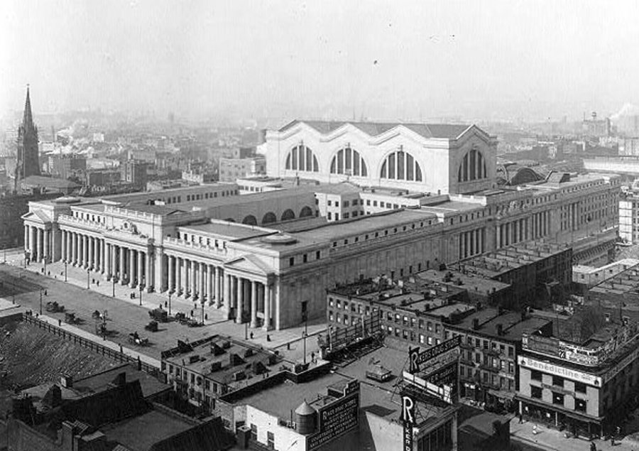
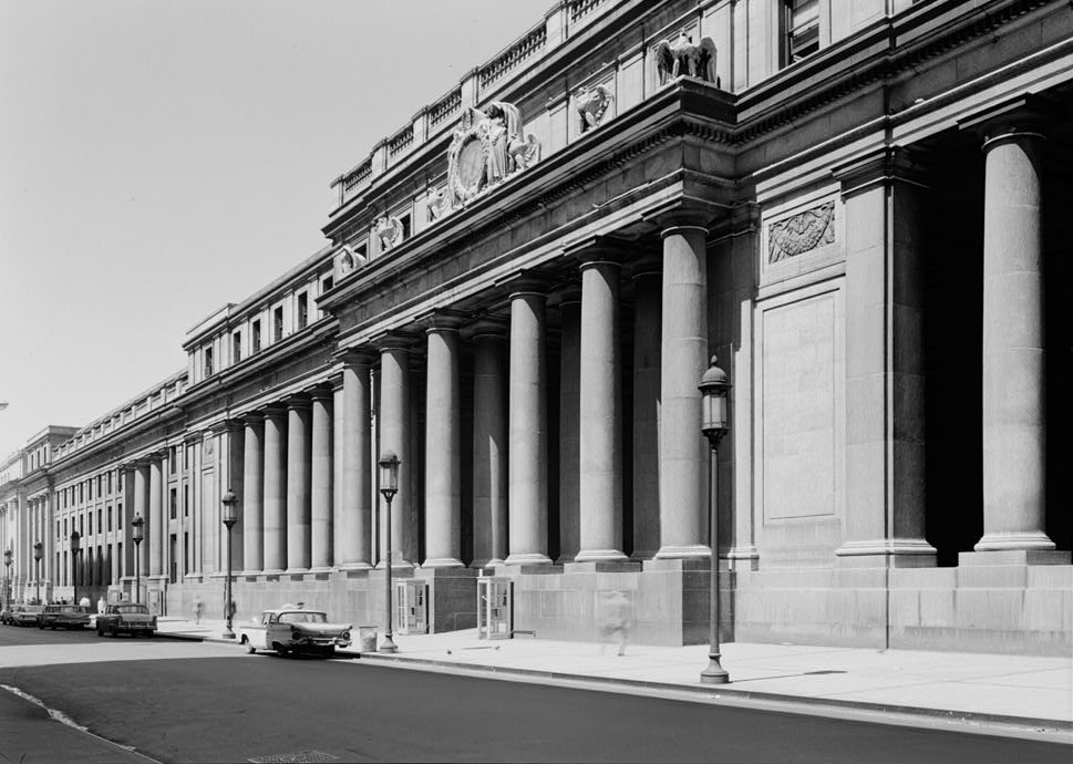
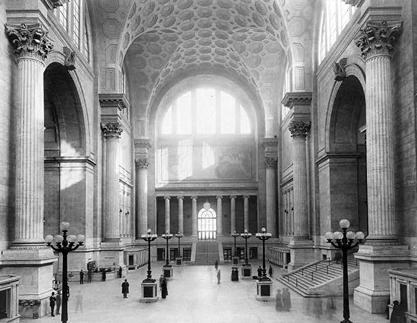
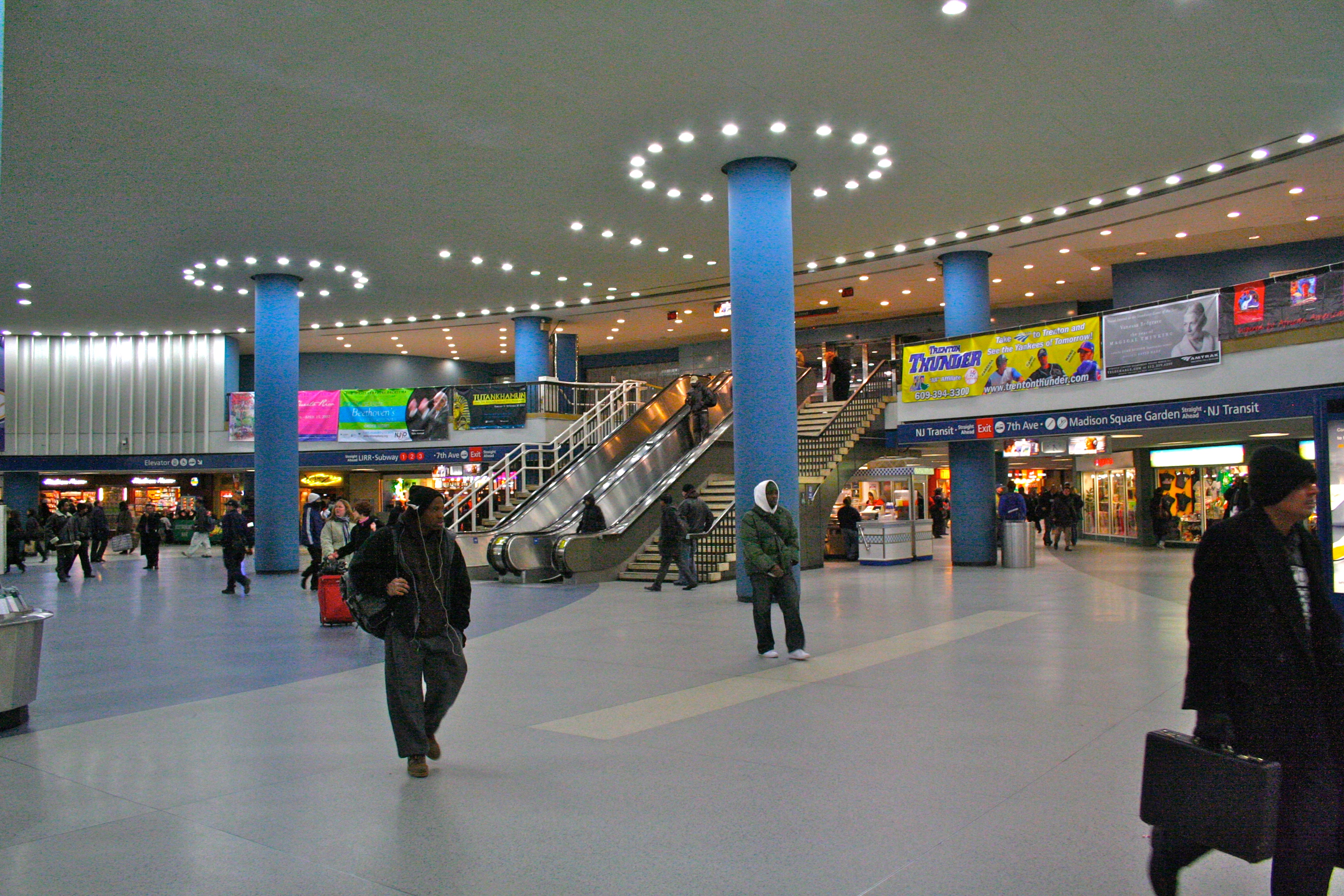
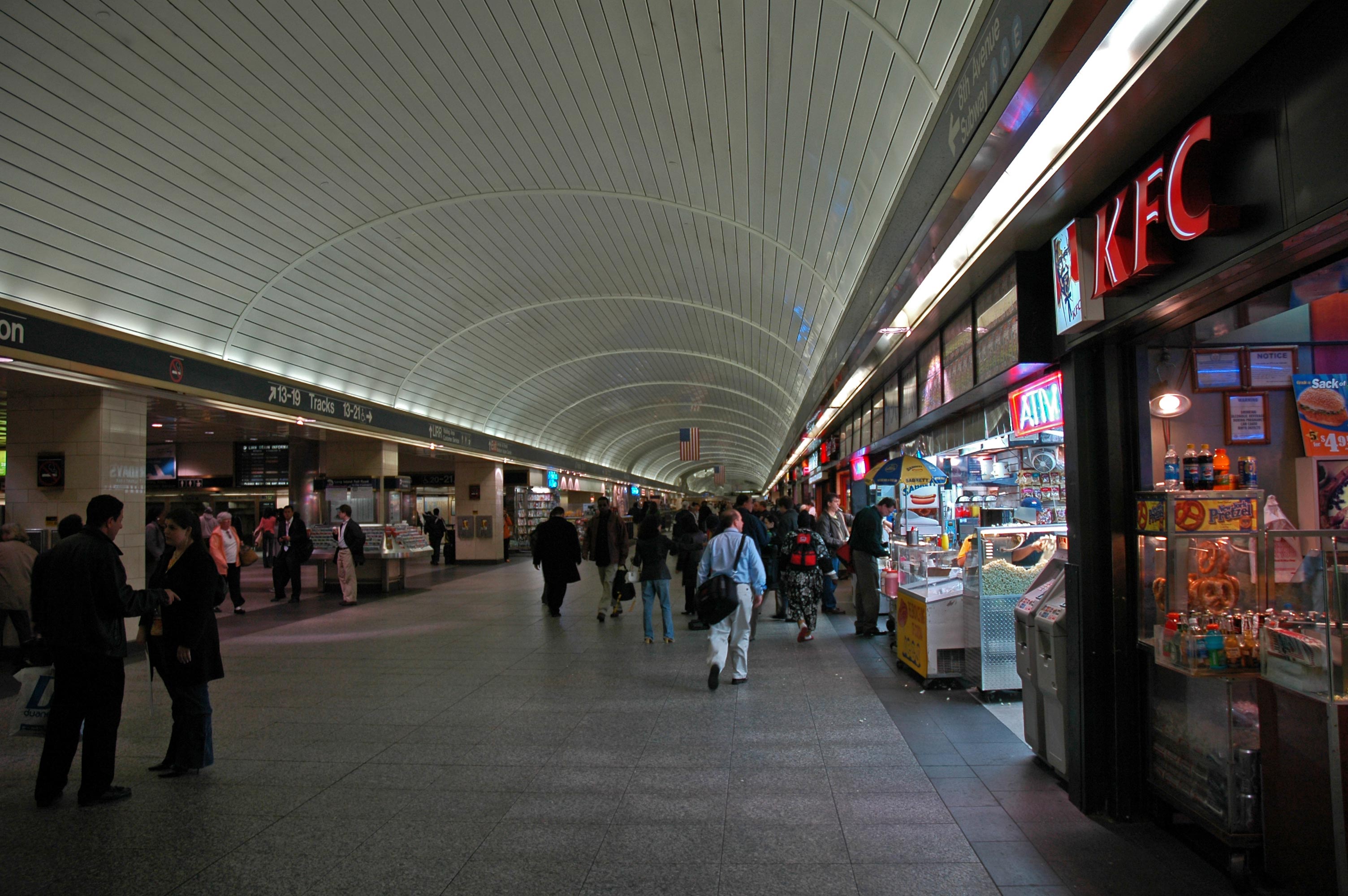
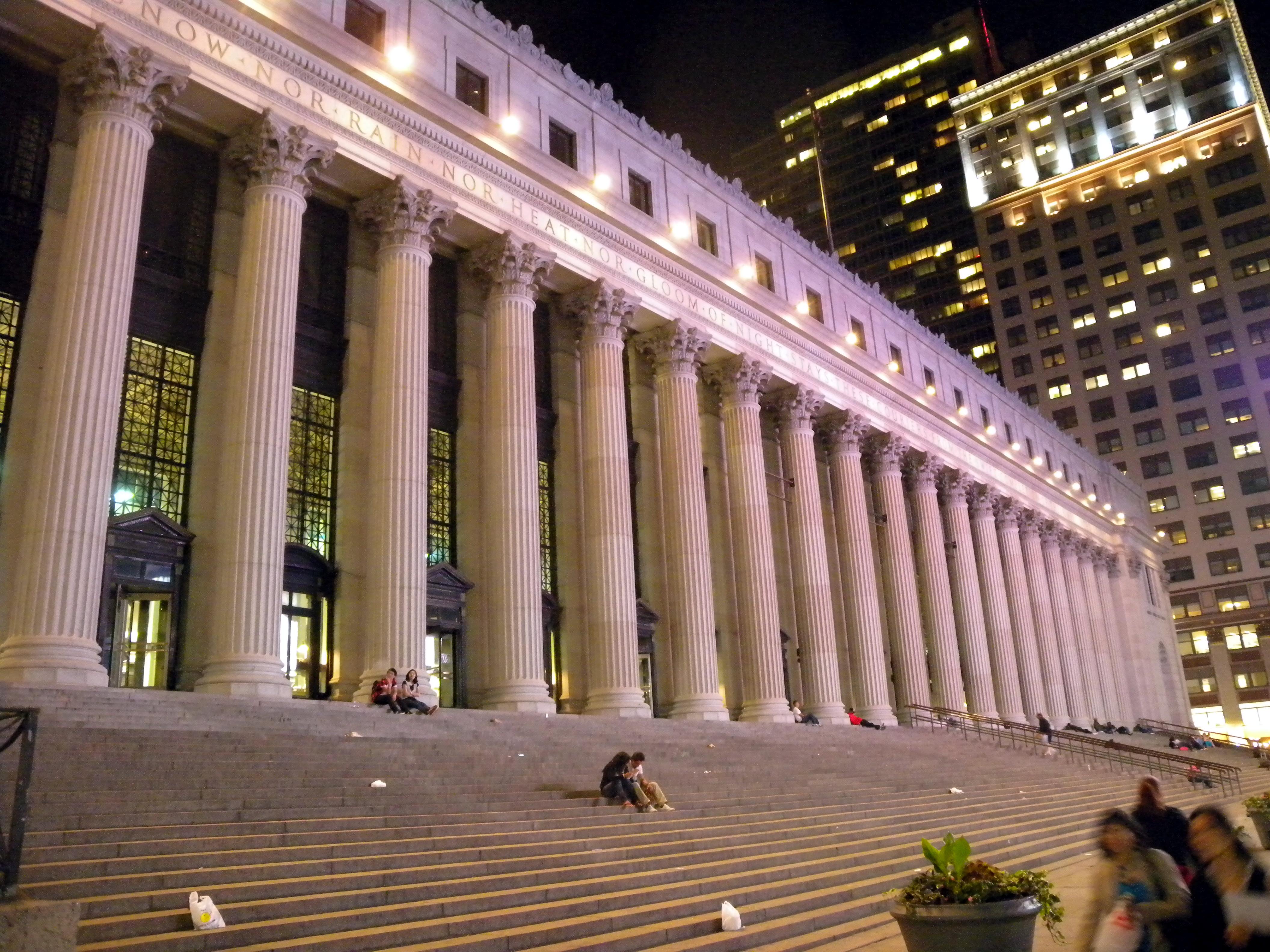
| | | | With 21 tracks, New York’s Pennsylvania Station became the busiest through station in the world. It now houses successor railroads to the PRR: Amtrak and its Northeast Corridor service, including the Acela (2009/27), New Jersey Transit, and the Long Island Rail Road. In recent years, plans have come and gone to add additional tunnels under the Hudson, all still undefinitive, and many of us would still like to see a connection to Grand Central. | | | | Looking at the Northeast Corridor rail service, it should be obvious how the PRR’s crossing of the Hudson made all this possible. (Most of the NEC corridor, shown in red, is owned by Amtrak. Sections in blue indicate commuter rail service as well.) | | | | But as the Pennsylvania Railroad giveth, it also taketh away. We have to refer to the tragedy of Penn Station, which created local, national, and international outrage. While it remains one of the busiest stations in the world, and the busiest station in the US and in North America, the structure is but a remnant of what it was. It today consists of just the underground levels (read: basement) of the old station, which serve as the underground levels of a commercial complex including the latest (fourth) home of Madison Square Garden (which hasn’t been in Madison Square itself for decades). In 1963, the PRR decided to tear down the magnificent above-ground Beaux-Arts structure of Penn Station, designed by McKim, Meade and White, leaving just the rail traffic underground. The only positive coming out of this is the public outcry resulted (too late, unfortunately) in the creation in 1965 of the New York Landmarks Preservation Commission, to enforce preservation laws that were finally in the process of being enacted. | | | | This is what was tragically lost. The massive size of the pink granite Pennsylvania Station (here from the NE in 1911) should be noted, compared to adjacent buildings. The colonnade of Doric columns is shown here in 1962, just before the destruction. Twin carriageways, modeled after Brandenburg Gate in Berlin, led in from the street. The huge main waiting room was inspired by the Baths of Caracalla in Rome and was about the size of Saint Peter’s nave in Rome. It was the largest indoor space in New York City, and one of the largest in the world. Compare that with today’s Amtrak Concourse, LIRR Concourse, and NJT Concourse, all below street level in the “basement”. | | | | It had been a monumental entrance to New York City. While still a major entrance, it is far less than something monumental. The only hope for the future lies one block westward, where the former Beaux-Arts Farley Post Office, shown here when it was built in 1912, stands over the tracks. It was also built by McKim, Meade and White and has the longest oversized Corinthian colonnade in the world, above which is the location of the famous motto “Neither snow nor rain nor heat nor gloom of night stays these couriers from the swift completion of their appointed rounds”. The late New York Senator Daniel Patrick Moynihan championed this building being converted into a new monumental station. His followers want the changed Post Office to be called Moynihan Station. This project, too, has been in the works for quite some time, but still with little result. We keep on hoping. | | | |
| |
|
|
|

