|
Reflections 2011
Series 19
August 9
New England Thrice-2A: LIRR to Boston - MBTA - "Charlie"
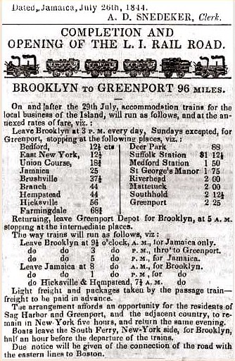
| | Rationale Just as one point driving the islands trip (2011/18) was the unique transportation, trying to duplicate as closely as possible via high-speed catamaran coastal travel as it once existed, the initial inspiration for this trip was also unique transportation, using the Long Island Rail Road to go to Boston, which was the original reason for building it. | | | | But it was the area around Boston I wanted to really spend time in during my week in the area, having revisited Boston’s downtown again recently when I first spoke of the LIRR route (2006/11). I wanted to go beyond, to Salem (with Saugus), to look at two centuries of very remarkable history, the 1600’s (houses, witch trials, iron works) and the 1700’s (China trade, Federal architecture). Then I wanted to visit the war sites of 1755 Boston, followed by Concord and Lexington, and then by Sudbury, to stay at Longfellow’s Wayside Inn. Because of the wealth of information involved, this trip is discussed over four postings. | | | | LIRR to Boston The history of the railroad is in the above posting, but here’s a quick summary particularly à propos Boston. There were a dozen years of incorporation and construction of the LIRR (1832-1844): the Brooklyn & Jamaica was incorporated in 1832 and completed to Jamaica in 1836; the LIRR was chartered 1834 to extend the line to Greenport (at Orient Point on the North Fork of LI) to be part of an 11-hour service to Boston, connecting directly at Greenport station by ferry to several New England railroads in Connecticut (rail-sail-rail). The LIRR bought three steamboats for service (1) up the Thames River in Connecticut (past New London) to the Norwich area, and also (2) to Stonington CT (today a 22-minute drive east of New London). | | | | But rail service from New York to New Haven also started in 1844, headed for Boston along the “impossible” country of southern Connecticut. And there was still competition from direct steamboat service from New York/Brooklyn to Boston. This competition first caused the sale of two of the steamboats to a partner railroad in Connecticut in 1846, and the third in 1847, which effectively ended the express service to Boston. And two years later, what can be considered a “final blow” even though the LIRR Boston service was already over, was the extension built from New Haven to Hartford, Springfield, and Boston via the inland route by 1849. In addition, in subsequent years the so-called Shore Line was extended east from New Haven to New London and via Rhode Island to Boston as well, right into and through the area the LIRR and its partner railroads had been trying to service. | | | | So the LIRR Boston service lasted only three years, 1844-1847, but the boldness of its planning still presented the challenge of duplicating it as closely as possible today. I hereby report that, not only is it doable, I did it, although it does take about twice the time of a one-seat rail connection. | | | | As you see on the following ad, revenue service from Brooklyn to Greenport started on 29 July 1844 and took 3 ½ hours to cover the 96 miles (155 km). Realize that the drawing of the train on this ad is presumably accurate. Note that from Day One they used the quirky spelling of “railroad” as “Rail Road”, and it remains so today. Note the prices: 12 ½ cents to local Bedford (today Nostrand Avenue) or East New York; twice that, 25 cents, to Jamaica; and $2.25 for the whole trip to Greenport, which had taken 2 ½ days by stagecoach up until then. See other comments at the bottom about East End residents now being able to day-trip to New York/Brooklyn, in contrast to the stagecoach trip. This is the equivalent of airplanes in the 20C suddenly allowing cross-country day trips. See about the connections from South Ferry, Brooklyn side, to South Ferry, New York side. And note in the last sentence that they’re getting ready to set up connections from “the road” (the railroad) via uncited ferries to “eastern lines to Boston” on the Connecticut side. This is a thrilling document.
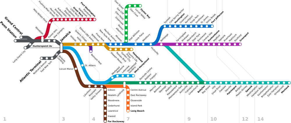
| | | | So how does one duplicate a rail trip like that 167 years after the fact? With substitutions, certainly. And with happenstance. By chance I did it in July, not remembering that the original trip was also in July. But I did it a bit early, on 18 July, eleven days before the anniversary of 29 July. Close enough. | | | | In 1844 I would have walked over to South Ferry, New York, and crossed over to South Ferry, Brooklyn, where the LIRR train would have been waiting on the waterfront at the end of Atlantic Avenue. It then would have proceeded up the hill to the location of the present Atlantic Terminal, at Flatbush Avenue, and then continued beyond. None of this exists today. So I instead wheeled my bag over to the subway and took the R train at Rector Street five stops to Atlantic Av/Pacific St at Atlantic Terminal, where I armed myself at Starbucks with a caramel cappuccino and an apple fritter for the trip. (Good start.) | | | | In the day, the train would have been direct out of Brooklyn, but it would have been an early, smoking, cinder-blowing steam engine. Two things have changed. Trains by law have to be electric in the city (and, practically speaking, also near the city), and Brooklyn lost the lead as main terminal a long time ago (see that history in 2006/11). So let’s look at a schematic of LIRR routes (with payment zones) today. | | | | Atlantic Terminal (Flatbush Avenue) is secondary to Penn Station today. Long Island City and Hunterspoint Avenue (opposite Kips Bay) are by far the least-used western terminals, and were the terminals for ferries to Manhattan before Penn Station was built (see Kips Bay 2011/18). Most LIRR lines are either short, or branch lines, and over time, I’ve traveled on a number of them, at least in part. But it’s the two long lines that stand out, the one to each fork of the East End. We discussed the Montauk Line (2011/10) to Sayville for Fire Island and to East Hampton & Montauk for the East End. When I was in East Hampton last year I drove up to the North Fork to scout out Greenport and Orient Point for this very Boston trip, so I was aware how things looked and where to go, to lessen the pressure of schedules when actually doing it.
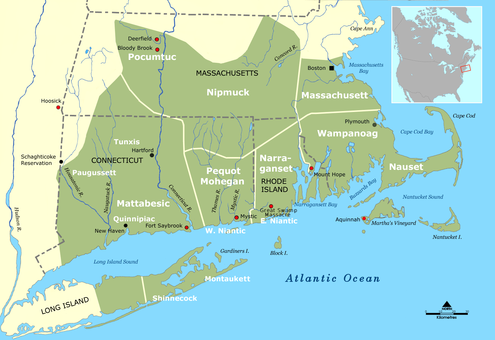
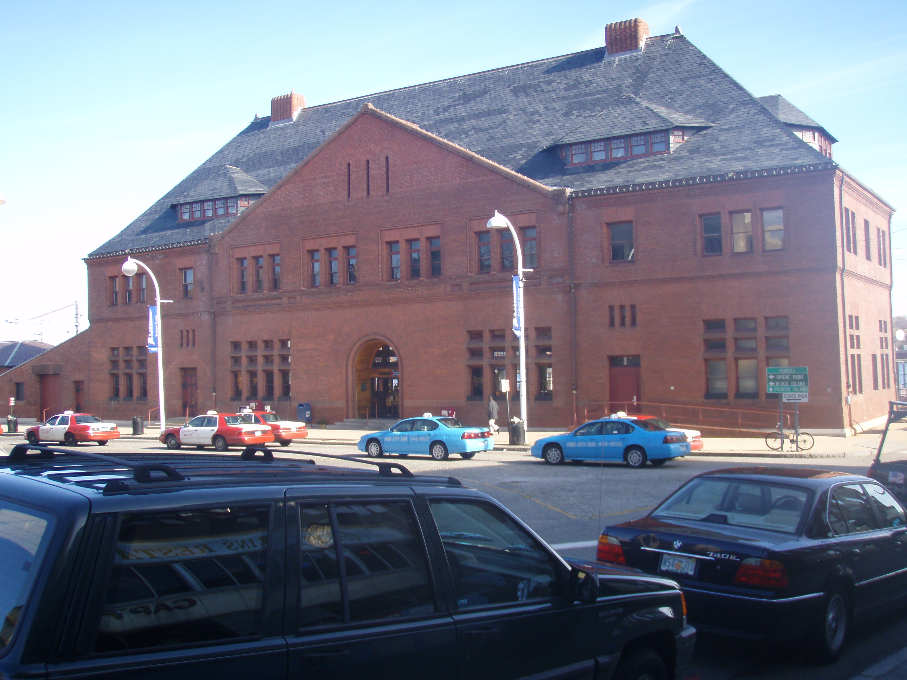
| | | | The upper of the two long lines, the one to Greenport, is to this day called the Main Line, precisely because of the history we’re discussing, even though in its entirety, it’s the least used line in the system today. For instance, weekends there are only two trains a day each way all the way to Greenport, and that only from May to October. But weekdays are better, with one well-timed morning train (that I took) reaching Greenport, plus two evening ones. (Ironically, there are also three inbound trains, and, if they’re willing to catch the one at 5:30 in the morning out of Greenport, East Enders can still can day-trip [or commute to work] in New York/Brooklyn, just as they could 167 years ago.) | | | | Oddly, Main Line trains going all the way to Greenport run out of Long Island City, so it requires a change at Jamaica whether you’re coming from Penn Station, or, as I did for historical reasons, from Brooklyn. However, they are electrified only to Ronkonkoma (ron.KON.ko.ma--see map), so a change is required there to a diesel train. Since different sections of the Main Line are serviced by branches that take off, they’re known by the branch names. The remaining, eastbound part is known as the Ronkonkoma branch, for trains that terminate there, and otherwise the Greenport Branch. As you can tell, different sections of the Main Line are serviced by branches that then take off, but the so-called Ronkonkoma and Greenport “Branches” are just names for the two distant sections of the Main Line. | | | | So, I left Brooklyn at the reasonable time of 9:05, changed flawlessly at both Jamaica and Ronkonkoma, and arrived in Greenport on time at 12:07. Note that 1844’s 3 ½-hour trip now takes 3 hours, even with changes. Anyway, one “rail” down, with a “sail” and another “rail” to go. | | | | To illustrate the entire route, I once again have to resort to referring back to our oft-used tribal map (click to enlarge), since it is extremely difficult to find maps that show Long Island together with southern New England. First note June’s catamaran route from Martha’s Vineyard, then north of Block Island, and then between LI’s Orient Point (with Plum Island) and New York State’s Fisher Island off the Connecticut coast (partially hidden by the word “Niantic”) and off to NYC. Now picture the LIRR route from Brooklyn, on western LI opposite NYC, to Greenport, on the south side of the North Fork, near, but not at, the end at Orient Point. The ferry leaves from the end of Orient Point to New London, just a bit up the Thames River on its west bank, for my rail connection through RI up to Boston. What to do? | | | | Well, in 1844, the ferry left from the end of the LIRR station platform in Greenport, right where the local Shelter Island ferry still does leave. But in today’s automobile world, things don’t happen in a centralized manner--an in-town location is bad for cars--but in a periferal manner--suburbs offer cars more room--so today’s car ferry (foot passengers allowed) leaves 10-15 minutes further east almost at Orient Point. Suffolk County’s S92 bus makes the connection from Greenport to the ferry nicely, but it comes only hourly and wasn’t convenient, so I “cheated” and arranged for a taxi to meet me to drive out to the ferry. I picked up my ticket and made the 1 PM “John H” ferry of Cross Sound Ferries. | | | | This aerial view of Orient Point (click to enlarge) shows how really very sharp the sandy point is as it points to Plum Island. The actual point is on treed private property (dark spot), and the ferry terminal area is the first light spot on the south side. As the ferry swings out, it turns the point for a perfect view of both the point and Plum Island--very nice. | | | | This view is on a sharp angle towards the northeast; Fisher Island NY is not visible, but the far river reaching inland is the Thames, and New London is just inland on the close shore. The whole crossing took 1h20, so we arrived at 2:20 for a train leaving at 2:58--just perfect. Again note that, just as the 1844 ferry started at an earlier point, it also ended at a later point, going up the Thames past New London to the Norwich area, so I’d imagine the ferry ride was longer then. But today, New London proudly boasts an intermodal terminal, serviced by Amtrak, a small office of Greyhound buses, and the ferry landing located a few steps away. Actually, I had to walk a couple of blocks beyond to find a grade crossing, then come back to the station. | | | | I had read a few weeks ago in the New York Times about the plaza and fountain that had been built across from the New London station, and stopped to see it. It was rather unique, since the unbordered fountain consisted of a rather large whale’s tail reaching well above one’s head as the whale had supposedly breached and was now diving below. Water cascaded off the tail. I liked it, but was startled at the sign that pointed out that although whales are protected today, in past years, whales and their oil were so important to the development of New London. Who knew? I’d thought it was more or less limited to Nantucket and New Bedford, just to the other side of nearby Rhode Island. | | | | Across the street, the recently restored New London Union Station (in the day, it had been the union of the New Haven RR and the Central Vermont RR) had its back to the river and presented its splendid 1889 face to the city. It was designed by none other than H H Richardson himself, famous for the big round arches typical of what was called Richardson Romanesque, although in this case, only the main entrance has a smaller version of his signature arch. It’s on the National Register of Historic Places. The warm restoration of the interior was equally impressive. | | | | The train was on time and followed the Northeast Corridor shore route from New London via Providence RI to Boston, arriving at South Station on time at 4:49. This train had left Penn Station in New York at 12:30, so I could have had a “one-seat” ride in 4h19, which is about 56% of the 7h44 my multiple-seat ride had taken (as compared with the 11 hours suggested for 1844). But why do it the easy way when you can do it the historic, fun way? | | | | Also note on the previous map what would be my change of plans for going home a week later. I’d tried something funky and purchased tickets from Boston to Albany, since I’d never ridden E-W through Massachusetts, and then down the Hudson to New York. However, I was informed by email three days before my return that, because of construction, the Boston-Albany route was out of service for the following week, just when I wanted it, so I decided to return directly to New York via the high-speed Acela train, this time trying business class which was quite nice. Maybe I’ll try Boston-Albany again another time. | | | | The MBTA and City Travel by Train My visits to the outlying areas around Boston were to be accomplished by train as well, although again some taxi help was needed. I also visited/revisited some Boston locations, using some (excellent) bus connections, and more subway connections than I’d originally planned. This is totally possible to do in cities in the Northeast. I am not anti-car when traveling, since it’s a good way to have a pleasant, flexible-route drive in the countryside, but there was no need on this trip, connecting cities and towns, to rent one. | | | | I should expand on what I’ve just said about the US Northeast. Just as the more populous centers of the US Northeast (also Chicago; also Toronto, Montréal, Québec) favor long-distance intercity travel via Amtrak (or via VIA in Canada), so is local commuter rail service far more plentiful. There are only six commuter rail systems in the US that carry an average of over 100,000 passengers a day : LIRR (New York, 345K); New Jersey Transit Rail (New York & Philadelphia, 302K); Metra (Chicago, 297K); MTA Metro North (New York, 286K); MBTA (Boston, 129K); SEPTA Regional Rail (Philadelphia, 125K). As much as I want to see other cities expand their systems, and enjoy hearing when they do, all other systems fall way below the above in ridership, with positions 7 and 8, those of San Francisco and Los Angeles, each having a ridership of only 30% of the lowest figure above, and Baltimore and Washington, while nevertheless lying at the southern end of the Northeast Corridor, take positions 9 and 10. The only Canadian city to join the 100K circle is Toronto, whose GO Transit figure is 217K. | | | | Of these 6 + 1 best-served cities, Chicago and Toronto stand apart by their locations in the interior of the continent, while Boston (1 system), New York (3 systems), and Philadelphia (2 systems) line up in a row on the upper east coast, forming the bulk of the Northeast Corridor. It can also be seen that New York City is the most favored with service. About 1/3 of the users of all mass transit in the US and 2/3 of the rail riders live in the New York City metropolitan area, and the two busiest passenger rail stations in the US are New York’s Penn(sylvania) Station and Grand Central Terminal. Also, outside of the dozen or so cities mentioned, commuter rail in North America is unfortunately more infrequent and less extensively used relative to networks in European and Japanese cities of comparable size. | | | | In any case, seeing the Boston area by train is easy. In 1964, the MTA (Metropolitan Transportation Authority) widened its horizons and became the MBTA (Massachusetts Bay Transportation Authority), covering subways, commuter rail, buses, and ferries in a widened service area, actually now encompassing the entire eastern third of Massachusetts. The system is known locally as “The T” because of its logo, which is a capital letter T enclosed in a circle, apparently based on the word “transportation”. This logo was inspired by the Stockholm Metro,Stockholms tunnelbana (2006/8), which uses exactly the same logo, but based instead on the word tunnel, since the above Swedish word for “subway” is actually “tunnel railroad”. This is an MBTA Commuter Rail map, to help follow the Boston commuter rail adventures. | | | | The first thing to realize is that Boston is actively improving, restoring, and extending its system. The three lines running toward the SE, the so-called Old Colony Lines after the defunct Old Colony Railroad that we discussed with Cape Cod (2009/27) were closed to passenger service in 1959, at the height of the “bad years” for closures of railroad service. Then, as pollution issues from expressways deepened, the MBTA restored service in stages from 1971 (Quincy Center) to 1980 (Braintree) to 1997 (Middleborough and Plymouth) to 2007 (Hingham). The Stoughton line is being extended to Fall River and New Bedford. An 32 km (20 mi) extension SW beyond Providence is being considered to other destinations in Rhode Island. The Fitchburg line is to be extended a bit. There is talk of another line from Worcester, this one into North Station. Connections into New Hampshire are also being discussed. Most spectacularly, there has been discussion to extend service W to Springfield, 2/3 of the distance across the state, which would then connect with Amtrak N to Vermont and S to Connecticut and New York. In addition, there is discussion between MBTA and Connecticut to extend commuter rail, in addition to Amtrak, south from Springfield to Hartford and New Haven. It is mind-boggling that, under the guise of local service, interstate service covering a good piece of New England is being either built or considered. Perhaps the worst of the mid-20C bad years are finally on their way out. | | | | [Tangential, but related, positive news: I have five decades of experience with Minneapolis-Saint Paul, which for decades had had no rail service of any kind, with the ensuing traffic congestion and pollution. Then came the reintroduction of light rail a few years ago with the construction of the Hiawatha Line from a terminal downtown at Target Field S to Bloomington. Since then, rail plans have exploded. Virtually all the following routes are reconstructions of either streetcar lines or rail routes that were killed in the mid-20C. We tear down, and we then build it again. Anyway, also connecting, or planned to connect with the Target Field Station is the Central Corridor light rail E to Saint Paul; Southwest Corridor light rail to Eden Prairie; and a possible Northwest Transitway as the fourth light rail line. The lower part of the station is for heavy rail, including the present Northstar Line commuter rail going NW, eventually to Saint Cloud; and the Red Rock Corridor commuter rail, E via Saint Paul Union Station and SE to Hastings and eventually Red Wing. To me most surprisingly is the planning, also from Target Field Station, of regional trains, starting with the Northern Lights Express, an intercity train northeast to Duluth/Superior. There is also talk of rail lines E to Wisconsin, SE to Rochester, S to Iowa, then beyond to Kansas City, W to South Dakota, NW to Fargo/Moorhead, and, I’m most glad to hear, beyond Fargo N into Canada, to Winnipeg, Manitoba. Also, for many years, Amtrak’s Empire Builder stopped at a small “Amshack” facility called Midway Station between the Twin Cities. There are now plans to move it to Saint Paul Union Station, presently being refurbished. This is all quite breathtaking.] | | | | But the Boston MBTA story is not perfect. I had difficulty working out my visit to Lexington, since the rail line that had existed from North Station to Lexington and beyond for almost a century and a half was closed down in 1991 due to low ridership. Lexington still has a charming train station used for other purposes, but behind it, the woodsy view looks something like this, since the rails were removed and it is now the Minuteman Commuter Bikeway. This was the decision made, rather than extending the northern end of the Red Line from Alewife, which was the other choice. However, the good news is that MBTA still owns the property and leases it to the municipalities through which it passes on an interim basis, in other words, the right-of-way was not transferred, but railbanked in 1991. Although the rails were removed, trackage can be relaid without objection if the MBTA should find it necessary. This is the same situation we reported on in Atlantic Highlands NJ in 2011/5. | | | | The most unusual thing about Boston commuter and long-distance rail is something that needs to be improved, but will have to wait until funds are available, possibly for quite some time. You may have noticed what I call the “Boston anomaly” when you saw the commuter rail map showing routes to North and South Station. It’s easiest to explain using these maps from the website of the Massachusetts Sierra Club, which is deeply interested in the environmental aspect of many air-polluting commuter cars as opposed to commuter rail. Take a look at the Boston Gap, a unique situation for the entire Northeast Corridor. Most Amtrak routes to Boston come into South Station, but the Downeaster from Portland, Maine, comes into North Station. Beyond that, ALL commuter lines go into either one or the other. No transfers are available. Travelers with a lot of luggage have to take a taxi, those with little (me) or no luggage take the subway, but need to take two lines to connect. For the train traveler, it’s like finding oneself on the South Rim of the Grand Canyon and seeing the seemingly unreachable North Rim in the distance.
| | | | The proposed solution is a tunnel through downtown Boston, similar to the Big Dig tunnel that put the expressway underground, however the tunnel would be expensive enough that the authorities have withdrawn their support at the present time. This is what the North-South Rail Link corridor through Boston would look like (the dotted colored lines are subways). All commuter and long-distance rail routes from the south and west would go through portals underground in the area of the South Station rail yards to a lower-level area of South Station (avoiding the subway), then proceed along the route of the Big Dig to a new, small Central Station near the Aquarium stop of the Blue Line of the subway (which now is the only line not connecting with commuter rail). It would continue to a new low-level area of North Station, then under the Charles River to a portal in Charlestown. It’s an incredible solution to a complex problem, but very expensive. However, after WWII, Brussels was able to connect its north and south stations with a tunnel, including a small Central Station. If Brussels could have done it under postwar conditions, why can’t Boston do it today?
| | | | The improvements would help Amtrak’s gap problem, but would be most noticeable with commuter rail, as shown in this schematic diagram. Instead of routes terminating at one or the other station, northern and southern routes would be connected, so that an inbound northern route would become an outbound southern route, which is extremely efficient. We shall see what comes to pass. | | | | [The situation in New York is not the same, since in 1910 the New York Tunnel Extension was built from New Jersey under the Hudson to Penn Station, then under the East River to Long Island, then over the Hell Gate Bridge towards New England, so there is through service through New York. However rail advocates, including the Empire State Passenger Association (ESPA), of which I’m a member, and the New Jersey Association of Railroad Passengers (NJ-ARP) continue to push for additional Hudson tunnels directly into an expanded Penn Station, as well as tunnels beyond to connect directly to the Lower Level of Grand Central Terminal. There is an additional anomaly in New York. Since there is a different railroad coming from each direction, NJT trains from the west deadhead to Penn Station, LIRR trains from the east do the same (even though the tunnels connect), and Metro-North deadheads to Grand Central. O tempora! O mores!] | | | | To follow the rail lines used on the July trip, let’s look again at the Boston commuter rail map to see the connections made on this trip. My Amtrak train from New London came in via Providence, sharing the MBTA’s Providence line and eventually the Orange subway line, also visible on this map. Out of North Station, I used the Newburyport/Rockport line to connect to Salem on two round trips, and, also out of North Station, the Fitchburg line to go outbound to Concord. (As mentioned, today no rail goes to Lexington.) Note that the map is schematic, and that the two western lines, the Fitchburg line and Worcester line, are actually much closer to each other than shown, one slightly NW and one slightly SW. Since Sudbury, also with no rail service, lies between Concord and Framingham, I took a taxi from Concord to Sudbury, and later a taxi from Sudbury to Framingham, from where I returned to South Station, where I got the Acela back to New York.
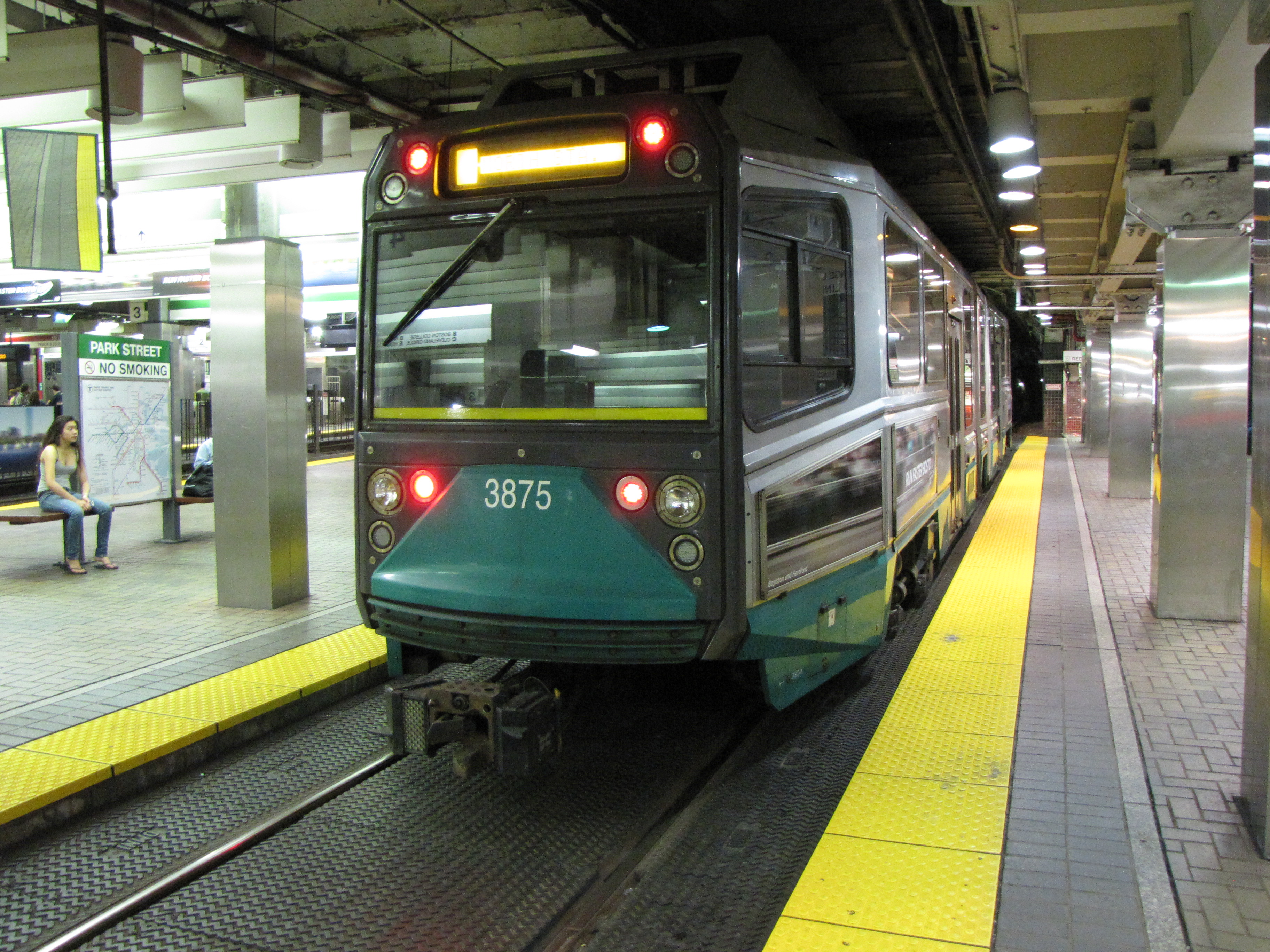
| | | | To complete understanding Boston rail, let’s look at Boston’s subway lines (enlarge at the bottom). First we need to discount the Silver Line, which is rather unique as being a surface bus line that enters what otherwise looks like a subway tunnel downtown, continuing to the airport. Also note that the commuter rail lines are also indicated here for orientation, and that some subway (Orange to the N, Orange and Red to the S) lines cohabit rights-of-way with commuter rail. Beyond that, four colors indicate four lines--and a surprise. | | | | The entire Green Line (plus the [Red] Mattapan Line beyond Ashmont) are not a true subway, but a surface light rail system that ends up underground downtown. However, these lines are the busiest light-rail system in the US with 215K daily boardings. Others over 100K are San Francisco (158K), Los Angeles (154K), Portland (123K), Philadelphia (115K). However, including Canada results in finding both Toronto (311K) and Calgary (253K) at the top of the list. This is the Green Line at Park Street Station. Notice that Green Line platforms are low-level, as though you were in the street above, something I always found striking. On the T, Park Street is considered the hub, so that all trains on all lines going toward Park Street Station are referred to as inbound, and leaving its area, outbound.
| | | | The three true subway (“rapid transit”) lines are the Orange Line, shown here at the new station at North Station, the Blue Line, here at Airport Station, and the Red Line, here at the Downtown Crossing Station (a reference to the streets above forming a shopping hub). Click to enlarge to see the two colors in the distance showing transfers that can be made. Within the US, Boston comes in fourth in weekday ridership: New York subway (7.5 M), Washington (919K), Chicago (638K), Boston (478K), but again including Canada inserts two other cities right after New York, Montréal (1.1 M), and Toronto (948K). | | | | If you check the above subway map, you won’t find a single subway line that connects South and North stations, but there are two possibilities, each using two lines. Since I wanted to include riding the light rail, I took the Red Line to Park Street, then the Green Line to North Station. [I’ll repeat the favorite story I’ve told before: When arriving as a teenager on my first trip to Boston, someone speaking with a Boston accent directed me to change lines at Pack (perhaps Paack) Street, and I almost didn’t get off when I came to what I read as Park Street.] | | | | All in all, the MBTA is the largest consumer of electricity in Massachusetts, and the second-largest land owner after the governmental department that owns parks and parkways.
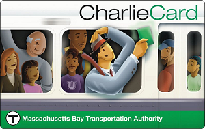
| | | | “Charlie” & the M(B)TA The MBTA since 2006 has used a touchless smart card for fare collection on everything but commuter rail, and that’s promised for the future. You can buy this Charlie Card online for $5 and have it mailed to you (which I did, to save time once there). It comes loaded with $5 worth of fares, with no charge for the card (unlike Miami and elsewhere). Being a touch card, it has an advantage over New York’s Metrocard, which is a fussier swipe card that sometimes needs a redo. Additional value can be very easily loaded onto the Charlie Card at easy-to-use machines that take credit cards (or you can buy a card there in the first place). Upgrading can even be done online, with the extra money added to the card the next time you use it. The card gives discounts, so that a $2 ride costs $1.70 with the Charlie Card. | | | | Now why is it called the Charlie Card? And why on the card is he riding the Green Line? While we talked about it in 2006/11, and even quoted some lines from the song, it’s worth mentioning again. Charlie is of course, the fictional folk character so entrenched in Boston lore that the MBTA wanted to pay tribute to him in this way. He was made popular by the Kingston Trio in their 1959 folk hit The M.T.A. during the period of folk revival of the late 1950’s and early 1960’s. Here the Kingston Trio sings it on TV. | | | | From what I find, the melody is not quite new, but is very similar to two 19C songs, one describing a ship that never returned, and another about a train that did the same. But the more contemporary version was written in 1949, a decade before it became famous, by two Boston women who actually were writing a campaign song for a Boston mayoral candidate, one Walter A. O’Brien. One of his causes was the fact that what was then called the MTA wanted to raise fares 50%, but didn’t want to change entry turnstiles that accepted dimes, so they instead initiated an exit fare of a nickel. The campaign was the reason for the line “Fight the fare increase!”, although the name was changed to George O’Brien (although on this recording it appears as Charlie O’Brien, which might have been an error when performing on TV). | | | | Looking at the map of the T, it’s interesting to compare what the song says to actual fact. Charlie wonders about visiting people in Chelsea and Roxbury. While Chelsea to the NE is served by a commuter rail station, the Blue Line runs south of Chelsea, so that makes little sense. However, it can be seen that the Orange Line does serve Roxbury. Charlie gets on at the Kendall Square Station on the Red Line, which is today called Kendall/MIT. He changes for Jamaica Plain, which the E branch of the Green Line used to serve, all the way down to Arborway, but that was truncated in 1985 by about half to Heath Street (the map is not to scale; people hope the line will be re-extended). That means he changed at Park Street. | | | | His wife visited him every day at the Scollay (pronounced Scully) Square Station. Scollay Square, which had grown seedy but could have been restored was obliterated in 1962 when behemoth government buildings were put up in its place. The station is now called Government Center, but I was glad to see that now “at Scollay Square” was written underneath in small writing on platform signs. Therefore, although he traveled two stops on the Red Line, most of his trip was on the E branch of the Green Line, at least up to Government Center/Scollay Square, hence the green color of the Charlie Card. Doubters and scoffers will of course wonder aloud why his wife didn’t hand him a nickel instead of a sandwich, but where’s the fun in that? | | | | I was particularly interested in watching Dave Guard play that banjo solo, and I wrote to my banjo friend from the Amazon cruise, Peter Mezoian, and asked him to comment. He pointed out once again that, while he himself plays the four-string banjo, Dave Guard is playing the five-string banjo here. Peter has in the past played some Kingston Trio music, but not on a regular basis. He also studied the five-string for a while. He describes the two types of banjos as two “worlds”, two very different musical settings, although the five-string is far more frequently heard and played, particularly in bluegrass music. Peter was kind enough to link my comments on my website about his performance with his website, which is frankly a first for me and for this website. | | | |
| |
|
|
|

