|
Reflections 2010
Series 22
September 25
RTW2 IX: Great Ocean Road - Melbourne - Hobart - Launceston
| | The time between arriving in Melbourne and leaving Sydney on the Indian Pacific had been tight to plan. The train left only twice a week, and not catching the train on the date I had in mind would add expensive days to an already long trip. Therefore, I juggled the days in Melbourne and Tasmania and shoehorned in everything I wanted, and it all worked out. However, it might strike the reader that just two nights in Melbourne, two nights in Tasmania, and one night each on the ship going and coming is squeezing it a bit. It might be, but careful planning made it work out even better than I expected.
| | | | The Overland coming from Adelaide arrived in Southern Cross (ex-Spencer Street) Station in Melbourne, with that wonderfully undulating roof you can’t forget, just as darkness was falling, and I’d planned everything so that all I had to do was cross Spencer Street at the main station exit at Bourke Street, walk up Spencer one block to Little Bourke Street (I’ll explain the “Little” streets later), and half a block in was the Ibis Hotel, the third one I’ve stayed in after Wellington (twice) last year and Brisbane a couple of weeks ago. This Ibis was hidden on a quiet street, but just as cozy and comfortable as the others. I’d eaten on the train, so all I had to do was post the latest items on the website then go to bed early for an early start--west of Melbourne.
| | | | Great Ocean Road The only way I could get to see the Great Ocean Road (GOR) was to do it on the first day, then see Melbourne the next day, and the best way to do it was not by driving myself but by taking a tour, given the large distances involved, and therefore the long trip. I (or perhaps I should say The Hat and I) had to be ready for a 7:40 AM pickup and didn’t get back until 9:05 PM, which is almost a 13 ½ hour day. At least I could sleep on the bus in the 1 ½ hours to get there, on some of the long stretches in between, and on the long trip back after dinner, and at least it was a small bus with not too many passengers. | | | | The coast to the southwest of Melbourne forms an open V, the point of the V being Cape Otway. It has to be pictured in three parts. The first is the southeast-facing part of the V, the oldest, which faces Bass Strait. The second is the middle part added later, cutting overland to bypass Cape Otway. The third is the southwest-facing part of the V, which faces the Southern Ocean directly. The entire GOR is considered one of the world’s great scenic roads. | | | | THE SURFCOAST The first third, the original part, of the Great Ocean Road,seen here near Lorne, was built after WWI, using as a guide the coastal highways in California, which it quite obviously resembles, given the cliffs with surf below. It was meant, rather unusually, as a memorial to the war dead and is therefore the world’s largest war memorial. It was also meant to provide work for unemployed returning soldiers. The early part of the highway, closest to Melbourne, the part that faces southeast, took from 1919 to 1932 to build, since it was built entirely by hand, that is to say, by pickaxe, shovel, and wheelbarrow. The communities it connected had been only reachable earlier by sea or occasionally, by inland roads.
| | | | The weather did cooperate with us for the trip--mostly. It was either blue sky or partly cloudy, and was not too cold for both a sweater and jacket. But what plagued us on and off was the wind--but that’s what this entire coastline is all about. The southeast stretch of road on Bass Strait is promoted as the Surfcoast, and our first stop was at Bell’s Beach, which is apparently famous for good surfing. The whitecaps below the cliffs were formidable, but no one was out surfing, given the wind. It was supposed to be a tea break, and drivers from other companies were trying to set up tea on picnic tables, but our driver, Jon, decided to postpone tea because of the wind. We drove into the attractive town of Lorne and to a hillside park on its west side with views, and Jon set up thermoses with hot water, tea and (powdered) coffee, and a tin of biscuits. There was no wind and a nice view, and here, there were two surfers. While we were there, a very large bird landed on the grass, which Jon identified as a kookaburra, which can grow to 28-42 cm (11-17 in).
| | | | We proceeded a bit to a turnoff that all tour drivers were apparently aware of, although I didn’t see any private cars pulling off there. It turned out to be a two-part fauna stop. It was just a narrow side road bordered with eucalyptus just steps off the GOR, and several small tour buses were already there. You just had to notice where people were staring up to know what to look for yourself. First were the wild koalas, chomping away at their favorite food, eucalyptus leaves. These Victorian koalas were noticeably larger in size then the ones further north had been, a point Jon made, but which was easily visible. Further up the road--even Jon was happy to see this--were not one but two mother koalas, each with a joey clinging to her, all four chomping away on leaves.
| | | | The other fauna sight on this road was much more visible: there were dozens and dozens of parrots (and the odd cockatoo). Jon named the most common ones, but they were everywhere. The drivers had supplies of bird seed--which is probably why the wild birds knew to show up here--and poured a bit in your hand. I ended up with 3-4 birds on me at once, one pecking away at the seed in my right hand, one on my left shoulder, and 1-2 sitting on the easy, flat-topped perch of The Hat. These were all good-sized birds, and all the fluttering of wings from person to person was spectacular.
| | | | When I took a eucalyptus leaf to crush and smell I was surprised to find the strongest eucalyptus scent I’d ever experienced. Jon said that eucalyptus leaves were added to billy tea because the eucalyptus oils helped clarify the stagnant billabong water. I don’t know how accurate that may be, but it sounds plausible. We then stopped at Apollo Bay for lunch, which ended our ride on the Surfcoast part of the GOR.
| | | | CAPE OTWAY The central Cape Otway region is covered by Great Otway National Park, and the GOR doesn’t go down to the cape itself, but cuts across somewhat inland. The region is covered by a cool, temporate rainforest, and we stopped at the main trail to see the local flora. The trail took about 20 minutes, and by taking it, you left the present and entered the past. This temperate rainforest here in the south contrasted from the tropical Daintree Rainforest in northern Queensland. Here the trail, partially boardwalk, passed streams, large, bold ferns, and ancient trees. Most striking of the trees was the myrtle beech, because of its size. They can grow to 30-40 m (98-131 ft), and were once thought to be the tallest tree in the world, until the California redwoods (2008/19) became well-known. Jon stood in front of a magnificent example of one, and appeared ant-sized. I think of all 21 people on the tour huddled together, their combined footprint wouldn’t be as big as that of the trunk of this myrtle beech.
| | | | THE SHIPWRECK COAST A little doze on the bus later and the GOR had crossed the cape and we were back on the coast. This southwestern side on the Southern Ocean is referred to as the Shipwreck Coast, and is very unusual--and it was quite windy once again. The best way to understand what’s happening here is to visualize two similar images. First picture a sugar cube that gets wet on one side and starts to disintegrate. Alternatively, picture a sand castle on the beach being licked by the incoming tide, with turret after turret being eaten away and collapsing into the sea. The Shipwreck Coast consists of limestone and sandstone, both soft, and is constantly being eaten away by the rough seas and winds coming up from Antarctica. It is remarkable that the coastline here is being eaten away by wind and sea at the amazing rate of 2 cm (¾ in) per YEAR! All the famous rock formations here in Port Campbell National Park, notably the 12 Apostles and London Bridge are gradually disappearing. Picture again the sugar cube and sand castle, since that’s the only way one can fully appreciate the events here. | | | | 12 Apostles When we arrived at the 12 Apostles we had by far the most fierce wind of the day. Jon dropped us off at the visitor center from which the paths led out to view the coast, while he brought the 4-5 who’d signed up for the helicopter tours of the 12 Apostles to their ride. A flight hadn’t attracted me at all, since I could tell you’d just be seeing the same thing, but from higher. I’d learned at Uluru that that’s no big thing, as contrasted with my first helicopter flight at Victoria Falls, from which you saw things you in no way could have seen from the ground. I now know that when signing up for a helicopter tour, caveat emptor / let the buyer beware.
| | | | The sun was out, but the wind was so strong you had to lean into it in order to walk along the path. What do to in general? What to do about The Hat? Piece o’ cake. Ever since Eleanor Hardy at the Society of International Railway Travelers had distributed gifts of lightweight, blue jackets to its members a couple of years ago, it’s become my travel jacket of choice. Just the SIRT logo alone frequently evokes comments. Well, the jacket has a hidden hoodie in the collar, which I’d already had occasion to use in the rain at Uluru. In this case, I put the hoodie out and around The Hat, and pulled the drawstrings tight. Leaning into the wind, The Hat and I marched out to see the 12 Apostles, confident that The Hat would not end up being worn by one of the apostles.
| | | | The 12 Apostles are columns left by the retreating coast, or, as I managed to copy into my notes from the explanatory sign by the footpath, they’re the “temporary remnants of a retreating limestone coastline”, a turn of phrase I particularly liked. The formations had been named the Apostles, but in time, people started calling them the 12 Apostles, even though there never were more than nine. Recently, another fell into the sea, so the 12 (9) became 8. Photographs go out of date quickly here. However, given the rate of erosion, it’s expected that existing headlands will end up as new columns in the future. Sugar cubes and sand castles.
| | | | Loch Ard Gorge Many ships were wrecked on this section of coast, giving it its name. The most famous one was in 1878, when the clipper ship Loch Ard, named after a loch in Scotland, after three months’ voyage from England and a day short of their destination of Melbourne, ran aground in fog, giving the reference to the name Shipwreck Coast. Of the 51 passengers and crew, only two survived, two 18-year olds, Tom Pearce and Eva Carmichael, who managed to work their way into what is now known as Loch Ard Gorge, which itself continues to show the process of erosion in action, as it cuts inland from the sea. They became quite well-known, particularly Tom, who had rescued Eva. Walking along the path to the left of the gorge, there are more pillars and arches in the sea, such as this one. However, this picture is already out of date, since just last year, in June 2009, the arch in the center collapsed, leaving just two unconnected rock pillars. The pillars have since been officially named Tom and Eva.
| | | | I saw something in the area of Loch Ard Gorge I’d never seen before. Picture the ongoing fierce, high winds, and picture the breakers below causing huge amounts of seafoam. This combination resulted in a “snow” of seafoam up above. Wind would swing below and scoop up sizeable globs of foam and then sprinkle them on the grass, the ground--and hats. The white foam on the brown ground reminded me of “cappuccino from heaven”.
| | | | London Arch I knew what was coming a little further along the road, and it was confirmed when Jon started to play on the bus PA the nursery rhyme “London Bridge is Falling Down”. The final stop of the day was at London Arch, which used to be called London Bridge. It had looked like a two-span imitation of London Bridge, but in 1990, one span collapsed, leaving a couple stranded. Sic transit gloria mundi.
| | | | [There’s a spicy follow-up story to the collapse that Jon told. He claims it’s true, and can be checked in newspapers of the day, so take it for what it’s worth. When a helicopter, which happened to be from a news station, came to rescue the couple, the guy being rescued punched out the rescuer, and didn’t want any pictures taken. Then the story came out. The two, married to two other people, had each taken time off from their respective jobs for a little, quiet, remote assignation by the sea, hardly expecting a collapse to put them into the headlines!]
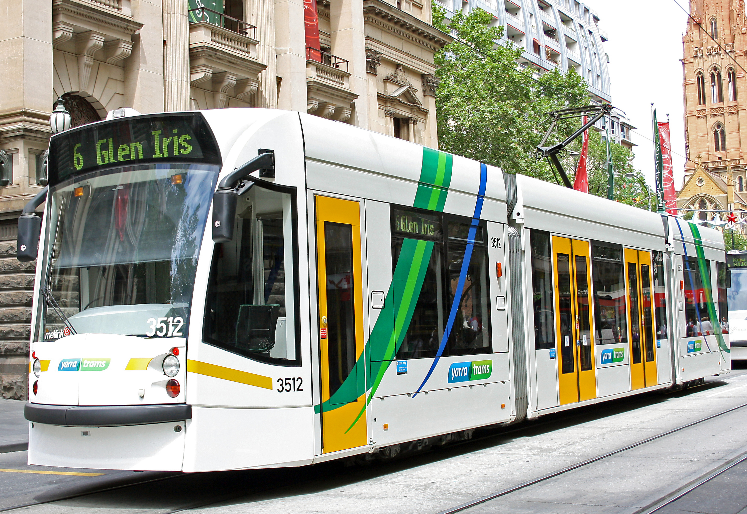
| | | | Melbourne My two nights in the Melbourne hotel were now over, and I hadn’t seen Melbourne yet, but not to worry. I knew I could see everything I was interested in in the center/centre in a day, and after Tasmania I could see another outlying destination, and it all worked out very satisfactorily. I got an early start, checked out, and left my bag at the hotel, and off I went. | | | | I will remind that Melbourne was founded in 1835 by settlers from Van Dieman’s Land (Tasmania), as was the state of Victoria. That pleases me, since Hobart is almost as old as Sydney and I’m glad to see that expansion came from there as well as from Sydney. Melbourne’s central business district (CBD) is delineated by the Hoddle Grid, laid out in 1837 by Robert Hoddle. It was established as a rectangle 1 mile EW by ½ mile NS (1.6 km x 0.8 km) to serve as the center city. Still, it’s different from Adelaide, since only the center was so planned, and today, outside the four delineating streets, early suburbs, now neighborhoods, established themselves with roads and street plans that were not necessarily parallel and perpendicular to each other, nor to the main grid. Thus north of La Trobe Street at the top of the grid is North Melbourne and Carlton; east of Spring Street in the east is Fitzroy; west of Spencer Street in the west is Southern Cross (Spencer Street) Station and the Docklands; south of Flinders Street in the south is the spectacular, gold-coloured Flinders Street Station of 1910, Australia’s oldest, and the Yarra River, across which is the neighborhood of Southbank, and beyond that, Saint Kilda and also Port Melbourne. | | | | Running NS through the grid are seven main streets, the fifth one over from Spencer being Swanston Street, the main street in town. What Hoddle did with the EW streets is interesting. He planned only three main ones, Collins, Bourke, and Lonsdale, with narrower, parallel service roads between them usually using the name “Little”. The “Little” ones are connected to the main ones by numerous lanes, giving the grid--and Melbourne--just that more character, which is sometimes called a laneway culture. Thus, up from Flinders Street is Flinders Lane (the exception to being “Little”) then Collins, Little Collins, Bourke, Little Bourke, Lonsdale, Little Lonsdale, before reaching La Trobe. But right from the beginning, the “Little” streets took on a personality of their own. Rather than serving as service roads, the cheaper real estate drew small businesses instead. Thus, the small, quiet Ibis Hotel is at the western end of Little Bourke Street, while most of the eastern end of Little Bourke is taken over by the colorful/colourful Chinatown. The Hoddle Grid, plus neighboring/neighbouring areas, gives Melbourne its charm and character. | | | | But when looking for charm and character let’s not discount the trams. While so many other cities worldwide tore up their tram lines in the 1950’s and 1960’s with gusto, and are now spending bundles to restore at least some of them, Melbourne kept its head, recognized them as a valuable asset, and retained them. Melbourne has one of the world’s great tram networks with 325 km (202 mi) of track and expanding, so that it’s now larger than ever. Trams encircle the Hoddle Grid, and cross it on their way to all suburbs.
| | | | Similar to Tokyo’s ring of rail stations around its CBD, with routes leaving the ring in all directions, Melbourne has its City Loop, perfectly adapted to the Hoddle Grid. Southern Cross Station on the west and Flinders Street Station on the south are just two of five stations on the City Loop, a partly underground, partly on trestles, railway that encircles the CBD, that is, the Hoddle Grid. There is one station on the narrow east side and two on the longer north. Arriving and departing suburban trains stop at all Loop stations.
| | | | The grid makes seeing Melbourne so pedestrian-friendly. From Ibis on Little Bourke it was just a short walk across the northern boundary of La Trobe into North Melbourne to the Queen Victoria Market, the type of establishment that many cities retain, but that others have downgraded or lost. I walked among the fruit stands, meat and fish, and what seemed like acres of clothing and souvenir stands. The QVM seemed like the perfect place to stop for a quick breakfast in the food court area--and was.
| | | | While Melbourne has added newer high-rises, it still retains 19C and early-20C heritage buildings. It was fun seeing the very Victorian, red-brick city baths, with separate entrances for men and women. Over near the NE grid corner was Saint Patrick’s (RC) cathedral, and on the outside of the Spring Street end of the grid was the Parliament building for Victoria, which had been the de facto national capital after confederation, but before the two Parliament Houses in Canberra were established. Across Spring Street from it were some formidable 19C hotels.
| | | | At the SE grid corner I went over into Fitzroy, first to the Treasury Gardens, which, on an island in a pond is an early monument to JFK. A little further along were the Fitzroy Gardens and Cook’s Cottage. To celebrate the centenary of the state of Victoria in 1934, the tiny 1755 English cottage that Captain Cook had been born in was brought over brick by brick and rebuilt here. I only saw it from the outside, and it was quite handsome. It can be billed as “the oldest building in Australia”, so to speak.
| | | | I then retraced my steps up Spring Street to narrow Little Bourke Street to walk the length of Chinatown, then turned south to see what Swanston Street looked like. At its intersection with Flinders, I visited the very attractive Saint Paul’s (Anglican) Cathedral, diagonally across from Flinders Station. Also at that intersection are the very modern buildings of Federation Square, where I stopped into the Ian Potter Centre, a newer museum for Australian art. As usual, I mostly avoided the very modern stuff, but found some beautiful 19C paintings of interiors of stately homes.
| | | | I thus completed everything I wanted to do by walking. I still had lots of time until I had to catch the evening ship to Tasmania, so I bought two Metcards, each of which covers all train, tram and bus travel. I bought the more expensive one for the day I got back from Tasmania for my suburban trip--always be prepared in advance--and the other one was a day card to make two trips right now.
| | | | I’d wanted to go, just for a very quick look, to the suburb of Saint Kilda, which is bohemian, a bit edgy, and has the largest concentration of restaurants and small shops in the Melbourne area. I got Tram 96 in Bourke Street, which turned south and was shortly in Saint Kilda. The tram showed me everything I wanted to see. It went down the main streets so I could get the atmosphere, and it went along the Esplanade with the view of the (gray) bay. My quick visit over, I returned to town.
| | | | [That was the sanitized version, so I’ll add something else that happened. When I got on the 96 it was crowded until it left Bourke Street, so I was standing. Seated nearby was an elderly gentleman of the type who give elderly people a bad name, so I’ll call him the Old Geezer. He was seated in an area of seats to be relinquished to seniors, and a young lady was sitting next to him. It is not true that odd balls inhabit only New York’s subways, since I found this one in Melbourne. He started expounding for all in earshot how college kids today are no good, even to their parents, and won’t even get up when they see an “elderly gentleman”. It turned out he was looking at me. What cheek! The young woman looked up to ask if I wanted to sit and I shook my head. I said, for all to hear, that I didn’t see any elderly gentlemen standing. That seemed to confound the Old Geezer just a bit, but then he declared “Well I’m 77 years old!!”, making that his Declaration of Entitlement. All well and good, but then I replied, with as sweet a smile as I could muster: “Well, I’M not.” He may have been well-intentioned, but someone should teach him that MYOB means Mind Your Own Business. End of story.]
| | | | On return from Saint Kilda I wanted to ride the City Circle Tram, and caught it right at the SW corner of the grid at Flinders and Spencer. (It’s a free tram, but I’d bought my day ticket to cover the other tram rides.) I was aware that the first part would be uninteresting, since I knew what the route was to be. Apparently, Melbourne wants to promote its new developments, so the circle that the tram makes goes first west of Spencer and the grid to show you the Docklands neighborhood. Behind the rail station is a new sports stadium, and new modern buildings next to Victoria Harbour. Fair enough, but then it was announced that we’d also be taking on a new addition to the New Quay. Instead of an elongated oval, picture an upside-down Q, with that tail being the extension. We were being shown “smart shops, restaurants, and bars” in the new development. I didn’t see any sign of human involvement, and anyway, I’d go to Saint Kilda for that sort of thing. In addition, we came to a dead-end and had to reverse. Back on the actual circle, it was nice to have a review of all the places I’d seen earlier on my walk. | | | | Then it was back to the Ibis to get my bag, and I used my Metcard to ride Tram 109 to Port Melbourne, a 12-minute ride. It was so simple to get to the ship this way. Off the tram, across the plaza, and onto the ship. Actually, there are two with the same name, with either I & II added, and I was on the Spirit of Tasmania I both going and returning. They were both built in 1998 in Finland. My cabin--I’d paid the 50% extra for sole use--was very comfortable, as expected. I had an excellent dinner in the upscale restaurant, ending with three Tasmanian cheeses accompanied by an excellent port. After dinner, I spoke to an officer and found out that the seas might get rougher once we were in Bass Strait. It turns out that it takes about two hours of slow travel, by regulation, before even leaving the very large bay that Melbourne’s on. That night it rocked a bit, but I didn’t find it bad. The 10 ½ hour trip covered 429 km (267 mi).
| | | | [At dinner, when I mentioned to the waitress where I was from, her first reaction was a breathless “Did you hear Oprah’s coming to Australia?!!!” Although I rarely have time to look at TV when traveling and writing, as it happens, I had heard the news on TV that Oprah Winfrey would be coming to Oz in a few months. I understand the importance for the tourism industry, which is why the program is being subsidized as it is. After all, there are still people who either don’t know where Australia is, or worse still, confuse it with Austria. Oprah will do at least two programs, maybe more, from the Sydney Opera House, which will be wryly referred to at the time as the Sydney “Oprah” House. Yet I still found it curious that the waitress was quite that enthralled with the news. Well, I say, if news like that stirs that much sugar into your tea, then good ON ya.]
| | | | Tasmania It was an early up-and-about as I disembarked in Tasmania for my long-weekend visit. Since passenger trains stopped running in Tasmania close to four decades ago, I’d pre-booked three bus rides with the Tassielink company, since that allowed dozing time in between, and worked out quite well. As I waited for the bus to arrive, I chatted with a security guard, who asked how the crossing had been. It turns out the two previous nights had been rough, and many got off seasick. He also commented that the two previous days there’d been snow, mostly in the mountains, yet some on the roads, but had been cleared early. Welcome to the chilly south!
| | | | [Just as Aussie is the national nickname for people and things, in Tasmania the corresponding word is Tassie, as in the name of the bus company, Tassielink. This is pronounced Tazzie, which makes some sense, since Tasmania is already pronounced Tazmania. On the other hand, since “Australia” does not have a Z sound, pronouncing Aussie close to Ozzie is particularly unusual.
| | | | And the insular rivalry continues. I spoke to Tassies that jokingly referred to the rest of Australia as “the North Island”, or “the Big Island”, while Tasmania was “the Main Island”. It reminded me of the New Zealander, in a country that does have its North Island and South Island, who said he liked to tease Aussies by calling Australia the West Island.]
| | | | But the sky was bright blue and the day was fine. On the beginning of the trip to Hobart I had a nice doze, until the break at Launceston. After Launceston I commented to the driver--I was in the front seat, and this particular day there were only three other passengers on the bus--how nice the sunny, green fields looked with the mountains on the left. There were sheep in the fields, and the wattle was just starting to come out this far south. The Midland Highway is also called a Heritage Highway, and had been totally convict-built. I remember reading that around 1850, the twice-weekly coach trip between Launceston and Hobart Town took 16 hours and ten changes of horses. This “coach” took 2h20. Close to arrival, I noticed that (the narrow-gauge) rail tracks were being upgraded, meaning at least freight was still a factor for rail, and heard that there’s some talk about bringing passenger rail back, but time will tell. Closer to Hobart the driver pointed out the snow on top of Mount Wellington, which hovers over Hobart.
| | | | Hobart The Derwent River drains the entire center of Tasmania and ends in a large estuary. Hobart is on the west side of this estuary, not far up from a large bay leading to the sea. Europeans settled Hobart in 1803, making it the second oldest city in Australia after Sydney (1788). I had a fifteen-minute walk across town from the bus terminal, during which I could already admire the many 19C and early 20C buildings, interspersed with newer structures. Parallel to the harbor/harbour and close to it is Macquaire Street, and I had booked a night there at the listed, heritage building called Macquarie House (1875). It was a delightful experience, living in a hotel that had been a period mansion. The location also provided quick access to Battery Point, a main goal of the walking tour I’d printed from the internet.
| | | | Salamanca Place is a street that edges the harbor/harbour, and that hosts each Saturday the Salamanca Market (note the typical stone warehouse), for which I was there on just the right day. Beyond that I walked to Battery Point, Hobart’s oldest precinct, with quaint streets, Georgian cottages, colonial mansions, and a village atmosphere. There were tiny houses surrounding Arthur’s Circus, and Watson’s cottages (1858) were four attached houses that had been built for workers. Around the edge of Battery Point and the harbour are sandstone warehouses that date from Hobart’s whaling days in the 1830’s, and heritage parks, including, up on a hill with views of the Derwent, Princes Park, which once had the gun batteries after which Battery point was named. A walk along Sullivan’s Cove then followed, which is the marina area of the harbour.
| | | | Back on Macquarie Street, I did a quick stop at the Tasmanian Museum & Art Gallery, which, as the name implies, has a little bit of everything displayed very well. There’s local art, a review of Australian money and the changeover in the 1960’s from pounds to dollars, and a large room about Antarctica, which is not all that far away from Tasmania in general and Hobart in particular. Of particular interest was the video of the thylacine. Although the exhibit just used the name “thylacine” (thy- rhymes with “why”) and studiously avoided the now disparaged name “Tasmanian tiger”, it was obvious what it was. The thylacine is not a feline, but a marsupial (pouch-carrier), and looks like a mid-sized dog with a very long tail. Stretching along its back from the shoulders to the base of its tail, but not including the tail, are stripes running partway down its flanks. These stripes are what got the name “tiger” started, which is inaccurate. Calling a thylacine a tiger because it has stripes is as inaccurate as calling a zebra a tiger for the same reason. As far as is known, unless an odd one is hiding somewhere in the wild, the thylacine was hunted to extinction, often by bounty hunters. A video of short films of thylacines from the 1930’s in zoos was pieced together on a loop, something like this one from YouTube, so you can watch and see how a now extinct animal looked. The last thylacine in captivity died in Hobart on 7 September 1936, and 7 September has now been declared National Threatened Species day. Once again, sic transit gloria mundi. | | | | Launceston The next day I spent writing in Macquarie House until the afternoon, when Tassielink took me back up to Launceston, arriving just after 5 in the afternoon. Launceston is third oldest: Sydney 1788, Hobart 1803, Launceston 1805. It was a charmed arrival. As I walked the 15 minutes to the hotel, it was a chilly, late Sunday afternoon with almost deserted streets, and the sun was just starting to go down and cast a golden light on all the mostly 19C historic buildings. I was already looking forward to the next day’s walk. | | | | We’d said that Launceston was named after a town in Cornwall. A bit of checking reveals that the Cornish town has actually significantly altered its name over time, but left the antiquated spelling. I understand the town’s name has actually shortened to either Lanston, or even shorter still to Lanson, but still spelled Launceston. However the Tassie town is pronounced as written, maintaining all three syllables, except that, following Aussie custom (Australia sounding like Ostralia), the first syllable doesn’t sound like “lawn” but like the name “Lon”.
| | | | Launceston is small, just a large town really, so it was hard to find guidance on what to look for. Fortunately, months ago online I found a website that quoted an article from the Sydney Morning Herald of 2 August 2004 which I printed out as a guide. In describing its “magnificent architecture” it stated that “Launceston . . . is really nothing more than a large country town with . . . a large number of elegant nineteenth century buildings. There is an argument that it has the greatest concentration of large nineteenth century buildings of any city in Australia.” Most intriguing was the advice that “The true enjoyment of Launceston is to take your time, linger at each building, and try and imagine what this remarkable city was like in the 1880’s and 1890’s”.
| | | | The interesting core of Launceston runs along three N-S street and maybe twice as many cross streets, so it’s easily covered at a slow pace. There are a few taller buildings, but no high-rises, so the city remains on a human scale. There is, however, one negative side, but it’s unavoidable, and happens in every city that has historic buildings. While the upper story/storey or two of a building is preserved, the street-level shop is “modernized”, which means essentially gutted and replaced with “plastic”. I describe as “plastic” the type of cheap overhang projecting from the historic building and shading the sidewalk, the overhang being in the same style as the cheap, newer shopfronts. | | | | But there was a plus side to this, whereby one could contrast the past and present. So many of the buildings, in the style of the time, had the name of the original establishment, and often its founding date, in stone on the upper level of the building, and I didn’t see one single original name above correspond to the current shop below. As is my custom, I took notes.
| | | | Where it proudly said above “The Beaumont Pharmacy” there was a pizzeria below. “W. Hart & Sons, Ironmongers” now housed a garden shop. Very dignified was “McKinlays, Est. 1886, Drapers, Furnishers, Tailors”, which now housed a shop with kids’ clothes. What a comedown. If the people who had commissioned their names on the façades only knew what would come of the buildings . . . .
| | | | “The Majestic - 1917”, either a cinema or theater, was now a men’s shop. The “Enfield Hotel” was a dress shop, and the very broad “Launceston Hotel” now housed three different shops at street level. One both admired the still-existing upper levels of these buildings and, given the current use, pondered the meaning of “written in stone”.
| | | | But another source had given me an address to look for that showed something special, “The Old Umbrella Shop”. It dated from around 1860, and was in mid-Victorian style. The street level had not been altered, and it now belonged to the National Trust, which used it, not really as a museum, but as its gift shop. As the lady pointed out, you could buy current umbrellas (and other items), from the one side of the shop, umbrellas, which, should they break, you just throw away, as we do today. But the building had been taken over in 1921 by R. Shott & Son, who made umbrellas and walking sticks--to last. If one of those quality umbrellas was damaged, you brought it in to be repaired. There were such antique umbrellas on display, including a very small one, which she explained was an umbrella hat meant for a horse. How all this moved one back in time! And the old cash register was still calibrated in pounds, shillings, and pence.
| | | | It was not all 19C; I found two streamlined Art Moderne buildings, one dated 1937, which looked as though they’d been imported from South Beach in Miami.
| | | | The Quadrant was an interesting experiment in street planning. Now the Quadrant Mall, the street is a quarter-circle that connects a main N-S street with a main E-W one. Nearby, a current hotel that had been a coaching inn had on its lawn three milestones showing the distance to Hobart Town (which was an early version of the name, along with Hobarton). There was the colonial synagog of 1844 that was characterized by an Egyptian revival façade typical of the architecture of the time. The grand Victorian style of the Post Office was evident by its red brick and tower. Across the street was the Town Hall. It’s a fine building, but in Classical style. Actually, the building at the right on the corner is more typical of the style of the buildings in town.
| | | | Down the street was the gold and ochre Cornwall Hotel (as it said in stone above), renamed in 1981 the Batman-Fawkner Inn. As the Herald said, “It was here that John Batman and his friends met and decided to cross Bass Strait and establish the new colony which would eventually become Melbourne.” John Batman wanted to name the city Batmania, which would bring more than a few smiles today. I wonder who talked him out of it. It was John Fawkner who, in 1835, financed the settlement of Melbourne. In the lobby of the hotel was a very large plaque put up in 1934 commemorating the centenary of the founding of Melbourne in 1834, which stated quite directly: “A meeting held here resulted in the founding of the city of Melbourne”.
| | | | A bit further south is Princes Square, a park covering an entire block. The Herald says “Princes Square [is] surely the finest and most impressive of all the city’s squares. It is notable for its fountain and handsome Georgian and Victorian buildings.” There were flower beds with flowers in full bloom, just a bit surprising given the bit of chill still in the air on this sunny day. The park, great for sitting, is surrounded by three church steeples and the very French-looking fountain in its center is decorated with classical figures and cherubs. The fountain has two levels of basins and empties into a large pool. The Herald says that “ . . . the fountain, [which was] purchased from the Paris Exhibition of 1858, had to be changed because the locals objected to the half-naked nymph - she was replaced by a pineapple.” It’s true, but not a squat pineapple itself, just the pointed fronds on top.
| | | | Everyone says that you must see Cataract Gorge, and, since it’s just a few minutes’ walk from the west edge of town, I decided to try it as my last item of the day. But the visit had a pleasant turn that is of interest. When I reached the point where the river came out of the gorge, I didn’t cross over the bridge, but turned onto the path on the south side of the river, where I was. It immediately started going up a lot of steps, which were uneven and hard to negotiate. After I’d climbed the equivalent of several stories high, I saw at a viewpoint that there was a flat, low-level path on the other side. If I’d only crossed the bridge in the first place! Just then, coming down the hill was a couple, and they confirmed what I’d finally figured out--I should have gone on the other side. I must have looked winded, since Danny offered me some water, and I turned back to the start, which is where they were going, and we had a nice chat. We all then went up the north path down the gorge, which was attractive, but, after a while, pretty gorges are pretty gorges, high cliffs are high cliffs, and so on. At the inner end there was a suspension bridge across the water back to the south side that was a little wobbly, but nothing like the one in Thailand at the elephant camp had been. At the end, Danny offered to drive me back across town to my hotel. The memory of this part of the day will be the nice people I met rather than the gorge itself.
| | | | The 1h10 Tassielink ride back to the ship was also memorable. The bus was much smaller than earlier, and I sat up front near the driver, on the other side of his large console (remember, since you may be picturing it wrong, this being Australia, he was on the right of the console and I was on the left). Behind him was an elderly woman, a retired teacher, who apparently takes the trip frequently to and from her home in Devonport, since she’d gotten to know the driver. There was one other person further back, but the three of us up front had a most enjoyable conversation as we watched the sun setting. He dropped me (just me!) in East Devonport right at the terminal for the Spirit of Tasmania (Spirit I, again). All in all, most passengers brought their cars with them, but I was surprised that so few crossed as foot passengers (a school group had, on the trip over). And so I left Tasmania.
| | | | Statistics I maintain a lifelong record of sea (and river) voyages, counting any overnight trip in a cabin from one to (so far) seven weeks (around South America) Sailing on the Paul Gauguin in Tahiti last year was voyage #46, so the two Spirit of Tasmania sailings are voyages #47 and #48.
| | | | The Travelers Century Club counts destinations, not countries. Its criteria include separate legal jurisdictions (so both England, Scotland, and others are counted separately within the UK), and also major, well-populated islands, such as Corsica as well as France, Sicily as well as Italy, Hawaii as well as mainland US. Thus, mainland Australia is for me destination #130, and Tasmania #131. This makes to me great sense, since few people who visit mainland Australia get to Tasmania. | | | |
| |
|
|
|

