|
Reflections 2010
Series 20
September 11
RTW2 VII: Cairns - Uluru/Kata Tjuta - Darwin
| | I am so enthralled being in this country. I actually did wake up this morning here in Cairns and wondered--was I in Canada? Maybe New Zealand? No, it was Oz. I see a real affinity and similarity between these places and the US. It is wholly separate for my interest in Europe, including the UK, which bubbles just as fervently, but on a different burner. | | | | I just got a pleasant note from Carter Brey (2008/5). He’s performed here on several trips in a number of cities, and confirms that the acoustics in the Concert Hall in the Sydney Opera House are wonderful. While I didn’t attend any performance there, I have to say that I absorb places, both urban and non-urban, perhaps differently than others. When I see the Opera House I see it as an urban space, its history, the dissention with Utzon, the reconciliation and reconstruction of the interiors according to his original design. I see it as a world icon, one that's developed incredibly rapidly.
| | | | These places blend together also in tragedy. When I was in New Zealand a year ago January, in Wellington and Christchurch I watched on TV the Australian news of the bushfires in Victoria. Now in Australia, here in Cairns, I watch on TV the New Zealand news of the earthquake that struck right in the historic center of Christchurch, my favorite New Zealand city. I hope they can restore and repair as much as possible, but it’ll take a long time.
| | | | Cairns After the arrival of the Sunlander in Cairns, I walked the several blocks to the marina area where my hotel was, but via the Esplanade, an attractive boardwalk and park area along the seaside. Cairns has two World Heritage Sites side by side, one in the sea, the Great Barrier Reef, and one in the mountains, the Daintree Rainforest. I knew the reef trip left from the marina, and the Kuranda train trip left from back at Cairns Central, so I was well-positioned for both.
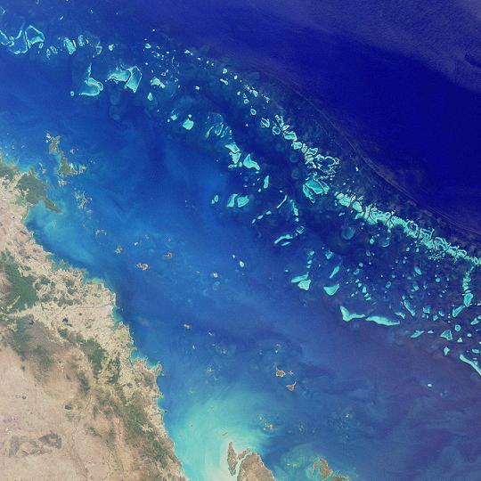
| | | | Great Barrier Reef The Great Barrier Reef is the largest coral reef system on earth. It’s the only living thing on earth visible from the moon, or, phrased differently, it can be seen from outer space as the world’s biggest single structure made of living organisms. The Outer Reef is actually a network of reefs. It consists of some 2900 individual reefs and 900 islands, with the continental shelf on its outer edge. It runs from just north of Brisbane up the east coast of Australia to Papua New Guinea. It’s bigger than the UK, being over 2600 km (1600 mi) long. It’s 24 km (15 mi) wide in its northern reaches and 240 km (149 mi) wide towards the south.
| | | | I’d booked a catamaran trip out to the reef and was quite happy with the trip. It was some 60 km (37 mi) all the way out to the Outer Reef, with a stop on the way at Green Island . Now a tiny island with trees might not seem to be remarkable, but Green Island is a coral cay, and any islands are highly unusual in the reef, since most of the reef is submerged. But Green Island is particularly unusual, since it’s the only island in the entire reef that has a tropical rainforest on it. Our cat stopped here to drop off local visitors, and pick up others who wanted to go out to the Outer Reef as well. You’d think the name of the island would be clear, given the forest, but it was named by Captain Cook in 1770, either quite obviously because of the lush vegetation, or perhaps after Charles Green, who was the astronomer on board the Endeavour. Both explanations are likely, but no one really knows.
| | | | It was an hour from Cairns east to Green Island, and then about another hour north from there to the very large pontoon the company maintains off Norman Reef. The outbound trip was broken up by the serving of cake, and the return trip by cheese and crackers/biscuits. A rather good cafeteria-style lunch was served on board the pontoon, and you could eat back on the cat with its air-conditioning, or on the undercover seating of picnic tables on the pontoon, where we stayed three hours.
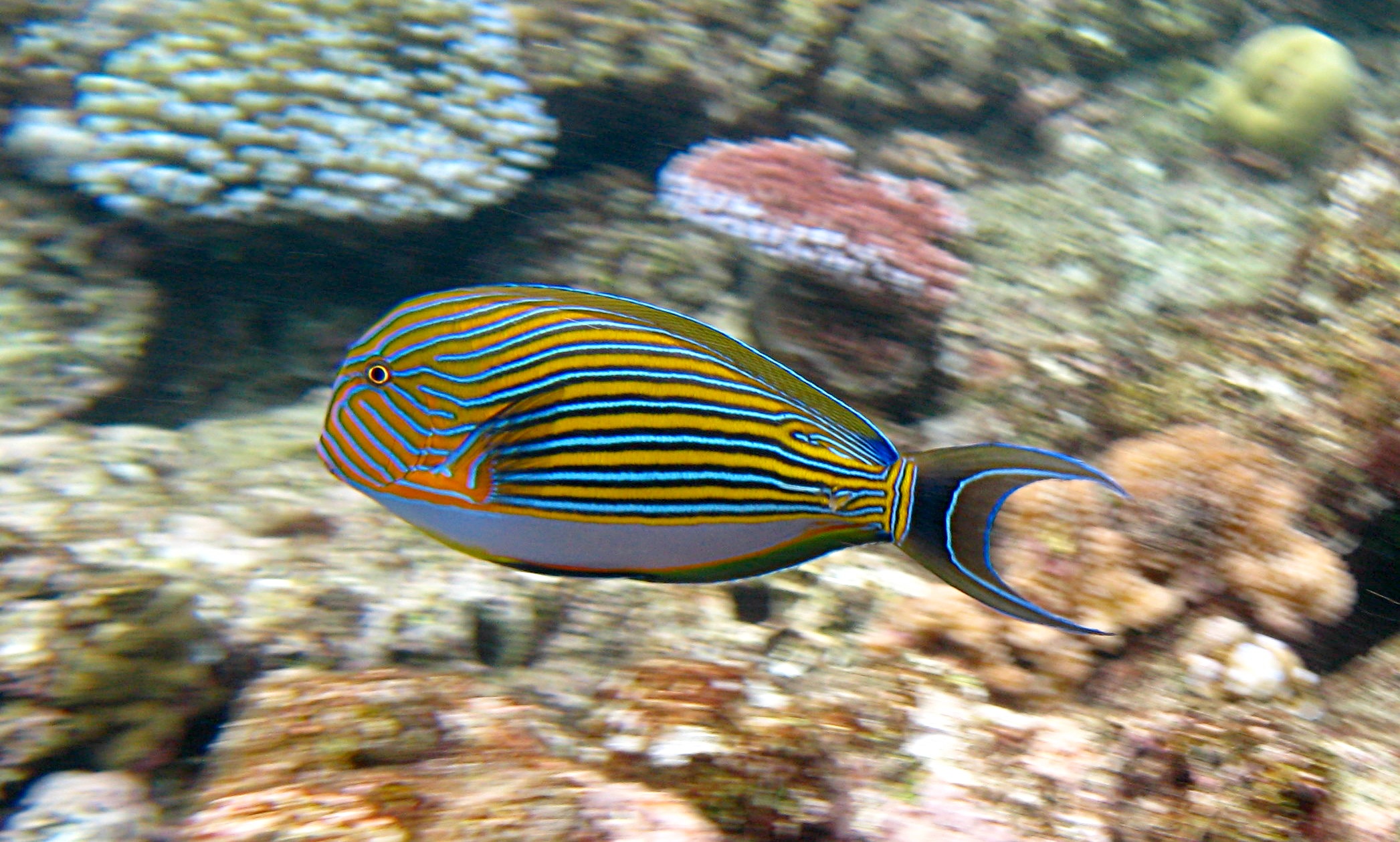
| | | | Many, but far from all, visitors went snorkeling and scuba diving off the pontoon, but I, and many others, found much more attractive the semisub (semisubmersible) that would take you around on half-hour trips off the pontoon. It was very different from the semisub I’d taken in Bora Bora (2009/16). There, we went out to a small pontoon, and climbed down a real sub hatch. There were only six passengers, and the semisub was let down on cables. We saw a lot of fish, and a bit of reef as we went down. It was the depth that satisfied me, since we reached 33 m (108 ft). The semisub at Norman Reef was totally different. It was very large, and totally self-propelled. It didn’t have a hatch, but regular entrance on the upper level, after which you went down to the lower level on one of two staircases. The lower level was one huge bench, with windows all around the very large cigar-shaped sub. We went horizontally, not vertically, and never achieved any depth whatsoever, with the water surface always seemingly at arm’s length. However, we saw considerable fish, such as this striped surgeonfish, but the absolute best was the coral. It just doesn’t get better than this. Given the height of the reef, close to the surface, we were over and next to the most unbelievable variety of huge corals, some dome-like, some tree-like. It was such a good viewing experience that a number of us, including myself, did it a second time before leaving the pontoon for the day.
| | | | There is the possibility of a helicopter coming out to the pontoon (there’s a separate floating helipad reachable by a dingy), and I’d signed up months ago, but they told me right away they needed many signups to make it worthwhile, and it never happened. Still, as I was talking to a lifeguard on the pontoon, I realized how clear the water is. What I had considered to be algae floating on the water with white spaces in between, was simply the coral I was seeing underwater, with white sand in between. All in all, it was a most enjoyable learning experience.
| | | | [Some side comments: Given that Cairns is so far north, tropical, and closer to Asia, there were many Japanese visitors, maybe a quarter of the passengers. There was Japanese staff and brochures to accommodate them, including Japanese scuba diver staff. A pleasant side affect of all this is that the (Hilton) hotel buffet breakfast included the wonderful miso soup I’d become addicted to in Japan last November. I’m convinced that no breakfast anywhere should start out with anything other than a hot bowl of miso soup. Talking about eating, I’ve several times gotten hold of ANZAC biscuits while in Australia, something else without which I do believe I cannot survive. And finally, I’ve gotten quite used to being called “mate”, although it’s frequently pronounced “mite”. Not everyone uses it, but when used it does seem to be a “guy thing”. Got that, mates?]
| | | | Daintree Rainforest The Daintree Rainforest is a tropical rainforest. It’s the oldest one in the world, estimated at 100-135 million years old. It’s the largest continuous rainforest on the Australian mainland. Within the rainforest is the town of Kuranda, which is most interestingly accessed via the Kuranda Scenic Railway of 1891, no longer used for regular commuter service. There is also a “Skyrail” Cableway (1995), which I will use to return from Kuranda. On this map the railway is to the left of the Barron River and Gorge (a National Park) and the cableway to the right.
| | | | To see the rainforest, I was primarily interested in the railway, with only a minor interest in the cableway, and one could have taken a round trip on either, or mixed and matched either way. I was glad I mixed and matched, with the railway first, and it turned out I was pleased with the cableway after all, not as much for the ride (if you’ve done one, you’ve done ‘em all) as for the additional access to the rainforest. Kuranda, on the other hand, which likes to call itself the “village in the rainforest”, can in my opinion be skipped.
| | | | Kuranda Scenic Railway The Kuranda Scenic Railway rises 328 m (1076 ft) on its 34 km (21 mi) route through 15 tunnels from Cairns to Kuranda. I elected long in advance to go Gold Class, which I find always to be a good move on historic rail trips. The regular cars had padded benches, and were certainly adequate, but the Gold Class coach had easy chairs and deep-red mahogany paneling all around. The curved ceiling was, curiously, an embossed “tin” ceiling popular in buildings a century ago. The ensemble had a period charm. There were only six others on the coach, four of whom were unfortunately a bit loud, but it was still enjoyable. The attendant served complementary drinks, and I took mimosas. There were then warm hors d’oeuvres, and then every few minutes more and more pastries came out. It took 1h45 to get to Kuranda, including a stop close to the end at Barron River Falls and Gorge, where we all got out to see the view. At that point, the cableway was visible on the other side of the gorge. This is pretty much how the trip looked on the Kuranda Scenic Railway.
| | | | | | 0:03 Cairns Central
0:07 Inside a regular coach
0:47 Barron Falls
1:20 Getting out at Barron Falls Gorge
1:38 Skyrail across gorge
|
| | | | Skyrail Cableway In Kuranda, where the two stations are adjacent, a shuttle bus was available to take you to the far end of the main street, making for an easy stroll back. Although there were some nice banyan trees along the main street, there was no charm to the town that seemed exclusively given over to shopping and eating stalls. The railway, who had sold me the tickets online, had allowed four hours (!!!) there, and I would have gone out of my mind. I went back to the cableway, which descends 7.5 km (4.5 mi), and makes two stops on the way to its lower station, where a bus connects back to Cairns. The buses run only every two hours, but I arranged for one that was two hours earlier than had been planned, still giving me plenty of time to pass on the ride down. | | | | The cableway is in three sections, making for two transfer points. Business seemed slow, and on each section I was alone on each six-seater gondola, hovering high above the rainforest. I was able to make good use of the boardwalk trails at the two intermediate stations. Both trails explained about the rainforest, but the first one brought you right to the edge of Barron Gorge to see the falls. At that point, the station the train had stopped to see the falls was visible across the gorge.
| | | | I still had over an hour to kill at the lower station waiting for the bus, and I visited the gift shop. It was indicative of where I was that the animals in the kiddie books were called Wally Wombat and Ken the Kangaroo, and that there were small stuffed kangaroo and koala dolls, even a large stuffed wombat doll. But I was then delighted to see a life-size echidna doll, in all its frosted-spike glory, and directly next to it--you guessed it--was a stuffed, furry platypus doll, complete with leatherette snout and feet.
| | | | Uluru/Kata Tjuta First, some background. In the lower part of the Northern Territory, in the area of Australia referred to as the Red Centre, is Uluru-Kata Tjuta National Park, a World Heritage Site. Ownership of the two rock formations was returned in recent decades to the native populations, always referred to as the “traditional owners”, who hold them sacred, and the original names were semi-restored. Uluru (u.lu.RU, or, if you need it this way, oo.loo.ROO) had been renamed Ayers Rock by Western settlers (2010/12) and the largest formation in Kata Tjuta (JU.ta) had been renamed Mount Olga, and by extension all the formations in Kata Tjuta were called The Olgas. Upon restoration, dual names were maintained for each, with the English first. Eventually, though, the native populations petitioned to put the original names first, so that today they are Uluru/Ayers Rock and Kata Tjuta/The Olgas. Note that the park name uses only the original names, which I will as well, although Qantas welcomed us to Ayers Rock, and the hotel complex continues to be named Ayers Rock Resort. [The situation is similar with the tallest mountain in North America, in Alaska, whose name went from Denali to Mount McKinley then back to Denali, including as the name of Denali National Park. Denali is not dually named.]
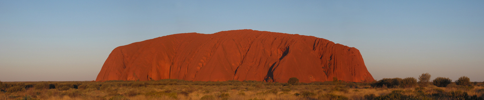
| | | | Uluru Uluru is a sandstone monolith (literally “single stone”, but implying large size) which has become the premier natural icon of Australia just as the Sydney Opera House has become the premier man-made icon. It’s 9.4 km (5.8 mi) in circumference, but 2/3 is thought to be underground. It apparently appears to change color/colour between pink and deep wine red as different light strikes it at different times of the day and year, and sunset is particularly remarkable when it briefly glows red. The rock is dappled, not smooth or even as it might appear from a distance. It resulted from sediments laid down 600-700 million years ago in an inland sea, then thrust 348 m (1141 ft) above ground by geological forces. It rises to 863 m (2831 ft) above sea level, which is significant, since most of its bulk is below ground. It has many springs, folds, overhangs, waterholes, caves, and rock paintings, and is sacred to the local aboriginal people, the Anangu.
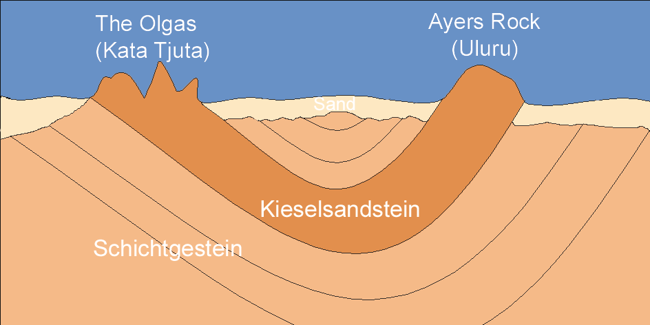
| | | | Kata Tjuta Kata Tjuta, which means “many heads”, consists of 36 immense steep-sided ochre rock domes, higher than Uluru. It lies one half-hour to the west within the park. Curiously--and I’m sure, few visitors realize this--they’re two ends of the same formation, as can be seen in this geologic cross-section, once again in German.
| | | | Schichtgestein, literally “layered stone” is just layered sedimentary rock, put down over the millennia. Kieselsandsstein, which is now called Quarzsandstein, is quartz(-based) sandstone, and is what the two formations, linked together underground, consist of, surrounded on the surface by sand. All these layers have been bent through natural forces, so that, as a park guide pointed out to me at Uluru, the layers of sandstone at Uluru are almost vertical. Because of that, the east side of Uluru is older than the west side, since it consists of lower layers of the sandstone, and the reverse is true at Kata Tjuta.
| | | | The most interesting single fact I learned while at Uluru is why we see what we do of it, and as much as we do of it. One would think that Uluru and Kata Tjuta were thrust up above the surrounding plains, but quite counterintuitively, about 300 million years ago, just the reverse happened. The surrounding plains were gradually eroded away, exposing as much of Uluru and Kata Tjuta as we see. It’s a little like nature carved a statue by removing outer layers and revealing what was underneath all along.
| | | | Except for the couple of things I just said I learned while there, all the above is advance research. My own experience began on the 2h50 flight from Cairns, diagonally from the northern east coast to the mid-center of the country. I was again almost as far south here in the centre as Brisbane is on the east coast. Cairns had been quite warm and humid, but bearable, and, even though we were further south now, I expected desert heat. Maybe that happens in the summer, but the temperatures and humidity I found in Uluru/Ayres Rock were pleasant, if not sublime, sometimes jacket weather, sometimes shirtsleeves. The humidity was so low (40% one day, 20-30% another), that anything wet dried right away, including shirts rinsed out in the hotel sink. Of course the altitude made a difference, too. The area, at least at this time of the year, reminded me of New Mexico (2007/14). | | | | As the plane approached on a very sunny and clear day, you could see the very red earth of the Red Centre below, interspersed with green shrubs and grass patches, and in the middle sat Uluru, standing out on the plain. The “big pebble” looked like a giant, red Easter egg sliced lengthwise and lying on its side on a large, flat table.
| | | | I had rented a car. It turned out to be a very wise decision, especially when one is confronted with bus tours at dawn and sunset to Uluru, the same again to Kata Tjuta, and more and more of this and that. The only tour I did book was the Camel Sunset (more later). Of course, this being Australia, the car was steering wheel-right, drive-left. And it worked like a charm.
| | | | I’m still surprised at that South African guy I met in Provincetown (2009/28) who refused to rent a US car with steering wheel left-drive right. One adapts, as long as the odds aren’t too great. What I mean by that is that I did have my troubles in the UK that last time (2001/2) but I now see my mistake. The only car available then was a stick-shift, which I can handle, but adapting a stick shift to the other side is doing too much at once, and should be avoided. This time I had a nice little compact automatic car, and shifting from Park to Drive to Reverse with your left hand is no problem, not like playing around with a stick shift with the “wrong” hand. Other than that, you simply drive on the left. The only possible problem is when turning, either way, since on the side road you may revert to old habit, so the first day, when turning, I just chanted the mantra “left, left, left”, and had no trouble. One minor problem is the turn signal, which is on the opposite side. That first day I turned on the windshield wiper a couple of times until I remembered where the turn signal was. And on the turn signal, left is up, not down. Once that was settled, the three days of driving on the left was a piece o’ cake.
| | | | In the 1970’s the situation at Uluru was chaotic. Motels had sprung up around the rock (now eradicated without a trace) and the site was not treated with sufficient respect. That’s when the national park was established on an axis from west (Kata Tjuta) to east (Uluru). Just north of the park boundary at the Uluru end a Northern Territory township called Yulara was established, and a uniform hotel operation was established there, with a small airport just to the north. Although the hotel is still called Ayers Rock Resort, all signs in and around the park direct you to Yulara. Therefore, in my humble opinion, Ayers Rock Resort’s name should be updated, not to Uluru Resort, but to the very sensible Yulara Resort. I’m waiting to see if that ever happens.
| | | | Although the hotels are a bit pricey, the complex fits extremely well into the environment, and it was an enjoyable stay. The main road coming from far-away Alice Springs (462 km [286 mi]) is joined by the airport road, and then by the loop road for the hotel complex, before the road continues to the park. All budgets are accommodated. On the south side of the loop is the campground and mobile-home area, then the (Mobil) petrol station, and then the dormitories for the backpackers. The camel farm for the camel tours is also there. On the north side are four hotels (plus shops and restaurants, plus a supermarket) at varying, rather high prices. I chose the least-pricey Lost Camel Hotel, and Stella Bugg at Qantas got me an even better price. It was all in earth-tones, and had a swimming pool, but it was just the simple charm of the desert area that made it a pleasure.
| | | | Once unpacked, I still had half a day, plus the flexibility of my own car, so off I went. On the main road again, the park entrance was another ten minutes south, where you had to pay a park fee covering up to three days of park visits. Then the road split right to Kata Tjuta, and straight for the Uluru sunset viewing areas alongside the main road (one for buses, one for cars). Beyond that, since it was still early, with a 6:35 sunset, I took the circular road around Uluru, which hugs it on three sides. The former part of the road on the south side has been removed, and replaced with one that loops further south for a more distant view from that direction, plus a new dawn viewing area in the south. At this point I felt myself well oriented from all directions, and went back to the car sunset viewing area to look at Uluru. | | | | The footprint of the mountain (OK, rock) is diamond-shaped, roughly pointing in the four cardinal directions, but with the eastern point lengthened. That means it has longer NE and SE flanks (dawn viewing is from the SE) and shorter SW and NW flanks (sunset viewing, the iconic view of Uluru, is from the NW, which is what this picture shows). The grass I saw was deeper green than this picture shows, and as the sun went down, there were changes in the redness of the rock, but on that particular day, it never got as prettily red as this picture shows.
| | | | Now let me speak frankly. Don’t get me wrong, I loved Uluru, and rank Sydney and Uluru as the two top places I’ve seen here so far. Keeping that in mind, let me say that the sunset-sunrise things are usually more hype than fact. I’ve seen the postcards that show Uluru glowing in shades of red, pink, brown, even gold. But, actually seeing that is just like the probability of seeing the Matterhorn without clouds obscuring it. Experiencing Uluru one appreciates the spirit of the place. It’s magnificent, immense, overwhelming, mysterious. Other mountains may be larger, but lack the spiritual jolt. But one should merely hope, nothing more, to experience just a bit of color change in it at sunset or dawn. See what you think of this video of an Uluru sunset, with 30 minutes condensed to 75 seconds. It’s impressive to see such a large mass reacting to the light changes, you do see a variety of browns, but don’t expect a variety of color changes unless you come every day for a longer period of time. In my experience, although the sky was clear, there were a few clouds on the horizon around the sun, so they cast a shadow on Uluru at the end. But still it was nice to do.
| | | | Now to contradict myself, here’s a promotional video put out by the Northern Territory. In these selected shots, you’ll see more of the spectacular things you expect, including the red earth and greenness of the shrubbery.
| | | | My middle day turned out to be much longer than planned, and quite a bit of fun. I’d wondered if I’d “do dawn”, but then decided to get a 5 AM wakeup call to catch a 6:53 sunrise. I picked up a take-away muffin and cappuccino in the lobby of the Lost Camel and stepped outside into the pitch blackness of the outback desert. After I moment my eyes adjusted to the dark and I found my way to the parking lot, and even at that time of the morning I was able to drive on the left (!!). Fortunately, given the number of dawn and dusk events here, the very modern road had reflectors on low posts on either side so you could find your way. But still my thoughts were: Me? At dawn? In the Outback? In Australia? In the antipodes? I was among the Fools of Dawn looking for an Uluru sunrise.
| | | | One of the best times of the day happened while I was still on the entry road, still near the sunset parking area. The eastern sky got a battleship-gray tinge, which then outlined the black silhouette of Uluru! What an amazing shock to see the black mass sitting there in the darkness!
| | | | The sunrise parking lot accommodated far more than the number of cars that showed up, so I knew it was a (pleasantly) slow time of the year. I trudged up the wooden boardwalk to the platform viewing area, found a bench and munched on my muffin and lukewarm coffee, since nothing was happening yet, then went to the front of the platform. The sky was semi-cloudy, and once again shadows affected the “show”, which never looked quite like this orange Uluru Sunrise.
| | | | The sun and clouds were playing games, but it all worked out. Does it ever bother you when people walk out too early at the end of a movie? Well, sometimes they miss something good, and that’s what happened here. Given the effort to get there, I was not in a hurry to leave, but by a half-hour after sunrise, most of the people had gone. Then, with Uluru still in vague shadows, in the distance, 32 km (20 mi) to the west as the crow flies, the domes of Kata Tjuta lit up like a bunch of light bulbs as a large patch of sunlight hit them. It balanced out the dawn view we didn’t see too well at Uluru.
| | | | My plan for the day had been to do two small walks at Uluru, then go back to rest, and, in the afternoon, to drive out to Kata Tjuta, which is 55 km (31 mi) by road. But things fell together in such a way that I wasn’t back at the hotel until almost sunset.
| | | | I first drove up to Uluru to do the Kuniya Walk on the SE (dawn) face, a short distance in from a parking lot. The clouds were thickening and it even thundered once, but everyone plodded on. There were wide caves in the surface of Uluru caused by wind erosion, so that the interior of the cave had the appearance of a wave. On the ceiling were paintings, which were not artistic, but instructional, for the men to teach the boys. Two symbols were explained and made perfect sense. What looked like the concentric rings of a bullseye represented a waterhole, essential to survival, with perhaps a pebble dropped in the center to cause ripples. What looked like a U, pointing in any direction represented a sitting person (sit in the sand sometime and see what sort of impression you leave). Thus a series of U’s around a bullseye represented people sitting around a waterhole. At the end of the walk was the waterhole itself, of which there are about five around Uluru, perhaps two meters/yards deep. They’ve always been essential for survival. There was even a trickle of water coming down the sheer, red sides of Uluru from the top.
| | | | The Anangu have numerous creation theories, and many remain their secret. The simplest ones they do tell to outsiders. These are the ones that would be told to a little child, and the feeling is that outsiders can handle that type. This is called the Kuniya Walk since Kuniya was a kind of python that fought Liru, a kind of poisonous snake, supposedly right near that waterhole. Every hole, cleft, and boulder supports the theories. This hole was made when one of them threw a spear, that boulder is the remains of someone. In other words, the landscape is used to confirm the mythology.
| | | | I then drove again around Uluru to the NW (sunset) face to do the Mala Walk, which is longer and has more to see. Just as I got there, the (first) downpour came, and I put back the car seat and dozed about 10 minutes. When it was over, by chance the Ranger-Guided Mala Walk was just starting right there, which is only done once a day, so I joined it, and it was a high point of the day.
| | | | The ranger explained that the mala was a small wallaby, called a hare-wallaby. It is no longer in this area, and still cannot be introduced, as the park wishes to do, because of introduced predators. What predators? Feral cats, house cats that have gone back into the wild. They seem to like malas, and until they can be controlled (here in the middle of the Outback?) no malas will be reintroduced to the area of Mala Walk.
| | | | We were right near the climbing area, which I was glad to see had the sign “Climb closed due to strong winds at summit”. People (“idiots”) have long enjoyed climbing Uluru (it must be testosterone-related), and there is one flank where it’s possible to do so by holding on to a chain that goes up a steep slope. The Anangu have long requested that no one climb Uluru, not only because it’s a sacred site to them, but also because they feel they owe it to visitors to keep them safe. 35 people have died climbing on the mountain and the ranger used this analogy. How would you feel if someone at your barbecue drowned in your pool? Their family would always associate your house with death, and that’s another thing the Anangu want to avoid with Uluru. In addition, the ranger pointed out that climbers use the top as a toilet, and the waterholes at the base are no longer safe for drinking. He also said that legislation is at hand that will forbid climbing, but not until 2020. | | | | There are still sacred sites around Uluru, some for men, and some for women, and visitors are forbidden to enter or even photograph them. One we passed was a women’s site, which had a triangular cave above it that apparently was to remind one of a mala’s kangaroo-like pouch. Given that, this site was a traditional birthing site for Anangu women, which men were forbidden to enter, and the general public still is.
| | | | The walk went on for some time, and the rains came again. Some people scattered, but many of us just got wet and kept on walking and listening to the stories. I had bought a floppy fisherman’s-type had for this trip to avoid sun (and I suppose rain), and I had my jacket with a hood. However, I was wearing shorts and sandals, and the sandals became soaked and muddy. Still, onward.
| | | | When we stepped into some of the long, horizontal caves, we had to dash through the “waterfall” of water coming down over the opening, because Uluru had not only a number of thin waterfalls coming down, it had just large sheer areas of water coming down the side, like when a bathtub overflows. Apparently there are lakes at the top that are very full, so a little rain makes them overflow like bathtubs. That’s when we learned it was worthwhile getting wet. The ranger had been in the park for a year and had never seen water come down Uluru, so he started taking his own pictures. He said there are 350,000 visitors to Uluru annually, and about 2% get to see water coming off it, so we were very lucky. And at the end of the walk, a thick waterfall was flowing right into a good-sized waterhole. | | | | It’s possible to do the Uluru Base Walk, which means walking entirely around Uluru in about 3.5 hours. While, as we said, Uluru is 9.4 km (5.8 mi) in circumference, the base walk is a larger loop, and comes to 10.6 km (6.6 mi). At first I thought I might try it, if not that day, maybe the next when I had more time, but given the weather, and given the fact that the Mala Walk, which is part of the Base Walk, is already about 1/6 of it, and I’d also walked a bit in both directions earlier on either side of the Kuniya Walk, I passed on doing the Base Walk. Instead, I went to the Cultural Centre, where I washed my sandals and feet. Given the low humidity, all clothes were already dry, and the sandals dried in no time.
| | | | Two things at the Cultural Centre: the ranger had drawn three lines in the sand with his shoe. Two lines formed a right angle, and a longer line bisected it. He asked what direction you would go in if you saw that. Western eyes saw an arrow, and you would go in the direction the arrow was pointing. But the ranger pointed out that Anangu eyes saw a (three-toed) emu’s foot, and would walk in the direction of the emu. There’s cultural differences for you. In the tiled floors of the Centre there were emu-foot tiles telling you what direction to continue in, and I always felt I was going backwards.
| | | | Also at the Centre was a Sorry Book, which was very impressive. What would you think a Sorry Book could be? As in any national park, it’s strictly forbidden to collect any sort of samples at Uluru, compounded by the fact that the site holds sacred status. The Sorry Book contained real letters that accompanied items returned to the park, usually due to guilty consciences. Someone took some sand, and sent it back. A man said that as a 15-year old he took some rocks, and now, years later, he decided it was foolish and sent them back. It was really quite moving to observe human nature in this way.
| | | | Not wanting to go back to the hotel at this point, but with clouds still coming, I sat in the car reading my novel until blue sky broke through, then drove off west to Kata Tjuta, which you can view from two sides, the south and the west. In the south there’s the Dune Viewing Walk of about ten minutes, which gets you pretty much this view. Nice to see some domes, but let’s be frank again. People come from all around the world to see Uluru. It Uluru didn’t exist, no one would come to the middle of nowhere just to see Kata Tjuta. And again, by the time I got there, they were in the shade again, but amazingly, looking to the east, Uluru was in bright sunlight, and was the exact compliment to what had happened right after dawn. That was enjoyable.
| | | | Moving to the west (sunset) side, the view of Kata Tjuta gets a little more interesting. This more frequently-seen view reminds me of four fingers folded at the knuckles. There are some more strenuous hikes in the valleys in between. Still, even if it weren’t in the shade, I wouldn’t have stayed another hour for the sunset, since my very long day had started before dawn.
| | | | My third and final day was much more relaxed, and I did some writing. The sun came out by the afternoon, and I took my helicopter flight to Uluru, which is flight #6 for me after the last one in Bora Bora (2009/16). A van picked up some eight people, and we went up in three trips. The copter was smaller, and held two in the back, and one to the left of the pilot (me, with a bird’s-eye view forward). The description had said we’d overfly the resort first, and this is pretty much how it looked. Facing south (Uluru would be forward to the left) the hotels line up in the foreground, with the Lost Camel being the reddish complex just to the left of that large, gray, protruding parking lot. We then flew up to Uluru, and, staying on the one side, flew to the left, then to the right, before returning. This picture is also a helicopter view. It’s a wide-angle view, so move it left to right. Notice the top surface of the mountain.
| | | | That’s the sanitized version of the flight. In reality, it was the most boring flight I’ve taken (the first, Victoria Falls [2008/11], was the best). I should have read the route better, because I’d assumed that, if we couldn’t perhaps overfly Uluru, we’d at least circumnavigate it. Actually, the view of the top of it is much better in this picture than what I saw.
| | | | But later that afternoon I was picked up again for the Camel Sunset, which went very well. (For the history of camels in Australia, see 2010/13 “The Ghan”.) There were ten of us, two sisters, some couples, and the only single individual besides me was a woman whose husband had stayed at the hotel. We were given helmets, like for bikes, and a sheepskin for putting over the saddle. The saddles were two-seaters, with the lighter person going up front, since the camel’s strength is in its hind legs. When the person gets on in the back, either behind someone or alone, the camel will automatically stand up, so you’re told to lean WAY back in advance to compensate, since only the hind legs will be up at first. Roland was the cameleer, and wouldn’t you know it, he picked me to go first, and on the last of six camels sitting in a row. It went well, and I watched as the others got on, for better or for worse.
| | | | When all six camels were loaded, Roland, as cameleer, took the reins of the first one (they were all attached, head to saddle in front), and started walking out the gate. It’s an automatic no-brainer, as the camel takes each step, not to remain rigid and bob back and forth, but to lean so as to counteract the step and remain relatively upright. Of course, saddle soreness wins the game after an hour. Oh, and when the camel periodically takes a deep breath, your legs spread apart.
| | | | [These are my animal-riding adventures: I once rode a horse in the Dominican Republic for over an hour and got just as saddle-sore as with the camel. My adventure with the elephant ride was in 2010/18. But I did ride a camel once before. In early August 1965 we were in Egypt and took a short camel ride from Mena House in Giza along the pyramids to the Sphinx. I don’t recall the ride much, nor seeing the sights, since the miserable little cameleer at my right ankle kept tugging at my pant leg and saying baksheesh (tip) over and over, the length of the 15-minute trip. Beverly had the same on her camel. It ruined the experience. This camel ride was much more fulfilling, which was one reason I wanted to do it.]
| | | | We stopped occasionally and eventually reached the top of a sand dune to see Uluru, but the sunset wasn’t much, as clouds had appeared again on the horizon. What was great was being away from everything in the pleasantly cool twilight desert, red-dirt paths, no asphalt, and just riding along. It must have been similar for Marco Polo.
| | | | Getting off at the end of the hour, the camel sat down [lean back!] and, having already slipped carefully out of the stirrups, you had to swing your right leg in front of you to slide off. This is in contrast to swinging it behind you when getting on, and trying not to kick the next camel in the face, since that’s frowned upon. Those are the intricacies of camel riding. Afterwards we had drinks and munchies.
| | | | Now that we’re all experts, review what you see here about getting on a camel. Notice the helmets and leaning back, although this camel didn’t stand up too promptly. This other Uluru video might be older, since they’re lacking helmets, but it does show nicely how a camel train works. | | | | Darwin After returning the car, I flew off to Darwin after a layover in Alice Springs. Darwin is in what is known as the Top End in central Australia, the second northernmost point in Australia after the Cape York Peninsula in the east. Most of the Top End is in the Northern Territory. Darwin is further north than Cairns, which had been rather hot and humid, but Darwin has a tropical climate and was much hotter and more humid. It wasn’t quite Singapore and Bangkok redux, but close.
| | | | It’s a small city, located on a bluff overlooking the harbour. The downtown is encircled with parkland. I spent the rest of the first day just walking around the center, but left the second day for writing and other business.
| | | | Darwin has suffered two major destructions, and has almost entirely been rebuilt twice. The first were the Japanese air raids on 19 February 1942, only two months after Pearl Harbor, the largest attacks ever mounted against Australia. The second destruction came on Christmas Eve and Day in 1974, when Cyclone Tracy devastated the city. As a result, few historic buildings survived.
| | | | As I walked around, I noticed two things that interested me connected with Darwin’s history. Near Government House was a 1972 monument commemorating the centenary of the laying of the overseas cable to Java in 1871 and the completion of the Overland Telegraph Line between Adelaide and Darwin and the first message sent between Adelaide and London in 1872. These events were also fundamental for the later building of the rail line I’d be taking on leaving Darwin, the Ghan.
| | | | Also in the park were the Beagle Bells, officially the HMS Beagle Ship Bell Chime, just set up in 2009 to celebrate the bicentenary of the 1809 birth of Charles Darwin. They’re a musical instrument linking the city to Darwin’s voyage. They are eleven bells set up in a semicircle, some in Asian style and others in Western. Most are in bronze, but in the center, in brass, is a replica of the Bell of the HMS Beagle. Since Darwin was amazed at the variety of parrots in Australia, each bell has the figure of a different parrot on top. The bells are tuned as an instrument, with the Beagle Bell itself being A#.
| | | |
| |
|
|
|

