|
Reflections 2010
Series 12
July 22
Oz Preview V: Mapping Australia
| | Mapping Australia There are a number of additional geographic issues to mention. First, when reviewing the recent maps of the establishment of the six Australian states, you will have noticed a very large and obvious puzzle piece missing. This is the Northern Territory, and it has always concerned me, starting from when, as a high school Social Studies assignment at Brooklyn Tech, I researched and wrote a report on Australia. The obvious “hole” in the map struck me right away. | | | | The last “hole” in the map of the continental US had been the Arizona Territory, which was organized in 1863. Although there had been an early plan to split it into two horizontal strips, it was finally divided vertically into two territories, which in 1912 became the states of Arizona and New Mexico (the area in green went to Nevada, and is the part where Las Vegas is today). | | | | Granted that Canada still has three huge territories, but they are all located in the remote far north. Yet if the US filled in its last mainland states by 1912, and if the six Australian states were all demarcated between 1825 and 1862, why is there still a huge territory in the middle of Australia in 2010?
| | | | Northern Territory The NT is a major tourist destination, given Uluru/Ayres Rock, Alice Springs, and Darwin. Much of this interest is based on the fact that the NT is the only region in Australia that consists entirely of Outback and related dry areas (see map 2010/11). But it therefore also has a very low population. In contrast to NSW, the most populous state, which has some 31% of the national population, the NT has a mere 0.9%. | | | | To start the NT story at the end, in contemporary times, given that there remains interest on the part of NT voters and politicians in potential statehood, the Australian government presented a statehood proposal to NT voters in 1998, but one that had a caveat. Given the low population, statehood was proposed that included three senators in Parliament rather than the usual 12. My opinion is that the government was right-on in not giving any one NT voter many times more voting power than those in more populous states. On the other hand, the voters rejected the proposal, saying it smacked of second-hand citizenship. I also fully agree with the voters’ rejection. We therefore have something of a paradox, and a conundrum. But I think the answer is clear: statehood is not the answer. So what is? A number of ideas have not only come and gone, they’ve actually been established. Two involved not an independent NT or statehood, but inclusion in an adjoining region. WA was too large to add on to, so that left looking east and south. | | | | The first, rather reasonable, but short-lived solution came early on, during the time the colonies (to become states) were first being established. In February 1846 the colony of North Australia was proclaimed, which covered today’s QLD and NT. However, there was then a change of government in Britain, and fourteen months later, in April 1847, the colony of North Australia was revoked, and the area reverted to NSW. This attempt being unsuccessful, QLD alone was proclaimed in 1859. | | | | Connecting this region to an eastern area not having worked, in 1863 what is today the NT was annexed southward, to an enlarged South Australia. In this map, all the large puzzle pieces are filled in just one year after what we said was the end of the founding of the original states. This was to my mind the ideal solution, setting apart two large, Outback states, WA and the enlarged SA, as mirror images of each other, both with populated areas in opposite southern corners. During this time period the monumental Ayers Rock (more later), today located in the NT, was named in 1873 in honor of Sir Henry Ayers, who was the Chief Secretary of South Australia, which made sense, since it was then within SA. Alice Springs in the NT (below) also has SA connections.
| | | | Of much greater significance was the Australian Overland Telegraph Line, one of the great engineering feats of 19C Australia, completed in 1872. In an era today when we can pick up a phone and talk to the other side of the earth--and it can be a phone in our pocket at that--it’s quaint to ponder 19C isolation and difficulty in communication. The plan was to build the line from Port Augusta, not far from Adelaide, to Darwin, some 3200 km (almost 2000 mi), then by undersea cable to Java, with connections to Asia and Europe. This line, actually, was an impetus for SA to have annexed the NT in the first place. Alice Springs was founded as a telegraph station on this route, and built at the same time was initial construction on the Ghan rail route. While all this was of national significance, it all took place within the expanded SA, which remained a single unit with the NT right through the change from colony to statehood in 1901. | | | | But then, just ten years after that, the NT was separated from SA and came directly under Commonwealth control on 1 January 1911. Australia once again had a “hole” among its puzzle pieces, which remains to this day. The problem was solved for less than half a century, just for 48 years from 1863 to 1911, and this coming New Year’s Day will be the centennial of the subsequent disruption.
| | | | It is also incomprehensible what happened between 1927 and 1931, when the NT was split (!!!) into two territories called North Australia and Central Australia, the former one having the same name as the old 1846 entity. But if the population of the whole of the NT is very low, what good is accomplished by splitting it in two? This lasted just four years. Then there was the 1998 vote rejecting limited statehood. | | | | The name Northern Territory has had three different references. When first coined, it was the northern (actually northwestern) territory of distant NSW. Then it was the NT of SA. Today, it’s the NT of the Commonwealth. It deserves better than to be bounced around like that, and I think the best solution, beyond any thoughts of underpopulated statehood, remains rejoining SA. | | | | Australian Capital Territory There is one other mainland territory to discuss, plus a third minor one, yet they’re not remnants like the NT, having been deliberately established. This map shows both the Australian Capital Territory (ACT) (Map by Martyman) and the Jervis Bay Territory. (The ACT was originally called the FCT, Federal Capital Territory, and still appears as such on period maps.) In a compromise involving the traditional rivalry between Sydney, the oldest city, and Melbourne, which was in the early 20C the largest city (no longer), a separate territory for the ACT was carved out between them out of NSW, the ACT being established in 1911 along with the NT. In 1989 the ACT achieved self government. In actuality, the ACT is twice as far from Melbourne as from Sydney. | | | | In 1915 the Jervis Bay Territory was formed as a third mainland territory, its independent status from the ACT being confirmed in 1989, when the ACT achieved self-government. The reason for the JBT was that the ACT could have access to the sea, to me a concept that seemed outdated even at the time it was formed. A mere 400 people live here, most, not surprisingly, working and living at the Royal Australian Navy Base. | | | | The ACT, on the other hand, has a population of about 344,000, 99.6% living in Canberra, the capital. It lies adjacent to the much older (1838) NSW city of Queanbeyan (KWIN.byan) just 15 km (9.3 mi) away. In fact, it was established on the outskirts of Queanbeyan and included its suburb of Oaks Estate, whose residents became the first ACT residents. However, Queanbeyan has a population of only some 34,000 people, is today overshadowed by Canberra and is a de facto district of Canberra lying in NSW.
| | | | The ACT is unusually large in area, which surprises me. While Washington’s District of Columbia in its present reduced size (after Virginia in 1846 took back its contribution, maybe 1/3 of the area [2006/12]) is 177 km² (63.3 mi²), the ACT is 2,358 km² (1,465 mi²), making the ACT over 13 times larger than DC.
| | | | There are people in DC that want statehood, which is to me a foolish solution, given the purpose DC was established for. Others have suggested the Vatican Solution for DC, which I support. While the Papal States had covered a large swath of central Italy, those territories were reduced by the 1929 Lateran Treaty to the region the Vatican is today, just the essential buildings, including Saint Peter’s. A similar solution has been proposed for DC, further reducing (after 1846) DC to the central area of government buildings, and then returning Maryland’s contribution to it, including the residential areas of Washington, just as Virginia took back its contribution.
| | | | I have also read that, given the ACT’s relatively high population as being 69% of Tasmania’s, the ACT has some very vocal statehood supporters, which I also think is not right, given the purpose the ACT was founded. Fortunately the ACT constitutionally has to remain a territory, but if dissent continues, the Vatican Solution could also be applied reducing the ACT from its considerable size to just the monumental central government district of Canberra, returning residential areas to NSW. It’s just a thought.
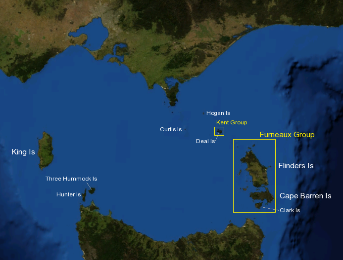
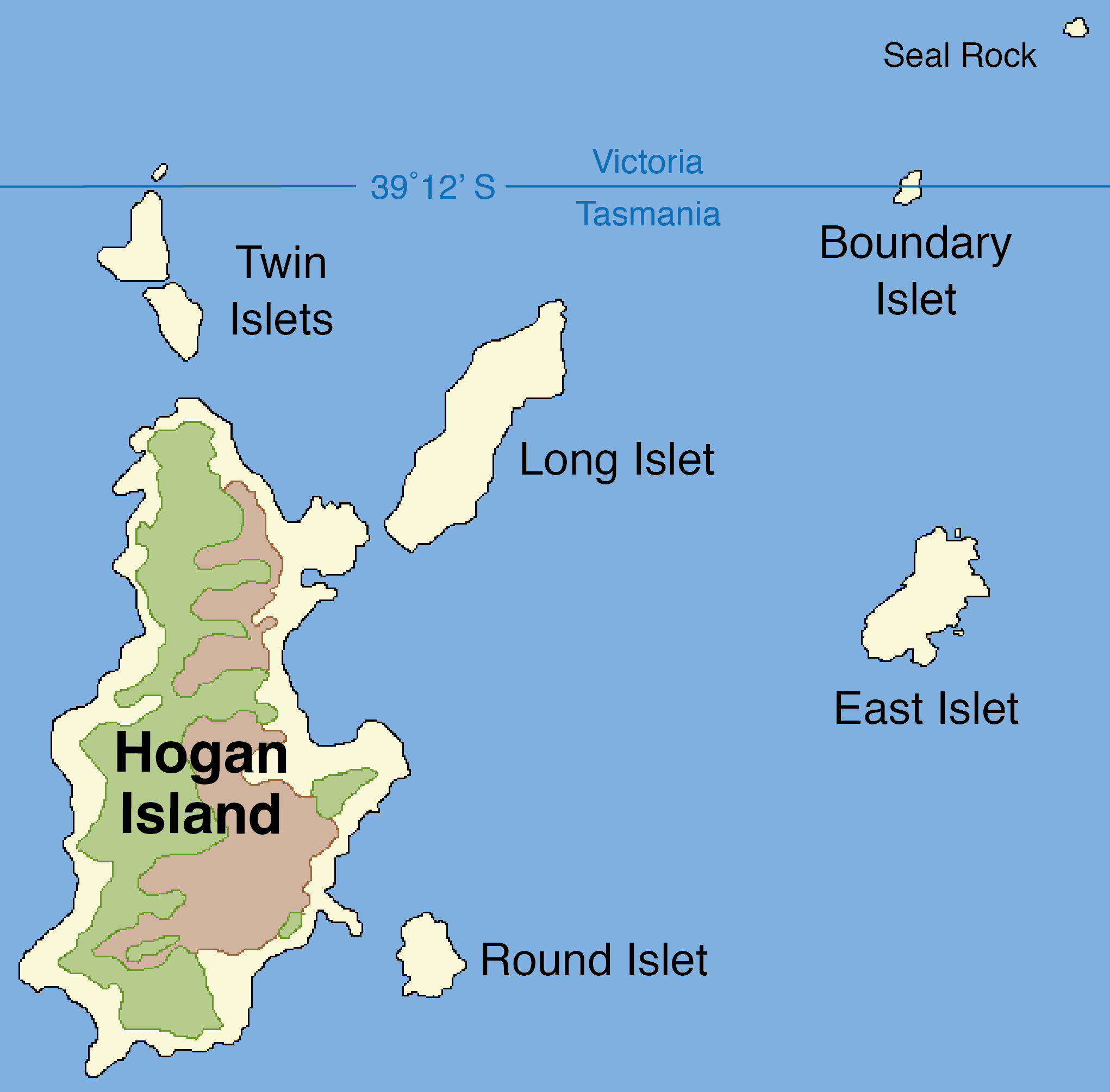
| | | | A Tasmania Land Border? It will come as a surprise to hear that there’s a land border between Tasmania and Victoria, on the mainland. How can that be? When Tasmania was established, it was decided that its jurisdiction would include all the islands in the Bass Strait. On the north (Victoria) side on this map, the large bay is Port Phillip, Melbourne’s harbor, and the peninsula to the right is Wilson’s Promontory, whose South Point at 39°08’06”S is the southernmost point on the Australian mainland (quite a bit further south than Cape Leeuwin in the west at 34°22’S). This was also meant to be the southernmost point of the state of Victoria. On the above map, aside from locating Flinders Island that we spoke about earlier, also note the location of Hogan Island. With its surrounding islets it forms the Hogan Group. | | | | While the original intention was that all these islands be part of Tasmania, the survey made in 1801 based on Wilson’s Promontory was slightly off, and the border was placed too far south at 39°21’S. Thus the border placed a couple of islets in Victoria instead, and beyond that, the line ended up crossing what was then called North East Islet, forming a land border between VIC and TAS. The islet has been renamed Boundary Islet. This land border is just 85 m (279 ft) long, slightly less than a typical rectangular city block in New York, whose shorter dimension is about 80 m (264 ft). It’s Tasmania’s only land border, and obviously the shortest state line in Australia. To change this situation would require an amendment to the Constitution, which is not considered worth while. | | | | Borders Given the low number of states, there actually aren’t that many borders in Australia. Most of them are not only straight-line, they run vertically or horizontally, even the one on Border Islet. Aside from the irregular ACT, the exceptions are two river borders, one being a small area of rivers at the eastern end of the NSW/QLD line near the sea. The major river border is the Murray River between NSW and VIC. Starting on the Pacific coast and running east, the only angular straight-line border between states runs 180 km (112 mi) to the headwaters of the Murray, which then forms the rest of the border between the states. When the Murray flows into SA, it takes a sharp left to flow south, without ever reaching Adelaide. Try finding the four tripoints in Australia, SA being a factor in each of them; one of them lies in the middle of the Murray as it enters SA. | | | | Antipodes I do like the word antipodes (an.TI.po.deez), so often applied to Australia and New Zealand. But limiting it that way is not accurate. The antipodes is the opposite side of a sphere. Pick up a basketball and one hand is touching the antipodes of where the other is touching. The children’s joke. that if you dig a hole deep enough, you’ll “come up in China”, is, aside from being silly, not accurate. China is antipodean with Brazil, roughly, and nowhere else. So where is Australia antipodean to? Pick up a globe with a palm over Australia, and you’ll find the other hand covers very roughly the lower North Atlantic. Sydney is roughly the antipodes of the eastern North Atlantic at about Casablanca (close enough to Europe so that the British have usually implied that Australia is the only “antipodes” there is), leaving Perth to be the approximate antipodes of New York. That’s why it’s so easy for me to calculate the time difference to Australia. If it’s 8 PM in New York, it’s 8 AM in Perth, its antipodes (and 10 AM in Sydney).
| | | | Visiting the antipodes of New York intrigues me. The meridian of New York, 74°W, continues as a Great Circle to 104°E, near Singapore. But Perth is at 116°E, so “my line” falls into the Indian Ocean to the west. Margaret River/Cape Leeuwin is a bit closer at 115°E. Also NY is at 41°N, while Perth is only at 32°S, with Margaret River/Cape Leeuwin again being a bit closer at 34°S. So when standing on Cape Leeuwin, the southwesternmost land point I can reach, I’ll have to look out to sea still further to the southwest to estimate the exact antipodes of New York. | | | | Latitudes I find there’s an amazing coincidence of US locations coinciding with locations in Australia, but in reverse, and all are equatable with rail routes. Picture a rail route from New York south to Miami corresponding to one from Sydney north to Cairns; New York west to Chicago to Seattle, versus Sydney west to Adelaide to Perth; Chicago south to New Orleans versus Adelaide north to Darwin. The only lacking parallel is Seattle south to San Francisco to Los Angeles, since north of Perth, given the Outback and related areas, are no comparable cities.
| | | | But that’s only very rough. Let’s list some locations moving NORTH in Australia with corresponding locations moving SOUTH in the US. (We will just compare latitudes, although other factors affect temperature and weather.) | | | | | | Hobart 43°S……………..Albany 43°N
Launceston 41°S………New York 41°N
Melbourne 38°S……….Richmond 38°N
Adelaide 35°S………….Chattanooga 35°N
Sydney 34°S……….……Atlanta & Los Angeles 34°N
Perth 32°S……………….Savannah 32°N
Brisbane 27°S………….Tampa 28°N
Alice Springs 24°S…..Miami 26°N
Cairns 17°S……………..Santo Domingo 18°N
Darwin 12°S…………….Caracas 11°N
|
| | | | I think it might startle many to see that, for instance, going from Hobart north to Darwin is like going from Albany in upstate New York south to Caracas in South America. It will also be seen that the entire strip of northern US states along the Canadian border, plus ALL of Canada (to say nothing of Europe), correspond to latitudes that would fall south of Australia in the Southern Ocean. To travel “down under” is nowhere as far down under as people living “up over” often think. | | | | Sizes Australia is the world’s smallest continent; the world’s biggest island; and it’s the only nation that encompasses an entire continent. | | | | CITY SIZES To best visualize city size, keep ranges in mind. Sydney and Melbourne are each in the 3-4 million range and Brisbane, Perth, and Adelaide in the 1-2 million range. All other cities are considerably less populous.
| | | | COUNTRY SIZES To compare in size the four settlement countries we’ve been discussing, “ANZCUS”, we have to put NZ aside since it’s only 73rd in size and 122nd in population (4 million). Of the other three, in land area Canada is the 2nd largest in the world, the US 3rd, and Australia 6th. But in population, the US is 3rd (306 million), Canada 36th (34 million), and Australia 53rd (22 million). (In comparison, the UK has 62 million.) | | | | SUBNATIONAL ENTITY SIZES Given the large area of many Australian states, it’s of interest to do a comparison of subnational entities, that is, country subdivisions such as states, provinces, and territories.
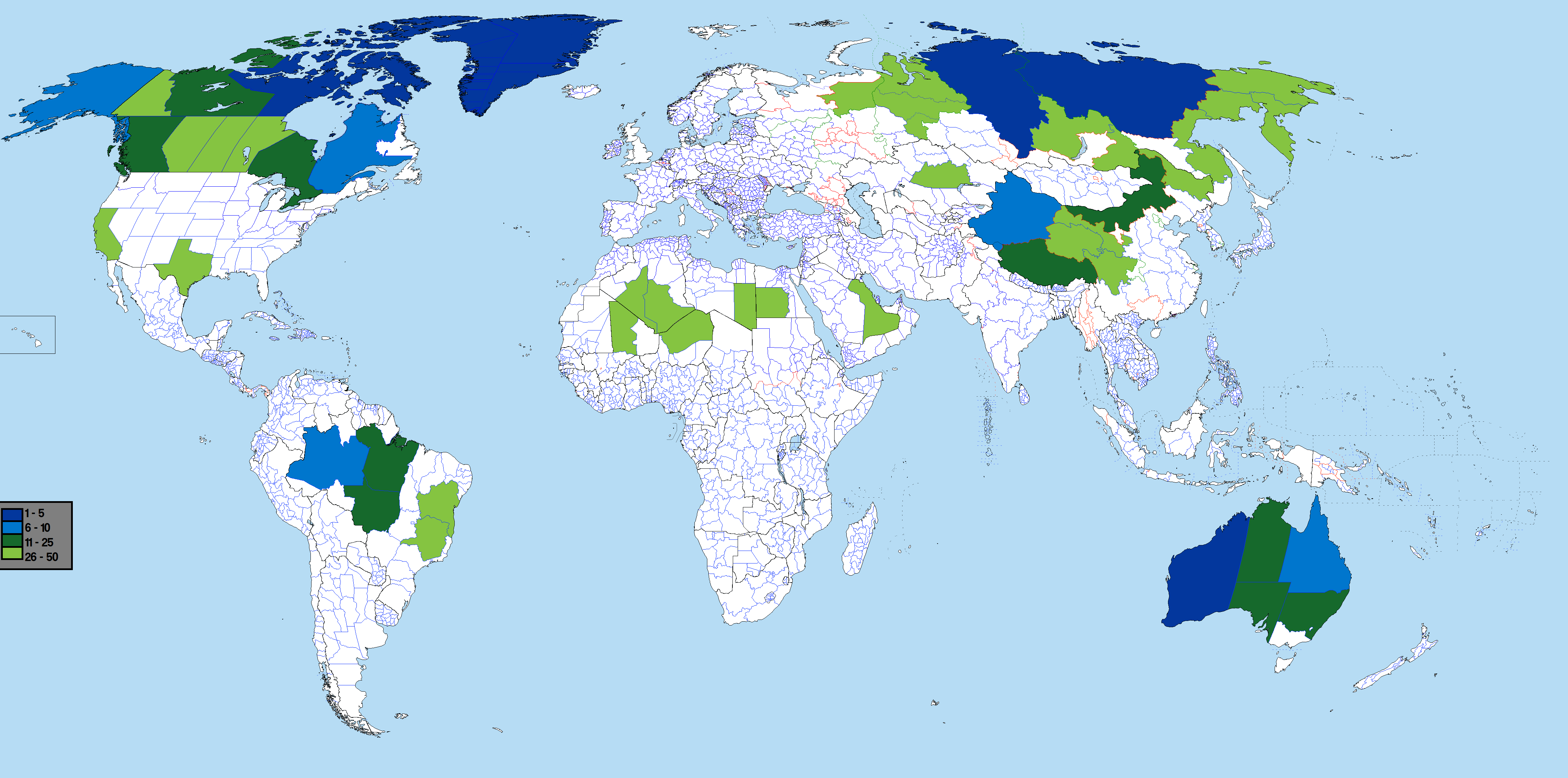
| | | | It’s worth first mentioning that there’s been a change in recent years. Canada’s (old) Northwest Territories used to be the largest subnational entity in the world, stretching from the Yukon to Hudson’s Bay. (The Yukon had been carved out of it in 1898 after the gold rush, and it was still the largest entity.) Then in 1999 the Northwest Territories were divided in two. The eastern part, including many Arctic islands, became the territory of Nunavut, 5th in world size, leaving the remaining western part, the (new) Northwest Territories (with some Arctic islands) to be 12th in world size. | | | | Of the 50 largest subnational entities, Russia has 10, including an area of the Russian Far East in 1st position, and an area in central Siberia in 3rd. China has 7, Brazil 5, Algeria 2, Congo 2. There’s one each in Saudi Arabia, Niger, Chad, Libya, Kazakhstan, and Indonesia. Greenland, all by itself, takes 4th position on the list. But more to the point are these states and provinces, color coded, with their size position out of 50: | | | | | | 2 Western Australia
5 Nunavut
6 Queensland
7 Alaska
10 Québec
11 Northern Territory
12 Northwest Territories
16 Ontario
17 South Australia
18 British Columbia
20 New South Wales
27 Texas
28 Alberta
29 Saskatchewan
30 Manitoba
40 Yukon
49 California
|
| | | | Since the US is so populous, it’s much more finely subdivided, resulting in only Alaska, Texas, and California making the list, so this particular “contest” is really between Australia and Canada (of the countries we’re discussing). The only Australian states that do NOT make the list are Victoria and Tasmania. The only Canadian provinces that do NOT make the list are the four Atlantic provinces of Nova Scotia, New Brunswick, Prince Edward Island, and Newfoundland & Labrador. Australia makes the list five times and Canada nine, but then Australia’s entries tend to be crowded higher on the list, with a low of 20 to Canada’s 40. As a matter of fact, if, instead of doing the top 50, you’re just doing the top 20, the two would be tied with five each. I’d say it’s a draw between Australia and Canada. | | | | Names There are a number of interesting matters dealing with place names. | | | | OZ It’s a bit frivolous and casual to call Australia Oz, but it IS used with some frequency both locally and internationally. For instance, travel brochures referring to trips to Australia and New Zealand refer to OZ/NZ, and the Hugh Jackman musical about Peter Allen is called The Boy from Oz. Sometimes Sydney is even referred to as the Emerald City. What could the connection be?
| | | | You have to look at the year 1900. On 1 January that year, the Commonwealth of Australia was proclaimed, something that had to be on everyone’s mind. Then on 17 May that year, L. Frank Baum published The Wonderful Wizard of Oz, followed by multiple sequels, stage plays, and of course, films. The connection between a new far-off country in fact and one in fiction would not have been difficult to make, both in and outside of Australia. | | | | Then there are the pronunciations. Many Australians pronounce the name of the country as though it were written Ostralia, if not even Oztralia. But the strongest argument can be made for the colloquial nickname Aussie, used to refer both to people and things, as in “Aussies enjoy those wonderful Aussie beaches.” The word Aussie is pronounced by most Americans to be a close rhyme to the name Flossie, but Aussies themselves (and Brits, and Canadians), pronounce the word Aussie as something close to the name Ozzie.
| | | | And if you’re an Ozzie, where else can you be from but Oz? | | | | NEW SOUTH WALES I like this name, but its meaning has always bothered me. Now I find that no one really knows for sure what it refers to, anyway. Wales runs north-south along the coast of the Irish Sea, and people refer to North Wales, where Welsh predominates over English, including on road signs, and South Wales, where the opposite is true. But why would one name an Australian colony (later state) after only half a region? Is it meant to be an insult to North Wales?
| | | | There are two possible explanations I’ve come across: (1) that the name NSW is made up of New + South Wales, honoring only that region of Wales, as I’d suspected, or that (2) the name NSW is made up of South + New Wales, with the explanation that NSW is meant to refer to a New Wales of the South. This latter explanation appears implausible, and a stretch of credibility, but could have something going for it. James Cook coined the name. He also was required to keep three journals, assisted by a secretary, one for himself and others to turn over to the British authorities. But the three journals on occasion vary slightly. Two versions say Cook named the colony New South Wales, but the third version says throughout that he named it simply New Wales, without using “South” whatsoever. This variation could imply that a two-word name was evidently at least considered, and that the second possibility above has some credence. Still, no one can definitively prove the answer to what was meant by this name.
| | | | MELBIN, CANBRA, BRIZBIN, CANS I’m a proponent of accurate spelling that informs the reader of what to say, at very least with place names. You may recall my joking about, for example, place names in France (Eg Mort actually written as Aigues Mortes) and Ireland (Dun Liri written as Dun Laoghaire [but Anglicized to Dun Leary, a compromise]). To those I’ll add the Scottish town of Kircubri (spelled Kirkcudbright) and the New York State city in the Hudson Valley Pokipsi (spelled Poughkeepsie, with precisely twice the number of letters really needed). Many more could be added in these and other countries. | | | | With the understanding that I’m not pointing a finger just at Australia, I’ll mention the city of Melbin. Lovely name, and all Aussies hearing it know to spell it Melbourne. Yet that spelling misleads many outsiders to saying MEL.born. Further up the coast is the capital of Canbra, spelled Canberra. For years I mispronounced the name, stressing the middle syllable, which in actuality, doesn’t exist for most people, and is certainly not stressed. Also, down in Tasmania, Lonceston would be a better rendition for writing the name of the city actually spelled Launceston (see “Ostralia” above).
| | | | Moving up the coast is Brizbin, spelled Brisbane. Even its nickname of Brissy follows the spelling, rather than the more logical Brizzy. And furthest up the east coast is the city of Cans, a pronunciation that outsiders like to joke about. It’s actually spelled Cairns, but pronounced as in “cans of peaches”. Go figure.
| | | | PLACE NAMES OF ABORIGINAL ORIGIN As in North America, where many place names are of Native American origin, many Australian place names are of Indigenous Australian origin, and demonstrate a certain quaintness to the outsider’s ear, such as Canberra ACT, Toowoomba QLD, Woomera SA, Geelong VIC (ji.LONG, rhymes with “bong”), Mandurah WA, (MAN.du.ra). | | | | We used the term “reduplication” when we talked about Hawaiian, as in the name of King Kamehameha (ka+meha+meha), and some languages will regularly say things twice for emphasis (as in Italian “bella bella”/“very pretty”, or Italian musical notation of piano piano/quite softly). One American place name with reduplication is the city in Washington state of Walla Walla. | | | | Aboriginal names do that as well. As a matter of fact, NSW also has a Walla Walla. [The NSW Walla Walla means “many rocks”, while the Washington one means “many waters”. Put another way, “walla walla” means “rock rock” in Australia but “water water” in the US.] Woi Woi NSW is not far from Mooney Mooney NSW. But the best known of these reduplicated names has to be Wagga Wagga NSW (Wagga is an almost-rhyme to “jogger”), which is the state’s largest inland city. (Sometimes, people like to informally call it simply Wagga.)
| | | | Still, it can’t be denied that there’s a trace of humor in these reduplicated names, which is probably why Dame Edna Everage claims to have been born in Wagga Wagga. In addition, there’s a tendency to shorten these names colloquially to just one word, which is why song writer-guitarist Greg Champion wrote You Don’t Call Wagga Wagga Wagga. In it he jokes about shortening other names to just their first element (such as Brisbane to Brissy, above) but the funniest parts deal with “when you come to the double names”, which is where “ya don’t do things by half”. Here are just the two choruses: | | | | | | Ya don’t call Kurri Kurri Kurri
and ya don’t call Gin Gin Gin.
Ya don’t call Mooney Mooney Mooney
and ya don’t call Kin Kin Kin.
Ya never call Pindi Pindi Pindi
and ya don’t call Grong Grong Grong
and ya don’t call Wagga Wagga Wagga, no sir,
callin’ Wagga Wagga Wagga is wrong.
| Ya don’t call Walla Walla Walla
and ya don’t call Curl Curl Curl.
Ya don’t call Mitta Mitta Mitta
And ya don’t call Wool Wool Wool.
Ya never call Pura Pura Pura
and ya don’t call Bong Bong Bong
and ya don’t call Wagga Wagga Wagga, no sir,
callin’ Wagga Wagga Wagga is wrong.
|
| | | | The Ted Egan referred to is a much-respected folk musician and has been a government official. And in the last line, a very well-known Australianism is used, which is worth learning. “Fair dinkum” means “genuine, honest”, as in “a fair dinkum Aussie accent” or “I wanted to be fair dinkum with him”. So remember the mandate at the end of the last verse that “some words are so fair dinkum that you have to use ‘em twice”.
| | | | PLACE NAMES OF WESTERN ORIGIN Of the major place names, only two are copies of places elsewhere. Most notable is Perth WA, named after Perth, Scotland, and having largely outgrown its namesake, just as Portland, Oregon has outgrown Portland Maine. The other is Launceston, named after a locality in Cornwall, England.
| | | | Places named after people use their last names, or first names in the case of royalty. Such names usually use suffixes of some sort, but are very rare in Europe (Kaliningrad, Ludwigslust) and Asia. The colonial ones in Africa (Stanleyville, Rhodesia) are mostly gone, and not common in South America (Bolivia). On the other hand, such names are common in North America (Washingtonville NY, Charlottetown PEI), and show the additional possibility of avoiding any suffix (Jacksonville FL versus Jackson MS). They include Washington DC, Vancouver BC, Halifax NS, Denver CO). This latter method is most common in New Zealand where [Duke of] Wellington is named after a hero, but [Lord] Auckland is named after a patron. Australia, too, has cities named after patrons, political figures, or friends, such as (Lord) Hobart, (Viscount) Melbourne, (Lord) Sydney, (Thomas) Brisbane, (William Wellington) Cairns. | | | | Bass Strait was named after Flinders’ friend, and Darwin was named for the friend of the captain of the Beagle. As previously mentioned, of the Beagle’s three scientific voyages, Charles Darwin’s famous trip was on the second one only, but when the Beagle’s captain, who had befriended Darwin, was charting the north coast of Australia on the third trip, he decided to name Darwin after his then totally unknown friend. When Darwin became famous a full half-century later, Australia found it already had a place named after him. Of all Australian place names, Darwin is the association that everyone easily recognizes. | | | | Places named after women usually involve first names. This can be because of royalty, such as with the state of Victoria, or with the city of Adelaide SA, named after Adelaide of Saxe-Meiningen, the consort of King William IV (who got the main north-south street in the city named after him, instead). But there is no royalty involved in naming Margaret River (the river, town, and wine region) after Margaret Wyche, the cousin to founder John Bussell of nearby Busselton.
| | | | And then there’s the city with three versions of its name, Alice Springs, or Alice, or, oddly, the Alice, located close to the exact center of the continent. The Australian Overland Telegraph Line (above), which, as in many countries, fell under the jurisdiction of the Post Office, had a telegraph station in Alice Springs, and the (usually dry) Todd River there was named after Sir Charles Todd, Postmaster General of South Australia (note the SA-to-NT connection again). The town, on the other hand, was named after his wife, Alice Todd. | | | | Also in the NT is Uluru/Ayers Rock and Kata Tjuta/the Olgas (Tjuta is JU.ta). In both cases, the Western names had been given indiscriminately, and in recent years, the aboriginal names were revived, and eventually put in first position in what otherwise remains dual naming. Note that just the aboriginal names are used in the name Uluru-Kata Tjuta National Park, a World Heritage site. The Ayers was Sir Henry Ayers, Chief Secretary of SA (!!!) The Olgas are a group of rock formations centering around Mount Olga, which has a royal derivation. Baron Sir Ferdinand von Mueller was a distinguished 19C German-Australian botanist who had a number of mountains and waterways named for him. In 1871, Queen Olga of Württemberg (today part of the German state of Baden-Württemberg) named him Freiherr (Baron), so in 1872, to repay the compliment, he named Mount Olga after her, and by extension, the surrounding rock formations. But today, the original name Kata Tjuta is used, which you should not shorten to just its first element, because | | | | | | ya don’t call Wagga Wagga Wagga, no sir,
callin’ Wagga Wagga Wagga is wrong.
|
| | | |
| |
|
|
|

