|
Reflections 2010
Series 11
July 17
Oz Preview IV: Settling & Subdividing Australia
| | I hope it was clear earlier that I was trying to point out the dichotomy of the Western arrival in Australia, that early on, Australia was poised to be discovered, and was, from the west, from where European shipping came; then only later was the east coast discovered and settled, so that today Australia centers on the large, populated area on the (south)east coast. I do not intend to give the history of Australia, but will discuss here next only the original settlement, and then expand to how the country was subdivided into six states.
| | | | The big item to keep in mind is the time difference. It was almost two centuries (early 1600’s to late 1700’s) between the earliest discoveries on the west coast and eventual settlement on the east coast. This could be compared with the US, which was discovered in the same early 1600’s time period and where settlement started promptly (see 2009/21-25, covering the US years 1600-1800).
| | | | But as to the settling of Australia, we have to make reference to the prisoner situation, which I will touch on only fleetingly. But first this.
| | | | The Mikado I have two quotes on two different subjects from Gilbert & Sullivan’s Mikado (1885). First, Ko-Ko, the Lord High Executioner, tells in a comic aria about finding people to practice his craft on. He says “I’ve got a little list . . . of society offenders . . . who never would be missed!” Two lines in the second verse have always disquieted me: | | | | | | Then the idiot who praises, with enthusiastic tone,
All centuries but this, and every country but his own.
|
| | | | I’ve remained wary of these two lines since I first learned them as a teenager from a recording I had of the renowned Ko-Ko portrayer, Martyn Green. As a traveler and language specialist I’ve always had fundamental interests in history and geography, both basic travel tools, but did not want to end up being that “idiot” praising all centuries but the present one or all countries but my own. But then there are so many centuries out there to investigate, and so many destinations--such a complex time-and-space matrix. I think, as an amateur geographer, I’ve adequately blended US and other destinations, and as an amateur historian, I’ve included a multitude of centuries, although I think the reader might suspect a slight bias on my part toward the 1600’s, and particularly toward Dutch exploits in that period.
| | | | Secondly, later on, the Mikado himself sings the comic aria about how humane he is: | | | | | | My object all sublime
I shall achieve in time:
To let the punishment fit the crime,
The punishment fit the crime.
|
| | | | We shall consider these words in the settling of Australia. | | | | The Convict Issue We have to start with the given that it had been British policy to rid itself of “undesirables” by sending them into exile. The French did the same in Devil’s Island starting in 1852, and the Russian tsars always had Siberia. The British established penal colonies in New South Wales and Van Diemen’s Land and prisoners arrived there along with the regular settlers. Exile should not be confused with life sentences. On the First Fleet to arrive in Australia, while a couple of prisoners did have life sentences, most had sentences of 7 years and a few had 14. There were actual prisons, such as Port Arthur near Hobart, it was primarily used for re-offenders and the most hardened criminals. Woman convicts were usually placed in workhouses called female factories. Still, the heritage of the convicts remains. Many historic buildings boast of having been designed and built by convicts, and the main highway between Hobart and Launceston, now re-named the Heritage Highway, was completely convict-built. | | | | A major question is, why did Britain start this populating of Australia by sending convicts starting in the late 1780’s (the First Fleet left in 1787 and arrived in 1788)? It has a surprising answer. It’s because of the American Revolution of 1776-1783, which prevented Britain from continuing to send prisoners to the American colonies. Presumably the four intervening years involved Britain reestablishing deportation plans.
| | | | Both fame and infamy are hard to explain. Why should Australia be well-known as a destination for British convicts while the US is conveniently forgotten as being the previous destination?
| | | | [An example of this is the joke I’ve heard comedian John Martin tell on Cunard ships: “I landed in Australia and they asked me if I had a criminal record. I said I didn’t think it was still a requirement!!!” It is unfair, although still a cute joke. Still, no one would think about making the same joke regarding the US, because that part of US history is not well known to begin with, and then conveniently forgotten, anyway.]
| | | | Britain had used North America as a penal colony through a system of indentured servitude. Indentured servants, often laborers or tradesmen, in exchange for transportation, food, clothing, and lodging, would contract to work for a period of three to seven years, after which, as long as they weren’t exploited, making it hard to break away at the end of the allotted time, they could set out on their own. Merchants would transport convicts and auction them off to plantation owners on arrival. It is estimated that some 50,000 British convicts were sent to colonial America, representing about 1/4 of all 18C British emigrants. (Including those people who voluntarily indentured themselves to get to America, the quote goes up to 2/3 or 4/5 of the population that was in America on less than a totally free basis.) Virginia and Pennsylvania in the 17C-18C were largely populated by British and German-speaking indentured servants.
| | | | Given the notorious rate in those centuries of hangings and other executions, it can be assumed that many of the most serious criminals never left Britain. Of course, some hardened criminals were, but of all those that were sent into exile, it can also be assumed that by today’s standards, for many, the punishment, to quote the Mikado, didn’t fit the crime. To this we can cite one of the greatest novels of the 19C, Victor Hugo’s 1862 Les Miséarables or the musical made based on it, in which Jean Valjean, having stolen some bread for his starving sister and her family during a time of economic and social crisis, is sent to prison for years, and thereafter has to carry papers labeling him as a convict. | | | | The lists of names of convicts and ships sent to Australia are still available (check Wikipedia), but I got to review one more intimately for just a bit on television while researching these articles. I’ve mentioned the globe I saw on the British Antiques Roadshow and, on another one of those shows I saw something even more interesting. A woman presented for appraisal an item handed down by an ancestor. It was his doctor’s log from when he had sailed as a physician on an 1857 convict ship to Van Diemen’s Land. As the appraiser commented and turned the pages, the camera looked over his shoulder. I was able to pause the DVR and read more carefully and copy down the entries I saw.
| | | | Next to the column of names was a column of places, such as Gloucester or Bristol. These were not where the person was from, but, in a burst of additional impersonalization, was the location of the sentencing court. The column of occupations was very revealing: hairdresser, labourer, carpenter, shoemaker, bookbinder, weaver, and “agriculturer”, presumably a farmer. Given that Australia needed skilled labor, it is evident that the arriving prisoners, upon release some years hence, would eventually contribute substantially to Australian society. But the most impressive column was the next one, noting the “crime” for which the person was being sent into exile for years. I’ll list below the ones I was able to copy out of this log:
| | | | | | Writing forged check
Sheep stealing
Stealing a coal bucket
Stealing sheep skins
Killing a sheep
Stealing wheat
Stealing sugar
Burglary
Housebreaking & larceny
|
| | | | This 1857 log book is contemporary with Hugo’s 1862 novel. We are talking about exile, probably (but not necessarily) for life, and prison terms for perhaps 7 or 14 years. Other than perhaps for the last two, does the punishment fit the crime? It was chilling to look at the logbook and realize these were all real people involved in what in today’s eyes would be considered rather trivial crimes.
| | | | Others sent in exile were advocates of Irish home rule and trade unionists. Of course it wasn’t just prisoners that settled Australia. South Australia was particularly proud to have been founded exclusively as a free colony, but free settlers also arrived at the colonies that accepted prisoners. I saw last year on Public Television the 1999 version of David Copperfield (written 1850) starring a pubescent, pre-Harry Potter Daniel Radcliffe and recall the memorable scene where Wilkins Micawber and his family were embarking on a ship to emigrate to Australia. He was leaving as a free man, although he’d had a lifelong struggle in and out of debtor’s prison, and was to become a successful sheep farmer and magistrate. But nearby, a chain gang was boarding as well, which included a barefoot Uriah Heep in rags, convicted of fraud and thievery, and also headed for Australia. | | | | [While on the subject, we can also mention Dickens’ 1860-1 Great Expectations, where Pip befriends an escaped convict, Magwitch, headed for Australia. Eventually, Magwitch prospers in New South Wales and sneaks back to Britain to become Pip’s benefactor.] | | | | Settling Australia - The First Fleet To understand how the original settlement area developed, we need to review the geography of the Sydney area, and two maps will help. First review this satellite image. To the right is the Pacific Ocean, and there are two indentations in the land. The lower one is Botany Bay, fed by the Georges River entering from the SW, but also by the Cooks River entering from the NW, right where two runways from the Sydney airport also enter the bay. The upper indentation starts on the left as the Paramatta River, which widens into a huge estuary on its way to the Pacific. Traditionally and formally, this estuary is called Port Jackson, but in common usage it’s just called Sydney Harbour. Sydney lies on the south bank, its center oriented northward. | | | | To supplement the satellite image, also review this political map, which shows there is actually a municipality called Botany Bay encompassing the runways. Sydney is right above it, with some waterways on its left side. The point of land immediately to the right of those waterways contains Sydney Cove, and Circular Quay, both the historic and present heart of the city.
| | | | Just as happened in the US, the location of the first landing was different from the first settlement. Recall that Cape Henry was the first landing for Jamestown in Chesapeake Bay, Governor’s Island for Manhattan in New York Bay, and, particularly famous, the Provincetown area for Plymouth in Cape Cod Bay. | | | | Less than 18 years before the First Fleet, James Cook had discovered Botany Bay on 29 April 1770. As was the norm, scientists always accompanied this sort of expedition, and two botanists accompanied Cook, one of them being the same Sir Joseph Banks who later discouraged Flinders from promoting the name Australia. The botanists collected around the bay a great number of interesting plants, among them some unique specimens, including acacia, mimosa, and the already-discussed eucalyptus. This caused Cook to name the bay at first Botanist Bay, for the two scientists, which later changed to Botany Bay, for the science itself. Cook was aware of the existence of Port Jackson, although he never visited it personally. Yet he was convinced that Botany Bay would be the ideal location for the first settlement.
| | | | In May 1787, eleven ships, now known as the First Fleet, left Portsmouth, England for Australia. They were the size of the ferries in Sydney Harbour today (of which there are nine, all named after First Fleet ships). Records show that 1403 people left Plymouth, but there were births and deaths during the long voyage, and 1332 arrived. They consisted of 14 officials and passengers, 269 crew members, 245 marines, 54 marines’ wives and children, 543 male convicts, 189 female convicts, and 18 convicts’ children.
| | | | The voyage of the First Fleet is considered one of the world’s great sea voyages. Consider the number of people, with sufficient supplies for all of them. No ships were lost, on a trip lasting 252 days (8.4 months), and covering over 24,000 km (15,000 mi). They reached their destination in January 1788 (mid-summer).
| | | | They pulled into Botany Bay between the 18th and 20th to what turned out to be disappointment, since the bay did not live up to their expectations based on Cook’s glowing accounts. They found the soil was poor, being too sandy and infertile, or otherwise swampy. They found the fresh water supply to be poor and inadequate. They also found that there was no good anchorage, since the bay was open, unprotected, and didn’t have a natural harbor. | | | | But further investigation during the week they stayed in Botany Bay showed that Port Jackson, some 12 km (7.5 mi) to the north, had in abundance all the things Botany Bay lacked. Sydney Cove, a small bay on Port Jackson’s south shore, also had sheltered anchorages, and a fresh-water stream flowing right into it. So early on 26th January the entire First Fleet pulled out of Botany Bay and arrived that same day in Sydney Cove, on what, by a truly amazing coincidence, just happened to be Australia Day.
| | | | Just kidding, to see if you’re paying attention. Let me rephrase that. In 1788 the First Fleet arrived in Sydney Cove on 26th January, which is today celebrated as Australia Day.
| | | | Thus we see that the first landing was at a slightly different location than the permanent settlement, just as in the three American settlements mentioned, the only difference being that the three American first landings were purely by chance, while Botany Bay had been scouted out and planned in advance.
| | | | In addition, despite the move to Sydney (Cove), the name Botany Bay had become quite embedded in British thinking in reference to the penal colony, and so it remained in use for many years in that connection. In Great Expectations, the convict Magwitch (above) on his return to England specifically says he’s back from Botany Bay, and this 1998 memorial in eastern Ireland not only uses the name Botany Bay but also indicates the political nature of some convicts’ cases.
| | | | Finally, this is a picture at dawn of Sydney Cove today. To see the dawn, the picture was aimed (north)east, so do realize that north is to the left, where all the ferries are facing. On the far (east) side of Sydney Cove is the Sydney Opera House, and on the near (west) side is the historic neighborhood called The Rocks, as well as the Sydney Harbour Bridge at a slight angle. Surrounding the Cove is Circular Quay, with its ferry terminal, City Circle train station, and road and bus connections (“sail-rail-trail”). It is not circular, but was originally called Semi-Circular Quay, since shortened. It is remarkable that the original permanent landing and subsequent settlement location at Sydney Cove is still the major transit hub that it is. However, the fresh-water stream flowing into the Cove that enticed settlement here in the first place became inadequate and befouled within the first couple of decades of the settlement, and was long ago put underground. Win a little, lose a little. Sic transit gloria mundi.
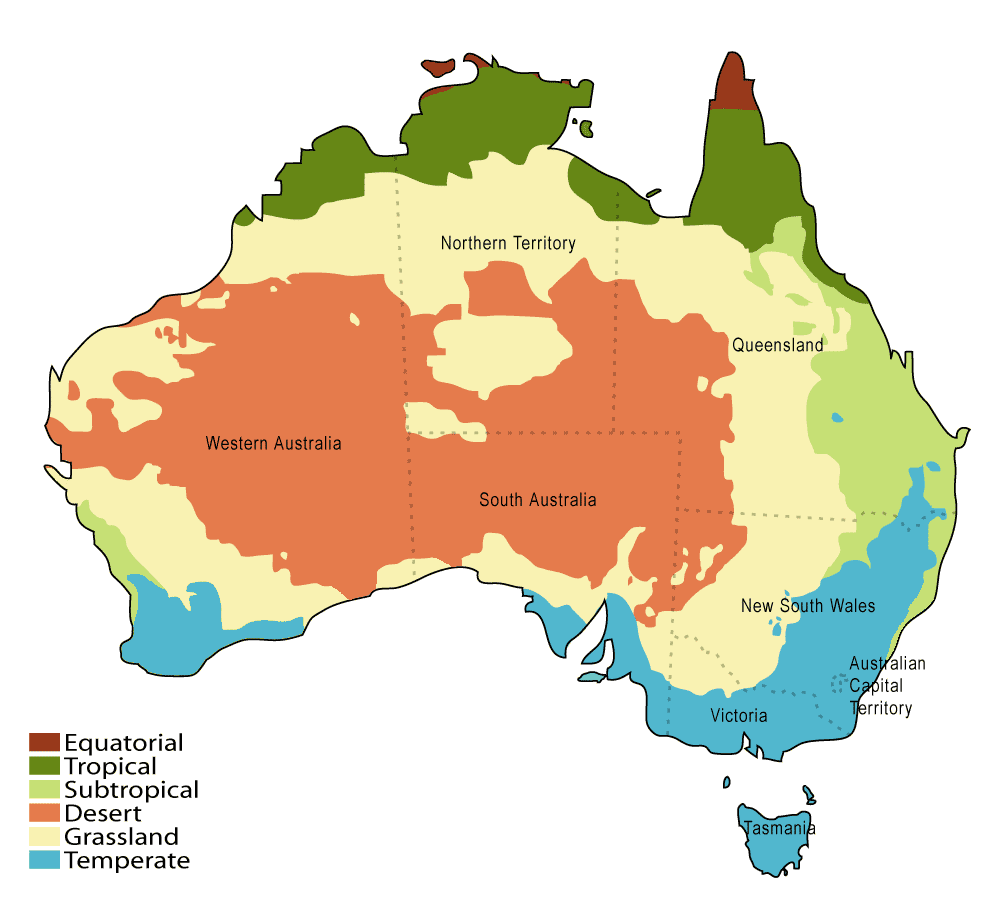
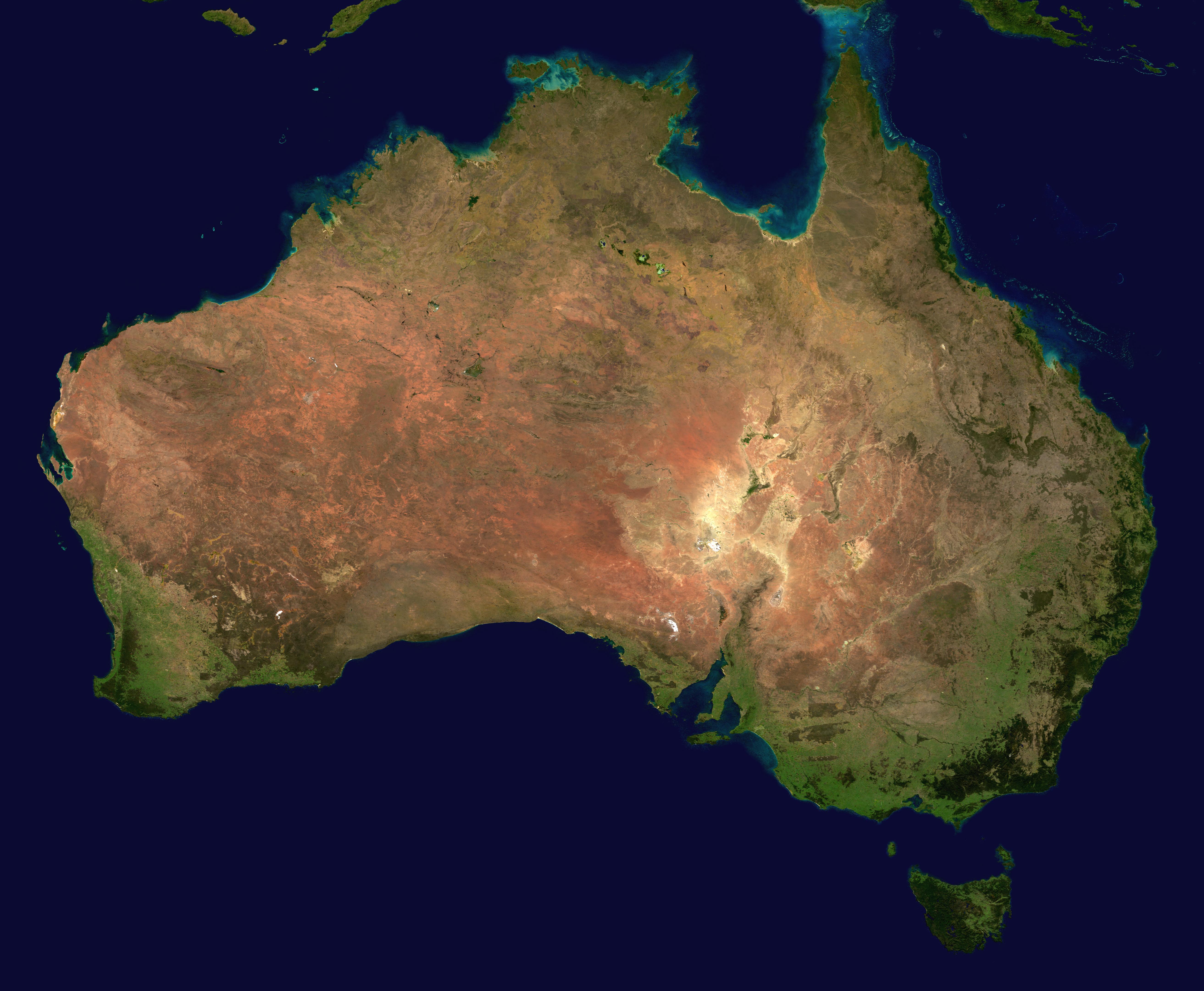
| | | | The Climate & the Outback In Australia climate dictated settlement, as shown by this map of Australian climate zones. | | | | Although the term “Outback” is often used to describe any area outside the major coastal cities (“the area set OUT BACK of the coastal populated areas), strictly speaking, it’s only the vast, most remote, and driest areas furthest inland (brown on the map). The term “bush” describes an intermediate wooded area (beige), which is still dry, and likened to something between forest and shrubland. The population is concentrated in the two areas on this map in blue and light green: the larger one constituting the temperate arc of the southeast, extended north up the subtropical Queensland coast, and the smaller subtropical one on the southwest coast, between Perth and Margaret River. | | | | Looking at Australia by its three time zones, Western, Central, and Eastern Standard times (WST, CST, EST), the east has the least involvement in the (brown) Outback; Tasmania and Victoria none at all, and New South Wales and Queensland only on their extremities furthest inland. The west, which consists only of Western Australia, is primarily Outback and related areas. Two statistics are revealing: WA has only 10% of Australia’s population, and 80% of WA’s population lives in that southwestern area. In the center, while the Northern Territory is exclusively Outback and related areas of low population, South Australia and the Northern Territory can be considered as a unit (and once was one--more on this later), and the two together offer in my mind a mirror image of Western Australia, with the population concentrated in the temperate area centering around Adelaide in the southeast, which contains over 70% of the population of SA. Consider what we’ve been saying while reviewing this satellite image from space.
| | | | Two things can be pointed out now regarding the western and central regions: (1) Perth is considered the most remote major city in the world, given its distance from the populated east, and (2) in an attempt for the center to cling more closely to the east, Central time is only a half-hour earlier than Eastern time, not an hour (with a corresponding 1.5 hour time difference to the west) . In other words, if it’s 1:00 in Perth and 3:00 in Sydney, it’s NOT 2:00 in Adelaide as you’d expect, but only 1:30.
| | | | Thus the focus in the populating of Australia was the accessible and fertile coastal areas, yet the Outback provides Australia with a backdrop deeply valued within the culture.
| | | | Subdividing Australia The history of the subdivision of Australia is relatively simple, since there are just six states, a major territory, and a capital territory, as compared, in the other large settlement countries, to the many US states and the numerous Canadian provinces. We already know from the Flinders map that New Holland encompassed the west coast and New South Wales the east coast. However the Dutch never precisely defined the inland limit of New Holland, while, when New South Wales was declared to be a colony on 26 January 1788, it was precisely defined as extending to the meridian at 135°E, effectively dividing the continent in two. While this is a very historic border, it was later moved and no longer exists, so in considering the whole scheme of things, remember it as temporary. The capital of NSW is Sydney, which bears the same 1788 founding date as NSW and is therefore the oldest city in Australia.
| | | | To properly understand developments, note that New Holland was never subdivided at all, while NSW was subdivided extensively, down to its present size (although still the most populous state). This can be compared to developments in the US, where the province of Carolina was radically subdivided (2009/21) and Virginia was extensively as well (2009/22). A significant point is that NSW at this time also encompassed the islands in the Pacific, including New Zealand and Tasmania. New Zealand, after first formally being annexed to NSW in 1840, then became independent later that year (2009/8), while Van Diemen’s Land, as described in 2010/10, became its own colony in 1825 and had its name changed to Tasmania in 1856. The capital of TAS, Hobart (1803), and its other large city, Launceston (1806), are the second and third oldest cities in Australia. This map shows the change in Van Diemen’s Land, but more significantly, the move of the western border of NSW in that same year to 129°E, its permanent and present location. While this gave NSW now roughly 2/3 of the continent, its significance is that it’s the most historic border in Australia, since it (1) was the only truly international border between two different nations there ever was on the continent, (2) has permanently defined to this day the location of where New Holland had been, (3) is the longest of Australia’s many straight-line borders, typically running due N-S, and (4) is the oldest of all the state lines. In my own mind, it’s a monument to Matthew Flinders, who had cautioned that it would be an “injustice” (2010/10) to both the Netherlands and Britain if their separate claims were to overlap. | | | | But Flinders was unfortunately wrong. Just four years after this line was drawn, in 1829 Britain formally claimed New Holland, which the Dutch had never settled, under the name Swan River Colony (after the river in Perth, the capital), and just four years after that, the colony’s name was changed to Western Australia in 1832. As with European discovery most significantly starting on the west coast, it may also seem counterintuitive that the first additional mainland colony should again be in the west. It has also struck me unusual that the colony, and eventual state, was never called, in a bolder and more forthright manner, “West” Australia (as South Australia later did), but has maintained the purely geographic “western”.
| | | | We are up to three colonies, and the other three, plus two remaining territories, were all carved out of NSW. The first came just four years further on, when South Australia (capital Adelaide) was proclaimed in 1836 as the first free (non-convict) colony. Its original shape was a bit short of what it is now. Its western boundary was not at the 129° line with WA, and not even at the former 135° line, but curiously halfway in between at 132° instead. It wasn’t until 1860 that the western SA line was finally extended to WA.
| | | | I had always felt that Tasmania, given its island position, never had any expansionist urges, and I was surprised to find I was wrong. Where would it expand to? The mainland, right across Bass Strait. Because of the shortage of good pastureland, interest had developed in Tasmania in the north shore of Bass Strait. Credit is given to John Batman, who came over from Tasmania and in 1835 founded the city of Melbourne. A gold rush prompted the founding of Victoria in 1851. Although VIC is the smallest mainland state, it’s the second most populous. | | | | The colony of Queensland was declared in 1859 (capital Brisbane) and settlement commenced later that year. Its western border was at first set to coincide with the SA border at 141°, but when the SA border was extended west in 1860, the QLD border was also moved west to 139°, in 1862. Both moves are shown on this map. | | | | Thus, except for two territorial matters, the borders of the six Australian colonies, which, at the dawn of the 20C on 1 January 1901 became the six states of the Commonwealth of Australia, were all established in the 37 years between 1825 and 1862.
| | | |
| |
|
|
|

